Feasibility Study. Prepared by Dufresne-Henry. West Side Road. Hinesburg, Vermont. February DH Project No
|
|
|
- Gervase Jones
- 5 years ago
- Views:
Transcription


1 Feasibility Study West Side Road Hinesburg, Vermont Communities working together to meet Chittenden County s transportation needs February 2004 Prepared by Dufresne-Henry DH Project No
2 100 Dorset Street, Suite 22 South Burlington, Vermont T F info@ccmpo.org The preparation of this document was financed jointly by the eighteen municipalities in Chittenden County and the Chittenden County Transportation Authority; the Vermont Agency of Transportation; and the United States Department of Transportation, Federal Highway Administration, and Federal Transit Administration. Submitted by:
3 CCMPO Board James Condos, South Burlington Chair Jeff McDonald, Charlotte Vice Chair Michael O Brien, Winooski Secretary-Treasurer Gerard Mullen, Bolton William Keogh, Burlington Chris Conant, Colchester Jeff Carr, Essex Andrea Morgante, Hinesburg Richard Moulton, Huntington Robert Penniman, Jericho James Manley, Milton Virginia Clarke, Richmond Phil Beliveau, St. George Norman Silcox, Shelburne Stan Hamlet, Underhill Tom Buckley, Westford George Gerecke, Williston Michael O Brien, Winooski Pat McDonald, State of Vermont Chris Cole, CCTA (Ex-officio) Lewis Wetzel, CCRPC (Ex-officio) Christopher Jolly, FHWA (Ex-officio) CCMPO Staff Paul Craven, Project Manager Bernadette Ferenc, Administrative Assistant Christine Forde, Sr. Transportation Planner Peter Keating, Sr. Transportation Planner William Knight, Executive Director David Roberts, Transportation Planner Susan Smichenko, Sr. Transportation Planner Daryl Benoit, Transportation Planner Project Steering Committee David Roberts- CCMPO Alex Weinhagen Town of Hinesburg Jeanne Wilson Town of Hinesburg Fred Haulenbeek Town of Hinesburg Rocky Martin Town of Hinesburg John Buckingham Town of Hinesburg Randy Volk Town of Hinesburg George Bedard Town of Hinesburg Christopher Pecor - Dufresne-Henry Feasibility Study iii
4 Contents 1.0 Executive Summary Potential Alternatives Preferred Alternative 4 3.1Alignment Permitting/Resources Benefits... 6 Appendix A Alternative Alignments Appendix B Prefered Alignment Appendix C USGS Draft Flood Study, September 24, 2003 Appendix D Miscellaneous Correspondance iv Feasibility Study
5 Figure List Figure 1 Permitting Requirements...3 Figure 2 Physical Characteristics...3 Feasibility Study v
6
7 1.0 Executive Summary The Chittenden County Metropolitan Planning Organization (CCMPO) is responsible for performing long and short-range transportation systems analyses for Chittenden County. CCMPO has been working with the Town of Hinesburg to evaluate a range of transportation issues associated with Vermont Route 116 through Hinesburg. Dufresne-Henry (DH) was retained under the CCMPO Technical Assistance Grant Program to assist the Town of Hinesburg, Vermont. The goal was to determine the feasibility of a new north/south alternative alignment west of Route 116, from Silver Street, just south of the Route 116 intersection, to Shelburne Falls Road. Existing Conditions The northern terminus for the Hinesburg Village West Side Road Feasibility Study is just west of the signalized four way intersection of Shelburne Falls Road, CVU Road, and Route 116. This area is known as Ballards Corner and includes a small commercial center, the new town library and nearby CVU High School to the east. Continuing south, the project limits are bounded by wooded areas and the LaPlatte River on the west and Route 116 to the east. The terrain is mostly open agricultural flats. Approaching the village from the north, the eastern limits are defined by Route 116. The area includes the developing Hinesburg Commerce Park, a new post office along with mixed commercial and light industrial development that has become a new village center. The entrance to this new village center is marked by the three-way intersection of Commerce Street and Route 116 opposite the fire station. Commercial development continues south along both sides of Route 116 to the three way intersection at Mechanicsville Road. The creamery plant on the west side of Route 116, opposite the entrance to Mechanicsville Road, marks the end of the predominantly commercial development and the beginning of the old village section of the Hinesburg corridor. The western limits of the project area include the LaPlatte River and beyond. South of Charlotte Road the western limits include the LaPlatte River but are closely bounded by steep hillsides as the project approaches Silver Street at its southern terminus. The character of the old village center from Mechanicsville Road to Silver Street consists of older homes, newer senior housing, several churches, the Town Hall and a few small businesses, including Lantman s IGA opposite Charlotte Road. Route 116 traffic peaks during the morning and afternoon commute as this area provides employment support to the Burlington area. Feasibility Study 1
8 Goals and Objectives The Primary goals of the alternative alignment feasibility study are described below: 1. Provide a conceptual plan for an alternative street network to be used primarily by the local community. Consequently, Route 116 would remain the primary roadway for commuter traffic. 2. Provide an opportunity for in-fill type mixed use development to promote dense development within the village core instead of the more common linear type development found on many of the state routes in our Vermont towns. The specific objectives of the study include: 1. Identify potential alternative alignments 2. Determine the preferred alignment 3. Provide a list of constraints for the preferred location 4. Develop conceptual construction cost estimates for logical roadway segments 5. Identify the potential benefits of a west side road 2 Feasibility Study

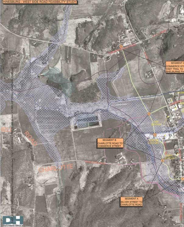
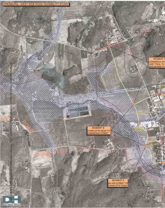
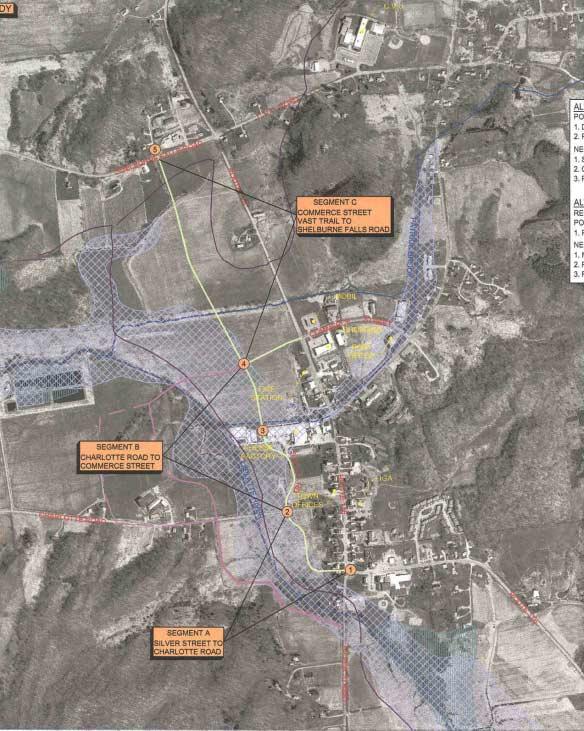
9 C.V.U.H.S. LIBRARY CVU ROAD BALLARDS CORNER SHELBURNE FALLS ROAD ROUTE 116 MECHANICSVILLE ROAD COMMERCE STREET POST OFFICE CHEESE CO. STELLA ROAD TOWN HALL CHARLOTTE ROAD LYMAN MEADOWS ELEM. SCHOOL BUCK HILL ROAD FRIENDSHIP LANE SILVER STREET Figure 1: Project Location Map Feasibility Study 3
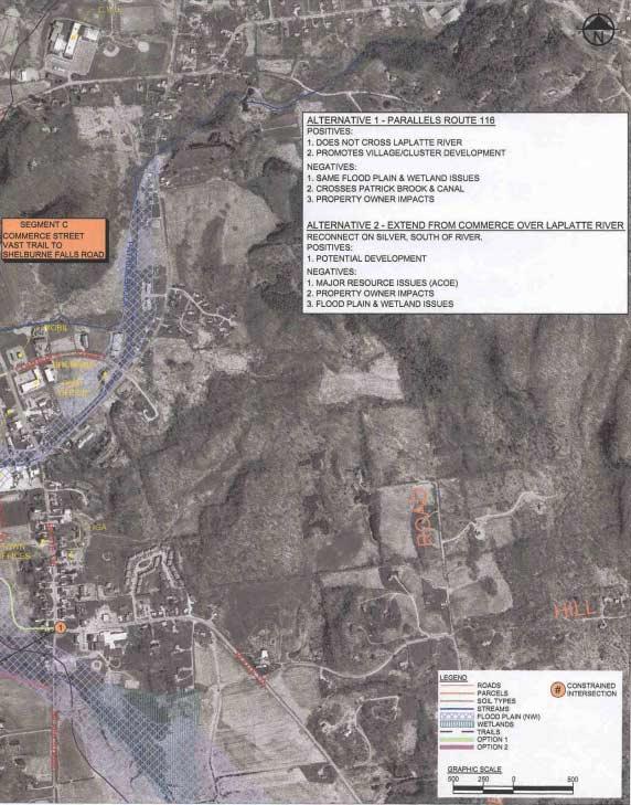
10 2.0 Potential Alternatives A site visit with the steering committee members identified two (2) general opportunities for a west side road alignment. The alignments are shown on the map provided in Appendix A. The most appropriate beginning or southern terminus was identified as south of Charlotte Road with a connection to Silver Street. The end, or northern terminus, was identified at Shelburne Falls Road, and directly across from Pleasant View Lane. Option 1 Shown in green. Generally located east of the LaPlatte River. Benefits: 1. Meets goal of road. 2. Close proximity for dense development. 3. Cost and environmental impacts are less than Option 2. Challenges: 1. Permitting 2. ROW issues with Saputo. 3. General ROW issues. Option 2 Shown in red. Same northern terminus, but crosses the LaPlatte River at Commerce Street, then runs west of the river to Silver Street. Benefits: 1. Meets goal of road. Challenges: 1. More costly than Option 1, due to additional length of road, a bridge and more ROW acquisition. 2. More difficult permitting since it will need Army Corp. permit to cross LaPlatte River. 3. More prime agricultural land and wetland impacts 4. More ROW issues than Option 1. Recommendation: Since Option 1 is less costly, has less environmental impact, has fewer permitting issues, requires less ROW impacts, and offers more dense development opportunities, the steering committee supports Option 1. 4 Feasibility Study
11 3.0 Preferred Alternative As described in Section 2, the preferred alternative generally is located east of the LaPlatte River. 3.1 Alignment The preferred alignment location is constrained at various points along the route while offering opportunities for flexibility within those fixed points. Starting from the southern terminus the following fixed points will define the proposed alignment (see map in Appendix A): 1. Southern Terminus at the Silver Street/Route 116 intersection. Ideally, the alignment should be located at this existing intersection, creating a four-way intersection; otherwise two offset tees would result. The disadvantage here is right-of-way constraints. 2. Connection with Charlotte Road is at the existing intersection of Stella Road, creating a 4-way intersection. This also avoids crossing the LaPlatte River. 3. As the road proceeds north, it needs to go west of the existing Stella Foods Facility, but east of the existing lagoons. If the treatment lagoons are relocated then this point can be shifted further west. An agreement with Stella Foods is required. 4. The intersection with the future Commerce Street Extension should be located approximately in a straight line extended from the existing Commerce Street west of Route 116. The newly created three-way intersection will complete the inner boundary of the new village center area. The western limits are generally defined by the 100 year flood plain. 5. The northern terminus should be located at the intersection of Pleasant View Lane and Shelburne Falls Road (approximately 700 from the Route 116 intersection). Lining up with Pleasant View Lane provides a four-way stop controlled intersection. The 700 feet from the signalized intersection should provide adequate separation to avoid conflicts with queuing. Generally, the segments between each of the fixed points can be designed to optimize dense development opportunities while minimizing impacts to natural resources. The alignment should be placed east of the limits of the 100 year flood boundary determined by the preliminary report from USGS. However, the actual final location may be very different from that shown on the plans. Factors affecting the alignment include: 1. Roadway Purpose development access or alternative local route. 2. Development goals and objectives. 3. Goals for pedestrian use. A summary of the physical characteristics of each segment is included in Table 3.1. Feasibility Study 5
12 Characteristics A (Silver St. to Charlotte Rd.) Segments B (Charlotte Rd. to Commerce St.) C (Commerce St. to Shelburne Falls Rd.) Soils Not free draining Existing road Not free draining ROW Impacts (# of properties) 3 (residential) 1 (Saputo) 1 (Farm) Current Land Use Residential Length 1,100 Mixed Use Commercial/Village 1,800 plus 800 for Commerce Ext. Agricultural 2,900 Estimated Construction Cost (1) $1.0 M $2.3 M $2.6 M Table 3.1 Physical Characteristics (1) Assumptions: Avg. unit price of $900/LF based on characteristics of similar projects. Planning purposes only. Does not include Engineering for ROW. Does not include signals, utilities or miscellaneous items. Includes 40 of roadway pavement width (road, shoulder, sidewalk) with base and pavement. 3.2 Permitting / Resources Resource constraints along this alignment are primarily related to the LaPlatte River. Its floodplain, associated wetlands and the heavy farming soils will dictate development opportunities. Floodplain USGS has completed the draft flood study report for the Town of Hinesburg. The revised 100-year flood plain is included on the attached mapping. The small amount of proposed roadway development outside the floodway but within the 100-year flood plain will need to be analyzed to ensure that the change in water surface elevation caused by the new road does not increase by more than 1.0 feet. The minimal impacts would not likely preclude construction of the roadway as shown in Appendix A. See Appendix B for the draft report. Wetlands issues Since Class 1, 2, & 3 wetlands are regulated by the Army Corp of Engineers, Martha Lefebvre was contacted to discuss possible impacts and permitting requirements under ACOE jurisdiction. Since the majority of these lands are considered Prior Converted Farmland (PC), then ACOE does not have regulatory authority. Class 1 & 2 wetlands are also regulated by the State of Vermont ANR. April Moulaert (ANR) indicated that some wetlands are located within the project limits but need to be specifically delineated to determine the potential impact. With proper mitigation and avoidance it is likely that permits to construct the road could be obtained. As 6 Feasibility Study
13 development within this area is requested, the Town should ensure its mapping is updated to reflect specific wetland delineations and permitting requirements. See Table 3.2 for likely permitting requirements needed prior to construction of each segment of the West Side Road. Segments Permits A B C ACT 250 Likely Likely Likely Prime Ag. Farmland (9B) No Possible Yes ACOE 404 (wetlands class 1, 2, & 3) No, PC No, PC No, PC ANR CUD (wetlands class 1 & 2) Class 1 or 2 are likely Some Some VTrans Access SHPO (Section 106) ANR Stream Alteration Yes, intersection with Route 116 and Silver St. Impact to historic house at Southern terminus No Yes, intersection of Commerce St. with Route 116 No Maybe, Patrick Brook No No Maybe, Patrick Brook Stormwater Permit Yes Yes Yes General Construction Permit Yes Yes Yes 3.3 Benefits Table 3.2 Permitting Requirements Planning for future development offers many benefits to the Town by establishing a master plan that helps guide development for future decision makers. The west side road alignment promotes the following smart growth concepts:! Encourage development build-out within the Village/Town center.! Discourages linear type development.! Offers alternative traffic operations and volume distribution to the heavily traveled Route 116. Resulting in congestion mitigation at the Charlotte Rd./Route 116 intersection.! Minimizes/Balances environmental impacts with economic development.! Roadway provides a safer, more appealing corridor for alternative modes of transportation like biking and walking. Feasibility Study 7
14
15
16
17
DRAFT SECTION 4(f) EVALUATION INTERSTATE 73 FEIS: I-95 to I-73/I-74 in North Carolina
 EVALUATION INTERSTATE 73 FEIS: I-95 to I-73/I-74 in North Carolina") DRAFT SECTION 4(f) EVALUATION INTERSTATE 73 FEIS: I-95 to I-73/I-74 in North Carolina 1.0 INTRODUCTION Section 4(f) of the Department of Transportation Act of 1966, 49 U.S.C. 303, requires that prior to
DRAFT SECTION 4(f) EVALUATION INTERSTATE 73 FEIS: I-95 to I-73/I-74 in North Carolina 1.0 INTRODUCTION Section 4(f) of the Department of Transportation Act of 1966, 49 U.S.C. 303, requires that prior to
PROJECT STATEMENT LOCATION/DESIGN PUBLIC HEARING. 19 th AVENUE NORTH EXTENSION PROJECT FROM SPRINGDALE DRIVE TO NORTH 2 ND STREET/U.S.
 PROJECT STATEMENT LOCATION/DESIGN PUBLIC HEARING 19 th AVENUE NORTH EXTENSION PROJECT FROM SPRINGDALE DRIVE TO NORTH 2 ND STREET/U.S. 67 HEARING LOCATION: ERICKSEN COMMUNITY CENTER 1401 11 TH AVENUE NORTH
4-Town Comprehensive Plan DRAFT 7/30/07
 4-Town Comprehensive Plan DRAFT 7/30/07 Acknowledgements ning Committee Town of Harrisburg Norman Roof Randy Nicol Town of Martinsburg Terry Thisse Paul Kelly Town of Montague Jan Bagdanowicz Wendy Perry
Subject: City of Richfield Cedar Avenue Corridor Plan Comprehensive Plan Amendment, Review File No
 Committee Report Business Item No. 2017-21 Community Development Committee For the Metropolitan Council meeting of January 25, 2017 Subject: City of Richfield Cedar Avenue Corridor Plan Comprehensive Plan
Project Overview. Get Involved. Public Information Meeting. Contact Information
 Get Involved VDOT representatives will review and evaluate information received as a result of this meeting. Please fill out the comment sheet provided in this brochure if you have any comments or questions.
IOWA HIGHWAY 57 / WEST 1 ST STREET STUDY PUBLIC INFORMATIONAL MEETING APRIL 22, 2014
 IOWA HIGHWAY 57 / WEST 1 ST STREET STUDY PUBLIC INFORMATIONAL MEETING APRIL 22, 2014 INTRODUCTION The City of Cedar Falls and the Iowa Department of Transportation are conducting a Public Informational
Northern Branch Corridor SDEIS March 2017
 Northern Branch Corridor SDEIS March 2017 15. 15.1. Chapter Overview 15.1.1. Introduction This chapter discusses changes to the Preferred Alternative resulting in the potential for project improvements
ARGENTA TRAIL (CSAH 28/63) REALIGNMENT SOUTH PROJECT (CP 63-25)
 REALIGNMENT SOUTH PROJECT (CP 63-25)") ARGENTA TRAIL (CSAH 28/63) REALIGNMENT SOUTH PROJECT (CP 63-25) Preliminary Design Report February 2015 Prepared For: City of Inver Grove Heights Dakota County Prepared By: Kimley-Horn and Associates,
ARGENTA TRAIL (CSAH 28/63) REALIGNMENT SOUTH PROJECT (CP 63-25) Preliminary Design Report February 2015 Prepared For: City of Inver Grove Heights Dakota County Prepared By: Kimley-Horn and Associates,
Secrest Short Cut and Monroe Expressway Small Area Plan AUGUST 29, 2018
 Secrest Short Cut and Monroe Expressway Small Area Plan AUGUST 29, 2018 Background and Process Monroe Expressway will be open by the end of 2018 Union County and Indian Trail identified a need to revisit
PROJECT BACKGROUND. Preliminary Design Scope and Tasks
 PROJECT BACKGROUND Preliminary Design Scope and Tasks The purpose of this Study is the development of preliminary designs for intersection improvements for Trunk Highway (TH) 36 at the intersections of
The West Vaughan Employment Area Secondary Plan Policies
 Part 2: The West Vaughan Employment Area Secondary Plan Policies 2.1 General Policies It is the policy of Council: 2.1.1. That the West Vaughan Employment Area (the WVEA), identified on Schedule 1, will
PREPARED FOR: PLATTEVIEW ROAD CORRIDOR STUDY EXECUTIVE SUMMARY
 PREPARED FOR: PLATTEVIEW ROAD CORRIDOR STUDY EXECUTIVE SUMMARY SEPTEMBER 2016 Introduction The Platteview Road Corridor Study was led by the Metropolitan Area Planning Agency (MAPA) with assistance from
ESTABLISH AN EFFICIENT TOWN CENTER
 ESTABLISH AN EFFICIENT TOWN CENTER 4 Overview Lisbon residents are proud of the history of Newent and at the same time recognize its current importance as a centralized location for a variety of municipal
Eastern Terminus TECHNICAL MEMORANDUM CENTRAL BROWARD EAST-WEST TRANSIT ANALYSIS BROWARD COUNTY, FLORIDA
 Eastern Terminus TECHNICAL MEMORANDUM CENTRAL BROWARD EAST-WEST TRANSIT ANALYSIS BROWARD COUNTY, FLORIDA FINANCIAL PROJECT ID NUMBER 411189-2-22-01 FLORIDA DEPARTMENT OF TRANSPORTATION DISTRICT 4 Prepared
Agenda Summary December 11, 2017
 Agenda Summary December 11, 2017 Agenda Item No. 5 VT 108 Roadway Master Plan for Mountain Road Village (Including the Luce Hill / Rt.100 Intersection) Summary: David Saladino, vhb Transportation Systems
Public Hearing. Charlotte County-Punta Gorda MPO - Meeting Rooms A and B March 14, open house at 4 p.m., formal presentation at 5 p.m.
 Public Hearing Charlotte County-Punta Gorda MPO - Meeting Rooms A and B March 14, 2019 open house at 4 p.m., formal presentation at 5 p.m. Welcome to the Public Hearing for the Harborview Road (CR 776)
Appendix E Preliminary Location Hydraulic Study
 Appendix E Prepared for: State of Alaska Department of Transportation and Public Facilities Prepared by: HDR Alaska, Inc. 2525 C Street, Suite 305 Anchorage, Alaska 99503 February 2014 This page intentionally
ARLINGTON COUNTY, VIRGINIA. County Board Agenda Item Meeting of January 28, 2017 SUPPLEMENTAL REPORT-2
 ARLINGTON COUNTY, VIRGINIA County Board Agenda Item Meeting of January 28, 2017 SUPPLEMENTAL REPORT-2 DATE: January 27, 2017 SUBJECT: The Virginia Department of Transportation s Transform I-66 Inside the
Asbury Chapel Subdivision Sketch Plan
 Asbury Chapel Subdivision Sketch Plan PART 1: PROJECT SUMMARY Applicant: NVR Inc. Project Size: +/- 76.13 acres Parcel Numbers: 02101112,02116101,02116112, 02116113 Current Zoning: Transitional Residential
MONTGOMERY COUNTY PLANNING DEPARTMENT THE MARYLAND-NATIONAL CAPITAL PARK AND PLANNING COMMISSION
 MONTGOMERY COUNTY PLANNING DEPARTMENT THE MARYLAND-NATIONAL CAPITAL PARK AND PLANNING COMMISSION MCPB Item No. 6 Date: 7.22.13 Bethesda Purple Line Station Minor Master Plan Amendment, Scope of Work Elza
Access Management: An Overview
 Figures 1-5 Below Evolution of development along a highway. In the early stages, land along the road is used for farming with little traffic generated. As time passes, the highway corridor becomes a de
ARLINGTON COUNTY, VIRGINIA. County Board Agenda Item Meeting of January 28, 2017 SUPPLEMENTAL REPORT
 ARLINGTON COUNTY, VIRGINIA County Board Agenda Item Meeting of January 28, 2017 SUPPLEMENTAL REPORT DATE: January 26, 2017 SUBJECT: The Virginia Department of Transportation s Transform I-66 Inside the
Town of Peru Comprehensive Plan Executive Summary
 Town of Peru Comprehensive Plan Executive Communities that plan grow by choice, not by chance. A plan makes growth thoughtful, understandable, and predictable. A plan shows that a community is managing
SUMMARY. Support the Southeast Arkansas Regional Intermodal Facility.
 SUMMARY THE I-69 LOCATION STUDY The proposed I-69 Location Study from El Dorado to McGehee, Arkansas, represents one section (Section of Independent Utility No. 13) of the nationally designated I-69 Corridor
SUBDIVISION & PUD SKETCH PLAN
 Owner: Haystack Crossing, LLC. C/O Joseph Bissonette 12721 Route 116, Hinesburg VT 05461 Surveyor/Engineer: Civil Engineering Associates, David Marshall T.J. Boyle Associates, Michael Buscher BACKGROUND
Transportation Committee
 Transportation Committee Business Item No. 2013-286SW Meeting date: October 14, 2013 For the Metropolitan Council meeting of October 16, 2013 Subject: Southwest Light Rail Transit (Green Line Extension):
A. INTRODUCTION B. PROJECT LOCATION
 Chapter 1: Project Description A. INTRODUCTION The Lower Manhattan Development Corporation (LMDC), a subsidiary of the New York State Urban Development Corporation, doing business as the Empire State Development
3.10 LAND USE SETTING PROJECT SITE EXISTING LAND USE DESIGNATIONS AND ZONING. General Plan Land Use Designations.
 This section of the Draft EIR addresses the existing land uses on and adjacent to the project site and discusses the potential impacts of the proposed project on existing land uses. Key issues addressed
North Carolina Department of Transportation Project Development and Environmental Analysis Branch
 North Carolina Department of Transportation Project Development and Environmental Analysis Branch Citizens Informational Workshop I-85, from I-485 to NC 73 Mecklenburg and Cabarrus Counties October 30,
Welcome. Northern Segment of Hwy 100 I-90 to South of Madison Street Meeting Goals:
 Welcome Northern Segment of Hwy 100 I-90 to South of Madison Street Meeting Goals: - Review Environmental Assessment - Share Preferred Alternative -Receive Public Comments 2003 EA Preferred Alternative
Memorandum. Executive Summary. Dwight Bassett Town of Chapel Hill. From: Amy Massey, P.E. Date: June 21, 2013
 Memorandum To: Dwight Bassett Town of Chapel Hill 2000 South Boulevard Suite 440 Charlotte, NC 28203 From: Amy Massey, P.E. Date: June 21, 2013 Re: Ephesus Church Road/Fordham Boulevard Small Area Plan
COLVER ROAD INDUSTRIAL CONCEPT PLAN
 COLVER ROAD INDUSTRIAL CONCEPT PLAN A CONCEPTUAL LAND USE AND TRANSPORTATION PLAN FOR TA-4 AN URBAN RESERVE AREA OF THE CITY TALENT City of Talent Adopted by City Council Resolution No., June, 2015 PART
WELCOME! 8 8:30 6: TH STREET IMPROVEMENTS. Open House. Presentation & Q&A
 WELCOME! 168 TH STREET IMPROVEMENTS 6:30 Open House 7 8 Presentation & Q&A 8 8:30 Open House WELCOME Todd Pfitzer City of Omaha Engineer Bob Stubbe City of Omaha Public Works Director Jon Meyer Project
WASHINGTON COUNTY OREGON
 WASHINGTON COUNTY OREGON LONG RANGE PLANNING DIVISION North Bethany Subarea Stream Corridors: Existing Regulations In Oregon, there is a distinct difference between the land use rules that apply in rural
NORTH-SOUTH CORRIDOR STUDY EXECUTIVE SUMMARY. Executive Summary
 Executive Summary Background As congestion continues to affect mobility in the region, the Ozarks Transportation Organization (OTO) is particularly concerned with traffic movement. The North-South Corridor
ADOPTED AT NOVEMBER 15, 2012 PACC MEETING
 ADOPTED AT NOVEMBER 15, 2012 PACC MEETING STAFF MEMORANDUM TO PACC-TECH TO: PACC-Tech FROM: Elaine K. Echols, AICP, Missy Creasy, AICP, and Julia Monteith, AICP TOPIC: Review of Area B Recommendations
Saranac River Trail Greenway C O N D I T I O N S R E P O R T
 Saranac River Trail Greenway C O N D I T I O N S R E P O R T City of Plattsburgh Clinton County, NY For: Clinton County Final Issued: March 22, 2017 This document was prepared for the New York State Department
Pennsy Greenway Trail
 Town of Schererville Pennsy Greenway Trail DES. #s: 0401062, 1173595 & 1382661 Construction of Pennsy Greenway Trail beginning at Wilhelm Street and continuing northwest along the former Penn Central railroad
The Illinois Department of Transportation and Lake County Division of Transportation. Route 173, including the Millburn Bypass
 The Illinois Department of Transportation and Lake County Division of Transportation welcome you to this Public Hearing for U.S. Route 45 from Illinois Route 132 to Illinois Route 173, including the Millburn
I-66 EASTBOUND WIDENING INSIDE THE BELTWAY PARDON OUR DUST MEETING
 I-66 EASTBOUND WIDENING INSIDE THE BELTWAY From the Dulles Connector Road (Route 267) to Fairfax Drive (Route 237) PARDON OUR DUST MEETING Bill Cuttler, PE (VDOT District Construction Engineer, Northern
Planning Districts INTRODUCTION
 INTRODUCTION To facilitate detailed examination of development prospects for all areas of the community, Delano has been divided into 14 planning districts. The location of these planning districts is
SAN MARTIN BOULEVARD OVER RIVIERA BAY PROJECT DEVELOPMENT & ENVIRONMENT (PD&E) STUDY
 STUDY") KICK-OFF PRESENTATION SAN MARTIN BOULEVARD OVER RIVIERA BAY PROJECT DEVELOPMENT & ENVIRONMENT (PD&E) STUDY PROJECT IDENTIFICATION NUMBER (PID): #001036A May 13, 2015 1 2 PROJECT LOCATION PROJECT HISTORY
KICK-OFF PRESENTATION SAN MARTIN BOULEVARD OVER RIVIERA BAY PROJECT DEVELOPMENT & ENVIRONMENT (PD&E) STUDY PROJECT IDENTIFICATION NUMBER (PID): #001036A May 13, 2015 1 2 PROJECT LOCATION PROJECT HISTORY
Longmeadow Parkway Fox River Bridge Corridor. August 6, 2015
 Longmeadow Parkway Fox River Bridge Corridor August 6, 2015 Longmeadow Parkway Bridge Corridor 5.6 miles from Huntley Road to IL 62 Unique municipal/county/state/federal partnership Links Randall Road
Information for File # SEK
 Information for File # Applicant: Dane County Corps Contact: Simone Kolb Address: 20711 Watertown Rd., Suite F, Waukesha, WI, 53186 E-Mail: simone.e.kolb@usace.army.mil Phone: 262-717-9539 Primary County:
Description of Preferred Alternative
 Chapter 2 Description of Preferred Alternative 2.1 Introduction This chapter of the programmatic Sammamish Town Center Sub-area Plan Final EIS provides a more detailed description of the Preferred Alternative
WELCOME TO OPEN HOUSE # 3
 Bayview Avenue Class Environmental Assessment Study Steeles Avenue to Elgin Mills Road WELCOME TO OPEN HOUSE # 3 Please sign in and join our mailing list Why Are We Here Tonight? Study Process and Purpose
Alternatives Development Three conceptual alternatives were developed for the Race Road/Jessup Village Planning Study and are described below:
 Race Road/Jessup Village Planning Study (H550601) Project Newsletter Spring 2015 Project Description The Study Team, consisting of staff from Anne Arundel County (Department of Public Works and Department
ALTERNATIVES. NCDOT made an early decision to first determine how to build the project (construction method) followed by what to build (alternatives).
 followed by what to build (alternatives).") III. ALTERNATIVES A. CONSTRUCTION METHOD ALTERNATIVES NCDOT made an early decision to first determine how to build the project (construction method) followed by what to build (alternatives). One of the
III. ALTERNATIVES A. CONSTRUCTION METHOD ALTERNATIVES NCDOT made an early decision to first determine how to build the project (construction method) followed by what to build (alternatives). One of the
COMMUNITY DESIGN. GOAL: Create livable and attractive communities. Intent
 COMMUNITY DESIGN Intent An attractive, well-designed County will attract quality development, instill civic pride, improve the visual character of the community, and create a strong, positive image for
Background Summary Report
 Background Summary Report May 2014 Submitted by Macaulay Shiomi Howson Ltd. In association with AMEC MMM Group Brook McIlroy Inc. Hemson Consulting Ltd. Table of Contents 1. Introduction... 1 2. Why is
Southern Gateway Project and Public Green
 Southern Gateway Project and Public Green Transportation and Trinity River Project Committee May 23, 2016 Purpose of Presentation Provide the history and an overview of the Southern Gateway Project (SGP)
Appendix G Response to Comments
 Appendix G Response to Comments This appendix contains the comments received during the public circulation and comment period (May 27, 2008 to July 11, 2008). The comments have been numbered (Comment Set
SECTION 4(f) DE MINIMIS DOCUMENTATION
 DE MINIMIS DOCUMENTATION") SECTION 4(f) DE MINIMIS DOCUMENTATION Illinois Route 60/83 IL 176 to the intersection of IL 60 (Townline Road) Lake County P-91-084-07 Mundelein Park and Recreation District Project Limit SECTION 4(f)
SECTION 4(f) DE MINIMIS DOCUMENTATION Illinois Route 60/83 IL 176 to the intersection of IL 60 (Townline Road) Lake County P-91-084-07 Mundelein Park and Recreation District Project Limit SECTION 4(f)
112th Avenue Light Rail Options Concept Design Report JUNE 2010 PREPARED FOR PREPARED BY TBG PGH
 112th Avenue Light Rail Options Concept Design Report JUNE 2010 PREPARED FOR PREPARED BY TBG060310124909PGH C ontents Introduction 1 Project Overview 1 Public Involvement and Technical Coordination 4 Description
Proposed Comprehensive Plan Strategies DRAFT for discussion June 28, 2017
 Proposed Comprehensive Plan Strategies DRAFT for discussion June 28, 2017 Land Use Rural Areas Refine the Farm and Forest area (FF) Update FF boundaries to account for existing lots less than five acres
M E M O R A N D U M. Senator Cheryl Rivers Representing Windsor
 M E M O R A N D U M TO: FROM: File Christopher R. Bean, P.E. DATE: RE: SUBJECT: LOCATION: VTrans Pittsford-Brandon US Route 7 Upgrade CLD Ref. No. 00-0219 Pittsford Bypass CLD Ref. No. 00-0215 Brandon
The GATEWAYS Sub Area Master Plan. City of Walker
 The GATEWAYS Sub Area Master Plan City of Walker Introduction: The Walker City Commission and Planning Commission decided in 2011 to create a sub-area master plan for the Remembrance Road and Wilson Avenue
Scope of Services. River Oaks Boulevard (SH 183) Corridor Master Plan
 Corridor Master Plan") Scope of Services River Oaks Boulevard (SH 183) Corridor Master Plan PROJECT AREA The project area consists of the River Oaks Boulevard (SH 183) corridor bounded by SH 199 at the northern end and the Trinity
Scope of Services River Oaks Boulevard (SH 183) Corridor Master Plan PROJECT AREA The project area consists of the River Oaks Boulevard (SH 183) corridor bounded by SH 199 at the northern end and the Trinity
Capital Projects in and near Odenton Town Center
 Capital Projects in and near Odenton Town Center Map ID Anne Arundel County Department of Public Works This project provides for the design, right of way acquisition, and construction of approximately
REQUEST: Conditional Change of Zoning (AG-1, B-1,R-15 to Conditional R-7.5)
") REQUEST: Conditional Change of Zoning (AG-1, B-1,R-15 to Conditional R-7.5) 26 March 14, 2012 Public Hearing APPLICANT: KROLL ENTERPRISES, INC. PROPERTY OWNER: N&K PROPERTIES, LLC/B&W DEVELOPMENT LLC STAFF
REQUEST: Conditional Change of Zoning (AG-1, B-1,R-15 to Conditional R-7.5) 26 March 14, 2012 Public Hearing APPLICANT: KROLL ENTERPRISES, INC. PROPERTY OWNER: N&K PROPERTIES, LLC/B&W DEVELOPMENT LLC STAFF
DRAFT MAP AMENDMENT FLU 04-4
 DRAFT MAP AMENDMENT FLU 04-4 SW 24 TH AVENUE ROADWAY CORRIDOR The University of Florida participates with the Metropolitan Transportation Planning Organization (MTPO) in its responsibilities for the continuing,
Portage Parkway Environmental Assessment Public Information Centre No. 1
 City of Vaughan Portage Parkway Environmental Assessment Public Information Centre No. 1 November 25, 2015 Welcome to the Public Information Centre This first Public Information Centre (PIC) introduces
AGENDA ITEM: IOWA. west] that were not FISCAL IMPACT. the City of Clive. STAFF REVIEW. Resolution II. Amendment PREPARED BY: REVIEWED BY:
![AGENDA ITEM: IOWA. west] that were not FISCAL IMPACT. the City of Clive. STAFF REVIEW. Resolution II. Amendment PREPARED BY: REVIEWED BY:](/thumbs/93/112428810.jpg "AGENDA ITEM: IOWA. west] that were not FISCAL IMPACT. the City of Clive. STAFF REVIEW. Resolution II. Amendment PREPARED BY: REVIEWED BY:") AGENDA ITEM: CITY OF WAUKEE, IOWA CITY COUNCIL MEETING COMMUNICATION MEETING DATE: March 7, 2016 AGENDA ITEM: Consideration of approval of a resolution approving Engineering Services Amendment No. 1 with
AGENDA ITEM: CITY OF WAUKEE, IOWA CITY COUNCIL MEETING COMMUNICATION MEETING DATE: March 7, 2016 AGENDA ITEM: Consideration of approval of a resolution approving Engineering Services Amendment No. 1 with
WELCOME TO OPEN HOUSE TWO November 28, 2018
 Langstaff Road Weston Road to Highway 7 Class Environmental Assessment Study WELCOME TO OPEN HOUSE TWO November 28, 2018 Please sign in and join our mailing list Study Overview York Region is conducting
University Parkway Corridor Plan. Public Workshop Sept. 18, 2017
 University Parkway Corridor Plan Public Workshop Sept. 18, 2017 AGENDA 1. Overview of Process 2. Study Area 3. Components of the Plan 4. What We Know 5. What We Have Heard 6. Tonight s Input 7. Next Steps
9IMPLEMENTATION AND PHASING
 9IMPLEMENTATION AND PHASING Purpose A key objective of the Railyard Master Plan is the integration of the public and private realm to provide a network of places that connect to and complement Commercial
Gold Line Bus Rapid Transit Transit Oriented Development (BRTOD) Helmo Station Area Plan
 Helmo Station Area Plan") Appendix F Gold Line Bus Rapid Transit Transit Oriented Development (BRTOD) Helmo Station Area Plan Introduction and Purpose of the Plan The Gold Line Bus Rapid Transit facility is an eleven-mile dedicated
Appendix F Gold Line Bus Rapid Transit Transit Oriented Development (BRTOD) Helmo Station Area Plan Introduction and Purpose of the Plan The Gold Line Bus Rapid Transit facility is an eleven-mile dedicated
AMENDMENT NUMBER 2 TO AGREEMENT FOR PROFESSIONAL SERVICES BETWEEN URS CORPORATION GREAT LAKES AND THE CITY OF ANN ARBOR
 AMENDMENT NUMBER 2 TO AGREEMENT FOR PROFESSIONAL SERVICES BETWEEN URS CORPORATION GREAT LAKES AND THE CITY OF ANN ARBOR The City of Ann Arbor, a Michigan municipal corporation, with offices at 301 E. Huron
Environmental: Urban land..51 acre wet (.30%); 1.01 acres/.59% within a 100 year floodplain; no other environmental indicators limit development.
; 1.01 acres/.59% within a 100 year floodplain; no other environmental indicators limit development.") A N DOV ER Downtown: Designated a State PDA Land Use: Downtown Andover (171.61 acres) is the Town s traditional central business district. It consists of offices, shops, restaurants, civic and institutional
A N DOV ER Downtown: Designated a State PDA Land Use: Downtown Andover (171.61 acres) is the Town s traditional central business district. It consists of offices, shops, restaurants, civic and institutional
PUBLIC HEARING. Thursday, December 14, 2017 FDOT Urban Office 2198 Edison Avenue Jacksonville, FL 32204
 DISTRICT TWO PUBLIC HEARING I 10 (SR 8) from I 295 to I 95 Project Development & Environment Study Duval County, Florida Financial Project Number 213326 2 22 01 Efficient Transportation Decision Making
VILLAGE & TOWN OF BERGEN: COMPREHENSIVE PLAN
 VILLAGE & TOWN OF BERGEN: COMPREHENSIVE PLAN CPC Public Hearing April 21, 2016 History 1996 Comprehensive Plan Comprehensive Plan Update Committee Consultant (LaBella Associates): December 2014 Residents
Panama City Beach Community Redevelopment Agency ON THE MOVE IN PCB
 Panama City Beach Community Redevelopment Agency ON THE MOVE IN PCB Program Goals, Activities and Accomplishments I. Beach Front Multi-modal Transportation, Aesthetic and Parking Improvements III. Connector
SECTION 9 PUBLIC FORUM DRAFT 5/31/2017 SEVEN YEAR ACTION PLAN
 SECTION 9 SEVEN YEAR ACTION PLAN The Seven-Year Action Plan addresses the objectives of the Open Space and Recreation Plan and identifies actions to meet these objectives. While the Open Space and Recreation
OVERMOUNTAIN VICTORY TRAIL BURKE CALDELL CORRIDOR FEASIBLITY STUDY REQUEST FOR QUALIFICATIONS CALDWELL COUNTY PATHWAYS
 OVERMOUNTAIN VICTORY TRAIL BURKE CALDELL CORRIDOR FEASIBLITY STUDY REQUEST FOR QUALIFICATIONS CALDWELL COUNTY PATHWAYS Caldwell County Pathways along with our co-partners City of Lenoir, Town of Gamewell,
Existing Conditions and Environmental Consequences Floodplains
 3.9 Environmental Consequences 3.8 3.8.1 WHAT ARE FLOODPLAINS? are low-lying areas adjacent to rivers, streams, and other waterbodies that are susceptible to inundation (flooding) during rain events. These
TIRZ 17/Redevelopment Authority Capital Improvements Plan Projects
 Gessner Widening: T-1701 What: Widen the road from a six-lane divided boulevard to an eight-lane divided boulevard street section, increase turn lanes, update traffic signal system, improve drainage by
Transportation Improvements
 Transportation Improvements 0 0 Volume II of the Final EIS for the DHS Headquarters consolidation at St. Elizabeths includes analysis to transportation improvements for the DHS Headquarters Consolidation
PROTOTYPE DESIGN/INTRODUCTION
 PART III: PROTOTYPE DESIGN These concepts and guidelines described earlier were used to develop a prototype design for an emerging suburban area located west of the City of Milwaukee. This was done to
CITY OF PORTSMOUTH PLANNING DEPARTMENT. MEMORANDUM To: From:
 CITY OF PORTSMOUTH PLANNING DEPARTMENT MEMORANDUM To: From: Subject: Date: Planning Board Juliet T.H. Walker, Planning Director Jillian Harris, Planner 1 Staff Recommendations for the August 23, 2018 Planning
Trail Feasibility and Planning Project for Northern Dutchess County, New York
 for Northern Dutchess County, New York Funded in Part by Grants from the Hudson River Valley Greenway, Land Trust Alliance Conservation Partnership Program and the Thomas Thompson Trust 1 STEERING COMMITTEE
TOWN OF EASTON. MASSACHUSETTS CJffiCE Of the fjown c4dminiit'tato't
 TOWN OF EASTON MASSACHUSETTS CJffiCE Of the fjown c4dminiit'tato't DAVID A. COLTON Town Administrator May 27,2011 Alan Anachecka-Nasemann Senior Project Manager Regulatory Division, Permits and Enforcement
CHARLES COUNTY GOVERNMENT RFP NO POPES CREEK RAIL TRAIL DESIGN
 CHARLES COUNTY GOVERNMENT Department of Fiscal and Administrative Services Purchasing Division Telephone: 301-645-0656 July 7, 2015 RFP NO. 16-02 POPES CREEK RAIL TRAIL DESIGN ADDENDUM NUMBER ONE TO: All
March 21, 2018 ALCA Meeting. March 21, 2018
 March 21, 2018 ALCA Meeting March 21, 2018 Agenda 1. Process and Timeline 2. Original Submission 3. Revised Submission 4. Next Steps The City of Calgary Role: The City is responsible for capturing and
East River Waterfront Esplanade and Piers New York, New York Draft Environmental Impact Statement
 East River Waterfront Esplanade and Piers New York, New York Draft Environmental Impact Statement October 12, 2006 CEQR No.: TO COME ULURP Nos.: TO COME Lead Agency: Lower Manhattan Development Corporation
Appendix I. Access Management & Land Use Zoning Strategies Memo
 Appendix I ` Access Management & Land Use Zoning Strategies Memo Route 96 Access Management and Land Use/Zoning Strategies The Town of Victor has access management guidelines in Section 5.0 of the 2014
Mississippi Skyway Preliminary Engineering Report
 EXECUTIVE SUMMARY Mississippi Skyway Preliminary Engineering Report CITY OF RAMSEY, MINNESOTA DECEMBER 2014 City of RAMSEY EXECUTIVE SUMMARY Project Need and Intent The Mississippi Skyway pedestrian bridge
1. Golf Course Residential Single Family and Townhome Community
 DEIS Section II Project Description II. Project Description A. Location The Villages of Chestnut Ridge Project is being proposed on a 198.3 acre site within the Village of Bloomingburg in the Town of Mamakating,
MacDonnell Heights Town Center
 Draft Environmental Impact Statement MacDonnell Heights Town Center Town of Poughkeepsie, Dutchess County, New York LEAD AGENCY Town of Poughkeepsie Planning Board One Overocker Road Poughkeepsie, NY 12603
ACCESS MANAGEMENT REPORT U.S S.H. 1 TO S.H. 14 S.H U.S. 287 TO I-25
 ACCESS MANAGEMENT REPORT U.S. 287 - S.H. 1 TO S.H. 14 S.H. 14 - U.S. 287 TO I-25 Prepared by: City of Fort Collins Transportation Planning 7951 East Maplewood Avenue, Suite 200 210 E. Olive, P.O. Box 580
Ann Arbor Intermodal Station Environmental Review
 Ann Arbor Intermodal Station Environmental Review Park Advisory Commission September 19, 2017 AGENDA 1. Project Update 2. Draft Environmental Assessment 3. Draft Preferred Alternative 4. Next Steps 5.
Green Gables. April 24, 2013
 Green Gables Preliminary and Final Plat April 24, 2013 Development Team Green Gables Development Corporation (Owner/Developer) DTJ Design (Planner/Landscape Architect) Enertia Consulting Group (Civil Engineer)
ELMVALE ACRES SHOPPING CENTRE MASTER PLAN
 ELMVALE ACRES SHOPPING CENTRE MASTER PLAN Contents 1.0 INTRODUCTION... 2 2.0 LOCATION... 2 3.0 EXISTING CONTEXT... 2 4.0 VISION & GUIDING PRINCIPLES... 2 5.0 LAND USE AND BUILT FORM... 4 5.1 St. Laurent
ROAD CLOSURE AND LAND USE AMENDMENT SILVER SPRINGS (WARD 1) NORTHEAST OF NOSEHILL DRIVE NW AND SILVER SPRINGS ROAD NW BYLAWS 2C2018 AND 29D2018
 NORTHEAST OF NOSEHILL DRIVE NW AND SILVER SPRINGS ROAD NW BYLAWS 2C2018 AND 29D2018") Page 1 of 19 EXECUTIVE SUMMARY This application proposes redesignating two parcels in the community of Silver Springs from Special Purpose Future Urban Development (S-FUD) District and undesignated road
Page 1 of 19 EXECUTIVE SUMMARY This application proposes redesignating two parcels in the community of Silver Springs from Special Purpose Future Urban Development (S-FUD) District and undesignated road
Transportation Systems and Utility Infrastructure
 77 Audience Local and regional units of government, Landowners and developers, Community and citizen organizations, and Transportation/utility planners and engineers. Overview Transportation systems and
WHEREAS, after consideration of the evidence presented at the public hearing on January 14, 2010, the Prince George's County Planning Board finds:
 R E S O L U T I O N WHEREAS, the Prince George s County Planning Board has reviewed DDS-600 requesting a departure for the location of two loading spaces without driveway access along Toledo Terrace in
4. ENVIRONMENTAL IMPACT ANALYSIS 7. LAND USE AND PLANNING
 4. ENVIRONMENTAL IMPACT ANALYSIS 7. LAND USE AND PLANNING 4.7.1 INTRODUCTION The following analysis discusses the consistency of the Proposed Project with the corresponding land use and zoning designations
Issues Requiring Future Study
 Issues Requiring Future Study Transportation planning is an ongoing process that tends to identify new issues as it finds solutions for others. Some issues are so complex that a solution to one problem
5.0 IMPLEMENTATION STRATEGIES
 5.0 IMPLEMENTATION STRATEGIES 5.1 Recommended Alternative This chapter discusses the anticipated steps needed to move each project from recommendation to construction. Since full funding for these alternatives
Town Center. Block 5 Existing multifamily residential units are expected to remain.
 Area Guidelines Germantown s districts should be developed as distinct communities with unique features that are supported through the guidelines. The guidelines not only help distinguish these districts
Town of New Scotland. Public Workshop. Visioning / Planning the Future of this Hamlet. New Scotland Hamlet Master Plan.
 Public Workshop Visioning / Planning the Future of this Hamlet December 1, 2011 Voorheesville High School Commons Agenda I. Presentation Project Introduction The Study Area Existing Conditions Outcomes