Vision Plan. City of Hawthorne Historic Johnson Street. A Strategy for Economic Revitalization
|
|
|
- Homer Wiggins
- 5 years ago
- Views:
Transcription

1 City of Hawthorne Historic Johnson Street Vision Plan A Strategy for Economic Revitalization Study and Vision Plan Developed by the City of Hawthorne CHW Professional Consultants


2 City of Hawthorne Historic Johnson Street Vision Plan A Strategy for Economic Revitalization table of contents TABLE OF CONTENTS INTRODUCTION Purpose and Objectives GOALS OF THE PLAN Establish a Sense of Place / Identity Encourage Engagement Beautification Economic Development THE PLANNING PROCESS Study Area Existing Conditions Inventory and Analysis FDOT Resurfacing Project Historic Features and Preservation Activities WORKSHOP & VISUAL PREFERENCE SURVEY Elements Workshop Results OPPORTUNITIES & CONSTRAINTS Opportunities and Constraints Circulation Elements: Roads Circulation Elements: Bicycles and Pedestrians Beauty and History Signage and Linkages Landscaping and Green Space Economic Development Strategies CONCLUSIONS & RENDERING APPENDIX A: Re-organized table of contents introduction planning process opportunities historic johnson street, hawthorne, fl Study and Vision Plan Developed by the City of Hawthorne CHW Professional Consultants outcome


3 I G Goals of the Plan Establish a sense of place and identity in the downtown area Introduction Purpose and Objectives The City of Hawthorne, incorporated in 1881 and located in east Alachua County, has historically been a rural community predominantly comprised of agriculture and conservation areas. More recently however, Hawthorne has struggled with substandard housing, high unemployment, infrastructure deficiencies, abandoned commercial buildings, a negative community image, and a lack of economic development. The City has made efforts to increase economic development and unify the community with a vision plan for its historic downtown in order to address these issues and to work as a guide for future development and redevelopment. This document intends to provide that vision for downtown Hawthorne. This Historic Johnson Street Downtown Vision Plan s main objective is to revitalize Hawthorne s downtown area from economic and social perspectives. By updating the urban landscape through infrastructure redevelopment and beautification initiatives and by encouraging pedestrian and bicycle traffic, this plan intends to facilitate economic development and market potential for future growth without compromising the City s unique historic character. In addition, the plan will re-establish a sense of place and identity for the downtown area that the City s residents will be proud of. The City of Hawthorne Community Redevelopment Agency (CRA) reviewed and approved this Visioning Plan at their May 19, 2015 meeting. The CRA directed City staff to incorporate this plan into the City of Hawthorne Community Redevelopment Plan during the next plan revision process. The downtown area should be a place that residents and visitors can identify with and enjoy. An ideal downtown is a vibrant mixed-use development, attractive to a variety of businesses, retail, leisure and residential opportunities. Development should be unique and easy to identify as classic Hawthorne. Encourage bicyclists and pedestrians to engage the downtown area Bicycle and pedestrian traffic is crucial in the revitalization of commercial districts. The creation of memorable stopping points and visual landmarks is a good way to facilitate a walkable and aesthetically pleasing community. The focus should be on existing streets and open spaces, allowing passersby to stop and appreciate the downtown. Initiatives of this nature include making the streets safe and welcoming for pedestrian and bicycle activity. Improved linkage to the historic Gainesville Hawthorne State Trail can help create a unique atmosphere for bicyclists. Improved Liven up historic district with updated beautification and landscaping initiatives In order to facilitate growth and interest in the downtown area, the character of the place must be aesthetically pleasing and attracting to potential passersby. Landscaping which utilizes local plant life can create a sustainable, uniquely Florida atmosphere. Green space (trees, planters, shrubbery, etc.) can help create a sense of natural scale in the City and break up the monotony of the built environment. Murals can be used to create a one-of-a-kind environment that reminds guests and residents of the City s historic past and help to create a sense of place. Facilitate economic development and market potential for future growth Economic progress is an inherent motivator for a majority of the plan s initiatives. By creating a pedestrian- and bicycle-friendly environment, more people are encouraged to shop and spend time in the downtown area. Beautification efforts also intend to promote activity in the downtown area by creating a more accessible and enjoyable experience for the future. stay

 boundary.")
4 PP The Planning Process exit 301 u.s. post office first baptist church hawthorne library city hall m&s bank azalea health gainesville-hawthorne state trail hawthorne fire department Study Area The Historic Johnson Street Downtown Vision Plan area is located within the City of Hawthorne Community Redevelopment Area (CRA) boundary. The Vision Plan area s northern boundary is SE 57th Avenue, and extends from the railroad tracks (west) to NW 3rd Street (east). The Vision Plan area runs south along SE 221st Street (S Johnson Street), and encompasses one and a half blocks west of S Johnson Street and east to Main Street s western right-of-way line. The Vision Plan area s southern boundary includes the converted motel on the east side of S Johnson Street. The Vision Plan area located north of SR 20 consists of US 301, which is a four-lane major arterial roadway with a 10-foot median and center turn lanes. Sidewalks are located on both sides of the roadway. The Florida Department of Transportation (FDOT) is currently in the process of (re)constructing sidewalks on the east side of US 301. Vacant commercial property and a singlefamily residence are located on the west side of US 301. Properties on the east side consist of the Hawthorne Square shopping center, vacant commercial parcels and single-family residential lots. former ranch motel & camping


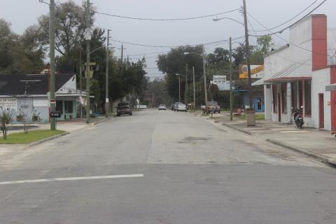
5 Existing Conditions Inventory and Analysis PP Water and wastewater infrastructure owned and operated by the City of Hawthorne is available throughout the visioning study area. The City has funding to replace approximately 20,000 linear feet of the original water lines installed in the 1950 s to create a new 12-inch loop. The improvements to the water system will take approximately 24 months to complete. Currently, the City is replacing the water lines along Johnson Street as part of this project. As many of the water lines are located under the existing sidewalks along Johnson Street, sidewalk improvements will also be completed as part of this infrastructure enhancement project. The City s wastewater system has adequate capacity to handle growth and redevelopment in the visioning area. The City s wastewater treatment facility is currently operating at approximately 60%. FDOT recently reconfigured the SR 20 / US 301 interchange, which includes off-ramps to allow access to S Johnson Street. A sidewalk is located along the roadway section that connects S Johnson Street with SE 62nd Lane. Landscaping has been provided within the interchange right-of-way. The southwest portion of this rightof-way was remediated and is now landscaped. S Johnson Street begins at the SR 20 east-bound off ramp. FDOT resurfaced the intersection for approximately 100 feet (100 ), and includes a dedicated right turn lane. FDOT has plans to repave the entire S Johnson Street corridor. Currently, the roadway has faded pavement markings, as well as some cracking, pot holes, and subpar patching. Lanes are approximately 12 -wide and include on-street parking on both sides. A 5 sidewalk starts at the off ramp on the west side of S Johnson Street, and a 5 sidewalk begins just north of SE 65th Avenue on the east side of S Johnson Street. Both sides of sidewalk terminate where S Johnson Street is bisected by the railroad tracks at SE 71st Avenue. Overhead power lines run along a similar path as well. Trash cans are located periodically along the corridor. There are no clearly defined crosswalks or traffic calming devices to aid in pedestrian safety. Existing Conditions Inventory and Analysis PP The S Johnson Street corridor consists of a mix of vibrant businesses and vacant old buildings, residences, and vacant lots. The corridor can be divided into three distinct sections, with divisions at SE 67th Avenue and SE 71st Avenue. North of SE 67th Avenue is more heavily treed and buildings have modest setbacks ranging from the back of the sidewalk. The building uses consist of a mix of single-family residences, businesses, and civic uses. Most buildings between SE 67th Avenue and SE 71st Avenue are commercial uses, and are pulled to the back of the sidewalk. There are few street trees. However, pedestrians are shielded from inclement weather by a number of awnings. A number of properties in the area, including The Corner Store, Middleton s Lock & Key, Hawthorne Florist, the former convenient store, and the Buffalo Exchange are all former gasoline/fueling stations. Remediation has been performed on some of the properties, but not all. The corridor south of SE 71st Avenue is rural in character, absent of pedestrian facilities and buildings that address the street. The railroad tracks front the west right-of-way, which reduces potential for street-front buildings that characterize the two northern sections. Agricultural uses comprise the properties west of the railroad tracks. The east side consists of a mix of uses, including a restored church that s been converted into the Hawthorne Historical Museum and Cultural Center, the new Hawthorne fire station, a vacant cementblock building, and the converted motel. Although there are few parcels along this corridor, they are in varying states of repair and utility. For instance, the museum is a beautifully restored church, the fire station is a new state-of-the-art facility, and the converted motel is a derelict property in need of clean-up and major renovation.
 to enjoy the shops and amenities along the S")


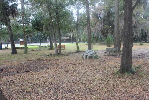
6 PP PP Existing Conditions Inventory and Analysis FDOT Resurfacing Project FDOT is also planning to widen SE 71st Avenue by four feet and adding a bike lane. This will allow bicyclists that utilize the Gainesville-Hawthorne Rail-Trail (located approximately two blocks west of S Johnson Street on SE 71st Avenue) to enjoy the shops and amenities along the S Johnson Street corridor. The planned improvements will allow bicyclists to travel within on-street bike lanes to SR 20. The following civic uses are located within the Vision Plan area. These uses are an asset to the community as they provide opportunities for entertainment, education, and enrichment programs and have also been used as event areas: Hawthorne City Hall; Hawthorne Historical Museum and Cultural Center; and Alachua County Library, Hawthorne Branch. in the past The back yard of City Hall has been used as a collection point for Keep Alachua Beautiful trash pickups and a location for food distribution for charities. In the past, the Hawthorne Museum property has been used as a farmer s market. And The City uses S Johnson Street and sidewalks from SE 71st Avenue to SE 65th Avenue for the Christmas parade. The entire route is shut down for the festival. Vendors, arts & crafts, along with the parade, utilize the route. The private lot across from City Hall at the corner of SE 67th Avenue and S Johnson Street is used as a kiddie play area during the festival with games, bounce houses, rock climbing, etc. The 83rd annual Hawthorne Homecoming event is usually located on SE 65th Avenue. Starting this year, the event will take place on S Johnson Street with the parade route and possible car show. Only The wooded area behind the museum is the prime public space that can be used as open space or a park within the Vision Plan area. The site currently has a couple of benches that can be used for relaxation. The Gainesville-Hawthorne Rail-Trail, which provides hiking, biking, and horseback riding opportunities, is located just outside the Vision Plan area. Currently This inventory and analysis provides an overview of the Historic Johnson Street Downtown Vision Plan area and provides a basis from which to begin the visioning process. This process will help the City of Hawthorne plan for growth and redevelopment that is consistent with the City s Comprehensive Plan, Community Redevelopment Plan, and stakeholders needs and desires for their community. Public Historic Features and Preservation Activities Murals are used to remind residents and guests of the City s historic background while creating a sense of place and adding to the inherent beauty of the downtown. Murals allow the history of Hawthorne to become a visual part of the downtown experience. The emphasis on the City s unique character will revitalize the city and stimulate commerce. Beautiful buildings will encourage people to come to downtown to shop, eat and enjoy the historic City of Hawthorne. These murals should be accompanied by small signs explaining the significance of the buildings and the scenes depicted in the murals. A few examples of buildings which could benefit from the addition of murals are the old post office building and the historic bank. Is Preservation of the City s historic Florida landscape can be emphasized through new landscaping initiatives. Native plants should be used in landscaping to emphasize the natural Florida landscape. The plants should be drought resistant and able to withstand heat and cold. Irrigation for public landscaping is not available along Johnson Street, creating a need for native, low-maintenance foliage. The community can also be involved in maintaining the green space; businesses and residents can help irrigate the plants during dry times to help create a sense of community and togetherness. To figure out where they are Precedence Improved signage will make it easy for visitors to identify opportunities. This is a crucial part of establishing the identity of the area and can help establish the historical significance for some of the roadways. In addition, way-finding signage can help provide direction for visitors and make the downtown more user friendly. a friendlier place to be a part of


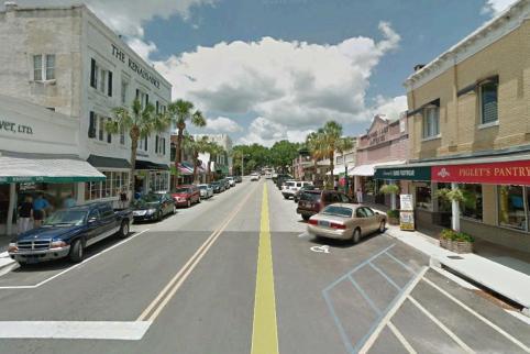
7 existing and programmed infrastructure, utility conditions, and existing transportation and pedestrian conditions. Workshop & Visual Preference Survey WS The first step in the visioning process was the existing conditions inventory and analysis, as outlined above. This assessment diagrams the streetscapes, parks, open space, and event areas within the historic Johnson Street area. In addition, this analysis reviews existing infrastructure, utility, transportation, and pedestrian conditions, as well as programmed improvements. This analysis serves as an introductory statement to the infrastructure needs and the transportation needs of the downtown area. The next step in the process was the visioning workshop and visual preference survey. The workshop participants were asked to score a series of pictures on a scale from 1 to 5, one being the least desirable and 5 being the most desirable. The pictures were grouped into the following categories: highway retail, highway signage, local retail, streetscape, landscaping, public spaces, lighting, and community entrance signage. The objective of this workshop was to identify objectives and key issues for the Historic Johnson Street area, identify improvements to the streetscapes that may include landscaping, sign regulation and control, entrance features, intersection treatment and lighting, as well as clean-up and improvements to private property along the streets, and to identify opportunities and constraints. Elements Highway Retail The category was selected because the study area includes the existing Hawthorne Square shopping center on US 301, north of SR 20. The image of the existing shopping center scored the lowest in this category. The aerial of the typical highway shopping center development pattern scored second lowest. However, a ground level photo of the same shopping center as shown in the aerial, tied for first. The landscaping and higher quality building façades are likely reasons why this image scored so high. The other image that tied for first shows a shopping center development pattern that includes buildings placed closer to the street. Highway Signage Again, this category was incorporated due to the inclusion of the Hawthorne Square shopping center in the study area. As expected, the image of uncontrolled signage along a highway received the lowest score. The existing Hawthorne Square signage received the second lowest score. The existing CVS sign in the Hawthorne Square shopping center received the second highest score. The highway signage image with a brick base received the highest score. The scores in this section indicate that participants want to see higher design standards for signage along US 301 in the study area. Local Retail WS This category was intended to capture participants scale and design preferences for local retail along Historic Johnson Street. Most images were taken from surrounding communities in north central Florida. While all images received favorable scores, the highest scoring image was from the City of Alachua s downtown / Main Street. Streetscape The image of the existing Historic Johnson Street streetscape by-far received the lowest score. The other three images all received higher scores. Again, the image receiving the highest score was from the City of Alachua s downtown / Main Street area.


8 Elements WS Elements WS Landscaping Lighting The image emphasizing native landscaping materials received the highest score. The image demonstrating the use of low impact development (LID) techniques from Innovation Square in Gainesville, FL received the second highest score. Even though the workshop participants spoke negatively of the existing landscaping at the SR 20 / US 301 intersection, the image received a moderately high score. The image of the existing Hawthorne street lights received the lowest score. Images from the City of Alachua and Siesta Key received the highest scores. These scores indicate that the workshop participants prefer more pedestrian scale lighting that incorporates consistent architectural features and elements. Public Spaces The first three (3) images in this section all received high scores. These images included basketball courts, the existing park area adjacent to the Hawthorne Historical Museum, and an urban park along the City of Alachua s Main Street. Again, the image from the City of Alachua received the highest score. These scores indicate that a variety of open / public spaces are desired for the downtown area. Community Entrance Signage The scores for these images indicate that participants prefer signage that incorporates natural materials, i.e. wood and/or stone, and has a rustic feel but is neither too basic nor too elaborate. Conclusions The results of the Visual Preference Survey are consistent with the workshop participants identification of opportunities and constraints and the overall discussions about the study area. In general, the images of existing conditions in the Hawthorne study area received the lowest scores, indicating a need and desire for change. Another pattern that emerged from the survey results is that the City of Alachua can serve as a good model and resource for the City of Hawthorne s potential improvements.


9 Workshop Results WR WS The overall objective established by the participants is to create an environment that attracts more residents and visitors from the Gainesville Hawthorne State Trail, SR 20, and US 301 to the Historic Johnson Street area. In turn, this will create a thriving business district and enhance Hawthorne s sense of community and pride. The participants felt that more could be done to attract cyclists utilizing the Gainesville Hawthorne State Trail. Updated information and additional way-finding signage or kiosks could be placed at the trail head to inform users about businesses in Hawthorne. Additionally, bike racks should be installed along Historic Johnson Street to make cyclist feel more welcome and encourage them to spend time in the study area. The workshop participants identified poor accessibility from SR 20 and US 301 as a key constraint for revitalizing the Historic Johnson Street area. Therefore, additional signage along these roadways is necessary to direct traffic into the study area. The participants also identified an opportunity to establish a gateway or primary entrance into the study area from US 301 at 69th Avenue. The addition of pedestrian street lights, landscaping, and street furniture will make visitors feel more comfortable, especially at night, in the downtown area. Infrastructure improvements were identified to assist the growth of existing businesses and help attract new businesses to the Historic Johnson Street area. The need for high-speed internet was seen as the most important improvement for businesses. Opportunities & Constraints At the Public Visioning Workshop held on March 2, 2015, the attendees participated in an Opportunities and Constraints break-out session. The two (2) groups used an aerial map to mark on and help identify potential opportunities and constraints to redevelopment within the study area. Following the breakout exercise, each group presented their ides to the entire group. As a result of further analysis, these opportunities and constraints can be broken into six (6) categories, as diagrammed out below. Each of these categories contains a series of initiatives drawn from the breakout exercise. These initiatives are intended to meet the goals of the Historic Johnson Street Downtown Vision Plan. Below is a bulleted list of objectives and constraints, organized into each category. Circulation Elements: Roads Street Names The street naming convention needs to be updated to use both the numeric 911 and the historic street name in order to reduce confusion and connect with the historic character of the downtown. Repaving The southern end of the FDOT repaving limits need to be modified to take in the museum. Street Parking There is a need for additional street parking to encourage drivers to stop and use the downtown amenities. Limited right-of-way width along Johnson St. Circulation Elements: Bicycles and Pedestrians Shared Lanes Roads will be shared with bicycles. This helps to emphasize slow moving traffic for pedestrian and bicycle safety, which can also help facilitate economic growth by allowing more people to stop and enjoy the downtown area rather than simply drive through it. WR OC Crosswalk infrastructure More crosswalks will help in slowing traffic down while allowing pedestrians to feel safe and welcome. Slowing cars down also encourages more bicycle traffic. Bike Racks Provide bike racks at various points in the downtown and along Johnson Street to invite cyclists and create a bike-friendly atmosphere. Encourage Pedestrian Safety Updated lighting to ensure pedestrian safety at night. People like to visit places where they feel safe and welcome. Proper lighting can ensure that people will want to visit the downtown at night. Pedestrian Amenities Benches give people a place to stop and rest while shopping. This is also a critical step in making a more pedestrianfriendly environment. Currently, there are also no public restrooms in the downtown area. Addition of public restrooms also will aid in the creation of a pedestrian-friendly environment.


10 WR OC WR OC Opportunities & Constraints Beauty and History ȃ ȃ Utilize Local Historic Society Murals Several murals already exist in the area. These help to remind residents and guests of the City s history while creating a sense of place and adding to the inherent beauty of the place. Murals can be used to add to the visual experience and help revitalize the town and stimulate commerce. Adopt- a-block Program As a predominantly rural community located near an urban cluster, Hawthorne is at a disadvantage for grant funding opportunities. Adopt-a-Block can help to fund some of these beautification and redevelopment efforts. Building Theme Incorporate architectural guidelines in the CRA area and utilize the Historic Hawthorne Apartments to establish the theme. Incorporate other historic buildings into the theme as well. other Blight Removal Some buildings are in poor condition and should be removed or revitalized. Deserted buildings are detrimental to businesses and economic advancement. Hold a competition to paint fire hydrants in Hawthorne a lowcost solution to create a vibrant streetscape. Better promote the existing Façade Improvement program Signage and Linkages Way-Finding Signage Provide way-finding signage to Historic Johnson Street along SR 20 and US 301 to attract travelers to the downtown. Additionally, provide way-finding signs from the Gainesville Hawthorne State Trail (GHST) to downtown. These signs will direct visitors to downtown shops, city offices, museum, and the library. Information Kiosk Provide an information kiosk at the GHST to welcome and encourage cyclists to stay and visit downtown. Linkages and Gateways Connect GHST to Little Orange Creek Park with a route that goes through downtown. Additional gateways can be created at the north and south end of Johnson St. and from US 301 at 69th Ave. Expand FDOT bike trail signage public currently Opportunities & Constraints Landscaping and Green Space Native plants should be used in landscaping to emphasize the natural Florida landscape. The plants should be drought resistant and able to withstand heat and cold. Irrigation for public landscaping is not currently available along Johnson St. There is a need for native, low-maintenance foliage. The community can also be involved in maintaining the green space. Cease landscaping on SR 20 overpass Resources can be better utilized elsewhere. Green Space Plan for the integration of green space, which can create visual landmarks and allow people to connect with the Florida natural landscape. This is especially necessary in the southernmost portion of the site, where street trees have all but vanished. Economic Development Strategies Utilize existing infrastructure at the telephone switching station to provide high-speed internet and create downtown Wi-Fi. Lands are available for a civic center. Maintain an existing mix of uses in the downtown area. Unify municipal websites


11 Conclusions & Rendering C & Rendering Based on the FDOT repaving plans and the input received from the Visioning Workshop participants, a sketch-up of potential streetscape improvements was prepared for a portion of Historic Johnson Street. The FDOT repaving project will create a serpentine alignment for Historic Johnson Street. Currently the street s centerline is a straight shot with parallel parking along certain areas. The serpentine roadway alignment will create opportunities for landscape islands, C angled parking on alternating sides of the roadway, act as a traffic calming device, and create visual interest along the multi-modal transportation route. Another major improvement shown in the enhanced streetscape is the relocation of overhead utility lines. This could either be done by placing the utility lines underground or by relocating them to the back of buildings fronting Historic Johnson Street. This will be a very expensive endeavor, and funding sources will need to be explored and identified. The enhanced streetscape also incorporates many of the workshop s recommended improvements, including street trees and landscaping, bike racks, benches, and pedestrian lighting. A pedestrian crosswalk is also highlighted in the enhanced streetscape. Using an alternate material or marking for the crosswalk helps create a more pedestrian friendly environment. Circulation elements in the downtown area are in vital need of redevelopment. As it stands now, the roadways need repaving, accessible parking is scarce, and alternative forms of transportation need to be considered. existing conditions The roadway South of SR 20 requires resurfacing at a minimum. As the road continues south, building setbacks become smaller and eventually disappear entirely. In the southernmost portion of the site, street trees are also virtually nonexistent. Street parking is traded in for building rear-side parking on specific areas of the street, making on-street parking access difficult. There is a need for bicycle mobility and safety on the streetscape. Johnson Street will be converted into a shared street so bicycles can ride on the same street as cars. This, in addition to the implementation of bike racks and a linkage to the Gainesville Hawthorne State Trail, presents efforts to improve bicycle friendliness in the downtown area. There is also a need for pedestrian circulation on Johnson Street. Efforts to increase pedestrian activity include improvement of crosswalks, lighting, and restrooms. Increasing pedestrian activity in the downtown area is a vital component to the overall goal of increased economic development and future growth. latrines potential improvements


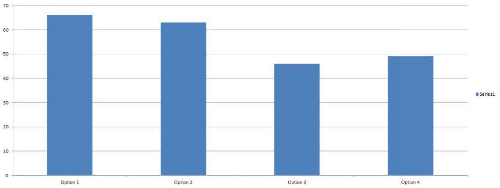
12 A Appendix A highway retail A Appendix A highway signage option 4 option 1 option 2 option 2 option 3 option 1 option 3 option 5 option 4


13 A Appendix A local retail A Appendix A streetscape option 1 option 2 option 1 option 2 option 4 option 3 option 3 option 4


14 A Appendix A landscape A Appendix A public spaces option 1 option 3 option 1 option 2 option 2 option 4 option 3 option 4


15 A Appendix A lighting A Appendix A community entrance signage option 1 option 2 option 2 option 1 option 3 option 3 option 4 option 4

16
17 I City of Hawthorne Historic Johnson Street Vision Plan A Strategy for Economic Revitalization Study and Vision Plan Developed by the City of Hawthorne CHW Professional Consultants
Hockessin Community Redevelopment Plan
 Hockessin Community Redevelopment Plan 3.1 Introduction The Community Redevelopment Plan for the Village of Hockessin is the result of the people s vision for a distinct village center that serves as the
Town Center (part of the Comprehensive Plan)
") Town Center (part of the Comprehensive Plan) Mercer Island Town Center Looking North (2014) In 1994, a year-long process culminated in a set of design guidelines and code requirements for the Town Center
Town Center (part of the Comprehensive Plan) Mercer Island Town Center Looking North (2014) In 1994, a year-long process culminated in a set of design guidelines and code requirements for the Town Center
Potential Green Infrastructure Strategies May 6, 2015 Workshop
 Potential Green Infrastructure Strategies May 6, 2015 Workshop Background The City of Cortland is developing the Tioughnioga Urban Headwaters Green Infrastructure Action Plan with funding from the National
The Lower SaLuda Greenway
 The Lower SaLuda Greenway InITIaTIve a FLourIShInG Greenway. a hub For economic GrowTh. a ConneCTIon BeTween CoMMunITIeS. In April 2017 the Michael J. Mungo Foundation and Lexington County commissioned
A Vibrant Downtown. Chapter 5 Cary Public Art Opportunities 31
 A Vibrant Downtown Cary s vision for Downtown is a unique, vibrant, dynamic, pedestrian friendly location; a regional destination and a place to live, work, and recreate, according to the 2001 Town Center
City of Farmington. Downtown Plan. Amendment to the 1998 Master Plan Adopted October 11, 2004
 City of Farmington Amendment to the 1998 Master Plan Adopted October 11, 2004 Introduction Planning Background 1 Scope and Components of the Plan Amendment 2 Concept Introduction 3 Plan Concepts 3 Conceptual
The Vision. Photo provided by The Minervini Group. 46 Vision, Objectives & Strategies
 Vision, Objectives & Strategies The is the public framework and guide for future development of the Grand Traverse Commons. The establishes public polices for infrastructure, the preservation of natural
New York Avenue Streetscape and Trail Project Public Meeting #1 Summary
 New York Avenue Streetscape and Trail Project Public Meeting #1 Summary I. King Jordan Student Academic Center (SAC) Gallaudet University, Washington, DC February 23, 2017 Table of Contents 1.0 Introduction...
LUNDY S LANE COMMUNITY IMPROVEMENT PLAN STUDY
 PUBLIC INFORMATION MEETING #2 October 12, 2016 LUNDY S LANE COMMUNITY IMPROVEMENT PLAN STUDY AGENDA 5:00 to 5:30pm: Open House 5:30 to 6:15pm: Presentation 6:15 to 7:00pm: Individual paced workshop with
The transportation system in a community is an
 7 TRANSPORTATION The transportation system in a community is an important factor contributing to the quality of life of the residents. Without a sound transportation system to bring both goods and patrons
V. Vision and Guiding Principles
 V. Vision and Guiding Principles The Master Plan for the Powers Ferry Corridor seeks a foundation in the desires of the community. At times, various elements of the community offered opposing viewpoints,
Planning Districts INTRODUCTION
 INTRODUCTION To facilitate detailed examination of development prospects for all areas of the community, Delano has been divided into 14 planning districts. The location of these planning districts is
Table of Contents. Elm Avenue Improvement Plan City of Waco, Texas. Introduction 1. Existing Context 1 Figure 1 2.
 Table of Contents Introduction 1 Existing Context 1 Figure 1 2 Plan Guidelines 3 Future Urban Form 4 The West-End 4 Main Street 6 The East-End 7 Figure 2 9 Public Improvement Recommendations 7 General
In surveys, Dallas residents say what they want to change most
 NEIGHBORHOODS ELEMENT In surveys, Dallas residents say what they want to change most in the city is its appearance they want it to look beautiful, with trees and pedestrian-friendly neighborhoods. The
Policies and Code Intent Sections Related to Town Center
 Policies and Code Intent Sections Related to Town Center The Town Center Vision is scattered throughout the Comprehensive Plan, development code and the 1994 Town Center Plan. What follows are sections
4- PA - LD - LIVELY DOWNTOWN. LD - Background
 4- PA - LD - LIVELY DOWNTOWN LD - Background The downtown has been the service centre for the community since the city s inception and the area continues to supply people with their personal services,
Roanoke Rapids Streetscape Master Plan. City Council Presentation
 SCHEDULE: Stakeholder Meeting/Kick off November,2016 Master Planning Phase (November March 2017) Public Meeting #1 December 13, 2016 Review Meeting with Key Stakeholders Refine Concepts Based on Input
Public input has been an important part of the plan development process.
 Lakewood s Comprehensive Plan recognizes that transportation helps shape the community, and that the way the community provides for the safe and efficient movement of people affects the character of the
EXISTING COMPREHENSIVE PLAN
 EXISTING COMPREHENSIVE PLAN Town Center Land Use Element: V. LAND USE POLICIES Town Center Mercer Island's business district vision as described in "Your Mercer Island Citizen-Designed Downtown" was an
CHAPTER 3 VISION, GOALS, & PLANNING PRINCIPLES. City of Greensburg Comprehensive Plan. Introduction. Vision Statement. Growth Management Goals.
 CHAPTER 3 VISION, GOALS, & PLANNING PRINCIPLES Introduction The Greensburg Comprehensive Plan is intended as a working community document. A combination of long and short-term goals, this document is intended
West Ocala Vision & Community Plan City Council Work Session. Presented by West Ocala Community Plan Steering Committee
 West Ocala Vision & Community Plan City Council Work Session Presented by West Ocala Community Plan Steering Committee November 29,2011 Ocala 2035 Vision West Ocala Community Vision & Master Plan West
New-Cast Mixed-use Development Proposal King Street West, Newcastle, Ontario
 URBAN DESIGN BRIEF New-Cast Mixed-use Development Proposal King Street West, Newcastle, Ontario TABLE OF CONTENTS: 1.0 Executive Summary 2.0 Creating Vibrant and Sustainable Urban Places: Excerpts from
Transportation. Strategies for Action
 Transportation A major priority for the Overlake Neighborhood is to develop a multimodal transportation system. To achieve this system, a balance has to be found among travel, circulation and access needs;
Urban Design 9Identity
 Urban Design 9Identity URBAN DESIGN IDENTITY Urban design is about connecting people to their places through the built environment, nature, and overall urban form. Done well, it creates a memorable space
BUILDING SCALE AND SETBACKS 5 ELEMENTS:... 5 FAÇADES (COMMERCIAL/RESIDENTIAL) 5
 5") VISION STATEMENT 3 UTILIZATION OF THE GUIDELINES 3 IMPLEMENTATION 3 PROCEDURES FOR DESIGN REVIEW 3 LAND USE AND ZONING 4 LAND USE 4 ELEMENTS:... 4 ZONING 4 ELEMENTS:... 4 BUILDING SCALE AND SETBACKS 5
VISION STATEMENT 3 UTILIZATION OF THE GUIDELINES 3 IMPLEMENTATION 3 PROCEDURES FOR DESIGN REVIEW 3 LAND USE AND ZONING 4 LAND USE 4 ELEMENTS:... 4 ZONING 4 ELEMENTS:... 4 BUILDING SCALE AND SETBACKS 5
Downtown Streetscape Manual & Built Form Standards
 City of Guelph Downtown Streetscape Manual & Built Form Standards July 2014 Prepared by Brook McIlroy Inc. in association with Unterman McPhail Associates and McCormick Rankin Inc. City of Guelph Downtown
COMPLETE GREEN STREET CHECKLIST
 COMPLETE GREEN STREET CHECKLIST This document was developed to dissect the structure of an urban street and explore opportunities to make our streets more complete while also integrating green street strategies.
Northwest Rail Corridor and US 36 BRT Development Oriented Transit Analysis 4.4 STATION AREA FINDINGS
 4.4 STATION AREA FINDINGS Each station is different, and each one requires a separate set of recommendations based on the vision for the site. This section outlines an initial TOD strategy and recommendations
DRAFT ROOSEVELT ROAD. District Recommendations. Figure 5.23 The Roosevelt Road Corridor
 CHAPTER 5 Figure 5.23 The Road Corridor Road will develop as a mixed-use corridor, emphasizing regional retail, west of the river and mixed-use development east of the river. KEY RECOMMENDATIONS 1. High
FUTURE LAND USE ELEMENT
 FUTURE LAND USE ELEMENT GOAL I: To create and sustain a great place to live, play, and prosper Objective 1: The City of Ocala shall incorporate the principles and strategies of the Ocala 2035 Vision into
CHAPTER 7: VISION AND ACTION STATEMENTS. Noble 2025 Vision Statement
 CHAPTER 7: VISION AND ACTION STATEMENTS This chapter presents the vision, policy and action statements that transform the comprehensive planning study, an analysis of Noble s past, future trends and community
Regency Developments. Urban Design Brief. Holyrood DC2 Rezoning
 Regency Developments Urban Design Brief Holyrood DC2 Rezoning Stantec Consulting Ltd. 7-31-2017 1. Overview Regency Developments intends to rezone the lands located at 8510 and 8511 93 Avenue, within the
Welcome. Walk Around. Talk to Us. Write Down Your Comments
 Welcome This is an information meeting introducing the applications for proposed redevelopment of the Yorkdale Shopping Centre site at 3401 Dufferin Street and 1 Yorkdale Road over the next 20+ years,
PIKE PINE RENAISSANCE: ACT ONE. October 19, 2017
 PIKE PINE RENAISSANCE: ACT ONE October 19, 2017 WATERFRONT SEATTLE PROGRAM PROJECT INTRODUCTION Pike and Pine streets, between First and Melrose avenues Pedestrian and streetscape improvements Budget:
Draft Memorandum #1: Goals and Vision for Revitalization
 Keizer Revitalization Plan Draft Memorandum #1: Goals and Vision for Revitalization Submitted to: City of Keizer April 12, 2018 (revised) Prepared By: Angelo Planning Group and Otak, Inc. Project No. 17482.A
section five BEAUTIFICATION PLAN
 section five BEAUTIFICATION PLAN BEAUTIFICATION PLAN Section Five Beautification Plan The goal of the Beautification Plan is to improve the Route 8-Sunnyland Corridor in terms of aesthetics and to create
This Review Is Divided Into Two Phases:
 Semiahmoo Town Centre Review The purpose of this review: To review the Semiahmoo Town Centre Concept Plan, originally approved in 1993, to ensure that this centre will continue to serve the needs of South
7Page 91 CLEMMONS COMMUNITY COMPASS 7 COMMUNITY CHARACTER
 7 Community Character The beauty of Clemmons won t necessarily be a reflection of our past, but our future. This quote from Comprehensive Plan Steering Committee member Wayne Dodson captures the essence
DRAFT Subject to Modifications
 TREASURE COAST REGIONAL PLANNING COUNCIL M E M O R A N D U M To: Council Members AGENDA ITEM 8 From: Date: Subject: Staff May 19, 2017 Council Meeting Florida Department of Transportation Complete Streets
Project Goal. RRRC Living Towns Planning Workshp. Town of Halifax Revitalization Project. Dynamic Planning & Management Duo: July 12, 2006
 Project Goal Town of Halifax Revitalization Project RRRC Living Towns Planning Workshp July 12, 2006 Town of Halifax Halifax County *** Revitalization Project Goal*** To create Economic Opportunity and
Illustration of Eastlake Farmer s Cooperative Grain Elevator. Chapter 5: implementation 5-1
 Illustration of Eastlake Farmer s Cooperative Grain Elevator Chapter 5: implementation 5-1 chapter 5: implementation Introduction The Eastlake Subarea Plan includes a wide range of recommendations intended
Baraga Avenue PlacePlan Marquette, MI July 24 th, 2014
 Baraga Avenue PlacePlan Marquette, MI July 24 th, 2014 Presentation Outline Project Purpose Acknowledgements Placemaking Overview PlacePlan Process Design Overview PlacePlan Recommendations Physical Design
3. STRATEGY FOR NEIGHBORHOOD SUSTAINABILITY
 3. STRATEGY FOR NEIGHBORHOOD SUSTAINABILITY This neighborhood plan focuses on assuring that Government Hill retains a high degree of sustainability, in that it conserves built resources that are part of
RESEDA - WEST VAN NUYS COMMUNITY PLAN
 RESEDA - WEST VAN NUYS COMMUNITY PLAN Executive Summary As part of the initial outreach effort, the Department of City Planning hosted two workshops for the Reseda-West Van Nuys Community Plan Area during
FDOT D4 Complete Streets
 FDOT D4 Complete Streets Context Sensitive Solutions Directs that complete street solutions will complement the context of the community. Collaborative approach to decision making, project development,
City of Hermosa Beach Administrative Policy #
 City of Hermosa Beach Administrative Policy # SUBJECT: Living Streets Policy Date: Approved by: City Council Authority: Public Works Department & Community Development Department Mayor, PURPOSE The City
Dyersville Downtown Plan. Open House October 24, 2017
 Dyersville Downtown Plan Open House October 24, 2017 What is a Comprehensive Plan? - Vision - Guidance for decisions - Basis for regulations What is a Downtown Plan? - Understand priorities - Identify
The Auburn Plan Designing the Future of Auburn February 28, 2005
 The Auburn Plan Designing the Future of Auburn February 28, 2005 Block-by-Block Bicycle Tour Aerial survey Focus Group Meetings September 7 and 8 Design Workshops October 11, 14, and 21 Revitalization
Olde Towne Vision Plan
 Olde Towne Vision Plan Introduction In 2016, the City of Bellevue will complete its move of City offices from Olde Towne Bellevue to its new municipal complex on Wall Street. The City intends to sell its
4. INDUSTRIAL 53 CASTLE ROCK DESIGN
 4. INDUSTRIAL 53 CASTLE ROCK DESIGN CASTLE ROCK DESIGN 54 4. INDUSTRIAL Overview Well-designed and attractive industrial centers are the product of blending economic realities with both functional and
APPENDIX D: Visual and Aesthetic Conditions for NCCU Station Refinement. Durham-Orange Light Rail Transit Project
 APPENDIX D: Visual and Aesthetic Conditions for NCCU Station Refinement Durham-Orange Light Rail Transit Project October 2016 1. Introduction The Combined FEIS/ROD summarizes the effects of the D-O LRT
Downtown Papillion. Concepts for the Enhancement and Growth of Papillion s Traditional Town Center
 Downtown Papillion Concepts for the Enhancement and Growth of Papillion s Traditional Town Center Developed for the City of Papillion by RDG Planning & Design T raditional downtown districts occupy a particular
Community Design Plan
 Gardena General Plan 2006 Authority While the is not a required element of a General Plan, it is included because improving the community appearance and image is paramount to the overall quality of life
A. Background Summary of Existing Challenges and Potential Possibilities. 1. Summary of Existing Assets and Potential Opportunities
 A. Background 1 A Main Street Master Plan Study was performed and completed in October of 2007. The study was initiated to review current land uses and development patterns along Main Street, from Parrish
FRUITVALE TRANSIT VILLAGE (Phase 2) Residential Project
 Residential Project") FRUITVALE TRANSIT VILLAGE (Phase 2) Residential Project DEVELOPER: SIGNATURE PROPERTIES ARCHITECT: HKIT ARCHITECTS April 23, 2010 TABLE OF CONTENTS 3 Vision 4 Description of Site 5 Guiding Concepts 6
FRUITVALE TRANSIT VILLAGE (Phase 2) Residential Project DEVELOPER: SIGNATURE PROPERTIES ARCHITECT: HKIT ARCHITECTS April 23, 2010 TABLE OF CONTENTS 3 Vision 4 Description of Site 5 Guiding Concepts 6
4.1.3 LAND USE CATEGORIES
 4.1.3 LAND USE CATEGORIES a. City Center District The City Center District incorporates the existing character and mix of uses in downtown Belmont to encourage redevelopment and new development in keeping
Small Area Plan. South Gateway
 Small Area Plan Adopted May 12, 2008 South Gateway Purpose. The South Gateway Small Area Plan defines the City s expectations for the future of the southern entrance to the City at Interstate 85 and Highway
Vision Plan Kickoff Meeting Summary Report
 Vision Plan Kickoff Meeting Summary Report October 2018 The Vision Plan With the redevelopment of the Amtrak Property, Penn Station Partners (PSP) seeks to build on the creative talent and entrepreneurial
Main Street Streetscape Plan. Downtown Redevelopment Plan Phase One
 2012 Main Street Streetscape Plan Downtown Redevelopment Plan Phase One Message from Council Council Left to right: Dwight Ganske, Judy Bennett, Darren Badry, Mayor Ken Lemke, Robert Twerdoclib, Pat Hansard,
Status Update (2006 vs. Now) Citizen s Advisory Committee February Plan for Prosperity
 Citizen s Advisory Committee February Plan for Prosperity") Status Update (2006 vs. Now) Citizen s Advisory Committee February 2018 Plan for Prosperity 2000 2017 2000 2017 Gardnerville Population 6,000 5,760 5746 5,500 5,000 5,067 5,550 5,165 5,394 5,412 5,250
Status Update (2006 vs. Now) Citizen s Advisory Committee February 2018 Plan for Prosperity 2000 2017 2000 2017 Gardnerville Population 6,000 5,760 5746 5,500 5,000 5,067 5,550 5,165 5,394 5,412 5,250
PROTECT AND PROMOTE QUALITY OF LIFE AND LIVABILITY FOR THE CITIZENS OF GAINESVILLE THROUGH QUALITY URBAN DESIGN.
 Goals, & Urban Design Element PROTECT AND PROMOTE QUALITY OF LIFE AND LIVABILITY FOR THE CITIZENS OF GAINESVILLE THROUGH QUALITY URBAN DESIGN. GOAL 1 By 2003, the City shall adopt urban design standards
Corridors. Re-vitalize our Corridors and Gateways
 Corridors Re-vitalize our Corridors and Gateways Artist s rendering from the 287 Strategic Plan, 2015 Corridors are the major throughways of Loveland but they also provide important commercial, community
EXHIBIT A. Tax Increment Reinvestment Zone No. 1 (Town Center) First Amended Project Plan 1
 First Amended Project Plan 1") EXHIBIT A Tax Increment Reinvestment Zone No. 1 (Town Center) First Amended Project Plan 1 1 As amended by Resolution No. 2008-02-001(TR1R) of the Tax Increment Reinvestment Zone No.1, and approved to
EXHIBIT A Tax Increment Reinvestment Zone No. 1 (Town Center) First Amended Project Plan 1 1 As amended by Resolution No. 2008-02-001(TR1R) of the Tax Increment Reinvestment Zone No.1, and approved to
Maplewood Avenue Downtown Complete Street Project
 Maplewood Avenue Downtown Complete Street Project Second Public Meeting January 24, 2018 Welcome and Introduction of Project Team City Planning and Public Works Staff City of Portsmouth Juliet Walker Planning
BROOKHILL NEIGHBORHOOD MODEL ZONING MAP AMENDMENT PREFACE TO APPLICATION
 BROOKHILL NEIGHBORHOOD MODEL ZONING MAP AMENDMENT PREFACE TO APPLICATION June 15, 2015 Revised: August 1, 2016 I. VISION Brookhill is a proposed community based upon the principles of Albemarle County
Fifth and Detroit Street Design May 2017 Capital Improvements Committee. DOWNTOWN Street Design
 1 Fifth and Detroit Street Design May 2017 Capital Improvements Committee Agenda 2 Review Street Configuration Prior Meeting Review Outreach Synopsis Functional Street Design Refinements Curb Edge, Turning
hermitage town center
 hermitage town center A Community Vision prepared by Strada for The City of Hermitage and The Mercer County Regional Planning Commission January 2007 table of contents introduction 3 design principles
City of Plattsburgh DRI: Downtown Streetscapes & Riverfront Access. Downtown Streetscape and Riverfront Access Design
 City of Plattsburgh DRI: Downtown Streetscapes & Riverfront Access Welcome Thank you for coming this evening. Agenda PART I - Project Context The Downtown Revitalization Program Our DRI Projects Other
Downtown Lead Revitalization Project Final Recommendations. Three Proposed Options for the Revitalization of Downtown Lead
 Downtown Lead Revitalization Project Final Recommendations Three Proposed Options for the Revitalization of Downtown Lead November 1, 2011 Three Proposed Options for the Revitalization of Downtown Lead
Implementation Guide Comprehensive Plan City of Allen
 Implementation Guide 2030 Comprehensive Plan City of Allen DRAFT 2015 Implementation Guide Allen 2030 Comprehensive Plan INTRODUCTION The Comprehensive Plan serves as a guide for the growth and development
V. Gateways GATEWAYS / V-1
 V. GATEWAYS / V-1 Many of Chesapeake s gateways are located on highways and call for bold and attractive designs that motorists can understand, appreciate, and enjoy. can also take the form of natural
TRANSPORTATION ELEMENT GOALS, OBJECTIVES, AND POLICIES
 TRANSPORTATION ELEMENT GOALS, OBJECTIVES, AND POLICIES GOAL 2 The City shall provide a safe, convenient, effective, and energy efficient multimodal transportation system which is coordinated with the Future
Project Consulting Team:
 THE DOWNTOWN CHERRYVILLE LAND USE + STREETSCAPE MASTER PLAN WAS FUNDED THROUGH THE GENEROUS DONATIONS OF THE FOLLOWING: The Community Foundation of Gaston County ElectriCities of North Carolina The Cherryville
The University District envisions, in its neighborhood
 Envisioning the University District Link Light Rail in Seattle s neighborhoods CIY OF SEALE CONCEP-LEVEL SAION AREA PLANNING RECOMMENDAION RESOLUION # 30165 EXHIBI L Vision 08.2000 he University District
Figure 3-1: Public Realm Plan
 3 Public Realm Figure 3-1: Public Realm Plan 3.1 Public Realm Concept The public realm concept for the Little Mountain site integrates a clear and accessible movement network with public spaces for social
STREETSCAPE IMPROVEMENTS - RECOMMENDATIONS
 STREETSCAPE IMPROVEMENTS - RECOMMENDATIONS Figure 4.3.1- A map of all of the recommended streetscape improvements. The key component of downtown s public realm, apart from its public spaces, is its street
DOWNTOWN GEORGETOWN PLANNING STUDY
 DOWNTOWN GEORGETOWN PLANNING STUDY Community Workshop #3 Thursday, May 4, 08 The Planning Partnership OVERVIEW OF STUDY, PROCESS & MILESTONES We are here PURPOSE OF THE STUDY To develop a clear vision
Riverwalk Dreams compiled by Thomas P. Healy November 16, 2017
 Riverwalk Dreams compiled by Thomas P. Healy November 16, 2017 1986 Ripple Village Plan: A neighborhood plan developed by the City of Indianapolis Department of Metropolitan Development s Division of Planning
7-PARKS, OPEN SPACE & PUBLIC ART
 7-s, Open Space & Public Art 7-PARKS, OPEN SPACE & PUBLIC ART This chapter provides recommendations for the expansion of new parks, plazas and open space that serve the many user groups targeted for downtown.
Main Street Reconstruction From Ninth Line to Stouffer Street. Town of Whitchurch-Stouffville. Public Information Centre
 Main Street Reconstruction From Ninth Line to Stouffer Street Town of Whitchurch-Stouffville Public Information Centre November 23, 2016 4:30 to 6:00 pm & 7:00 to 8:00 pm 6240 Main Street, Stouffville
Public Meeting March 10 th 2011
 Public Meeting March 10 th 2011 Agenda 6:00-6:15 6:15-7:00 7:00-8:00 8:00-8:30 8:30-9:00 9:00 Welcome and Introductions Presentation» Project Overview» Recap Existing Conditions / Issues & Opportunities»
Danvers High Street I-1 District Study
 Danvers High Street I-1 District Study Presentation of Final Recommendations Planning Board Presentation June 26 th, 2018 1 Introductions Metropolitan Area Planning Council Sam Cleaves AICP, Principal
TRANSPORTATION ELEMENT
 TRANSPORTATION ELEMENT GOAL I: To create and maintain a safe, efficient and aesthetic transportation system that encourages multi-modal transportation and promotes the mobility strategies of the Ocala
Tyvola & Archdale Transit Station Area Plan. May 15, 2008
 Tyvola & Archdale Transit Station Area Plan First Public Meeting May 15, 2008 Presentation Outline 1. Purpose and Process 2. Station Area Overview 3. Plan Recommendations Vision Land Use Transportation
Executive Summary. NY 7 / NY 2 Corridor
 Executive Summary NY 7 / NY 2 Corridor Transportation and Land Use Study December 2005 Prepared for: Town of Colonie Capital District Transportation Committee Prepared by: Introduction: Land use decisions
Streets Vision
 streets 86 2.9 Vision : The Most Prevalent and Important Public Spaces Fixed routes of human travel have served as corridors for commerce and places for human interaction from the earliest trails and foot
CITY OF NORCROSS LILLIAN WEBB PARK REDEVELOPMENT AREAS
 7/2/2016 CITY OF NORCROSS LILLIAN WEBB PARK REDEVELOPMENT AREAS 2016 Potential Development Around Lillian Webb Park The Lillian Webb Park Development Project is located north of Buford Highway; east of
URBAN DESIGN BRIEF. 2136&2148 Trafalgar Road. Town of Oakville
 URBAN DESIGN BRIEF 2136&2148 Trafalgar Road Town of Oakville Prepared By: METROPOLITAN CONSULTING INC For 2500674 Ontario Inc November 2016 TABLE OF CONTENTS Page No. 1.0 Introduction/Description of Subject
Stakeholders Advisory Working Groups (SAWGs) Smart Growth and TOD Land Use (#11) SAWG Meeting
 Smart Growth and TOD Land Use (#11) SAWG Meeting") Presentation - Part II Tappan Zee Bridge/I-287 Corridor Project July 21, 2010 Slide 1. David Kooris (Regional Plan Association) welcomed members of the Land Use Stakeholders Advisory Working Groups (SAWGs)
Presentation - Part II Tappan Zee Bridge/I-287 Corridor Project July 21, 2010 Slide 1. David Kooris (Regional Plan Association) welcomed members of the Land Use Stakeholders Advisory Working Groups (SAWGs)
Table L-1 Summary Action Strategy. Action Item Timing Status Responsible Agency
 CHAPTER 4: CIRCULATION ELEMENT ISSUE #1: MAJOR THOROUFARES AND TRANSPORTATION ROUTES A balanced transportation system for Fontana is provided that meets the mobility needs of current and future residents
ANCHOR TO ANCHOR. Rescale the street to create an iconic boulevard.
 ANCHOR TO ANCHOR Rescale the street to create an iconic boulevard. UR NE ER UV GO NE LA OBJECTIVES 1. Maintain appropriate traffic flow and prioritize commercial curb access 2. Mark gateways at the street
Today Land & People. Northeast Nampa Gateway District. Employment. Land Use Characteristics. Demographics. Current Zoning
 Today Land & People Employment Major employers include Saint Alphonsus, the College of Western Idaho, the Auto Mall, Sorrento Lactalis and Walmart. 3,004 jobs in 2010 (COMPASS-CIM 2040 TAZ data) 4,345
Zoning Code Issues Prioritization
 City of Streetsboro The City of Streetsboro has begun the process of updating its Zoning Code. The new Zoning Code will be based on the recently adopted Comprehensive Plan, which establishes the overall
Tonight s Agenda. Summary Presentation Open House. Group Discussion Next Steps: online community wide survey
 Community Open House February 22, 2018 Tonight s Agenda Summary Presentation Open House Station 1: Project Overview and Community Input Station 2: Draft Vision and Guiding Principles Station 3: Western,
Table of Contents. Planting of Trees and Grasses. Purpose. Research approach. Downtown District. Findings. Decorative Antique Lighting
 Community Redevelopment Authority 2017 Table of Contents Purpose Research approach Downtown District Findings Planting of Trees and Grasses Decorative Antique Lighting Pedestrian Services Cracked Sidewalks
Master Plan Visioning #1 Section 3 Informal amphitheater at Community Development Services Building. Section 3 MP Visioning #1
 Section 3 Informal amphitheater at Community Development Services Building Section 3 MP Visioning #1 THIS PAGE INTENTIONALLY LEFT BLANK. appendix As with the master planning of any government campus, the
Downtown Huntersville in 2030
 Downtown Huntersville in 2030 In 2030 Huntersville s Downtown will be a thriving, mixed-use town center with a variety of housing types (single-family, townhomes, live-work, and apartments), retail establishments,
Downtown Whitby Action Plan
 Downtown Whitby Action Plan Final Report October 2016 Table of Contents Introduction 1 Public Consultation 2 Walkability 3 Downtown Whitby Walkability Map 4 Vision 5 Goal & Objectives 6 Objective 1 7 Objective
WELCOME and introduction
 1 WELCOME and introduction Mobility Hub Locations within Burlington STUDY OVERVIEW STUDY OBJECTIVES The City of Burlington is developing four Area Specific Plans, one for each of Burlington s Mobility
Complete Neighbourhood Guidelines Review Tool
 Complete Neighbourhood Guidelines Review Tool Prepared By: City of Regina Planning Department October 2014 Page 1 of 14 Community Development Review Checklist for Secondary Plans and Concept Plans The