WINDING HILLS PARK. Upper Allen Township
|
|
|
- Teresa Davis
- 5 years ago
- Views:
Transcription


1 WINDING HILLS PARK Upper Allen Township Master Site Plan August 2015

2 Acknowledgments WINDING HILLS EAST PARK STUDY COMMITTEE Name Paul Rigney Ginnie Anderson Scott Fraser Scott Shepler Scott Steffan Charles Grew John Strohm Gary Gabriel Steve Layton Michael Hassett Amy Cook Tonya Brown Dennis Auker Morgan Cupp Organization Commissioner Commissioner Assistant Township Manager Assistant Public Works Director Upper Allen Baseball Mechanicsburg Area Soccer Mechanicsburg Area Softball Cumberland County Sunday Softball Mechanicsburg Area Youth Lacrosse P&R Board Member P&R Board Member Recreation Director Resident/Environmentalist Student/User of Park Table of Contents Funding for this Master Plan Provided By Upper Allen Township Master Planning / Landscape Architecture / Engineering Services Johnson, Mirmiran and Thompson, Inc. 220 St. Charles Way, Suite 200 York, Pennsylvania Project No C.S.Davidson, Inc. 50 West Middle Street Gettysburg, PA Planning the Park 2 Park Goals and Needs Assessment 3 Inventory and Site Analysis 4 Alternate Designs 5 Park Master Site Plan 6 Phasing and Implementation Appendix A - Applying Sustainability and Green Design Appendix B - Pennsylvania Natural Diversity Inventory (PNDI) Report Appendix C - Topographic Survey


3 1 PLANNING THE PARK Introduction Upper Allen Township lies at the southeast corner of Cumberland County, Pennsylvania, bordered on the south by York County, to the north by Mechanicsburg, to the west by Monroe Township, and to the east by Lower Allen Township. Upper Allen Township encompasses approximately 13.3 square miles, and is a growing suburban community with 132 acres of parks, 2.5 miles of walking trails, 13 pavilions, 13 playgrounds, 6 baseball fields, 5 basketball courts, 7 soccer fields, and 4 softball fields. It is the desire of the Board of Supervisors of Upper Allen Township to create a community park for the enjoyment of the residents of the Township and the general population. The entire Winding Hills Park complex is approximately 48.4 acres, with the existing park west of Winding Hill Road and east of Winding Hill Road making up 36.3 acres of that total. The Township recently acquired 12.1 acres of undeveloped land directly next to Winding Hills Park East from a local developer in lieu of paying a recreation fee. It is this new addition that is the main focus of the updated park master plan. One of the primary goals of this project is to create a master site plan that integrates with the existing park, while meeting the immediate needs of the community. Winding Hills East Park was developed over time without the benefit of a master plan which now presents the opportunity for focused strategic planning. To achieve this goal, the existing utilization patterns will have to be considered, as well as the established needs of the community. Study Purpose The purpose of this study is to explore options for expanding the community park to meet the growing needs of the community. To develop the master plan, we considered the existing facilities, availability of utilities to the site, site limitations, current users, the park and community site characteristics, adjacent land uses, the adjacent developments, township and regional recreation needs and goals, recreation and leisure trends, and the desires of the community and surrounding neighborhoods. A public participation process was undertaken to gain input from the residents on appropriate park facilities. The process included working with a Project Study Committee, completing interviews with key persons in the community, and holding public meetings. The process emphasized citizen input throughout to develop a relevant master plan that targets the existing and future recreation needs of the Township. Community Profile As outlined in the 2008 Comprehensive Plan for Upper Allen Township, nearly all of Upper Allen Township has been designated as a Rural Landscape. The western portion of the Township along Route 896 has been designated as the Rural Center. Winding Hills East Park is strategically located within the heart of the Rural Center which has been identified for future growth within the township. The following demographic profile was summarized based on information outlined in the 2008 Upper Allen Township Comprehensive Plan. Population Statistics: 2010 Population: 18,059 (a 17.7% increase since 2000) Planning the Park 1
4 Winding Hill East Park Expansion Population Projections: Year Projections Children and Youth (0-17 years) 19.5 percent of the total population Adults (18-24 years) 17.4 percent Adults (25-34 years) 9.9 percent Adults (35-44 years) 11.1 percent Adults (45-64 years) 25.4 percent Adults (65 years and over) 16.7 percent Gender: Female 54.2 percent and male 45.8 percent. Race / Ethnicity: The racial makeup of the Township is 91.6% White, 3.3% African American, 0.1% Native American, 2.3% Asian, 0.0% Pacific Islander, 0.7% from other races, and 2.0% from two or more races. Hispanic or Latino was 2.6% of the population. Median Age: 38.9 Households and Housing: Households with children under age 18: 1,900 or 28.3% Persons per Household: 2.29 Owner Occupied: 74.4 percent Total Housing Units: 7,007 Socio-Economic Characteristics: 2013 Median Household Income: $68,151, higher than the county s average: $60,826, In Poverty: 4.9 percent Education: 4.1% of residents do not have a high school diploma. 42.1% of residents have a bachelor s degree or higher. Of residents 25 years and older: High School Graduates: 32.4% Some College: 15.9% Associates Degree: 5.5% Bachelor s Degree: 26.8% Graduate/Professional Degree: 15.2% Master Planning Process The planning process for Winding Hills East Park Expansion Master Site Plan was designed to create a vision for the park that harnessed the opportunities of the site while respecting the inherent limitations. This process included four parts: Initial Analyses Community Involvement Design Process Final Master Plan 2


5 2 PARK GOALS AND NEEDS ASSESSMENT Public Participation Public participation was a key component of the Winding Hills East Park Expansion master planning process. Public input was gathered by working with the Winding Hills East Park Expansion Project Study Committee, completing key person interviews, and conducting public meetings to gather specific park interests and concerns regarding the park s development. Public meetings were also conducted to solicit public feedback regarding the plan alternatives, implementation plan, the final design, and alternative design. Project Study Committee A Park Project Study Committee was formed to help guide the master planning process and to work with the project design team. On January 15, 2015, the Committee met with the design team to explore the goals for expansion of the park. The group explored the opportunities, facilities, concerns, and issues relating to the development of the park. A brainstorming discussion session was conducted to explore the opportunities and concerns for the park. Feedback was acquired from the committee regarding the park with current uses, future uses, and concerns for redevelopment utilizing a series of related questions. These questions included: a. Who are, and who will be, the primary users of the park? b. What do you like about the existing park? c. What don t you like about the existing park? d. What improvements could be made to the existing park? e. What opportunities exists for expansion of the park, and what new facilities should be developed? f. What are the concerns for expansion of the park? g. If you came back 10 years from now what is the one thing you would like to see happening in the park? The following general comments were provided: a. Winding Hills East Parking is limited and there are minimal opportunities for overflow parking during tournaments. The athletic associations are respectful of the neighbors and parking in the adjacent development. b. Winding Hills East parking is difficult to navigate. c. The park is young and there is a lack of trees and vegetation. d. The power lines are a negative and a limitation to be addressed. e. The park is located on the extreme edge of the township. f. The adjacent 7 acre site south of the park is currently being considered as an area to be developed for municipal composting. g. The site is very windy. h. The existing pavilions are rented on a limited basis compared to those at Friendship Park. i. Although the park areas are separated, the individual areas do not feel isolated. j. Trail widths should be increased to 8 feet to accommodate maintenance vehicles. k. Winding Hill Road bisects the park creating two distance parks Winding Hill West and Winding Hill East Park. The posted speed limit is 40 mph, and as such PennDOT will not approve a pedestrian Park Goals and Needs Assessment 3

6 Winding Hill East Park Expansion crossing. The Township is petitioning to reduce the speed limit to 25 mph in order to accommodate a pedestrian connection between the two parks. l. Restrooms should be considered for the park expansion area. m. The park lacks adequate informational and/or directional signage. n. The existing stormwater basin in the middle of the park is currently functioning as a sediment trap and should have been removed once the area was stabilized. o. The athletic associations have previously met and determined the need for recreation fields within the township. A report documenting the general findings was prepared and will be forwarded to JMT. p. The immediate recreational field needs are: One full size lacrosse field One multi-purpose field One 200 youth baseball field One 11V11 dedicated game soccer field q. The general consensus was that a full size lacrosse field was the top priority. r. It was noted that girls softball is on the decline. The need for additional fields is uncertain. Recent registration fees were waived to encourage more participation. s. Relocation of a full size adult baseball field to the park was suggested and the pros and cons of mixing adult and youth baseball was discussed. t. The lack of indoor gym space in particular basketball courts was noted as a need in comparison to adjacent communities. u. Additional facilities that should be considered in the park expansion: Dog park Splash pad Continuation of the pathways linking new and existing facilities, as well as connections beyond the park. Water fountains Seasonal and winter storage Maintenance garage/storage Picnic facilities with grill stations Youth playground and tot lot Security and parking area lighting Overflow parking v. The township has been utilizing split rail fencing to define the park boundary and control pedestrian and vehicular circulation. w. The layout of the proposed fields should consider proper orientation and safety areas. x. Overlapping fields are not desired. Designated fields are preferred. y. The soccer associations currently use portable lights at Winding Hill Park after mid-october to extend practice times. The township is currently preparing an update to its comprehensive park and open space plan. This plan will address the larger issues facing the township including the need for additional active recreation space and special use facilities such as indoor recreation space, dog parks, and splash pads. While the focus of the master plan is the additional 12 acres recently acquired, the park area should be viewed as one park. Some of the larger design issues at the existing park to address include accessibility, orientation, and general safety concerns. Recommendations will be made as part of the comprehensive park and open space plan. Key Person Interviews The JMT consulting team conducted a series of key person interviews to obtain input regarding the Winding Hills East Park property and the concept of an expansion plan. Information was gathered regarding historical and current data about the property, existing park uses and facilities, and additional facilities people would like as a part of the Winding Hills East Park expansion. Key person interviews were conducted with members of the community who have an interest and/or insight into the recreation needs of the area or particular interest regarding the park as defined by the Park Study Committee. 4


. Change the names of the parks; they are confusing.")

7 The interviewees were informed about the master plan project and the purpose of the key person interviews. Most interviewees were generally familiar with the park site. Interviewees were questioned about ideas they had for park opportunities and facility needs within the community or their affiliated organization. Any concerns they might have about the park expansion were also discussed and recorded. Information, input and opinions discovered during the interviews was shared with the Park Study Committee and considered as the master plan was developed. Generally, interviewees were interested in enhancing the overall park and recreational value of the park, while providing additional recreation opportunities for people of all ages. The following thoughts summarize the outcomes of the key person interviews: Create a unique and positive image for this very suburban park. Give the park a heart. Create a premier facility. There is a need for tournament-style facilities. Playgrounds and fields are needed. There is a growing need for a community building. The park offers little other than active recreation. Volleyball courts are needed. Consider making sports field more multi-functional (skinned infields). Change the names of the parks; they are confusing. The community already has a pool is a splash pad needed? There is a need for a dog park, but this may not be the best place. Many seniors in the immediate area who s needs should be considered. Encourage and provide opportunities for passive recreation. Based on the conclusions of the public participation process and findings of the site analysis, the following park expansion vision statement was developed. The expansion of Winding Hills Park should continue to support active recreation while making improvements that beautify and support non-programed uses and activities. Park Goals and Needs Assessment 5
8 Winding Hill East Park Expansion This page intentionally left blank. 6


9 3 INVENTORY AND SITE ANALYSIS Data Collection/Methodology Base-mapping data was compiled from the best available information. A detailed boundary and topographic survey was provided for both the existing park and the adjacent expansion area as prepared by C.S. Davidson, Inc. Existing park facilities were shown based on Preliminary/Final construction plans titled Glaize-Beamer Park Phase 1 and 2 as prepared by ARRO Consulting, Inc. dated Additional topographic survey was collected by C.S. Davidson, Inc. along the northern border of the existing park to tie completed improvements represented on the above referenced plans into the 12 acre park expansion parcel. The project base-mapping data was supplemented with information gathered by the JMT design team from several site visits over the course of the master planning process. Site Analysis The development of the Park Master Site Plan was guided by the analysis of the existing park facilities, proposed improvements to the site, the site s natural and man-made resources, consideration of the surrounding land uses, and the assessment of recreation needs in the community. The park planning process utilized for the Park Master Plan included an extensive inventory and analysis of site conditions and characteristics. The site analysis was completed to gain an understanding of the existing use patterns of the park, the site s natural and man-made resources, and an assessment of possible recreation opportunities that could be introduced. Site Description The site analysis was completed through field visits to the park site and reviewing available printed and on-line information sources, boundary and topographic surveys, and provided mapped wetland delineation. Figure 1: Map from Upper Allen Township Zoning Map The existing park area consists of acres while the park expansion area will offer an additional acres for a total of acres. Upper Allen Township has established preliminary agreements with adjacent property owners located to the east of the existing park that will potentially offer an additional 7 acres of park land in the future. While the master planning efforts have concentrated on acre park expansion parcel, the relationship with the existing park and its facilities was considered to maintain continuity with existing trail systems, to maximize use of supporting facilities and prevent independent systems by expanding the site in a manner that maintained dependence on the existing infrastructure. The park lies within the heart of the Planned Residential Development zoning area and is surrounded by primarily by residential housing developments. (See figure 1) There is a region zoned rural living along with neighborhood commercial located to the east of the park property however this area is isolated by the existing Reading Railroad right-of-way and associated railway infrastructure. Existing Park The existing park has been developed to include facilities proposed on the original 2007 preliminary/final plans titled Glaize-Beamer Park Phase 1 and 2 with exception of the proposed skate park area. (see Figure 2) Inventory and Site Analysis 7


10 Winding Hill East Park Expansion 290 off-street parking spaces 10 Handicap parking spaces Overflow Parking Area Bituminous/Gravel Trails Stormwater Management (Wet pond) 2 Basketball Court Baseball Field Softball Fields Softball Field 4 Soccer Fields 1 Pavilion 2 Concession Stand with Restrooms 2006 Adjacent Developments The existing park is currently encompassed by townhouses and single family dwellings that make up the Winding Hills Development and Phase 1 of the Orchard Glen Development. The expansion area of the park will be surrounded by Phase 2 of the Orchard Glen Development where the community will be able to access the park by two planned connections with public rights of way on Norland Street The Winding Hills Development consists of a 383 acre tract to the southwest of the Winding Hills Park with approximately 891 planned residential lots. The Orchard Glen Development consists of a 153 acre tract to the northwest of the park that includes approximately 365 planned residential lots. Stormwater Management Stormwater runoff associated with the existing park is managed by a series of catch basins and conveyance piping that is tributary to dry stormwater facilities with extended detention. Stormwater will ultimately be conveyed to an existing point of concentration located in the northeastern portion of the project site. Stormwater management systems will be designed in accordance with Upper Allen Township Stormwater Management Ordinance and along guidelines established by the PA DEP Best Management Practices Manual. Vegetation / Topography The land cover vegetation of the site consists of meadow areas and remnants of sparse crop cover from past agricultural practices. A portion of the site has been excavated to establish uniform grading across the site. The 12 acre expansion area consists of primarily flat and moderately sloping terrain that tapers from the south-western property corner to the north-eastern property corner at an average slope of 1.0%. The site topography offers a great opportunity for development of athletic fields and expansion of trail systems without a need to overcome significant variations in elevation. The greatest challenge is presented with conveyance of stormwater runoff from the existing site based on a need to convey runoff parallel with existing contours. Streams Existing water features do not exist on the 12 acre park expansion property. There is an unnamed tributary that traverses across the southern region of the existing park Figure 2: Existing Parking Areas 161 Required Parking Example: Per Field 30 players (2 teams of 15) 2 coaches (1 per team) 50 spectators (25/team) + 2 refs or umpires 84 people per field 2008 Total Existing Parking = x the two teams waiting = 168 persons per field peak use Assume 2.5 people per car = 67 spaces Daily rate of 60% of peak use = 40 spaces Plan for 40 to 50 spaces per field 8


 that runs east and west through the existing park.")
11 2010 Parking It is not feasible to provide the required number of parking spaces for peak use because the area requirements would ultimately restrict development of the proposed recreation facilities. Construction of parking areas adjacent to each facility would result in large paved surfaces that would effectively isolate the recreation facilities from one another. It was decided to plan for daily use not provide parking for the peak use of the park. The plan proposes to provide a designated parking lot for the proposed recreation facilities with an alternative for overflow parking in a large vegetated area designated as a multipurpose field. The overall park plan calls for additional permanent parking facilities to be constructed along the eastern boundary of the park. Site Access and Circulation 2012 The existing park is equally divided by East Winding Hill Road (S.R. 2010) that runs east and west through the existing park. There is currently a single access point to the eastern park that links onsite parking to East Winding Hill Road. The master plan includes provisions to extend the existing access drive that currently stops short of the common property line between the existing park and the 12 acre park expansion parcel. Construction of the eastern parking area located in the existing park will provide a secondary access to East Winding Hill Road with an interconnecting loop access drive. Utilities Public utility services are available in the existing park for electric, water and sanitary sewer. Upper Allen Township currently owns and operates a sanitary sewer interceptor that traverses adjacent to the eastern property line of the 12 acre park expansion parcel. Public water service is available at the existing restroom and concession stand buildings along with an irrigation line. The existing service can be extended to the 12 acre park expansion parcel as necessary Site Soils The United States Department of Agriculture (USDA), Natural Resources Conservation Service, soil survey for Cumberland County PA identifies two soil classifications for the 12 acre parcel. Duffield Silt Loam (DuA) makes up 99.40% of the property while Hagerstown Silt Loam (HaB) makes up the remaining 0.60%. DuA soils properties include 0 to 3.0% slopes, inches to restricting zones and well drained/low runoff with a hydrologic soil group of B. Site Analysis Summary The Winding Hills Park complex has an identity crisis. It was envisioned as a community park but developed overtime to meet the active recreation needs of the community. It is dominated by sports fields and is programed and functions as a sports complex. Physical Limitations: Soils conditions - topsoil, Relatively Flat 1%, Underlying Geology, Stormwater management, PP&L Right of Way, San sewer line Park is Landlocked: Potential partners are limited for shared parking Potential Compost Center: Proximity to park KEY for coordination of overflow parking, maintenance and storage facility Inventory and Site Analysis 9
12 Winding Hill East Park Expansion Existing Circulation Patterns: Both pedestrian and vehicular circulation are problematic expand use of split rail fencing to define and control access Park Lacks a Hub: No central core area, development overtime means the 12 acres to be expanded will be developed as another separate area Poor Use Relationships: Location of facilities and amenities are scattered, defined by streets and parking areas Dominated by Fields: 4 softball and 4 soccer fields Limited Amenities: Existing amenities are in support use of fields only Park Needs Amenities: Promote a variety of activities and uses, promote sociability, provide access 10


13 4 PARK MASTER SITE PLAN Alternate Designs The conceptual master plan alternatives were developed with consideration of the goals established by the Project Study Committee, the analysis of the site, the surrounding land uses, and input received from the key person interviews. Each alternative creates a park that provides for expansion of both passive and active recreation opportunities. FOUNDATIONS OF A GREAT COMMUNITY PARK Activities and Uses Group Activity Individual Activity Fun Special Year-round Celebratory Useful Relaxing Active Variety Sustainable Three alternative designs were developed and reviewed with the study committee. Based on input for the committee on each alternative, the pre-final design plan was developed. Each design alternative is summarized below, followed by the plans that illustrate each development concept. Project Study Committee Review of Alternatives Alternative 1 Consists of two lacrosse fields, a free play area that offers secondary overflow parking, a small picnic unit, 85 additional parking spaces, a youth playground, a tot lot, a water feature, and selective landscaping. The committee offered a positive response to this option. It should be noted that stormwater management would be located outside the limits of the 12-acre parcel. Alternative 1 Alternative 2 Provides a single lacrosse field that followed the North-South guidelines for field orientation. This orientation requires the second field offered in Alternative 1 to be eliminated. Additional improvements include walking trails, 100 parking spaces, a small picnic unit, free play areas, 150 overflow parking spaces, an elevated viewing area, a youth playground, a tot lot, and a water feature. The committee found this alternative to be their least favorite primarily due to the loss of the second playing field. Alternate Designs 11


14 Winding Hill East Park Expansion FOUNDATIONS OF A GREAT COMMUNITY PARK Image and Comfort Safe Clean Attractive Charming Green Walkable Energetic Spiritual Peaceful Sittable Alternative 2 Alternative 3 Presents a plan that the committee found most desirable. The plan maintained the overall layout presented on Alternative 1, however, Alternative 3 develops a central hub for all activities that will occur at the park we created. The plan did omit the large free play/overflow parking area due to the incorporation of onsite stormwater management. The committee discussed restoring the free play area, and will evaluate other options for stormwater to be managed offsite. The most notable additions to the plan include maintenance facilities/equipment storage, construction of a central plaza & pavilion, creative playground, and space that could accommodate an amphitheater arrangement. All three options required relocation of the existing stormwater detention basin located adjacent to the existing concession stand, however, Alternative 3 also required elimination of one 200 ball field located to the east of the existing parking lot. The committee was not supportive of removing the field, but they did visualize the significance of the opportunities this would present. It was decided to include the elimination of the field for the time being until the Township completes the comprehensive recreation plan that might identify another location to replace the existing ball field. FOUNDATIONS OF A GREAT COMMUNITY PARK Sociability Pride Welcoming Neighborly Sense of Community Friendly Diverse Stewardship Relaxing Active Variety Sustainable Alternative 3 12


15 FOUNDATIONS OF A GREAT COMMUNITY PARK Accessible Proximity Location Connected Bikeable Walkable Barrier Free Convenient Pre-Final Design The Pre-Final Design was developed based on the Project Study Committee s discussions of each conceptual alternative. In general, Alternative 1 was seen as the preferred alternative. An alternate to create the full central hub element presented in Alternative 3 could be considered at a later date. Additional features such as horseshoe courts, a small water feature, accessibility to coaching boxes, maintenance facilities, and creative play elements such as raised ground features should also be considered. Public Meeting Dog Park The public participated in a thorough discussion about inclusion of a dog park. Members of the public did not believe the Study Committee gave adequate consideration to a dog park on the 12 acre parcel. It was explained that the committee considered the sensitive nature of the dog park and were concerned about the level of activity associated with adjacent athletic fields, vehicle access/parking facilities, and close proximity to the railroad. It is understood that a dog park could be incorporated into the site plan, however, the allocation of space would fall south of the 2-3 acre area recommended by the design team. Additional discussion included a summary of the Township s initiative to prepare a comprehensive recreation plan for the entire Township. The group generally agreed that the comprehensive plan would provide the best opportunity to identify the most appropriate location for a dog park. A dog park committees was formed almost 3 years ago to explore the possibilities for developing a dog park in Upper Allen Township. The committee has been very active meeting monthly, completing a dog park survey, completing analysis of existing parks to determine suitable locations, and exploring funding options. To date a suitable area that can accommodate a dog park and provide the suitable amenities has not be located. Reserved Property The Township Commissioners present during the meeting discussed a high probability of securing an additional 7 acres of property located to the south of the 12 acre parcel currently being planned. The committee was encouraged to evaluate alternatives that included use of the additional property. Valid Improvements The public meeting was concluded with a discussion about the aspects of the on the master plan that were most desirable. The public agreed that the central hub aspect of the master plan was a favorable improvement. The addition of playground equipment, water features, seating areas, landscaping, passive recreation, etc. would better diversify the activities conducted at the park. It was also noted that the various athletic groups felt strongly about providing additional playing fields for their respective sport and that it is difficult to forgo an opportunity to a competing multiuse. Alternate Designs 13
16 Winding Hill East Park Expansion This page intentionally left blank. 14


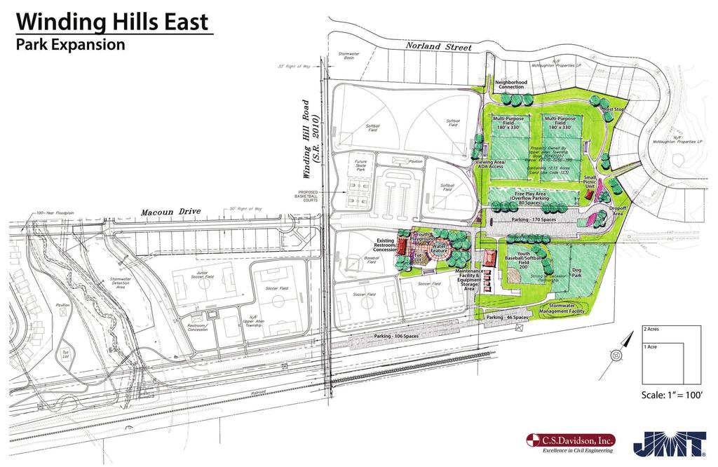
17 5 PARK MASTER SITE PLAN The Park Master Plan was developed in its final form after careful consideration of the site analysis, input from key person interviews and the study committee, review of the conceptual alternatives and pre-final master plan, and consideration of comments provided at the public meeting. Park Design Concept The design concept for Winding Hills East Park seeks to balance the immediate need for active recreational fields while providing opportunities for passive recreation. The concept strives to cluster the active recreation facilities in appropriate areas, provide passive recreation opportunities in appropriate areas, and to connect existing and proposed facilities. The park expansion provides increased opportunities for organized sports activities, self-directed informal recreation, and community special events. Facilities are provided for tots and youth, students, organized leagues, families, and seniors. The design accomplishes the following: Integrates both the existing and new park area into one seamless park. Provides a continuous loop trail system that links to the existing circulation routes while providing multiple trail-related recreation opportunities. Creates a community park with community amenities. Provides facilities for lifetime leisure activities, such as walking, sociability, and picnicking. Places parking areas in convenient locations throughout the park. Respects previous planning and implementation for park facilities. Provides an alternative design for the adjacent 7 acres that allows for development of a youth baseball/softball field and a dog park. Design Considerations The proposed recreation facilities are developed to accommodate a variety of users of varying ages, interests, and abilities. Areas for informal, non-programmed recreation and areas for programmed and structured activities are provided. Proposed facilities are described below. Primary Facilities Access and Parking There are two existing access points to the Winding Hills East Park. The master plan expansion utilizes both entrances by extending the access drives to the two new proposed parking areas. Both parking areas are convenient to the activity areas. The northern parking area contains 85 spaces and has been developed with a convenient drop-off and turnaround area. The adjacent overflow parking area has a capacity of 160 spaces. The alternative design with the additional 7 acres can accommodate 170 spaces, with an additional 80 spaces in the designated overflow parking area. The park access drives should be paved and painted with markings to designate two-way travel. Paved handicap parking spaces with appropriate signage and pavement markings should be provided in each parking area. Parking must be developed in accordance with applicable ordinances and include ADA spaces. Park Master Site Plan 15


18 Winding Hills East Park Expansion Youth Playground / Tot Lot / and Splash Pad An age-segregated playground has been designed to serve as the main gathering area for the park. The playground includes a tot lot for children ages two to five years old, a youth playground for ages six to twelve years old, and a water splash pad for water play. The tot lot, youth playground and splash pad must be developed within areas of safety surfacing and located as recommended for safe play. The area surrounding the play area will be developed with a paved plaza to link to the existing restroom and concession building. Pavement and safety surface configuration, textures, and colors will create and separate the various gathering and play areas. Mounded landscape treatments are proposed adjacent to the access drive to create a buffer and separation for the drive. Benches, picnic tables, seat walls, and landscape treatments will complement and connect the areas and provide a comfortable and relaxing space for park users. Multipurpose Fields Two full size (225 x 360 ) rectangular athletic fields are proposed. The recommended thirty-foot minimum clearance on all sides has been provided and the preferred north-south orientation is accommodated. The fields should be developed with percent slopes for positive surface drainage. A pavilion and parking are located adjacent to the fields and conduits to accommodate future lights for extended play times have been provided. Soil tests should be performed to determine the soil amendment requirements for turf grass development and proper field drainage for the multi-purpose fields and all other athletic fields. The multi-purpose fields could accommodate a variety of sports as noted in the field size table. All field sizes are in accordance with the layout requirements and standards of the National Federation of State High School Associations. Field Size Minimum Sideline Clearances Field Hockey 180 x , 30 on player s side Soccer 180 x on both sides Football 180 x on both sides Lacrosse 180 x on both sides Youth Baseball/Softball Field A youth field with a skinned infield and 200 foot outfield is proposed to accommodate both youth baseball and softball. The field should be developed with a percent slope. The proposed orientation is northeast/southwest to accommodate daytime and evening play. Outfield fencing, spectator seating, and other field amenities, including foul post, should be provided. Open Lawn Area/OverFlow Parking An informal open lawn area to support multiple uses is proposed between the parking areas and the multi-purpose fields. This area is intended to provide a variety of opportunities for informal recreation and free play. The area includes a small picnic pavilion, grills, and horseshoe courts that can When developing playground areas, the following general guidelines should be incorporated into the design: The playground layout, equipment, and safety zone should comply with the Consumer Product Safety Commission (CPSC) Guidelines for Playground Safety Playgrounds must meet the requirements of the Americans with Disabilities Act (ADA), which requires that an accessible route be provided from walkways/parking areas to the playground equipment and that a portion of the equipment offer activities that can be utilized by physically challenged children. Playgrounds should be age-segregated to accommodate children of different ages and abilities. The playgrounds should have signs identifying the age appropriate areas of play. The American Society for Testing and Materials references for public playground safety include:»» F1487 Standard Consumer Safety Performance Specification for Playground Equipment for Public Use.»» F2373 Standard Consumer Safety Performance specification for Public Use Play Equipment for Children 6 Months through 23 Months.»» F1292 Standard Specification for Impact Attenuation of Surface Systems Under and Around Playground Equipment. 16


19 accommodate group rentals and a variety of informal recreation associated with group picnics. Additionally, the open lawn area will serve as overflow parking for tournament play. Trails The existing trails throughout park are of varying widths and do not provide ADA access to all facilities. Proposed trails are interconnected to the existing trails and extend through the park to provide accessible routes to facilities and activity areas and provide opportunities for walking, jogging, and exploring the park. Bituminous pavement is suggested with consideration of accessibility requirements and a consistent 8-foot wide trail recommended. The trail system should be connected to the sidewalk system for the adjacent developments. The minor connections should be developed at a minimum five foot width. Support Facilities Site Furnishings The park should have facilities that enhance the convenience of visiting and create a welcoming environment. Picnic tables should be provided at pavilions and informally in clearings near activity areas. Benches should be provided at gathering places and periodically along trails. Park furnishings that provide for the leisurely enjoyment of the park are suggested. Furnishings should consider the needs of seniors and persons with disabilities, and should include picnic tables that accommodate wheelchairs and benches in shaded locations. Trash receptacles should be located in activity areas. What is a Dog Park? A dog park is a contained public area where dog owners may allow their dogs to run off-leash. Benefits of Dog Parks Dog parks designate an area where dog owners can allow their animals to run off-leash. Dog parks introduce an added attraction to parks and can sometimes be revenue generators. Dog parks are more accommodating for physically disabled persons and senior citizens who cannot always walk with their dogs. Dog parks create unique recreational and social outlets for dogs and owners. Dog parks promote behavioral socialization for dogs and responsible pet ownership for owners. Some dog parks have discouraged delinquent activity in inner city parks. Dog parks have offered an alternative for dog owners who are no longer permitted to walk their dogs on-leash in areas where dogs present ecological hazards to the park environment. - National Recreation and Park Association Planning Parks For Pets Split Rail Fence The use of split rail fencing is already being utilized to define the park boundary and separate public and private spaces. The use of the split rail fence provides a pleasant and inviting image for the park and its use should be carried over to the park expansion areas to unite the various areas of the park. Maintenance/Storage Building A new maintenance and storage building is proposed for the park in an effort to group and centralize storage and maintenance facilities. This area is not removed from the public eye so the building architecture and maintenance areas should reflect the character of the existing buildings. The structure offers ample area for a two bay garage building with office space, maintenance and storage yard, and storage shed areas. Dog Park An area dedicated to off-leash dog use is proposed for development on the additional 7 acres being considered for acquisition by the Township. The dog park offers an enclosed area, approximately one and a half acres in size, for dog owners to take their dogs for off leash exercise and socializing. This dog park will consist of two areas: one area for large dogs and one area for small dogs. Each area is defined with, and separated by, a fivefoot fence with a double gate entrance to secure dogs from inadvertently escaping the designated area. The proposed entrance space is developed with signage displaying rules and regulations for the dog park and equipped with a pet waste disposal system. A small pavilion or shade structure is suggested in the dog park to provide shade and a gathering area for dog caretakers. Park Master Site Plan 17
20 Winding Hills East Park Expansion Landscaping While the park has existed for several years now, the current landscaping is minimal with some newly planted shade trees. As a result, the park seems somewhat barren and provides limited opportunities for shade. Landscaping should be provided to: Provide shade in active areas. Expand food and cover for wildlife. Facilitate connectivity of vegetative cover. Reduce the edge effect of scattered pockets of vegetation, which dilute their ecological function and value. Buffer sensitive natural resources. Improve water quality. Enhance settings for environmental education exhibits and programs. Mitigate and restore eroded areas, areas of invasive species, or other degraded areas. Facilitate circulation patterns and visitor activities in public use areas. Screen adjacent uses. Reduce maintenance costs. The use of native plants should be encouraged in landscaping. Plant material native to the County is adapted to the geographic location and, as a result, will require less maintenance, withstand the extremes in climate change, be less susceptible to disease and pests, and propagate naturally. Native plant material will also provide needed habitat and food for small mammals and birds. The introduction of native plants and enhancement of the natural landscape will help reduce the opportunity for exotic species to establish a foothold on the site. Utilities The proposed maintenance/storage building will require sewer, water and electrical service. Facilities have been located with considerations for existing and future utility availability. The master plan recommends providing security lighting at all pavilions. Stormwater Management The proposed stormwater improvements include pervious pavement bituminous parking areas with below grade detention along with at surface detention facilities. Shallow depressions with earthen berms will be incorporated throughout the park expansion site to control the rate of stormwater runoff and to promote groundwater recharge over a large surface area. Stormwater will ultimately be conveyed to an existing point of concentration located in the northeastern portion of the project site. Any post development runoff will be discharged in a drainage area common to adjacent facilities constructed to manage stormwater runoff for the Orchard Glen land development. Site Amenities The park should be developed with site amenities that enhance the experience for users in order to create a welcoming environment. Provide mix of additional picnic tables and benches to continue to provide a consistent design theme at gathering places and periodically along new trail segments. Benches with backs and backless benches should be placed appropriately. 18
21 Drinking fountains are already provided at the existing concession/ restroom buildings. Trash receptacles should be provided near the pavilions, along the trails, and at the vehicular drop-off area. Bike racks should be provided near the parking areas and at the pavilion and concession/ restroom buildings. Signage System The park should be renamed, Winding Hills Park, to identify one park instead of two separate ones. Signs identifying the park at each entrance are proposed. The actual location of the entrance signs and related plantings should be field verified to provide adequate visibility. Informational kiosks should be provided and located at each of the restroom/concession buildings. Kiosks typically post information regarding park policies, facility use schedules, and a calendar of community events. A signage system should be developed with a hierarchy of signs designed to convey the image of a quality recreation facility and communicate necessary information. Maintenance and Operations Plan Maintenance is the largest single recurring expenditure in the development of a park. As a result, the Township must consider developing a formalized plan that will outline strategies for maintaining the park as improvements are implemented. The Maintenance and Operations Plan will address the following: Risk Management Security Plan Maintenance Standards Operating Budget Organization and Staffing requirements Revenue generation Park Security The park has seen some small acts of mischief and vandalism over the years. No graffiti or damage to equipment or injury to park users have been reported. As the park expands and daily use grows it is imperative that the Township begin to plan for operations and management of the park, which will address park safety and security. While the long term goal is to develop a Maintenance and Operation Plan that formally addresses security, the follow short-term objectives should be implemented as expansion efforts move forward: Coordinate with the Police Department to develop a patrolling system for park and visitor protection. Establish a formalized record keeping system to document maintenance tasks and report the repair of park problems. Park Master Site Plan 19
22 Winding Hills East Park Expansion A Sign System for Community Parks Park Entrance Signs Sign Purpose Sign Location Park Entrance Signs Identify the park s entrances and owner. Entrances to parking areas. Information Kiosks Provide information about the park such as park policies, park and trail maps, special events calendar, etc. At restroom/concession/storage building Mile Markers Identify location on a trail (mile indication visible from both sides of the marker). At one-quarter mile intervals along the trails. Interpretive Signs Provide environmental education and general interest information. At points of interest in the park and along the trails. Sign Guidelines Vandal Resistant Utilize materials such as phenolic resin panels (no frame required) or fiberglass embedded panels (frame required) which resist abrasions, graffiti, solvents, etc. Weather Resistant Utilize materials that will not fade or otherwise degrade from sunlight, moisture, or the freeze/thaw cycle. Meet PennDOT, Regulations Along PennDOT roadways use standard signs. Promote Consistent Image Develop a family of graphics (logo, font, colors, etc.) that will be used on signs throughout the park to unify the site. Graphics Utilize maps, graphic illustrations and photographs, and text to communicate the intended message. Maps Include maps at key locations throughout the park (main activity areas, trailheads, etc.) to orient the visitor. 20
23
24


25 6 PHASING AND IMPLEMENTATION Development Phases The expansion of Winding Hills East Park is anticipated to occur in several phases. Like most parks, development is phased based on community need, funding opportunities, logical sequences of construction, and considerations for how the park will function. As funding is available, as needs change in the community, or as opportunities present themselves, the sequence of development may change. During the plan s implementation, it is important for the Township to remain flexible and adapt to these changes as they move forward with implementation of the Master Plan. Cost Summary Costs for the proposed improvements were compiled for two individual phases (Module A and Module B) based on comments provided by the general public, the project steering committee, and the park and recreation board. Module A $527,800 Module B $586,500 Module A A detailed opinion of probable development costs for each of the modules has been included on the following pages. During both the public meeting and the project steering committee meetings, it was conveyed that the most favorable and desirable aspects of the master plan was the central hub area that included the playground, tot lot, splash pad, and outdoor plaza space. The addition of playground equipment, water features, seating areas, landscaping, passive recreation opportunities, etc. would better diversify the activities conducted at the park. The Recreation Board was also in favor of the central hub concept; however, they felt the greatest priority was to establish additional playing surfaces. As a result, Modules A and B were developed as initial phases to be considered depending on available budgets and grant and funding opportunities. Module B The overall park projected cost will depend on the development of the 12 verses the 19 acre scenarios which were estimated between $2-3 million. Costs are based on prevailing wages for year 2015 construction prices. A 10% contingency and a 15% professional design fee has been included in each estimate. An inflation factor has not been included in the phased costs. Phasing and Implementation 23
26 Winding Hills East Park Expansion Winding Hill East Park - Expansion Budget Estimate - Module A Phase 1 Youth Playground / Tot Lot April 1, 2015 ITEM DESCRIPTION EST. UNITS UNIT TOTAL QTY. PRICE COST A. Site Improvements A.1 General Requirements $18,164 A.1.1 Mobilization 1 LS $3,842 $3,842 A.1.2 Survey/Construction Layout 2 DAY $1,000 $2,000 A.1.3 Submittals/Shop Drawings 2 MONTH $400 $800 A.1.4 Bonding 1 LS $11,522 $11,522 A.2 Site Preparation and Demolition $5,200 A.2.1 Strip and Stockpile Topsoil (4" deep) 500 CY $4 $2,000 A.2.2 Temporary Construction Fencing 800 LF $4 $3,200 A.3 Erosion and Sedimentation $9,000 A " Compost Filter Sock 400 LF $5 $2,000 A.3.2 Rock Construction Entrance 1 EA $2,000 $2,000 A.3.3 SECS allowance 1 LS $5,000 $5,000 A.4 Earthwork $5,250 A.4.1 Bulk Excavation and Fill A Bulk Cut (Common Earth) 750 CY $3 $2,250 A Bulk Fill (Common Earth) 750 CY $4 $3,000 Balance: CY A.6 Storm Drainage - Allowance 1 LS $5,000 $5,000 A.7 Landscaping $21,300 A.8.1 Spread Topsoil 6" Thick, Fine Grade, Fertilize 500 SY $2.20 $1,100 A.8.2 General Lawn Seeding 5,000 SF $0.15 $750 A.8.3 Deciduous Trees 6 EA $500 $3,000 A.8.4 Small Trees 2 EA $275 $550 A.8.5 Shrubs 10 EA $60 $600 A.8.6 Grasses/Potted Plants 10 EA $30 $300 A.8.7 Perennials 1 LS $15,000 $15,000 A.9 Youth Playground $145,428 A.12.1 Play Equipment 1 LS $65,000 $65,000 A.12.2 Play Equipment Installation 1 LS $26,000 $26,000 A.12.3 Excavation Fine Grade and Compaction 160 CY $37 $5,920 A.12.4 Resilient Surfacing 3200 SF $11 $35,200 A.12.5 Underdrain 150 LF $31 $4,575 A.12.6 Concrete Curb Edging 250 LF $20 $5,000 A.12.7 Stone Base and Filter Fabric 360 SY $10 $3,733 A.10 Tot Lot $132,528 Page 1 of 2 24
27 A.13.1 Play Equipment 1 LS $55,000 $55,000 A.13.2 Play Equipment Installation 1 LS $22,000 $22,000 A.13.3 Excavation Fine Grade and Compaction 160 CY $37 $5,920 A.13.4 Resilient Surfacing 3300 SF $11 $36,300 A.13.5 Underdrain 150 LF $31 $4,575 A.13.6 Concrete Curb Edging 250 LF $20 $5,000 A.13.7 Stone Base and Filter Fabric 360 SY $10 $3,733 A.11 Porous Pavers $42,000 A.15.1 Colored Concrete 3,500 SF $12 $42,000 SUBTOTAL: $383,870 10% DESIGN CONTINGENCY: $38,387 TOTAL BASE COST : $422,257 1 Professional Design Fees $63,339 2 Construction Contingency Fund (10%) $42,226 TOTAL PROJECT ESTIMATE $527,822 Note: Probable cost for site work does not include the following: 1. Maintenance Building and Storage Sheds. 2. Rerouting gas, CATV, or phone lines. Additional improvements as may be required by municipal or other reviewing agencies having jurisdiction 3. Utility service and or connection fees. 4. Utility service extension to the park 5. Removal of unsuitable materials, sink hole remediation, or archeological investigations or phase services. 6. Project financing costs 7. Site renovations or repairs beyond the boundary of the park. 8. Soil amendments and or remediation JMT, Inc. is not a construction contractor and therefore probable construction cost opinions are based solely upon our experience with construction. This requires JMT to make a number of assumptions as to actual conditions which will be encountered on the site; the specific decisions of other design professionals engaged; the means and methods of construction the contractor will employ; contractors' techniques in determining prices and market conditions at the time, and other factors over which JMT has no control. Given these assumptions which must be made, JMT states that the above probable construction cost opinion is a fair and reasonable estimate for construction costs. Page 2 of 2 Phasing and Implementation 25

28 Winding Hills East Park Expansion Winding Hill East Park - Expansion Budget Estimate - Module B Phase 1 Athletic Field / Parking 12 Acre Parcel April 1, 2015 ITEM DESCRIPTION EST. UNITS UNIT TOTAL QTY. PRICE COST A. Site Improvements A.1 General Requirements $22,561 A.1.1 Mobilization 1 LS $4,290 $4,290 A.1.2 Survey/Construction Layout 2 DAY $1,000 $2,000 A.1.3 Submittals/Shop Drawings 2 MONTH $400 $800 A.1.4 Entrance Sign/Funding Acknowledgment 1 EA $2,500 $2,500 A.1.5 Bonding 1 LS $12,971 $12,971 A.2 Site Preparation and Demolition $38,120 A.2.1 Strip and Stockpile Topsoil (4" deep) 6,655 CY $4 $26,620 A.2.2 Load and Haul Debris from Site 1 LS $1,500 $1,500 A.2.3 Temporary Construction Fencing 2,500 LF $4 $10,000 A.3 Erosion and Sedimentation $23,000 A " Compost Filter Sock 200 LF $5 $1,000 A.3.2 Rock Construction Entrance 1 EA $2,000 $2,000 A.3.3 SECS allowance 1 LS $20,000 $20,000 A.4 Earthwork $68,495 A.4.1 Bulk Excavation and Fill A Bulk Cut (Common Earth) 9,785 CY $3 $29,355 A Bulk Fill (Common Earth) 9,785 CY $4 $39,140 Balance: CY A.5 Multi-Purpose Field $29,300 A.5.1 Spread Topsoil, Fine Grade, Fertilize 2,650 CY $2 $5,300 A.5.2 Athletic Field Seeding 24,000 SY $1 $24,000 A.6 Flexible Paving $149,500 A.6.1 Porous Bituminous Paving and Base - 85 sp parking area 3,260 SY $25 $81,500 A.6.2 Access Drive and Turn Around 2,000 SY $25 $50,000 A Foot Wide Trail 1,000 SY $18 $18,000 A.7 Storm Drainage - Allowance 1 LS $60,000 $60,000 A.8 Landscaping $35,600 A.8.1 Spread Topsoil 6" Thick, Fine Grade, Fertilize 8,000 SY $2.20 $17,600 A.8.2 General Lawn Seeding SF $0.15 $18,000 SUBTOTAL: $426,576 10% DESIGN CONTINGENCY: $42,658 TOTAL BASE COST : $469,234 Page 1 of 2 26
29 1 Professional Design Fees $70,385 2 Construction Contingency Fund (10%) $46,923 TOTAL PROJECT ESTIMATE $586,542 Note: Probable cost for site work does not include the following: 1. Maintenance Building and Storage Sheds. 2. Rerouting gas, CATV, or phone lines. Additional improvements as may be required by municipal or other reviewing agencies having jurisdiction 3. Utility service and or connection fees. 4. Utility service extension to the park 5. Removal of unsuitable materials, sink hole remediation, or archeological investigations or phase services. 6. Project financing costs 7. Site renovations or repairs beyond the boundary of the park. 8. Soil amendments and or remediation JMT, Inc. is not a construction contractor and therefore probable construction cost opinions are based solely upon our experience with construction. This requires JMT to make a number of assumptions as to actual conditions which will be encountered on the site; the specific decisions of other design professionals engaged; the means and methods of construction the contractor will employ; contractors' techniques in determining prices and market conditions at the time, and other factors over which JMT has no control. Given these assumptions which must be made, JMT states that the above probable construction cost opinion is a fair and reasonable estimate for construction costs. Page 2 of 2 Phasing and Implementation 27
30 Winding Hills East Park Expansion This page intentionally left blank. 28
31 A APPENDIX A A sustainable park produces the following benefits to a community: economic benefits by attracting users to the park and the surrounding areas where the park resides; environmental benefits by reducing impacts to the environment and providing a safe area for wildlife; and health and safety benefits by giving the community a educational environment, allowing for active recreation, and reducing crime, creating stronger/safer neighborhoods surrounding the park. Sustainability and green design considerations have become increasingly important in today s modern age, and applying these values to park design has become a standard practice. As defined by Creating Sustainable Community Parks: A Guide to Improving Quality of Life by Protection of Natural Resources, a sustainable community park is one where natural resources are protected, wildlife habitats are improved and human recreational uses and maintenance practices do not conflict with the surrounding environment, but rather enhances it. The recently published Draft Guidelines and Performance Benchmarks for Sustainable Sites Initiative, further defines sustainability as land practices that meet the needs of the present without compromising the ability of future generations to meet their own needs. The green initiative allows for the park to become self sufficient, and maintain self sufficiency; while reducing the amount of time and cost that must be required to maintain certain areas in both the long- and shortterms. Guiding Principles of a Sustainable Site Do No Harm Make no changes to the site that will degrade the surrounding environment. Promote projects on sites where previous disturbance/development presents an opportunity to regenerate ecosystem services through sustainable design. Precautionary Principle Be cautious in making decisions that could create risk to human and environmental health. Some actions can cause irreversible damage. Examine a full range of alternatives including no action and be open to contributions from all affected parties. Design with Nature and Culture Create and implement designs that are responsive to economic, environmental, and cultural conditions with respect to the local, regional, and global context. Use a decision-making hierarchy of preservation, conservation, and regeneration. Maximize and mimic the benefits of ecosystem services by preserving existing environmental features, conserving resources in a sustainable manner, and regenerating lost or damaged ecosystem services. Provide Regenerative Systems as Intergenerational Equity Provide future generations with a sustainable environment supported by regenerative systems and endowed with regenerative resources. Support a Living Process Continuously re-evaluate assumptions and values, and adapt to demographic and environmental change. Use a Systems Thinking Approach Understand and value the relationships in an ecosystem, and use an approach that reflects and sustains ecosystem services; re-establish the integral and essential relationship between natural processes and human activity. Applying Sustainability and Green Design to Park Development 29
32 Winding Hills East Park Expansion Use a Collaborative and Ethical Approach Encourage direct and open communication among colleagues, clients, manufacturers and users to link long-term sustainability with ethical responsibility. Maintain Integrity in Leadership and Research Implement transparent and participatory leadership, develop research with technical rigor and communicate new findings in a clear, consistent, and timely manner. Foster environmental stewardship In all aspects of land development and management, foster an ethic of environmental stewardship an understanding that responsible management of healthy ecosystems improves the quality of life for present and future generations. Taken from The Sustainable Sites Initiative, Guidelines and Performance Benchmarks, American Society of Landscape Architects ADA in Outdoor Setting The Recommendations for Accessibility Guidelines: Outdoor Developed Areas require compliance with the ADA but permit departures from the specific technical provisions where at least one of the following conditions exists: Where compliance would cause substantial harm to cultural, historic, religious, or significant natural features or characteristics; or, Where compliance would substantially alter the nature of the setting or the purpose of the facility, or portion of the facility; or, Where compliance would require construction methods or materials that are prohibited by Federal, state, or local regulations or statutes; or, Where compliance would not be feasible due to terrain or the prevailing construction practices. 30
33 Green Design The redevelopment of the park provides an opportunity to incorporate green design techniques. Integration of green design principles and techniques for future construction/improvements is encouraged to minimize the impact of park development on the natural resources. Green Design Considerations Consideration Intent Application Erosion and sedimentation control Reduce negative impact on air and water quality Provide erosion control measures and best management practices (BMPs) during new construction activities. Eliminate impact to steep slope areas. Reduce Site Disturbance Develop Sustainable Trails Limit development to appropriate sites to reduce the impact on the landscape and habitat. Limit erosion attributed to inappropriate trail placement. Construct improvements within existing clearings or developed areas. Develop trails that follow the contour of the land. Use switchbacks to navigate steep terrain, where necessary. Eliminate highly erodible trails. Stormwater management Limit disruption and pollution of natural water courses, reduce increased runoff and promote infiltration. Minimize crossings at water courses. Where crossings are necessary, provide measures for efficient passage of water. Utilize porous pavement to promote infiltration of stormwater runoff. Size parking areas to meet park need and provide turf overflow parking for high use occurrences and special events. Reduce heat islands Minimize impact of microclimate. Provide plantings in the large, expansive parking areas to break up the hard surface and promote infiltration. Dawn to dusk policy where appropriate. Reduce light pollution Improve night sky visibility and reduce impact on nocturnal environments. Limit lighting within the park. Where night lighting is necessary for safety and security, provide shields or specify full cut-off fixtures and only specify the necessary lumens. Innovative wastewater treatment Reduce the generation of wastewater and potable water demand Provide self mulching or other environmentally friendly treatment alternatives. Recycled building materials Limit the use of consumptive building materials Utilize recycled plastic and building materials in new construction. Applying Sustainability and Green Design to Park Development 31
34 Winding Hills East Park Expansion Green Design Considerations - continued Consideration Intent Application Local materials and suppliers Support the local economy and reduce the environmental impact resulting from transportation Purchase products locally produced. Maximize solar orientation Reduce electric needs through proper building orientation. Orient buildings to take advantage of natural light and heat. Energy consumption Minimize use of fossil fuels. Install a ground source geothermal heat pump system for heating and cooling of buildings. Plant deciduous trees to cool buildings in the summer and allow solar access in winter. Layout and orient buildings and outdoor use areas to take advantage of cooling summer breezes. Connect park sites to regional trail systems so that nonmotorized transportation modes can be used to access the site. Install solar powered amenities/features. Promote water conservation Reduce water use to lower burden on supply. Select native and drought tolerant plants to reduce watering and maintenance demands. Mulch landscape areas to retain moisture and minimize the need to water plants. Use water efficiently Maximize water collection to reduce burden on supply. Collect rainwater and runoff in rain barrels for watering landscaping and maintenance needs. Direct rainwater to rain gardens to promote groundwater recharge. Use high efficiency fixtures and composting toilets to reduce demand. Use re-circulating and water treatment systems for splash pads and spray features. Emphasize and promote recycling Reduce the amount of new materials required and lower the demand for new materials to be produced. Reuse existing buildings, materials and infrastructure. Build with salvaged materials whenever available. Participate in LEED system. Employ the Leadership in Energy and Environmental Design (LEED) Green Building Rating System on site as the national standard for Green Design. Use the LEED project checklist for all aspects of design from erosion & sedimentation control to green power and materials. 32
35 Best Management Practices Development of the park as conceived in this master plan will involve earthwork and construction activities. Best Management Practices (BMPs) are encouraged throughout the construction process to protect the resources and stabilize them through creative design. Best Management Practices will promote a stable future for the site. Detailed Examples of Best Management Practices can be found in Pennsylvania Stormwater Best Management Practices Manual. Some basic examples are listed below for informational purposes and should be considered where applicable in the redevelopment of the park. Incorporation of these facilities will require site specific soils testing to determine infiltration rates and plan for incorporation of applicable BMPs. Best Management Practices BMP Purpose Application Constructed treatment wetlands Critical area planting Remove a wide variety of pollutants such as suspended solids, nutrients, and organic pollutants. Stabilize slope, improve wildlife habitat, slow stormwater run-off. Shallow water-filled basins planted with emergent plant vegetation. Place at stream/drainage-way outfall to water bodies. Areas of erodible soils and/or steep slope and at the edge of the stream and perimeter of pond. Filter strip To trap sediment and convey run-off from paved surfaces to stormwater channels and reduce run-off velocity Adjacent to impervious surfaces and on gentle slopes with sheet flow. Adjacent to springs, streams and ponds to filter sediment. Grass swales Level spreader Stream bank stabilization Minimize site clearing Reduce impervious infrastructure Best management plan for construction activities Run-off conveyance, pollution, and sediment filtering device and increased ground water infiltration. To reduce the erosion effects of concentrated run-off and promote infiltration. Protect critical sections of a stream bank where standard vegetative practices are not feasible or offer insufficient protection. Minimize disruption to the site s natural systems and preserve the natural stabilizing and filtering vegetation of the site. Reduce stormwater run-off and promote infiltration. To prevent soil erosion, sediment, and other pollutants from entering springs, streams, ponds, etc. Where natural drainage ways can be incorporated into the stormwater design in lieu of piped conveyance. Adjacent to paved surfaces and at pipe and channel discharge points. Banks of springs, streams or swales that need to be stabilized due to unstable soil and steep banks. Where development is proposed. Where development is proposed. Reduce driveway width, parking area dimensions, and paved areas to minimum dimensions. Utilize coarse aggregate porous surface in lieu of impervious pavement. Utilize stabilized turf for overflow parking. Where development is proposed. Utilize during construction and post- construction period. Applying Sustainability and Green Design to Park Development 33
36 Winding Hills East Park Expansion This page intentionally left blank. 34
37 B Appendix B Introduction The Pennsylvania Natural Diversity Inventory Environmental Review Tool (PNDI ER Tool) enables the public to perform online PNDI searches for potential impacts to threatened, endangered, special concern species and special concern resources in PA. Anyone including property owners, consultants, project planners, PA DEP, or PA CCD staff can access the tool for PNDI project screening. The PNDI ER Tool is used prior to submitting permit applications to DEP or during any project s pre-planning phases. The user performs the search online using the ER Tool, prints the results from the search (called PNDI Environmental Review Receipt ), and follows the instructions on the receipt. For more information about the receipt results and what they mean, please visit the PNDI Receipt page. In order to adequately provide for the protection of special concern species and resources while also reducing the number of false hits when conducting PNDI searches, it is important that the correct project area and type is entered into the PNDI ER Tool. If you believe you have entered the information incorrectly, please rerun the search. Large Projects Some projects are too large to be drawn in the PNDI Environmental Review Tool and are therefore called Large Projects. To find out if your project is a Large Project, please visit the Large Project Information Page. Resource Agency Jurisdiction A PNDI ER Tool web-site inquiry generates online search results concerning the potential impacts of a project to special concern species and resources. Four government agencies have jurisdiction over the protection of these resources: U.S. Fish and Wildlife Service Federally listed, proposed and candidate species Statute: Endangered Species Act of U.S.C et seq. Pennsylvania Game Commission PA state-listed birds and mammals Statute: Game and Wildlife Code 34 Pa. C.S.A. 101 et seq. Pennsylvania Fish and Boat Commission PA state-listed fish, reptiles, amphibians, and aquatic organisms Statute: Fish and Boat Code 30 Pa. C.S.A. 101 et seq. Pennsylvania Department of Conservation and Natural Resources PA state-listed plants, natural communities, terrestrial invertebrates and geological features Statute: Wild Resources Conservation Act 32 P.S et seq. Pennsylvania Natural Diversity Inventory (PNDI) Report 35
38 Winding Hills East Park Expansion Early Coordination Because the Environmental Review Tool is easily accessible to the public, it is recommended that PNDI coordination be completed prior to project development and submission of any permit applications. During instances when the PNDI search indicates potential impacts, early consultation with the proper special concern species or resource jurisdictional agencies (preferably prior to plan development) is crucial. Early consultation not only minimizes associated delays and cost, but also facilitates the integration of more effective conservation measures into project planning. Source: 36

39 PNDI Project Environmental Review Receipt Project Search ID: PROJECT INFORMATION Project Name: Winding Hills East Park Date of review: 6/19/2015 9:22:45 AM Project Category: Recreation,Other Project Area: 26.3 acres County: Cumberland Township/Municipality: Upper Allen Quadrangle Name: LEMOYNE ~ ZIP Code: Decimal Degrees: N, W Degrees Minutes Seconds: 40 11' 31" N, ' 16.5" W 2. SEARCH RESULTS Agency Results Response PA Game Commission No Known Impact No Further Review Required PA Department of Conservation No Known Impact No Further Review Required and Natural Resources PA Fish and Boat Commission Potential Impact FURTHER REVIEW IS REQUIRED, See Agency Response U.S. Fish and Wildlife Service No Known Impact No Further Review Required As summarized above, Pennsylvania Natural Diversity Inventory (PNDI) records indicate there may be potential impacts to threatened and endangered and/or special concern species and resources within the project area. If the response above indicates "No Further Review Required" no additional communication with the respective agency is required. If the response is "Further Review Required" or "See Agency Response," refer to the appropriate agency comments below. Please see the DEP Information Section of this receipt if a PA Department of Environmental Protection Permit is required. Page 1 of 4 Pennsylvania Natural Diversity Inventory (PNDI) Report 37
40 Winding Hills East Park Expansion PNDI Project Environmental Review Receipt Project Search ID: Note that regardless of PNDI search results, projects requiring a Chapter 105 DEP individual permit or GP 5, 6, 7, 8, 9 or 11 in certain counties (Adams, Berks, Bucks, Carbon, Chester, Cumberland, Delaware, Lancaster, Lebanon, Lehigh, Monroe, Montgomery, Northampton, Schuylkill and York) must comply with the bog turtle habitat screening requirements of the PASPGP. 3. AGENCY COMMENTS Regardless of whether a DEP permit is necessary for this proposed project, any potential impacts to threatened and endangered species and/or special concern species and resources must be resolved with the appropriate jurisdictional agency. In some cases, a permit or authorization from the jurisdictional agency may be needed if adverse impacts to these species and habitats cannot be avoided. These agency determinations and responses are valid for two years (from the date of the review), and are based on the project information that was provided, including the exact project location; the project type, description, and features; and any responses to questions that were generated during this search. If any of the following change: 1) project location, 2) project size or configuration, 3) project type, or 4) responses to the questions that were asked during the online review, the results of this review are not valid, and the review must be searched again via the PNDI Environmental Review Tool and resubmitted to the jurisdictional agencies. The PNDI tool is a primary screening tool, and a desktop review may reveal more or fewer impacts than what is listed on this PNDI receipt. The jursidictional agencies strongly advise against conducting surveys for the species listed on the receipt prior to consultation with the agencies. PA Game Commission RESPONSE: No Impact is anticipated to threatened and endangered species and/or special concern species and resources. PA Department of Conservation and Natural Resources RESPONSE: No Impact is anticipated to threatened and endangered species and/or special concern species and resources. PA Fish and Boat Commission RESPONSE: Further review of this project is necessary to resolve the potential impacts(s). Please send project information to this agency for review (see WHAT TO SEND). PFBC Species: (Note: The PNDI tool is a primary screening tool, and a desktop review may reveal more or fewer species than what is listed below.) Scientific Name: Sensitive Species** Common Name: Current Status: Threatened U.S. Fish and Wildlife Service RESPONSE: No impacts to federally listed or proposed species are anticipated. Therefore, no further consultation/coordination under the Endangered Species Act (87 Stat. 884, as amended; 16 U.S.C et seq. is required. Because no take of federally listed species is anticipated, none is authorized. This response does not reflect potential Fish and Wildlife Service concerns under the Fish and Wildlife Coordination Act or other 38 Page 2 of 4
41 PNDI Project Environmental Review Receipt Project Search ID: authorities. * Special Concern Species or Resource - Plant or animal species classified as rare, tentatively undetermined or candidate as well as other taxa of conservation concern, significant natural communities, special concern populations (plants or animals) and unique geologic features. ** Sensitive Species - Species identified by the jurisdictinal agency as collectible, having economic value, or being susceptible to decline as a result of visitation. WHAT TO SEND TO JURISDICTIONAL AGENCIES If project information was requested by one or more of the agencies above, send the following information to the agency(s) seeking this information (see AGENCY CONTACT INFORMATION). Check-list of Minimum Materials to be submitted: SIGNED copy of this Project Environmental Review Receipt Project narrative with a description of the overall project, the work to be performed, current physical characteristics of the site and acreage to be impacted. Project location information (name of USGS Quadrangle, Township/Municipality, and County) USGS 7.5-minute Quadrangle with project boundary clearly indicated, and quad name on the map The inclusion of the following information may expedite the review process. A basic site plan(particularly showing the relationship of the project to the physical features such as wetlands, streams, ponds, rock outcrops, etc.) Color photos keyed to the basic site plan (i.e. showing on the site plan where and in what direction each photo was taken and the date of the photos) Information about the presence and location of wetlands in the project area, and how this was determined (e.g., by a qualified wetlands biologist), if wetlands are present in the project area, provide project plans showing the location of all project features, as well as wetlands and streams 4. DEP INFORMATION The Pa Department of Environmental Protection (DEP) requires that a signed copy of this receipt, along with any required documentation from jurisdictional agencies concerning resolution of potential impacts, be submitted with applications for permits requiring PNDI review. For cases where a "Potential Impact" to threatened and endangered species has been identified before the application has been submitted to DEP, the application should not be submitted until the impact has been resolved. For cases where "Potential Impact" to special concern species and resources has been identified before the application has been submitted, the application should be submitted to DEP along with the PNDI receipt. The PNDI Receipt should also be submitted to the appropriate agency according to directions on the PNDI Receipt. DEP and the jurisdictional agency will work together to resolve the potential impact(s). See the DEP PNDI policy at Page 3 of 4 Pennsylvania Natural Diversity Inventory (PNDI) Report 39
42 Winding Hills East Park Expansion PNDI Project Environmental Review Receipt Project Search ID: ADDITIONAL INFORMATION The PNDI environmental review website is a preliminary screening tool. There are often delays in updating species status classifications. Because the proposed status represents the best available information regarding the conservation status of the species, state jurisdictional agency staff give the proposed statuses at least the same consideration as the current legal status. If surveys or further information reveal that a threatened and endangered and/or special concern species and resources exist in your project area, contact the appropriate jurisdictional agency/agencies immediately to identify and resolve any impacts. For a list of species known to occur in the county where your project is located, please see the species lists by county found on the PA Natural Heritage Program (PNHP) home page ( Also note that the PNDI Environmental Review Tool only contains information about species occurrences that have actually been reported to the PNHP. 6. AGENCY CONTACT INFORMATION PA Department of Conservation and Natural Resources Bureau of Forestry, Ecological Services Section 400 Market Street, PO Box 8552, Harrisburg, PA Fax:(717) PA Fish and Boat Commission Division of Environmental Services 450 Robinson Lane, Bellefonte, PA NO Faxes Please 7. PROJECT CONTACT INFORMATION U.S. Fish and Wildlife Service Pennsylvania Field Office 110 Radnor Rd; Suite 101, State College, PA NO Faxes Please. PA Game Commission Bureau of Wildlife Habitat Management Division of Environmental Planning and Habitat Protection 2001 Elmerton Avenue, Harrisburg, PA Fax:(717) Name: Company/Business Name: Address: City, State, Zip: Phone:( ) Fax:( ) 8. CERTIFICATION I certify that ALL of the project information contained in this receipt (including project location, project size/configuration, project type, answers to questions) is true, accurate and complete. In addition, if the project type, location, size or configuration changes, or if the answers to any questions that were asked during this online review change, I agree to re-do the online environmental review. applicant/project proponent signature date 40 Page 4 of 4
 Rare, Candidate, Threatened and Endangered Species PNDI Search No. 20150619519075 Winding Hills East Park Project.")
43 Division of Environmental Services Natural Diversity Section 450 Robinson Lane Bellefonte, PA IN REPLY REFER TO SIR# July 17, 2015 C.S. Davidson, Inc. Jason Reichard 50 W. Middle Street Gettysburg, Pennsylvania RE: Species Impact Review (SIR) Rare, Candidate, Threatened and Endangered Species PNDI Search No Winding Hills East Park Project. CUMBERLAND County: Upper Allen Township Dear Jason Reichard: This responds to your inquiry about a Pennsylvania Natural Diversity Inventory (PNDI) Internet Database search potential conflict or a threatened and endangered species impact review. These projects are screened for potential conflicts with rare, candidate, threatened or endangered species under Pennsylvania Fish & Boat Commission jurisdiction (fish, reptiles, amphibians, aquatic invertebrates only) using the Pennsylvania Natural Diversity Inventory (PNDI) database and our own files. These species of special concern are listed under the Endangered Species Act of 1973, the Wild Resource Conservation Act, and the Pennsylvania Fish & Boat Code (Chapter 75), or the Wildlife Code. An element occurrence of a rare, candidate, threatened, or endangered species under our jurisdiction is known from the vicinity of the proposed project. However, given the nature of the proposed project, the immediate location, or the current status of the nearby element occurrence(s), no adverse impacts are expected to the species of special concern. This response represents the most up-to-date summary of the PNDI data and our files and is valid for two (2) years from the date of this letter. An absence of recorded species information does not necessarily imply species absence. Our data files and the PNDI system are continuously being updated with species occurrence information. Should project plans change or additional information on listed or proposed species become available, this determination may be reconsidered, and consultation shall be reinitiated. Pennsylvania Natural Diversity Inventory (PNDI) Report 41
44 Winding Hills East Park Expansion SIR # Page 2 July 17, 2015 If you have any questions regarding this review, please contact Kathy Gipe at and refer to the SIR # Thank you for your cooperation and attention to this important matter of species conservation and habitat protection. Sincerely, CAU/KDG/dn Christopher A. Urban, Chief Natural Diversity Section 42
45 C surveyed APPENDIX C Topographic Survey Winding Hills East Park Expansion of approximately Acres was by C.S.Davidson, Inc. on January 8, Topographic Survey 43
46 Winding Hills East Park Expansion This page intentionally left blank. 44
47 38 NORTH DUKE STREET, YORK, PA PHONE (717) FAX (717) WEST MIDDLE STREET, GETTYSBURG, PA PHONE (717) FAX (717) W. JAMES STREET, SUITE 102, LANCASTER, PA PHONE (717) FAX (717) UPPER ALLEN TOWNSHIP WINDING HILLS EAST PARK (PROPOSED SITE PLAN) K:\ \dwg\Civil\ _B.dwg, 1/9/ :54:08 AM UPPER ALLEN TOWNSHIP CUMBERLAND COUNTY PENNSYLVANIA MASTER RECREATION PLAN, NO. DATE DESCRIPTION GRAPHIC SCALE ( IN FEET ) 1 INCH = 60 FT. DRAWN BY LWK/ CHECKED BY SCALE 1" = 60' DATE 1/8/2015 DWG. NO _B FILE NO SHEET NO. 2 OF 2
48

49 WINDING HILLS PARK Upper Allen Township Master Site Plan Prepared By: and
1. Parks & Recreation Neighborhood Parks Community Parks Special Use Sites 2. Open Space 3. Trails
 Appendix A: Park Classifications The intent of parks and recreation classifications is to aid in making acquisition and design decisions for park sites, facilities and the organization of recreation space
City of Bonney Lake Allan Yorke Park. MASTER PLAN SUMMARY REPORT June 30, 2016
 City of Bonney Lake Allan Yorke Park MASTER PLAN SUMMARY REPORT June 30, 2016 TABLE OF CONTENTS INTRODUCTION PUBLIC INVOLVEMENT PROCESS MASTER PLAN North Park Central Park South Park East Park Field Development
Charles P. Johnson and Associates. Annapolis Landscape Architects
 Charles P. Johnson and Associates Annapolis Landscape Architects AGENDA Introduction Project Limits and Scope Site Analysis Opportunities & Constraints Program Goals Image Boards Design Alternatives Pros
2. Analysis. DRAFT Gerald Richards & Pleasantview Park Master Plan
 DRAFT Gerald Richards & Pleasantview Park Master Plan 19 Historic Features According to the National Register of Historic Places and the National Historic Landmarks Program, there is nothing of national
City Council March 27, Parks, Recreation, and Trails Master Plan
 City Council March 27, 2018 Parks, Recreation, and Trails Master Plan Planning Process Develop Goals and Objectives Inventory of Areas and Facilities Needs Assessment And Identification Public Participation
Neighborhood Districts
 NEIGHBORHOOD DISTRICTS SEVEN MAIN DISTRICTS Neighborhood Districts While the Development Plan provides a broad-scale overview of the neighborhood, this section focuses on uses and relationships at the
A cknovvledgements. Table of Contents. Project Introduction...1
 Pashek Asscx::iates MARCH2007 A cknovvledgements Pashek Associates would like to thank Jackson Township and the Jackson Township Recreation Board for their valuable contributions, support, and input during
CHAPPLES PARK MASTER PLAN
 CHAPPLES PARK MASTER PLAN Presentation of Preliminary Development Options Public Open House #2 Wednesday November 2 nd, 2016 TONIGHT S AGENDA 1. Welcome & Introductions 2. Presentation by Sierra Planning
Parks, and Recreation & Cultural Arts Master Plan Update
 Parks, and Recreation & Cultural Arts Master Plan Update Community Profile Public Input Summary: Staff Interviews conducted April 14 and 15, 2014 Citizens Workshop - conducted April 15 th and 24 th, May
Long Branch-Wayne Local Park Renovation Project
 Montgomery Parks Long Branch-Wayne Local Park Renovation Project Community Meeting #2 September 20, 2016 Oak View Elementary School 7:00-9:00 PM Welcome / Team Introductions M-NCPPC (Montgomery Parks)
PARTF Scoring System for Grants
 PARTF Scoring System for Grants The members of the N.C. Parks and Recreation Authority use the PARTF scoring system as one of several tools to select grant recipients. Please provide all of the information
Canal Winchester Parks Master Plan. Public Meeting 2 Thursday, February 2 6:30pm
 Canal Winchester Parks Master Plan Public Meeting 2 Thursday, February 2 6:30pm Meeting Agenda 1. Project overview 2. Project schedule 3. Public input results Survey Public Meeting #1 Stakeholder Interviews
WARM SPRINGS PARK MASTER PLAN
 TABLE OF CONTENTS page 1.0 Introduction and Overview 1 2.0 Information Gathering 2 3.0 Conceptual Alternative Development 8 4.0 Master Plan Development 14 5.0 Construction Cost Estimates 19 LIST OF FIGURES
Y Sports Complex PROGRAMMING Capitol Improvement Plan. Anticipated/Suggested Improvements. Sedgwick County Park: Sports Complex:
 PROJECT OVERVIEW Location: East of Ridge Road, between 21 st Street and 13 th Street, not including SCZ In conjunction with The Sedgwick County Park Facilities Observation Report Compilation of improvements
ANCHORAGE PARK REPORT CARD Assessing A Park s Appearance, Function, & Condition
 ANCHORAGE PARK REPORT CARD Assessing A Park s Appearance, Function, & Condition Park Name: Is Your Park an A or an F? Your Name: Contact Information Optional: Date: General Instructions: Phone: Email:
METROPOLITAN COUNCIL 390 North Robert Street, St. Paul, MN Phone (651) ; TDD (651)
 ; TDD (651)") DATE: October 24, 2012 METROPOLITAN COUNCIL 390 North Robert Street, St. Paul, MN 55101 Phone (651) 602-1000; TDD (651) 291-0904 TO: Metropolitan Parks and Open Space Commission FROM: Tori Dupre, Senior
DATE: October 24, 2012 METROPOLITAN COUNCIL 390 North Robert Street, St. Paul, MN 55101 Phone (651) 602-1000; TDD (651) 291-0904 TO: Metropolitan Parks and Open Space Commission FROM: Tori Dupre, Senior
The Vision. Photo provided by The Minervini Group. 46 Vision, Objectives & Strategies
 Vision, Objectives & Strategies The is the public framework and guide for future development of the Grand Traverse Commons. The establishes public polices for infrastructure, the preservation of natural
Master Plan Objectives and Policies
 Master Plan Objectives and Policies Introduction This chapter identifies the Park issues and recommended policies established by this Master Plan. The issues were identified through meetings with staff,
3.1 community vision. 3.3 required plan elements
 Chapter 3 Community Form 3.1 community vision 3.2 Parks & landscaping concepts 3.3 required plan elements D R A F T 20 Community Form Chapter 3 3.0 Community form 3.1 community vision The Specific Plan
STAFF RECOMMENDATION: Adopt the Parks and Recreation Master Plan 2013, or take other action as deemed appropriate.
 Regular 7. CITY COUNCIL AGENDA Meeting Date: 12/02/2013 TITLE: Parks and Recreation Master Plan 2013 Adoption Proposal - Dwight Curtis Responsible Staff: Dwight Curtis Backup Material: Backup material
South East Sports Complex Phase I
 South East Sports Complex Phase I City of Spokane Design Review Board August 29, 2018 (Revised) Objectives 1. Early discussion and collaboration. 2. Provide framework / catalyst for future improvements
Errol Heights Park and Community Garden Frequently Asked Questions March 22, 2018
 Errol Heights Park and Community Garden Frequently Asked Questions March 22, 2018 Question 1: What improvements are planned for Errol Heights Park? How will the community be engaged in the process to shape
FORT MISSOULA REGIONAL PARK
 FORT MISSOULA REGIONAL PARK Master Plan Refinement/ Design Development www.missoulaparks.org DHM Design/WGM Group December 3, 2008 Master Plan Report Fort Missoula Regional Park Guiding Principals i 6/14/01
North Oakville East Parks Facilities Distribution Plan. November, 2009
 North Oakville East November, 2009 POLICY CONTEXT 1) Purpose a) The purpose of this document is to be a guide for the location, configuration, design and development of the parks system for the North Oakville
COMMUNITY DESIGN. GOAL: Create livable and attractive communities. Intent
 COMMUNITY DESIGN Intent An attractive, well-designed County will attract quality development, instill civic pride, improve the visual character of the community, and create a strong, positive image for
RECREATION AND OPEN SPACE ELEMENT
 RECREATION AND OPEN SPACE ELEMENT Last amended August 19, 2008 Table of Contents Objective Page 5.1 Park system defined... 5-1 5.2 Access to parks and recreational facilities... 5-2 5.3 Recreation and
9 th Street Sub Area Plan
 9 th Street Sub Area Plan In the 1990 s, when the Township prepared the last Master Plan, the 9 th Street corridor was studied as part of a larger 9 th Street Focus Area that included the West Main Street
Appendix E Section 4(f) Evaluation
 Evaluation") Appendix E Section 4(f) Evaluation Appendix E Draft Section 4(f) Evaluation E.1 Introduction This appendix addresses a federal regulation known as Section 4(f), which protects parks, recreation areas,
Appendix E Section 4(f) Evaluation Appendix E Draft Section 4(f) Evaluation E.1 Introduction This appendix addresses a federal regulation known as Section 4(f), which protects parks, recreation areas,
BISCUIT RUN PARK MASTER PLAN
 BOARD OF SUPERVISORS November 14, 2018 BISCUIT RUN PARK MASTER PLAN COUNTY OF ALBEMARLE ANHOLD ASSOCIATES Contents Project Introduction Property Background County Park Planning Process Existing Site &
HEALTH SCIENCES BUILDING REDEVELOPMENT PROJECT
 INTRODUCTION In recent years, the University of Cincinnati (University) has demonstrated a commitment to identifying and implementing sustainable goals and objectives throughout University s Uptown Campuses.
Town of Peru Comprehensive Plan Executive Summary
 Town of Peru Comprehensive Plan Executive Communities that plan grow by choice, not by chance. A plan makes growth thoughtful, understandable, and predictable. A plan shows that a community is managing
RECREATION AND OPEN SPACE ELEMENT GOALS, OBJECTIVES, AND POLICIES
 RECREATION AND OPEN SPACE ELEMENT GOALS, OBJECTIVES, AND POLICIES Goal 7 To provide park facilities, recreation programs, and open space resources that are safe, adequate, and accessible to all City residents,
Ten Mile Creek Planning Area
 PLANNING AREA POLICIES TEN MILE CREEK Ten Mile Creek Planning Area Location and Context The Ten Mile Creek Planning Area ( Ten Mile Creek area ) is located south of the current Boise AOCI, generally south
SOUTHEAST SPORTS COMPLEX MASTER PLAN
 REPORT TO SOUTHGATE NEIGHBORHOOD COUNCIL APRIL 13, 2016 Visioning Process April 30: Stakeholder Meeting with Sports Groups May 5: Stakeholder Meeting with Southgate Land Use Committee May 13: SNC Meeting
Chapter 6. Overall Vision RECOMMENDATIONS. More Trail and Trail. Connections. Equal Access to Park. Facilities and Programs. Water Access.
 Overall Vision More Trail and Trail Connections Equal Access to Park Facilities and Programs Water Access Environment Variety Chapter 6 RECOMMENDATIONS Chapter 6 The following recommendations for park,
Throughout. square. (Crystal City Vision Plan 2050)
") 1: Terms related to the PSMP document 1 public space (see also public realm, civic space) An open space designated on the regulating plan, accessible to all, including Plazas, Mini Parks, and Neighborhoods
1: Terms related to the PSMP document 1 public space (see also public realm, civic space) An open space designated on the regulating plan, accessible to all, including Plazas, Mini Parks, and Neighborhoods
3. VISION AND GOALS. Vision Statement. Goals, Objectives and Policies
 Vision Statement Queen Creek s interconnected network of parks, trails, open spaces and recreation opportunities provide safe and diverse activities and programs that sustain its unique, small town, equestrian
Southeast Quadrant Plan
 Southeast Quadrant Plan Southeast Quadrant Distinctive Features Land Use The Southeast Quadrant includes all the area within the planning area that is east of Interstate 5 and south of State Route 44.
METROPOLITAN COUNCIL 390 North Robert Street, St. Paul, MN Phone (651) ; TDD (651)
 ; TDD (651)") DATE: December 20, 2011 METROPOLITAN COUNCIL 390 North Robert Street, St. Paul, MN 55101 Phone (651) 602-1000; TDD (651) 291-0904 TO: Metropolitan Parks and Open Space Commission FROM: Tori Dupre, Senior
DATE: December 20, 2011 METROPOLITAN COUNCIL 390 North Robert Street, St. Paul, MN 55101 Phone (651) 602-1000; TDD (651) 291-0904 TO: Metropolitan Parks and Open Space Commission FROM: Tori Dupre, Senior
TAO S PARKS MASTER PLAN
 TAO S PARKS MASTER PLAN December 2017 Kit Carson Park Fred aca Park Eco Park Youth + Family Center Eco Park TAOS PARKS MASTER PLAN December 2017 SCOPE OF WORK Town of Taos Parks + Recreation Master Plan
PARKS & RECREATION SUBCOMMITTEE. Oct. 1, 2015
 PARKS & RECREATION SUBCOMMITTEE Oct. 1, 2015 1999 Bond - $22,000,000 Land Acquisition Allen Station Phase II Neighborhood Parks PREVIOUS BOND ELECTIONS 1999 & 2007 2002 Bond - $4,000,000 Allen Senior Recreation
(Exhibit A) Site Plan Adoption Detail and Support Information
 Site Plan Adoption Detail and Support Information") McCormick Park Master Site Plan (Exhibit A) Site Plan Adoption Detail and Support Information July, 2003 McCormick Park Site Plans.... 2-3 McCormick Park Site Plan Comparison... 4 Basic Assumptions about
McCormick Park Master Site Plan (Exhibit A) Site Plan Adoption Detail and Support Information July, 2003 McCormick Park Site Plans.... 2-3 McCormick Park Site Plan Comparison... 4 Basic Assumptions about
CHAPPLES PARK MASTER PLAN. Presentation to Council April 10, 2017
 CHAPPLES PARK MASTER PLAN Presentation to Council April 10, 2017 1 PRESENTATION AGENDA 1. Project Background, Aim and Process 2. The Site Issues and Opportunities 3. Community Engagement 4. Vision and
Port Lavaca Future Land Use
 Port Lavaca Future Land Use Introduction The City of Port Lavaca is beginning to see sustained growth, after many years of relative stable population. New single family homes, apartments, and businesses
APPENDIX D: PARKS AND RECREATION ACTION PLAN
 APPENDIX D: PARKS AND RECREATION ACTION PLAN Goals The following goals are specific to the development, maintenance, and operation of the existing parks in the Township, as well as the acquisition and
Appendix A. Park Land Definitions
 Appendix A Park Land Definitions Mini Park May serve specific function for any and all ages, depending on need of the user area. Size range 1-5 acres with optimum size being 3 acres. Service area is sub-neighborhood
Bullhead City Rotary Park Plan Update
 Bullhead City Rotary Park Plan Update PLANNERS/LANDSCAPE ARCHITECTS: RBF Consulting 16605 N 28 th Avenue Suite 100 Phoenix, Arizona 85053-7550 (602) 467-2200 CIVIL ENGINEER: RBF Consulting 16605 N. 28
Minto-Brown Island. November 18, City of Salem, Parks & Transportation Services
 Minto-Brown Island Park Master Plan Public Meeting #1 November 18, 2014 City of Salem, Parks & Transportation Services Division, i i Public Works Welcome... and thanks for participating in the master planning
Master Plan Presentation August 12, 2015
 Master Plan Presentation August 12, 2015 A vision for tomorrow... May, 13 2015 prepared for: prepared by: SITE LOCATION SITE NTS SITE ANALYSIS +/- 17.8 Ac. RESIDENTIAL HOMES 1 2 RAIL ROAD (SAFETY CONCERNS)
More than 30 adults and 19 children were involved in these community workshops.
 Linwood Workshops held at Household of Faith Deliverance Church 3.29.08 and 4.05.08 What is a Design Workshop? We use the term workshop (often called charrette among design professionals) to describe a
Park Types and Attributes
 02 APPENDIX B APPENDIX B s and s 194 APPENDIX B 04 Size Level of Service Any privately owned park, of any size, is a neighborhood park Primary Service Area - 1/2 mile or within 15 minutes walking distance
ROBERTS FIELD BRANDING GOALS NEW BRANDING PROJECT
 ROBERTS FIELD NEW BRANDING PROJECT Create branding and logos for Roberts Field and park areas including Friendship Park, The Wildlife Sanctuary and The Playing Fields. Best define use and expectations
AVONDALE ESTATES GREENSPACE AD-HOC COMMITTEE
 AVONDALE ESTATES GREENSPACE AD-HOC COMMITTEE INVENTORY AND RECOMMENDATIONS REPORT November 7, 2018 Our Mission Statement: To provide assistance and support, through professional expertise in matters of
Dowdy Park. Concept Plans TOWN OF NAGS HEAD NORTH CAROLINA. Developed by: Albemarle & Associates, Ltd VHB/ Vanasse Hangen Brustlin, Inc.
 TOWN OF NAGS HEAD NORTH CAROLINA Concept Plans Developed by: Albemarle & Associates, Ltd VHB/ Vanasse Hangen Brustlin, Inc. Site Looking Southeast Dowdy Park Existing Conditions Nags Head Woods Sound Future
Presented by Meg Parker Public Health Outreach Coordinator
 Presented by Meg Parker Public Health Outreach Coordinator Essex County Public Health Creating Healthy Places (grant funded program from New York State Department of Health) Three learning objectives List
Gold Line Bus Rapid Transit Transit Oriented Development (BRTOD) Helmo Station Area Plan
 Helmo Station Area Plan") Appendix F Gold Line Bus Rapid Transit Transit Oriented Development (BRTOD) Helmo Station Area Plan Introduction and Purpose of the Plan The Gold Line Bus Rapid Transit facility is an eleven-mile dedicated
Appendix F Gold Line Bus Rapid Transit Transit Oriented Development (BRTOD) Helmo Station Area Plan Introduction and Purpose of the Plan The Gold Line Bus Rapid Transit facility is an eleven-mile dedicated
Las Colonias Park Master Plan
 2013 Las Colonias Park Master Plan City of Grand Junction June 2013 Introduction Las Colonias Park, a 101 acre parcel on the edge of the Colorado River south of downtown, was deeded to the City of Grand
Arlington, Virginia is a worldclass
 EXECUTIVE S U M M A RY Arlington maintains a rich variety of stable neighborhoods, quality schools and enlightened land use policies, and received the Environmental Protection Agency s highest award for
CARMODY PARK MASTER PLAN
 the site Smith Reservoir Cottonwood Lake Kendrick Lake Carmody Rec Center Carmody Middle School Pool Court Play Carmody Pond Sanderson Ditch Sports Fields Foothills Ice Arena Open Field why a master plan?
Wilbur Young Park. Park Land Established: Developed Acres: 15 acres Undeveloped Acres: 25 acres
 Wilbur Young Park Park Location: 1100 SE Adams Dairy Parkway Park Land Established: 1987 Park Size: 40 acres Developed Acres: 15 acres Undeveloped Acres: 25 acres Park Type: Community Park Amenities: Shelter
MADISON MANOR PARK RENOVATIONS
 MADISON MANOR PARK RENOVATIONS COMMUNITY KICK-OFF MEETING MINUTES To: Wilfredo Calderon, Steven Torgerson (AMT), Tom Mitchler, Kevin Stalica, Vincent Verweij, Greg Anselene, Chris Willett, Peter Alchin,
Mendota Heights 2040 Comprehensive Plan Draft Vers
 4 Parks and Trails The City of Mendota Heights boasts a variety of recreational and open space opportunities. Few cities can claim access to regional trails, riverside and lakeside parks, scenic bluffs
PARK AND RECREATION MASTER PLAN UPDATE
 PARK AND RECREATION MASTER PLAN UPDATE 2014-2018 Prepared for: Avon Parks, Recreation and Beautification Council (PRBC) and Town of Avon Prepared by: Lehman & Lehman, Inc. 24-Apr-14 Mission Statement The
Rotary Park / Railroad Lake
 Rotary Park / Railroad Lake Park Location: 600 NW Vesper St. Park Land Established: 1975 Park Size: 12 acres Developed Acres: 12 acres Undeveloped Acres: 0 acres Park Type: Community Park Amenities: 2
Comprehensive Parks and Recreation Master Plan. Executive Summary. Submitted To: City of Milton, GA October 2012
 Comprehensive Parks and Recreation Master Plan Executive Summary Submitted To: City of Milton, GA October 2012 Executive Summary The City of Milton envisioned the need for an effective Master Planning
Focus Groups. 8 Focus Group meetings including 2 with staff, 1 with seniors, and 1 with students
 Project Team Nan Lanahan, Parks & Recreation Jason Gallo, Parks & Recreation Rob Leslie, DEDP John Smolinsky, Planning Board Brent Meredith, Highway Joan Gavrilik, Friends of Parks & Rec MaryLyn Koval,
Philip A. Ginsburg, General Manager Toks Ajike, Acting Planning and Capital Program Director
 Date: March 7, 2018 To: Through: From: Subject: Recreation and Park Commission Capital Committee Philip A. Ginsburg, General Manager Toks Ajike, Acting Planning and Capital Program Director Dan Mauer,
(ALL TIMES LISTED ARE APPROXIMATE AND SUBJECT TO CHANGE. )
") AGENDA TANGENT CITY COUNCIL AND PLANNING COMMISSION JOINT PUBLIC HEARING Wednesday March 16, 2011 PARK COMMISSION SESSION 7:00 p.m.. Bass Estate 32166 Old Oak Drive, Tangent, OR 97389 (ALL TIMES LISTED
AGENDA TANGENT CITY COUNCIL AND PLANNING COMMISSION JOINT PUBLIC HEARING Wednesday March 16, 2011 PARK COMMISSION SESSION 7:00 p.m.. Bass Estate 32166 Old Oak Drive, Tangent, OR 97389 (ALL TIMES LISTED
Preliminary Sketch Plan for Fort Hunter Park
 Preliminary Sketch Plan for Fort Hunter Park Public Presentation November 19, 2009 Dauphin County Parks and Recreation 100 Fort Hunter Road Harrisburg, PA 17110 (717) 599-5188 www.dauphinc.org THOMAS COMITTA
Denton. A. Downtown Task Force
 2 Public Involvement Early and ongoing public involvement was solicited so that the public had ample opportunity to help direct the DTIP s concepts and implementation strategies. The residents of Denton
Creating a sense of arrival at campus entrances and at the primary entrances to the Campus Core.
 16.0 LANDSCAPE DESIGN GUIDELINES ELEMENT In campus planning, design professionals whose focus is the outdoors must be sensitive to transitions from building to open space, the need for common areas and
THREE-STEP DESIGN PROCESS FOR OPEN SPACE SUBDIVISIONS
 00216106.DOC NMA/RRK 1/30/14 THREE-STEP DESIGN PROCESS FOR OPEN SPACE SUBDIVISIONS Open space subdivisions, sometimes called cluster developments, maintain a significant portion of a development site in
Lowe Park Master Plan Update Marion, IA August 25 th, 2011
 Lowe Park Master Plan Update Marion, IA August 25 th, 2011 Lowe Park Master Plan Update Concept Plan - June 1 st, 2011 Agenda 1 - INTRODUCTION Vision Statement Aerial of Existing Condition 2 MASTER PLAN
EXHIBIT B PROJECT NARRATIVE POULSBO MEADOWS
 EXHIBIT B PROJECT NARRATIVE POULSBO MEADOWS Name of Project: Poulsbo Meadows; A Planned Residential Development (PRD)/Plat Applicants Name: PBH Group LLC/Byron Harris PO Box 1010 Silverdale, WA 98038 Description
The transportation system in a community is an
 7 TRANSPORTATION The transportation system in a community is an important factor contributing to the quality of life of the residents. Without a sound transportation system to bring both goods and patrons
ADOPTED CAPITAL IMPROVEMENT PROGRAM BUDGET ARROYO PROJECTS
 ADOPTED CAPITAL IMPROVEMENT PROGRAM BUDGET ARROYO PROJECTS HAHAMONGNA FY 212-216 Capital Improvement Program Priority Description Total Estimated Costs Appropriated Through FY 211 Adopted FY 212 FY 213
SPRINGHILL LAKE TRANSIT VILLAGE
 Greenbelt Metro Area Sector Plan - Subarea Design Policies and Guidelines - Springhill Lake Transit Village 113 SPRINGHILL LAKE TRANSIT VILLAGE Residential Neighborhood and Village Center CONCEPT Springhill
Little Neck Planning Area
 Little Neck Planning Area Current Reality The Little Neck Planning Area is characterized by established residential neighborhoods, Town Center and Pembroke. The Eastern and Western Branches of the Lynnhaven
December 1, 2014 (revised) Preliminary Report -- Thomas Jefferson Site Evaluation
 Preliminary Report -- Thomas Jefferson Site Evaluation") December 1, 2014 (revised) TO: FROM: RE Arlington County Board Thomas Jefferson Site Evaluation Working Group by Carrie Johnson, Chair Preliminary Report -- Thomas Jefferson Site Evaluation The Thomas
December 1, 2014 (revised) TO: FROM: RE Arlington County Board Thomas Jefferson Site Evaluation Working Group by Carrie Johnson, Chair Preliminary Report -- Thomas Jefferson Site Evaluation The Thomas
City of Mahtomedi Park System Plan Public Hearing Draft: September 13, 2006
 Chapter 6: IMPLEMENTATION INTRODUCTION Earlier chapters of this Plan analyzed existing conditions, identified park and recreation needs, and proposed park, trail, and open space recommendations. This chapter
Master Plan Workshop October 25, 2007 Charlotte Mecklenburg Government Center
 Master Plan Workshop October 25, 2007 Charlotte Mecklenburg Government Center Land Discussion 1. What are the most important land related issues we need to address? Protect natural areas Passive walking
SECTION II SECTION II STATEMENT OF GOALS, OBJECTIVES, PRINCIPLES, ASSUMPTIONS, POLICIES AND STANDARDS
 STATEMENT OF GOALS, OBJECTIVES, PRINCIPLES, ASSUMPTIONS, POLICIES AND STANDARDS 1 2 STATEMENT OF GOALS, OBJECTIVES, PRINCIPLES, ASSUMPTIONS, POLICIES AND STANDARDS INTRODUCTION The New Jersey Municipal
CITY OF KEIZER MASTER PLAN APPLICATION & INFORMATION SHEET
 CITY OF KEIZER MASTER PLAN APPLICATION & INFORMATION SHEET PRE-APPLICATION CONFERENCE Prior to the actual filing of a Master Plan application, it is strongly recommended that the applicant contact Planning
Citizen s Advisory Committee
 Citizen s Advisory Committee 13 Members 6 Meetings (5 Locations) 1 Public Meeting Numerous Report Drafts Countless Hours of Review Immeasurable Input Special Thank You To: Jack Cohen Brian Kile George
April 11, 2016 Park Board Chair and Commissioners General Manager Vancouver Board of Parks and Recreation New Brighton Salt Marsh - Preferred Concept
 TO: FROM: SUBJECT: April 11, 2016 Park Board Chair and Commissioners General Manager Vancouver Board of Parks and Recreation New Brighton Salt Marsh - Preferred Concept RECOMMENDATION A. THAT the Vancouver
Eastcreek Farm. Planned Development Standards September, 2014
 Eastcreek Farm Planned Development Standards September, 2014 ekfarm Contents 01. General Standards 02. Residential Development Standards 03. Architectural Design Standards 04. Landscape Design Standards
Policies and Code Intent Sections Related to Town Center
 Policies and Code Intent Sections Related to Town Center The Town Center Vision is scattered throughout the Comprehensive Plan, development code and the 1994 Town Center Plan. What follows are sections
City of Farmington. Downtown Plan. Amendment to the 1998 Master Plan Adopted October 11, 2004
 City of Farmington Amendment to the 1998 Master Plan Adopted October 11, 2004 Introduction Planning Background 1 Scope and Components of the Plan Amendment 2 Concept Introduction 3 Plan Concepts 3 Conceptual
South Bend Park. Visioning Plan
 South Bend Park Visioning Plan 2007 South Bend Park, Visioning Program, Executive Summary The South Bend Park Visioning Program began with the receipt of an application from the Friends of South Bend Park,
Burrus Old Mill Park
 Burrus Old Mill Park Park Location: 112 NW Woods Chapel Rd. Park Land Established: 1969 Park Size: 14 acres Developed Acres: 14 acres Undeveloped Acres: 0 acres Park Type: Neighborhood Park Amenities:
Green Infrastructure Recommendations For Parks and Public Spaces
 Green Infrastructure Recommendations For Parks and Public Spaces Issued by the Jersey Water Works Green Infrastructure Committee And Prepared by Meliora Design This document recommends ways to integrate
Courthouse Planning Area
 Courthouse Planning Area Current Reality The Courthouse Planning Area is the characterized by expansive suburbanscale residential areas as well as the community resource planned area of athletic, educational,
This page intentionally blank.
 This page intentionally blank. Parks, Recreation, and Open Space Chapter Relationship to Vision Vision Parks, Recreation and Open Space Chapter Concepts County Government. County government that is accountable
The following principles guide the development of goals and strategies to protect and promote these amenities:
 OPEN SPACE/PARKS/TRAILS/RECREATION GOALS/STRATEGIES Cherry Hills Village is a living environment that offers low density development, open areas, public scenic vistas, public trails and public parks. This
I-494 Rehabilitation Project SP (I-394 to Fish Lake Interchange) June 2014 Section 4(f) De Minimis Determination
 June 2014 Section 4(f) De Minimis Determination") I-494 Rehabilitation Project SP 2785-330 (I-394 to Fish Lake Interchange) June 2014 Section 4(f) De Minimis Determination State Project Number 2785-330 Federal Project No. NHPP-I494 (002) Trunk Highway:
I-494 Rehabilitation Project SP 2785-330 (I-394 to Fish Lake Interchange) June 2014 Section 4(f) De Minimis Determination State Project Number 2785-330 Federal Project No. NHPP-I494 (002) Trunk Highway:
1120 Haist Street - Pelham Arena Community Co-Design Recommendation Report Haist Street - Pelham Arena Community Co-Design Recommendation Report
 1120 Haist Street - Pelham Arena Community Co-Design Executive Summary: In May, 2017 the Town retained the services of The Planning Partnership to undertake a community design charrette process to determine
Whitemarsh Comprehensive Plan Update: Housing & Land Use. Public Workshop #3: September 20, 2018
 Whitemarsh Comprehensive Plan Update: Housing & Land Use Public Workshop #3: September 20, 2018 Agenda Welcome Process Recap What We ve Heard The Plan Framework Review of Recommended Actions Land Use Housing
REPORT TO COUNCIL City of Sacramento
 REPORT TO COUNCIL City of Sacramento 915 I Street, Sacramento, CA 95814-2604' www.cityofsacramento.org CONSENT August 25, 2009 Honorable Mayor and Members of the City Council Title: Contract: Valley Hi
OVERVIEW OF PLANS FOR THE JEFFERSON COUNTY COUNTRYSIDE FARM In the Context of Quality Place Characteristics
 OVERVIEW OF PLANS FOR THE JEFFERSON COUNTY COUNTRYSIDE FARM In the Context of Quality Place Characteristics By Steve Grabow, Professor and Community Development Educator University of Wisconsin-Extension,
Baumgarten MPUD. Exhibit 3 Evaluation Criteria
 Pursuant to LDC subsections 10.02.13 B, 10.02.08 F and Chapter 3 G. of the Administrative Code, staff s analysis and recommendation to the Planning Commission, and the Planning Commission s recommendation