More Mesa Handbook. December Made possible by generous grants from the Goleta Valley Land Trust and the Coastal Fund.
|
|
|
- Silvia Richardson
- 5 years ago
- Views:
Transcription


1 More Mesa Handbook December 2008 Prepared by: for the More Mesa Preservation Coalition Made possible by generous grants from the Goleta Valley Land Trust and the Coastal Fund.
2 ACKNOWLEDGEMENTS Acknowledgements This report compiles, summarizes and builds upon the work of a number of individuals and organizations. Without the extensive wildlife survey work and previous studies preformed by professional biologists, preparation of this report would not have been possible. In particular, several individuals have contributed substantial information upon which this report is based. These includes hundreds of field surveys of More Mesa, field notes from professional biologists and personal contacts with, and input from, these biologists. In particular, AMEC would like to acknowledge the contributions of: Zev Labinger - Mr. Labinger, a professional field biologist, was hired by Santa Barbara County to prepare a comprehensive birding survey and report for More Mesa in winter This survey included 12 full days of fieldwork over a 3 month period. Morgan Ball - Mr. Ball coordinated a team of volunteers in the late 1990s (early 2000s) that compiled hundreds of white-tailed kite surveys throughout the Goleta Valley, including over 200 which addressed More Mesa. Data sheets compiled by Mr. Ball s team as well as summaries prepared by Mr. Ball form a key component of the wildlife data presented in this report. John Storrer - Mr. Storrer, a professional biologist, shared extensive field notes for South Coast wildlife observations compiled over a several year period. Mr. Storrer also shared observations and thoughts on the relative importance of More Mesa for wildlife in a regional context. Mr. Storrer has prepared several biological resource reports for the South Coast Region, including a Biological Assessment and Management Plan for 35 acres of County land on More Mesa. He has also conducted wildlife surveys and prepared restoration and resource management plans for Lower Atascadero Creek. Data from these reports are also incorporated into this study. Mark Holmgren - Mr. Holmgren, a professional biologist employed by the University of California at Santa Barbara, shared field notes and observations, including data compiled on white-tailed kite roosting, nesting and foraging activities extending back well over a decade. Mr. Holmgren provided data on both historic and up-to-date wildlife observations as well as feedback on the relative importance of More Mesa to different wildlife species. Wayne Ferren - Mr. Ferren directed the preparation of the original 1982 study of More Mesa s biological resources which formed a key component of the discussion in this report and provided input and guidance on the preparation of this handbook. Photographs and selected map data were provided courtesy of Kimus Brady, Mark Bright, William B. Dewy, Douglas Herr, Melissa Kelly, Donley Olson, and Lynn Watson. In addition to these individuals, this report draws upon data from dozens of local and national sources, particularly Environmental Impact Reports and studies for other large open space areas along the South Coast. This data was key to addressing the relative importance of More Mesa to wildlife, as well as providing background information on various species and habitats. A complete list of references and contacts used to compile this report is provided at the end of this report. More Mesa i Handbook
3 ACKNOWLEDGEMENTS This page intentionally left blank. More Mesa ii Handbook
4 TABLE OF CONTENTS SECTION TABLE OF CONTENTS PAGE 1 - INTRODUCTION ABOUT MORE MESA...3 History of More Mesa...7 Land Use at More Mesa MORE MESA'S RESOURCES...13 Habitats and Biological Resources at More Mesa...13 Relationship to Regional Ecosystems...13 Environmentally Sensitive Habitats at More Mesa...17 Habitat Mapping and Data Sources...17 Coastal Bluff Scrub...18 Grassland Habitat...19 Oak Woodlands Habitat...20 Riparian and Eucalyptus Woodlands...21 Wetland Habitat...22 Wildlife Resources at More Mesa...23 White-tailed Kite...29 Short-eared Owl...34 Burrowing Owl...35 Northern Harrier...36 Loggerhead Shrike...37 Cooper's Hawk...38 Merlin...38 Western Screech-Owl...38 Grasshopper Sparrow...39 White-throated Swift...39 Blue Grosbeak...40 Silvery Legless Lizard...40 Southwestern Pond Turtle...40 Vernal Pool Fairy Shrimp...41 Recreation on More Mesa...42 Natural Beauty of More Mesa FUTURE OF MORE MESA LIST OF PREPARERS REFERENCES...61 A B C D LIST OF APPENDICES Wildlife Observations (Includes Attached CD) Recreation Survey Goleta Community Plan: More Mesa Development Standards Soil Survey More Mesa iii Handbook
5 TABLE OF CONTENTS LIST OF FIGURES Figure 2-1. Regional Location... 4 Figure 2-2. More Mesa - Physical Features... 5 Figure 2-3. More Mesa - Neighborhoods... 8 Figure 2-4. Environmentally Sensitive Habitat Overlay, More Mesa Figure 3-1. Habitat Diversity and Physical Features at More Mesa Figure 3-2. More Mesa - Biological Resources Figure 3-3. Selected Sensitive Wildlife Observations on More Mesa Figure 3-4. White-Tailed Kite Habitat at More Mesa Figure 3-5. Trails, Access Points, and Parking on More Mesa Figure 4-1. Developable Area and ESH Figure 4-2. Open Space/Habitat Management Actions LIST OF TABLES Table 2-1. Land Ownership on More Mesa... 7 Table 3-1. More Mesa Habitats and Biological Resources Overview Table 3-2. Notable Sensitive Species of More Mesa Table 3-3. White-tailed Kites Observations at More Mesa ( ) Table 3-4. White-tailed Kite Nesting Table 3-5. Recent Short-Eared Owl Observations on More Mesa ( ) Table 3-6. Burrowing Owls on More Mesa ( ) Table 3-7. Periodic Northern Harrier Observations on More Mesa ( ) Table 3-8. Loggerhead Shrike Observations at More Mesa ( ) Table 4-1. Management Issues and Actions; Summary Table More Mesa iv Handbook

6 1 INTRODUCTION Introduction The goal of The More Mesa Handbook is to provide a single objective and accessible source for information regarding More Mesa, its important resources and their relationship to adopted local plans and policies. This report is intended for use by the general public, agency staff and decision-makers, public interest groups, and potential developers. The More Mesa Handbook summarizes known ecological, recreational, aesthetic, and other resource data for More Mesa in a manner intended to be accessible to the general public. In order to facilitate understanding of More Mesa s key resources, this handbook also provides a brief history of More Mesa and an overview of past development projects and proposals. In addition, the handbook provides details on existing adopted site specific, and general, County and State planning documents, policies, and regulations that apply to More Mesa. Finally, this report provides an analysis of management issues and general management recommendations based upon guidance provided in existing adopted State and County plans and regulations. The More Mesa Handbook is an informational document that conveys data from many different sources; it is not a scientific study. This report does not include new research or fieldwork, but is based on existing agency plans and public data, and compiles and presents data from accepted and publicly available data sources (e.g., University of California). In particular, it relies on adopted Santa Barbara County and other agency plans, files, records, environmental documents, photographs, and associated studies sponsored by public agencies. The team who prepared this document gathered, reviewed, compiled and synthesized extensive existing available data from a wide variety of sources, including field notes from professional biologists, wildlife observation data sheets, wildlife publications, etc. In particular, this report reviews and presents wildlife data that in some instances spans a decade or more of observations. While professional biologists were consulted on some of this data and the relative importance of More Mesa s biological resources, the observations and conclusions contained in this report represent the independent professional judgment of the report s authors. This handbook is a public educational resource which is intended to be as complete as possible. AMEC Earth and Environmental made great effort to provide up-to-date, accurate and complete information. However, it was not possible to independently validate all of the source material referenced in this report. Further, information contained in this report does not constitute legal advice, but the authors best professional attempt to collect and present data and policy guidance from various reports, studies, formal and informal biological surveys and field notes and adopted agency plans. More Mesa is connected to other regional habitats via Atascadero Creek, which runs along the mesa s northern edge and connects with the Goleta Slough ecosystem, and Maria Ygnacia Creek (foreground) which connects with the more distant foothills. More Mesa 1 Handbook


7 1 INTRODUCTION More Mesa s broad grasslands are interspersed with oak and riparian woodlands which substantially increases the biological diversity and habitat value of this area. More Mesa s wildflowers, such as the large meadow of western goldenrod, support many species of butterflies, such as this bramble hairstreak, throughout the year. Cooper s hawks are known to nest in the woodlands along Atascadero Creek and forage on More Mesa. More Mesa 2 Handbook

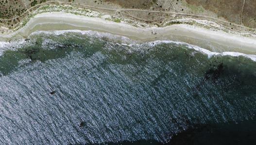
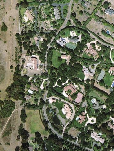
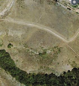
8 2 - ABOUT MORE MESA About More Mesa More Mesa is located in Santa Barbara County on the south-central coast of California. The 330-acre ocean front site lies within an unincorporated area of the Goleta Valley between the cities of Goleta and Santa Barbara, approximately 2 miles east of the University of California at Santa Barbara (Figure 2-1). More Mesa has long been recognized as one of the last and most significant undeveloped coastal open spaces on the South Coast of Santa Barbara County (County of Santa Barbara [SB County] 1993; 1982; 2002b). More Mesa is surrounded on three sides by existing residential neighborhoods: More Mesa Shores to the west; South Walnut, Mockingbird Lane, and Vieja Drive to the north, and the community of Hope Ranch to the east. The More Mesa study area consists of a broad, level coastal terrace bisected by a series of northward draining canyons and low-lying land within the floodplain of Atascadero Creek along the site s northern end (Figure 2-2). At the mesa s southern end, steep ocean bluffs rise 80 to 100 feet up to the terrace from the wide sandy beach which fronts the ocean bluffs. Terrace vegetation is primarily an expanse of gently sloping grassland, intermixed with areas of coastal scrub and occasional seasonal ponds and wetlands. Although vegetation over much of the mesa is generally open, the site s canyons and the floodplain of More Mesa s broad grasslands are bordered by Hope Ranch to the east and Goleta to the north; UCSB and Campus Point lie to the west. Atascadero Creek are dominated by dense woodlands of coast live oak, willows, and cottonwoods. As discussed later in this handbook, the variety and quality of habitats which occur within the study area support a surprising diversity of wildlife species, particularly protected and sensitive raptor species (birds of prey). As such, these habitats are recognized by the State and County as environmentally sensitive areas worthy of protection (SB County 1993; 2002b). This variety of natural resources, combined with outstanding scenic qualities, draws many recreational users to More Mesa and its undeveloped beach. As a result, although a large majority of the 330-acre study area is private land, it is traversed by numerous informal trails, providing recreation opportunities for hikers, bikers, and equestrians. Surrounding Neighborhoods - The community of Hope Ranch which borders More Mesa to the east (Figure 2-3), is comprised of large residential estate lots generally ranging from 1 to 3 acres in size which also often support equestrian uses. Areas of Hope Ranch immediately adjacent to More Mesa also contain a number of even larger parcels with many mature coast live oak and other trees, which contribute to the open and undeveloped character of the area. Access to More Mesa from this community is via an existing private trail off Via Roblata. County policy emphasizes protection of Hope Ranch s semi-rural ambience (SB County 1993). To the northeast, More Mesa is bordered by the mixed residential neighborhoods along Vieja Drive and Mockingbird Lane. Vieja Drive supports older single-family homes on lots of generally ½ to 1 acre. Mockingbird Lane supports newer planned development neighborhoods of smaller lots including Vista La Cumbre, Diamond Crest, and Las Brisas (discussed later on page 8). These neighborhoods include the three primary trails and roads used by the public to access More Mesa (see Section 3, Recreation). Development of the newer neighborhoods along Mockingbird Lane has sometimes been controversial, with public concern expressed over possible impacts to More Mesa (SB County 2002b; 2004b). More Mesa 3 Handbook
9 LEGEND City of Santa Barbara City of Goleta University of California Coastal Zone Boundary Los Padres National Forest 154 Santa Ynez Mountains 154 S A N T A B A R B A R A C O U N T Y To San Luis Obispo Ellwood Pier Ellwood Mesa 101 Devereux Slough Cathedral Oaks Hollister Avenue Road City of Goleta Los Carneros Rd. Los Carneros Lake Santa Barbara Airport Goleta Slough Isla UCSB Vista Campus Lagoon Calle Real Fairview Road 217 Rancho Goleta Lake Patterson Avenue Maria Ygnacio Creek Eastern Goleta Valley 101 Turnpike Road D rive Atascadero Creek More Mesa Hollister Avenue Puente Laguna Blanca Hope Ranch 192 State Street 225 Lauro Reservoir City of Santa Barbara 101 To Ventura N 1" = 25 MILES Goleta Point Cliff Drive 1 Santa Maria 246 Lompoc Buellton 101 SANTA BARBARA Santa Ynez COUNTY Santa Barbara Goleta Isla More Vista Mesa Carpinteria N C 1" = 600 MILES A L I F O R N I SANTA BARBARA A COUNTY P A C I F I C O C E A N SCALE IN FEET 0 7,000 14,000 N Figure 2-1. More Mesa Regional Location


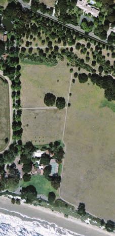


10 d oa Obern Trail Mockin gbird Lane Rh ue en v sa Atascadero Creek West Canyon Central Valley East Fork Orchid Driv e West Fork Via West Mesa East Mesa Coastal Bluff More Mesa Beach N Beach Stairway SCALE IN FEET ,000 Figure 2-2. More Mesa Physical Features Note: Blue and white lines outline general boundaries of major physical features. 5 R ob lada
11 2 - ABOUT MORE MESA This page intentionally left blank. More Mesa 6 Handbook
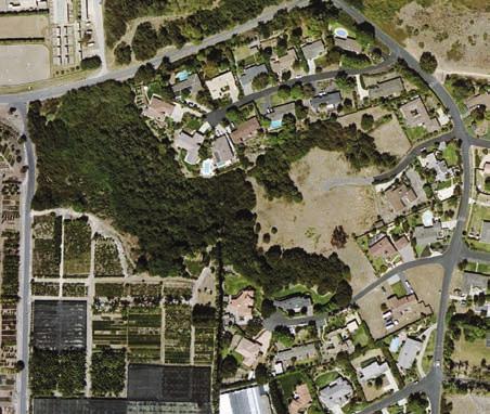
12 2 - ABOUT MORE MESA The majority of the northern edge of the More Mesa study area is defined by Atascadero Creek and the adjacent Obern Trail: a popular bike path and walking trail. Immediately north of the creek and bike trail is the 1970s-era South Walnut neighborhood, which consists primarily of single-family homes on 7,000- square foot lots and a large townhome community. More Mesa is generally inaccessible from this neighborhood due to the steep banks, flowing or standing water and mud of Atascadero Creek. It should be noted, however, that enterprising residents annually install an ad hoc plank walkway across the creek to provide limited access during low water conditions through summer and fall. West of South Walnut lies Maria Ygnacia Creek and approximately 900 acres of agricultural land cultivated in open field crops, orchard and greenhouses. This region and Maria Ygnacia Creek provide an important link between More Mesa and other area open spaces and the foothills of the Santa Ynez Mountains to the north (SB County 1993; 2002b). The More Mesa Shores neighborhood is located to the west of the study area and consists of single-family homes on lots ranging from ¼ to ½ acre in size and some agricultural uses, primarily nurseries and greenhouses. This neighborhood supports three northward draining canyons that are oak- and willowlined, similar to those found on More Mesa. Access to More Mesa from this neighborhood exists off the northern end of Orchid Drive/Shoreline Drive, a private road, while public access is available via a dirt road off the southern end of South Patterson Avenue. Land Ownership - The study area includes all of the major areas of open land south of Atascadero Creek in the vicinity which consists of approximately 330 acres of land under four different ownerships (Figure 2-3). Over 80% of the site (275 acres) belongs to three individual private owners, with the remaining parcels owned by Santa Barbara County (54 acres). The study area includes fourteen parcels (Table 2-1), with the majority of private land zoned for Planned Residential Development (PRD) and the County-owned land effectively managed as open space. The County purchased 35 acres on the mesa from private owners in 1991 for $800,000 and acquired additional land along Atascadero Creek in the mid- to late-1990s. Private ownership on More Mesa is divided between Sun Mesa, Inc. which holds the largest area of acres and owners of two smaller properties (Table 2-1). Parcel Owner (APN) Sun Mesa, Inc Table 2-1. Land Ownership on More Mesa Total Acreage Land Use and Zoning Notes Land Use: PRD Zone: PRD-70 Edward and Judith Kunda Land Use: 1 acre or more/unit Zone: DR-1 Wesley and Eileen Gray Land Use: 2 acre or more/unit Zone: DR-0.5 Santa Barbara County* Land Use: Agriculture (A-1-10); Open Lands; 0.5 acres or more/unit Zone: Agriculture (Ag-1-10); Res-40; DR-2 Majority of level mesa and canyon system. NW corner; next to More Mesa Shores. Canyon bottom next to Atascadero Creek. Hilltop, canyons, and floodplain on north end. *The different zones on county owned land reflect anticipated uses in 1993 for a park (35 acres), private agriculture 19 ± acres) and old road rightof-way (1 ± acres). Some of these zones may now be obsolete. Source: SB County History of More Mesa Due to the abundant natural resources of the Santa Ynez Mountains and Pacific coastline, the Goleta Valley historically supported relatively large Native American populations, and has been inhabited for at least 6,000 years (SB County 1992a). In the 1500s, one of the largest human settlements in Alta and Baja California was on the shores of the Goleta Slough, 1 mile west of More Mesa. However, More Mesa appears to have been used primarily for gathering and fishing, with only limited archaeological resources discovered on the mesa. These include a large flake chopper, shell and stone fragments, etc. (SB County 1992a). With the severe decline of Chumash populations, after the arrival of Spanish missionaries in the late 1700s, the mesa appears to have been used for grazing. More Mesa 7 Handbook
13 Orchid Drive 8 ORchid Drive Gray (4.5 ac) HACIENDA VIEJA Santa Barbara County (54 acres) Kunda (6 ac) Sun Mesa, Inc. (265 acres) Shoreline Drive Shoreline Drive Obern Trail Vieja Drive SOUTH WALNUT 4 VIEJA DRIVE MORE MESA SHORES MORE MESA LEGEND Parcel Boundary Coastal Zone Boundary Bike Trail Neighborhood Recent Developments (1985-Present) P A C I F I C O C E A N Figure 2-3. More Mesa Neighborhoods Rhoads Avenue Walnut Lane ad 3 1 DIAMOND CREST VISTA LA CUMBRE LAS BRISAS Mockingbird Atascadero Creek Lane Via Roblada 2 HOPE RANCH SCALE IN FEET Puente Drive N Vieja Driv


14 2 - ABOUT MORE MESA More Mesa and surrounding parcels were included in the La Goleta Ranchero in the late 1800s (Tompkins 1966). In 1846, More Mesa was deeded to Daniel A. Hill by the Mexican government and was used for cattle ranching. In 1864, Hill sold 1,000 acres that included More Mesa for $5,000 to T. Wallace More. More s 1,000-acre Goleta Ranch included orchards, as well as areas for gazing cattle and raising crops like lima beans, tomatoes, and grain. Asphalt was mined near More Mesa and this, in addition to other ranch products, was shipped from More s private pier on the west end of More Mesa. In 1886, a railroad was extended through the More Mesa property, but was abandoned by 1899 (SB County 1992a). In 1928, Mobil leased part of More Mesa to explore for oil, but In 1929, most of Goleta and all of More Mesa remained undeveloped. developed only natural gas wells on what is now the Gas Company site on west More Mesa. Grazing and limited agriculture (e.g., grains, lima beans) remained the primary use of More Mesa until the 1950s. More Mesa 9 Handbook

15 2 - ABOUT MORE MESA In 1965, the 600-unit Buena Vida development was proposed for More Mesa. However, the developer withdrew the proposal due to public opposition and his inability to acquire the parcel. In 1972, the mesa was proposed for development as the 600-unit Tyrolian Village project. However, in 1972 the California Supreme Court found that major development projects must prepare an Environmental Impact report (EIR) prior to approval (Friends of Mammoth 1972). In response, the County enacted a building moratorium and commissioned its first EIR on this More Mesa project. The developer completed the EIR and More Mesa was rezoned and approved for building; however, legal issues arose and the project was put on hold. In 1973, the Although much of More Mesa remained undeveloped, by 1986 a majority of surrounding lands had been largely developed. County denied the rezone application, effectively terminating the project. In the late 1970s approximately 265 acres of More Mesa were purchased by Columbia University which owned the land until 1984 when the property was sold to its current owner, Sun Mesa Inc. Although much of More Mesa remains undeveloped, surrounding areas have been gradually developed over the last 40 years. The South Walnut neighborhood north of More Mesa and Atascadero Creek was built in the 1960s and 1970s. The northeast corner of More Mesa was developed as Vista La Cumbre and Diamond Crest in the late 1980s. Development of this area continued with construction of the Las Brisas (2005) and Hacienda Vieja (2007). From the 1970s through the 1990s, gradual infill also continued in Hope Ranch to the east and More Mesa Shores to the west. Land Use at More Mesa More Mesa has been a focus of County planning efforts for over 28 years and is known to support wildlife, habitats, and recreational activities that are recognized as significant resources by the State (SB County 1982) 1. More Mesa was first recognized as a site of significant planning and environmental concern by the County and State in the County s 1982 Local Coastal Plan (LCP), which specifically identified the site as supporting important biological, visual and recreational resources. Although a countywide document, the 1982 LCP included site specific analysis of planning and environmental issues at More Mesa, as well as specific resource protection policies to ensure that any development respected the site s critical resources. In particular, the 1982 LCP required the preparation of a biological study, the 1982 An Evaluation of Biological Resources at More Mesa (Biological Evaluation) to thoroughly review the site s sensitive wildlife and habitat resources and to guide the location and amount of future development that could be supported on the site (refer to Section 3) 2. That study was accepted by the County in the late 1980s, when the County Board of Supervisors formally recognized approximately 260 acres of More Mesa as environmentally sensitive habitat worthy of protection. In the 1993 Goleta Community Plan (GCP), the County downzoned More Mesa, with allowable development being reduced from a maximum of approximately 312 residential units on parcels under three key ownerships (Sun Mesa, Kunda and SB County) to 76 units 3. The GCP included a new Environmentally Sensitive Habitat (ESH) map and standards which restrict new development to approximately 40 acres adjacent to Hope Ranch on the mesa s east end and 3.8 acres north of More Mesa Shores on the west end (Figures 2-3 and 2-4). The relationship between these adopted County Plans and land use and development potential on More Mesa is summarized in the following pages. 1 The County has multiple adopted countywide plans and policies contained under the umbrella of the County s 1980 Comprehensive Plan, some of which could apply to More Mesa. This report discusses only those adopted plans that are most relevant to issues surrounding resource protection and development potential on More Mesa. 2 The UCSB study was finalized in 1982; however, research and fieldwork extended from approximately 1981 to 1982 (Ferren 2008). 3 In the early 1990s, prior to adoption of the GCP, the County acquired 35 acres on the northern end of More Mesa, with subsequent acquisitions of two parcels along Atascadero Creek totaling approximately 19 acres, bringing County holdings to the current 54 acres. These County owned parcels are all effectively managed as open space. More Mesa 10 Handbook


16 2 - ABOUT MORE MESA Figure 2-4. Environmentally Sensitive Habitat Overlay, More Mesa Source: SB County Local Coastal Plan - The County s 1982 LCP included a detailed description of More Mesa and critical resources present on the site, such as oak woodlands, wetlands and significant nesting, roosting, and foraging habitat for the white-tailed kite. The 1982 LCP identified More Mesa as one of the five most significant scenic resources and one of the few remaining large ocean front parcels in the urbanized South Coast area that have not been developed. The 1982 LCP also included site specific development standards for More Mesa, including provisions that all development on the site, including structures and roads, shall be sited and designed to avoid areas used for nesting and roosting by the white-tailed kites and that in order to preserve open space and protect views to the foothills, structures shall The 1982 Local Coastal Plan recognized More Mesa for its critical biological resources and as one of the five most significant scenic resources on the South Coast. be clustered to the maximum extent possible on the northern portion of the property excluding all environmentally sensitive habitat areas. The preparation of an overall specific plan for 300 acres of More Mesa, to ensure comprehensive resource protection, was also required due to More Mesa s zoning as a Planned Residential Development (PRD). The More Mesa discussion and development standards were replaced by more detailed development standards in the 1993 GCP (see discussion below); however, all general LCP policies are still in effect and the LCP continues to identify More Mesa as significant for the white-tailed kite and provision of public recreation. In particular, existing LCP policies guide public access, view preservation and protection of ESH areas, including white-tailed kite habitat on More Mesa as outlined below: Policy 2-11: All development, including agricultural development, adjacent to areas designated on the land use plan or resource maps as environmentally sensitive habitat areas, shall be regulated to avoid adverse impacts on habitat resources. More Mesa 11 Handbook
17 2 - ABOUT MORE MESA Policy 9-28: Any development around the nest and roosting area shall be set back sufficiently far as to minimize impacts on the habitat area. Policy 9-29: In addition to preserving the ravine plant communities on More Mesa for nesting and roosting sites, the maximum feasible area shall be retained in grassland to provide feeding area for the kites. Goleta Community Plan - The GCP was adopted to address a surge in development during the late 1980s in the unincorporated community of Goleta and to provide more community specific guidance and polices than were included in the County s overall Comprehensive Plan. The GCP guides the general type and location of land uses, specifically tailored for unincorporated Goleta, including those areas within the coastal zone. All development within the unincorporated Goleta area must comply with the policies set forth in the GCP. The GCP identifies More Mesa as a unique, large, biologically diverse, scenic coastal open space of regional significance with substantial existing public use. The GCP further designates the area of More Mesa currently owned by Sun Mesa, Inc. as Planned Residential Development for up to 70 units (PRD-70). To help protect More Mesa s important biological resources, the GCP requites that these 70-units be confined to 40 acres on the mesa s eastern side, while designating approximately 264 acres of More Mesa as ESH. The purpose of the PRD designation is to protect sensitive resources, views, etc., and to ensure that development is clustered to the maximum extent feasible. Key GCP Development Standards (DevStd) include 4 : DevStd 1.1: A Specific Plan is required to provide comprehensive planning for site design and resource protection. DevStd 1.2: The property owner may request that development be increased only after approval of a new comprehensive study of the site s biological resources. 5 DevStd 1.3: Development must include a comprehensive habitat protection-management plan. DevStd 1.4: A minimum of 20% of the site must be dedicated for public use, including the bluff top. California Coastal Act: In 1972, California voters enacted Proposition 20, the California Coastal Zone Conservation Act, which the State legislature implemented through the adoption of the State Coastal Act in The Coastal Act enshrines the will of the people of the State of California and the state legislature regarding protection of significant coastal resources and provision of public access to and along the coast. The Coastal Act provides the legislative underpinning for the County s adopted LCP and contains multiple key statutes to guide development including: Section 30240: Environmentally Sensitive Habitats; adjacent developments: a) ESH areas shall be protected against any significant disruption of habitat values, and only uses dependent on those values shall be allowed within those areas; b) Development in areas adjacent to ESH areas areas shall be sited and designed to prevent impacts which would significantly degrade those areas, and shall be compatible with the continuance of those habitat areas. Section 30252: The location and amount of new development should maintain and enhance public access to the coast. Section 30251: The scenic and visual qualities of coastal areas shall be considered and protected as a resource of public importance. 4 The Kunda property, Gray property, and approximately 20 acres along Atascadero Creek, owned by the County, did not receive site specific policy guidance in the GCP. 5 The current land owner is conducting a study of the sites biological resources that is expected to be completed in More Mesa 12 Handbook
EASTERN GOLETA VALLEY COMMUNITY PLAN
 C. RESIDENTIAL LAND USES Eastern Goleta Valley is largely suburban residential in character, providing a range of residential types, including single family, condominium, apartment and mobile home types
2 PLANNING AREA DESCRIPTION
 2 PLANNING AREA DESCRIPTION 2.1 LOCATION Hecker Pass is located within the City of Gilroy near the western city limit. Figure 2-1 illustrates the regional location of the Hecker Pass Area. Figure 2-1:
5.1 AESTHETICS AND VISUAL RESOURCES Physical Setting
 5.1 AESTHETICS AND VISUAL RESOURCES 5.1.1 Physical Setting Aesthetic values are an important aspect in establishing the identity, sense of place, and quality of life in a community. Natural features in
Chapter 5: Recreation
 Chapter 5: Recreation Introduction and Setting Recreational opportunities within Nevada County are varied, ranging from public parks with intensively used active recreational facilities, to vast tracts
Arana Gulch Park Master Plan
 809 Center Street, Santa Cruz, CA 95060 Arana Gulch Park Master Plan Executive Summary The Arana Gulch Master Plan completes the last master planning work for the parks and open spaces within the City
4.1 AESTHETICS AND VISUAL QUALITY
 SCOPE AND METHODOLOGY 4.1 AESTHETICS AND VISUAL QUALITY This section evaluates the potential impacts to aesthetics and visual quality. Aesthetics refers to visual resources and the quality of what can
INTRODUCTION. 1.1 What is a General Plan? 1.2 Requirements for a General Plan. 1.3 Introduction to Monterey County
 1.1 What is a General Plan? INTRODUCTION California state law requires each city and county to adopt a comprehensive, long-term general plan for the physical development of the county or city, and any
Master Plan Objectives and Policies
 Master Plan Objectives and Policies Introduction This chapter identifies the Park issues and recommended policies established by this Master Plan. The issues were identified through meetings with staff,
Venice Pumping Plant Dual Force Main Project Draft EIR
 City of Los Angeles 5.9 LAND USE PLANS 5.9.1 Environmental Setting Venice Pumping Plant Dual Force Main Project Draft EIR The Project lies within the bounds of Los Angeles County and the City of Los Angeles.
CHAPTER 10 AESTHETICS
 CHAPTER 10 AESTHETICS CHAPTER 10 AESTHETICS This section identifies and evaluates key visual resources in the project area to determine the degree of visual impact that would be attributable to the project.
Goleta Community Plan Update
 Goleta Community Plan Update Ecology, Biology, and Habitats GVPAC Meeting Agenda [Wednesday, December 17, 2008, 6:00PM] Pledge of Allegiance and Roll Call Public Comment Period Administrative December
Policy & Procedure Effective Date: Parks Department Page of
 City of Arvada Policy & Procedure Effective Date: Parks Department Page of TITLE: City of Arvada Prairie Dog Habitat Plan APPROVAL: PURPOSE: To establish a plan for the preservation of black-tailed prairie
CHAPTER 10-D GREATER MONTEREY PENINSULA AREA PLAN
 CHAPTER 10-D GREATER MONTEREY PENINSULA AREA PLAN GREATER MONTEREY PENINSULA AREA PLAN SUPPLEMENTAL POLICIES 1.0 - Land Use GMP-1.1 GMP-1.2 GMP-1.3 GMP-1.4 GMP-1.5 GMP-1.6 GMP-1.7 GMP-18.6 The County shall
CHAPTER 10-D GREATER MONTEREY PENINSULA AREA PLAN
 CHAPTER 10-D GREATER MONTEREY PENINSULA AREA PLAN GREATER MONTEREY PENINSULA AREA PLAN SUPPLEMENTAL POLICIES 1.0 - Land Use GMP-1.1 GMP-1.2 GMP-1.3 GMP-1.4 GMP-1.5 GMP-1.6 GMP-1.7 The County shall overlay
4.1 AESTHETICS/VISUAL RESOURCES
 4.1 AESTHETICS/VISUAL RESOURCES This section provides a discussion of the visual resources in and around the project site, with an emphasis on the visual character and scenic qualities of the Gaviota Coast
III. PROJECT DESCRIPTION
 III. PROJECT DESCRIPTION A. PROJECT LOCATION Regional Setting The project site is located in the southeast quadrant of the City of Chico in Butte County, California and is comprised of four parcels totaling
The following principles guide the development of goals and strategies to protect and promote these amenities:
 OPEN SPACE/PARKS/TRAILS/RECREATION GOALS/STRATEGIES Cherry Hills Village is a living environment that offers low density development, open areas, public scenic vistas, public trails and public parks. This
3.10 LAND USE SETTING PROJECT SITE EXISTING LAND USE DESIGNATIONS AND ZONING. General Plan Land Use Designations.
 This section of the Draft EIR addresses the existing land uses on and adjacent to the project site and discusses the potential impacts of the proposed project on existing land uses. Key issues addressed
Regional Overview, Existing Jurisdictions, and Governing Land Use Plans
 4.6 LAND USE 4.6.1 Introduction This section of the EIR describes existing land uses on the North and West Campuses and analyzes the potential for implementation of the proposed project to conflict with
Santa Barbara Restoration Project Database. Cheadle Center for Biodiversity and Ecological Restoration University of California, Santa Barbara
 University of California, Santa Barbara 1 CONTENTS Introduction... 2 Setting... 2 Methods... 3 Results... 5 Discussion... 10 Conclusions... 12 2 INTRODUCTION The Santa Barbara Restoration Project Database
ADDENDUM TO BIOLOGICAL SCOPING SURVEY REPORT, BOTANICAL SURVEY AND WETLAND DELINEATION
 ADDENDUM TO BIOLOGICAL SCOPING SURVEY REPORT, BOTANICAL SURVEY AND WETLAND DELINEATION FOR AVALON INN (APN 069-241-27 & -04) 1201 & 1211 NORTH MAIN STREET FORT BRAGG, CA MENDOCINO COUNTY prepared for:
SITE INTRODUCTIONS AND OVERVIEW
 SITE INTRODUCTIONS AND OVERVIEW The City s formal Open Space Program was established in 1990 to implement long-standing policies that called for the protection of the farmlands and wild areas that surround
EASTERN GOLETA VALLEY COMMUNITY PLAN
 D. CULTURAL RESOURCES Cultural resources include but are not limited to buildings, structures, and districts, prehistoric and historic archaeological sites, historical landscapes, and traditional cultural
Authority of the General Plan
 Authority of the General Plan This La Habra Heights General Plan will serve as the blueprint for future planning and development in the City. This General Plan describes the City s vision for the future
HALF MOON BAY LOCAL COASTAL PROGRAM. d), JOHN M. St>NGER ASSOCIATES INC S.F.' CA EIOO VISUAL RESOURCES OVERLAY.
, JOHN M. St>NGER ASSOCIATES INC S.F.' CA EIOO VISUAL RESOURCES OVERLAY.") VISUAL RESOURCES OVERLAY Old Downtown Jl&& Scenic Hillsides Ocean Views from Highway 1 HALF MOON BAY LOCAL COASTAL PROGRAM d), JOHN M. St>NGER ASSOCIATES INC S.F.' CA. 94114 EIOO 217 CHAPTER 7: VISUAL
VISUAL RESOURCES OVERLAY Old Downtown Jl&& Scenic Hillsides Ocean Views from Highway 1 HALF MOON BAY LOCAL COASTAL PROGRAM d), JOHN M. St>NGER ASSOCIATES INC S.F.' CA. 94114 EIOO 217 CHAPTER 7: VISUAL
Goleta Valley Community Plan
 Goleta Valley Community Plan Initiation for board of supervisors review Part I - Eastern Goleta Valley Part II - Western Goleta Valley FEBRUARY 1, 2012* *Replaces June 1, 2011 Initiation for County Planning
Draft Gaviota Coast Plan Chapter 7: Visual Resources
 Draft Gaviota Coast Plan Chapter 7: Visual Resources 11/28/2012 Long Range Planning Division Planning and Development Department County of Santa Barbara Page Intentionally Blank Cover Photo: Gaviota Morning
Public Review Draft Oceanside Subarea Habitat Conservation Plan/ Natural Communities Conservation Plan
 Oceanside Subarea Habitat Conservation Plan/ Natural Communities Conservation Plan Prepared for City of Oceanside Planning Department 300 N. Coast Highway Oceanside, CA 92054 Prepared by Ogden Environmental
Mendota Heights 2040 Comprehensive Plan Draft Vers
 4 Parks and Trails The City of Mendota Heights boasts a variety of recreational and open space opportunities. Few cities can claim access to regional trails, riverside and lakeside parks, scenic bluffs
OPEN SPACE CHAPTER 7: OVERVIEW. Preserve open space to protect natural resources, enhance character and provide passive recreation opportunities
 CHAPTER 7: OPEN SPACE OVERVIEW Ridgefield has made tremendous progress permanently preserving areas of town as open space. Open space preservation can serve many important purposes, including: protect
This page intentionally blank.
 This page intentionally blank. Parks, Recreation, and Open Space Chapter Relationship to Vision Vision Parks, Recreation and Open Space Chapter Concepts County Government. County government that is accountable
1INTRODUCTION. Purpose of the Truckee Railyard Master Plan
 1INTRODUCTION Purpose of the Truckee Railyard Master Plan The purpose of the Truckee Railyard Master Plan is to capture and describe the Town s vision for the Railyard Area and to guide its future redevelopment.
Antioch Habitat Conservation Plan/Natural Community Conservation Plan
 Antioch Habitat Conservation Plan/Natural Community Conservation Plan Science Advisor Workshop February 8, 2018 Kathryn Gaffney Project Manager Matt Ricketts Lead Biologist 1 PRESENTATION OUTLINE Background
Project Summary. Rationale
 Modeling and Evaluating Potential Constraints Between Siting of Commercial Wind Power and Ecological and Social Values in the Mountains of the Northern Forest Principal Investigator(s): Dr. David Publicover
3.10 Land Use and Planning
 3.10 This section describes the regulatory and environmental setting for land use and planning in the program and individual project areas. It also describes impacts on land use and planning that could
BISCUIT RUN PARK MASTER PLAN
 BOARD OF SUPERVISORS November 14, 2018 BISCUIT RUN PARK MASTER PLAN COUNTY OF ALBEMARLE ANHOLD ASSOCIATES Contents Project Introduction Property Background County Park Planning Process Existing Site &
4.9 VISUAL RESOURCES Introduction
 4.9 VISUAL RESOURCES 4.9.1 Introduction This section describes the visual setting of the North and West Campuses, and evaluates the potential for changes of residential development and undeveloped area
3.11 PARKS, OPEN SPACE AND RECREATION
 3.11 PARKS, OPEN SPACE AND RECREATION This section identifies existing park, open space, and recreation resources, assesses potential impacts associated with the proposed project, and recommends mitigation
Parks, Trails, and Open Space Element
 P arks, Recreation, and Open Space are important components of the quality of life desired by the residents of Elk Grove. This Element of the General Plan addresses the City s goals, policies, and actions
EACCS Goal: provide guidelines for mitigation practices and overall conservation in east Alameda County
 EAST ALAMEDA COUNTY CONSERVATION STRATEGY: A BLUEPRINT FOR ACTION Community Meeting June 11, 2009 Agenda Welcome and Introductions Project Update o Introduction o Progress to Date o Next Steps Perspectives
ORDINANCE NO WHEREAS, the recommendations from the Pinellas County Local Planning Agency have been received and considered.
 ORDINANCE NO. 16-55 AN ORDINANCE OF THE COUNTY OF PINELLAS, AMENDING THE FUTURE LAND USE AND QUALITY COMMUNITIES ELEMENT OF THE PINELLAS COUNTY COMPREHENSIVE PLAN TO ADOPT THE CRYSTAL BEACH COMMUNITY OVERLAY;
Nob Hill Pipeline Improvements Project EIR
 Section 3.1 Aesthetics This section addresses the visual aspects that may affect the views experienced by the public, including the potential to impact the existing character of each area that comprises
Yadkin River Greenway Feasibility Study Fact Sheet Village of Clemmons, Town of Lewisville, Town of Bermuda Run
 Fact Sheet Village of Clemmons, Town of Lewisville, Town of Bermuda Run Project Background The Yadkin River Greenway Feasibility Study is a joint project with the Village of Clemmons, the Town of Bermuda
Notice of Preparation of an Environmental Impact Report and Scoping Meeting for the Canyon Lane Roadway Improvements Development Project
 of an Environmental Impact Report and Scoping Meeting for the As the Lead Agency, the County of San Mateo (County) will prepare an Environmental Impact Report (EIR) for the (project), and would like your
4.8 LAND USE AND PLANNING
 4.8 LAND USE AND PLANNING 4.8.1 INTRODUCTION This section describes existing and planned land uses at the Hayward campus and analyzes the impact of implementation of the proposed Master Plan on land uses
SECTION 3.0 PROJECT DESCRIPTION
 3.1 INTRODUCTION SECTION 3.0 PROJECT DESCRIPTION The University of California, Santa Barbara (University) proposes to implement an LRDP Amendment for the University North and West Campuses, develop 236
NOTICE OF PREPARATION
 NOTICE OF PREPARATION DATE: January 6, 2016 TO: LEAD AGENCY: Responsible Agencies, Organizations, and Interested Parties Contact: Tyler Barrington, Principal Planner Planning Department Community Development
Parks, Trails, and Open space Element
 Parks, Trails, and Open space Element Parks, Trails, and Open Space element Parks, Recreation, and Open Space are important components of the quality of life desired by the residents of Elk Grove. This
Morro Shoulderband Snail Protocol Survey Report for the Parcel at 3093 Beachcomber Drive, Morro Bay, San Luis Obispo County, California
 Morro Shoulderband Snail Protocol Survey Report for the Parcel at 3093 Beachcomber Drive, Morro Bay, San Luis Obispo County, California Prepared for: John K. Construction Inc. Prepared by: SWCA Environmental
COASTAL CONSERVANCY. Staff Recommendation June 5, 2008 SAN DIEGO RIVER TRIBUTARY CANYONS PROJECT. File No Project Manager: Megan Johnson
 COASTAL CONSERVANCY Staff Recommendation June 5, 2008 SAN DIEGO RIVER TRIBUTARY CANYONS PROJECT File No. 08-059 Project Manager: Megan Johnson RECOMMENDED ACTION: Authorization to disburse an amount not
PARKS AND RECREATION
 PARKS AND RECREATION WHAT YOU WILL FIND IN THIS CHAPTER: Background information on the development of the Park, Recreation, and System Plan (PRSP). General overview of Ellensburg s parks and recreation
Pinellas County Greenways
 Pinellas County Greenways USING GREENWAYS TO LINK OPEN SPACES The Florida Greenways Commission has defined a greenway as...a corridor of protected open space that is managed for conservation and/or recreation.
STEWARDSHIP OF LONG ISLAND SOUND S ECOLOGICAL AND RECREATIONAL RESOURCES
 STEWARDSHIP OF LONG ISLAND SOUND S ECOLOGICAL AND RECREATIONAL RESOURCES Robin Kriesberg, Save the Sound, Inc. Thomas Halavik, US Fish and Wildlife Service Coastal Program An Initiative to Identify, Protect
2.0 Hi s t o r y & Existing Co n d i t i o n s
 2.0 Hi s t o r y & Existing Co n d i t i o n s 2.1 Plan Area History The Lincoln East Specific Plan (Specific Plan) area is a significant part of the history of Sutter County. A 48,000 acre land grant
CHINO HILLS CHINO HILLS. September 6, 2012 OPEN SPACE MANAGEMENT PLAN
 September 6, 2012 Welcome! Today s Agenda Introduction Purpose and Scope of the Open Space Management Plan Where Have We Been? Presentation of Preliminary Findings Exercise: Issue identification and Priority
COASTAL CONSERVANCY. Staff Recommendation March 25, 2004 LOS ANGELES GREEN VISION PLAN. File No.: Project Manager: Marc Beyeler
 COASTAL CONSERVANCY Staff Recommendation March 25, 2004 File No.: 04-014 Project Manager: Marc Beyeler RECOMMENDED ACTION: Authorization to disburse up to $50,000 to the University of Southern California
Chapter 10 IMPLEMENTATION RECOMMENDATIONS
 Chapter 10 IMPLEMENTATION RECOMMENDATIONS The recommended land use plan presented in the previous chapter provides a design for the attainment of the urban and rural development and open space preservation
-MENDOCINO COUNTY PLANNING AND BUILDING SERVICES- DIVISION II OF TITLE 20--COASTAL ZONING CODE
 CHAPTER 20.504 VISUAL RESOURCE AND SPECIAL TREATMENT AREAS Sec. 20.504.005 Applicability. Sec. 20.504.010 Purpose. Sec. 20.504.015 Highly Scenic Areas. Sec. 20.504.020 Special Communities and Neighborhoods.
Planning Commission Report
 Planning Commission Report To: From: Subject: Planning Commission Meeting: January 6, 2016 Agenda Item: 8-B Planning Commission David Martin, Planning & Community Development Director Introduction to the
STAFF REPORT FOR STANDARD COASTAL DEVELOPMENT PERMIT #CDP FEBRUARY 26, 2015 CPA - 1 PO BOX 238 APTOS, CA 94001
 STAFF REPORT FOR STANDARD COASTAL DEVELOPMENT PERMIT #CDP 2014-0030 FEBRUARY 26, 2015 CPA - 1 OWNER/APPLICANT: AGENT: REQUEST: HANS HEIM PO BOX 238 APTOS, CA 94001 JAMES HAY PO BOX 762 MENDOCINO, CA 95460
APPENDIX A 6 CONCEPTUAL PRELIMINARY PLAN GUIDE AND CHECKLIST FOR MAJOR SUBDIVISIONS CARRBORO DEVELOPMENT GUIDE APPENDIX A
 6 CONCEPTUAL PRELIMINARY PLAN GUIDE AND CHECKLIST FOR MAJOR SUBDIVISIONS Conceptual Preliminary Guide/Checklist for Major Subdivisions Page 1 FORM: REVIEW DATE: CONCEPTUAL PLAN REVIEW 2000 REVIEWED BY:
TREASURE COAST REGIONAL PLANNING COUNCIL M E M O R A N D U M. To: Council Members AGENDA ITEM 5I
 TREASURE COAST REGIONAL PLANNING COUNCIL M E M O R A N D U M To: Council Members AGENDA ITEM 5I From: Date: Subject: Staff December 12, 2008 Council Meeting Local Government Comprehensive Plan Review Town
4.10 RECREATION Introduction
 OPEN SPACE PLAN, & LRDP AMENDMENT EIR 4.10 RECREATION 4.10.1 Introduction This section describes existing recreational resources on the University s North and West Campuses, and analyzes whether the project
Whitemarsh Township Greenway Plan
 Whitemarsh Township Greenway Plan Prepared for: Whitemarsh Township August 16, 2007 Table of Contents Table of Contents... i Introduction... 1 Study Area Setting... 2 Regional Setting... 2 Township Character...
3. VISION AND GOALS. Vision Statement. Goals, Objectives and Policies
 Vision Statement Queen Creek s interconnected network of parks, trails, open spaces and recreation opportunities provide safe and diverse activities and programs that sustain its unique, small town, equestrian
Table of Contents TABLE OF CONTENTS SECTION TITLE PAGE
 TABLE OF CONTENTS SECTION TITLE PAGE 1 INTRODUCTION AND OVERVIEW 1-1 1.1 Purpose and Need 1-1 1.2 Goals and Objectives 1-3 1.3 Overview of the Planning Process 1-5 1.4 Federal and State Requirements and
THE LAND CONSERVANCY OF SAN LUIS OBISPO COUNTY
 THE LAND CONSERVANCY OF SAN LUIS OBISPO COUNTY WWW.LCSLO.ORG WHO WE ARE Through voluntary and collaborative measures, we work to permanently protect and enhance lands having important scenic, agricultural,
Open Space Element. General Plan. County of Sacramento Community Planning and Development Department
 General Plan Open Space Element Adopted December 15, 1993 Amended November 9, 2011 County of Sacramento Community Planning and Development Department This Page blank. Table of Contents SECTION I... 1 OPEN
Community Conservation Workshop. Lake Placid
 Community Conservation Workshop Lake Placid 2 Community Conservation Program Welcome! We have designed a Community Conservation Program that listens to the needs of community members. We are conducting
APPENDIX C SPECIAL PLANNING AREAS
 SPECIAL PLANNING AREAS There are five Special Planning Areas (SPAs) on the Land Use Diagram (Figure LU-2). The SPAs are areas with significant new growth potential that require more detailed subsequent
General Location Annex, Rezone & Preliminary Plat Lansdowne Addition, Unit Three
 NEWFOUNDLAND I-5 Agricultural District Subject Site SUNDANCE ANDERSON Single Family Residential CHRISTY PUD Agricultural District Highway Business General Location Annex, Rezone & Preliminary Plat Lansdowne
Conservation Plan. I. Property Information. II. Objectives. Natural Resource Objectives. Sustainability in Practice (SIP) Certified
 Certified") Conservation Plan Sustainability in Practice (SIP) Certified I. Property Information Vineyard Name and Establishment Date: Location: Map (attach showing blocks and acres): II. Objectives Natural Resource
Conservation Plan Sustainability in Practice (SIP) Certified I. Property Information Vineyard Name and Establishment Date: Location: Map (attach showing blocks and acres): II. Objectives Natural Resource
GENERAL PLAN CONSISTENCY ANALYSIS
 GENERAL PLAN CONSISTENCY ANALYSIS Prepared by Planning Staff 10/28/2013 APPLICABLE GOALS, POLICIES AND PROGRAMS FROM the LAND USE CHAPTER Goal LU-1 Policy LU-1.1 Policy LU-1.2 Goal LU-2 Protect the character
Burrowing Owl Habitat Project at the Albany Plateau. (a component project of the Gilman Street Playing Fields Project City of Berkeley) March 10, 2006
 March 10, 2006") Burrowing Owl Habitat Project at the Albany Plateau (a component project of the Gilman Street Playing Fields Project City of Berkeley) March 10, 2006 Submitted by The City of Berkeley Project history During
Burrowing Owl Habitat Project at the Albany Plateau (a component project of the Gilman Street Playing Fields Project City of Berkeley) March 10, 2006 Submitted by The City of Berkeley Project history During
ENVIRONMENTAL INITIAL STUDY BERKELEY CITYWIDE POOLS MASTER PLAN
 ENVIRONMENTAL INITIAL STUDY FOR THE BERKELEY CITYWIDE POOLS MASTER PLAN CITY OF BERKELEY PARKS RECREATION AND WATERFRONT DEPARTMENT SEPTEMBER 1, 2009 ENVIRONMENTAL INITIAL STUDY BERKELEY CITYWIDE POOLS
CHAPTER 4 ENVIRONMENTAL SETTING AND IMPACT ANALYSIS
 CHAPTER 4 ENVIRONMENTAL SETTING AND IMPACT ANALYSIS SECTION 4.1 AESTHETICS AND VISUAL RESOURCES CHAPTER 4 ENVIRONMENTAL SETTING AND IMPACT ANALYSIS 4.1 AESTHETICS AND VISUAL RESOURCES 4.1.1 Existing
ENVIRONMENTAL SETTING
 II. ENVIRONMENTAL SETTING EXISTING CONDITIONS The 208.87-acre Project site is located in the western portion of the City (refer to Figures II-1 and II-2). The Project site comprises Assessor s Parcel Number
3.0 Cumulative Scenario and Methodology. 3.0 Cumulative Scenario and Methodology
 3.0 Cumulative Scenario and Methodology Under the CEQA Guidelines, a cumulative impact consists of an impact which is created as a result of the combination of the project evaluated in the environmental
4. ENVIRONMENTAL IMPACT ANALYSIS 7. LAND USE AND PLANNING
 4. ENVIRONMENTAL IMPACT ANALYSIS 7. LAND USE AND PLANNING 4.7.1 INTRODUCTION The following analysis discusses the consistency of the Proposed Project with the corresponding land use and zoning designations
Bull Canyon Ranch 2750 BULL CANYON ROAD, SANTA MARIA, CALIFORNIA PRESENTED FOR SALE BY: Rincon corporation
 Bull Canyon Ranch 2750 BULL CANYON ROAD, SANTA MARIA, CALIFORNIA PRESENTED FOR SALE BY: Rincon corporation THE FULL SERVICE REAL ESTATE COMPANY FOR THE AGRICULTURAL COMMUNITY Bull canyon ranch, santa maria
SANTA ROSA ISLAND RANCHING DISTRICT, CHANNEL ISLANDS NATIONAL PARK, CALIFORNIA
 DEPARTMENT OF LANDSCAPE ARCHITECTURE School of Architecture and Allied Arts University of Oregon Site Planning and Design Studio, Fall 2016 LA 489 / 589: CRN: 13477 / 13496 Professor Robert Z Melnick,
Ten Mile Creek Planning Area
 PLANNING AREA POLICIES TEN MILE CREEK Ten Mile Creek Planning Area Location and Context The Ten Mile Creek Planning Area ( Ten Mile Creek area ) is located south of the current Boise AOCI, generally south
This chapter describes the purpose of the Plan, introduces how the Plan is organized and provides contextual background for the Plan.
 Chapter 1: INTRODUCTION Purpose of a Comprehensive Plan The 2040 Comprehensive Plan establishes Medina s vision as a community and sets goals and objectives which guide future decisions and policies. The
RECREATION, OPEN SPACE AND GREENWAYS ELEMENT GOALS, OBJECTIVES, AND POLICIES
 RECREATION, OPEN SPACE AND GREENWAYS ELEMENT GOALS, OBJECTIVES, AND POLICIES GOAL R-1: DEVELOP A RECREATION, OPEN SPACE AND GREENWAYS SYSTEM AS AN INTEGRAL COMPONENT OF AN OVERALL, COUNTY-WIDE ECONOMIC
Eastern Goleta Valley Community Plan
 Eastern Goleta Valley Community Plan Adopted by the Board of Supervisors OCTOBER 20, 2015 LONG RANGE PLANNING DIVISION PLANNING AND DEVELOPMENT DEPARTMENT COUNTY OF SANTA BARBARA Coastal Zone portion not
1.0 Circulation Element
 5/9/18 1.0 Circulation Element 1.1 Introduction As growth and development occur in Apache County, enhancements to its circulation system will be necessary. With time, more roads will be paved and air and
Planning for and Managing Open Space and Natural Areas
 Planning for and Managing Open Space and Natural Areas Increasingly, development proposals in Delaware include large amounts of open space and natural areas. While open space is important as a community
Call for Artists for: Design and Construction of Environmental Art Activation Story Mill Community Park, Bozeman, MT
 Call for Artists for: Design and Construction of Environmental Art Activation Story Mill Community Park, Bozeman, MT Seeking artists to design, fabricate and install art elements in the nature sanctuary
THREE-STEP DESIGN PROCESS FOR OPEN SPACE SUBDIVISIONS
 00216106.DOC NMA/RRK 1/30/14 THREE-STEP DESIGN PROCESS FOR OPEN SPACE SUBDIVISIONS Open space subdivisions, sometimes called cluster developments, maintain a significant portion of a development site in
Regional Context Statement
 Regional Context Statement REGIONAL CONTEXT STATEMENT 3. REGIONAL CONTEXT STATEMENT In 1995, the Provincial Government passed into law the Growth Strategies Act. The purpose of this provincial initiative
LAND USE TANGLEWILDE/THOMPSON PLACE PLANNING AREA. C. Identified Neighborhood Groups and Homeowner s Associations
 LAND USE TANGLEWILDE/THOMPSON PLACE PLANNING AREA I. Profile of Tanglewilde/Thompson Place Planning Area (Revised 3/5/02) A. Location The Tanglewilde/Thompson Place Planning Area is located just east of
Master Plan for Preservation and Scenic Conservation (1995)
") 3.2 Master Plan for Preservation and Scenic Conservation (1995) The Master Plan for Preservation and Scenic Conservation was developed under the direction of the Guilford Preservation Alliance in the 1980s
3.2 Master Plan for Preservation and Scenic Conservation (1995) The Master Plan for Preservation and Scenic Conservation was developed under the direction of the Guilford Preservation Alliance in the 1980s
Draft Stillwater 2030 Comprehensive Plan- Goals and Policies
 Draft Stillwater 2030 Comprehensive Plan- Goals and Policies Instructions- Review each goal and policy and discuss with group any changes, deletions for additions to the list using your groups pen. Keep
Open Space and Recreational Facilities
 Chapter 5: Open Space and Recreational Facilities A. INTRODUCTION According to the guidelines of the 2001 New York City Environmental Quality Review (CEQR) Technical Manual, an open space analysis is necessary
2. INTRODUCTION 2.1 AUTHORITY 2.2 PURPOSE AND INTENT 2.3 SITE LOCATION
 2. INTRODUCTION 2.1 AUTHORITY The City of Gardena initiated and prepared the Artesia Corridor Specific Plan pursuant to the provisions of California Government Code, Title 7, Division 1, Chapter 3, Article
URBAN DESIGN GOALS / POLICIES / MEASURES
 URBAN DESIGN GOALS / POLICIES / MEASURES GOALS / POLICIES Authority Consideration of urban design issues in the general plan is provided under the Land Use Element requirements which direct attention to
Silverwood Masterplan Kickoff Meeting. Jim Neidhart Dane County Parks Planning
 Silverwood Masterplan Kickoff Meeting Jim Neidhart Dane County Parks Planning 608-224-3614 January 30, 2014 Silverwood County Park Public Information Meeting Notice Sent notice to all landowners adjacent
I. STAFF POLICY RECOMMENDATIONS. The following RMP policy strategies are proposed by staff in support of a Scenic Resource Protection Program:
 Policy Consideration: Scenic Resource Protection Program Status: For Consideration by the Highlands Council at September 14, 2006 Work session Date: September 12, 2006 I. STAFF POLICY RECOMMENDATIONS The
4.8 Landform Alteration and Aesthetics
 4.8 Landform Alteration and Aesthetics 4.8 LANDFORM ALTERATION AND AESTHETICS This section describes the potential environmental effects related to temporary and permanent impacts to landform and aesthetics,
Chapter 5: Natural Resources and Environment
 NATURAL RESOURCES AND ENVIRONMENT 5-1 5 Chapter 5: Natural Resources and Environment BACKGROUND AND INTENT Urban expansion represents the greatest risk for the future degradation of existing natural areas,