Removal of the Georgia and Dunsmuir Viaducts
|
|
|
- Randall Curtis
- 5 years ago
- Views:
Transcription


1 Removal of the Georgia and Dunsmuir Viaducts

2 RENDERING OF NEFC CONCEPTUAL PLAN 2

3 RENDERING OF CREEKSIDE PARK EXTENSION 3

4 RENDERING OF GEORGIA WHARF 4
5 SUMMARY OF STAFF RECOMMENDATIONS THAT Council: Approve the removal of the Georgia and Dunsmuir viaducts, and approve the Northeast False Creek Conceptual Plan (Appendix A in the report). Direct staff to complete the necessary planning, legal agreements and negotiations for the remaining NEFC lands and new waterfront parks and open space, and report back to Council in 18 months or less with the associated by-laws and policies. Approve downgrading of Prior Street to a local-serving street upon the completion of a new east/west arterial alignment to be determined through the False Creek Flats planning process and continue to pursue near-term improvements along Prior Street to continue to address community concerns about traffic-related safety. 5
). Since this time, Staff have worked to address each of Council s resolutions.")
6 ACTIONS COMPLETED SINCE 2012 In 2013, Council directed Staff to continue to undertake detailed analysis and consultations to address outstanding concerns and report back in 2 years (Dunsmuir and Georgia Viaducts and Related Area Planning Report (2013)). Since this time, Staff have worked to address each of Council s resolutions. 6

7 PUBLIC CONSULTATION SINCE

8 OVERVIEW OF TECHNICAL STUDIES COMPLETED 8

. Designed for goods movement trucks and transit buses.")

9 THE REPLACEMENT STREET NETWORK TODAY PROPOSED Replacement Street Network features: Direct two-way connection to downtown. 4 lanes on Georgia. 6 lanes on Pacific (similar to other arterials such as Cambie, Broadway and Burrard). Designed for goods movement trucks and transit buses. Sufficient capacity for today and an improved network tomorrow no net increase in community traffic in neighbouring communities. Approximately 10% reduction in traffic on Prior/Venables Street, and lower speeds. 9

10 AN IMPROVED TRANSPORTATION NETWORK TODAY PROPOSED Improved active transportation connections: A new Carrall Greenway extending from Keefer Street to the waterfront. A new path between the seawall and Quebec. A new Dunsmuir Connection to the downtown. More comfortable, convenient, accessible and enjoyable connections for People walking. People biking. People taking transit. 10

11 IMPROVED GOODS MOVEMENT The new network can: Accommodate full size goods movement trucks and transit buses. Maintain existing truck route connections while also providing additional connectivity and access options for local business. Provide more resilient and reliable connections to the downtown for goods movement and emergency service vehicles. Replace the Georgia Viaduct as part of Translink s Major Road Network. 11

12 MAJOR EVENTS The City has worked closely with the operational managers of Rogers Arena, BC Place, Costco and others to develop and test conceptual designs for the replacement street network. Short term: The proposed network provide the necessary truck access and on-street staging to support events and local business Traffic management concepts have been developed which will minimize the impacts during construction. Longer term: Improves vehicular access to NEFC. Makes it more comfortable and convenient to travel to and through the area by all modes. Improves overall pedestrian access and egress to and from the two stadiums with the new Georgia Ramp and the Dunsmuir connection. 12
.")
 Over the last 4 years the replacement network has been iteratively designed and analyzed to ensure sufficient capacity to protect adjacent communities from displaced traffic.")
13 SUMMARY OF WIDER NETWORK IMPLICATIONS Network Difference Plot, Viaducts Vs. Replacement Network The large changes in traffic flow are limited to the study area (thick lines show viaducts are removed and the new connections). Outside the study area change is negligible (east of Main St. and west of Hamilton St.) Over the last 4 years the replacement network has been iteratively designed and analyzed to ensure sufficient capacity to protect adjacent communities from displaced traffic. Traffic Flow Changes In the Future there will be new choices for people driving on the viaducts ½ of the traffic on the viaducts comes from the eastern half of the City, who will be able to use improved transit routes and better walking and cycling connections to downtown with the replacement street network. A large portion of traffic comes from the northeast sector, who will be able to use the Evergreen Line and Hastings B-Line, planned to open fall These changes will facilitate a shift from private vehicles to transit, resulting in an overall reduction in traffic and no net increase in traffic on alternate routes, including Strathcona and Grandview Woodland. Viaducts Vehicle Origins and Transit Map 13

14 CONNECTING EASTWARDS TO CLARK A new east/west arterial through the False Creek Flats is expected to: Deliver significant safety improvements for road users and railway operators. Offer a more reliable and resilient arterial road network with greater travel time reliability for goods movement and transit to and from the downtown. Allow more efficient rail movements between the False Creek Flats rail yards and goods movement facilities on the south shore of Burrard Inlet. Replace the current arterial function of Prior and Venables Street from Gore Street to Clark Drive, allowing its conversion to a local street. x 14


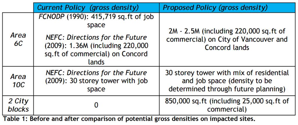
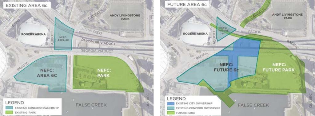
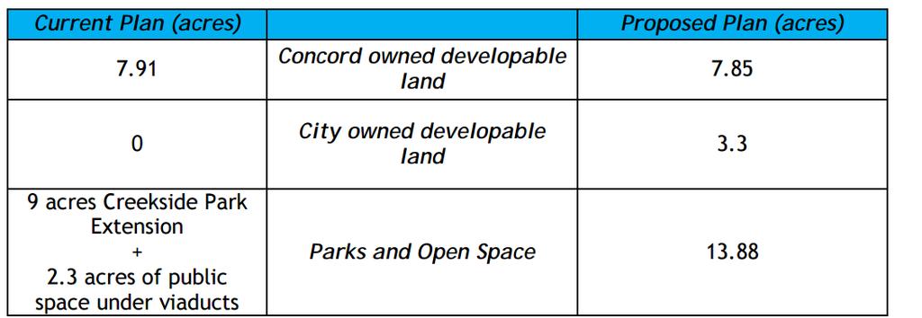
15 PARKS AND OPEN SPACE New parks and open spaces can be achieved in the area including approx. 2.7 acres on the Plaza of Nations site and a minimum of acres in the new Creekside Park Extension, Carrall Street-to- Park, and Dunsmuir Connection. A new Entertainment District will anchor the stadiums and cultural facilities in the area to the waterfront along West Georgia Street. ENTERTAINMENT DISTRICT 15

16 NEW DEVELOPMENT OPPORTUNITIES 16

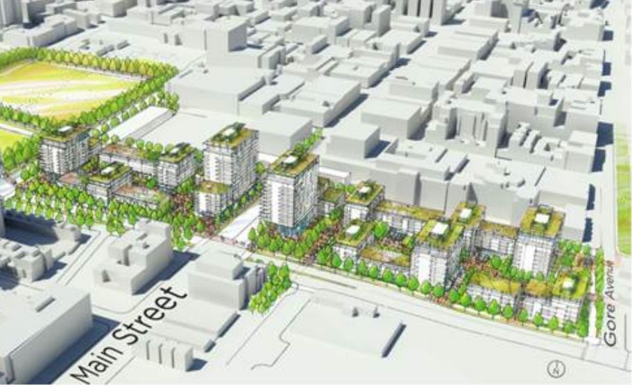
17 NEW DEVELOPMENT OPPORTUNITIES 17
18 RECONFIGURED PARCELS 18

19 COST TO RETAIN THE VIADUCTS $73 - $90 Million to keep, without any Parks, Utilities, or Adaptation Costs, including: $8 - $10 Million In Maintenance Over 15 Years $50 - $65 Million Seismic Improvements $15 Million For The Georgia Steps An additional $80 - $100 Million for end of life investment required to rehabilitate or rebuild in approximately 40 years. 19
 Net Cost = $90M - $127M Conceptual rendering of new Georgia Street Ramp 20")
20 PRELIMINARY ASSESSMENT OF COSTS & BENEFITS RELATED TO VIADUCTS REMOVAL Estimated Incremental Expenditures: $180 - $200M Expected Expenditure for Viaducts Removal, New Road Network and Related Soil Remediation Costs, Replacement of Skateboard Park and Changes to Andy Livingstone Park Deduct $73 - $90M in Avoided Costs (per previous slide, i.e. maintenance costs and seismic upgrades required for existing viaducts) Net Cost = $90M - $127M Conceptual rendering of new Georgia Street Ramp 20
21 PRELIMINARY ASSESSMENT OF COSTS & BENEFITS RELATED TO VIADUCTS REMOVAL Benefits: A preliminary estimate of at least $300 M created from: CACs DCLs (if applied) Land sale of a portion of the newly created City owned development density (west of Quebec Street) and Two blocks of City land East of Quebec freed up for development for affordable housing, and civic amenities such as a firehall. Additional City Benefits 4.75 Acres of Parks Space (In addition to the existing 9 acres already committed through the FCNODP) Other Potential Community Benefits Potential investment in Affordable Housing for this community by the Province from the Participation Mortgage Public Amenity Package The Public Benefits Package for Northeast False Creek has not yet been fully developed. Subject to public consultation, potential public benefits to serve new density could include housing, childcare, park development, and improved road network all subject to negotiation & final density. Funding strategy for this public benefits package will be developed once the final development density is approved by Council for this area. 21
22 TIMELINE OF NEXT STEPS Phase 1 Detailed planning and agreements ( ) Phase 2 Construction of Streets and portions of the new park improvements ( ) Phase 3 Construction of remaining NEFC sites and Creekside Park Extension ( ) Phase 1 ( ) Complete detailed planning, design, and the necessary agreements to advance removal of the viaducts and development of the remaining NEFC lands including areas 6C, 10C, and the future parks and open spaces. Phase 2 ( ) Construction of the new street network including the new Georgia Street ramp with 10C parkade and Pacific Blvd, seaside greenway along False Creek, and Andy Livingstone Park improvements. Phase 3 ( ) Development of NEFC areas 6C, 10C, Creekside Park Extension, and the Dunsmuir Connection. Development of the City blocks east of Quebec Street between Prior Street and Union Street. 22

23 A once in a generation opportunity. 23
24 SUMMARY OF STAFF RECOMMENDATIONS THAT Council: Approve the removal of the Georgia and Dunsmuir viaducts, and approve the Northeast False Creek Conceptual Plan (Appendix A in the report). Direct staff to complete the necessary planning, legal agreements and negotiations for the remaining NEFC lands and new waterfront parks and open space, and report back to Council in 18 months or less with the associated by-laws and policies. Approve downgrading of Prior Street to a local-serving street upon the completion of a new east/west arterial alignment to be determined through the False Creek Flats planning process and continue to pursue near-term improvements along Prior Street to continue to address community concerns about traffic-related safety. 24
General Manager of Planning and Development Services and Acting General Manager of Engineering Services. Removal of the Georgia and Dunsmuir Viaducts
 RR-1 POLICY REPORT DEVELOPMENT AND BUILDING Report Date: October 6, 2015 Contact: Brian Jackson/ Jerry Dobrovolny Contact No.: 604.873.7034/ 604.873.7331 RTS No.: 11057 VanRIMS No.: 08-2000-20 Meeting
Northeast False Creek : Past, Present and Future
 Northeast False Creek : Past, Present and Future Presentation to The Mortgage Investment Association of BC Kevin McNaney Director, Northeast False Creek Project Office Reclaiming and Reimagining Vancouver
General Manager of Planning and Development Services in collaboration with the General Manager of Engineering Services
 POLICY REPORT URBAN STRUCTURE Report Date: June 18, 2013 Contact: Brian J. Jackson Contact No.: 604.873.7043 RTS No.: 9300 VanRIMS No.: 08-2000-20 Meeting Date: June 25, 2013 TO: FROM: SUBJECT: Vancouver
HELLO & WELCOME. Prior/Venables Replacement A NEW PLAN FOR THE FALSE CREEK FLATS PLANNING PROCESS OVERVIEW
 HELLO & WELCOME. A NEW PLAN FOR THE FALSE CREEK FLATS Since last May, City staff have been working with you to identify the key issues, desires and directions for the future of the False Creek Flats. Throughout
Welcome. Rezoning Application: 1002 Station Street and Prior Street New St. Paul s Hospital and Health Campus
 Welcome Location Indicative Design Rezoning Application: 1002 Station Street and 250-310 Prior Street New St. Paul s Hospital and Health Campus The City of Vancouver has received an application to rezone
Northeast False Creek Area Plan Update. Council Update October 5, 2016
 Northeast False Creek Area Plan Update Council Update October 5, 2016 Agenda 1. Previous Council decision 2. Process update 3. Project updates 4. Next steps Northeast False Creek Area Plan Previous Council
General Manager of Planning, Urban Design and Sustainability
 RR-2(b) POLICY REPORT DEVELOPMENT AND BUILDING Report Date: June 5, 2018 Contact: Kevin McNaney Contact No.: 604.871.6851 RTS No.: 12589 VanRIMS No.: 08-2000-20 Meeting Date: June 19, 2018 TO: FROM: Vancouver
General Manager of Planning, Urban Design and Sustainability. CD-1 Rezoning: 777 Pacific Boulevard Sub-area 10C (1 Robson Street)
") RR-2(c) POLICY REPORT DEVELOPMENT AND BUILDING Report Date: June 5, 2018 Contact: Kevin McNaney Contact No.: 604.871.6851 RTS No.: 12384 VanRIMS No.: 08-2000-20 Meeting Date: June 19, 2018 TO: FROM: SUBJECT:
RR-2(c) POLICY REPORT DEVELOPMENT AND BUILDING Report Date: June 5, 2018 Contact: Kevin McNaney Contact No.: 604.871.6851 RTS No.: 12384 VanRIMS No.: 08-2000-20 Meeting Date: June 19, 2018 TO: FROM: SUBJECT:
October 19, Michael Gordon Senior Planner, Central Area Planning City of Vancouver # W. 10th Ave., V5Z 4A8
 October 19, 2009 Michael Gordon Senior Planner, Central Area Planning City of Vancouver #406-515 W. 10th Ave., V5Z 4A8 Re: North East False Creek High Level Review (report#2 of 2) Dear Michael, Thank you
WELCOME to the Northeast False Creek Area Plan Block Party and Open House
 WELCOME to the Northeast False Creek Area Plan Block Party and Open House Over the past 10 months, we have reached out to thousands of Vancouverites to talk about the future of Northeast False Creek. It
VIEW PROTECTION GUIDELINES. Adopted by City Council on December 12, 1989 Amended December 11, 1990 Corrected May 5, 2010 Amended February 1, 2011
 $1 City of Vancouver Land Use and Development Policies and Guidelines Community Services, 453 W. 12th Ave Vancouver, BC V5Y 1V4 F 604.873.7344 fax 604.873.7060 planning@vancouver.ca VIEW PROTECTION GUIDELINES
NEFC PARK DESIGN STAGE 2: CONCEPT DESIGN REPORT JAMES CORNER FIELD OPERATIONS PWL PARTNERSHIP MODUS PUBLIC
 NEFC PARK DESIGN STAGE 2: CONCEPT DESIGN REPORT PWL PARTNERSHIP MODUS PUBLIC 2 PWL PARTNERSHIP MODUS PUBLIC TABLE OF CONTENT STAGE 2 CONCEPT DESIGN REPORT i. A Park for NEFC Stage 2 Engagement Key Guiding
Thank you! Events and Entertainment in Northeast False Creek. Tuesday, March 7, 2017
 Events and Entertainment in Northeast False Creek Tuesday, March 7, 2017 Thank you! Thank you for taking the time to attend the Events and Entertainment in Northeast False Creek (NEFC) workshop in partnership
THE TOWN OF WASAGA BEACH
 THE TOWN OF WASAGA BEACH Downtown Development Master Plan Committee of the Whole Presentation January 26 th 2017 Uses within this designation should reflect a dependence on tourism as opposed to the permanent
Mississippi Skyway Preliminary Engineering Report
 EXECUTIVE SUMMARY Mississippi Skyway Preliminary Engineering Report CITY OF RAMSEY, MINNESOTA DECEMBER 2014 City of RAMSEY EXECUTIVE SUMMARY Project Need and Intent The Mississippi Skyway pedestrian bridge
VANCOUVER CONVENTION AND EXHIBITION CENTRE (VCEC) CD-1 GUIDELINES THURLOW STREET. Adopted by City Council November 5, 2002
 CD-1 GUIDELINES THURLOW STREET. Adopted by City Council November 5, 2002") $2 Land Use and Development Policies and Guidelines Community Services, 453 W. 12th Ave Vancouver, BC V5Y 1V4 F 604.873.7344 fax 873.7060 planning@city.vancouver.bc.ca VANCOUVER CONVENTION AND EXHIBITION
$2 Land Use and Development Policies and Guidelines Community Services, 453 W. 12th Ave Vancouver, BC V5Y 1V4 F 604.873.7344 fax 873.7060 planning@city.vancouver.bc.ca VANCOUVER CONVENTION AND EXHIBITION
North Macadam Transportation Development Strategy Summary of Past Studies DRAFT
 North Macadam Transportation Development Strategy Summary of Past Studies DRAFT Several previous studies were reviewed to gain an understanding and document the recent transportation issues in the North
Stockton Waterfront Master Plan. Waterfront Master Plan
 Stockton Waterfront Master Plan Presentation Objectives Process update Planning observations Planning Goals Planning Principles Review of planning activities Summary and next steps Planning Activities
New Westminster Downtown Parking Strategy Public Open House #1 September 13, 2012
 New Westminster Downtown Parking Strategy Public Open House #1 September 13, 2012 The City is preparing a strategy for parking in Downtown New Westminster. The study team and a group of key stakeholders
Rezoning Frequently Asked Questions
 elcome The City of Vancouver has received an application to rezone 6929-6969 Cambie Street and 515 est 54th Avenue from RS-1 (Single Family) District to CD-1 (Comprehensive Development) District. The proposal
Welcome to the Oakridge Centre Open House
 Welcome to the Oakridge Centre Open House Why is the City hosting this event? This open house is to inform you of a rezoning application submitted to the City of Vancouver to amend the existing CD-1 (Comprehensive
WELCOME WHY A TEMPORARY PATHWAY? WE WANT TO HEAR FROM YOU
 WELCOME In March, the City of Vancouver purchased the lands known as the Arbutus Corridor from Canadian Pacific Railway for the purpose of creating a transportation corridor from False Creek to the Fraser
Planning Commission March 14, Presented by: City of Bellingham Port of Bellingham
 Planning Commission March 14, 2013 Presented by: City of Bellingham Port of Bellingham 1 Agenda Waterfront District Background Waterfront District Proposal Overview Sub-area Plan Development Regulations
October 25 Downtown Partnership and Action Plan Workshop Record of Group Table Results
 October 25 Downtown Partnership and Action Plan Workshop Record of Group Table Results During the October 25 workshop, participants were asked to rank their top priorities for the Downtown Action Plan.
Jim Harkins DUNDEE WATER FRONT CIRCULATOR DUNDEE WATER FRONT CIRCULATOR. Specialists in Affordable & Sustainable Tramways. A short presentation by
 DUNDEE WATER FRONT CIRCULATOR DUNDEE WATER FRONT CIRCULATOR A short presentation by Jim Harkins Light Rail (UK) Specialists in Affordable & Sustainable Tramways www.lightrailuk.com E-mail Lightrailuk@aol.com
CITY CORE 2050 A VISION FOR THE HEART OF THE REGION
 CITY CORE 2050 A VISION FOR THE HEART OF THE REGION INITIAL SCOPE OF WORK OCTOBER 17, 2017 CITY CORE 2050 Phase 1 January to July 2018 A public conversation about challenges and opportunities A preliminary
The Master Plan Framework
 The Master Plan Framework The East Harbour Master Plan advances the development of 60 acres of former industrial lands east of the Don River. The Master Plan outlines a vision for a vibrant, transit-oriented
East River Waterfront Esplanade and Piers New York, New York Draft Environmental Impact Statement
 East River Waterfront Esplanade and Piers New York, New York Draft Environmental Impact Statement October 12, 2006 CEQR No.: TO COME ULURP Nos.: TO COME Lead Agency: Lower Manhattan Development Corporation
The transportation system in a community is an
 7 TRANSPORTATION The transportation system in a community is an important factor contributing to the quality of life of the residents. Without a sound transportation system to bring both goods and patrons
Northwest Rail Corridor and US 36 BRT Development Oriented Transit Analysis 4.4 STATION AREA FINDINGS
 4.4 STATION AREA FINDINGS Each station is different, and each one requires a separate set of recommendations based on the vision for the site. This section outlines an initial TOD strategy and recommendations
Vancouver Towers + Podiums. West End to Abu Dhabi
 Vancouver Towers + Podiums West End to Abu Dhabi What is the major issue that the City of Vancouver is dealing with in the next five to ten years? What is the City of Vancouver s Vision for growth? How
Southern Gateway Project and Public Green
 Southern Gateway Project and Public Green Transportation and Trinity River Project Committee May 23, 2016 Purpose of Presentation Provide the history and an overview of the Southern Gateway Project (SGP)
WEST END CURRENT ST. PAUL S SITE BURRARD ST NELSON ST GRANVILLE ST 400M
 1.3 Site Context 1.3.1 Strategic Location Figure 1-10: Location of the New St. Paul s Hospital The most significant opportunity and original driver for selecting the Station Street site as the ideal location
Hastings Park-PNE Public Board Meeting March 4, 2019
 Hastings Park-PNE Public Board Meeting March 4, 2019 Agenda 1. Review of Projects to date 2. Update on Master Plan Projects Playland Redevelopment Amphitheatre Renewal 3. Hastings Park Technical Studies
Shift Rapid Transit Public Participation Meeting May 3, 2017
 Shift Rapid Transit Public Participation Meeting May 3, 2017 Shift Rapid Transit Initiative Largest infrastructure project in the city s history. Rapid Transit initiative will transform London s public
New St. Paul s Hospital and Health Campus. PHASE 1: Guiding Principles CONSULTATION SUMMARY. April 2016
 New St. Paul s Hospital and Health Campus PHASE 1: Guiding Principles CONSULTATION SUMMARY April 2016 Table of Contents Background... 1 Project timeline... 1 Phase 1 Public Consultation... 2 Phase 1 Metrics...
THAT the Board endorse the Parks, Open Spaces, and Recreation Capital Plan as outlined in this report. Total $154.5M:
 Date: September 24, 2014 TO: Board Members Vancouver Park Board FROM: General Manager Parks and Recreation SUBJECT: 2015-2018 Final Capital Plan RECOMMENDATION THAT the Board endorse the 2015-2018 Parks,
Report Date: April 24, 2014 Contact: Kent Munro Contact No.: RTS No.: VanRIMS No.: Meeting Date: May 13, 2014
 POLICY REPORT DEVELOPMENT AND BUILDING Report Date: April 24, 2014 Contact: Kent Munro Contact No.: 604.873.7135 RTS No.: 10569 VanRIMS No.: 08-2000-20 Meeting Date: May 13, 2014 TO: FROM: SUBJECT: Vancouver
The River Hub: NEW BUILDINGS
 Summary The River Hub includes 6 municipalities that all boarder the Fraser River. Combined, they are expected to double in population over the next 50 years. To accommodate this new population, 138,831
MURRAY CENTRAL STATION MASTER PLAN Central Station Area of Influence and Site Analysis
 CENTRAL STATION MASTER PLAN Central Station Area of Influence and Site Analysis OVERVIEW Planned Fire Station TAYLORSVILLE A thorough Site Analysis was conducted to ensure planning and design concepts
Bloor Street East Potential Ravine Portal Overlook and Access Passage to the Rosedale Valley and Don River Valley Ravine, Toronto, Canada
 TRANSFORMATIVE IDEA 2. GREAT STREETS Bloor Street Christie Pits Park Bloor St Spadina Ave Bathurst St Shaw St 1 Recognize the significant public realm improvements along Bloor Street and extend and enhance
CHAPTER 7: Transportation, Mobility and Circulation
 AGLE AREA COMMUNITY Plan CHAPTER 7 CHAPTER 7: Transportation, Mobility and Circulation Transportation, Mobility and Circulation The purpose of the Transportation, Mobility and Circulation Chapter is to
Vancouver s Innovation Economy
 Vancouver s Innovation Economy 1 hat is an Innovation Economy? The innovation economy is a bit different in every city. Vancouver has its own unique mix of diverse economies which include: highly specialised
AvalonBay Communities + BRIDGE Housing. Mission Housing Habitat for Humanity Pacific Union Development Corporation
 AvalonBay Communities + BRIDGE Housing Mission Housing Habitat for Humanity Pacific Union Development Corporation Tonight s Agenda Recap of discussion from last CAC meeting Updates on meetings with Stakeholders
CRYSTAL CITY BLOCK PLAN # CCBP- G 1 DRAFT
 CRYSTAL CITY BLOCK PLAN # CCBP- G 1 DRAFT BLOCK G (Metro Market Square block) Long Range Planning Committee Meeting January 29, 2018 1 1. Introduction 2 1. LRPC Meeting Purpose Review of proposed Crystal
BeltLine Corridor Environmental Study
 BeltLine Corridor Environmental Study Citywide Conversation on Transit and Trails April 2, 2009 Agenda & Introductions Introductions Environmental Study Process Overview of the BeltLine Project BeltLine
Regency Developments. Urban Design Brief. Holyrood DC2 Rezoning
 Regency Developments Urban Design Brief Holyrood DC2 Rezoning Stantec Consulting Ltd. 7-31-2017 1. Overview Regency Developments intends to rezone the lands located at 8510 and 8511 93 Avenue, within the
Phase I Redevelopment Plan. First Community Meeting
 Hoboken Terminal and Yard Phase I Redevelopment Plan First Community Meeting May 31, 2011 One Hudson Place Phase I Redevelopment Plan Redevelopment Plan First Community Meeting Agenda 1. Redevelopment
BROADWAY-ARBUTUS POLICIES. Adopted by City Council on July 7, NOTE: To be considered in combination with applicable guidelines
 50 City of Vancouver Land Use and Development Policies and Guidelines Community Services, 453 W. 12th Ave Vancouver, BC V5Y 1V4 F 873.7344 fax 873.7060 planning@city.vancouver.bc.ca BROADWAY-ARBUTUS POLICIES
Don Mills Crossing Study and Celestica Lands Development Application Community Meeting, Open House, and Breakout Discussions
 Consultation Summary Don Mills Crossing Study and Celestica Lands Development Application Community Meeting, Open House, and Breakout Discussions This report is not intended to provide a verbatim transcript
Planning for TOD Implementation at a Corridor Scale
 Planning for TOD Implementation at a Corridor Scale Catherine Cox Blair, Reconnecting America Presentation to DRCOG and the Sustainable Communities Initiative May 14, 2012 What is Reconnecting America?
[FORMALLY ADOPTED AS GUIDELINES FOR SITING AND MASSING BUILDINGS ADJACENT TO DOWNTOWN VANCOUVER BRIDGEHEADS ] 1 Application and Intent...
![[FORMALLY ADOPTED AS GUIDELINES FOR SITING AND MASSING BUILDINGS ADJACENT TO DOWNTOWN VANCOUVER BRIDGEHEADS ] 1 Application and Intent...](/thumbs/77/76598648.jpg "[FORMALLY ADOPTED AS GUIDELINES FOR SITING AND MASSING BUILDINGS ADJACENT TO DOWNTOWN VANCOUVER BRIDGEHEADS ] 1 Application and Intent...") $1 City of Vancouver Land Use and Development Policies and Guidelines Community Services, 453 W. 12th Ave Vancouver, BC V5Y 1V4 F 873.7344 fax 873.7060 planning@city.vancouver.bc.ca BRIDGEHEAD GUIDELINES
$1 City of Vancouver Land Use and Development Policies and Guidelines Community Services, 453 W. 12th Ave Vancouver, BC V5Y 1V4 F 873.7344 fax 873.7060 planning@city.vancouver.bc.ca BRIDGEHEAD GUIDELINES
This Review Is Divided Into Two Phases:
 Semiahmoo Town Centre Review The purpose of this review: To review the Semiahmoo Town Centre Concept Plan, originally approved in 1993, to ensure that this centre will continue to serve the needs of South
1 INTRODUCTION Purpose Project Background PROJECT CONTEXT Background The Capital City Downtown Plan...
 Attachment 3 Contents CONTENTS 1 INTRODUCTION... 3 Purpose... 3 Project Background... 3 2 PROJECT CONTEXT... 9 Background... 9 The Capital City Downtown Plan... 9 The LRT Expansion Plan - LRT Downtown
DRAFT Civic Center Station Area Plan. Executive Summary
 DRAFT Civic Center Station Area Plan Executive Summary This project is funded in part through the Metropolitan Transportation Commission s Station Area Planning Program. The preparation of this report
EXHIBIT A. Tax Increment Reinvestment Zone No. 1 (Town Center) First Amended Project Plan 1
 First Amended Project Plan 1") EXHIBIT A Tax Increment Reinvestment Zone No. 1 (Town Center) First Amended Project Plan 1 1 As amended by Resolution No. 2008-02-001(TR1R) of the Tax Increment Reinvestment Zone No.1, and approved to
EXHIBIT A Tax Increment Reinvestment Zone No. 1 (Town Center) First Amended Project Plan 1 1 As amended by Resolution No. 2008-02-001(TR1R) of the Tax Increment Reinvestment Zone No.1, and approved to
Johnson Street Bridge Public Realm Update
 Johnson Street Bridge Public Realm Update August 20, 2015 Background Johnson Street Bridge Replacement Project impacts a diverse range of stakeholders In addition to a new bridge, the project also includes
Town of Portola Valley General Plan. Nathhorst Triangle Area Plan
 Town of Portola Valley General Plan Amended December 10, 1997 Table of Contents Introduction... 1 Planning Area... 1 Objectives... 2 Principles... 2 Standards... 4 Description... 4 Community Commercial...
North Downtown Specific Plan MEMORANDUM
 North Downtown Specific Plan MEMORANDUM MEETING DATE: November 13, 2017 TO: Members of the North Downtown Specific Plan Advisory Committee FROM: Jeanine Cavalli, Senior Planner SUBJECT: Materials for the
TOWN OF NEW CASTLE - Master Plan Update
 Our Presentation Today (1) Recap the Master Planning Process To Date (2) Present the Outline of the Master Planning Work Plan (3) Present the Calendar for the Master Plan (4) Outline the scope of a Downtown
Table L-1 Summary Action Strategy. Action Item Timing Status Responsible Agency
 CHAPTER 4: CIRCULATION ELEMENT ISSUE #1: MAJOR THOROUFARES AND TRANSPORTATION ROUTES A balanced transportation system for Fontana is provided that meets the mobility needs of current and future residents
Issues Requiring Future Study
 Issues Requiring Future Study Transportation planning is an ongoing process that tends to identify new issues as it finds solutions for others. Some issues are so complex that a solution to one problem
John M. Fleming Managing Director, Planning and City Planner. Old East Village Dundas Street Corridor Secondary Plan Draft Terms of Reference
 Report to Planning and Environment Committee To: From: Subject: Chair and Members Planning & Environment Committee John M. Fleming Managing Director, Planning and City Planner Old East Village Dundas Street
Enhanced Planning Process
 Welcome The City of Vancouver has received an application to rezone 725-747 Southeast Marine Drive from CD-1 (Comprehensive Development) District to a revised CD-1 District By-law. The proposal is for
LEED-ND 101: Practical Strategies for Achieving Sustainability Goals. Travis Parker Lakewood Planning Director
 LEED-ND 101: Practical Strategies for Achieving Sustainability Goals Travis Parker Lakewood Planning Director Metro Vision Idea Exchange Oct 11, 2012 West Corridor Stations West Corridor Overview West
Little Mountain Policy Statement. Presentation on Draft Urban Design Policies April 3, 2012
 Little Mountain Policy Statement Presentation on Draft Urban Design Policies April 3, 2012 OVERVIEW Holborn Concept Site Plan Four Perspectives 1. Context: Place in the city 2. Transition: Relationship
Guiding Principles, Objectives, Strategies and Policies
 Guiding Principles, Objectives, Strategies and Policies Section 1 Introduction These Guiding Principles were adopted as part of the 1999 Athens-Clarke County Comprehensive Plan and are carried over, in
Introduction. Intent of the Plan. Urban Design and Land Use Approach
 Introduction Intent of the Plan This is the Second Public Open House for the. The intent of the is to update current City policy in order to encourage future development that will ensure a diverse, lively,
Planning for TOD Implementation at a Corridor Scale
 Planning for TOD Implementation at a Corridor Scale Bill Sadler, Reconnecting America Presentation to Gold Line Corridor Working Group July 2, 2013 What is Reconnecting America? Reconnecting America is
Welcome! MILLENNIUM LINE BROADWAY EXTENSION. Over the next 30 years, Metro Vancouver will welcome 1 million new residents and 600,000 new jobs.
 WELCOME Welcome! MILLENNIUM LINE BROADWAY EXTENSION Over the next 30 years, Metro Vancouver will welcome 1 million new residents and 600,000 new jobs. The Broadway Corridor is home to the second largest
Key Themes and Responses May 2016
 King and Victoria Transit Hub and Waterloo Street Pedestrian Access Key Themes and Responses May 2016 The following summarizes what Regional staff heard about the King Victoria Transit Hub and Waterloo
Developer s Program. The Station at East 54
 Developer s Program The Station at East 54 Existing Conditions The Station at East 54 is proposed for a 1.12 acre site at the northeast corner of Hamilton Road and Prestwick Road, tucked between the East
Engagement Summary Gastown Streets: Local Business Visioning Workshop
 Engagement Summary Gastown Streets: Local Business Visioning Workshop Gastown s streets are in need of major repair and rehabilitation and we have a once in a lifetime opportunity to holistically plan
C. Westerly Creek Village & The Montview Corridor
 C. Westerly Creek Village & The VISION Community Vision When the goals of the city are achieved Westerly Creek Village, a distinctive community defined by Montview Boulevard and Westerly Creek, is a strong
Crofton Manor 2803 West 41st Avenue WHAT WE HEARD. Public Consultation: Phase 1
 Crofton Manor 2803 West 41st Avenue WHAT WE HEARD Public Consultation: Phase 1 Background CROFTON MANOR What s Happening The City of Vancouver is undertaking a planning and public engagement process to
Gold Line Bus Rapid Transit Transit Oriented Development (BRTOD) Helmo Station Area Plan
 Helmo Station Area Plan") Appendix F Gold Line Bus Rapid Transit Transit Oriented Development (BRTOD) Helmo Station Area Plan Introduction and Purpose of the Plan The Gold Line Bus Rapid Transit facility is an eleven-mile dedicated
Appendix F Gold Line Bus Rapid Transit Transit Oriented Development (BRTOD) Helmo Station Area Plan Introduction and Purpose of the Plan The Gold Line Bus Rapid Transit facility is an eleven-mile dedicated
CITY OF FARGO PARKING RAMP SITE EVALUATION
 CITY OF FARGO PARKING RAMP SITE EVALUATION EXECUTIVE SUMMARY Helenske Design Group (architect) and Carl Walker Inc (Parking Consultant) were retained by the City of Fargo to complete a downtown parking
SECTION ONE: INTRODUCTION. introduction
 introduction 1 INTRODUCTION Since it was first established in 1843 as a trading post for the Hudson s Bay Company, Victoria has evolved into a Provincial capital city that is recognized across Canada and
New Partners for Smart Growth Conference February 5, 2010
 Dan Stroh, Planning Director City of Bellevue Planning and Community Development Bellevue, WA New Partners for Smart Growth Conference February 5, 2010 Summary of Project Long-range plan update for Bel-Red
Honorable Mayor and Members of the City Council. Submitted by: Eric Angstadt, Director, Planning and Development
 Office of the City Manager ACTION CALENDAR January 29, 2013 To: From: Honorable Mayor and Members of the City Council Christine Daniel, City Manager Submitted by: Eric Angstadt, Director, Planning and
Thank you for coming to the Rail Corridor Land Use Study Public Meeting.
 01 Welcome! Thank you for coming to the Rail Corridor Land Use Study Public Meeting. Tonight is an opportunity to learn about the Land Use Study for the Rail Corridor Site. In Fall 2016, Toronto City Council
Integrated Urban Development. April Reflections from the NZPI Study Tour of Portland, Seattle and Vancouver
 Integrated Urban Development April 2009 Reflections from the NZPI Study Tour of Portland, Seattle and Vancouver Integrated Urban Development Urban Growth Management Transportation Transit Orientated Mixed
Downtown Dubuque...it s a great time.
 Downtown Dubuque...it s a great time. Your timing could not be better to invest in Downtown. With hundreds of millions in public and private investment occurring on the City s downtown waterfront, millions
Sustainable Development Call for Projects
 Sustainable Development Call for Projects 2005-2006 Infrastructure Project Examples *Note: This list is not all inclusive, but a sampling of the types of projects that were awarded funds. 137 Projects
General Manager of Planning and Development Services
 POLICY REPORT DEVELOPMENT AND BUILDING Report Date: October 16, 2013 Contact: Matt Shillito Contact No.: 604.871.6431 RTS No.: 10235 VanRIMS No.: 08-2000-20 Meeting Date: October 23, 2013 TO: FROM: SUBJECT:
WELCOME! WHAT IS A GREENWAY?
 WELCOME! In March 2016, the City of Vancouver purchased 42 acres of land from Canadian Pacific Railway for the purpose of creating a high-quality public space for walking, cycling and wheeling. Streetcar
2009 Community Excellence Award DOWNTOWN LANGLEY MASTER PLAN
 2009 Community Excellence Award DOWNTOWN LANGLEY MASTER PLAN A Multi-Phased Strategy for Economic, Physical, and Social Growth Category: Leadership & Innovation, Large Community LAND USE AND PLANNING Submitted
Link Union Station (Link US) Project Open House September 26, 2018
 Project Open House September 26, 2018") Link Union Station (Link US) Project Open House September 26, 2018 Major Project Components 1. New rail communication, signals, and tracks 2. New run-through tracks over US-101 and new loop track 3. New
Link Union Station (Link US) Project Open House September 26, 2018 Major Project Components 1. New rail communication, signals, and tracks 2. New run-through tracks over US-101 and new loop track 3. New
Comprehensive Plan ADOPTED APRIL 2014
 Comprehensive Plan ADOPTED APRIL 2014 8 8. Outstanding Recreational & Cultural Opportunities We are proud of our community s parks and recreation system. Our community will ensure that the legacy of our
DRAFT ROOSEVELT ROAD. District Recommendations. Figure 5.23 The Roosevelt Road Corridor
 CHAPTER 5 Figure 5.23 The Road Corridor Road will develop as a mixed-use corridor, emphasizing regional retail, west of the river and mixed-use development east of the river. KEY RECOMMENDATIONS 1. High
WELCOME TO OPEN HOUSE TWO November 28, 2018
 Langstaff Road Weston Road to Highway 7 Class Environmental Assessment Study WELCOME TO OPEN HOUSE TWO November 28, 2018 Please sign in and join our mailing list Study Overview York Region is conducting
Emery Village Road 2A Municipal Class Environmental Assessment Study
 PW12.11 STAFF REPORT ACTION REQUIRED Emery Village Road 2A Municipal Class Environmental Assessment Study Date: March 30, 2016 To: From: Wards: Reference Number: Public Works and Infrastructure Committee
Summary of Public Input & Discussion of Alternatives
 Meeting #4 Summary of Public Input & Discussion of Alternatives May 6 th, 2009 City of Bellingham, Washington April 1 April 15 April 22 May 6 Introduction, Character and Boundary Study Areas Public Realm:
City of Toronto Official Plan Indicators
 City of Toronto Official Plan Indicators Attachment 1 2017 Gladki Planning Associates in association with Hemson Consulting & Studio Jaywall City of Toronto Official Plan Indicators 1 Introduction What
Speers Road Corridor Study. Livable Oakville (Official Plan) Council Sub Committee March 20, 2017
 Council Sub Committee March 20, 2017") Speers Road Corridor Study Livable Oakville (Official Plan) Council Sub Committee March 20, 2017 Overview 1) Study Purpose & Background 2) Study Area 3) Policy Context and Plan Review 4) Speers Road Corridor
Speers Road Corridor Study Livable Oakville (Official Plan) Council Sub Committee March 20, 2017 Overview 1) Study Purpose & Background 2) Study Area 3) Policy Context and Plan Review 4) Speers Road Corridor
CHAPTER 8 ISSUES, CONCERNS, CONSTRAINTS AND OPPORTUNITIES
 CHAPTER 8 ISSUES, CONCERNS, CONSTRAINTS AND OPPORTUNITIES Introduction This River Conservation Plan was developed during a time of tremendous activity and effort in planning the transformation of the Delaware
Item PZ South Lindbergh Project Overview
 Item PZ-042517-01 2001 South Lindbergh Project Overview Project consists of a redevelopment of 2001 South Lindbergh Boulevard, the former Shriner s Hospital site. The site contains 14.871 Acres. The proposed
APPENDIX C SPECIAL PLANNING AREAS
 SPECIAL PLANNING AREAS There are five Special Planning Areas (SPAs) on the Land Use Diagram (Figure LU-2). The SPAs are areas with significant new growth potential that require more detailed subsequent
CONTEXT: the Highway, the River + the Railroads run through us.
 CONTEXT: the Highway, the River + the Railroads run through us. I-25 36 In the past they have divided us, now we have an opportunity to unite us. I-76 I-270 I-76 CSU I-25 LEGEND Cut + Cover River North
Downtown Sudbury. Implementation Plan. City Council
 Downtown Sudbury Implementation Plan City Council 08.14.12 Thirty Year Master Plan 18 Projects: Retail Strategy and Growth Friendship Centre Retrofit Place des Arts Franklin Carmichael Art Gallery Farmers