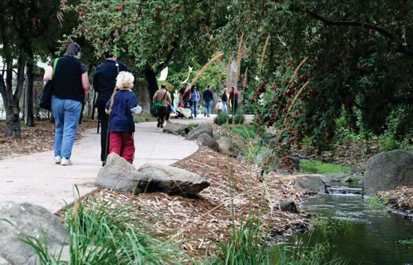
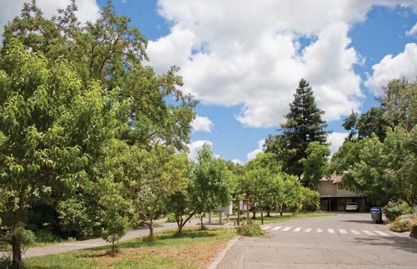
Appendix B. Best Practices. Retrofit of an Existing Park. 1. Improving Existing Parks. Best Practices Catalog 6/6/2013. Dixieanne Park, Sacramento
|
|
|
- Georgina Jefferson
- 5 years ago
- Views:
Transcription

 Community Gardens New")

 Integrated Stormwater Management (Reducing")

 Best Practices www.elcerritourbangreening.org Retrofit of an Existing Park 1.")
1 Appendix B Best Practices Catalog 6/6/ Improving Existing Parks Retrofit Existing Parks Multi-Function and Multi-Use High Use Facilities Activities Grouped Into Settings Adding Play in a Natural Context Maintenance Friendly Joint Use Facilities 2 Creating Diverse New Open Spaces School Yards--> "Schoolyard Parks" Parking Lots--> flexible open spaces Creeks (connectivity, attractive sites for parks, trails) Community Gardens New Neighborhood Park & Playgrounds in Underserved Areas Utility Corridors 3 Improving Existing Right of Way (ROW) Improving Access & Connectivity Bike Facilities Trails, Stairs and Paths Improving Sidewalks 4 Repurposing Street ROW Flexible Lanes Pavement to Parks & Plazas Community Gardens Play Areas 5 Integrating Green Infrastructure Regenerative Landscape (Soil, Water and Bay Area Friendly Planting) Integrated Stormwater Management (Reducing Impervious Surface, Planters, etc) Water Management (Irrigation, Recycled Water, etc) Material Production + Energy Harvesting Improving Environmental Benefits Through Materials 6 Building Social Infrastructure Support Maintenance of Parks, Greenways/ Trails, Improved ROWs Support Community Building (Strong Neighborhoods & Commercial Areas, Community Identity) Best Practices Retrofit of an Existing Park 1. Improving Existing Parks Dixieanne Park, Sacramento


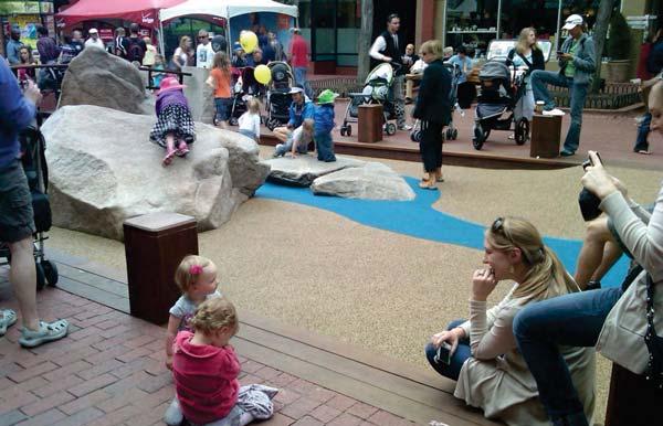
2 Retrofit of an Existing Park Multi-functional and Multi-user POGO Park (Elm Park), Richmond Jamison Square, Portland High Use Facilities Activities Grouped Into Settings


3 Adding Play in a Natural Context Maintenance Friendly Joint Use Facilities 2. Creating Diverse, New Open Spaces Glendale Edison School, Pacific Park


4 Schoolyard to Schoolyard Parks Schoolyard to Schoolyard Parks SFUSD SFUSD Parking Lots to Flexible Open Spaces Creeks (connectivity, attractive sites for parks, trails) Schenley Plaza, Pittsburg Baxter Creek, El Cerrito
 Parking Lot, North")

 for parks,")

5 Creeks (connectivity, attractive sites for parks, trails) Parking Lot, North Park Theater Parking Lots to Flexible Open Spaces Baxter Creek, El Cerrito North Park Theater Parking Lot, San Diego Creeks (connectivity, attractive sites for parks, trails) Creeks (connectivity, attractive sites for parks, trails) Rockridge Temescal Greenbelt, Oakland Rockridge Temescal Greenbelt, Oakland


6 Community Gardens New Neighborhood Park in Underserved Area Doyle Hollis Park, Emeryville Utility Corridor to Trails Utility Corridor to Trails West San Gabriel River Utility Corridor West San Gabriel River Utility Corridor


7 Improving Access & Connectivity 3. Improving Existing Street Right-of-Way Green Lane, Long Beach Improving Access & Connectivity 50% Improving Access & Connectivity 300% 100% Green Lane, Long Beach Green Lane, Long Beach
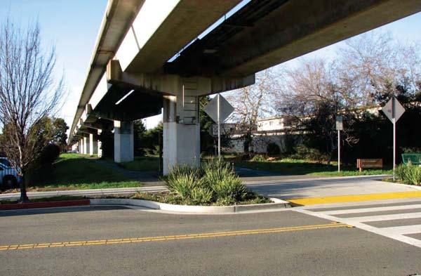


8 Improving Connectivity Trails, Stairs, etc Improving Connectivity Trails, Stairs, etc Ohlone Greenway, El Cerrito Improving Connectivity - Trails, Stairs, etc Sidewalks


9 Sidewalks Sidewalks (Sometimes, all it takes is a ping pong table ) Flex Lanes 4. Repurposing Street Right-of-Way Mountain View


10 Pavement to Parks & Plazas Pavement to Parks & Plazas Upper Market, San Francisco Upper Market, San Francisco Pavement to Parks & Plazas Community Gardens Los Angeles Gilman Gardens, Seattle


11 Community Gardens Gilman Gardens, Seattle Community Gardens Gilman Gardens, Seattle Gilman Gardens, Seattle Community Gardens Community Gardens Quesada Ave, San Francisco Quesada Ave, San Francisco


12 Play Areas Summer Streets, NYC Play Areas Summer Streets, NYC Summer Streets, NYC Play Areas Pearl Street, Boulder Play Areas Neighborhood Pearl Street, Boulder Pearl Street, Boulder


13 Play Areas Sustrans Streets, England Play Areas Sustrans Streets, England Sustrans Streets, England Regenerative Landscape Soil Water Plants 5. Integrating Green Infrastructure Windrush, El Cerrito


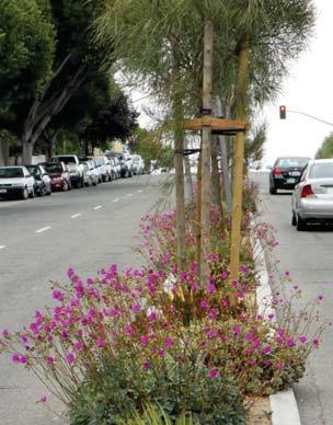
14 Regenerative Landscape Regenerative Landscape Adeline Street, Emeryville Adeline Street, Emeryville Regenerative Landscape Regenerative Landscape Doyle Hollis Park, Emeryville Pollinator Pathway, Seattle


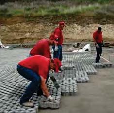
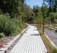
15 Regenerative Landscape Integrated Stormwater Management Pollinator Pathway, Seattle Integrated Stormwater Management Integrated Stormwater Management Dixieanne Ave, Sacramento Dixieanne Ave, Sacramento


16 Dixieanne Ave, Sacramento Integrated Stormwater Management Dixieanne Ave, Sacramento Water Management Dixieanne Ave, Sacramento Dixieanne Ave, Sacramento Material Production & Harvesting Village Homes Streets, Davis Material Production & Harvesting Village Homes Streets, Davis Village Homes Streets, Davis


17 Harvesting Improving Environmental Benefits Through Materials Cermak / Blue Island, Chicago Support Maintenance 6. Building Social Infrastructure Berkeley Rose Garden


18 Support Maintenance Identity Guerrero Street, San Francisco Identity, Urban Form and Sense of Place Portland, Oregon

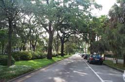


19 Savannah, Georgia Davis, California
Urban Greening Plan Proposed Policies and Programs Matrix Existing City Plans and Goals Programs Policies Notes/Comments
 Urban Greening Plan Circulation Plan for Bicyclists and Pedestrians (2007) 1.1 - Develop a coordinated Trail Maintenance Volunteer Program that identifies funding and leverages community efforts and partnerships
Green Streets. Sustainable Stormwater Solutions for Greener Communities and a Cleaner Bay
 Green Streets Sustainable Stormwater Solutions for Greener Communities and a Cleaner Bay As the Bay Area continues to grow through development of roads, revitalization of neighborhoods, and construction
URBAN GREENING GRANT PROGRAM FOR SUSTAINABLE COMMUNITIES ROUND 2 FUNDING RECOMMENDATIONS
 Agenda Item #6 URBAN GREENING GRANT PROGRAM FOR SUSTAINABLE COMMUNITIES ROUND 2 FUNDING RECOMMENDATIONS BACKGROUND Proposition 84 (the Safe Drinking Water, Water Quality and Supply, Flood Control, River
Coast Highway Oceanside, California
 Coast Highway Oceanside, California Coast Highway Plan Zones What We ve Heard - Walkable/Bikeable Community (Senior and Child Friendly) -Wider Sidewalks -Street Trees -Traffic Calming -Bike Lanes -Paseos
CHAPTER 8. Mrs. Zimman s Class - Central Elementary
 SUSTAINABILITY CHAPTER 8 Mrs. Zimman s Class - Central Elementary 8.1 OVERVIEW Green infrastructure also known as low impact development (LID) and environmental or sustainable site design is an environmentally
CITY OF BOYNTON BEACH SE 1 ST STREET COMPLETE STREETS IMPROVEMENTS
 CITY OF BOYNTON BEACH SE 1 ST STREET COMPLETE STREETS IMPROVEMENTS N Project Location -Town Square -Villages at Ocean SE 1st St, between E Woolbright Rd and SE 2nd Ave Project Location -Boynton One -Publix
Appendix E: Illustrative Green Infrastructure Examples
 Appendix E: Illustrative Green Infrastructure Examples Integrating LID into San Francisco s Urban Landscape Figure E. High-density Residential Figure E. Low-density Residential Figure E. Mixed Use 7 Figure
San Francisco Bay Pilot: Sausal Creek Community Leader Charrette May 11, 2016 Marcus Griswold
 San Francisco Bay Pilot: Sausal Creek Community Leader Charrette May 11, 2016 Marcus Griswold 1 Overview Project Overview Watershed Context Assets and Challenges Opportunities Green Streets Creek Access
Dogpatch/22nd Street Greening
 TEAM MEMBERS Prepared for: GreenTrustSF Central Waterfront www.gtsfcw.org Prepared by: Fletcher Studio San Francisco, CA www.fletcherstudio.com Landscape Architecture Urban Design Environmental Planning
APPENDIX E. El Cerrito Parks and Recreation Facilities Master Plan Recommendations by Factor for Consideration
 APPENDIX E El Cerrito Parks and Recreation Facilities Master Plan s by Factor for Consideration This page is intentionally blank RECOMMENDATIONS BY FACTOR OF CONSIDERATION: BY PARK AND/OR ASSET EL CERRITO
Bethesda Downtown Plan
 Bethesda Downtown Plan Planning Board Update Connecticut Avenue Location Economic Sustainability Social Environmental Scope Coming Soon! Team Listening, Twitter Outreach We Are Here Engagement Challenge
Annual Reporting for FY Regional Supplement for New Development and Redevelopment
 Regional Supplement for New Development and Redevelopment San Francisco Bay Area Municipal Regional Stormwater Permit September 2012 Table of Contents Page INTRODUCTION 2 Low Impact Development 2 C.3.c.iii.(1)
Planning and Design: Applied LID Techniques Redevelopments, Housing, Mixed Use, Infrastructure
 Civil Engineering Landscape Architecture Environmental Restoration Planning Planning and Design: Applied LID Techniques Redevelopments, Housing, Mixed Use, Infrastructure Peg Staeheli, ASLA, LEED AP March
WELCOME WHY A TEMPORARY PATHWAY? WE WANT TO HEAR FROM YOU
 WELCOME In March, the City of Vancouver purchased the lands known as the Arbutus Corridor from Canadian Pacific Railway for the purpose of creating a transportation corridor from False Creek to the Fraser
Discussion Questions - Summary. 1. What do you value most about the area and think needs to be preserved by the Plan?
 Community Meeting #1 Discussion Questions - Summary 1. What do you value most about the area and think needs to be preserved by the Plan? Architectural Retain character through preservation of historical
Getting Started On Your Green Infrastructure (GI) Plan
 Plan") Getting Started On Your Green Infrastructure (GI) Plan Peter Schultze-Allen EOA Inc. Annual SCVURPPP C3 Workshop June 16, 2015 Presentation Outline MRP 2.0 C.3.j (GI) requirements GI Framework elements
Getting Started On Your Green Infrastructure (GI) Plan Peter Schultze-Allen EOA Inc. Annual SCVURPPP C3 Workshop June 16, 2015 Presentation Outline MRP 2.0 C.3.j (GI) requirements GI Framework elements
AREA-WIDE PEDESTRIAN AND BICYCLE CIRCULATION
 OUSD LANEY CHILD CARE CENTER ART BUILDING LANEY COLLEGE BALL FIELDS PCCD OFFICES PERALTA PARK AQUATIC CENTER & ESTUARY PARK EDOFF MEMORIAL BANDSTAND SNOW PARK COURT HOUSE OAKLAND MUSEUM OAK ST AREA-WIDE
Rezoning Issues Setting a Foundation for Zoning Decisions
 Rezoning Issues Setting a Foundation for Zoning Decisions City Council Workshop May 2, 2016 Agenda Goal Need actionable items and sequence of steps Foundation for Zoning Decisions Council Workshop Discussion
Harmony Technology Park Third Filing, Second Replat Custom Blending, Project Development Plan/Final Development Plan - FDP #130021
 ITEM NO FDP #130021 MEETING DATE July 23, 2013 STAFF Pete Wray ADMINISTRATIVE TYPE I HEARING STAFF REPORT PROJECT: APPLICANT: OWNER: Harmony Technology Park Third Filing, Second Replat Custom Blending,
Ken Kortkamp, PE San Francisco Public Utilities Commission San Francisco, CA
 Ken Kortkamp, PE San Francisco Public Utilities Commission San Francisco, CA Development Process of San Francisco s GI Typical Details SCVURPPP GI Workshop April 19, 2017 Outline How to develop GI details
TOWN BRANCH COMMONS & VINE STREET MOBILITY IMPROVEMENTS
 TOWN BRANCH COMMONS & VINE STREET MOBILITY IMPROVEMENTS CONTACT: Jeff Fugate, President O: 859-367-4972 F: 859-425-2292 JFugate@LexingtonDDA.com www.lexingtondda.com TOWN BRANCH COMMONS & VINE STREET MOBILITY
APN#: Lot Size: ±5,625 SF. Vacant corner lot. Current Height Limit: 70 FT. Current Zoning: CB - Central Business District
 900 MacDonald Avenue Richmond, CA 900 MacDonald Avenue Richmond Berkeley Features APN#: 538-260-001-2 Lot Size: ±5,625 SF Vacant corner lot Current Height Limit: 70 FT Current Zoning: CB - Central Business
Monitoring Performance and Effectiveness of Urban Stormwater Best Management Practices. Jim Duncker, USGS Kuldip Kumar, MWRDGC David Leopold, CDOT
 Monitoring Performance and Effectiveness of Urban Stormwater Best Management Practices Jim Duncker, USGS Kuldip Kumar, MWRDGC David Leopold, CDOT Stormwater Management Water Efficiency Transportation Energy
M E M O R A N D U M. DATE: July 19, Patrick D. O Keeffe, City Manager. Economic Development & Housing
 M E M O R A N D U M DATE: July 19, 2011 TO: FROM: Patrick D. O Keeffe, City Manager Economic Development & Housing SUBJECT: Resolution of the City Council of the City of Emeryville Approving the Application
Installed Hardiness Zone 9b
 Installed 2003 Hardiness Zone 9b California State University at Sonoma Student Housing - Peteluma, CA Over 125 standard diameter greenscreen Column Trellis units are mounted to steel posts to create a
Meeting Purpose & Agenda
 Meeting Purpose & Agenda Meeting Purpose: To provide a summary of the results of the Downtown Parks Site Assessment and Feasibility Study By recommendation, provide direction to staff on which City-owned
City of Lafayette Study Session Project Data
 City of Lafayette Study Session Project Data For: Design Review Commission By: Michael P. Cass, Senior Planner Date: August 24, 2015 Property Address: 954 Mountain View Drive APN: 243-070-011 Zoning District:
3575 Ringsby Ct. taxibyzeppelin.com NOW PRE-LEASING
 3575 Ringsby Ct. taxibyzeppelin.com NOW PRE-LEASING BUILDING Flight, the ninth phase to the TAXI campus, borrows best practices in design and programming from its predecessors, expanding the options for
City of Hermosa Beach Administrative Policy #
 City of Hermosa Beach Administrative Policy # SUBJECT: Living Streets Policy Date: Approved by: City Council Authority: Public Works Department & Community Development Department Mayor, PURPOSE The City
Transportation Land Use Integration & Regional Planning. Don Kostelec, AICP Senior Planner, Louis Berger Group February 1, 2010
 Transportation Land Use Integration & Regional Planning Don Kostelec, AICP Senior Planner, Louis Berger Group February 1, 2010 Transportation Land Use Integration DOT-HUD-EPA Sustainable Communities Initiative
Postcards from America Required landscape Exercise LANDSCAPE FEATURE TOPICS
 Postcards from America Required landscape Exercise LANDSCAPE FEATURE TOPICS Choose a mix of 16 landscapes from the 80 listed to include in your portfolio. The 16 landscape features you choose should be
Berkeley Strategic Transportation Plan
 Berkeley Strategic Transportation Plan 48 4. Priming the Pipeline 4. Priming the Project Pipeline Building on our history Using past studies that required the effort and input of all of Berkeley s distinct
Rebuilding Landscapes. Permit Ready Garden Design Templates
 Rebuilding Landscapes Permit Ready Garden Design Templates Project Goals Streamline permitting Save homeowner cost Water saving designs Fire Safer guidelines Attractive, engaging front yard plans Integrate
SCVURPPP Green Infrastructure Handbook. Kristin Kerr, P.E. EOA, Inc. April 19, 2017
 SCVURPPP Green Infrastructure Handbook Kristin Kerr, P.E. EOA, Inc. April 19, 2017 Outline of Presentation Overview Handbook Contents Schedule Overview MRP requires GI Plans to include general guidelines,
Holloway Green Street
 Holloway Green Street SSIP Phase 1: Green Infrastructure Projects Presentation for the CAC Bicycle Subcommittee Thursday, August 22, 2013 Saed Toloui SSIP Green Infrastructure Project Manager 1 Sewer System
Green Streets and Porous Pavement: Lessons for Sustainability, Success and Savings
 Green Streets and Porous Pavement: Lessons for Sustainability, Success and Savings Freeman Anthony P.E. Project Engineer City of Bellingham, WA 2013 APWA Congress Chicago, IL 25 August 2013 Presentation
Potential Green Infrastructure Strategies May 6, 2015 Workshop
 Potential Green Infrastructure Strategies May 6, 2015 Workshop Background The City of Cortland is developing the Tioughnioga Urban Headwaters Green Infrastructure Action Plan with funding from the National
Figure 1 SSIP Watersheds (Source: SFPUC) North Shore Watershed
 North Shore Watershed") LOVE AND HAIGHT - GREENING THE STREETS OF SAN FRANCISCO Thomas M. Sweet, PE, LEED AP BD+C Senior Engineer, AECOM, San Francisco Amir Ehsaei, PhD Project Engineer, AECOM, San Francisco Purpose: Case study
LOVE AND HAIGHT - GREENING THE STREETS OF SAN FRANCISCO Thomas M. Sweet, PE, LEED AP BD+C Senior Engineer, AECOM, San Francisco Amir Ehsaei, PhD Project Engineer, AECOM, San Francisco Purpose: Case study
Albany 2035 General Plan Draft Goals, Policies, and Actions
 ATTACHMENT A Albany 2035 General Plan Draft Goals, Policies, and Actions July 1, 2015 About this Document: This document contains the Revised Draft Goals, Policies, and Actions for the Albany 2035 General
DRAFT ROOSEVELT ROAD. District Recommendations. Figure 5.23 The Roosevelt Road Corridor
 CHAPTER 5 Figure 5.23 The Road Corridor Road will develop as a mixed-use corridor, emphasizing regional retail, west of the river and mixed-use development east of the river. KEY RECOMMENDATIONS 1. High
7-PARKS, OPEN SPACE & PUBLIC ART
 7-s, Open Space & Public Art 7-PARKS, OPEN SPACE & PUBLIC ART This chapter provides recommendations for the expansion of new parks, plazas and open space that serve the many user groups targeted for downtown.
Landscape and Streetscape Design 2.5
 Landscape and Streetscape Design 2.5 2.5.1 Goals 2.5.2 Planting 2.5.3 Sidewalks and Pavement 2.5.4 Furnishings 2.5.5 Walls 2.5.6 Lighting 2.5.7 Stormwater 2.5.8 Street Cross Sections 2.5 LANDSCAPE AND
green streets San Antonio, Texas February 17-18, 2009 Chris Kloss
 green streets San Antonio, Texas February 17-18, 2009 Chris Kloss www.lowimpactdevelopment.org typical pollutants Examples of Stormwater Pollutants Typical of Roads. 1,2 Pollutant Source Effects Trash
Skinny Streets and Green Neighborhoods: Design for Environment and Community By Cynthia Girling and Ronald Kellett INDEX
 Skinny Streets and Green Neighborhoods: Design for Environment and Community By Cynthia Girling and Ronald Kellett INDEX Note: Page numbers in italics indicate illustrations or tables Alleys, 22, 79, 82
include playgrounds, sports fields, community gardens and picnic areas.
 DEVELOPMENT PLAN OPEN SPACE SYSTEM OPEN SPACE SYSTEM The neighborhood provides for a range of open space types. The Village Square is an important open space in the neighborhood. It serves as a gathering
STEVEN T. MATTAS. Representative Experience
 STEVEN T. MATTAS Steven Mattas is the City Attorney for the City of Walnut Creek and Town of Los Altos Hills, and Assistant City Attorney for the City of South San Francisco. He also serves as General
Des Plaines River Watershed: Opportunity Areas North Community Cluster 1:80,000. Miles. Public Parks or Preserve. Wetland Area
 Service Layer Credits: Harris Corp, Earthstar Geographics LLC Earthstar Geographics SIO 2015 Microsoft Corporation Des Plaines River Watershed: Opportunity Areas North Community Cluster SFR: Single Family
UNIVERSITY OF CALIFORNIA, SAN DIEGO
 UNIVERSITY OF CALIFORNIA, SAN DIEGO BERKELEY DAVIS IRVINE LOS ANGELES MERCED RIVERSIDE SAN DIEGO SAN FRANCISCO SANTA BARBARA SANTA CRUZ CAMPUS PLANNING 9500 GILMAN DRIVE # 0074 TEL: (858) 534 6515 LA JOLLA,
Horizon 2035 Land Use and Transportation Element
 CITY OF SUNNYVALE Horizon 2035 Land Use and Transportation Element City Council Study Session March 7, 2017 Overview General Plan Context Mixed Use Villages Transportation Mode & Parking General Plan Policy
URBAN DESIGN + PLANNING BRIDGING COMMUNITIES
 URBAN DESIGN + PLANNING BRIDGING COMMUNITIES East Pleasanton, Pleasanton, CA CARDUCCI ASSOCIATES PROFILE Founded in 1976, Carducci Associates is a professional landscape architecture and planning firm
March 14, Will Allen Director of Strategic Conservation Planning
 New Frontiers in Land Conservation: Green Infrastructure for Urban Vacant and Underutilized Lands 23 rd Annual RMLUI Conference March 14, 2014 Will Allen Director of Strategic Conservation Planning Special
SFE Policy Committee Presentation. Rachel Kraai
 SFE Policy Committee Presentation Rachel Kraai February 9, 2015 Today s Agenda Green Infrastructure Overview Biodiversity via SSIP Capital Projects Triple Bottom Line (TBL) Framework and Analysis TBL Criteria
UNIVERSITY OF TEXAS BRACKENRIDGE TRACT THE TEAM
 UNIVERSITY OF TEXAS BRACKENRIDGE TRACT THE TEAM 1 JOHNSON FAIN / OLIN PARTNERSHIP Master Planning + Land Use Planning + Urban Design + Landscape Architecture TANIGUCHI ARCHITECTS Design Consultant + Public
INTRODUCTION TO THE ADAPTING TO RISING TIDES EXISTING CONDITIONS AND STRESSORS REPORT
 INTRODUCTION TO THE ADAPTING TO RISING TIDES EXISTING CONDITIONS AND STRESSORS REPORT The Adapting to Rising Tides (ART) project evaluated the current condition of shoreline and community assets, and the
1 Introduction. 4 Environmental Integrity. 7 Community Facilities
 2037: A CALL TO ACTION 2017 COMPREHENSIVE PLAN EXECUTIVE SUMMARY is the purpose of the Q: What Comprehensive Plan? The comprehensive plan serves as a guide for the community s physical, social, and economic
Glenborough at Easton Land Use Master Plan
 Vision Statement Sunrise Blvd. Hazel Ave. Prairie City Rd. Gencorp Property Lincoln Regional Airport 1.0 VISION STATEMENT The identifies City of the principles, goals, policies, and standards Lincoln that
New York City, 19 th c.
 New York City, 19 th c. Lower Manhattan, circa 1930s Westside Highway, Manhattan, circa 1940s Greenpoint Terminal Market, Brooklyn TRANSFORMATIONS ON THE WATERFRONT Harlem River Park, Manhattan BEFORE
Street Interchange, less than one half mile north of the site. In this report the freeway will be referenced as Interstate 80 or I 80.
 The horse barn area of the Golden Gate Fields complex lies opposite the site, adjacent to Gilman Street. Access to the horse barns is controlled at a driveway and gate house on the north side of Gilman
Preliminary Recommendations Tk Takoma/Langley Crossroads Sector Plan
 Preliminary Recommendations Tk Takoma/Langley Crossroads Sector Plan Vision is to achieve a Transit Oriented, pedestrian friendly Community that Celebrates and builds upon the cultural Diversity of the
Page
 Page 36 38 40 4 44 46 Promote Downtown Intensify Neighborhoods Connect the Anchors Grow the Garden City Enhance Parks and Open Spaces Promote Sustainability 3. DOWNTOWN INITIATIVES Establish a Guiding
Food Scrap Composting Challenges and Solutions in Illinois
 Illinois Food Scrap Coalition September 16, 2014 Funded through a grant from the Illinois Department of Commerce and Economic Opportunity Food Scrap Composting Challenges and Solutions in Illinois Thank
Proposed Major Institution Master Plan Street Vacation. March 19, 2009
 Presentation to Seattle Design Commission Proposed Major Institution Master Plan Street Vacation March 19, 2009 1 Why We Need to Grow More children surviving with chronic disease increasing the demand
The Vision. Photo provided by The Minervini Group. 46 Vision, Objectives & Strategies
 Vision, Objectives & Strategies The is the public framework and guide for future development of the Grand Traverse Commons. The establishes public polices for infrastructure, the preservation of natural
Costal Sustainability and Green Streets, Mobile, Alabama
 Costal Sustainability and Green Streets, Mobile, Alabama A Green Infrastructure Plan for Mobile, Alabama Charlene LeBleu, AICP, ASLA Auburn University Landscape Architecture School of Architecture College
QUESTION 8: What are your Public Realm priorities for implementation? What would you like to see happen first? TELL US WHAT YOU THINK
 Public Realm Plan How will the Public Realm Plan be implemented? The Public Realm Plan document will set out a vision for the next 30 years. Over time, Plan elements and aspects can be implemented as opportunities
Green Streets and Green Infrastructure Planning A Tale of Two Cities: San Mateo and Emeryville
 Green Streets and Green Infrastructure Planning A Tale of Two Cities: San Mateo and Emeryville SCVURPPP Annual C3 Workshop June 4, 2014 Peter Schultze-Allen, EOA Presentation Overview Goals/Incentives
Surrey Ecosystem Management Study
 Surrey Ecosystem Management Study Green Infrastructure Network Opportunities Public Open House & Information Session June 24 th, 2010 EMS Process Ecological Inventory Ecological Assessment Management Policy
EarthShare California
 EarthShare California Contact person: Tania Katbi, Director of Development Phone Number: (714) 386-0806 Email: tania@earthshareca.org Website: www.earthshareca.org How can you choose between drinking clean
RESIDENTIAL + MIXED USE CONNECTING PEOPLE
 RESIDENTIAL + MIXED USE CONNECTING PEOPLE 2900 On First, Seattle, WA CARDUCCI ASSOCIATES PROFILE Founded in 1976, Carducci Associates is a professional landscape architecture and planning firm based in
FACT SHEET: Pervious Pavement with Infiltration
 FACT SHEET: Pervious Pavement with Infiltration DESCRIPTION Pervious pavement is a Green Infrastructure (GI) technique that combines stormwater infiltration, storage, and structural pavement consisting
The Role of Cities in Planning Transportation Megaprojects
 The Role of Cities in Planning Transportation Megaprojects SPUR Oakland, November 28, 2018 + Elizabeth Deakin / UC Berkeley + Eric Eidlin / City of San Jose + Doug Johnson / City of San Francisco The Role
PROJECT DESCRIPTION. Providing a mix of housing options supporting a diversity of needs (800-1,600 sf 1-3 bd flats and Townhomes).
.") ROHNERT PARK Planned Development - Preliminary Application Project Site LOCATION MAP Project Site Rohnert Crossings is a acre mixed-use urban village proposed in the center of the city adjacent what will
ROHNERT PARK Planned Development - Preliminary Application Project Site LOCATION MAP Project Site Rohnert Crossings is a acre mixed-use urban village proposed in the center of the city adjacent what will
4. Parks, Open Space and Urban Forest
 4. Parks, Open Space and Urban Forest Goals 1. Enhance parks as public gathering places for the neighbourhood 2. Refresh park facilities to attract diverse ages and activities 3. Improve waterfront access
Midtown Greenway to lake street
 Making the connection: Midtown Greenway to lake street May 2016 Design experiment: site amenities, wayfinding, and activities at Cepro, near the Midtown Global Market Recent Greenway Development Highlights
Solana Ranch Elementary School
 2015 Exhibition of School Planning and Architecture Solana Ranch Elementary School Category: New Construction Solana Beach School District Solana Beach, CA Project name Project name Landscape Plan Community
Chapter 6. Overall Vision RECOMMENDATIONS. More Trail and Trail. Connections. Equal Access to Park. Facilities and Programs. Water Access.
 Overall Vision More Trail and Trail Connections Equal Access to Park Facilities and Programs Water Access Environment Variety Chapter 6 RECOMMENDATIONS Chapter 6 The following recommendations for park,
Key Moves in the Plan
 Key Moves in the Plan 2 Add housing that fits the neighbourhood s character Make it easier to leave the car behind Oak Bay Avenue Village plan to be completed in future planning process Future active transportation
4.1 AESTHETICS AND VISUAL QUALITY
 SCOPE AND METHODOLOGY 4.1 AESTHETICS AND VISUAL QUALITY This section evaluates the potential impacts to aesthetics and visual quality. Aesthetics refers to visual resources and the quality of what can
3. Are there any projects exempt from the definition of Regulated Projects?
 STORMWATER REQUIREMENTS: OVERVIEW OF PROVISION C.3 Background: On October 14, 2009, the Regional Water Quality Control Board, San Francisco Bay Region, issued a municipal regional stormwater permit (MRP)
consider rainwater harvesting and reuse DESIGN APPROACHES
 consider rainwater harvesting and reuse DESIGN APPROACHES rainwater AS A SUSTAINABLE RESOURCE D RAINWATER HARVESTING The on-site collection, treatment and storage of rainwater typically using rooftop catchment
Property Value + Business Impacts
 Property Value + Business Impacts Dr. Kelly Clifton at Portland State University is currently working on a study that looks at if/how cycling customers and cycling infrastructure affect the business bottom
Whittier Greenway Trail. Est. 2009
 Whittier Greenway Trail Est. 2009 The Whittier Greenway Trail begins in the northwest corner of Whittier, near the 605 Freeway, and closely parallels Whittier Boulevard. When it reaches Painter Avenue,
LAKE COUNTY REGIONAL TRAIL PROJECTS
 LAKE COUNTY REGIONAL TRAIL PROJECTS LAKE APOPKA LOOP TRAIL SOUTH LAKE TRAIL LEESBURG-WILDWOOD TRAIL LAKE-CROSS FLORIDA GREENWAY LAKE LOUISA-HORIZON WEST WEKIVA PARKWAY- SR 46 CORRIDOR SR 40 CORRIDOR VAN
San Francisco Parks Alliance. #WeMakeParksHappen
 San Francisco Parks Alliance #WeMakeParksHappen SFPA - over the years Created Park Partner Program Rebuilt the Conservatory of Flowers Passed Proposition B Mobilized the Blue Greenway Invested over $100
a great new program that helps make the best use of something we re all familiar with - rainwater. Building a Better Long Beach
 Management practices best Introducing LID a great new program that helps make the best use of something we re all familiar with - rainwater. Long Beach Development Services Building a Better Long Beach
ROAD PAVING VARIOUS LOCATIONS LANE KM
 ROAD PAVING VARIOUS LOCATIONS 9.317 LANE KM $1,465,200 General: $1,465,200 BASED ON CONDITION ASSESSMENTS OF THE ENTIRE ROAD NETWORK; USING ASSET MANAGEMENT PRINCIPLES, ROADS THAT ARE SUITABLE FOR REPAVING
Islais Creek, Sunnydale and Yosemite Watersheds. Community Workshop Summary Report Urban Watershed Planning Game Results
 UWA REPORT SEWER SYSTEM IMPROVEMENT PROGRAM Grey. Green. Clean. Islais Creek, Sunnydale and Yosemite Watersheds November 16, 2013 Urban Watershed Assessment Community Workshop Summary Report Urban Watershed
BROOKE PETERSON, AICP Associate Principal
 BROOKE PETERSON, AICP Brooke s career includes a wide range of long-range policy planning, development project planning, urban design, and environmental planning experience for both the public and private
HILLSDALE STATION AREA PLAN COMMUNITY WORKSHOP 2 City of San Mateo
 HILLSDALE STATION AREA PLAN COMMUNITY WORKSHOP 2 City of San Mateo June 30, 2010 AGENDA Welcome and Introductions Workshop 1 Summary Presentation of Alternatives Small Group Discussion of Alternatives
COLLABORATION BETWEEN CITY, COUNTY, UNIVERSITY AND PROPERTY OWNERS
 COLLABORATION BETWEEN CITY, COUNTY, UNIVERSITY AND PROPERTY OWNERS 2 City-Making Urban Design 3 OFFICES Atlanta Boston Charlotte Chicago Dallas Dubai Dundas Houston London Los Angeles Miami Minneapolis
Main Street Conversion Site
 Main Street Conversion Site Borough of Brooklyn, New York Preliminary Presentation Park Expansion Design & Development Committee 13 September 2012 Michael Van Valkenburgh Associates, Inc. Landscape Architects,
REDLANDS TRANSIT VILLAGES SPECIFIC PLAN
 REDLANDS TRANSIT VILLAGES SPECIFIC PLAN CITY COUNCIL STUDY SESSION JANUARY 4, 2019 Redlands Blvd. Eureka St. Orange St. State St. Citrus Ave. Vine St. GENERAL PLAN TRANSIT VILLAGES WE ARE HERE SPECIFIC
Urban Sustainability Area Designation
 Urban Sustainability Area Designation City of Santa Cruz October 2013 The City of Santa Cruz Urban Sustainability Area (USA) encompasses the City s business centers and primary transportation corridors
COMPLETE GREEN STREET CHECKLIST
 COMPLETE GREEN STREET CHECKLIST This document was developed to dissect the structure of an urban street and explore opportunities to make our streets more complete while also integrating green street strategies.
Project Output Indicators for Federal Gas Tax Investments
 Municipalities are required to report results achieved through the investment of federal Gas Tax funds under the Municipal Funding Agreement. AMO uses the indicators listed below to capture the outputs
PROP. 84 REMOVING BARRIERS TO LID: MUNICIPAL CODE UPDATE ASSISTANCE CASE STUDY: CODE UPDATES IN ARCATA
 PROP. 84 REMOVING BARRIERS TO LID: MUNICIPAL CODE UPDATE ASSISTANCE CASE STUDY: CODE UPDATES IN ARCATA OCTOBER 7, 2015 CASE STUDY: CODE UPDATES IN ARCATA Arcata is a city located in Humboldt County immediately
Conservatory Green, Stapleton s 8th great neighborhood.
 Conservatory Green, Stapleton s 8th great neighborhood. Rocky Mountain Arsenal National Wildlife Refuge Quebec St. Forward. LOOKING Dick s Sporting Goods Park School Stapleton s success over the years
Walnut Creek BART Station
 Walnut Creek BART Station Mixed Use Transit Oriented Project Design Review Commission Study Session May 17, 2006 Applicant: Walnut Creek Transit Lifestyles Associates Joint Venture: Transit Village Associates
SFMTA PHELAN LOOP AND PUBLIC PLAZA PHELAN OCEAN AVENUE
 SFMTA Municipal Transportation Agency Image: a bus in front of the Palace of the Legion of honor SFMTA PHELAN LOOP AND PUBLIC PLAZA PHELAN AVENUE @ OCEAN AVENUE Community Meeting May 23, 2012 San Francisco,
Inventory of the Robert L. Thayer Papers on Landscape Architecture D No online items
 http://oac.cdlib.org/findaid/ark:/13030/c81j9gz3 No online items Liz Phillips University of California, Davis. Library, Dept. of Special Collections 2018 1st Floor, Shields Library, University of California