NORTHERN URBAN SERVICE AREA AMENDMENT APPLICATION VILLAGE OF DEFOREST
|
|
|
- Kimberly Robbins
- 5 years ago
- Views:
Transcription
1
2 NORTHERN URBAN SERVICE AREA AMENDMENT APPLICATION VILLAGE OF DEFOREST This information supports the Village of DeForest s application to amend the Northern Urban Service Area to include several parcels plus public rights-of-way totaling acres. These include parcels , , , , , and The parcels, referred to as the Yahara Gateway Land, are currently addressed at 4542 and 4684 State Highway 19, west of Interstate and east of the Westport town line. Submitted: April 10, 2017 Prepared by: MDRoffers Consulting and Vierbicher Associates With support from the Village of DeForest staff NUSA AMENDMENT APPLICATION, Page 1
3 Table of Contents 1 Introduction... 3 Map 1: Yahara Gateway Land, Village of DeForest Proposed Urban Service Area Amendment Plan Consistency and Need... 5 Map 2: Recommended Scenario, North Yahara FUDA Study... 8 Map 3: Future Land Use, Village of DeForest Comprehensive Plan... 9 Map 4: Future Transportation and Community Facilities, Village of DeForest Comprehensive Plan (also Village s Official Map) Intergovernmental Cooperation Land Use Figure 1: Northern Urban Service Expansion Area, Yahara Gateway Land, Village of DeForest Map 5: Neighborhood Plan Map, Preferred Alternative Economic and Housing Development Natural, Cultural, and Agricultural Resources Utilities Sanitary Sewer Service Figure 2: MMSD Waunakee-DeForest Interceptor Figure 3: Northeast Interceptor DeForest Extension Capacity Evaluation Figure 4: Current Flows to MMSD s Interceptor Utilities Municipal Water Service Map 6: Overall Utility System Configuration Stormwater Management Transportation Community Facilities and Services Appendices NUSA AMENDMENT APPLICATION, Page 2
4 1 Introduction Map 1 indicates the proposed Northern Urban Service Area (NUSA) expansion area, including existing public rights-of-way. For purposes of this application, the proposed NUSA expansion area is referred to as the Yahara Gateway Land or the Land. The Yahara Gateway Land encompasses acres northwest of the interchange of Interstate and State Highway 19, including acres of private real estate and 25.5 acres of existing highway rights-of-way. The private real estate is within three separate ownerships: Yahara Hills LLC, Windsor Gateway LLC, and the Ballweg Family Limited Partnership. The Yahara Gateway Land is ready for inclusion in the NUSA. The Land joins the existing NUSA boundary on its east and south sides. Development of the Land will provide an opportunity for the Village of DeForest to accomplish multiple goals, including the following: Develop a highway-oriented retail and commercial service district serving local and regional customers along the Interstate and Highway 19, but also integrated into a mixed use setting. Provide a setting for denser living options and institutional uses geared particularly to the Baby Boomer and Millennial populations. Interconnect Village s north and south (former Token Creek) water utility systems, which currently operate as separate systems. Manage stormwater and promote infiltration in accordance with the Village s stormwater management ordinances, which is one of the most progressive in the County including a 100% stay-on standard. Advance Yahara River corridor protection and related recreational opportunities and access, in accordance with local and County plans. Implement and dovetail with multiple plans for this area, including the North Yahara Future Urban Development Area (FUDA) Study, Village of DeForest Comprehensive Plan, DeForest-Windsor Cooperative Plan, and Wisconsin Department of Transportation (WisDOT) plans for the expansion of Highway 19 adjacent to the Land. NUSA AMENDMENT APPLICATION, Page 3
5
. The Village s Comprehensive Plan is available online at www.vi.deforest.wi.us on the Planning, Zoning, and Development page.")


6 2 Plan Consistency and Need The Village s Planning and Zoning Commission determined that the immediate addition of the Yahara Gateway Land to the NUSA is consistent with DeForest s Comprehensive Plan (see Commission resolution in Appendices). The Village s Comprehensive Plan is available online at on the Planning, Zoning, and Development page. The proposed addition of the Yahara Gateway Land to the NUSA is also consistent with the 2012 North Yahara FUDA Study, the DeForest-Windsor Cooperative Plan, the Village of Windsor Comprehensive Plan, and other plans affecting the Land. The proposed addition of the Yahara Gateway Land to the NUSA advances the recommended scenario within the North Yahara FUDA Study. As reflected on Map 2, the Yahara Gateway Land is shown as being within the Future Urban Development Area (FUDA). It is designated for a combination of mixed use and commercial land use. The FUDA effort was completed jointly with DeForest, Windsor, and Vienna and with interaction with adjacent Westport and the North Mendota FUDA Study. This designation of the Yahara Gateway Land within the FUDA is echoed in the DeForest Comprehensive Plan (Map 3). The Village of DeForest, through its Comprehensive Plan, also identifies this area for future commercial and mixed use development. Within the commercial future land use designation, the Village advocates: High-quality indoor retail, commercial service, office, health care, and institutional buildings. Developments providing access to and an attractive rear yard appearance for existing and future land uses behind these sites. Addressing off-site traffic, environmental, and neighborhood impacts as part of new development proposals. Within the mixed use future land use designation, the Village advocates: A blend of commercial services, retail, office, multiple family residential, and/or institutional land uses, including mixed use sites and/or buildings, creating vibrant urban places and community gathering spots. Non-residential uses comprising a minimum of 50% of the land area within each mixed use area. This image, a crop of the DeForest Comprehensive Plan Future Land Use Map, shows the Yahara Gateway Land in the context of existing and planned development on surrounding lands. The blue dotted line is the extent of the North Yahara Future Urban Development Area. The pink shaded areas indicate the commercial future land use designation, the purple shaded areas indicate the mixed use future land use designation, and the green areas represent preliminary environmental corridor areas. NUSA AMENDMENT APPLICATION, Page 5
7 Integrating multiple family residential components in mixed use areas with the fabric of the surrounding neighborhood through design, pedestrian connections, landscaping, and scale. Inclusion of the Yahara Gateway Land in the NUSA is also consistent with the growth phasing policy within the DeForest Comprehensive Plan. That policy indicates that the Village will utilize the following factors in making decisions on the timing of new development, including whether and when to request urban service area expansions. The Village s phasing policy points are in italics below, with commentary related to this application in normal type. 1. The desire to promote an orderly, sequential pattern of land use and community development in order to ensure that the provision of public services, roads, and utilities keep pace with development. Both DeForest and Windsor have long identified the land for future commercial and mixed use development. The Land is bounded on two sides by existing urban development, is at a freeway interchange, and the Village has sanitary sewer and water service along Highway 19 to the immediate south. As described later in this application, inclusion of the Land in the NUSA will also facilitate the long-intended interconnection of DeForest s north and south water systems. 2. The projected impact on other Village goals of preserving agriculture or the natural environment in the same general area, if applicable. Proposed development of the Land will meet the Village s strict stormwater ordinance and CARPC criteria for environmental corridor mapping. The Village also desires to thoughtfully transition and provide appropriate linkages to the Cherokee Marsh Wildlife Area to the southwest. The planned land uses for the Land are consistent with all County and local comprehensive and farmland preservation plans. In 2015, DeForest adopted a State-certified farmland preservation zoning district, which is mapped over most of its extraterritorial zoning area within the Town of Vienna. 3. The projected impact on Village desires to redevelop or infill other parts of the Village. The Land will facilitate larger scale and highway oriented commercial service, retail, hospitality, multiple family, and institutional uses that are not present and not viable on smaller redevelopment and infill sites. The Land is also 3+ miles south of the Village s downtown and Main Street area the Village s primary redevelopment and infill areas identified in the Comprehensive Plan. This removes correlation between (re)development opportunities in these disparate parts of the Village. 4. Whether the proposed development provides a unique asset or special amenity desired by the Village, as specified in Village plans or as otherwise indicated by the Village Board. Through its Comprehensive Plan and marketing efforts, the Village has identified the expansion of local retail, restaurant, hotel, and office facilities as central to its economic interests and quality of life. The Village desires more locations to shop locally, which the planned development of the Land will provide. The Village anticipates that the first development on the Land will include a major regional retailer. While there is other undeveloped land in DeForest, there are no available 20+ acre parcels to accommodate the needs of this or a similar or complementary user. 5. The availability of public infrastructure such as road capacity, utility availability or capacity, and pedestrian and other public facilities to serve the proposed development. At time of writing, WisDOT was re-decking the interchange and reconstructing and realigning ramps at the Interstate/Highway 19 interchange. Further, WisDOT will NUSA AMENDMENT APPLICATION, Page 6
8 reconstruct Highway 19 between the Interstate and River Road in 2020, providing a four-lane roadway adjacent to the Land. The Village is conducting a traffic impact analysis to determine appropriate improvements at the two planned road intersections with Highway 19. Map 5 delineates those intersections, plus an internal road network that becomes more conceptual heading north into the Land. Bike, pedestrian, and transit connections from the Land to areas beyond are more challenging, which is influencing the proposed land use pattern. Still, the Village plans for a future multiuse path along Highway 19 (WisDOT s Yahara River bridge reconstruction will include the necessary width) and some connection to the north crossing the Interstate at River Road/Windsor Road to link with the Village s existing path network. Also, the Village s Comprehensive Plan and regional plans suggest an express bus route to DeForest that may utilize the adjacent Interstate corridor (see Map 4). Internally, sidewalks and park/recreation facilities are required in new developments by DeForest subdivision ordinance. The Cherokee Marsh Wildlife Area and existing public utilities are directly adjacent. 6. If such public infrastructure is unavailable, the projected timing of and funding for public infrastructure improvements to serve the proposed development. Adjacent public infrastructure is currently available. Further, the proposed addition of the Land to the NUSA will facilitate the interconnection of the Village s north and south water systems an improvement which has significant benefits beyond the NUSA expansion area. 7. The ability of the Village to cost-effectively provide community services to the proposed development or area, and the advice of other units of government such as the DeForest Area School District (DASD) to provide services under their control. The Village already provides services along the Highway 19 corridor adjacent to and east of the Yahara Gateway Land. Enrollment impacts on the school district are likely to be manageable. Planned dwelling units are multiple family units, which generate fewer students per housing unit than a typical new single family housing development. The consultant projects a maximum of 50 students at build-out. The Land is within the DASD s Windsor Elementary School attendance area. The DASD will open an expanded and remodeled Windsor Elementary School in fall 2017 to serve this and other areas. STEAM additions to the middle and high schools have also recently been completed. 8. Whether the proposed development area has been or will be annexed or attached to the Village, where annexation or attachment is specified by adopted intergovernmental agreements/cooperative plans or otherwise anticipated prior to development. Parcels and (Windsor Gateway LLC) were attached to the Village of DeForest in January 2017, per the DeForest-Windsor Cooperative Plan. The rest of the real estate with the NUSA expansion area will also be attached to DeForest, per a locally-approved amendment to the Cooperative Plan. 9. The degree of compatibility with other aspects of adopted intergovernmental agreements/cooperative plans to which the Village is a party. Compatible. See Section 3 of this application for more information. 10. For proposed urban (publicly sewered) development, whether the proposed development area is within the Urban Service Area and MMSD boundary, or the Village reasonably expects the development area to be added to the Urban Service Area and MMSD boundary in the near term. The Yahara Gateway Land is already in the regional and local FUDA and the MMSD service area. NUSA AMENDMENT APPLICATION, Page 7

9 Map 2: Recommended Scenario, North Yahara FUDA Study NUSA AMENDMENT APPLICATION, Page 8

10 Map 3: Future Land Use, Village of DeForest Comprehensive Plan NUSA AMENDMENT APPLICATION, Page 9
 NUSA AMENDMENT APPLICATION, 4.10.")
11 Map 4: Future Transportation and Community Facilities, Village of DeForest Comprehensive Plan (also Village s Official Map) NUSA AMENDMENT APPLICATION, Page 10
12 3 Intergovernmental Cooperation The Village has made special effort to unify its Comprehensive Plan and future development and preservation plans with those of adjacent communities, Dane County, and the region. The Village regularly engages with adjacent and overlapping communities on its planning efforts. The Land is at the eastern edge of the much larger River Road/Highway 19 Study Area as shown on Map 3. Building upon advice in the North Yahara and North Mendota FUDA Studies, recommendations for this study area from the Village s Comprehensive Plan are as follows: In conjunction with affected property owners and adjacent local governments, the Village intends to complete a neighborhood development plan for its planned development area between River Road, Highway 19 and the Interstate. That effort should consider compatible land use transitions, progressive stormwater management, preservation and enhancement of the Yahara River corridor, and transportation access. The Village also intends to work towards an intergovernmental agreement with Westport (and possibly others) to include issues and areas of mutual concern for lands west of River Road, including community separation. In general, the Village will work collaboratively to protect sensitive environmental resources in this study area, which connects with Cherokee Marsh. Such an effort will consider organism movement, habitat preservation, minimizing high traffic or disturbance near the environmental corridor, and invasive species removal and management in the corridor. Through its Comprehensive Plan the Village of DeForest has also identified pursuit of a boundary agreement with the Town of Westport as a high priority initiative. Westport s eastern boundary lies just west of the Yahara Gateway Land. Based on these recommendations, the Village of DeForest and Town of Westport began in Winter 2017 discussing an intergovernmental boundary agreement. The Village anticipates that agreement to reinforce the community separation and farmland and natural area preservation west of the Yahara Gateway Land that is already embodied in local, County, and regional plans. The Village administration hopes to complete this agreement in The Village has made Westport officials aware of this proposed urban service area application, and understands that Westport has no objection to the application. Westport may be concerned that possible future road extensions represented on Map 5 may eventually connect to River Road, but that is not the Village s intent. South and west of the Yahara Gateway Land, and north of Highway 19, are 35.7 acres owned by Dane County. This is the northern edge of the Cherokee Marsh County Wildlife Area, which provides for public recreation uses along the adjacent sections of the Yahara River. The area immediately north of these 35.7 acres, which is part of the Yahara Gateway Land, is within the Cherokee Marsh Natural Resource Area Boundary, as designated in the County Parks and Open Space Plan. The Village has begun engagement with Dane County Parks Division staff on collaboration opportunities associated with this proposed NUSA expansion, preservation and sensitive development of land adjacent to the already-acquired Cherokee Marsh Wildlife Area, and possible transportation interconnections. NUSA AMENDMENT APPLICATION, Page 11
13 In March 2017, the Village of DeForest and the Village of Windsor adopted the first amendment to the 2010 DeForest-Windsor Cooperative Plan. At time of writing, that amendment was pending State Department of Administration approval. This amendment reflects Windsor s incorporation as a village, simplifies agreement terms, and accelerates the transfer of certain identified lands from Windsor to DeForest. Among those are the Yahara Gateway Land and all other Windsor territory west of the Interstate. See the letter of support from Windsor included as an appendix for further information. 4 Land Use Most of the developable acreage of Yahara Gateway Land is currently in agricultural use. The two recent farm residences on the Yahara Gateway Land have been recently been, or are in the process of being, torn down. The Land slopes upward from Highway 19 towards the northeast corner, where a high point of 936 feet offers a vantage point over the Interstate. There is 1.1 acre of 12+% slopes near that high point, but no 12+% slopes in any other part of the Land. Areas close to the Yahara River are in combinations of floodplain and wetland. In collaboration with the three property owners, the Village has commissioned a wetland screening and determination on the Land, to be completed this spring. The Village of DeForest and the property owners/developers have collaborated on a neighborhood plan map for the Yahara Gateway Land (Map 5). This Yahara Gateway Neighborhood Plan is consistent with and builds from the Village s Comprehensive Plan. Map 5 shows the preferred alternative for planned land uses and roads for the Land, and also existing and planned uses for surrounding lands. The Neighborhood Plan is intended to guide future development of the Land and fulfill the goals of this NUSA application listed in Section 1. It suggests a predominately commercial development pattern extending north from Highway 19 ( Highway Business District ). Further from Highway 19 and closer to the Yahara River, the plan suggests a Transitional District and then close to the River an area that may be most appropriate for multiple family housing, senior housing, and/or institutional uses ( Yahara District ). The sizes, shapes, and locations of these three districts will vary depending on the actual future demand for different land uses on the Land. All lands will need to be rezoned and subdivided to enable development according to this Neighborhood Plan. The Neighborhood Plan also suggests environmental, stormwater management, and recreational features. Conceptual stormwater management basins are indicated in appropriate general locations, each envisioned to serve either a large development site or multiple smaller sites. Actual locations and configurations of stormwater basins will likely vary. Beyond the basins, the proposed environmental corridor network is entirely focused along the Yahara River corridor. This network will complement the County Wildlife Area and reflect the Village s conservation commitment along the Upper Yahara River corridor within the developed parts of the Village. The proposed corridor network meets all CARPC standards. The environmental corridor may provide an appropriate location for a trail, perhaps in collaboration with the County and serving as a scenic connector between planned Highway 19 and River Road trails. Beyond the currently-mapped corridor network, an upland neighborhood park or mini-park may be established to serve planned multiple family residential uses. NUSA AMENDMENT APPLICATION, Page 12
14 As suggested in the legend on Map 5, a range of seven different traditional land uses (e.g., commercial services, multiple family residential) may potentially locate among the three broader development-based districts (e.g., Transitional District) in the manner indicated. Figure 1 dissects the map, providing the projected acreage of each of the proposed traditional land uses and rights-of-way for the Yahara Gateway Land. Map 5 also suggests development staging. The Village and developers intend to install the Phase I Roads and associated utilities in 2017 to serve expected commercial development. Construction phasing of the Potential Future Roads and associated utilities will depend on market demand following Phase I construction. Figure 1: Northern Urban Service Expansion Area, Yahara Gateway Land, Village of DeForest Number of Acres Proposed Land Use Existing Total Area DevelopmentEnvironmental Corridor Number of Housing Units Single Family Residential Other Type Residential Residential Total Commercial 79.0 Industrial 0 Institutional 4.4 Street R-O-W Parks Stormwater Mgmt Other Open Space TOTAL Notes: 1 2 Street R-O-W includes all existing and proposed rights-of-way, including existing highway rights-of-way that establish contiguity to the existing NUSA, plus Phase I Roads and Potential Future Roads shown on Map 5. Parks are presumed to be a component of either or both of the Transitional District and/or Yahara District on Map 5. The particular location and size of public park space will depend on the location and amount housing development that occurs in these two districts. Upon dedication, public parks will be added to the environmental corridor network. NUSA AMENDMENT APPLICATION, Page 13
15
16 5 Economic and Housing Development The Yahara Gateway Land is part of a larger economic development area along Highway 19 in DeForest South. Nearly 80 acres of the Yahara Gateway Land is planned for commercial uses, including office, retail, hospitality, and other commercial uses. Nearly all planned commercial uses will be within the Highway Business District and Transitional District on Map 5. The Village and owners of the Land will seek businesses that provide goods and services to area and regional residents, businesses, and visitors. The Land enjoys excellent visibility from Highway 19 and fair visibility and superior access from Interstate immediately adjacent to an interchange. Businesses that benefit from such a combination of visibility and a location along a major highway, as well as residents seeking regional accessibility, will be attracted to the area. Commercial uses that may be promoted and marketable along this stretch include large scale retailers, a supermarket, restaurants, recreational complexes, hotels, multitenant commercial centers, convenience stores, and other service-oriented businesses such as banks and daycare centers. One of the first users is likely to be a large-scale retailer. The Village also projects approximately 400 housing units on the Land. These units are all projected to be duplex or multiple family units in some configuration. Housing would be located within the Transitional District and the Yahara District, consistent with these areas mixed use future land use designation in the Village s Comprehensive Plan. Families, singles, seniors, and persons with disabilities may be served. The location close to Interstate provides easy access to the several industrial parks located in DeForest, Windsor, Waunakee, Sun Prairie, and Madison and within a 10 to 15 minute drive. The serene nature of the northern reaches of the Land seems appropriate for senior housing or a larger retirement community. Proposed commercial services and other retail opportunities may provide amenities for seniors and other residents. Health care providers are within ½ mile to the east along Highway 19, and a bit further southeast at the UW Hospital completed in NUSA AMENDMENT APPLICATION, Page 15
17 6 Natural, Cultural, and Agricultural Resources The Land is in the Upper Yahara River Watershed. The Yahara River is designated by the WisDNR as a warm water sport fishery through the Land. Per the North Yahara FUDA Environmental Conditions Report, this stretch of the River plays an important role in providing spawning habitat for a wide variety of sport fish. The Land is not within a thermally sensitive area, as designated by the WisDNR. Aside from stormwater basins, environmental corridor within the Yahara Gateway Land will be focused along the Yahara River. This corridor will continue to provide a habitat for local plants and wildlife, will provide as a land and/or water based recreational amenity, and may serve as a logical community growth edge. The Village has worked with CARPC staff prior to submitting this application to establish environmental corridors that meet CARPC standards. Aside from the stormwater basins, the environmental corridor includes 100-year floodplain and floodway, WisDNR mapped wetlands, and a 75 foot vegetative buffer around the nearest navigable portion of the Yahara River or wetland edge. The Village and property owners are having a wetland screening and delineation performed this Spring, which may impact the extent of environmental corridors. Per the Wisconsin Historical Society, previous archaeological sites, Native American village/campsites DA-0485 and DA-0445, have been found on the Land. Another site, DA-430, is marked on nearby land. Per these findings and the recommendation of Wisconsin Historical Society and CAPRC staff, the Village and the property owners have commissioned an archeological survey to be conducted this Spring. Depending on its findings, environmental corridor boundaries and perhaps even development layout may be affected. The Village expects that any such impacts will be near the northern edges of the Land. There is about 1.1 acre of slopes that barely exceed 12% near the high point of the Land. However, these steeper slopes are not connected to the water-based features of the Yahara River Corridor and are therefore not proposed as environmental corridor. Per maps in the North Yahara FUDA Environmental Conditions Report: Depth to water table is greater than 6 feet over a vast majority of the Land. Depth to bedrock may be shallow in the eastern portions of the Land. This condition may be addressed through grading and filling. Further, these eastern portions are proposed to be in commercial use, and as such will likely not have basements. Groundwater recharge over a majority of the Land is 10+ inches per year. This is generally classified at the medium level, with the highest opportunities for recharge in the northwest parts of the Land, especially using engineered soils. These are the parts of the Land where impervious surfaces can be most easily controlled under the planned land use pattern. There are no known threatened or endangered species on the Land. DeForest is committed to farmland preservation in the DeForest-Windsor-Vienna-Westport area. Village plans, boundary agreements, and extraterritorial zoning arrangements solidify long term agricultural preservation in vast areas west of Interstate and east of Highway 51. NUSA AMENDMENT APPLICATION, Page 16

18 7 Utilities Sanitary Sewer Service The proposed sanitary sewer configuration is shown on Map 6: Overall Utility System Configuration. All of the Land will be provided with gravity flow sewer service through proposed Village of DeForest sanitary sewers connected directly to MMSD s Waunakee-DeForest Interceptor, as shown on Map 6. The proposed sewers will connect to the interceptor between manholes MH and MH as shown in Figure 2. The topography indicates a ridge line that runs northeast/southwest bisecting the Land. The elevation peaks on the ridge and falls off to the northwest and southeast. The placement of sewer lines will allow for a gravity sewer extension around the ridge that will allow the Land to be served entirely by gravity sewer. Figure 2: MMSD Waunakee-DeForest Interceptor MMSD Waunakee DeForest Interceptor Yahara Gateway Lands CARPC completed an MMSD Collection System Evaluation in 2009, which included the Waunakee-DeForest Interceptor. The future service area for this interceptor included the Land. Through this evaluation, CARPC estimated that the interceptor would have adequate capacity beyond the year The interceptor capacity evaluation table from the MMSD Collection System Evaluation appears as Figure 3. NUSA AMENDMENT APPLICATION, Page 17

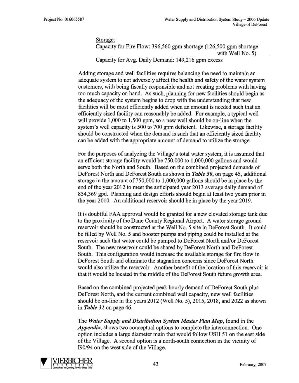
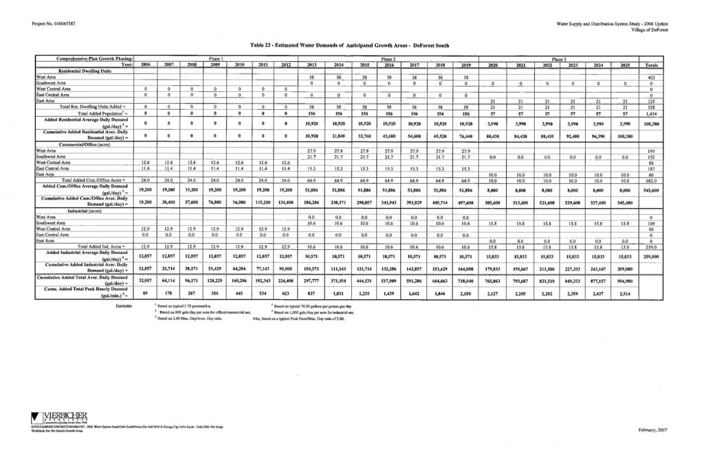
19 Figure 3: Northeast Interceptor DeForest Extension Capacity Evaluation The estimated average daily flow from the Land is 128,000 gallons per day (gpd), with an estimated peak flow rate of 511,700 gpd as shown in the Estimated Wastewater Flows Yahara Gateway Land table found in the Appendices. The sum of the estimated peak hourly flow from the Land and the current estimated peak hourly flow in the Waunakee-DeForest Interceptor shown in Figure 4 below is less than the interceptor capacity. Therefore, the interceptor has adequate capacity to serve the Land. On behalf of MMSD, Strand Associates completed the Pump Station 14 Infiltration/Inflow Study in This study included flow monitoring at a manhole (MH14-130) downstream of the section of the MMSD interceptor (MH to MH14-143) that will serve the Land. The result of the flow monitoring is summarized in Figure 4 below. The measured average daily and the estimated peak hourly flows are well below the rated interceptor capacity, and also well below CARPC s 2009 estimates due to slower-than-projected growth. Monitoring Manhole Figure 4: Current Flows to MMSD s Interceptor Measured Average Daily Flow (gpd) MMSD Peaking Factor Estimated Peak Hourly Flow (gpd) Interceptor Capacity (gpd) MH ,600, ,400,000 9,630,000 8 Utilities Municipal Water Service The Village of DeForest owns and operates two hydraulically separate water supply systems. The DeForest North system, which serves lands in the Village north of Windsor Road, includes active Wells No. 2, 3, 4. The DeForest South system was acquired from the Token Creek Sanitary District in This system includes Well Nos. 1 and 5. The Yahara Gateway Land is proposed to be served with water from the DeForest South system, but the Village intends to also interconnect the two water systems in conjunction with development of the Land. See the detailed discussion of that interconnection below. NUSA AMENDMENT APPLICATION, Page 18
20 Water Supply Wells No. 1 and 5 have pumping capacities of 810 gallons per minute (gpm) and 1,600 gpm respectively, for a total well capacity of 2,410 gpm. Based on the year 2016 pumping records, the average daily demand of the DeForest South system is 64,863 gallons per day (gpd), and the maximum day demand was 230,000 gpd. Applying a peak hour to maximum day factor of 2.0 to the maximum day demand, the peak hourly demand is estimated to be 320 gpm. Storage Storage is provided by a 200,000 gallon elevated tank with an over flow elevation of 1,060 feet, a high water level of 1,058 feet, and a low operating level of 1,049 feet (USGS Datum). Even at the middle of its operating capacity, static pressures would range from 51 pounds per square inch (psi) at the highest elevation within the Land (936 feet) to 82 psi at the lowest elevation (865 feet). This range of static pressures falls within the acceptable range of 35 psi to 100 psi per Chapter NR 811 of the Wisconsin Administrative Code. Distribution Map 6 depicts the proposed water distribution system. Currently, the Village of DeForest water distribution system is extended from east of the Interstate to the intersection of Highway 19 and Liuna Way with a 12 main. To serve the Land, a new 12 water main will be extended across Highway 19 under a future north-south road across from the western intersection of Liuna Way and Highway 19. The 12 water main will be extended to the northern boundary of the Land as development continues. Water distribution mains (8, 10, 12 ) will be extended throughout the remainder of the Land as needed to meet the requirements of proposed development. The distribution system will be looped within the Land, including a secondary connection into the development across from the eastern intersection of Liuna Way and STH 19. This development is called Union Conservancy Park. System Evaluation CARPC requires an available fire flow of 2,000 gpm for a duration of 2.5 hours to be provided under the peak hour demand condition. The current estimated peak hourly demand of the DeForest South System is 320 gpm. The Yahara Gateway Land is projected to generate an average daily demand of 125,200 gpd, a maximum day demand of 195,200 gpd, and a peak hourly demand of 270 gpm as shown in the Estimated Water Demands Yahara Gateway Land table in the Appendices. Therefore, the total estimated peak hour demand of the current DeForest South System plus the proposed Yahara Gateway Land is 590 gpm. An evaluation of the system capacity to provide the peak hourly demand plus fire flow follows: Peak Hourly Demand: Fire Flow: Pumping Capacity: Rate Required from Storage: Volume Required from Storage: (180 gpm)(2.5 hrs)(60 min/hr) = 27,000 gallons 590 gpm +2,000 gpm - 2,410 gpm 180 gpm NUSA AMENDMENT APPLICATION, Page 19
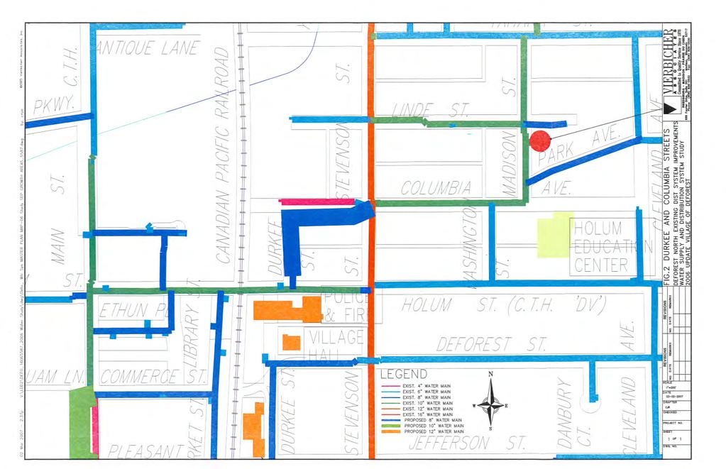
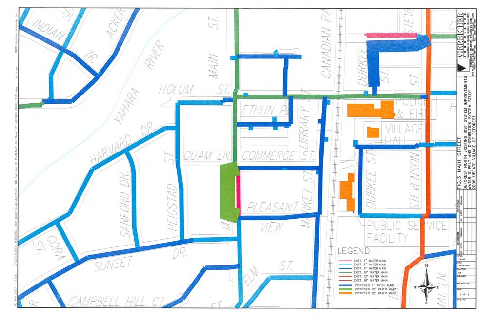
21 The Village presently has 200,000 gallons of total storage with the elevated tank completely full. Since the tanks are usually not operating completely full, the effective storage is considered to be 80% of total storage. This leaves approximately 160,000 gallons of available effective storage. With both well pumps in operation, 27,000 gallons of storage is required to provide the required fire flow for the required duration. The effective elevated storage of 160,000 gallons is greater than the required 27,000 gallons. Therefore, the system has adequate capacity to provide the required fire flow. Computer modeling of extending the Village s water distribution system to the Yahara Gateway Land estimates an available fire flow of 2,080 gpm at a minimum residual pressure of 20 psi. Therefore, the Village s distribution system has adequate capacity to provide the CARPC required 2,000 gpm available fire flow. A summary of the computer modeling results can be found in the Appendices. Water System Interconnection The Village s 2006 Water Supply and Distribution Study includes recommended interconnection between the DeForest North and DeForest South water systems in the area of the Yahara Gateway Lands. The hydraulic grade line of the North system is above that of the South system. Therefore, the North system can contribute flow to the South system through the interconnection. Controlling the amount of flow can be achieved by use of a pressure control valve (PCV). The PCV can be set to allow flow from the North to South systems when pressure in the South system drops to a preset value. Once the pressure in the South system has been restored by flow from the North system to a preset value, the PCV will close and stop flow from the North system. In this way, the North system will provide redundant water supply and storage backup to the South system. This will also provide a viable looped connection to the Yahara Gateway Lands, and other developable lands west of Interstate The interconnection will also allow for the South system to provide water to the North system. In order to provide flow from the South system to the North system, a booster station will be required to overcome the hydraulic difference between the two systems. The South system booster station could be used in rotation with the wells in the North system. In this way, the South system can share its excess storage volume with the North system. The interconnection facility incorporating the PCV and the booster station will be constructed and connected to the water main extended to the northern boundary of the Yahara Gateway Lands, as described in the Distribution subsection above. North of the Land, the water main providing the interconnection will follow a route to be determined along the west side of Interstate , crossing the Interstate near the River Road overpass and ultimately connecting to a water main within Conservancy Place. Based on the recommendations of DeForest s Water Supply and Distribution Study, the Village anticipates interconnecting North and South systems in this area within approximately five years, depending on the actual pace and extent of development of the Yahara Gateway Land. NUSA AMENDMENT APPLICATION, Page 20
22
23 9 Stormwater Management These lands are within the Upper Yahara River watershed. The Land generally slopes off from a high point located in the northeast corner to the north, northwest, and southwest. Areas flowing to the north and northwest generally sheet flows to the Yahara River. Water to the southwest sheet flows to the Yahara River and to a ditch along Highway 19, which eventually flows to the Yahara River. Stormwater management for the Land will be regulated by the Village of DeForest s Chapter 24 Erosion Control and Stormwater Management Ordinance and Section NR 151 of the Wisconsin Administrative Code. Stormwater management plans and practices will meet these local and State requirements for peak flow control, TSS removal, infiltration, and groundwater recharge. Village ordinance standards meet or exceed State and County requirements, and include: 100% volume control for all development conditions based on the Average Annual Rain Series for Madison. Groundwater recharge rates meeting or exceeding average annual recharge rates as estimated by the Wisconsin Geological and Natural History Survey in a report titled Groundwater Recharge in Dane County, Wisconsin Estimated by a GIS-Based Water Balance Model. Maintain pre-development peak runoff rates for the 1-year, 2-year, 5-year, 10-year, 25- year, and 100-year, 24-hour storm events. Encourage use of low impact design techniques to treat storm water runoff at its source. Plans for stormwater management and erosion control will include the installation of specific BMPs in strategic locations prior to any other ground disturbing activities. Erosion control practices will consist of BMPs necessary to limit sediment from leaving the site during ground disturbing activities. Ground disturbing activities will be limited to phases as much as practical to reduce the area of exposed soil. Temporary sedimentation basins may be constructed to prevent soil from leaving the site. Infiltration practices will be implemented following substantial grading and restoration of the site. Conceptual stormwater basins are shown on Map 5, though precise configurations and locations are likely to change. These basins will, in certain cases, serve a single large user and on other occasions will serve multiple development sites and users. Where serving multiple development sites and users, the basins will generally be Village owned and maintained. Where serving a single user, the basins will generally be owned and maintained by that user. The Village requires the recording of stormwater management maintenance agreements prior to the finalization of any stormwater management permit associated with stormwater facilities that are to be privately maintained. NUSA AMENDMENT APPLICATION, Page 22
24 10 Transportation WisDOT is in the process of developing plans for a proposed project on Highway 19 directly south of the Land. This budgeted project will convert Highway 19 from a two-lane to a four-lane highway from just west of River Road to the Interstate interchange. Included with the project is the construction of a new Yahara River bridges and reconstruction of the River Road intersection as a roundabout. Final design plans for this expansion will begin in 2018 and road construction on Highway 19 is anticipated in The planned road network shown on Maps 5 and 6 will serve the anticipated development within the Yahara Gateway Land and be in accordance with DeForest s Comprehensive Plan and Official Map. The Village is currently undertaking a traffic impact analysis to determine appropriate improvements for street intersections between the Land and Highway 19. At present, the Village envisions the western intersection (at Liuna Way) as a signalized intersection, and the eastern intersection with Highway 19 as a right-in, right-out intersection. River Road is a minor arterial road west of Interstate While River Road does not provide a direct connection to the Land, it does serve as a north-south route to downtown DeForest when heading west along on Highway 19. Another route providing access to the northern part of DeForest is Highway CV, just east of the Interstate interchange. The Village s subdivision ordinance requires sidewalk along all public streets, which will be provided with the development of the Land. The Village s Park and Open Space Plan includes conceptual planned trails along Highway 19 and along River Road. These are also represented on Map 5. The Village would like to work with WisDOT, Dane County, the Town of Westport, and others to connect these two conceptual trails to each other and south to the Madison area. The Land is not presently served by bus, taxi or designated carpool facilities. As represented on Map 4, DeForest and the Madison Area MPO envision an express bus route along Interstate As part of its June 2015 Southwest Region Park-and-Ride System Study, WisDOT advised improvements to the park-and-ride lot at the Interstate 39/Highway V interchange, about four miles north of the Land. Three potential future park-and-ride locations in the DeForest-Windsor area were also evaluated, included the Interstate 39/Highway 19 interchange area. Of these sites, the Interstate 39/Highway 19 location ranked among the top 50 in the Southwest Region (#9). NUSA AMENDMENT APPLICATION, Page 23
25 11 Community Facilities and Services The Land will be provided with the full range of urban services. In conjunction with overlapping and adjacent districts, the Village of DeForest offers a full range of municipal services including public sanitary sewer, public water, police and fire protection, solid waste collection, streets and public works maintenance, and a park and open space system. The recently-expanded Public Safety Building in downtown DeForest houses the DeForest Police Department, the DeForest/Windsor Municipal Court, and the DeForest Area Fire and EMS District. The Public Safety Building is located four miles north of the Yahara Gateway Land. The DeForest Police Department does and will provide protective services to the Land. This is a full service department operating 24 hours a day, seven days a week with 17 full time police officers with plans to expand. The Department operates under the State Statute governing mutual aid, providing assistance to other departments when requested. In addition, the Dane County s Sheriff s Department, operating a satellite office in the Windsor Village Hall, provides assistance to the DeForest Police Department when requested if its officers are available. The DeForest-Windsor Fire and EMS Department serves the Land. The station is staffed between the hours of 6 a.m. and 10 p.m. on weekdays. The Department consists of over 40 professional volunteers and four full-time employees. Most personnel are cross-trained as both Firefighters and Emergency Medical Technicians (EMTs). Average overall turn-out time (time from dispatch to enroute) for 2016 was 3:52 minutes. The Village of DeForest contracts with Advanced Disposal Services for automated trash and recycling collection. Commercial and industrial users are expected to privately contract for waste and recycling collection. Per the Village subdivision ordinance, the dedication of park land and park improvement fees are required with new residential development, based on the number and type of housing units. Housing units are not expected to develop here until after 2020, at which point a proposed mini park area may be most appropriately sited in the Yahara District, perhaps linked in some way to the Yahara River corridor. Typically, mini parks include specialized facilities that serve a specific population living nearby, such as children or senior citizens. NUSA AMENDMENT APPLICATION, Page 24
26 12 Appendices A. Planning and Zoning Commission Resolution Verifying Comprehensive Plan Consistency B. Village Board Resolution Authorizing Submittal C. Letter of Support from Village of Windsor D. Estimated Wastewater Flows - Yahara Gateway Land E. Estimated Water Demands - Yahara Gateway Land F. Fire Flow Simulation Results Summary Table Yahara Gateway Land G Village of DeForest Water Supply and Distribution Study (separate document) NUSA AMENDMENT APPLICATION, Page 25
27 Appendix A
28 Appendix A
29 Appendix B
30 Appendix B

31 Appendix B
32 Appendix C ~"~ ~ ~ Windsor Growing Forward Capital Area Regional Planning Commission Attn: Director for Environmental Resources Planning - Mike Rupiper City County Building 210 Martin Luther King Jr. Blvd, Room 362 Madison, WI April 4, 2017 Dear Mr. Rupiper, On behalf of the Village of Windsor, we wish to present you with a letter of support for the Village of DeForest Urban Service Area application for property north of Highway 19 and west of the 139/90/94. Recently, the Village of DeForest attached the property known as Windsor Gateway LLC. This annexation was anticipated as part of the original Cooperative Plan between the Villages of Windsor and DeForest. The Yahara Hills and Ballweg property have not submitted an attachment/detachment request at this time, however, should a request come forward, the attachment/detachment would be consistent with Amendment # 1 to the Cooperative Plan which is under review by the Department of Administration. Because these properties will ultimately be within the Village of DeForest Municipal Boundary and served by their utilities, we wish to express our support for the inclusion of all the subject properties at this time for the Urban Service Area request. In addition, the concept plan is consistent with the Village of Windsor Comprehensive Plan for the area. ~[.ù~ Director of Planning and Development amy@windsorwi.gov Robert E Wipperfurth Village of Windsor President rwipperfurth@windsorwi.gov Village of Windsor Mueller Road, DeForest, WI Phone (608) Fax (608)
33 Appendix D Estimated Wastewater Flows Yahara Gateway Lands Printed: 4/10/2017, 11:19 AM Land Use Acres Number of Units Population Average Daily Flow Rate (gpd) Peak Flow Rate (gpd) Street Right-of-Way Environmental Corridor Non-Stormwater Environmental Corridor -Stormwater Agricultural District Multiple Family Residential , , Institutional ,512 14, Office ,560 30, Commercial Services ,488 65, Retail , , Parks and Open Space Hospitality ,912 47, Totals = , , Factors: Multi-Family Residential Unit Density = 22.5 units/acre Multi-Family Residential Capita per Unit = 1.8 persons per unit Per Person Demand/Sewage Generation Rate 1 = 85.0 gals./day*person Institutional/Office/Commercial/Retail/Hospitality 0 /acre*day Sewage Generation Rate gals./acre = Parks & Open Space Sewage Generation Rate = 00.0 gals./acre*day Peak Flow Rate (cfs) Residential Peaking Factor = Commercial Peaking Factor = Footnotes: (1) Per Table 2-9 Typical Wastewater Flow rates from Residential Sources, Wastewater Engineering, Metcalf & Eddy, 1991 Edition. (2) Chapter 2, pages 26 & 27, Wastewater Engineering, Metcalf & Eddy, 1991 Edition. R:\DeForest, Village of\ TID No. 8\200 - Urban Service Area\Sanitary Analysis\ WW GenEstimate-Defo-TID 8 Worksheet: WW Gen Est Table of 1
34 Appendix E Estimated Water Demands Yahara Gateway Lands Printed: 4/10/2017, 11:18 AM Land Use Acres Number of Units Average Daily Water Demand (gpd) Maximum Day Water Demand (gpd) Peak Hour Water Demand (gpm) Street Right-of-Way Environmental Corridor Non-Stormwater Environmental Corridor -Stormwater Agricultural District Multiple Family Residential ,400 91, Institutional ,512 5,479 8 Office ,560 11, Commercial Services ,488 25, Retail ,248 42, Parks and Open Space Hospitality ,912 18, Totals= , , Factors: Multi-Family Residential Unit Density = Per Residential Customer Water Demand 1 = Institutional/Office/Commercial/Retail/Hospitality Demand 2 = Parks & Open Space Water Demand = 22.5 units/acre gals/day*customer gals./acre*day 00.0 gals./acre*day Maximum Day/Average Day Factor = 1.6 Peak Hour/Maximum Day Factor = 2.0 Footnotes: (1) Per Village of DeForest year 2015 residential water sales reported to PSCW. (2) Chapter 2, pages 26 & 27, Wastewater Engineering, Metcalf & Eddy, 1991 Edition. R:\DeForest, Village of\ TID No. 8\200 - Urban Service Area\Water System Analysis\ WaterDemands-Defo-TID 8 Worksheet: Water Demand Estimate of 1
35 Active Scenario: Maximum Day Fire Flow Node FlexTable: Fire Flow Report Is Fire Flow Run Balanced? Junction w/ Minimum Pressure (System) Junction w/ Minimum Pressure (Zone) Pressure (Calculated Zone Lower Limit) (psi) Pressure (Zone Lower Limit) (psi) Pressure (Residual Lower Limit) (psi) Pressure (Calculated Residual) (psi) Flow (Total Needed) (gpm) Flow (Total Available) (gpm) Fire Flow (Needed) (gpm) Fire Flow (Available) (gpm) Satisfies Fire Flow Constraints? Fire Flow Iterations Zone Label True PMP-Well 5 J , , , , True 23 <None> J-156 True PMP-Well 5 J , , , , True 23 <None> J-157 True PMP-Well 5 J , , , , True 23 <None> J-158 True PMP-Well 5 J , , , , True 23 <None> J-159 True PMP-Well 5 J , , , , True 8 <None> J-163 True PMP-Well 5 J , , , , True 23 <None> J-160 True PMP-Well 5 J , , , , True 23 <None> J-165 True PMP-Well 5 J , , , , True 23 <None> J-161 True PMP-Well 5 J , , , , True 4 <None> J-162 2, Zone-1 J-2 2, Zone-1 J-3 2, Zone-1 J-4 2, Zone-1 J-5 2, Zone-1 J-6 2, Zone-1 J-7 2, Zone-1 J-8 2, Zone-1 J-9 2, Zone-1 J-10 2, Zone-1 J-11 2, Zone-1 J-12 2, Zone-1 J-13 2, Zone-1 J-14 2, Zone-1 J-15 2, Zone-1 J-16 2, Zone-1 J-17 2, Zone-1 J-18 2, Zone-1 J-19 2, Zone-1 J-20 2, Zone-1 J-21 2, Zone-1 J-22 2, Zone-1 J-23 2, Zone-1 J-24 2, Zone-1 J-25 2, Zone-1 J-26 2, Zone-1 J-27 2, Zone-1 J-28 2, Zone-1 J-29 2, Zone-1 J-30 2, Zone-1 J-31 2, Zone-1 J-32 2, Zone-1 WELL 1 2, Zone-1 J-34 2, Zone-1 J-35 2, Zone-1 J-36 2, Zone-1 J-37 2, Zone-1 J-38 Page 1 of 4 Engineer: Darrin R Pope, PE R:\DeForest, Village of\ TID No. 8\200 - Urban Service Area\Water System Analysis\Water System Model 3/27/2017 Company: Vierbicher Associates, Inc. Bentley WaterCAD CONNECT Edition [ ] Appendix F
36 P-180 P-59 P-46 P-48 Appendix F Scenario: Maximum Day Active Scenario: Maximum Day J-165 P-9 P-190 P-182 J-161 P-183 J-162 J-160 P-181 P-184 Color Coding Legend J-159 P-189 J-163 Pipe: Diameter (in) <= 4.0 P-185 <= 6.0 <= 8.0 J-158 P-186 J-157 P-187 J-156 J-101 P <= 10.0 <= 12.0 <= 16.0 Other P-179 J-144 P-165 P-58 J-55 J-54 J-53 J-52 P-57 P-56 P-55 J-56 J-57 P-54 P-188 J-51 J-50 J-49 J-48 P-53 P-52 P-51 P-50 P-49 J-47 J-46 P-45P-44 J-45 P-47 P-43 J-2 P-42 P-41 P-40P-39 J-43J-42 J-41 J-44 J-40 J-39 J-38 P-100 P-101 J-100 Bentley WaterCAD CONNECT Edition [ ] R:\DeForest, Village of\ TID No. 8\200 - Urban Service Area\Water System Analysis\Water System Model Company: Vierbicher Associates, Inc. Engineer: Darrin R Pope, PE 3/27/2017 Page 1 of 1
37
38
39
40
41
42
43
44
45
46
47
48
49
50
51
52
53
54
55
56
57

58
59
60
61
62
63
64
65
66
67
68
69
70
71
72
73
74
75
76
77
78
79
80
81
82
83
84
85
86
87
88
89
90
91
92
93
94
95
96
97
98
99
100
101
102
103
104
105
106
107
108
109
110
111
112
113
114
115
116
117
118
119
120
121
122
123
124
125
126
127
128
129
130
131
132
USA Addition of South & East Side Residential Parcels. USA Deletion of a Town of Christiana Parcel. Conversion from USA to Limited Service Area
 Village of Rockdale Village of Rockdale 148 Water Street Cambridge, WI 53523 Phone 608.423.1497 Fax 608.423.9694 Urban Service Area (USA) Amendment USA Addition of South & East Side Residential Parcels
Gold Line Bus Rapid Transit Transit Oriented Development (BRTOD) Helmo Station Area Plan
 Helmo Station Area Plan") Appendix F Gold Line Bus Rapid Transit Transit Oriented Development (BRTOD) Helmo Station Area Plan Introduction and Purpose of the Plan The Gold Line Bus Rapid Transit facility is an eleven-mile dedicated
Appendix F Gold Line Bus Rapid Transit Transit Oriented Development (BRTOD) Helmo Station Area Plan Introduction and Purpose of the Plan The Gold Line Bus Rapid Transit facility is an eleven-mile dedicated
Chapter 10 IMPLEMENTATION RECOMMENDATIONS
 Chapter 10 IMPLEMENTATION RECOMMENDATIONS The recommended land use plan presented in the previous chapter provides a design for the attainment of the urban and rural development and open space preservation
S o u t h C e n t r a l O u t l i n e P l a n. Leduc Business Park. North Leduc Industrial Area Structure Plan C it y of Led u c.
 Leduc Business Park North Leduc Industrial Area Structure Plan C it y of Led u c Prepared for Farm Air Properties Inc. January, 2007 Table of Contents Page Number 1.0 Purpose of Plan and Definition of
Leduc Industrial Outline Plan SE W4
 Leduc Industrial Outline Plan SE 1-50-25-W4 Within the North Leduc Industrial ASP Prepared for: Leduc Energy Park Ltd. Prepared by: Stantec Consulting Ltd. File No. 1161 104655 V5 Table of Contents 1.0
Ten Mile Creek Planning Area
 PLANNING AREA POLICIES TEN MILE CREEK Ten Mile Creek Planning Area Location and Context The Ten Mile Creek Planning Area ( Ten Mile Creek area ) is located south of the current Boise AOCI, generally south
Table 1: Central Urban Service Area Sprecher Neighborhood, City of Madison
 Staff Analysis of Proposed Amendment to the Dane County Water Quality Plan Revising the Central Urban Service Area Boundary and Environmental Corridors within the Sprecher Neighborhood in the City of Madison
TEMPLE MEDICAL & EDUCATION DISTRICT
 City of Temple, Texas TEMPLE MEDICAL & EDUCATION DISTRICT 1 Description. The City of Temple joined in partnership with key public and private entities to jointly promote education and medical activities
Mitchell Ranch South MPUD Application for Master Planned Unit Development Approval Project Narrative. Introduction
 Mitchell Ranch South MPUD Application for Master Planned Unit Development Approval Project Narrative Introduction Mitchell Ranch South is a proposed single family (detached) residential development on
City of Sun Prairie Wetland Buffer Reduction Request
 City of Sun Prairie Wetland Buffer Reduction Request Westside Development Area January 9, 2017 Prepared by: City of Sun Prairie 300 E. Main Street Sun Prairie, WI 53590 BACKGROUND The City of Sun Prairie
Amendment to the Elderberry Neighborhood Development Plan
 Amendment to the Elderberry Neighborhood Development Plan Recommendations for Land Use, Transportation and Development July 13, 2018 City of Madison, Wisconsin Department of Planning and Community and
Description of Preferred Alternative
 Chapter 2 Description of Preferred Alternative 2.1 Introduction This chapter of the programmatic Sammamish Town Center Sub-area Plan Final EIS provides a more detailed description of the Preferred Alternative
Improve Neighborhood Design and Reduce Non Point Source Water Pollution
 HOW TO Planning Guide Improve Neighborhood Design and Reduce Non Point Source Water Pollution This document was funded by a grant from the New Hampshire Coastal Program with funding from the National Oceanic
Drexel, Barrell & Co.
 Drexel, Barrell & Co. June 18, 2018 Engineers/Surveyors Boulder Colorado Springs Greeley 3 South 7 th Street Colorado Springs, Colorado 80905-1501 719 260-0887 719 260-8352 Fax El Paso County Planning
OP Council Resolution June 16, Planning and Development Services
 OP-08-01 Council Resolution June 16, 2008 Planning and Development Services Kingsgate Landing Outline Plan Table of Contents 1.0 Introduction 1 1.1 Purpose of Plan 1 1.2 Plan Area Location 1 1.3 Ownership
SHEFFIELD PARK Paulding County, GA DRI #588
 SHEFFIELD PARK Paulding County, GA DRI #588 Supplemental Information for RDC s DRI (Form 2) Review August 16, 2004 Prepared for: Mr. David Howerin Coosa Valley RDC 1 Jackson Hill Drive Rome, GA 30161 P.O.
PRELIMINARY REPORT. HIGHWAY 18 CORRIDOR NEIGHBORHOOD PLAN VILLAGE OF DOUSMAN November, 2014
 PRELIMINARY REPORT HIGHWAY 18 CORRIDOR NEIGHBORHOOD PLAN VILLAGE OF DOUSMAN November, 2014 This preliminary report presents the initial recommendations for land use within the Highway 18 corridor along
BUILDER LOTS FOR SALE
 BUILDER LOTS FOR SALE NORTHERN CULPEPER - 135 ACRES RESIDENTIAL DEVELOPMENT 1256 Old Bridge Road, Amissville, VA 20106 SALE PRICE: $995,000 LOT SIZE: 135+ Acres APN #: Tax Map 2 Parcel 23 ZONING: R-1 ACCESS:
Drexel, Barrell & Co.
 Drexel, Barrell & Co. December 21, 2018 Engineers/Surveyors Boulder Colorado Springs Greeley 3 South 7 th Street Colorado Springs, Colorado 80905-1501 719 260-0887 719 260-8352 Fax El Paso County Planning
Major Subdivision Sketch Plan Checklist
 This checklist provides specific requirements that are apart of the Sketch process. The entire process is described by the Huntersville Subdivision Review Process which details all the submittal and resubmittal
TO: Mayor & Council DATE: April 12, The Planning and Development Department and the Engineering Department recommend that Council:
 CORPORATE REPORT NO: R080 COUNCIL DATE: April 12, 2010 REGULAR COUNCIL TO: Mayor & Council DATE: April 12, 2010 FROM: SUBJECT: General Manager, Planning and Development General Manager, Engineering Neighbourhood
Request for Statement of Interest in Implementation of the Roosevelt Road Redevelopment Plan
 425 Hillside Avenue Request for Statement of Interest in Implementation of the Roosevelt Road Redevelopment Plan I. INTRODUCTION The is seeking the services of a qualified consulting firm to prepare plans
The transportation system in a community is an
 7 TRANSPORTATION The transportation system in a community is an important factor contributing to the quality of life of the residents. Without a sound transportation system to bring both goods and patrons
9 th Street Sub Area Plan
 9 th Street Sub Area Plan In the 1990 s, when the Township prepared the last Master Plan, the 9 th Street corridor was studied as part of a larger 9 th Street Focus Area that included the West Main Street
Chapter 5: Natural Resources and Environment
 NATURAL RESOURCES AND ENVIRONMENT 5-1 5 Chapter 5: Natural Resources and Environment BACKGROUND AND INTENT Urban expansion represents the greatest risk for the future degradation of existing natural areas,
Watertown City Council
 City of Watertown Watertown City Council April 14 th, 2015 Agenda Item: City Comment on Sun Share CUP Application Request for Action: Motion to Approve City Comments regarding CUP Application Department:
THREE-STEP DESIGN PROCESS FOR OPEN SPACE SUBDIVISIONS
 00216106.DOC NMA/RRK 1/30/14 THREE-STEP DESIGN PROCESS FOR OPEN SPACE SUBDIVISIONS Open space subdivisions, sometimes called cluster developments, maintain a significant portion of a development site in
Implementation Vision
 Introduction The implementation chapter is the how to portion of the plan. It describes the actions necessary to realize the visions presented in this document through the goals, objectives, and policies
Planning Districts INTRODUCTION
 INTRODUCTION To facilitate detailed examination of development prospects for all areas of the community, Delano has been divided into 14 planning districts. The location of these planning districts is
Land Use Amendment in Southwood (Ward 11) at and Elbow Drive SW, LOC
 at and Elbow Drive SW, LOC") 2018 November 15 Page 1 of 10 EXECUTIVE SUMMARY This land use amendment application was submitted by Rick Balbi Architect on 2017 August 31 on behalf of Sable Developments Ltd, and with authorization from
2018 November 15 Page 1 of 10 EXECUTIVE SUMMARY This land use amendment application was submitted by Rick Balbi Architect on 2017 August 31 on behalf of Sable Developments Ltd, and with authorization from
A citizen s guide to the. Comprehensive Plan. City of Lakeville, Minnesota 1
 A citizen s guide to the Comprehensive Plan 2008 City of Lakeville, Minnesota 1 Introduction The City of Lakeville completed an update of its Comprehensive Plan in 2008. A comprehensive plan is a tool
Transportation. Strategies for Action
 Transportation A major priority for the Overlake Neighborhood is to develop a multimodal transportation system. To achieve this system, a balance has to be found among travel, circulation and access needs;
October 25, Mr. Cody Riddle, Current Planning Manager Planning & Development Services City of Boise 150 N. Capitol Boulevard Boise, ID 83706
 October 25, 2016 Mr. Cody Riddle, Current Planning Manager Planning & Development Services City of Boise 150 N. Capitol Boulevard Boise, ID 83706 RE: Rush Valley East Columbia Road Annexation, Zoning and
BROOKHILL NEIGHBORHOOD MODEL ZONING MAP AMENDMENT PREFACE TO APPLICATION
 BROOKHILL NEIGHBORHOOD MODEL ZONING MAP AMENDMENT PREFACE TO APPLICATION June 15, 2015 Revised: August 1, 2016 I. VISION Brookhill is a proposed community based upon the principles of Albemarle County
Implementation Guide Comprehensive Plan City of Allen
 Implementation Guide 2030 Comprehensive Plan City of Allen DRAFT 2015 Implementation Guide Allen 2030 Comprehensive Plan INTRODUCTION The Comprehensive Plan serves as a guide for the growth and development
Secrest Short Cut and Monroe Expressway Small Area Plan AUGUST 29, 2018
 Secrest Short Cut and Monroe Expressway Small Area Plan AUGUST 29, 2018 Background and Process Monroe Expressway will be open by the end of 2018 Union County and Indian Trail identified a need to revisit
Hockessin Community Redevelopment Plan
 Hockessin Community Redevelopment Plan 3.1 Introduction The Community Redevelopment Plan for the Village of Hockessin is the result of the people s vision for a distinct village center that serves as the
GOALS, OBJECTIVES, POLICIES & PROGRAMS
 Chapter 5 GOALS, OBJECTIVES, POLICIES & PROGRAMS 5.1 Goals, Objectives, Policies & Programs This is a joint plan adopted by both the Village of Waunakee and the Town of Westport. Both communities will
City of Grande Prairie Development Services Department
 City of Grande Prairie Development Services Department ROYAL OAKS NORTH OUTLINE PLAN OP-07-03 NW 35-71-6 W6M May 7, 2007 Royal Oaks North Outline Plan TABLE OF CONTENTS 1.0 INTRODUCTION........ 3 1.1 Purpose
Town of Peru Comprehensive Plan Executive Summary
 Town of Peru Comprehensive Plan Executive Communities that plan grow by choice, not by chance. A plan makes growth thoughtful, understandable, and predictable. A plan shows that a community is managing
CHAPTER 7: Transportation, Mobility and Circulation
 AGLE AREA COMMUNITY Plan CHAPTER 7 CHAPTER 7: Transportation, Mobility and Circulation Transportation, Mobility and Circulation The purpose of the Transportation, Mobility and Circulation Chapter is to
Appendix I-A3 DENAIR COMMUNITY PLAN
 Appendix I-A3 DENAIR COMMUNITY PLAN Adopted by the Stanislaus County Board of Supervisors DECEMBER 15, 1998* *A technical update removing reference to the former Stanislaus County Redevelopment Agency
This Review Is Divided Into Two Phases:
 Semiahmoo Town Centre Review The purpose of this review: To review the Semiahmoo Town Centre Concept Plan, originally approved in 1993, to ensure that this centre will continue to serve the needs of South
Appendix I. Checklists
 Appendix I Checklists Town of Greenwich Drainage Manual Department of Public Works - Engineering Division Town Hall - 101 Field Point Road, Greenwich, CT 06836-2540 Phone 203-622-7767 - Fax 203-622-7747
Regional Context Statement
 Regional Context Statement REGIONAL CONTEXT STATEMENT 3. REGIONAL CONTEXT STATEMENT In 1995, the Provincial Government passed into law the Growth Strategies Act. The purpose of this provincial initiative
PLANNED UNIT DEVELOPMENT & SUBDIVISION STAFF REPORT Date: May 18, 2017
 & PUD-0000102-2017 PLANNED UNIT DEVELOPMENT & SUBDIVISION STAFF REPORT Date: May 18, 2017 NAME SUBDIVISION NAME Dauphin Creek Estates Subdivision Dauphin Creek Estates Subdivision LOCATION CITY COUNCIL
HAZARD MITIGATION GOALS AND OBJECTIVES
 SEWRPC Community Assistance Planning Report No. 282, 2nd Edition CITY OF MILWAUKEE ALL HAZARDS MITIGATION PLAN UPDATE Chapter IV HAZARD MITIGATION GOALS AND OBJECTIVES [NOTE: Throughout this plan update
STREAM BUFFERS
 88-415 STREAM BUFFERS 88-415-01 PURPOSE In the Kansas City region and throughout the nation, vegetated stream buffers have been clearly shown to protect stream stability and related infrastructure, improve
COMMUNITY DESIGN. GOAL: Create livable and attractive communities. Intent
 COMMUNITY DESIGN Intent An attractive, well-designed County will attract quality development, instill civic pride, improve the visual character of the community, and create a strong, positive image for
Selected Area Study. Vision Plan Draft
 East Polk County Selected Area Study Draft 10.30.08 Contents Guiding Principles...4 Context Conclusions...5 Current Context...8 Scenarios...9 Scenario: Status Quo...10 Scenario: Connected & Directed Growth...12
Welcome. Walk Around. Talk to Us. Write Down Your Comments
 Welcome This is an information meeting introducing the applications for proposed redevelopment of the Yorkdale Shopping Centre site at 3401 Dufferin Street and 1 Yorkdale Road over the next 20+ years,
ESTABLISH AN EFFICIENT TOWN CENTER
 ESTABLISH AN EFFICIENT TOWN CENTER 4 Overview Lisbon residents are proud of the history of Newent and at the same time recognize its current importance as a centralized location for a variety of municipal
SECTION UNIFIED DEVELOPMENT ORDINANCE SECTION Part 1 Ordinance. ARTICLE 1 Zoning Districts
 SECTION 1-100 UNIFIED DEVELOPMENT ORDINANCE SECTION 1-300 Part 1 Ordinance SECTION 1-100. Introduction. ARTICLE 1 Zoning Districts Crystal Lake strives to maintain a balance of various land uses for a
Central and East Neighbourhoods - Hermitage Outline Plan
 Central and East Neighbourhoods - Hermitage Outline Plan Office Consolidation September 2013 Prepared by: Planning and Policy Services Branch Planning and Development Department City of Edmonton The Central
Chapter 3 Site Planning and Low Impact Development
 CHAPTER 3 Site Planning and Low Impact Development Chapter 3 Site Planning and Low Impact Development 3.0 Introduction The City of Charleston requires that major residential, large commercial (>1 acre),
Chapter 13: Implementation Plan
 Implementation A. Introduction The Implementation Plan, in table form on the following pages, provides a summary of all the Action Items recommended in Chapters 2 through 12. The table also indicates which
General Location Annex, Rezone & Preliminary Plat Lansdowne Addition, Unit Three
 NEWFOUNDLAND I-5 Agricultural District Subject Site SUNDANCE ANDERSON Single Family Residential CHRISTY PUD Agricultural District Highway Business General Location Annex, Rezone & Preliminary Plat Lansdowne
HURON COMMUNITY PLAN
 CITY OF KITCHENER DEPARTMENT OF DEVELOPMENT AND TECHNICAL SERVICES PD 94/7 HURON COMMUNITY PLAN Recommended by Planning and Economic Development Committee: October 31, 1994 Adopted by Kitchener City Council:
The Illinois Department of Transportation and Lake County Division of Transportation. Route 173, including the Millburn Bypass
 The Illinois Department of Transportation and Lake County Division of Transportation welcome you to this Public Hearing for U.S. Route 45 from Illinois Route 132 to Illinois Route 173, including the Millburn
EXECUTIVE SUMMARY DRAFT CHAPTER 1 INTRODUCTION EXECUTIVE SUMMARY
 CHAPTER 1 EXECUTIVE SUMMARY INTRODUCTION Through the joint efforts of the City of Tulsa planning staff and the Land Services division of Indian Nations Council of Governments (INCOG), the Berryhill Land
5.0 Community Design Plan
 5.0 Community Design Plan The Community Design Plan for the Mer Bleue area is a composite of three plans: Land Use Plan Transportation Plan Municipal Servicing Plan Read together, these Plans and associated
EXHIBIT A. Tax Increment Reinvestment Zone No. 1 (Town Center) First Amended Project Plan 1
 First Amended Project Plan 1") EXHIBIT A Tax Increment Reinvestment Zone No. 1 (Town Center) First Amended Project Plan 1 1 As amended by Resolution No. 2008-02-001(TR1R) of the Tax Increment Reinvestment Zone No.1, and approved to
EXHIBIT A Tax Increment Reinvestment Zone No. 1 (Town Center) First Amended Project Plan 1 1 As amended by Resolution No. 2008-02-001(TR1R) of the Tax Increment Reinvestment Zone No.1, and approved to
VANDEN MEADOWS SPECIFIC PLAN TABLE OF CONTENTS Page 1.0 INTRODUCTION SUMMARY Schools Foxboro Parkway
 VANDEN MEADOWS SPECIFIC PLAN TABLE OF CONTENTS Page 1.0 INTRODUCTION 6 1.1. SUMMARY 6 1.1.1. Schools 11 1.1.2. Foxboro Parkway 11 1.1.3. Improvements to Leisure Town Road 11 1.1.4. New Neighborhood Park
Woodburn Comprehensive Plan Growth Management Goals and Policies
 Goal Woodburn Comprehensive Plan Growth Management Goals and Policies G-1. The City's goal is to manage growth in a balanced, orderly and efficient manner, consistent with the City s coordinated population
SPECIFIC PLAN Requirements
 CITY OF LANCASTER PLANNING DEPARTMENT 44933 Fern Avenue, Lancaster, California 93534 (661) 723-6100 SPECIFIC PLAN Requirements Purpose The purpose of a specific plan is to provide for the logical development
PLANNED UNIT DEVELOPMENT Date: April 5, 2018
 PLANNED UNIT DEVELOPMENT Date: April 5, 2018 DEVELOPMENT NAME SUBDIVISION NAME LOCATION Robert Myers Robert Myers 2955 and 2989 Dauphin Street (Southeast corner of Dauphin Street and Sage Avenue) CITY
TIRZ 17/Redevelopment Authority Capital Improvements Plan Projects
 Gessner Widening: T-1701 What: Widen the road from a six-lane divided boulevard to an eight-lane divided boulevard street section, increase turn lanes, update traffic signal system, improve drainage by
4. UTILITIES ELEMENT.
 4. UTILITIES ELEMENT. The purpose of this element is to provide for necessary public facilities and services correlated to future land use projections and population demand. Utilities Sub-Elements (A)
Brice Prairie Master Plan
 Brice Prairie Master Plan Town of Onalaska Community Meeting #1 Sand Lake Elementary School January 28, 2006 9 am 11 am Agenda Background What is a Master Plan? Brice Prairie Capacity Reports Starter Ideas
PUBLIC SERVICES ELEMENT GOALS / POLICIES / MEASURES
 PUBLIC SERVICES ELEMENT GOALS / POLICIES GOALS / POLICIES / MEASURES Authority The Public Services Element addresses provision of municipal services to City residents. The following paragraphs provide
IMPLEMENTATION STRATEGIES. In This Chapter. Goals & Strategies 182 Project List 183 Future Land Use 186 CHAPTER 11 IMPLEMENTATION STRATEGIES
 In This Chapter Goals & Strategies 182 Project List 183 Future Land Use 186 11 IMPLEMENTATION STRATEGIES NORTH AUGUSTA, SC 2017 COMPREHENSIVE PLAN 179 Individual commitment to a group effort that is what
ROAD CLOSURE AND LAND USE AMENDMENT SILVER SPRINGS (WARD 1) NORTHEAST OF NOSEHILL DRIVE NW AND SILVER SPRINGS ROAD NW BYLAWS 2C2018 AND 29D2018
 NORTHEAST OF NOSEHILL DRIVE NW AND SILVER SPRINGS ROAD NW BYLAWS 2C2018 AND 29D2018") Page 1 of 19 EXECUTIVE SUMMARY This application proposes redesignating two parcels in the community of Silver Springs from Special Purpose Future Urban Development (S-FUD) District and undesignated road
Page 1 of 19 EXECUTIVE SUMMARY This application proposes redesignating two parcels in the community of Silver Springs from Special Purpose Future Urban Development (S-FUD) District and undesignated road
Westwind Developments Ltd. PIONEER LANDS AREA STRUCTURE PLAN - PROPOSED AMENDMENT
 FEBRUARY 2013 TABLE OF CONTENTS 1.0 BACKGROUND... 1 1.1 Amendment... 1 2.0 LOCATION & CONTEXT... 2 2.1 Land Ownership... 2 3.0 POLICY CONTEXT... 3 3.1 Municipal Development Plan... 3 3.2 Capital Region
APPENDIX C SPECIAL PLANNING AREAS
 SPECIAL PLANNING AREAS There are five Special Planning Areas (SPAs) on the Land Use Diagram (Figure LU-2). The SPAs are areas with significant new growth potential that require more detailed subsequent
Planning, Property and Development Department Report. To the Riel Community Committee
 Planning, Property and Development Department Report To the Riel Community Committee Date: October 30, 2006 File: SP 5/2006 Subject: Waverley West Northeast Neighbourhood Area Structure Plan Location:
Living in Albemarle County s Urban Places
 Living in Albemarle County s Urban Places ALBEMARLE COUNTY, VIRGINIA A Closer Look at Albemarle s Approach to Managing Growth and Creating Quality Urban Environments www.albemarle.org Page 2 Living in
COUNTY OF ALBEMARLE PLANNING STAFF REPORT SUMMARY
 COUNTY OF ALBEMARLE PLANNING STAFF REPORT SUMMARY Project Name: SP2006-43 Field School Planning Commission Public Hearing: April 4, 2007 Owners: Claudius Crozet Park, Inc. (Robert A. Maupin, President)
City Of Sparks Planning Commission Item
 Page 1 of 12 City Of Sparks Planning Commission Item Meeting Date: May17, 2012 Subject: PCN12009, Public Hearing, Consideration and possible action on a Master Plan Amendment and Rezoning request to change
CHAPTER 4 FUTURE LAND USE AND URBAN SERVICES DISTRICTS
 CHAPTER 4 FUTURE LAND USE AND URBAN SERVICES DISTRICTS Introduction This chapter discusses how Benzie County should grow and change in the future. A community can grow and change in many different ways.
12 January 12, 2011 Public Hearing APPLICANT: TAILWIND DEVELOPMENT GROUP,LLC PROPERTY OWNER: CITY OF VIRGINIA BEACH
 12 January 12, 2011 Public Hearing APPLICANT: TAILWIND DEVELOPMENT GROUP,LLC PROPERTY OWNER: CITY OF VIRGINIA BEACH STAFF PLANNER: Faith Christie REQUEST: Conditional Change of Zoning (from PD-H1 Planned
4-Town Comprehensive Plan DRAFT 7/30/07
 4-Town Comprehensive Plan DRAFT 7/30/07 Acknowledgements ning Committee Town of Harrisburg Norman Roof Randy Nicol Town of Martinsburg Terry Thisse Paul Kelly Town of Montague Jan Bagdanowicz Wendy Perry
Plan Policies. Introduction
 Plan Policies Introduction The purpose of the Plan Policies section is to identify the various Governing Body and Planning Commission land use related policy resolutions for use in evaluating development
3. VISION AND GOALS. Vision Statement. Goals, Objectives and Policies
 Vision Statement Queen Creek s interconnected network of parks, trails, open spaces and recreation opportunities provide safe and diverse activities and programs that sustain its unique, small town, equestrian
Outline Plan in Belvedere (Ward 9) at Street SE, LOC (OP)
 at Street SE, LOC (OP)") 2018 October 04 Page 1 of 12 EXECUTIVE SUMMARY This outline plan application was submitted by B&A Planning Group on 2016 July 15, on behalf of Tristar Communities Inc. for 50.14 hectares (123.89 acres)
2018 October 04 Page 1 of 12 EXECUTIVE SUMMARY This outline plan application was submitted by B&A Planning Group on 2016 July 15, on behalf of Tristar Communities Inc. for 50.14 hectares (123.89 acres)
Section 9 NEIGHBORHOOD DESIGN
 Section 9 NEIGHBORHOOD DESIGN City of Lancaster Comprehensive Plan D u n k i n, S e f k o & A s s o c i a t e s, I n c. NEIGHBORHOOD DESIGN INTRODUCTION There are many ways in which a neighborhood can
BUDGETING FOR OUTCOMES TRINITY RIVER CORRIDOR
 BUDGETING FOR OUTCOMES TRINITY RIVER CORRIDOR Trinity River Corridor Team Members: Kelly High, Streets Department Megan Lam, Office of Financial Services Mike Mikeska, Dallas Water Utilities Diana Ochoa,
Sewanee Village + Request for Builder/Developer Proposals
 Sewanee Village + Request for Builder/Developer Proposals Contact: Frank X. Gladu Special Assistant to the Vice Chancellor University of the South 735 University Ave Version 3 Sewanee TN 37383 Released:
Kirtland, Ohio - Comprehensive Plan Update 2022
 Kirtland, Ohio - 2022 Comprehensive Plan Update November 2012 INTRODUCTION City of Kirtland Officials... 1 Update: Preface... 2 City Charter Requirement: Purpose & Process... 3 THE PLAN Comprehensive Update:
Mark-up of the effect of the proposed Bronte Village Growth Area OPA No.18 on the text of section 24, Bronte Village, of the Livable Oakville Plan
 Mark-up of the effect of the proposed Bronte Village Growth Area OPA No.18 on the text of section 24, Bronte Village, of the Livable Oakville Plan Notes: This document is provided for information purposes
14 October 10, 2012 Public Hearing APPLICANT: MPB, INC
 14 October 10, 2012 Public Hearing APPLICANT: MPB, INC PROPERTY OWNER: MUNDEN & ASSOCIATES, LP STAFF PLANNER: Karen Prochilo REQUEST: Conditional Change of Zoning (AG-1 & AG-2 to Conditional O-2) ADDRESS
Beatties Ford Road & Mt. Holly-Huntersville Road Small Area Plan
 Beatties Ford Road & Mt. Holly-Huntersville Road Small Area Plan Town of Huntersville October 2005 Town of Huntersville Planning Department 101 Huntersville Concord Road Post Office Box 664 Huntersville,
CHAPTER 22 Rural Open Space Community Developments
 CHAPTER 22 Rural Open Space Community Developments Section 22.1 Description and Purpose The intent of this Chapter is to offer property owners an alternative to traditional zoning requirements for rural
Note: Staff reports can be accessed at Zone: I-3. Tier:
 The Maryland-National Capital Park and Planning Commission Prince George s County Planning Department Development Review Division 301-952-3530 Note: Staff reports can be accessed at www.mncppc.org/pgco/planning/plan.htm.
City of Grande Prairie Development Services Department KENNEDY DEVELOPMENTS LTD. OUTLINE PLAN OP-09-01
 City of Grande Prairie Development Services Department KENNEDY DEVELOPMENTS LTD. OUTLINE PLAN OP-09-01 July 27, 2009 TABLE OF CONTENTS 1.0 Introduction... 1 1.1 Plan Area Location & Context... 1 1.2 Ownership
TRANSPORTATION AND LAND USE
 CHAPTER 10 TRANSPORTATION AND LAND USE Transportation and land use are intimately linked. The expansion of a highway typically spurs housing, employment growth and land development in the communities that
Table of Contents. Elm Avenue Improvement Plan City of Waco, Texas. Introduction 1. Existing Context 1 Figure 1 2.
 Table of Contents Introduction 1 Existing Context 1 Figure 1 2 Plan Guidelines 3 Future Urban Form 4 The West-End 4 Main Street 6 The East-End 7 Figure 2 9 Public Improvement Recommendations 7 General
INTRODUCTION PLANNING HISTORY
 INTRODUCTION The Upper Rock Creek Master Plan Area lies in the east central part of Montgomery County. The Master Plan Area is adjacent to the City of Rockville to the south, the Olney Planning Area to
CITY OF TIGARD EXPECTED SERVICE AREA
 CITY OF TIGARD EXPECTED SERVICE AREA City overview / Background Incorporated in 1961, the has experienced rapid growth over the years. This growth can be attributed to many factors, primarily the close
Applicant Name Phone / Fax / Address City State Zip Code . Property Owner Phone / Fax / Address City State Zip Code
 Master Development Plan Application Community Development Department City of Redmond 411 SW 9 th Street Redmond, Oregon 97756 541-923-7721 541-548-0706 FAX Master Development Plan Fee $38,862.52 File Number
Asbury Chapel Subdivision Sketch Plan
 Asbury Chapel Subdivision Sketch Plan PART 1: PROJECT SUMMARY Applicant: NVR Inc. Project Size: +/- 76.13 acres Parcel Numbers: 02101112,02116101,02116112, 02116113 Current Zoning: Transitional Residential