Kingston Waterfront Master Plan
|
|
|
- Howard Chandler
- 6 years ago
- Views:
Transcription

1 Comprehensive Kingston Waterfront Master Plan Public Meeting #1 June 25th, 2014 City of Kingston

2 intro to: a vision for Kingston s waterfront
3 agenda Introductions (5 min) Overview of study (45 min.) Post Card Survey (5 min) Table Activity (45 min) Next Steps (5 min)
4 what is it? A waterfront master plan is a guiding document that: organizes and prioritizes the renewal of public waterfront spaces identifies improvements for access and connectivity along the waterfront
5 Why? consolidate past studies maximize opportunity for enjoyment improve existing connections identify future priorities
6 past studies Approximately 40 studies completed over the past 30 years Address various waterfront areas and waterfront issues within the City This plan will consider all previous work in developing one guiding document
7 past studies Cataraqui River Basin Floodplain Management Study (1977) Grass Creek Proposal (1984) Land Use Study: Inner Harbour Kingston (1984) Master Plan: Kingston s Waterfront (1984) Flood Risk Mapping of Little Cataraqui Creek (1987) South-West Sector Study (1989) Rideau Community Plan (1991) Official Plan of the Kingston Planning Area (1991) Transportation Study: Bridge Crossings of the Cataraqui River (1992) Township of Pittsburgh Greenspace Master Plan (1993) The Foundation: An Inventory of Natural and Cultural Assets (1996) Grass Creek Park Shoreline Study (1995) Grass Creek Park Shoreline Plan Design Brief (1996) Rideau Canal Management Plan (1996) The Great Lakes Maritime Heritage Centre Concept Evaluation (1997) Kingston Waterfront Stabilization Strategy Study (1997) Official Plan of the Township of Kingston (1997) Conceptual Plan for Lemoine Point Conservation Area (1999) Kingston Community Strategic Plan (2000) Master Stormwater Management Plan (2001) Strategic Plan: Cataraqui to 2020 (2001) Green Space Planning for the Little Cataraqui Creek Watershed (2002) Kingston s Waterfront Public Consultation (2002) Kingston Inner Harbour: Report on the Workshop about the Future of the Inner Harbour (2002) Kingston Inner Harbour: Data Compilation and Gap Analysis (2003) Community Waterfront Planning: Towards a Waterfront Strategy for the City of Kingston (2003) Kingston Transportation Master Plan (2003) Cycling and Pathways Study (2003) Downtown Action Plan: An Infrastructure Renewal and Public Open Space Plan (2004) North Block Central Business District Study (2004) Official Plan for the Pittsburgh Planning Area (2004) Rideau Canal National Historic Site of Canada Management Plan (2005) Rideau Canal World Heritage Site Management Plan (2005) Rideau Canal Waterfront Environmental Management Study (2007) Downtown and Harbour Area Architectural Guidelines Study (2007) North Block District Community and Business Enhancement Opportunities (2009) Inner Harbour Trail Feasibility Study (2011) Lake Ontario Park Master Plan (2012) Breakwater Park Master Plan (2013) Grass Creek Park Master Plan (2014) Douglas Fluhrer Park Master Plan (2014)
8 recent park plans Prioritize recently completed plans: - Douglas Fluhrer Park (2014) - Breakwater Park (2013) - Grass Creek Park (2013) - Lake Ontario Park (2012) Identify new priorities
 Grass Creek Park (2013) Lake Ontario Park")
9 recent park plans Douglas Fluhrer Park (2014) Breakwater Park (2013) Grass Creek Park (2013) Lake Ontario Park (2012)

10 maximize assets

11 maximize assets

12 maximize assets

13 maximize assets

14 maximize assets

15 improve waterfront experiences

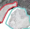
16 back is the new front
17 this...

18 or this... East Bay Front promenade, Toronto
19 this...

20 back or this... the new front Development at the bottom Sugar of Beach, Johnson Toronto Street

21 this...

22 or this... Race Street Pier, Philadelphia

23 linkages Port Union, east Toronto

24 viewing opportunities Port Union, east Toronto

25 viewing opportunities Prince Arthur s Landing, Thunder Bay

26 waterfront access Prince Arthur s Landing, Thunder Bay

27 waterfront access Samuel Champlain Promenade, Quebec City

28 waterfront access Samuel Champlain Promenade, Quebec City
29 waterfront access
30 recreation
31 How is this study different? consolidate past studies review of the entire 280km of shoreline consideration of recent park master plans land access strategy
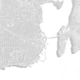
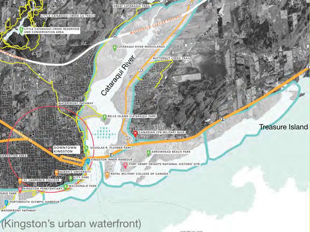
32 study area 16 Reaches* 280 km of shoreline 10,000 hectares both rural and urban areas
33 * what is a reach? a reach is a geographical area of the waterfront that has unique topographical, environmental and land use characteristics. reach has already been used in public consultation on past waterfront planning exercises


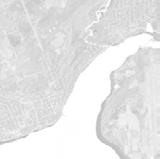


34 the reaches A B


35 full the reaches connectivity 15 Loughborough Lake Collins Lake Rideau Canal 14 16A 16B Deer Ridge Rd Treasure Island Collins Bay 3 5
36 a focus on access connectivity enhancement
37 project overview Produce a guiding document that: Organizes and prioritizes a plan to 1. Improve/renew public waterfront spaces 2. Expand public access to waterfront 3. Increase connectivity along the waterfront Provides overall strategic approach for implementation
38 \ access things (e.g., water, nature) activities (e.g., walking, cycling, fishing, swimming), experiences (e.g., social interaction, vistas, learning about heritage); could mean access to water at specific locations; could mean access for people with limited mobility
39 connectivity in urban area means linkages to and along the waterfront to create full connectivity in rural areas means places/spaces to focus on for improvements, and connections to these from existing roadways, paths
40 study area 15 urban waterfront (full connectivity) rural Lake Ontario and St. Lawrence River waterfront (nodal connectivity) north rural Cataraqui and Rideau River waterfront (nodal connectivity) 14 16A 16B

41 urban waterfronts goal is for full connectivity from Collins Bay to Treasure Island full connectivity means physical connection via an on or off road path connection
42
43
44 full connectivity
45 full connectivity
46 full connectivity
47 rural waterfronts goal is to provide nodal connectivity to waterfront at key destinations nodal connectivity is waterfront access at key locations and may include picnicking areas, boat launches, trails and waterfront viewing
48 full connectivity rural waterfronts 15 Loughborough Lake Collins Lake Rideau Canal 14 16A 16B Deer Ridge Rd Treasure Island Collins Bay 3 5
49 nodal connectivity
50 nodal connectivity
51 nodal connectivity
52 enhancement means tangible improvements to specific places/spaces new repaired expanded natural or constructed
53 our understanding a plan tailored to Kingston link the green spaces recognize the significance of the blue spaces cultural heritage preservation listening to the public implementation priorities and phasing creation of focus areas a clear and understandable document

54 a plan tailored to Kingston


55 link the green spaces

56 recognize the significance of the blue spaces

57 cultural heritage preservation

58 listening to the public

59 implementation priorities + phasing Grass Creek Park

60 implementation priorities + phasing Breakwater Park


61 implementation priorities + phasing C James Street Molly Brant Point Charles Street Dufferin Street Corrigan Street parkette Rideau Street Riverview Park North Street Anglin Bay Bay Street Antillery Park remain be natural - erosion to addressed O H G A F A Bagot Street Montreal Street North Street Hill Park to shoreline is C A McBurney Park to D E F G The Trunk - Walkway of varying widths (2-3+ meters) undulating throughout park - Lights spaced at meter intervals - Hard surface - Links lawns, access points and activity areas Branchways - Fine grain trails - Minor width secondary trails Parking - For park and boat launch users - Preserve view from parking to river - Main parking: public access - South parking: for marina use Trailer Parking - Suitable for boat trailers, associated with marina H I J K L Boat Launch - Associated with marina Potential Wellington Street Extension - Two-way trafflc lane extension - Bike lanes, sidewalks and planted boulevards North Street Access - Accessible pathway (switchback) combined with direct staircase access - Potential courtesy crossing Parkette Connection - Asphalt Walkway Connection Water Access - Canoe and kayak access - Potential community oating dock M N O Activity Zone + Plaza - Playful elements - Event space - Ceremonies - Historical interpretation (e.g. paving pattern inspired by railway tracks) Shade Structure - Metal shade structure to provide sun protection in activity zone Overlooks - Low seatwalls - Planting - Views of water - Interpretation opportunity A P Celtic Cross Relocation - New location subject to discussions with donor/group C shoreline is to P remain natural - erosion B to be addressed A L F A along length of shoreline enhance and make safe existing water access nodes C shoreline is to remain natural - erosion to be addressed C E A D POTENTIAL WELLINGTON N M potential courtesy crossing J STREET I EXTENSION FOR Douglas Fluhrer Park


62 Connection to North Street Parking Future Wellin I K B G D F L creation of focus areas H C Railway Interpretation Overlook Central Lawn Lawn J K L Parkette Connection Asphalt pathway connection Community Gathering Zone Central Node Ceremonies Historical Interpretation Playful Elements Future Shoreline Improvements at Storm Outlet Notes Celtic Cross to be accomodated on site. Location to be determined. Pathway lighting will be part of the detailed plans for implementation. F Overlook Boat Launch E Lawn E Lawn 1:1000 Activity Option m Parking Option m 1:1000 Douglas F Fluhrer Park


63 a clear document Douglas Fluhrer Park Master Plan

64 a clear document Humber Arboretum Pond Master Plan

65 a clear document Grimsby Waterfront Master Plan


66 a clear document Grimsby Waterfront Master Plan

67 project overview four phases over two years 16 Working Group meetings 20 interviews 2 roundtables 3 site visits Graphic? 12 meetings with staff 9 public workshops presentation to Arts Recreation and Community Policies Committee complete by April 2016

68 project overview inventory and assessment of existing conditions land access strategy focus areas (design) Graphic? cost estimates and phasing draft Official Plan policy amendments set of recommendations to be presented to Council
69 study process Phase 1 Phase 2 Phase 3 Phase What do we have? Background Review Inventory & Analysis Public + Stakeholder Engagement What do we want? How do we get there? Vision, Principles, Goals + Objectives Design Options Public + Stakeholder Engagement Concept Plans Priorities Cost Estimates Recommendations Public + Stakeholder Engagement

70 the land access strategy 1. identify best practices 2. receive public and stakeholder input 3. identify sites of interest 4. assess feasibility 5. identify and assess options 6. provide land access recommendations
71 the land access strategy Phase 1 1. Best Practices 2. Input on Key Sites 3. Identify sites of Interest 5. Assess Feasibility Phase 2 Working Group Staff Public Stakeholders 4. Identify and Assess Options to Achieve Access Site Tours Matrix Identify Short List Phase 3 Phase 4 6. Recommendations
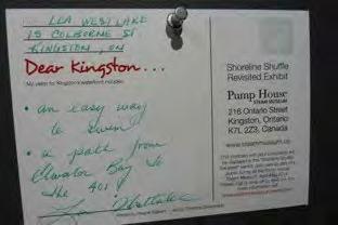
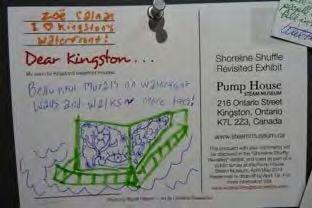
 3. design of key parcels 4. costing and phasing strategy 5.")
72 final master plan 1. detailed assessment of waterfront s existing conditions 2. land access strategy (connections and nodes) 3. design of key parcels 4. costing and phasing strategy 5. draft Official Plan policy amendments for consideration by all
73 Kingston s team City of Kingston Neal Unsworth Kris Hebert Cherie Mills Councillor Liz Schell Councillor Hutchison Community Mary Farrar Isabel Turner Laurel Claus-Johnson David McDonald Jamie Lemery Tech Agencies Rob McRae, CRCA David Gordon, SURP Viviane Paquin, KEAF Lorraine Farrar, MAAC Jennifer Hroch, KFLA
74 consulting team multi-disciplinary team: landscape architecture planning public engagement civil and environmental engineering shoreline engineering real estate property assessment real estate law
75 consulting team thinc design - lead / landscape architects Mehak, Kelly & Assoc. - stakeholder consultation McIntosh Perry - civil, brownfield, planning Shoreplan - shoreline inventory and assessment Rogers & Trainor - real estate Cunningham Swan - real estate law
76 team organization Milo Sturm Jane Graham Shoreplan Audrey Fung David Mugford thinc design Michael Tocher Peter Heyblom Mehak Kelly McIntosh Perry Mary Catherine Mehak Greg Newman Adam O Connor Mark Priddle Katie Brown Rogers & Trainor Gary Croke Cunningham, Swan David Munday Robert Tchegus
77 16 reaches, 280 KM of shoreline, one vision
78 Questions/ Comments on Process?
79 Activities 1. Post Card 2. Group Table Activity

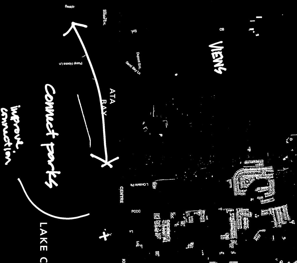
80 post card survey Dear Kingston...

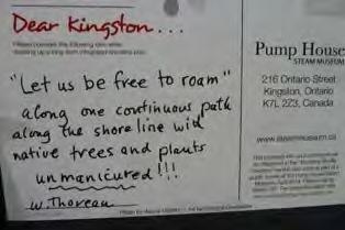
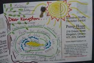
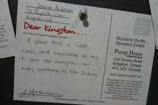
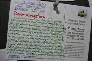
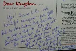
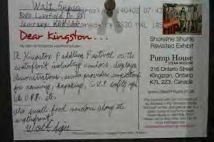
81 Dear Kingston responses


82 Dear Kingston My vision for Kingston s waterfront includes: Infrastructure Mentions/Comments - total 33 postcards - 90 mentions/comments on infrastructure identified and categorized pathways:!23%! water!access:!19%! acvvity!spaces/structures:! 15%! physical/natural! environment:!21%! art/interpretavon:!9%! amenives:!13%!


83 Dear Kingston My vision for Kingston s waterfront includes: Activity Mentions/Comments - total 33 postcards - 79 mentions/comments on activities identified and categorized Entertainment:"5%" Community"Building:"18%" EducaTon:"10%" Physical"AcTvity:"52%" Leisure:"15%"
84 post card survey 1. building on Dear Kingston postcard 2. identify priorities regarding access, connections and enhancements 3. also available online
85 table activity (30 min) coloured dots & markers: Yellow = access Green = connectivity Blue = enhancement Each person should identify where they would like to see improvements regarding access, connections and enhancements Add comments, lines, notes, etc. to convey any other information you feel should be shared
86 definitions Access: things (e.g., water, nature) activities (e.g., walking, cycling, fishing, swimming), experiences (e.g., social interaction, vistas, learning about heritage); to water at specific locations; for people with limited mobility
87 definitions Connectivity 1) in urban waterfront areas linkages to and along the waterfront to create full connectivity 2) in rural waterfront areas means places/ spaces to focus on for improvements, and connections to these from existing roadways, paths!
88 definitions Enhancement means tangible improvements to specific places/spaces!
89 access Use Yellow dots to identify places/spaces on the waterfront that you would like increased access to; use black pens to note the things that you would like to access at these places/spaces (e.g., relaxing, public art, swimming in Lake Ontario, heritage plaques/stories).
90 connectivity use green dots to identify points/places on the waterfront that you would like to see connected; use lines to connect the dots; use arrows to identify the direction of views or vistas that you would like to see; use black pens to note the end points of connections shown with dots, and the type of connection you would like to see (e.g., cycling path, roadway, unobstructed sightline).
91 enhancements use blue dots to identify places/spaces that you think require physical improvements; use black pens to note the names/locations of these places and the improvements you think are needed (e.g., more parking, clean up water, remove hazards for walking).

92 panels LOUGHBOROUGH LAKE COLLINS LAKE THE RIDEAU CANAL COLONEL BY LAKE LITTLE CATARAQUI CREEK THE C ATARAQUI RIVER COLLINS BAY W O DEADMAN BAY NAVY BAY L F E I S L A N D F E R R Y S HORSEY BAY C ATARAQUI BAY W O L F E I S LAN D F E RRY LAKE ONTARIO AND THE ST. LAWRENCE RIVER WOLFE ISLAND
93 panels L I T T L E C ATA R A Q U I C R E E K C O L L I N S B AY H O R S E Y B AY C ATA R A Q U I B AY L A K E O N TA R I O A N D T H E S T. L A W R E N C E R I V E R


94 EXAMPLE ONLY
95 table activity (30 min) coloured dots & markers: Yellow = access Green = connectivity Blue = enhancement Each person should identify where they would like to see improvements regarding access, connections and enhancements Add comments, lines, notes, etc. to convey any other information you feel should be shared
96 next steps 1. Collect and summarize input received 2. Site analysis over summer 3. Working Group Meeting (July 16th) 4. Public Meeting in late fall to present summary of background review
97 Questions/ Comments on Process?
98 Thank you for attending
KINGSTON S WATERFRONT MASTER PLAN
 KINGSTON S WATERFRONT MASTER PLAN Connections Access Enhancements Presented to the City of Kingston by thinc design Mehak, Kelly & Associates Inc. MacIntosh Perry Consulting Engineers Ltd. Shoreplan Engineering
Kingston Inner Harbour: A Cultural Heritage Landscape Pilot Study
 Kingston Inner Harbour: A Cultural Heritage Landscape Pilot Study Benjamin L. Holthof A report submitted to the School of Urban and Regional Planning in conformity with the requirements for the degree
LAKEVIEW VILLAGE VISION & MASTERPLAN PRESENTATION TO CITY OF MISSISSAUGA. April 9, 2018
 LAKEVIEW VILLAGE VISION & MASTERPLAN PRESENTATION TO CITY OF MISSISSAUGA April 9, 2018 AGENDA Introduction Vision Plan Comparison The Big Moves Trail Connections Plan Overview Districts Conveyance Comparison
Chairman and Members of the Planning and Development Committee. Thomas S. Mokrzycki, Commissioner of Planning and Building
 LA.09.TOR (Toronto) DATE: TO: FROM: SUBJECT: Chairman and Members of the Planning and Development Committee Thomas S. Mokrzycki, Commissioner of Planning and Building Central Waterfront Secondary Plan
City of Kingston. North King s Town Secondary Plan Open House + Workshop #1 February 28, 2018
 City of Kingston North King s Town Secondary Plan Open House + Workshop #1 February 28, 2018 1 event agenda 30 min Panel Review + Discussion 30 min Presentation + Q&A 75 min Workshop Session 15 min Report
Mississauga Waterfront. Parks Strategy - Draft
 Potential configuration for river s edge seating. Boating on Credit River: A regatta Boating on Credit River: Active enjoyment 5.2 Port Credit Memorial Park West Priority Park 5.2.1 Site Opportunities
PRELIMINARY DESIGN + DEVELOPMENT PLAN
 WELCOME! To The Public Open House May 30 th, 2017 HARBOUR WEST PARKS Vision Project Overview The City s vision for Port Credit Harbour West Parks is to develop a vibrant waterfront destination that integrates
Parks Master Plan Implementation: Phase I Waterfront Use and Design REPORT #: September 7, 2016 File #
 0 'O DI Lan-171-14 1 - THE CORPORATION OF THE TOWN OF COBOURG..,. STAFF REPORT TO: FROM: Mayor and Members of Council Dean A. Hustwick, Director of Recreation and Culture DATE OF MEETING: Committee of
Public Workshop 2 December 11, 2014 OLIN
 Public Workshop 2 December 11, 2014 OLIN TRIPLE IMAGE PANORAMA A NEW VISION FOR THE RIVERFRONT PROMENADE Burlington s Riverfront has historically been a defining character of the City s identity. This
Ashbridges Bay Erosion and Sediment Control Project
 Ashbridges Bay Erosion and Sediment Control Project Project Brief Overview Toronto and Region Conservation Authority, in partnership with the City of Toronto, intends to carry out remedial erosion control
Emerson Park Master Plan Update. Public Meeting III August 27, 2014
 Emerson Park Master Plan Update Public Meeting III August 27, 2014 Meeting Agenda: Project Update Presentation of Master Plan Components Discussion and Feedback The Path Forward: Building on the Concept
Table 8-4: Road Classification Local Roads, second table, of Chapter 8 Create a Multi-Modal City, be amended by adding the following:
 1 Port Street East Official Plan Amendment APPENDIX 3 Amendments to Mississauga Official Plan Table 8-4: Road Classification Local Roads, second table, of Chapter 8 Create a Multi-Modal City, be amended
BURTON STATION STRATEGIC GROWTH AREA PLAN UPDATE PUBLIC MEETING 3/26/18
 BURTON STATION STRATEGIC GROWTH AREA PLAN UPDATE PUBLIC MEETING 3/26/18 1 WHERE WE ARE? 2 PRIMARY OBJECTIVES OF THE PLAN UPDATE 1. Update the land use designation for Burton Station Village to reflect
Please read the entire document
 projects impacting the waterfront revitalization area. The waterfront revitalization area of the town will have to subareas to the west and east of the village. Page 6 of 6 Wayfinding master plan create
Nepean Point CONSULTATION REPORT JUNE 2014
 Nepean Point CONSULTATION REPORT JUNE 2014 Workshop: Nepean Point I Project description Objective: With the renewal of Nepean Point, the National Capital Commission (NCC) presented a project to develop
{Best Practices. Summary of Tools, Strategies and Best Practices from 11 Michigan Case Study Communities
 Case Studies Michigan Coastal Community Working Waterfronts { Summary of Tools, Strategies and from 11 Michigan Case Study Communities Table of Contents Zoning...2 Community and Stakeholder Collaboration
Port of Camas-Washougal Waterfront Trail Master Plan
 Port of Camas-Washougal Waterfront Trail Master Plan The Port s facilities are the products of its mission: To make strategic investments that enhance the community s quality of life by bringing jobs,
Project purpose. advise. The purpose of the Beaumaris Lake Open Space Rehabilitation project is to: + Develop a Functional Program Concept
 Project purpose owns Road Beaumaris Road The purpose of the Beaumaris Lake Open Space Rehabilitation project is to: + Develop a Functional Program Concept + Guide Rehabilitation of Landscape and Community
The following principles guide the development of goals and strategies to protect and promote these amenities:
 OPEN SPACE/PARKS/TRAILS/RECREATION GOALS/STRATEGIES Cherry Hills Village is a living environment that offers low density development, open areas, public scenic vistas, public trails and public parks. This
10.0 Open Space and Public Realm
 10.0 Open Space and Public Realm 10.0 Open Space and Public Realm The Public Open Space System is comprised of: outdoor spaces available for public use that are either publicly owned (e.g., parks and
The Planning Partnership Baird + Associates TCI Management Consultants Ltd. Plan B Natural Heritage Wills Consulting Engineers Poulos & Chung Limited
 Little Lake Master Plan The Planning Partnership Baird + Associates TCI Management Consultants Ltd. Plan B Natural Heritage Wills Consulting Engineers Poulos & Chung Limited May 26, 2009 Purpose of Study
Central Lake Ontario Conservation Conservation Lands Master Plan
 Conservation Lands Master Plan Top 13 Frequently Asked Questions 1. What are conservation lands? Where are these conservation lands located in the Central Lake Ontario Conservation watershed? Conservation
PUBLIC SPACE/AMENITY PROJECTS
 BUFFALO S LWRP 49 A1. Black Rock Canal Park Improvements Erie County Parks Black Rock Canal Park, Ontario and Niagara Street intersection PROJECT DESCRIPTION: Erie County s Black Rock Canal Park is 4.25
Lynn Waterfront Master Plan
 Lynn Waterfront Master Plan Public Meeting #2 December 10th, 2018 1 Project Schedule Update September 26, 2018 December 10, 2018 Development of the Master Harbor Plan Amendment and Revised Waterfront Master
Highest & Best Use Study Marina Park Lands
 Executive Summary of Report MARCH 2006 TABLE OF CONTENTS 1. Introduction...1 2. Study Process...2 3. Highest And Best Use Program...3 4. Concept Plan...8 5. Public Area Animation...9 6. Marina Park Implementation
Community Conversation. Thursday, March 30, James St N 7:00 pm 9:15 pm
 Community Conversation Thursday, March 30, 2017 294 James St N 7:00 pm 9:15 pm Start Time Agenda item Presenter / Facilitator 7:00 Welcome & Agenda Overview Diedre Rozema (City of Hamilton) Participation
Public Workshop #2 October , Welcome. Former Kingston Penitentiary & Portsmouth Olympic Harbour
 Public Workshop #2 October 12 + 13, 2016 Welcome Former Kingston Penitentiary & Portsmouth Olympic Harbour Cataraqui Golf and Country Club Portsmouth Avenue St. Lawrence College Sir John A. Macdonald Blvd
North Shore Trail. Council Meeting June 10, 2002
 North Shore Trail Council Meeting June 10, 2002 Process Guiding Principles Inventory and Analysis Preliminary Concepts (4) Final Concept Phasing Strategy Estimated Costs OVERVIEW Purpose: Prepare an overall
Highland Falls Waterfront Redevelopment Feasibility Study Village Board Meeting March 20, 2017
 Village Board Meeting March 20, 2017 Agenda I. Public Meeting #1 Visioning Summary II. Public Meeting #2 Comment Summary III. IV. IV. Case Study: Milton Train Station Schematic Design Concepts Schedule/Next
TOWN COUNCIL / PLANNING COMMISSION
 Workshop #3 TOWN COUNCIL / PLANNING COMMISSION January 20, 2011 Consultant Team In Attendance Tonight BMS Design Group Nevada City and San Francisco Michael Smiley, AICP, ASLA Partner-in-Charge Nancy L.
Inspiration Port Credit. Exploring the Options Public Engagement March 26, 2013
 Inspiration Port Credit Exploring the Options Public Engagement March 26, 2013 Port Credit Port Credit Foundations Change has been happening in Port Credit for years. Source: City of Mississauga, Mississauga
Welcome. Tannery and Waterworks Parks Shoreline Improvements Environmental Assessment. Public Information Centre #1 November 27, pm to 8 pm
 Welcome Tannery and Waterworks Parks Shoreline Improvements, Environmental Assessment Tannery and Waterworks Parks Shoreline Improvements Environmental Assessment #1 6 pm to 8 pm Why We Are Here Tannery
Fort Wellington National Historic Site
 Fort Wellington National Historic Site DECEMBER 2015 PUBLIC CONSULTATION DOCUMENT Invitation to participate Fort Wellington National Historic Site has begun the process of reviewing its management plan.
The Plan for Port Whitby
 The Plan for Port Whitby December 5, 2012 Community Meeting Summary Report Prepared by GLPi January 17, 2013 1 Introduction The purpose of the Port Whitby Secondary Plan Update, Community Improvement Plan
Town Centre Park. Delahaye. David Avenue. Pine wood. Pipeline Rd. Pinetree. Town Ctr Blvd. Guildford. Guildford. High St. Westwood. Pinetree.
 WELCOME This open house is to give you an opportunity to review the proposed design of an outdoor performance and events plaza at Town Centre ark and to share your ideas, suggestions and thoughts related
APPENDIX K WINDSOR OFFICIAL PLAN
 CEAA ENVIRONMENTAL ENVIRONMENTAL IMPACT ASSESSMENT AMBASSADOR BRIDGE ENHANCEMENT PROJECT Replacement Span and Plaza Expansion APPENDIX K WINDSOR OFFICIAL PLAN Avalon Consulting Professionals of Ontario,
HBF Marine Study: Victoria Harbour: Water dependent and water related uses and associated land/water interface implications
 HBF Marine Study: Victoria Harbour: Water dependent and water related uses and associated land/water interface implications Presentation on the Initial Findings 9 February 2011 Harbour Business Forum Background
Planning Commission March 14, Presented by: City of Bellingham Port of Bellingham
 Planning Commission March 14, 2013 Presented by: City of Bellingham Port of Bellingham 1 Agenda Waterfront District Background Waterfront District Proposal Overview Sub-area Plan Development Regulations
Waterfront Development Master Plan
 PORT of VANCOUVER USA Vancouver, WA Waterfront Development Master Plan DRAFT - FINAL CONCEPTUAL MASTER PLAN PROJECT TEAM NBBJ Heritage Research Associates JLA Kittelson Associates Leland Consulting Group
Public Meeting #3 May 9, 2009 MVVA Team
 Public Meeting #3 May 9, 2009 MVVA Team Welcome to the third Public Meeting for the Lower Don Lands Municipal Class Environmental Assessment (EA) Infrastructure Master Plan and Keating Channel Precinct
Purpose of Open House #3
 Public Meeting #3 May 9, 2009 MVVA Team Purpose of Open House #3 The main purpose of this Open House is to present and seek input on the: Evaluation of transportation and infrastructure design alternatives
1 Port Street East: Delivering on the Vision. Andrew Whittemore Director, City Planning Strategies. Ruth Marland. TOPCA May 23, 2017
 1 Port Street East: Delivering on the Vision Andrew Whittemore Director, City Planning Strategies Ruth Marland TOPCA May 23, 2017 Strategic Leader, City Planning Strategies Mary Ellen Bench City Solicitor
APPENDIX L3. Table of Contents. SWP EA Information Sheets
 E N V I R O N M E N T A L A S S E S S M E N T APPENDIX L3 SWP EA Information Sheets Table of Contents EA Info Sheet 1... L3-1 EA Info Sheet 2... L3-3 EA Info Sheet 3... L3-5 EA Info Sheet 4... L3-7 SCARBOROUGH
BRADENTON RIVERWALK EXPANSION MASTER PLAN
 BRADENTON RIVERWALK EXPANSION MASTER PLAN INTRODUCTION & AGENDA Process Update Community Engagement Summary Center for Active Design (CfAD) Recommendations Context and Existing Conditions Master Plan Alternatives
Bristol Marsh Heritage Conservancy
 Bristol Marsh Heritage Conservancy The Pennsylvania Environmental Council (PEC) protects and restores the natural and built environments through innovation, collaboration, education and advocacy. PEC believes
Chapter 6. Overall Vision RECOMMENDATIONS. More Trail and Trail. Connections. Equal Access to Park. Facilities and Programs. Water Access.
 Overall Vision More Trail and Trail Connections Equal Access to Park Facilities and Programs Water Access Environment Variety Chapter 6 RECOMMENDATIONS Chapter 6 The following recommendations for park,
A BLUEPRINT FOR BROCKTON A CITY-WIDE COMPREHENSIVE PLAN
 A BLUEPRINT FOR BROCKTON A CITY-WIDE COMPREHENSIVE PLAN Public Meeting October 2016 1 Plan Summary and Discussion Public Meeting May 4 2017 City of Brockton Bill Carpenter, Mayor Department of Planning
THE CORPORATION OF THE TOWN OF ST. MARYS
 THE CORPORATION OF THE TOWN OF ST. MARYS DISCUSSION PAPER #8 (update) RECREATION AND PARKLAND - DRAFT - Presented to the Town of St. Marys Planning Advisory Committee on December 18, 2017 Introduction
T O W N O F H I G H R I V E R
 T O W N O F H I G H R I V E R o p e n s p a c e p l a n The Town of High River, 30 minutes South of Calgary, still retains much of its distinctive small town character and provides residents with a high
Sub-committee on Harbour Plan Review of Harbour-front Enhancement Committee. Ninth Meeting
 Sub-committee on Harbour Plan Review of Harbour-front Enhancement Committee Ninth Meeting Date: 5 October 2005 Time: 3:30pm Venue: Conference Room 15/F, North Point Government Offices, 333 Java Road, North
Sustainability, Health, Safety, Recreation & Open Space Working Group August 3, 2017
 Sustainability, Health, Safety, Recreation & Open Space Working Group August 3, 2017 DOWNTOWN OAKLAND SPECIFIC PLAN WELCOME Sustainability, Health, Safety, Recreation & Open Space Working Group Social
ARISE: The Rock Renaissance Area Redevelopment & Implementation Strategy
 2014 Professional Awards 1 ARISE: The Rock Renaissance Area Redevelopment & Implementation Strategy Janesville, WI Completed December 2014 Analysis & Planning Purpose of Project 2 The purpose of the Rock
Scarborough Waterfront Project
 Scarborough Waterfront Project Public Information Centre #1 Environmental Assessment Terms of Reference September 10, 2014 Agenda Open House Presentation 7:00 to 7:30 pm Presentation 7:30 to 8:15 pm History
Goals and Action Items
 Goals and Action Items Developing goals and action items is an important part of the recreation planning process. The overall goals of a recreation department are to provide recreation opportunities for
12 th Street Connector Alignment Study VISIONING PUBLIC WORKSHOP - JUNE 25, :00PM TO 8:00PM
 12 th Street Connector Alignment Study VISIONING PUBLIC WORKSHOP - JUNE 25, 2018 6:00PM TO 8:00PM Goals for Today s Workshop Agenda: Project Introduction, Purpose, and Goals Existing Conditions Traffic
JACKsON STREET PIER CONCEPTUAL DESIGN PACKAGE SEPTEMBER 21, 2017
 JACKsON STREET PIER CONCEPTUAL DESIGN PACKAGE SEPTEMBER 21, 2017 JACKsON STREET PIER Process outline DESIGN PROCESS OVERVIEW: Sandusky s Jackson Street Pier Conceptual Design process included input from
Albion Hills Conservation Area Master Plan. Public Information Session
 Albion Hills Conservation Area Master Plan Public Information Session 1 03.25.2014 Meeting Agenda 1. Project Introduction Property History Current Use Master Plan Process 2. Draft Vision Goals and Objectives
The West Vaughan Employment Area Secondary Plan Policies
 Part 2: The West Vaughan Employment Area Secondary Plan Policies 2.1 General Policies It is the policy of Council: 2.1.1. That the West Vaughan Employment Area (the WVEA), identified on Schedule 1, will
K+P TRAIL EXTENSION FEASIBILITY STUDY PRELIMINARY SITE ANALYSIS PLAN PREPARED FOR THE CITY OF KINGSTON NOT FOR CONSTRUCTION
 YY/MM/DD V:\2015\1415605-000 - Kingston K+P Trail Extension Feasibility\Drawings\K+P - Sheet Layout.dwg TITLEBLOCK: 790mm x 534mm OTTAWA LA 2014 PRELIMINARY SITE ANALYSIS PLAN PREPARED FOR THE NOT FOR
Toronto Parks Renaissance Strategy
 Toronto Parks Renaissance Strategy Overview, Emerging Themes and Directions Presentation to EDPC, May 4, 2006 Parks Renaissance Strategy Presentation Agenda Project Overview Emerging Themes and Directions
Lakeview and Port Credit District Policies Review Public Engagement Process
 Lakeview and Port Credit District Policies Review Public Engagement Process Brook McIlroy Planning + Urban Design/PACE Architects MSAi Architects Poulos and Chung Transportation Engineers December 11,
Bloor Street East Potential Ravine Portal Overlook and Access Passage to the Rosedale Valley and Don River Valley Ravine, Toronto, Canada
 TRANSFORMATIVE IDEA 2. GREAT STREETS Bloor Street Christie Pits Park Bloor St Spadina Ave Bathurst St Shaw St 1 Recognize the significant public realm improvements along Bloor Street and extend and enhance
Strategies/Actions Priority List
 Strengthening the Creative Sector: Build stronger relationships with, and between, cultural organizations and businesses and increase opportunities for working together to build capacity within organizations.
TOWN OF BETHLEHEM MEETING SUMMARY LOCAL WATERFRONT REVITALIZATION PROGRAM UPDATE
 TOWN OF BETHLEHEM LOCAL WATERFRONT REVITALIZATION PROGRAM UPDATE MEETING SUMMARY Purpose: LWRP Update Public Workshop #3 Date and Time: October 24, 2017, 6:00 pm - 8:00 pm Location: Town Hall, 445 Delaware
Introduction. Chapter 1. Purpose of the Comprehensive Plan Plan Organization Planning Process & Community Input 1-1
 Chapter 1 Introduction Lakewood 2025: Moving Forward Together Purpose of the Comprehensive Plan Plan Organization Planning Process & Community Input 1-1 Purpose of the Comprehensive Plan The Comprehensive
burlington mobility hubs study Downtown Burlington Mobility Hub
 burlington mobility hubs study Downtown Burlington Mobility Hub Draft Precinct Plan Workbook PIC #3, September 7, 2017 downtown mobility hub objectives City staff and their consultants are proposing an
Waverley West B Secondary Planning Process. Open House South Pointe School April 25, 2018
 averley est B Secondary Planning Process South Pointe School April 25, 2018 averley est B Secondary planning process open house Please review the boards and provide your feedback. 1 The Role of a Secondary
The Master Plan Framework
 The Master Plan Framework The East Harbour Master Plan advances the development of 60 acres of former industrial lands east of the Don River. The Master Plan outlines a vision for a vibrant, transit-oriented
Thank you for coming to the Rail Corridor Land Use Study Public Meeting.
 01 Welcome! Thank you for coming to the Rail Corridor Land Use Study Public Meeting. Tonight is an opportunity to learn about the Land Use Study for the Rail Corridor Site. In Fall 2016, Toronto City Council
M i s s i o n B a y W a t e r f r o n t
 114 M i s s i o n B a y W a t e r f r o n t Character of the Area: The Mission Bay Waterfront extends from Pier 48 at China Basin Channel to 18th Street in the Central Basin. This area of the waterfront
Village of Fair Haven Goals & Objectives
 Village of Fair Haven Goals & Objectives 1 Natural Environmental Quality & Aesthetics Embrace policies and programs that preserve and enhance the Village s natural resources, environment, water quality,
CATARAQUI RIVER THIRD CROSSING EA Landscape Analysis Background Report. October 23, Corush Sunderland Wright Limited
 October 23, 2009 Corush Sunderland Wright Limited INTRODUCTION The City of Kingston has initiated an Environmental Assessment (EA) to assess the need for, and the feasibility of, implementing additional
WELCOME TO OPEN HOUSE TWO November 28, 2018
 Langstaff Road Weston Road to Highway 7 Class Environmental Assessment Study WELCOME TO OPEN HOUSE TWO November 28, 2018 Please sign in and join our mailing list Study Overview York Region is conducting
ASHTABULA COUNTY COASTAL MANAGEMENT PLAN
 Location Ashtabula County, Ohio Planning Grantwriting ODNR, Office of Coastal Management, $25,000 Local Match $25,000 Size 21 miles of coastal area Professional Services 2012 Project Team Randy Mielnik,
Kick-off Meeting,: September 11, 2014
 Town of Midland Downtown Master Plan Study Kick-off Meeting,: September 11, 2014 PRESENTATION OVERVIEW 1. Trip Agenda 2. Introduction 3. Work Program & Schedule Consultation Strategy Project Phases and
Town Centre Park Master Plan Update - Terms of Reference
 CoQuitlam For Committee Our File: 12-6100-20/14-001/1 Doc#: 2176441.V7 To: From: Subject: For: City Manager General Manager Parks, Recreation & Culture Services Town Centre Park Master Plan Update - Terms
LPC Goals and Strategies. Transportation and Connectivity Employment Opportunities Food Access Waterfront Access Livable Communities
 LPC Goals and Transportation and Connectivity Employment Opportunities Food Access Waterfront Access Livable Communities Transportation and Connectivity Goal: Safe and ready access of all types allowing
Chair and Members of the Planning, Public Works and Transportation Committee. Tara Buonpensiero, Senior Planner Policy, MCIP, RPP
 REPORT TO: REPORT FROM: Chair and Members of the Planning, Public Works and Transportation Committee Tara Buonpensiero, Senior Planner Policy, MCIP, RPP DATE: April 9, 2018 REPORT NO.: RE: PLS-2018-0027
City of Toronto. Emery Village Transportation Master Plan
 City of Toronto Emery Village Transportation Master Plan May 2009 Emery Village Transportation Master Plan Toronto, ON May 2009 Consulting Inc. 100 York Blvd., Suite 300 Richmond Hill, ON L4B 1J8 Tel:
planning toronto s downtown Parks and Public Realm Plan Request for Proposals Information Meeting Andrew Farncombe, Project Manager August 19, 2015
 planning toronto s downtown Parks and Public Realm Plan Request for Proposals Information Meeting Andrew Farncombe, Project Manager August 19, 2015 BATHURST ST Keeping Downtown a great place to live, work,
Welcome. Community Consultation Meeting November 28, Review and discuss the Bathurst Quay Neighbourhood Plan Framework
 Welcome Community Consultation Meeting November 28, 2016 Why Are We Here Today? Review and discuss the Bathurst Quay Neighbourhood Plan Framework Review and discuss an Action Plan for Implementation Next
Bridgeport Comprehensive Waterfront Plan 2 nd Launch Neighborhood Meeting 3/9/16
 CivicMoxie 2016 #WaterfrontBPT @CivicMoxie Bridgeport Comprehensive Waterfront Plan 2 nd Launch Neighborhood Meeting 3/9/16 City of Bridgeport OPED, Department of Planning Bridgeport s greatest asset is
Burnside Gorge Neighbourhood Plan. Engagement Summary
 Burnside Gorge Neighbourhood Plan Engagement Summary Table of Contents Engagement Summary... 3 Phase One Engagement (April May 2015)... 4 Phase Two Engagement (January March 2016)... 4 Appendix One: Summary
STUDY AREA. Tonight s Agenda. Project Tasks Completed. Next Steps. Town of Oyster Bay Eastern Waterfront Community Vision & Revitalization Plan
 Town of Oyster Bay Eastern Waterfront Community Vision & Revitalization Plan Public Meeting January 27, 2009 Opening Remarks Presentation Tonight s Agenda Introduction Study Area Overview Public Participation
5.0 P A R K R E C O M M E N D A T I O N S
 5.0 P A R K R E C O M M E N D A T I O N S 5.1 Confederation Park The analysis of Confederation Park recognizes that it, along with City Hall, is the symbolic heart of Kingston. While the existing layout
edmonton.ca/ribbonofgreen #ribbonofgreen
 WHAT IS THE RIBBON OF GREEN? The Ribbon of Green is Edmonton s entire river valley and ravine system. The Ribbon of Green (2018) Project will provide strategic guidance for the southwest and northeast
Downtown Streetscape Manual & Built Form Standards
 City of Guelph Downtown Streetscape Manual & Built Form Standards July 2014 Prepared by Brook McIlroy Inc. in association with Unterman McPhail Associates and McCormick Rankin Inc. City of Guelph Downtown
Report to: Development Services Committee Report Date: April 24, 2017
 SUBJECT: Cornell Rouge National Urban Park Gateway - Report on Design Charrette and Next Steps PREPARED BY: Lilli Duoba, MES, MCIP, RPP, Manager, Natural Heritage (ext. 7925) REVIEWED BY: Marg Wouters,
DOWNTOWN PARKS & PUBLIC REALM PLAN
 DOWNTOWN PARKS & PUBLIC REALM PLAN CHALLENGES The Parks and Public Realm Strategy addresses challenges associated with a growing Downtown, including: GOALS 3.3 New buildings will fit within their existing
City Center Neighborhood Plan
 [1] City Center Neighborhood Plan As adopted by Ordinance No. 2014-09-049 and amended by Ordinance Nos. Formerly CBD Neighborhood as adopted by Ordinance No. 8868 and amended by Ordinance Nos. 8946, 9693,
Cold Lake Marina Master Plan
 Cold Lake Marina Master Plan Intro to Team Moffatt & Nichol is recognized throughout the world for our role in the revitalization and redevelopment of urban waterfronts, including the evolution of modern
HURON WATERFRONT DEVELOPMENT AND AMPHITHEATER
 AWARD WINNING PROJECT Location Huron, Ohio Architectural, Engineering, Site, Landscaping, Planning, Survey, Grant Administration, Construction Administration Cost $285,000 Amphitheater $300,000 Marina
Albion Hills Conservation Area Master Plan: Project Summary
 Albion Hills Conservation Area Master Plan- Project Summary December 9, 2014 Albion Hills Conservation Area Master Plan- Project Summary December 9, 2014 Albion Hills Conservation Area Master Plan: Project
DOMINION BOULEVARD CORRIDOR STUDY AND ECONOMIC DEVELOPMENT STRATEGIC PLAN A MODEL FOR CHESAPEAKE S FUTURE
 DOMINION BOULEVARD CORRIDOR STUDY AND ECONOMIC DEVELOPMENT STRATEGIC PLAN A MODEL FOR CHESAPEAKE S FUTURE Overview I. Draft Plan Process II. Draft Plan Overview a. Market Analysis b. Master Land Use Plan
Preliminary Market Analysis
 Preliminary Market Analysis The preliminary market analysis is used to inform the Vision and opportunities to be explored in the next phase of the secondary plan. It will continue to guide strategies to
Animating the Rideau Canal December 2013
 Executive Summary Animating the Rideau Canal December 2013 Why study the Rideau Canal? The Rideau Canal has been an important part of Ottawa throughout its history, and has shaped and been shaped by the
PORT WHITBY COMMUNITY
 PORT WHITBY COMMUNITY SECONDARY PLAN UPDATE COMMUNITY IMPROVEMENT PLAN URBAN DESIGN GUIDELINES September 2015 DRAFT PROPOSED AMENDMENT NUMBER # to the Whitby Official Plan PURPOSE: The intent of this Amendment
Public Open House. Overview of the Downtown Plan Official Plan Amendment April 23, 2018
 Public Open House Overview of the Downtown Plan Official Plan Amendment April 23, 2018 1 A 25-Year Plan for Downtown To ensure growth contributes positively to Toronto s Downtown as a great place to live,
Streets for People, Place-Making and Prosperity. #TOcompletestreets
 COMPLETE STREETS FOR TORONTO Streets for People, Place-Making and Prosperity COMPLETE STREETS: A NEW APPROACH A Complete Streets design approach considers the needs of all users people who walk, bicycle,
Mendota Heights 2040 Comprehensive Plan Draft Vers
 4 Parks and Trails The City of Mendota Heights boasts a variety of recreational and open space opportunities. Few cities can claim access to regional trails, riverside and lakeside parks, scenic bluffs