City of Eugene Stormwater Tour
|
|
|
- Berenice Jennings
- 6 years ago
- Views:
Transcription


 The Polk Street Water Quality Improvment Vault Irving Rd. Kalmia St.")


 Drywell Elimination Program Shirley Area 4) Drywell Elimination Program Willowbrook Area Marist High School")

1 Berntzen Rd. Baxter St. Hyacinth St. Bushnell Ln. Bonvue N. Park Ave. Park Ave. Horn Ln. Lake Dr. Fairway Dr. Ross Ln.. N. Jackson Dr. Ferndale Dr. Dalton Dr. Andersen Ave. Pamell St. Banner St. Manazana St. Manazana Evergreen Dr. Willagillespie Rd. City of Eugene Stormwater Tour Korbel St. Arrowhead St. Lancaster Dr. ARROWHEAD Irvington Dr. 4 Barstow Ave. Spring Creek Lodenquai Ln. Blackfoot Ave. Anchor Ave. TERRA LINDA River Loop 1 Wilkes Dr. River Loop 1 Madison Middle School River Loop 1 WHITELY LANDING (Lane County) *) 1820 Roosevelt Blvd. Alderbrook Ln. Irving School Greenfield Ave. FERNDALE 3 River Loop 1 1) The Polk Street Water Quality Improvment Vault Irving Rd. Kalmia St. Irving Rd. Santa Clara Green Ln. Lone Oak Lp. 2) The Heron Slough Restoration Project MANGAN PETERSEN BARN & Kenmore Taney St. Malabon Prairie Road Maxwell Rd. Hawthorne Ave. Smithoak St. Elmira Rd. Anthony Bramb Bushnell Ln. lewood BRAMBLEWOOD Fairfield Bell Ave. Wood Ave. Beltline Highway WALNUT GROVE Fairfield Ave. Labona Dr. Compton LARK Skipper Ave. Bethel N. Park Ave. Bennett Ln. Gilbert St. Coraly Ave. Colin Kelly Middle School Hatton Ave. Barrett Ave. Nantucket Ave. EMERALD (River Road Park & Recreation District) TRAINSONG GILBERT Maple St. Figueroa St. Seneca Rd. Ruby Ave. RUBY Emerald Park Dr. Northwest Expressway Southern Pacific Railroad Santa Clara Ave. Howard Bell St. Corridor Beebe Ln. Edison St. Silver Ln. Howard Ave. Bethel Dr. North Eugene High School Barton Dr. Harvey Ave. River Rd. Maynard Ave. 2 ROSETTA PLACE Benjamin St. Horn Ln. Lone Oak Way Rosetta Ave. Owosso Dr. Hilliard Ln. Elkay Dr. LONE OAK River Ave. E. Howard Ave. Melvina Way Merry Ln. River Road Roosevelt Blvd. * Copping St. OWOSSO PED/BIKE BRIDGE W i l l a m e t te R i v e r WEST BANK Crest Dr. Lone Oak Ave. River Road Park Annex River Rd. Division Ave. Stults Ave. RASOR Rasor MAURIE JACOBS Chambers St. Beaver St. Kingsley Rd. EAST BANK 3) Drywell Elimination Program Shirley Area 4) Drywell Elimination Program Willowbrook Area Marist High School GREENWAY PED/BIKE BRIDGE Railroad Blvd. Cross 1 N. Polk St. Goodpasture Lakes Lp. Delta Ponds Goodpasture Island Rd. SLADDEN N. Grand St. Cedar St. N. Adams St. Clark St. Delta Hwy. Valley River Dr. Valley River Way Russet Dr. OWEN ROSE GARDEN 1st Ave. (Permit required for bikes) Happy Ln. Fir Acres Dr. Rio Glen Dr. Clinton Dr. Washington/Jefferson Bridge Green Acres Rd. Willagillespie Wi l l a met t e River RIVER PLAY SKINNER BUTTE Wallis St. 5th Ave. SCOBERT GARDENS Blair Blv 2nd Ave. WASHINGTON JEFFERSON 5th Ave.

2 Polk Street Outfall Project at a Glance 2008 Construction o Multi-year Planning Process Upstream from Willamette River o High Visibility 770 Acre Basin Cleaned 3x Year PW Maintenance Staff $ 1.14 Million Removes Sediment, Oil, Grease, & Trash Storm Outfall can be by-passed to Sanitary Sewer for spill response


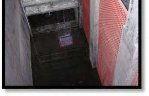


3 Oil Baffle Trash Rack Slide Gates Weir Structure Construction Sediment Chamber Routine Maintenance Post Construction
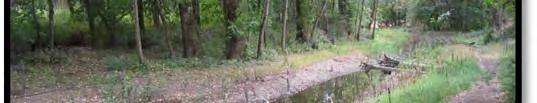
4 Heron Slough Project at a Glance Construction Backwater habitat for juvenile Chinook Salmon Willamette River flow-through (+8000 cfs) Multiple Funding Sources and Construction Phases o ACOE, NOAA, City of Eugene Part of Larger 10+ Yr. Delta Ponds Restoration/Enhancement o See Included Delta Ponds Project Map


5
 Invasive Species Control and Riparian Planting (2009-2011) Parking Lot")
 Shared-Use Path (2003) Parking Lot Culvert to Allow Flow Under Road (2010) Bridge")
 Gated Culvert to Regulate Flow (August 2007) Shared-Use Path (2003) R Delta Ponds")
 Parking Lot Pedestrian Trail Planned Pedestrian Trail Bridges (existing or planned) Interpretive Signage")
6 January 2014 Aerial Photo Base: Summer 2009 Side Channel Constructed (2010) Shared-Use Path (2003) Bicycle-Pedestrian Bridge (2010) Heron Slough Side Channel Constructed Bicycle-Pedestrian Bridge (2012) Invasive Species Control and Riparian Planting ( ) Parking Lot (2005) Boardwalk Trail (2008) (2005) R Boardwalk Invasive Species Control and Riparian Planting ( ) Trail Bridge Bridge Trail Invasive Species Control and Riparian Planting ( ) Shared-Use Path (2003) Parking Lot Culvert to Allow Flow Under Road (2010) Bridge Bridge Invasive Species Control and Riparian Planting ( ) Shared-Use Bridge and Path (2010) Completed or Planned Enhancements Weir Installed to Allow High Water Flow into Ponds (2005) Gated Culvert to Regulate Flow (August 2007) Shared-Use Path (2003) R Delta Ponds Project Boundary Weir (inlet to ponds from river) Gated Culvert Culvert Excavated Channel (to improve flow within ponds) Riparian Bench (contoured and planted ) Parking Lot Pedestrian Trail Planned Pedestrian Trail Bridges (existing or planned) Interpretive Signage Direction of Water Flow Restroom
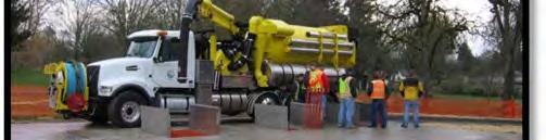
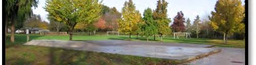
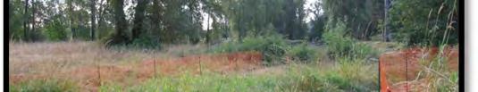
7 Drywell Elimination Program Shirley Area Project at a Glance 2012 Construction 16 Drywells Catchment Area 30 Acres Ferndale Park Swale (0.30 acres) New Collection System (4800 pipe) Overflow to existing Lane County system (Spring Creek) $1 million Oregon APWA Environmental Project of the Year 2013


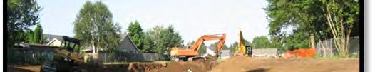


8 June 2012 September 2012 November 2012 May 2013 Sept 2013 April 2014
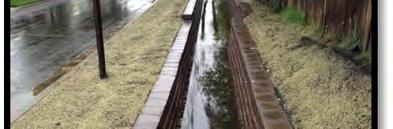
9 Drywell Elimination Program Willowbrook Area Project at a Glance 2013 Construction 7 Drywells Catchment Area 13 Acres Willowbrook Swale (City of Eugene ROW) New Collection System (1370 pipe) Overflow to existing Lane County system (Irvington Rd) $500,000 History of Neighborhood Flooding


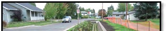


10 Neighborhood Flooding April 2013 July 2013 September 2013 September 2013 March 2014
Potential Green Infrastructure Strategies May 6, 2015 Workshop
 Potential Green Infrastructure Strategies May 6, 2015 Workshop Background The City of Cortland is developing the Tioughnioga Urban Headwaters Green Infrastructure Action Plan with funding from the National
Stormwater Regulations & Considerations Morse Study Area. Pam Fortun, P.E. CFM Senior Stormwater Treatment Engineer Engineering Services Division
 Stormwater Regulations & Considerations Morse Study Area Pam Fortun, P.E. CFM Senior Stormwater Treatment Engineer Engineering Services Division Stormwater Regulations Development Considerations Floodplain
Reconnecting to a Forgotten River St. Cloud MN. Aaron Hanson Design Design Thesis LA 572, Thesis, Spring 2012
 Reconnecting to a Forgotten River St. Cloud MN Aaron Hanson Design Design Thesis LA 572, Thesis, Spring 2012 site context 2.5 Miles Sartell St. Cloud to Fargo 170 Miles (2 hrs 45 mins) Hwy 10 infrastructure
STAFFORD TRACT NORTH OF US90A 1.0 INTRODUCTION 1.1 OBJECTIVE
 1.0 INTRODUCTION 1.1 OBJECTIVE This report, prepared for submittal to TxDOT, analyzes existing and proposed detention facilities draining into the TxDOT US90A storm sewer system. The results of the detailed
MILLS PARK & PANTHER CREEK GREENWAY
 , North Carolina August 19th, 2014 Introduction, North Carolina Why are we here? Planning Investment to Date - Park, North Carolina 2012 Parks, Recreation, and Cultural Resources Master Plan Planning Investment
ADOPTED CAPITAL IMPROVEMENT PROGRAM BUDGET ARROYO PROJECTS
 ADOPTED CAPITAL IMPROVEMENT PROGRAM BUDGET ARROYO PROJECTS HAHAMONGNA FY 212-216 Capital Improvement Program Priority Description Total Estimated Costs Appropriated Through FY 211 Adopted FY 212 FY 213
Rouge River Gateway Master Plan Update: 2011
 Rouge River Gateway Master Plan Update: 2011 Environmental Stewardship Cultural Heritage Recreation Economic Development Rouge Gateway Master Plan (2001) 1 Rouge Gateway Master Plan Update (2005) Significant
Urban runoff in my neighborhood (Capitol Hill) is heavy with trash and other debris.
 is heavy with trash and other debris.") South Platte River Meeting Comments & s #1 I am a huge fan of river areas and would love the Platte and surrounding waterways to improve to allow habitat for wildlife and recreation opportunities for citizens.
South Platte River Meeting Comments & s #1 I am a huge fan of river areas and would love the Platte and surrounding waterways to improve to allow habitat for wildlife and recreation opportunities for citizens.
FY Capital Improvement Program Arroyo Projects
 FY 219-223 Capital Improvement Program FY 218 FY 219 FY 22 FY 221 FY 222 FY 223 1 2 3 4 5 6 7 8 9 1 Hahamongna - Implement Master Plan - Oak Grove Area Improvements (7756) Hahamongna - Implement Master
Stormwater Retrofits Made Practical City of Eugene Oregon. Doug Singer, P.E., CSM Principal Civil Engineer City of Eugene Public Works
 Stormwater Retrofits Made Practical City of Eugene Oregon Doug Singer, P.E., CSM Principal Civil Engineer City of Eugene Public Works Doug Singer Introduction BS Civil Engineering from Oregon State University
WILLAMETTE FALLS LEGACY PROJECT
 OPPORTUNITIES & CONSTRAINTS There are here three falls on a line of rocks extending across the river, which forms the bed of the upper channel. The water is precipitated through deep abrazed gorges, and
REQUEST FOR COUNCIL ACTION 6A AGENDA ITEM ORIGINATING DEPT. AGENDA ITEM CITY ADMINISTRATOR APPROVAL
 DATE REQUEST FOR COUNCIL ACTION 6A AGENDA ITEM ORIGINATING DEPT. AGENDA ITEM CITY ADMINISTRATOR APPROVAL Community Development Territorial Greens PUD Concept Plan Development Stage Plan Subdivision (Preliminary
Santa Cruz River Master Plan. Presented to the Arizona Floodplain Management Association Spring Conference June 8-10, 2011
 Santa Cruz River Master Plan Presented to the Arizona Floodplain Management Association Spring Conference June 8-10, 2011 Introduction Who is FICO? 2 Project Team Kimley-Horn and Associates, Inc. River
Glenborough at Easton Land Use Master Plan
 Vision Statement Sunrise Blvd. Hazel Ave. Prairie City Rd. Gencorp Property Lincoln Regional Airport 1.0 VISION STATEMENT The identifies City of the principles, goals, policies, and standards Lincoln that
Welcome to the San Francisquito Creek Flood Protection, Ecosystem Restoration, and Recreation Project Upstream of Highway 101
 Welcome to the San Francisquito Creek Flood Protection, Ecosystem Restoration, and Recreation Project Upstream of Highway 101 Public Scoping Meeting June 6, 2013 Open House 7:00 7:15 Project Presentation
Neighborhood-Scale Water Quality Improvements The Broadway Neighborhood Stormwater Greenway Project
 Neighborhood-Scale Water Quality Improvements The Broadway Neighborhood Stormwater Greenway Project Presenter: Stacy Luell, Geosyntec Consultants Co-Authors: R. Batchelder, W. Tam, M. Hanna, M. Sadeghi
McDaniel Creek Master Plan
 McDaniel Creek Master Plan UNIVERSITY AVE., PITTSBURGH NEIGHBORHOOD AND THE MCDANIEL CREEK WATERSHED 60 ANSLEY MALL AND THE CLEAR CREEK GREENWAY 61 INTRODUCTION The BeltLine Subarea 6 site lies within
Grand Rounds History
 Grand Rounds History 1883 Plan for Minneapolis Park System prepared by Landscape Architect Horace W. S. Cleveland. The system of connecting parks and parkways was first called the Grand Rounds by William
ARROYO PROJECTS ADOPTED CAPITAL IMPROVEMENT PROGRAM BUDGET
 A RROYO P ROJECTS ADOPTED CAPITAL IMPROVEMENT PROGRAM BUDGET FISCAL YEARS 214-218 HAHAMONGNA Priority Description 1 Hahamongna Watershed Park - Implement Master Plan 211,6 211,6 (77565) 2 Hahamongna -
Welcome to the. Open House
 Welcome to the 5th Street to Kinsman Road Open House November 14 5:30 7:00 p.m. Please sign in Project Overview In December 2016, City Council adopted SW 5th Street as the preferred alignment to connect
Mid-Town Neighborhood Development Plan
 Mid-Town Neighborhood Development Plan Recommendations for Land Use and Development City Of Madison Department of Planning and Development Planning Unit August 1999 Amendments Adopted: May 2001 April 2004
Las Colonias Park Master Plan
 2013 Las Colonias Park Master Plan City of Grand Junction June 2013 Introduction Las Colonias Park, a 101 acre parcel on the edge of the Colorado River south of downtown, was deeded to the City of Grand
BYLAW NO. 3549/2015. Being a Bylaw of The City of Red Deer to provide a uniform levy of off-site costs in respect of previously undeveloped land.
 BYLAW NO. 3549/2015 Being a Bylaw of The City of Red Deer to provide a uniform levy of off-site costs in respect of previously undeveloped land. 1 WHEREAS pursuant to provisions of Section 648 of the Municipal
AREA-WIDE PEDESTRIAN AND BICYCLE CIRCULATION
 OUSD LANEY CHILD CARE CENTER ART BUILDING LANEY COLLEGE BALL FIELDS PCCD OFFICES PERALTA PARK AQUATIC CENTER & ESTUARY PARK EDOFF MEMORIAL BANDSTAND SNOW PARK COURT HOUSE OAKLAND MUSEUM OAK ST AREA-WIDE
A G E N D A Council Update Training Room September 26, :45 p.m.
 CITY OF THORNTON CITY MANAGER S OFFICE A G E N D A Council Update Training Room September 26, 2017 5:45 p.m. A. Boards and Committees Reports (Estimated 20 Minutes) 1. Rangeview Library District Meeting
ALTERNATIVE STATION AREA -
 ALTERNATIVE STATION AREA - THE 10 TH STREET GARDEN STATION Two alternative land use scenarios and designs are illustrated here: Scheme A - Transit-Oriented Development High to Mid-Density Residential /Office
What Pioneer Grove Will Look Like?
 The City of Deerfield Beach has embarked on a journey to create a new town center within the old heart of Deerfield Beach. The new town center is known as Pioneer Grove. Pioneer Grove will be Everybody
October 26, :00 pm
 October 26, 2016 6:00 pm 1 Increase knowledge of the Pinellas- Anclote (West) Watershed Work together to improve drainage systems in the watershed Involve residents in developing potential solutions Provide
CITY OF BOYNTON BEACH SE 1 ST STREET COMPLETE STREETS IMPROVEMENTS
 CITY OF BOYNTON BEACH SE 1 ST STREET COMPLETE STREETS IMPROVEMENTS N Project Location -Town Square -Villages at Ocean SE 1st St, between E Woolbright Rd and SE 2nd Ave Project Location -Boynton One -Publix
MCCOYS CREEK RESTORATION 30% DESIGN
 MCCOYS CREEK RESTORATION 30% DESIGN THE MCCOYS CREEK RESTORATION PLAN The restoration plan aims to reduce flooding, restore ecosystem health, expand recreational opportunities along the creek, and connect
ROAD PAVING VARIOUS LOCATIONS LANE KM
 ROAD PAVING VARIOUS LOCATIONS 9.317 LANE KM $1,465,200 General: $1,465,200 BASED ON CONDITION ASSESSMENTS OF THE ENTIRE ROAD NETWORK; USING ASSET MANAGEMENT PRINCIPLES, ROADS THAT ARE SUITABLE FOR REPAVING
Arroyo Grande Creek Flood Control Channel Vegetation Management: A Photo Series
 Arroyo Grande Creek Flood Control Channel Vegetation Management: A Photo Series The Way It Was For several decades, all vegetation growth was discouraged in the AG Creek flood control channel, as shown
5. Father Hennepin Blufs Park and Hennepin Island Father Hennepin Bluffs Park Supporting Initiatives (see Figure 36): 7-22
: 7-22") 5. Father Hennepin Blufs Park and Hennepin Island As described in existing conditions portion of Chapter 2, Father Hennepin Blufs Park lies on the upland portion of the park and Hennepin Island spans the
5. Father Hennepin Blufs Park and Hennepin Island As described in existing conditions portion of Chapter 2, Father Hennepin Blufs Park lies on the upland portion of the park and Hennepin Island spans the
Comanche Creek Greenway IMPROVEMENT PROJECT
 Comanche Creek Greenway IMPROVEMENT PROJECT City of Chico 2012 INTRODUCTION The City of Chico owns approximately 20 acres along Comanche Creek between Midway and the Union Pacific Railroad line, referred
THREE-YEAR CAPITAL IMPROVEMENT PLAN FY
 THREE-YEAR CAPITAL IMPROVEMENT PLAN FY2016 2018 Annual CIP Development Process Public Works & Engineering Divisions Prepare List of Capital Needs and Recommended Deferred Maintenance Public Works & Engineering
Enhance the High Line Canal Projects
 Enhance the High Line Canal Projects Joint Project Proposal for Arapahoe County Open Spaces Funding Partner Sponsors: South Suburban Park and Recreation District City of Centennial City of Littleton October
Rich Valley Greenway Master Plan. Central Greenway Connectivity Study
 Rich Valley Greenway Master Plan Central Greenway Connectivity Study Dakota County Planning Commission February, 2017 Rich Valley Greenway Master Plan Dakota County Greenway Vision Establish a County-wide
Tentatively Selected Plan within Harlem River, East River and Western Long Island Sound Planning Region. First Level Costs. Federal Non-Federal Total
 HARLEM RIVER, EAST RIVER AND WESTERN LONG ISLAND SOUND PLANNING REGION Flushing Bay and Creek Ecosystem Restoration Source Feasibility Study Background Study Resolution (1994), Reconnaissance Report (1996),
URBANIZED STREAM CORRIDOR: COMMUNITY APPROACH TO ADDRESS EROSION
 URBANIZED STREAM CORRIDOR: COMMUNITY APPROACH TO ADDRESS EROSION Stephen Crawford, P.E., CFM Romin Khavari, P.E., CFM NCTCOG Public Works Roundup MAY 23, 2018 Today s Agenda Urbanized Stream Erosion Solving
South Bismarck Watershed Model Update and Stormwater Improvement Project
 Preliminary Engineering Report Bismarck Tribune South Bismarck Watershed Model Update and Stormwater Improvement Project City of Bismarck, ND January 2017 14.105.0046 1.0 Executive Summary The focus of
OPPORTUNITIES AND CONSTRAINTS - OXBOW PARK ENTRANCE AND PUT-IN
 OPPORTUNITIES AT OXBOW EXISTING WETLANDS Site is undeveloped and we can design a park that works well from the start. SAND BEACH Potential to eliminate invasive species. DEBRIS (CONCRETE, OLD CARS) VEGETATION
CHAPTER 2 PROJECT DESCRIPTION
 CHAPTER 2 PROJECT DESCRIPTION 2.1 LOCATION AND EXISTING SETTING The project site refers to and encompasses the approximately 14.38 acres currently designated as Assessor s Parcel Number (APN) 077-530-019
Blue Line LRT Extension
 v e Noble Pkwy Noble Pkwy Xerxes Ave N Shingle Creek Penn Ave N Penn Ave N Fremont Ave N Lyndale Ave N S Washington Ave University Ave NE Blue Line LRT Extension LIGHT RAIL PLATFORM AND STATION DESIGN
Outfall Flow Analysis for the Oswego Canal and Blue Heron Canal
 DRAFT REPORT Outfall Flow Analysis for the Oswego Canal and Blue Heron Canal Prepared for: City of Lake Oswego, Oregon Prepared by: Pacific Water Resources, Inc. January 31, 2008 We Think the World of
SOUTH PARK. Construction of a Portion of South Park at Fresh Kills Park, Staten Island
 SOUTH PARK Construction of a Portion of South Park at Fresh Kills Park, Staten Island FRESHKILLS PARK FIRST PHASE OF SOUTH PARK FRESHKILLS PARK CONTEXT SOUTH PARK EXISTING CONDITIONS PROJECT OPPORTUNITIES
Town of Lyons Parks Flood Recovery Planning Process. Photograph courtesy of Ed Bruder
 Town of Lyons Parks Flood Recovery Planning Process Photograph courtesy of Ed Bruder Lyons Parks and Recreation Flood Recovery Update 1. Meadow Park Phase II - Project PW20B1 Estimated Completion: Summer
Public Meeting May 20, 2014
 Public Meeting May 20, 2014 Overview Study Purpose Study Area Overview Strategies Potential Opportunities Implementation and Discussion Skeo Solutions Raleigh Walkable Watershed Pilot 2 Purpose Develop
Stream Restoration: Working with Nature?
 Stream Restoration: Working with Nature? Greg Jennings, PhD, PE jenningsenv@gmail.com Ecosystem Restoration activities that initiate or accelerate the recovery of ecosystem health, integrity, and sustainability
Stream Restoration: Working with Nature? Greg Jennings, PhD, PE
 Stream Restoration: Working with Nature? Greg Jennings, PhD, PE jenningsenv@gmail.com Ecosystem Restoration activities that initiate or accelerate the recovery of ecosystem health, integrity, and sustainability
Moon Brook FRP BMP Summary Sheet. Ownership of Land where BMP is Located
 Outlet Retrofit Hitzel Terrace The town owned parcel along Hitzel Terrace is a natural wetland area which currently provides some level of stormwater detention and peak-flow attenuation. The proposed project
Information for File # SEK
 Information for File # Applicant: Dane County Corps Contact: Simone Kolb Address: 20711 Watertown Rd., Suite F, Waukesha, WI, 53186 E-Mail: simone.e.kolb@usace.army.mil Phone: 262-717-9539 Primary County:
HAZARD MITIGATION GOALS AND OBJECTIVES
 SEWRPC Community Assistance Planning Report No. 282, 2nd Edition CITY OF MILWAUKEE ALL HAZARDS MITIGATION PLAN UPDATE Chapter IV HAZARD MITIGATION GOALS AND OBJECTIVES [NOTE: Throughout this plan update
David Clark, P.E. RW Armstrong & Associates, Inc. June 20, 2012
 David Clark, P.E. RW Armstrong & Associates, Inc. June 20, 2012 The City of Indianapolis is undergoing the completion of RebuildIndy projects. Through Mayor Ballard s RebuildIndy initiative, investments
Promote Compact Urban Development and Efficient Transportation Options
 Envision Eugene Promote Compact Urban Development and Efficient ransportation Options Promoting compact urban development and efficient transportation options are long-held community values in Eugene.
Storm Water Quality and Shoreline Restoration Improvements - Grant Funding Request City of Mound Carlson Park Bolton & Menk Project No.
 September 15, 2016 Brett Eidem Cost Share Grant Administrator Minnehaha Creek Watershed District 15320 Minnetonka Boulevard Minnetonka, MN 55345 RE: Storm Water Quality and Shoreline Restoration Improvements
The Benefits and Challenges Associated with Green Infrastructure Practices
 The Benefits and Challenges Associated with Green Infrastructure Practices Thomas M. Evans ASLA, LEED AP Regional Green Infrastructure Design Services Director OWEA Technical Conference, June 20, 2013
City of Dade City AMEC Project No Dade City Stormwater Master Plan September 2012 Page 32
 Page 32 3.0 MAJOR DRAINAGE SYSTEMS The 1965 Master Plan Report for Storm Drainage Facilities ( 1965 Master Plan ) identified six primary subwatersheds within the Dade City study area. Each of these areas
ITA and Vicinity Master Plan Update
 1 ITA and Vicinity Master Plan Update PHASE 3 SEPTEMBER 27, 2017 Three Phase Process 2 Phase 1 - Understanding October 13th Public Meeting Phase 2A - Exploring Ideas November 17th Public Meeting Phase
K+P TRAIL EXTENSION FEASIBILITY STUDY PRELIMINARY SITE ANALYSIS PLAN PREPARED FOR THE CITY OF KINGSTON NOT FOR CONSTRUCTION
 YY/MM/DD V:\2015\1415605-000 - Kingston K+P Trail Extension Feasibility\Drawings\K+P - Sheet Layout.dwg TITLEBLOCK: 790mm x 534mm OTTAWA LA 2014 PRELIMINARY SITE ANALYSIS PLAN PREPARED FOR THE NOT FOR
Fall 2017 Construction Update
 Fall 2017 Construction Update Ward 4 Southeast Engineering Department Riverwalk Red Multi-Use Trail Bridge Rehabilitation The Riverwalk Red Multi Use Trail Bridge was awarded to Cramer and Associates,
Exhibit A. SH 161 RTC Work Program of New Projects. Collin County
 Exhibit A SH 161 RTC Work Program of New Projects Collin County 0918-24-969 N/A 0918-24-970 N/A 0918-24-973 N/A 2351-01-020 N/A 2679-03-010 N/A On Exchange Parkway from US 75 to Allen Heights On Country
PROJECT SCOPE OF WORK CITY OF TOWN AND COUNTRY STORMWATER PROGRAM
 PROJECT SCOPE OF WORK CITY OF TOWN AND COUNTRY STORMWATER PROGRAM Project ID Number: 25-5 Problem: Stormwater collected from the neighborhood upstream is released at 9 Muirfield Lane and flows west toward
Checklists. Project Name: Location: File Number: Date of Submittal: Reviewer: Date: Applicant: Contact Name: Phone Number:
 Applicant: Contact Name: Phone Number: Email: Project Name: Location: File Number: Date of Submittal: Reviewer: Date: Concept Plan Requirements: I. General Project Information 1. Address or parcel number
Improving Communities Through the Arroyo Seco Sustainability Campaign and Watershed Assessment
 Improving Communities Through the Arroyo Seco Sustainability Campaign and Watershed Assessment Arroyo Seco Headwaters in the San Gabriel Mountains Major tributary to the Los Angeles River 44 square mile
Farmers Investment Co. (FICO) Continental Farms
 Continental Farms") Farmers Investment Co. (FICO) Continental Farms Planning & Zoning Commission Study Session (River Master Plan) January 25, 2012 FICO Property 7,000 acres total area 6,000 acres in Town of Sahuarita 1,000
Farmers Investment Co. (FICO) Continental Farms Planning & Zoning Commission Study Session (River Master Plan) January 25, 2012 FICO Property 7,000 acres total area 6,000 acres in Town of Sahuarita 1,000
SOUTH FOX MEADOW STORMWATER IMPROVEMENT PROJECT
 VILLAGE OF SCARSDALE WESTCHESTER COUNTY, NEW YORK COMPREHENSIVE STORM WATER MANAGEMENT SOUTH FOX MEADOW STORMWATER IMPROVEMENT PROJECT In association with WESTCHESTER COUNTY FLOOD MITIGATION PROGRAM Rob
Los Angeles River-Arroyo Seco Confluence Restoration Vision Plan. Professor Meredith McKenzie, JD Urban & Regional Planning Dept Cal Poly Pomona
 Los Angeles River-Arroyo Seco Confluence Restoration Vision Plan Professor Meredith McKenzie, JD Urban & Regional Planning Dept Cal Poly Pomona The Los Angeles River Watershed Arroyo Seco Watershed Map
Edgeley Pond + Park Public Meeting
 Edgeley Pond + Park Public Meeting February 21, 2017 Purpose of the meeting This Public Meeting is an opportunity for you to review the project background, process and provide input. City of Vaughan staff
G A R Y G R E E N L I N K APPENDIX A
 G A R Y G R E E N L I N K M A S T E R P L A N 1 American Bridge Property data American Bridge Property Manager 2 Little Calumet-Galien River Watershed Study Applied Ecological Services, Inc. 3 Final Assessment
City of Troutdale South Troutdale Road Storm Drainage Plan
 City of Troutdale South Troutdale Road Storm Plan January 29 City of Troutdale SOUTH TROUTDALE ROAD STORM DRAINAGE PLAN January 29 Prepared for: City of Troutdale 342 SW 4th Street Troutdale, OR 976 Prepared
Balancing Conservation and Development on the Jordan River
 Balancing Conservation and Development on the Jordan River Jordan River Parkway Trail Regional Athletic Complex Conservation & Restoration Balancing Conservation and Development on the Jordan River Jordan
Bruce Adams, Waste Water Treatment Plant Operations Manager, City of Cortland Chris Bistochi, Public Works Director, City of Cortland
 MEMORANDUM (DRAFT) Date: January 14, 2014 To: Mack Cook, Director of Administration and Finance, City of Cortland Chris Bistochi, Director of Public Works Department, City of Cortland Amanda Barber, Cortland
DRAFT. Waterfronts and Open Spaces. 10 The Riverfront Open Space System
 CHAPTER 4 Waterfronts and Open Spaces 10 The Riverfront Open Space System 12 Planned, proposed and envisioned riverfront recommendations. Figure 4.3.23 The riverfront will become a major new public amenity
Neighborhood One. Location. Existing Land Use
 Neighborhood One Location Neighborhood One is bounded by Route 29 North on the east, Hydraulic Road on the south, (and a small area to the south of Hydraulic Road), the South Fork Rivanna River reservoir
PROJECT SCOPE OF WORK CITY OF TOWN AND COUNTRY STORMWATER PROGRAM
 PROJECT SCOPE OF WORK CITY OF TOWN AND COUNTRY STORMWATER PROGRAM Project Name: 362 Featherstone Dr Project ID Number: 27-3 Problem: Anecdotal evidence suggests a natural spring exists in the backyard
Obey Creek July 17, Vicinity Map. Concept Plan Submittal. No
 15/501 Fordham Blvd. 15/501 By-Pass To Downtown Chapel Hill Vicinity Map 0 1000 2000 FT Arlen Park DR. Bennett Road Mt. Carmel Church Rd. Southern Village Parkside Circle Market St. 15/501 Founder's Ridge
5-Year Street Reconstruction Plan ( )
") 5-Year Street Reconstruction Plan (2006-2010) City of Delano Wenck File #0564-37 Prepared for: CITY OF DELANO 234 2 nd Street West Delano, MN 55328 Prepared by: WENCK ASSOCIATES, INC. 1800 Pioneer Creek
5-Year Street Reconstruction Plan (2006-2010) City of Delano Wenck File #0564-37 Prepared for: CITY OF DELANO 234 2 nd Street West Delano, MN 55328 Prepared by: WENCK ASSOCIATES, INC. 1800 Pioneer Creek
Minto-Brown Island. November 18, City of Salem, Parks & Transportation Services
 Minto-Brown Island Park Master Plan Public Meeting #1 November 18, 2014 City of Salem, Parks & Transportation Services Division, i i Public Works Welcome... and thanks for participating in the master planning
NORTH DISTRICT. Description
 VI plan and major recommendations district plans north disrict NORTH DISTRICT Description The North District comprises approximately 105 acres and is bounded by two important bio-habitats and corridors
SHEFFIELD PARK Paulding County, GA DRI #588
 SHEFFIELD PARK Paulding County, GA DRI #588 Supplemental Information for RDC s DRI (Form 2) Review August 16, 2004 Prepared for: Mr. David Howerin Coosa Valley RDC 1 Jackson Hill Drive Rome, GA 30161 P.O.
Meeting Overview. Key Takeaways ~ MERRICK I. Project: Globeville Stormwater System Study. Date and Time: 05/09/2018 from 5:30 pm 7:30 pm
 COLLABORATIVE=:'.:.:' 0 Project: Globeville Stormwater System Study Date and Time: 05/09/2018 from 5:30 pm 7:30 pm Meeting Name: Community Meeting #1 Meeting Place: Stapleton Recreation Center (5090 Broadway
include playgrounds, sports fields, community gardens and picnic areas.
 DEVELOPMENT PLAN OPEN SPACE SYSTEM OPEN SPACE SYSTEM The neighborhood provides for a range of open space types. The Village Square is an important open space in the neighborhood. It serves as a gathering
Pike River Restoration Adaptive Design: Restoring Structure and Function in an Urban Floodplain - from cabbages to cordgrass
 Pike River Restoration Adaptive Design: Restoring Structure and Function in an Urban Floodplain - from cabbages to cordgrass Alice Thompson, PWS & Heather Patti, PWS Pike River Re-imaginedfrom Cabbage
Neighborhood Districts
 NEIGHBORHOOD DISTRICTS SEVEN MAIN DISTRICTS Neighborhood Districts While the Development Plan provides a broad-scale overview of the neighborhood, this section focuses on uses and relationships at the
Carolina North Individual Permit Application September 2010 Draft
 Carolina North Individual Permit Application September 2010 Draft Appendix C Jurisdictional Streams, Wetlands, and Buffer Impacts Figures (C- 1 through C-17) C-1 Sheet Index: Impacts within and Outside
CITY of RIDGEFIELD TYPE I DECISION SITE PLAN REVIEW (SPR 99-10) PDM MOLDING INC. PHASE II EXPANSION
 PDM MOLDING INC. PHASE II EXPANSION") Page 1 CITY of RIDGEFIELD TYPE I DECISION SITE PLAN REVIEW (SPR 99-10) PDM MOLDING INC. PHASE II EXPANSION TO: Mayor, and Members of the Ridgefield City Council and Planning Commission FROM: Eric Eisemann
Page 1 CITY of RIDGEFIELD TYPE I DECISION SITE PLAN REVIEW (SPR 99-10) PDM MOLDING INC. PHASE II EXPANSION TO: Mayor, and Members of the Ridgefield City Council and Planning Commission FROM: Eric Eisemann
Wildflowers grow in the new community park on Oakwood Road
 Wildflowers grow in the new community park on Oakwood Road PLANNING AREA - NEW PARKS An important element in the plan for the City of Delafield is to look ahead for future park needs. The City has the
CITY OF VALPARAISO STORMWATER MASTER PLAN
 CITY OF VALPARAISO STORMWATER MASTER PLAN APPROVED BY THE VALPARAISO CITY UTILITIES BOARD OCTOBER, 2016 Prepared by the City of Valparaiso Engineering Department PLAN SUMMARY Major flash flooding in August
M-231 and Water Quality. Ottawa County Water Quality Forum November 21, 2016 James Fortney, MDOT
 M-231 and Water Quality Ottawa County Water Quality Forum November 21, 2016 James Fortney, MDOT M-231 Facts: 7-Miles long 2-Lane Limited Access Highway Connects I-96 and M-45 M-231 Facts: Includes Michigan
Yahoo! Inc. CO-7. Santa Clara Valley Urban Runoff. Site Location: 701 First Avenue Sunnyvale, CA
 Yahoo! Inc. CO-7 Site Location: 701 First Avenue Sunnyvale, CA Rocky swales Multi-story buildings reduce building footprint Access to the Bay Trail open space area including parking available for visitors
Westside Creeks. Elmendorf Lake Park and Linear Creekway Trails Project
 Westside Creeks Elmendorf Lake Park and Linear Creekway Trails Project August 11, 2015 Elmendorf Lake Park Project Project Partners City of San Antonio Bexar County Our Lady of the Lake University San
Mendota-Lebanon Hills Greenway Master Plan Executive Summary. August draft for more information visit
 Mendota-Lebanon Hills Greenway Master Plan Executive Summary August 2013 draft for more information visit www.hkgi.com/projects/dakota INTRODUCTION The Mendota-Lebanon Hills Greenway Master Plan portrays
PHASE 3-4 PARKS SOUTH PARK AND CHANNEL PARK
 PHASE 3-4 PARKS SOUTH PARK AND CHANNEL PARK Sheet List L1.0 L2.0 L3.0 L4.0 L5.0 L6.0 L7.0 L8.0 L9.0 L10.0 L11.0 L12.0 L13.0 L14.0 L15.0 L16.0 L17.0 L18.0 L19.0 L20.0 L21.0 L22.0 Cover Open Space Context
City of Cedar Rapids Public Works Tentative Bid Schedule Issued December 4, 2017 *Subject to Change*
 12/6/2017 3012115-03 Northwood Dr NE, Glass to s/o Brookland $980,000.00 J. 4/16/2018 12/13/2017 3012121-02 O Ave NW, 16th to Ellis $4,065,000.00 Tippe; Lee J. 3/19/2018 Collins Rd NE from E of Northland
I-494 Rehabilitation Project SP (I-394 to Fish Lake Interchange) June 2014 Section 4(f) De Minimis Determination
 June 2014 Section 4(f) De Minimis Determination") I-494 Rehabilitation Project SP 2785-330 (I-394 to Fish Lake Interchange) June 2014 Section 4(f) De Minimis Determination State Project Number 2785-330 Federal Project No. NHPP-I494 (002) Trunk Highway:
I-494 Rehabilitation Project SP 2785-330 (I-394 to Fish Lake Interchange) June 2014 Section 4(f) De Minimis Determination State Project Number 2785-330 Federal Project No. NHPP-I494 (002) Trunk Highway:
Stormwater in the Lower Jordan Creek Watershed
 Stormwater in the Lower Jordan Creek Watershed Stormwater maps and recommendations for managing stormwater to improve habitat and water quality in Jordan Creek U.S. Fish and Wildlife Service, Juneau November
Bristol Marsh Heritage Conservancy
 Bristol Marsh Heritage Conservancy The Pennsylvania Environmental Council (PEC) protects and restores the natural and built environments through innovation, collaboration, education and advocacy. PEC believes
Mendota Heights 2040 Comprehensive Plan Draft Vers
 4 Parks and Trails The City of Mendota Heights boasts a variety of recreational and open space opportunities. Few cities can claim access to regional trails, riverside and lakeside parks, scenic bluffs
Downtown Denver Morrison. Located 30 minutes from downtown Denver behind the hogback
 Downtown Denver Morrison Located 30 minutes from downtown Denver behind the hogback Founded in 1874 as a passageway gold mines to the west. Morrison is the gateway to the Bear Creek Canyon. Surrounded
LANDSCAPE RESOURCE SURVEY University of Oregon Campus Heritage Landscape Plan Eugene, Lane County, Oregon June 6, 2016
 LANDSCAPE RESOURCE SURVEY Campus Heritage Landscape Plan Eugene, Lane County, Oregon June 6, 2016 RESOURCE IDENTIFICATION & SUMMARY LANDSCAPE AREA NAME HiStoRiC NAME(S) Unknown CAMPuS PLAN DESigNAtioN