An Urban Approach To Roundabouts, Mini-Roundabouts and Circles
|
|
|
- Regina Lambert
- 6 years ago
- Views:
Transcription
1 An Urban Approach To Roundabouts, Mini-Roundabouts and Circles presented by Thomas E. Flynn, P.E., PTOE City Transportation Engineer City of Richmond, VA Presented for VDOT Roundabout Workshop September 17, 2013
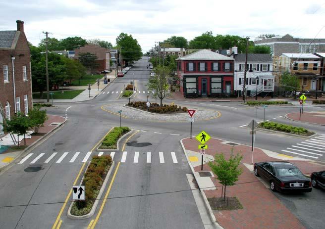
2 Presentation Outline Residential Traffic Circles - Used in low volume, typically residential areas - Installed or in development-34 Mini-Roundabouts - Used in higher volume, typically collector streets - One under construction Modern Roundabouts - Used at busier (often signalized) commercial/residential intersections - Installed or under development -9

3 Residential Traffic Circle Purpose: slow traffic in residential, low volume area Provide horizontal deflection 5 to 6 feet
 Allow left turns both around and in front of")
4 Richmond Model- City of Seattle, WA Sought FHWA guidance Over 1,000 installed Use Object Marker Obstruction Sign (OM1-3) Allow left turns both around and in front of circle
, one-way sign on larger circles, YIELD signs Neighborhood encouraged to maintain")
5 Design Criteria Must accommodate quint/emergency vehicle on left turn Accommodate thru tractor trailer movements (sometimes) Landscaping key: 1. tree s 2. shrub s 3. flowers Obstruction sign (left and right), one-way sign on larger circles, YIELD signs Neighborhood encouraged to maintain


6 Design Criteria Larger circles use one-way signs Intersection of Bruton, New Kent, and Riverside


7 Design Criteria Larger circles use oneway signs Intersection of McDonough and 32 nd

8 Performance 64% crash reduction (15 circles)
 Allows trucks to turn")

9 Mini- roundabout Smaller roundabout (up to 80 diameter) Allows trucks to turn left over circle Can fit within existing intersection boundaries, lowering costs

10 Richmond Example Bliley/Blakemore intersection Cost -approx. $50,000 -uses minimal -asphalt paver Construction - Fall, 2013


11 Current Richmond Roundabouts Lombardy and Admiral


12 Current Richmond Roundabouts Highland Park


13 Current Richmond Roundabouts Jefferson, 25 th and M


14 Current Richmond Roundabouts Monument and Allen


15 Current Richmond Roundabouts Duval and 8 th


16 Current Richmond Roundabouts Duval and 8th


17 Under Design Richmond Roundabouts Fairfield and 23 rd Award contract- Fall 2013 Before Pics


18 Under Design Richmond Roundabouts Nine Mile, Fairfield and M Award contract Fall 2013

19 Under Design Richmond Roundabouts Nine Mile, Fairfield and M

 Award contract December")
20 Under Design Richmond Roundabouts Six Points (Meadowbridge, Dill, 2 nd ) Award contract December 2013

21 Under Design Richmond Roundabouts Six Points (Meadowbridge, Dill, 2 nd )


22 Monument and Allen Upgrade Begin design - August 2013

23 Idlewood and Downtown Express Ramp

24 Idlewood and Downtown Express Ramp Begin Design - Fall 2013

25 Richmond Roundabouts Rejected A P. Hill Statue- Laburnum and Hermitage Roanoke and Forest Hill Hull and Belt Hull and 32 nd

26 Richmond Roundabouts Rejected Hull and Belt
27 Roundabout Crash Patterns Crashes Per Year Location Before After Comments Lombardy St & Admiral Rd All fender benders 1 st Ave., 3 rd Ave., Trigg St., Matthews St th, Jefferson & M Sts th & Duval St Monument Ave & Allen St Partial roundabout, 75% crashes wet conditions

28 Design Considerations- Signage MUTCD (2009) Section 2A.04, Excessive use of signs Regulatory and warning signs should be used conservatively because these signs, if used to excess tend to lose their effectiveness. Driver s attention should be focused on roundabout geometrics and other traffic

29 Design Considerations- Signage Highland Park

30 Design Considerations Speed Control Slow in-slow out

31 Design Considerations - Landscaping Robust Landscaping to Reinforce Geometrics Factors: 1. Trees and shrubs will enhance traffic control 2. Visually enhance crosswalks 3. Low maintenance


32 Design Considerations - Landscaping

33 Design Considerations - Lighting Use to enhance landscaping, emphasize pedestrian crossings and travel ways


34 Design Considerations - Lighting Use to enhance landscaping, emphasize pedestrian crossings Consider concentrating on pedestrian crossings Richmond roundabouts typically rely on traditional intersection cobra heads (would wash out lighting focused on pedestrian crossings)


35 Design Considerations - Lighting Consider solar road studs activated guiding lights system to guide driver Approaching car activates running lights as driver passes through roundabout, or simply have all lights on when dark.
36 Questions?
Rt 29 Solutions Hydraulic Planning Advisory Panel. September 28, 2017
 Hydraulic Planning Advisory Panel September 28, 2017 Agenda Item 1: Introductions Hydraulic Planning Advisory Panel members Technical Team members 2 Agenda item 2: Public Interaction and Feedback Live
LOCATION AND DESIGN DIVISION
 VIRGINIA DEPARTMENT OF TRANSPORTATION LOCATION AND DESIGN DIVISION INSTRUCTIONAL AND INFORMATIONAL MEMORANDUM GENERAL SUBJECT: Landscape Architecture Program NUMBER: SPECIFIC SUBJECT: Integration of Landscape
What s New in Roundabout Design?
 Roundabouts: An Informational Guide, 2 nd ed. What s New in Roundabout Design? National and State Perspective Brian Walsh, WSDOT Lee Rodegerdts, Kittelson & Associates, Inc. Overview & Philosophy Chapter-by-Chapter
Allen Street Civic District Redevelopment Area Plan Redevelopment Plan & Proposal State College Planning Commission State College Redevelopment
 Allen Street Civic District Redevelopment Area Plan Redevelopment Plan & Proposal State College Planning Commission State College Redevelopment Authority September 17, 2015 Discussion Points Overview of
Project Overview. Fairfax County Parkway Widening Fairfax County. Get Involved. Public Information Meeting. Contact Information
 Get Involved VDOT representatives will review and evaluate information received as a result of this meeting. Please fill out the comment sheet provided in this brochure if you have any comments or questions.
New Stanton Project Update July 3, 2012
 New Stanton Project Update July 3, 2012 The Needs BACKGROUND INFO I-70 Geometric Concerns Substandard Horizontal & Vertical Clearance at Center Ave. Bridge (The Center Avenue Bridge is Replaced in all
I.T.S. PLAN ALONG I-95 INSTALL FIBER OPTIC LINE PROJECT SHOWING Tuesday, June 18, 2013, 1:30pm Ashland Residency Conference Room
 I.T.S. PLAN ALONG I-95 INSTALL FIBER OPTIC LINE PROJECT SHOWING Tuesday, June 18, 2013, 1:30pm Ashland Residency Conference Room PROJECT SHOWING AGENDA I. Welcome A. Sign In Sheet; Non-Disclosure Agreement
The Village of Sugar Grove, in partnership with Kane County, the Illinois Department of Transportation, and the Illinois Tollway welcomes you to the
 The Village of Sugar Grove, in partnership with Kane County, the Illinois Department of Transportation, and the Illinois Tollway welcomes you to the first Public Meeting for the proposed interchange improvement
FHWA INVEST. And the Harbor Bridge Project
 FHWA INVEST And the Harbor Bridge Project FHWA s Sustainable Highways Initiative The Sustainable Highways Initiative supports programs and activities conducted across the Federal Highway Administration
2040 Long Range Transportation Plan
 2040 Long Range Transportation Plan Adopted: April 15, 2013 APPENDIX D HIGHWAY NEEDS PLAN PROJECTS FREDERICKSBURG Existing and Committed Projects Fall Hill Avenue/Mary Washington Blvd. (Fredericksburg)
Fifth and Detroit Street Design May 2017 Capital Improvements Committee. DOWNTOWN Street Design
 1 Fifth and Detroit Street Design May 2017 Capital Improvements Committee Agenda 2 Review Street Configuration Prior Meeting Review Outreach Synopsis Functional Street Design Refinements Curb Edge, Turning
GREENING THE BOULEVARD Master Plan Concepts for Venice Boulevard between Lincoln and Sawtelle
 GREENING THE BOULEVARD Katherine Spitz Associates Inc. 4212½ Glencoe Avenue Marina Del Rey, CA 90292 310 574 4460 Fax 574 4462 January 2008 Table of Contents Overview Proposed Design Improvements Illustration
Public input has been an important part of the plan development process.
 Lakewood s Comprehensive Plan recognizes that transportation helps shape the community, and that the way the community provides for the safe and efficient movement of people affects the character of the
Lehigh Acres Land Development Regulations Community Planning Project
 Lehigh Acres Land Development Regulations Planning Effort Summary In July, 2010 Commissioner Frank Mann invited the Lehigh Acres community to start discussing how to achieve their recently adopted community
Route 1 Corridor Study
 Route 1 Corridor Study Westbrook, Connecticut A Vision for the Connecticut Shoreline Public Informational Meeting July 28, 2015 Lower Connecticut River Valley Council of Governments Fitzgerald & Halliday,
Technical Bullet Series on Clay Brick Pavers
 2701 Shorefair Drive, Winston-Salem, NC 27105 pinehallbrick.com 1-800-334-8689 Technical Bullet Series on Clay Brick Pavers #4 Designing For Heavy Vehicular Traffic Abstract This Tech Bullet focuses on
Johnson Street Bridge Public Realm Update
 Johnson Street Bridge Public Realm Update August 20, 2015 Background Johnson Street Bridge Replacement Project impacts a diverse range of stakeholders In addition to a new bridge, the project also includes
Concluding Improvement Recommendations and Opinions of Probable Cost (calculated in may 2010 construction rates).
.") Pelican Bay Community Improvement Plan Traffic,JI Concluding Improvement Recommendations and Opinions of Probable Cost (calculated in may 2010 construction rates). D1 -A: Provide consistent signing, marking
Pelican Bay Community Improvement Plan Traffic,JI Concluding Improvement Recommendations and Opinions of Probable Cost (calculated in may 2010 construction rates). D1 -A: Provide consistent signing, marking
AGENDA ACTION ITEMS INFORMATION ITEMS
 NOACA Bicycle and Pedestrian Advisory Council Meeting Friday, March 21 st, 2014 10:30 a.m. NOACA Office 1299 Superior Avenue Cleveland, Ohio 44114 Phone: (216) 241-2414; website: www.noaca.org AGENDA ACTION
The Auburn Plan Designing the Future of Auburn February 28, 2005
 The Auburn Plan Designing the Future of Auburn February 28, 2005 Block-by-Block Bicycle Tour Aerial survey Focus Group Meetings September 7 and 8 Design Workshops October 11, 14, and 21 Revitalization
ARGENTA TRAIL (CSAH 28/63) REALIGNMENT SOUTH PROJECT (CP 63-25)
 REALIGNMENT SOUTH PROJECT (CP 63-25)") ARGENTA TRAIL (CSAH 28/63) REALIGNMENT SOUTH PROJECT (CP 63-25) Preliminary Design Report February 2015 Prepared For: City of Inver Grove Heights Dakota County Prepared By: Kimley-Horn and Associates,
ARGENTA TRAIL (CSAH 28/63) REALIGNMENT SOUTH PROJECT (CP 63-25) Preliminary Design Report February 2015 Prepared For: City of Inver Grove Heights Dakota County Prepared By: Kimley-Horn and Associates,
Const. ROADS - Description
 Road Projects make up the bulk of the capital expenditures for the township. For the term of this CIP, road projects total $9,843,000 or 72.0% of the total capital expenditures for all capital projects
Project Consulting Team:
 THE DOWNTOWN CHERRYVILLE LAND USE + STREETSCAPE MASTER PLAN WAS FUNDED THROUGH THE GENEROUS DONATIONS OF THE FOLLOWING: The Community Foundation of Gaston County ElectriCities of North Carolina The Cherryville
d Escoto, M. City of Chicago Streetscape and Urban Design Program, Chicago Department of Transportation. (2003). Streetscape Guidelines.
. Streetscape Guidelines.") WORKS CITED McCann, B., & Rynne, S. Planning Advisory Service, (n.d.). Complete streets: Best policies and implementation strategies (559). Retrieved from American Planning Association website: http://www.smartgrowthamerica.org/documents/cs/resources/cs-bestpractices-chapter5.pdf
WORKS CITED McCann, B., & Rynne, S. Planning Advisory Service, (n.d.). Complete streets: Best policies and implementation strategies (559). Retrieved from American Planning Association website: http://www.smartgrowthamerica.org/documents/cs/resources/cs-bestpractices-chapter5.pdf
Mississippi Drive Corridor Revitalization. A DestinationTransportation Project...
 Mississippi Drive Corridor Revitalization A DestinationTransportation Project... Mississippi Drive Corridor Revitalization Welcome! Tonight s Agenda: Further define the Scope of the Project Discuss the
CITY OF VACAVILLE PLANNING COMMISSION Agenda Item No. G.1 STAFF REPORT February 21, 2012 BRIGHTON LANDING SPECIFIC PLAN & DEVELOPMENT PROJECT
 CITY OF VACAVILLE PLANNING COMMISSION Agenda Item No. G.1 STAFF REPORT February 21, 2012 Staff Contact: Fred Buderi (707) 449-5307 TITLE: PURPOSE: BRIGHTON LANDING SPECIFIC PLAN & DEVELOPMENT PROJECT INFORMATIONAL
BUILDING SCALE AND SETBACKS 5 ELEMENTS:... 5 FAÇADES (COMMERCIAL/RESIDENTIAL) 5
 5") VISION STATEMENT 3 UTILIZATION OF THE GUIDELINES 3 IMPLEMENTATION 3 PROCEDURES FOR DESIGN REVIEW 3 LAND USE AND ZONING 4 LAND USE 4 ELEMENTS:... 4 ZONING 4 ELEMENTS:... 4 BUILDING SCALE AND SETBACKS 5
VISION STATEMENT 3 UTILIZATION OF THE GUIDELINES 3 IMPLEMENTATION 3 PROCEDURES FOR DESIGN REVIEW 3 LAND USE AND ZONING 4 LAND USE 4 ELEMENTS:... 4 ZONING 4 ELEMENTS:... 4 BUILDING SCALE AND SETBACKS 5
Ref: March 21, Ms. Jody Kablack Director of Planning and Community Development Town of Sudbury 278 Old Sudbury Road Sudbury, MA 01776
 35 New England Business Center Drive Suite 140 Andover, MA 01810-1066 Office: 978-474-8800 Fax: 978-688-6508 Web: www.rdva.com Ref: 7198 Director of Planning and Community Development Town of Sudbury 278
PROJECT SHOWING MINUTES
 PROJECT SHOWING MINUTES North Lynn Street Esplanade Improvements Project No. 0029-000-859, C501, B605 UPC No. 109813 November 1, 2017 10:00 a.m. 1911 North Ft. Myer Drive, LL-10, Arlington, VA Overview
Corridor Identity. Section 9. Introduction. Corridor Guiding Principles
 Corridor Identity An attractive and healthy community is a critical element of a quality place, and the design of quality places is a balance between environmental, economic, and social considerations.
New Braunfels Growth & Development. Garry Ford, Jr., P.E., PTOE City Engineer City of New Braunfels
 New Braunfels Growth & Development Garry Ford, Jr., P.E., PTOE City Engineer City of New Braunfels Overview Growth Development Transportation Water Challenges Addressing the Growth, Development and Challenges
Green Book 7 th Edition Summary of Changes. Jim Rosenow NCITE Geometric Design Committee August 30, 2018
 Green Book 7 th Edition Summary of Changes Jim Rosenow NCITE Geometric Design Committee August 30, 2018 Outline 1. The drama 2. Chapter 1 rewrite 3. The rest of the book 2 Outline 1. The drama 2. Chapter
Portage Parkway Environmental Assessment Public Information Centre No. 1
 City of Vaughan Portage Parkway Environmental Assessment Public Information Centre No. 1 November 25, 2015 Welcome to the Public Information Centre This first Public Information Centre (PIC) introduces
Call for Artists Gateway Island Ashland Oregon Requests for Qualifications (RFQ)
") Call for Artists Gateway Island Ashland Oregon Requests for Qualifications (RFQ) The Project The Ashland Public Art Commission (PAC) seeks an artist, or artist team, to develop a site specific, permanent,
Call for Artists Gateway Island Ashland Oregon Requests for Qualifications (RFQ) The Project The Ashland Public Art Commission (PAC) seeks an artist, or artist team, to develop a site specific, permanent,
North Hutchinson Island 7.55 Acres Vacant Land Approved for 30 Townhome Units
 OFFERING MEMORANDUM Contact: Yates & Company Realty, LLC 255 Alhambra Circle Suite 325, Coral Gables, FL 33134 Phone: 305-446-0406 Cell: 786-258-6500 Email: brendayates@bellsouth.net Website: www.yatesandcompany.net
Welcome & Introductions
 Creating a Pedestrian Friendly Street American Public Works Association: 2009 Congress Session 4791 September 16, 2009 Welcome & Introductions Doug Roberts, P.E. Transportation Design Section Manager City
The Arlington County Park and Recreation Commission and Department of Parks, Recreation and Cultural Resources. PEG APPLICATION FORM Fiscal Year 2012
 The Arlington County Park and Recreation Commission and Department of Parks, Recreation and Cultural Resources PEG APPLICATION FORM Fiscal Year 2012 I. Location of Proposed Project: Park Name (if applicable):
Meridian Hills Improvements
 Meridian Hills Improvements Public Information Meeting Background The Town Planning Committee - ad hoc committee established December 2005 Volunteer members Create a long-range plan of improvements that
Tonight s Agenda. Summary Presentation Open House. Group Discussion Next Steps: online community wide survey
 Community Open House February 22, 2018 Tonight s Agenda Summary Presentation Open House Station 1: Project Overview and Community Input Station 2: Draft Vision and Guiding Principles Station 3: Western,
117 E. Louisa St. #1 Seattle, WA January 29, 2016
 Alison Townsend, Strategic Advisor Seattle Department of Transportation P.O. Box 34996 Seattle, WA 98124-4996 Dear Ms. Townsend: 117 E. Louisa St. #1 Seattle, WA 98102-3278 January 29, 2016 The Eastlake
BRADENTON RIVERWALK EXPANSION MASTER PLAN
 BRADENTON RIVERWALK EXPANSION MASTER PLAN INTRODUCTION & AGENDA Process Update Community Engagement Summary Center for Active Design (CfAD) Recommendations Context and Existing Conditions Master Plan Alternatives
Chapter 1 - General Design Guidelines CHAPTER 1 GENERAL DESIGN GUIDELINES
 CHAPTER 1 GENERAL DESIGN GUIDELINES 1.0 INTRODUCTION This Publication has been developed to provide current, uniform procedures and guidelines for the application and design of safe, convenient, efficient
Cleveland Innerbelt Bridge / Central Viaduct Cleveland City Planning Commission October 2, 2009
 Cleveland Innerbelt Bridge / Central Viaduct Cleveland City Planning Commission October 2, 2009 New Westbound Bridge Schedule December 1, 2009 Contract Documents/Plan Package March 1, 2010 Request for
ROBINSON STREET WORKSHOP REPORT STREETSCAPE PRIORITIZATION
 PREPARED FOR Robinson Street Association 2nd Council District 5th Council District ROBINSON STREET WORKSHOP REPORT STREETSCAPE PRIORITIZATION DOWNTOWN 205 East Broad Street Richmond, VA 23219 CHURCH HILL
STANDARD SPECIFICATIONS Book 2 ENGINEERING DRAWINGS INCLUDES ADDENDUMS
 STANDARD SPECIFICATIONS Book 2 ENGINEERING DRAWINGS INCLUDES ADDENDUMS July 23, 2018 Page 1 of 7 STANDARD LEGEND SYMBOLS (September, 1973)... AS-101A STANDARD LEGEND SYMBOLS (September, 1973)... AS-101B
SCTPO Project Summary September 2014
 A1A MULTIMODAL CORRIDOR PLANNING AND ENGINEERING ANALYSIS Florida Department of Transportation SCTPO Project Summary September 2014 PRESENTATION FOOTER Meeting Agenda What We Plan To Do Project Background
VEHICULAR AND PEDESTRIAN CIRCULATION
 This perspective sketch communicates the intended character and quality of a proposed streetscape design. Locate benches near a major intersection where people tend to gather. Seating and lighting provide
Executive Summary. NY 7 / NY 2 Corridor
 Executive Summary NY 7 / NY 2 Corridor Transportation and Land Use Study December 2005 Prepared for: Town of Colonie Capital District Transportation Committee Prepared by: Introduction: Land use decisions
Future Proposed Development
 Future Proposed Development on and around Link light rail s Capitol Hill Station Meeting September 24, 2012 Tonight s Agenda 6:00 pm Open House 6:30 pm Introductions Richard Conlin, City of Seattle Councilmember/Sound
4/8/2015 Item #10D Page 1
 MEETING DATE: April 8, 2015 PREPARED BY: Christy Villa, Associate Civil Engineer DEPT. DIRECTOR: Glenn Pruim DEPARTMENT: Public Works CITY MANAGER: Larry Watt SUBJECT: NORTH COAST HIGHWAY 101 STREETSCAPE
RESOLUTION NO R
 e e RESOLUTION NO R04 0054 BE IT RESOLVED by the Mayor and City Council ofthe City ofpapillion that The Papillion Comprehensive Plan is hereby amended to incorporate the Option A Future Land Use Map Transportation
A/E REVIEW CHECKLIST SITE & LANDSCAPE
 A/E REVIEW CHECKLIST SITE & LANDSCAPE Reviewers should - Use Checklists when reviewing any type of VA construction project for the following disciplines: Architectural, Boiler Safety Devices Operation
Metro. Activity Center Design Guidelines. Recommendations For Developing Focused, Mixed-Use Commercial/Residential Centers
 Metro Activity Center Design Guidelines Recommendations For Developing Focused, Mixed-Use Commercial/Residential Centers Metro Activity Centers What is a MAC? Legacy, the adopted guide for the future growth
Fairfax County Parkway (Route 286) Widening Project
 Widening Project") Fairfax County Parkway (Route 286) Widening Project Route 29 (Lee Highway) to Route 123 (Ox Road) State Project No. 0286-029-259, P101; UPC 107937 Fairfax Station HOA Meeting January 30, 2018 7:00 to 9:00
Fairfax County Parkway (Route 286) Widening Project Route 29 (Lee Highway) to Route 123 (Ox Road) State Project No. 0286-029-259, P101; UPC 107937 Fairfax Station HOA Meeting January 30, 2018 7:00 to 9:00
The University District envisions, in its neighborhood
 Envisioning the University District Link Light Rail in Seattle s neighborhoods CIY OF SEALE CONCEP-LEVEL SAION AREA PLANNING RECOMMENDAION RESOLUION # 30165 EXHIBI L Vision 08.2000 he University District
Chapter 2, Section C: Urban Design and Visual Resources A. INTRODUCTION
 Chapter 2, Section C: Urban Design and Visual Resources A. INTRODUCTION This attachment considers the potential of the proposed East River Waterfront Access Project at Peck Slip to effect urban design
Sheridan Boulevard S TAT I O N A R E A P L A N S H E R I D A N B O U L E VA R D S TAT I O N A R E A P L A N
 Sheridan Boulevard S TAT I O N A R E A P L A N 1 City of Lakewood Adopted November, 2006 S H E R I D A N B O U L E VA R D S TAT I O N A R E A P L A N The Vision The City of Lakewood s overall vision is
Concept Evaluations 2 May 2009
 Concept Evaluations 2 May 2009 Evaluation Purpose The purpose of this evaluation is to gain feedback from the CRC and community on the ideas presented within the concepts and how the concepts relate to
December 1, 2014 (revised) Preliminary Report -- Thomas Jefferson Site Evaluation
 Preliminary Report -- Thomas Jefferson Site Evaluation") December 1, 2014 (revised) TO: FROM: RE Arlington County Board Thomas Jefferson Site Evaluation Working Group by Carrie Johnson, Chair Preliminary Report -- Thomas Jefferson Site Evaluation The Thomas
December 1, 2014 (revised) TO: FROM: RE Arlington County Board Thomas Jefferson Site Evaluation Working Group by Carrie Johnson, Chair Preliminary Report -- Thomas Jefferson Site Evaluation The Thomas
Atlanta BeltLine Subarea 3 Master Plan Update
 Atlanta BeltLine Subarea 3 Master Plan Update April 14, 2018 Workshop Meeting 1 22 miles, connecting 45 neighborhoods 22 MILES of transit 46 MILES of streetscapes and complete streets 33 MILES of urban
FDOT D4 Complete Streets
 FDOT D4 Complete Streets Context Sensitive Solutions Directs that complete street solutions will complement the context of the community. Collaborative approach to decision making, project development,
TO: Denver Planning Board FROM: Analiese Hock, Senior City Planner DATE: March 13, 2018 RE:
 Community Planning and Development Planning Services 201 W. Colfax Ave., Dept. 205 Denver, CO 80202 p: 720.865.2915 f: 720.865.3052 www.denvergov.org/cpd TO: Denver Planning Board FROM: Analiese Hock,
3 Focusing the Vision Following the second workshop, the Project
 3 Focusing the Vision Following the second workshop, the Project Team undertook the task of refining the Vision developed during the workshops. The final plan addresses participant desires while incorporating
Creating Complete Roadway Corridors:
 Creating Complete Roadway Corridors: The AASHTO Guide to Transportation Landscape Architecture and Environmental Design NCHRP Project 15-33 Status Report AASHTO Standing Committee on Design Technical Committee
SDOT DPD. SDOT Director s Rule DPD Director s Rule DCLU DR SED DR of 7 CITY OF SEATTLE
 SDOT SDOT Director s Rule 2-07 DPD Applicant: CITY OF SEATTLE Page 1 of 7 Supersedes: DCLU DR 11-93 SED DR 93-4 Seattle Department of Transportation (SDOT) Department of Planning and Development (DPD)
University of the District of Columbia Van Ness Campus Master Plan Community Open House 3. December 8, 2010
 University of the District of Columbia Van Ness Campus Master Plan Open House 3 December 8, 2010 Introductions Sequence of Work: Campus Master Plan BEGIN: INTRODUCE AND START WORK Project Initiation Team
Community Meeting November 18, 2015
 Top Concerns We ve Heard Use of Urban Road Code Total number of units and effect on schools and transportation Land swaps with Parks Department: how do these benefit the community? Zoning classifications:
I-25 / Rio Bravo Interchange. I-25 / Rio Bravo Interchange. Presenters 11/30/2016 THIRD PUBLIC MEETING DECEMBER 1, 2016 NMDOT CN A300280
 I-25 / Rio Bravo Interchange TONIGHT S MEETING SCHEDULE OPEN HOUSE 6:00 PM TO 6:30 PM PRESENTATION BEGINS AT 6:30 PM Q & A FOLLOWING PRESENTATION CN A300280 / PNA300280 I-25 / Rio Bravo Interchange THIRD
Roanoke Rapids Streetscape Master Plan. City Council Presentation
 SCHEDULE: Stakeholder Meeting/Kick off November,2016 Master Planning Phase (November March 2017) Public Meeting #1 December 13, 2016 Review Meeting with Key Stakeholders Refine Concepts Based on Input
PROJECTS UNDER CONSTRUCTION
 Project Name Project Status Project Funding Project Manager PJ 2144 Clayton Rd-Treat Blvd Intersection Improvements Widen the Clayton Road/Treat Blvd intersection and upgrade the traffic signal. Construction
4 January 11, 2012 Public Hearing APPLICANT:
 . 4 January 11, 2012 Public Hearing APPLICANT: MID-ATLANTIC AUTO PROPERTY OWNER: DZR, LLC STAFF PLANNER: Leslie Bonilla REQUEST: Conditional Use Permit (truck rental, automobile service, and automotive/bulk
New York Avenue Streetscape and Trail Project Public Meeting #1 Summary
 New York Avenue Streetscape and Trail Project Public Meeting #1 Summary I. King Jordan Student Academic Center (SAC) Gallaudet University, Washington, DC February 23, 2017 Table of Contents 1.0 Introduction...
FANSHAWE PARK ROAD/RICHMOND STREET INTERSECTION IMPROVEMENTS. PUBLIC INFORMATION CENTRE 2 June 16, 2016
 FANSHAWE PARK ROAD/RICHMOND STREET INTERSECTION IMPROVEMENTS Municipal Class Environmental Assessment PUBLIC INFORMATION CENTRE 2 June 16, 2016 ACCESSIBILITY Under the Accessibility Standards 2015 for
California Environmental Quality Act (CEQA) Environmental Review Process
 Environmental Review Process") California Environmental Quality Act (CEQA) Environmental Review Process Los Angeles Union Station Forecourt and Esplanade Improvements constitute a Project Los Angeles County Metropolitan Transportation
California Environmental Quality Act (CEQA) Environmental Review Process Los Angeles Union Station Forecourt and Esplanade Improvements constitute a Project Los Angeles County Metropolitan Transportation
Response: The public school use, including the SWM facility, is within the R-1 District.
 Loudoun County School Board Dulles North Elementary School (ES-31) CMPT 2017-0006 and SPMI 2017-0015 First Response to Referral Comments Zoning Administration Comments dated October 2, 2017 Comment 1:
BENJAMIN BANNEKER PARK FRAMEWORK PLAN (PLAN ADOPTION)
") BENJAMIN BANNEKER PARK FRAMEWORK PLAN (PLAN ADOPTION) COUNTY BOARD MEETING DECEMBER 16, 2017 County Board Consideration: Adopt the Benjamin Banneker Park Framework Plan and Design Guidelines Framework
BENJAMIN BANNEKER PARK FRAMEWORK PLAN (PLAN ADOPTION) COUNTY BOARD MEETING DECEMBER 16, 2017 County Board Consideration: Adopt the Benjamin Banneker Park Framework Plan and Design Guidelines Framework
Seattle Transit Master Plan
 Seattle Transit Master Plan Seattle City Council Transportation Committee Briefing May 10, 2011 Seattle Department of Transportation Presentation Outline Review of project schedule and goals Review of
Old Town Neighborhoods Plan. Choices Event Wednesday, December 9, 2015
 Old Town Neighborhoods Plan Choices Event Wednesday, December 9, 2015 Agenda 6:00 6:10 p.m. Welcome + Sign In 6:10 6:30 p.m. Presentation 6:30 8:00 p.m. Workshop + Open House Seeking your input on: Neighborhood
Union Station Master Plan Task 2 Briefing
 Union Station Master Plan Task 2 Briefing Goals and Organization for Tonight s Meeting Presentation Master Plan Schedule and Scope Key Findings Guiding Principles Alternatives Process Draft Alternatives
CITY OF WESTERVILLE, PLANNING AND DEVELOPMENT. BASSEM BITAR / (614) /
 /") Staff Report Meeting Date: September 21, 2016 Case #: PC 2016-17 WESTERVILLE PLANNING COMMISSION Request: Applicant: Staff Liaison: RECOMMEND TO CITY COUNCIL FOR ITS FURTHER ACTION THE IMAGINE WESTERVILLE
Staff Report Meeting Date: September 21, 2016 Case #: PC 2016-17 WESTERVILLE PLANNING COMMISSION Request: Applicant: Staff Liaison: RECOMMEND TO CITY COUNCIL FOR ITS FURTHER ACTION THE IMAGINE WESTERVILLE
West Kendall Corridor June 11, 2014
 June 11, 2014 Miami-Dade County Department of Regulatory and Economic Resources Development Services Division ā 1 Presentation Outline Review Study Area Review of Citizens Plans and Presentations Planning
3. Additional driveways may be permitted where determined by the Planning Commission to adequately accommodate traffic or ensure public safety.
 ARTICLE 10 ACCESS MANAGEMENT Section 10.01 Purpose. The purpose of this Article is to protect the substantial public investment in the City s street system by preserving the traffic capacity of existing
Proposed Kenmount Hill CDS Amendment. Public Hearing October 25 th, 2018
 Proposed Kenmount Hill CDS Amendment Public Hearing October 25 th, 2018 History of Kenmount Hill Why Kenmount Hill? Why Now? We are a city with a vision for growth and the development of Kenmount Hill
TRAFFIC ENGINEERING DIVISION INSTRUCTIONAL & INFORMATIONAL MEMORANDUM
 VIRGINIA DEPARTMENT OF TRANSPORTATION TRAFFIC ENGINEERING DIVISION INSTRUCTIONAL & INFORMATIONAL MEMORANDUM GENERAL SUBJECT: Barrier Systems SPECIFIC SUBJECT: Guardrail System Spot Repair Condition Ratings
Welcome to the. Open House
 Welcome to the 5th Street to Kinsman Road Open House November 14 5:30 7:00 p.m. Please sign in Project Overview In December 2016, City Council adopted SW 5th Street as the preferred alignment to connect
Workshop 3. City of Burlington Waterfront Hotel Planning Study. September 14, The Planning Partnership
 Workshop 3 City of Burlington Waterfront Hotel Planning Study September 14, 2017 The Planning Partnership The Waterfront Hotel Planning Study 01 The Brant & Lakeshore Planning Study will establish a Strategic
Innovative Transportation Planning, Design & Technology in Fairfax County, VA
 Innovative Transportation Planning, Design & Technology in Fairfax County, VA American Society of Highway Engineers (ASHE) November 16, 2016 Presented By W. Todd Minnix, PE Chief, Transportation Design
Creative Engineering Group Inc, (Creative) Construction Engineering and Inspection (CEI) Professionals
 Construction Engineering and Inspection (CEI) Professionals") ABOUT US Creative Engineering Group Inc, (Creative) is a Construction Engineering and Inspection (CEI) firm established in 2006 by two Principals Rick Estripeaut & Sri Mavanur. In the last decade Creative
ABOUT US Creative Engineering Group Inc, (Creative) is a Construction Engineering and Inspection (CEI) firm established in 2006 by two Principals Rick Estripeaut & Sri Mavanur. In the last decade Creative
HARBOR BRIDGE. Randall C. Grones, PE - SPD. US 181 Harbor Bridge October
 HARBOR BRIDGE Randall C. Grones, PE - SPD US 181 Harbor Bridge October October 13, 13, 2015 2015 Project Scope Develop, design, construct and maintain a total project length of 6.44 miles. Base scope New
City of Burlington Downtown Street Design & Construction Standards
 City of Burlington Downtown Street Design & Construction Standards Adopted April 16, 2018 b City of Burlington Downtown Street Design Standards CITY OF BURLINGTON, VT The Great Streets Initiative is a
Dogpatch/22nd Street Greening
 TEAM MEMBERS Prepared for: GreenTrustSF Central Waterfront www.gtsfcw.org Prepared by: Fletcher Studio San Francisco, CA www.fletcherstudio.com Landscape Architecture Urban Design Environmental Planning
The following concept plans and illustrations are the result of this 10 month study of the alley connections from CSU to the River District.
 W E L C O M E T O T H E F O R T C O L L I N S D O W N T O W N A L L E Y S A N D I N T E G R AT E D W A L K W AY S M A S T E R P L A N O P E N H O U S E The following concept plans and illustrations are
Rt 29 Solutions Hydraulic Planning Advisory Panel. September 14, 2017
 Hydraulic Planning Advisory Panel September 14, 2017 Agenda Item 1: Introductions Hydraulic Planning Advisory Panel members Technical Team members 2 Agenda item 2: Public Interaction and Feedback Live
Appendix L 2006 LADOT Pedestrian and Traffic Counts
 Appendix L 2006 LADOT Pedestrian and Traffic Counts This page has been intentionally left blank. MTA BOARD MEETING DECEMBER 4, 2003 M etropoli tan Transportation Authority One Gateway Plata Los Angeles,
Achieving a Vision. Master Plan 2009 Belknap Campus August 10 11, UofL Belknap Campus Master Plan Update
 Achieving a Vision Master Plan 2009 Belknap Campus August 10 11, 2009 Consultant Team The Campus Studio Ann Arbor Michigan Team Leader Campus Planning Site Design JRA Architects Louisville Kentucky Assistant
Status Update (2006 vs. Now) Citizen s Advisory Committee February Plan for Prosperity
 Citizen s Advisory Committee February Plan for Prosperity") Status Update (2006 vs. Now) Citizen s Advisory Committee February 2018 Plan for Prosperity 2000 2017 2000 2017 Gardnerville Population 6,000 5,760 5746 5,500 5,000 5,067 5,550 5,165 5,394 5,412 5,250
Status Update (2006 vs. Now) Citizen s Advisory Committee February 2018 Plan for Prosperity 2000 2017 2000 2017 Gardnerville Population 6,000 5,760 5746 5,500 5,000 5,067 5,550 5,165 5,394 5,412 5,250
POCKET COMMUNITY PLAN
 POCKET COMMUNITY PLAN Part Three : COMMUNITY PLAN AREAS AND SPECIAL STUDY AREAS CONTENTS Community Location... 3-P-3 Community Vision... 3-P-4 Community Profile... 3-P-4 Community Issues... 3-P-6 Land
Portland was a beautiful city, but in the 1960s and 1970s, its population grew very fast.
 4 Portland, Oregon, 1973 After reading Section 4, identify three challenges facing Portland in 1973. Record them in the boxes below. Draw a line from each box to the part of the city most affected by that
Request for Proposals: Architectural/Design Guidelines
 Request for Proposals: Architectural/Design Guidelines January 11, 2017 1.0 INTRODUCTION The City of Issaquah, Washington is soliciting proposals from qualified consulting firms to lead a community conversation
WELCOME WHY A TEMPORARY PATHWAY? WE WANT TO HEAR FROM YOU
 WELCOME In March, the City of Vancouver purchased the lands known as the Arbutus Corridor from Canadian Pacific Railway for the purpose of creating a transportation corridor from False Creek to the Fraser