Fort McPherson Master Plan
|
|
|
- Francine Manning
- 5 years ago
- Views:
Transcription

1 Fort McPherson Master Plan


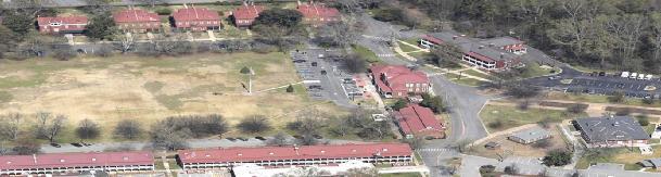
2 Fort McPherson In 1885, Fort McPherson became the first permanent Army installation in the Southeast. Located on 488 acres in the City of Atlanta halfway between the airport and downtown. Home of: US Army Forces Command US Army Reserve Command US Army Central Command McPherson is being closed under the Base Realignment and Closure Act (BRAC) on September 15, 2011.
3 McPherson Implementing Local Redevelopment Authority Jack Sprott is the Executive Director of MILRA Following the announcement of BRAC the affected jurisdiction creates a Local Redevelopment Authority. The purpose is to develop a plan for the property that will foster long-term economic recovery for the community after closure. The LRA is the primary link between the Department of Defense, the installation, the community and Federal and State agencies for all base closure matters.
4 McPherson Implementing LRA Redevelopment Guidelines Guided by market realities and adaptable to changing conditions. Target knowledge-based industries Generate jobs and mixed-income neighborhoods Economically uplift surrounding communities-benefitting residents Enhance community services and promote life-long learning Develop through collaborative processes Honor the history of the site Promote sound environmental and energy efficient concepts Promote green space Coordinate with other regional developments
5 Sustainable Urbanism Evaluates development from environmental, economic and social perspectives. Achieve a unique sense of community and space. Expand the range of transportation, employment and housing options. Equitably distribute the costs and benefits of development. Preserve and enhance natural and cultural resources. Promote public health.
6 Keys to Achieving Sustainable Urbanism Community and stakeholder collaboration in development. Make development decisions predictable, fair, and cost effective. Mix land uses. Use compact building design. Create a range of housing opportunities. Create walkable communities. Preserve open space and natural beauty. Direct development towards existing communities. Provide a variety of transportation choices.

7 Transportation Choices The MARTA stations located at the northeast and southeast corners of the base link the community to Atlanta and the airport.

8 Walkable Community Creating a block structure that lends itself to being more walkable helps connect the community within and to surrounding neighborhoods.

9 Preserve + Restore Open Space Preservation of open space is an amenity for residents, and part of the stormwater strategy for the redevelopment.

10 Mix Land Uses The blend of office residential, research, open space and retail uses give people the option to truly work, live, learn and play in one place.


11 5 miles Downtown Atlanta Georgia Tech Atlanta University Center Georgia State University Oakland City Lakewood / Ft. McPherson Hartsfield / Jackson Atlanta Airport Source: Sasaki, 2008

12


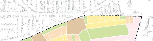
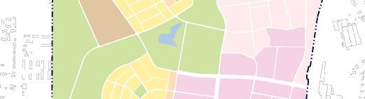
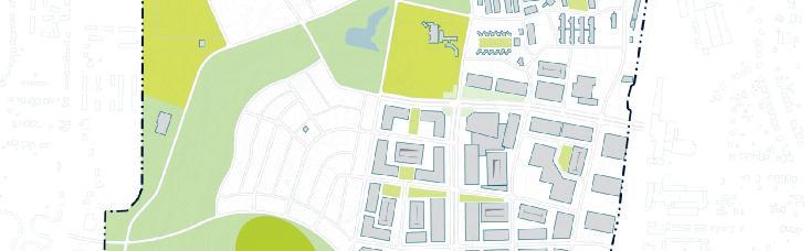
13 Development Districts Campbellton Neighborhood Historic District VA Parkway Neighborhood Science & Technology Open Space

14 Science and Technology Center District


15 District Elements Medical Use Collaborative space enables future Primary & Research Towers. Main Street Retail & Research/Office in a walkable environment. Research & Development Flex Facilities Inexpensive space for emerging companies. Build to Suit Office Space for established companies needing easy Airport access.

16 Historic Village District


17 Village Elements Parade Ground Active and passive recreation picnics to polo. Artist Bungalows Café s, B&B, galleries, studios, live/create space. Open Air Market Near MARTA to activate NE corner of space. New Residential Housing Transition Staff Row to existing residential.

18 Veteran s Affairs District


19 Parkway Neighborhood Frontage along 130-acre park and greenspace. Access to trail system and Science Park. Community Center and Pocket Park. Density transitions from active to passive uses.


20 Campbellton Neighborhood Neighborhood School early childhood through 8 th grade. Community Center and Pocket Park with community garden. Grocery Store provides for an underserved area. Neighborhood Commercial quality retail for the neighborhood.


21 Open Space Parade Ground Recreation Center Passive Space Event Space Community Gardens
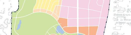

22 Land Use

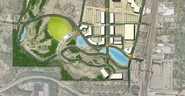
23 Master Plan Phase 1
24 Phasing: Demolition

25 Phasing: New Construction (Phase 1)

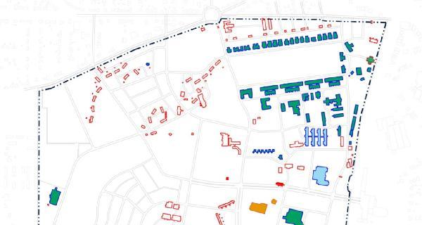
26 Existing & New Buildings


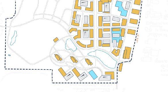
27 Land Use: Open Space


28 Transportation
29 SUMMARY - COMMERCIAL Office Research Medical VA Amenities Hotel Total Commercial 1,072,000 SF 1,508,379 SF 560,000 SF 75,000 SF 164,000 SF 180,000 SF 3,557,379 SF


30 HOK Proposed Master Plan DISTRICTS A Historic District Preserves and protects historic buildings and structures and allows for compatible reuse/infill B VA District C Employment Center District Provides for a mix of research & development, integrated Main Street retail and office D Residential District Provides for a variety of housing types E Green Space District Provides for a variety of active and passive recreation uses F Mixed Use District Provides for high density residential

31 HOK Proposed Zoning Districts 3 1 Historic Preservation Main Street 3 Neighborhood Commercial 4 Integrated Bio-Medical Research Center 5 Low Density Residential 6 Medium Density Residential High Density Residential 8 Active Recreation Green Space 9 Natural Green Space 6 10 Parade Ground, Special Events Space
32 SUMMARY - RESIDENTIAL Single Family Townhouses Historic Multi-Family Apartments Residential HUD Total Residential 201 Units 229 Units 31 Units 1,040 Units 286 Units 1,787 Units
33 Summary by District Campbellton Neighborhood Acres Science and Technology Acres Open Space Acres Historic Village Acres VA Acres Parkway Neighborhood Acres


34 SF Residential Townhouses Mixed Use Res. Existing Buildings Medical Use Science Park Event Space New School New Grocery Neighborhood Commercial Hotel Conference Parade Ground Open Air Market VA Clinic Streetcar Station Historic Bungalow Housing


35
36 For Additional Information Darlene Hawksley Director of Real Estate and Business Engagement
PLAN ELEMENTS WORKSHOP. April 5, 2016
 PLAN ELEMENTS WORKSHOP April 5, 2016 needs more housing. But there is no one-size fits-all solution. Every neighborhood has its own character. In some places, density is not only appropriate it is badly
Murphy Crossing Site Redevelopment Community Engagement Meeting September 19, 2016
 Murphy Crossing Site Redevelopment Community Engagement Meeting September 19, 2016 SUMMARY 1 EXECUTIVE SUMMARY STATEMENT OF PURPOSE ABI has conducted a detailed study of 1. Market potential 2. Building
Atlanta BeltLine Corridor Environmental Study. Scoping Meeting August 2008
 Atlanta BeltLine Corridor Environmental Study Scoping Meeting August 2008 What Will We Be Discussing Today? Study Overview - How Did We Get Here? - What Is the Study About? - Who Is Involved? - Where Is
Municipal Plan*Assessment
 Municipal Plan*Assessment This tool was developed to assist in reviewing municipal master plans and in determining if these plans are consistent with smart growth principles, neighboring municipal plans,
Mountain View & Old Dixie Node Master Plans CLAYTON COUNTY BOARD OF COMMISSIONERS. October 16, 2018
 Mountain View & Old Dixie Node Master lans CLAYTON COUNTY BOARD OF COMMISSIONERS October 16, 2018 Downtown Hapeville MOUNTAIN VIEW Hartsfield-Jackson Atlanta International Airport Mountain View: 750 Acres
THE NEIGHBORHOOD TODAY
 THE NEIGHBORHOOD TODAY CORE AREA VISION How are we Good Urbanism A Site s DNA thinking about Elements of great Unique elements urban communities embedded in a place the site and design? ELEMENTS LIKE:
GPA FALL 2017 CONFERENCE
 Change in Doraville Doraville at the beginning of a new era Design Doraville (Comp. Plan) adopted in 2016 Doraville Town Center Masterplan LCI (2005) Downtown Doraville Masterplan LCI (2010) 2014 Adoption
Former Rockcliffe Airbase Community Design Plan Guiding Design Vision and Principles December 4, 2013
 APPENDIX 5 - Guiding Design Vision and Principles Former Rockcliffe Airbase Community Design Plan Guiding Design Vision and Principles December 4, 2013 Vision Statement The redevelopment of the former
Atlanta BeltLine, Inc. Pathways to Urban Sustainability
 Atlanta BeltLine, Inc. Pathways to Urban Sustainability September 30, 2010 WHAT IS THE ATLANTA BELTLINE? Transit 22-mile loop Parks 1300 + new acres Trails 33 miles Jobs & Economic Development 20 areas,
Cultivate Hopkins: Built Environment. Comprehensive Plan Advisory Committee September 13, 2017
 Cultivate Hopkins: Built Environment Comprehensive Plan Advisory Committee September 13, 2017 Four Dimensions of a Sustainable Plan Land Use Urban Design Housing Transportation Resilience Water Resources
RESEDA - WEST VAN NUYS COMMUNITY PLAN
 RESEDA - WEST VAN NUYS COMMUNITY PLAN Executive Summary As part of the initial outreach effort, the Department of City Planning hosted two workshops for the Reseda-West Van Nuys Community Plan Area during
BeltLine Corridor Environmental Study
 BeltLine Corridor Environmental Study Joint TAC and SAC Meeting December 8, 2008 What We Will Discuss Today Outreach and Agency Coordination Scoping Results Existing Conditions Historical and Archeological
Coastal Smart Growth Approaches for Working Waterfront Preservation, Implementing Locally-Based Strategies and Solutions
 Coastal Smart Growth Approaches for Working Waterfront Preservation, Implementing Locally-Based Strategies and Solutions National Working Waterfronts Symposium March 26, 2013 Presented by: Lydia Bennett
Urban Form Case Studies
 Urban Form Case Studies Elana Horowitz Ontario Growth Secretariat Ministry of Energy and Infrastructure MINISTRY OF ENERGY AND INFRASTRUCTURE 1 Presentation Structure Role of the Ontario Growth Secretariat
Atlanta BeltLine. Subareas 9 & 10. Master Plan Updates. March 26, Washington Park Jamboree 1
 Atlanta BeltLine Subareas 9 & 10 Master Plan Updates March 26, 2018 Washington Park Jamboree 1 22 miles, connecting 45 neighborhoods 22 MILES of transit 46 MILES of streetscapes and complete streets 33
Status Report: MD 355 Project
 Status Report: MD 355 Project OCTOBER 2006 M-NCPPC MONTGOMERY COUNTY PLANNING DEPARTMENT Summary of Community Comments, and break to the Results of the MD 355 Participation Session Brookside Gardens -
ASPEN HILL Minor Master Plan Amendment
 ASPEN HILL Minor Master Plan Amendment Project Briefing Planning Board Agenda Item #7 Andrea Gilles, Area 2 June 5, 2014 Briefing Purpose 1. Follow-up evaluation on Mixed-Use land use in the Minor Amendment
LEED-ND 101: Practical Strategies for Achieving Sustainability Goals. Travis Parker Lakewood Planning Director
 LEED-ND 101: Practical Strategies for Achieving Sustainability Goals Travis Parker Lakewood Planning Director Metro Vision Idea Exchange Oct 11, 2012 West Corridor Stations West Corridor Overview West
FOR IMMEDIATE RELEASE Contact: Dyana Koelsch
 FOR IMMEDIATE RELEASE Contact: Dyana Koelsch 401.831.1200 dkoelsch@nharbor.com Revised Gateway Plan Decreases Retail, Adds 70% More Office Space and Improves Entrance to Quonset Business Park Incorporating
Shima Hamidi, PhD Director
 1OUR HISTORY 1OUR HISTORY 2OUR 1OUR HISTORY 2OUR 1OUR HISTORY Shima Hamidi, PhD Director OUR 3REPUTATION 1967 In 1967, the Texas Legislature created the at the University of Texas at Arlington. Based in
Official Plan Review
 Official Plan Review Summary Report - The Built Environment August 2014 Part 1: Introduction Planning for a healthy, prosperous and sustainable community is an important goal for our municipality. From
LAND USE OVERVIEW WHAT YOU WILL FIND IN THIS CHAPTER
 LAND USE WHAT YOU WILL FIND IN THIS CHAPTER Information about the City s expected population and employment growth. Description and capacity of existing and future land use designations. Policies that
Behnke Ranch Property, Pasco County: Master Plan Development Approach
 February 24, 2014 , Pasco County: Master Plan Development Approach Location & Program The (Legacy PUD) is located in southwest Pasco County along State Road 54 approximately 1.5 miles west of the Suncoast
Visioning Statement and Guiding Principles
 Visioning Statement and Guiding Principles Planning for the Future The General Plan The General Plan represents Woodland's shared vision of the future and defines a path to lead the community toward its
Environmental Assessment. Appendix E Visual And Aesthetic Conditions Technical Report
 Environmental Assessment Appendix E Visual And Aesthetic Conditions Technical Report Visual & Aesthetic Conditions Kansas City Streetcar Main Street Extension December 20, 2018 02 Contents 1. Introduction...
4 C OMMUNITY D ISTRICTS
 4 C OMMUNITY D ISTRICTS N ew development in the Area will include many different types of land uses, including a destination retail area that attracts people from all over the region; recreation opportunities
Prince George s County Economic Development Corporation David Iannucci President & CEO
 Prince George s County Economic Development Corporation David Iannucci President & CEO WBC REGIONAL ECONOMIC DEVELOPMENT FORUM THE FUTURE OF PRINCE GEORGE S COUNTY Wednesday, March 6, 2019 Why Prince George
REGIONAL ACTIVITY CENTER
 DRAFT REGIONAL ACTIVITY CENTER 70 EAST BENCH MASTER PLAN DRAFT 06 Introduction The East Bench Regional Activity center is comprised of large educational, research, medical, and employment centers. These
LEED FOR PLANNERS OCT 2009
 OCT 2009 What is LEED ND Overview History LEED ND Rating System Smart location and linkage Neighborhood Pattern and Design Green Infrastructure and Buildings Innovation and Design Process Project Example
4 LAND USE DESIGNATIONS
 4 LAND USE DESIGNATIONS Chapter 4 describes the land use designations and densities that will implement the development vision for North Burlingame outlined in Chapter 3. Land use densities are described
2036 Comprehensive Plan Community Agenda Volume 1 of 3 Community Assessment Volume 2 Technical Appendix Volume 3
 SMALL-TOW N ATMOSPHERE PARKS & TRAILS TOURISM CENTER 2036 Comprehensive Plan Community Agenda Volume 1 of 3 Community Assessment Volume 2 Technical Appendix Volume 3 TRADITIONAL NEIGHBORHOODS REGIONAL
BeltLine Corridor Environmental Study
 BeltLine Corridor Environmental Study Citywide Conversation on Transit and Trails April 2, 2009 Agenda & Introductions Introductions Environmental Study Process Overview of the BeltLine Project BeltLine
DOMINION BOULEVARD CORRIDOR STUDY AND ECONOMIC DEVELOPMENT STRATEGIC PLAN A MODEL FOR CHESAPEAKE S FUTURE
 DOMINION BOULEVARD CORRIDOR STUDY AND ECONOMIC DEVELOPMENT STRATEGIC PLAN A MODEL FOR CHESAPEAKE S FUTURE Overview I. Draft Plan Process II. Draft Plan Overview a. Market Analysis b. Master Land Use Plan
FUNDING CORRIDOR REVITALIZATION
 FUNDING CORRIDOR REVITALIZATION Integrated corridor planning for the 21 st Century America Planning Association Annual Conference Atlanta, GA April 27, 2014 Mariia Zimmerman, MZ Strategies, LLC mariia@mzstrategies.com
ITA and Vicinity Master Plan Update
 1 ITA and Vicinity Master Plan Update PHASE 3 SEPTEMBER 27, 2017 Three Phase Process 2 Phase 1 - Understanding October 13th Public Meeting Phase 2A - Exploring Ideas November 17th Public Meeting Phase
Mariposa Lakes. Planned Community. Project Overview. Stockton, CA
 Planned Community Stockton, CA Project Overview March 2007 Summary of Proposed Community is a master-planned community proposed for development on approximately 3,810 acres in southeast Stockton. In 2004,
Promoting Economic Development Through Upfront SEPA Review: Lessons from South Downtown Tacoma
 Promoting Economic Development Through Upfront SEPA Review: Lessons from South Downtown Tacoma 1 This session will focus on the City of Tacoma s South Downtown Subarea Plan and associated Non-Project SEPA
Affordability & Equity
 Affordability & Equity 1. Impact Fees 2. Displacement Prevention- build more housing to meet growth demands 3. Density Bonuses 4. Regional Housing Bond 5. Stricter Condominium Conversion Laws 6. Vacant
Plano Tomorrow Vision and Policies
 Plano Tomorrow Vision and Policies PLANO TOMORROW PILLARS The Built Environment The Social Environment The Natural Environment The Economic Environment Land Use and Urban Design Transportation Housing
Corridor Vision. 1Pursue Minnehaha-Hiawatha Community Works Project. Mission of Hennepin County Community Works Program
 1Pursue Minnehaha-Hiawatha Community Works Project Minnehaha-Hiawatha Community Works is a project within the Hennepin Community Works (HCW) program. The mission of the HCW program is to enhance how the
Spatial Areas of Practice AICP EXAM REVIEW. February 20, 2009 Georgia Tech Student Center Gary A. Cornell, FAICP
 Spatial Areas of Practice AICP EXAM REVIEW February 20, 2009 Georgia Tech Student Center Gary A. Cornell, FAICP Acknowledgement Thanks to Mary M. Shaw, AICP Planning at the National Level Federalism in
TOD 203 CORRIDOR PLANNING and TOD
 2 CORRIDOR PLANNING and Scales of What You Will Learn The Transit Corridor Types of Corridors Objectives and Strategies for Transit and at the Corridor Level Main Street Corridor Planning and Your Trainers
BROOKHILL NEIGHBORHOOD MODEL ZONING MAP AMENDMENT PREFACE TO APPLICATION
 BROOKHILL NEIGHBORHOOD MODEL ZONING MAP AMENDMENT PREFACE TO APPLICATION June 15, 2015 Revised: August 1, 2016 I. VISION Brookhill is a proposed community based upon the principles of Albemarle County
Midtown Greenway Land Use and Development Plan Executive Summary
 Midtown Greenway Land Use and Development Plan Executive Summary Introduction The Midtown Greenway Land Use and Development Plan sets policy direction for land use and development in the Midtown Greenway
RESILIENT COMMUNITIES PROJECT CITY OF MINNETONKA
 RESILIENT COMMUNITIES PROJECT CITY OF MINNETONKA BUILDING COMMUNITY-UNIVERSITY PARTNERSHIPS FOR SUSTAINABILITY Presentation to The League of Women Voters March 16, 2013 Julie Wischnack, Community Development
Robbinsdale LRT Station. CDI Development Guidelines. August Overview
 Robbinsdale LRT Station August 2018 Overview The City of Robbinsdale may have the coolest opportunity site along the 13 mile stretch of the Bottineau LRT corridor / Blue Line extension. Located a block
April 21, 2007 CCRP Workshop Summary
 April 21, 2007 CCRP Workshop Summary Group 1 1. Reuse around BART with a lot of housing and jobs 2. Greenway around creek 3. Transit and auto connection all through the site from Kirker Pass to Port Chicago
U T D N o r t h C a m p u s T O D and D o w n t o w n D e n t o n T O D
 U n i v e r s i t y o f T e x a s a t D a l l a s C i t y o f R i c h a r d s o n U T D N o r t h C a m p u s T O D and D o w n t o w n D e n t o n T O D Rick Leisner, AICP Assistant Director of Development
greenprint midtown SUSTAINABILITY ACTION PLAN 2012
 greenprint midtown SUSTAINABILITY ACTION PLAN 2012 MIDTOWN ALLIANCE SOUTHFACE ENERGY INSTITUTE RENAISSANCE PLANNING GROUP SUSTAINABLE ATLANTA PERKINS+WILL 2 GREENPRINT MIDTOWN 1. Introduction Sustainability
City of Tacoma Planning and Development Services
 Agenda Item E-1 City of Tacoma Planning and Development Services To: Planning Commission From: Elliott Barnett, Planning Services Division Subject: Tacoma Mall Regional Center Subarea Plan and EIS Meeting
M E M O R A N D U M January 6, 2017
 Item #4 M E M O R A N D U M January 6, 2017 To: 2035 Corridor Planning Committee From: Kenneth Baker, Sr. Director of Planning and Development Services Subject: Item #4 Overview Fidelis Purpose: Review
Oakland City Fort Mac LCI Plan
 Oakland City Fort Mac LCI Plan in association with City of Atlanta, Atlanta Regional Commission, Invest Atlanta, and Fort Mac LRA EXECUTIVE SUMMARY March 2016 SIZEMORE GROUP in association with THE COLLABORATIVE
New Partners for Smart Growth Conference February 5, 2010
 Dan Stroh, Planning Director City of Bellevue Planning and Community Development Bellevue, WA New Partners for Smart Growth Conference February 5, 2010 Summary of Project Long-range plan update for Bel-Red
General Plan Infill Policies (workshops and hearings)
") COMMUNITY PROCESS General Plan Infill Policies (workshops and hearings) Stockton Greater Downtown Housing Strategy (2007-2008) Housing Action Team Property owner meetings Community workshop Planning Commission
COMMUNITY PROCESS General Plan Infill Policies (workshops and hearings) Stockton Greater Downtown Housing Strategy (2007-2008) Housing Action Team Property owner meetings Community workshop Planning Commission
But What About the People? The Role of Urban Planning and Green Infrastructure
 But What About the People? The Role of Urban Planning and Green Infrastructure The Southeast Conservation Adaptation Strategy: A Model for Collaborative Conservation David Rouse, FAICP, ASLA Managing Director,
S A C R A M E N T O C O U N T Y JACKSON HIGHWAY & GRANT LINE EAST VISIONING STUDY
 JACKSON HIGHWAY & GRANT LINE EAST S A C R A M E N T O C O U N T Y P L A N N I N G D E P A R T M E N T SUMMARY AND WORKBOOK November 19, 2008 History of the Visioning Study Sacramento County has two growth
Heart of the Triad A Dynamic Plan for the Future. Steering and Technical Meeting April 27, 2006
 Heart of the Triad A Dynamic Plan for the Future Steering and Technical Meeting April 27, 2006 The Week in Review Specific Group Findings There Was Uniform Agreement the Time Was Right Growth is Imminent
EXECUTIVE SUMMARY DRAFT CHAPTER 1 INTRODUCTION EXECUTIVE SUMMARY
 CHAPTER 1 EXECUTIVE SUMMARY INTRODUCTION Through the joint efforts of the City of Tulsa planning staff and the Land Services division of Indian Nations Council of Governments (INCOG), the Berryhill Land
Sewanee Village + Request for Builder/Developer Proposals
 Sewanee Village + Request for Builder/Developer Proposals Contact: Frank X. Gladu Special Assistant to the Vice Chancellor University of the South 735 University Ave Version 3 Sewanee TN 37383 Released:
Comprehensive Plan Advisory Panel Meeting #3
 Comprehensive Plan Advisory Panel Meeting #3 November 7, 2016 Agenda 1. September 19 th Meeting Notes 2. Summary of Focus Areas Charrette 3. Heart of the City Focus Area a. HOC2/Station Areas Concept &
Transit Implementation Strategy Westside Study Group Meeting
 Westside Study Group Meeting February 27, 2012 The Portland Streetcar Passing Through a Park Near Portland State University Westside Study Group Meeting February 27, 2012 1. TIA Update 2. TIS Process To-Date
Developer s Program. The Station at East 54
 Developer s Program The Station at East 54 Existing Conditions The Station at East 54 is proposed for a 1.12 acre site at the northeast corner of Hamilton Road and Prestwick Road, tucked between the East
Moss Point. Steve Schukraft Todd Meyer Dhaval Barbhaya Clyde Judson
 Moss Point Steve Schukraft Todd Meyer Dhaval Barbhaya Clyde Judson Moss Point Presentation 1. Analysis 2. Vision 3. Plan 4. Discussion Moss Point Agenda Presentation 1. Context 2. Emerging Vision 3. Plans
SAMISH WAY URBAN VILLAGE. Presentation of Draft Concepts and Regulations
 SAMISH WAY URBAN VILLAGE Presentation of Draft Concepts and Regulations February 26, 2009 The Samish Way Urban Village Project Timeline TASK 200 8 JUNE JUlT AUG SEP OCI Putlic Vforlcshopi * 2009 NOV D
A Neighborhood (Residential, Employment, or Mixed Use) has two components: a Center and a walkable area surrounding the Center.
 has two components: a Center and a walkable area surrounding the Center.") 6INFO SHEET There are two Place Types in the Neighborhood Model: Places organized around a Center, called Neighborhoods, and Places without a Center, called Districts. The Neighborhood Model focuses on
6INFO SHEET There are two Place Types in the Neighborhood Model: Places organized around a Center, called Neighborhoods, and Places without a Center, called Districts. The Neighborhood Model focuses on
The Trinity River Corridor, offering Dallas areas of natural
 IMPLEMENTATION PLAN FOR THE TRINITY RIVER CORRIDOR The Trinity River Corridor, offering Dallas areas of natural beauty and untapped potential, runs through the heart of the city. Proposed improvements
Review of Opportunity Area C Draft Comprehensive Plan and Draft BOS Follow-On Motions. Special Working Group Meeting March 4, 2015
 Review of Opportunity Area C Draft Comprehensive Plan and Draft BOS Follow-On Motions Special Working Group Meeting March 4, 2015 The slides that follow identify where the draft Comprehensive Plan has
TRANSIT-ORIENTED DEVELOPMENT PLAN PRESENTATION RED-PURPLE BYPASS PROJECT AREA
 TRANSIT-ORIENTED DEVELOPMENT PLAN PRESENTATION RED-PURPLE BYPASS PROJECT AREA Purpose Create a community-led vision for redevelopment in the neighborhood Test specific concepts for CTA-owned parcels Expedite
Tacoma Mall Neighborhood Subarea Plan & EIS. Planning Commission February15, 2017
 Tacoma Mall Neighborhood Subarea Plan & EIS Planning Commission February15, 2017 1 Meeting objectives Commission direction on: Medium and Long-term visions Residential, neighborhood and housing topics
DELIVERING ON THE TRANSIT PROMISE
 DELIVERING ON THE TRANSIT PROMISE Dena Belzer October 6, 2015 Presentation Overview 1. Puget Sound As a Transit Region: Putting SeaTac in Context 2. Starting at the Beginning: How Does TOD Work? 3. Strategies
Property Profile 2954 WEST FRANKLIN ROAD MERIDIAN, ID
 082614 FOR SALE > MIXED-USE LAND Franklin & Ten Mile Land 2954 WEST FRANKLIN ROAD MERIDIAN, ID Property Profile > ~38 acres for sale, located on the NE corner of Franklin and Ten Mile > Power and gas running
Open and transparent Ground-breaking, national demonstration project Golden Run is committed to Erie Growth can be profitable to the Town of Erie
 Open and transparent Ground-breaking, national demonstration project Golden Run is committed to Erie Growth can be profitable to the Town of Erie Golden Run will deliver sustainable economic development
Green Gables. April 24, 2013
 Green Gables Preliminary and Final Plat April 24, 2013 Development Team Green Gables Development Corporation (Owner/Developer) DTJ Design (Planner/Landscape Architect) Enertia Consulting Group (Civil Engineer)
TOD 101 CREATING LIVABLE COMMUNITIES WITH TRANSIT
 1 CREATING LIVABLE COMMUNITIES WITH TRANSIT What are transit Centered Communities? Benefits of Partnerships to Support and Implement What You Will Learn Portland s Pearl District Your Trainers Today Catherine
Mark-up of the effect of the proposed Bronte Village Growth Area OPA No.18 on the text of section 24, Bronte Village, of the Livable Oakville Plan
 Mark-up of the effect of the proposed Bronte Village Growth Area OPA No.18 on the text of section 24, Bronte Village, of the Livable Oakville Plan Notes: This document is provided for information purposes
Atlanta BeltLine Subarea 3 Master Plan Update
 Atlanta BeltLine Subarea 3 Master Plan Update April 14, 2018 Workshop Meeting 1 22 miles, connecting 45 neighborhoods 22 MILES of transit 46 MILES of streetscapes and complete streets 33 MILES of urban
Planning for TOD Implementation at a Corridor Scale
 Planning for TOD Implementation at a Corridor Scale Catherine Cox Blair, Reconnecting America Presentation to Northwest Corridor Working Group November 6, 2013 What is Reconnecting America? Reconnecting
ORANGE COUNTY IMPLEMENTING THE FOUR C s
 ORANGE COUNTY IMPLEMENTING THE FOUR C s East Central Florida Corridor Task Force O R A N G E COUN TY P LA N N I N G DIVISION C O M M U N I T Y, E N V I R O N M E N T A L A N D D E V E L O P M E N T S E
UNIFIED DEVELOPMENT CODE
 Zoning UNIFIED DEVELOPMENT CODE Regulates how land is used Sets dimensional requirements for structures Addresses all aspects of site development: accessory structures, temporary uses, parking, landscape,
Transportation Working Team Duane Diggs, Co-Chair (VOICE Buffalo) Kelly Dixon, Co-Chair (GBNRTC) Paul Ray, Facilitator (UB Regional Institute)
 Kelly Dixon, Co-Chair (GBNRTC) Paul Ray, Facilitator (UB Regional Institute)") towards a more sustainable Buffalo Niagara Transportation Working Team Duane Diggs, Co-Chair (VOICE Buffalo) Kelly Dixon, Co-Chair (GBNRTC) Paul Ray, Facilitator (UB Regional Institute) Agenda Welcome,
towards a more sustainable Buffalo Niagara Transportation Working Team Duane Diggs, Co-Chair (VOICE Buffalo) Kelly Dixon, Co-Chair (GBNRTC) Paul Ray, Facilitator (UB Regional Institute) Agenda Welcome,
Seneca Meadows. Block 4 Locate office, technology, and medical development adjacent to I Screen views of garage structures from I-270.
 Seneca Meadows Seneca Meadows has an industrial park in its southern end and a mixed-use employment area planned for the north end. The district benefits from extensive I-270 visibility, stream valley
Broken Arrow Comprehensive Plan Update Public Workshop Meeting #3 January 23,
 Broken Arrow Comprehensive Plan Update Public Workshop Meeting #3 January 23, September 25,2018 2018 26 April 2016 AGENDA 1. Status Presentation - Charrette Recap - Proposed Vision Framework - Preliminary
IH35 Corridor Plan Amendment to the Comprehensive Plan
 IH35 Corridor Plan Amendment to the Comprehensive Plan Background The corridor plan for the IH35 corridor is an amendment to the Burleson comprehensive plan. Generally, the purpose of a corridor plan is
Design Charrettes Description of Winning Designs
 Design Charrettes Description of Winning Designs I. Introduction Community and business leaders were invited to participate in a Station Design Charrette hosted by the Pinellas Metropolitan Planning Organization
Subareas 9 & 10 Master Plan Updates
 Atlanta BeltLine Subareas 9 & 10 Master Plan Updates Study Group Meeting 4 September 17, 2018 Washington Park Jamboree 1 22 miles, connecting 45 neighborhoods 22 MILES of transit 46 MILES of streetscapes
Description of Preferred Alternative
 Chapter 2 Description of Preferred Alternative 2.1 Introduction This chapter of the programmatic Sammamish Town Center Sub-area Plan Final EIS provides a more detailed description of the Preferred Alternative
ICLEI Webinar Sustainability in the Master Plan and Zoning Code
 ICLEI Webinar Sustainability in the Master Plan and Zoning Code Sustainability in Grand Rapids 2000 2002 New Master Plan 2004 2005 Neighborhood Pattern Workbook 2006 2007 Form-Based Zoning Ordinance 2007
Point A Point B Point C Point D. City of Hapeville Public Meeting July 25, 2017
 City of Hapeville Public Meeting July 25, 2017 Fulton County Transit Master Plan Overview Following last year s ¾-cent TSPLOST effort, the Mayors of the 14 Cities outside of Atlanta and the Fulton County
South East Sports Complex Phase I
 South East Sports Complex Phase I City of Spokane Design Review Board August 29, 2018 (Revised) Objectives 1. Early discussion and collaboration. 2. Provide framework / catalyst for future improvements
THE GAS PLANT DISTRICT MASTER PLAN SCENARIO 2. COMMUNITY MEETING August 6, 2018
 THE GAS PLANT DISTRICT MASTER PLAN SCENARIO 2 COMMUNITY MEETING August 6, 2018 The Gas Plant Neighborhood in the 1970 s The development should honor the history of the Gas Plant neighborhood and the community
Planning for TOD Implementation at a Corridor Scale
 Planning for TOD Implementation at a Corridor Scale Catherine Cox Blair, Reconnecting America Presentation to DRCOG and the Sustainable Communities Initiative May 14, 2012 What is Reconnecting America?
FUTURE LAND USE ELEMENT
 FUTURE LAND USE ELEMENT GOAL I: To create and sustain a great place to live, play, and prosper Objective 1: The City of Ocala shall incorporate the principles and strategies of the Ocala 2035 Vision into
RE-Imagining the Downtown Colorado Springs Master Plan
 RE-Imagining the Downtown Colorado Springs Master Plan 2016 APA Colorado State Conference October 25, 2016 Overview 8:00 Welcome, Introductions, and Overview 8:15 Downtown s Planning History 8:30 A Market
Staff Report and Recommendation
 Community Planning and Development Planning Services 201 W. Colfax Ave., Dept. 205 Denver, CO 80202 p: 720.865.2915 f: 720.865.3052 www.denvergov.org/cpd TO: City Council Neighborhoods and Planning Committee
Ivywild On The Creek PRELIMINARY CREEK DISTRICT MASTER PLAN
 Ivywild On The Creek PRELIMINARY CREEK DISTRICT MASTER PLAN Introduction: Rejuvenating an extraordinary Creekside neighborhood THE CREEKSIDE DISTRICT The Ivywild On The Creek Neighborhood District Master
SHEFFIELD PARK Paulding County, GA DRI #588
 SHEFFIELD PARK Paulding County, GA DRI #588 Supplemental Information for RDC s DRI (Form 2) Review August 16, 2004 Prepared for: Mr. David Howerin Coosa Valley RDC 1 Jackson Hill Drive Rome, GA 30161 P.O.
Additional information about land use types is given in Chapter 5. Design guidelines for Centers and Neighborhoods are given in Chapter 7.
 4. Place Types Introduction In Albemarle County s Development Areas, the Neighborhood is the fundamental unit of community planning. The County s Neighborhood Model, an adopted part of the Comprehensive
Tropicana Site Redevelopment Committee of the Whole September 8, Image: City of St. Petersburg
 Tropicana Site Redevelopment Committee of the Whole September 8, 2016 Image: City of St. Petersburg City of St. Petersburg Planning & Economic Development Department Leading the Process HKS Urban Design
From Partnership to Reality
 From Partnership to Reality New Partners for Smart Growth February 4, 2011 What is Sustainable (human) Development? It is development that meets the needs of the present without compromising the ability
DRAFT Land Use Chapter
 Stevens Creek Urban Village DRAFT 1 18 17 Land Use Chapter INTRODUCTION This Land Use Chapter describes how the Stevens Creek Urban Village will accommodate the growth that is planned for it in the Envision