B IKE T RAIL. City of Stoughton Rail Corridor Redevelopment Planning Area
|
|
|
- Lauren Merryl Blake
- 5 years ago
- Views:
Transcription


1 City of Stoughton Rail Corridor Redevelopment Planning Area P EDESTRIAN R IVER CRO SSING AND B IKE T RAIL O PTIONS Funding for this report was provided by the City of Stoughton, Dane County BUILD Program and DNR River Planning
2 AC KNOLE DGE MENTS C O M M O N C O U N C I L Denise Duranczyk Larry Weiss Paul Lawrence Ron Christianson David McKichan Gerald Olson Pat Schneider Ross Scovotti Gary Locke Jim Griffin Rollie Odland R A I L C O R R I D O R R E D E V E L O P M E N T C O M M I T T E E Helen Johnson, Mayor Ron Christianson, Alder John Neal, Finance Director Rodney Scheel, Planning Director Erica Buss Richard Lazarro Jim Peterson Don Wahlin Ed Bieno P L A N C O M M I S S I O N Helen Johnson, Mayor & Commission Chair Steve Kittelson, Building Inspector & Secretary Jim Griffin, Alder Rollie Odland, Alder Gerald Olson, Alder Eric Hohol Bob McGeever Jim Peterson R I V E R P L A N N I N G C O M M I T T E E Helen Johnson, Mayor David McKichan, Alder Patrick Schneider, Alder Bob Kardasz, Utilities Director Tom Lynch, Parks & Recreation Director Karl Manthe, Streets Superintendent Sandra Black P R E P A R E D F O R : City of Stoughton, Wisconsin 381 E. Main St. Stoughton, Wisconsin P R E P A R E D B Y : Vierbicher Associates, Inc. 999 Fourier Drive, Suite 201 Madison, Wisconsin 53717
3 TA BL E OF CONTENTS Section 1: Background... Page 1 Section 2: Bridge & Trail Options... Page 4 Section 3: Further Plans... Page 7 Appendix A: River Planning Map... Page 10 Appendix B: River Improvement Project Costs... Page 11 1
4 1 BAC KGRO UND In 2005 the City of Stoughton initiated a Railroad Corridor Redevelopment planning process to address future land uses along the City s railroad corridor on the east side of the Downtown. Funding for the process was obtained from the Dane County Better Urban Infill Development (BUILD) Program, with matching funds by the City. The BUILD program has seven objectives to guide communities that choose to participate in the program: Make better use of existing infrastructure. Locate community services, jobs and shopping in close proximity. Stabilize and enhance existing neighborhoods, downtowns and other business districts. Produce housing and jobs for low to moderate-income people. Avoid converting productive farmland on urban fringes and in rural areas. Provide viable options to auto trips by supporting walking, biking, and transit. Have the potential to clean up environmentally contaminated sites. Stoughton s Rail Corridor is made up of a mix of residential, commercial, and industrial buildings in a compact area bounded by the Yahara River on the south, an active Wisconsin & Southern rail line on the east and north, and 4th Street and 5th Street on the west. Because of the proximity of the river and the rail line, the area was once the center of industrial employment in the City. This has been gradually changing, as the importance of access to rail and rivers has dwindled for many industries. The City, realizing that many businesses were gradually moving out to more modern and desirable business parks, decided to create a Redevelopment Plan for the Railroad Corridor area. The proximity to the Yahara River, parks, River Bluff Middle School, and Downtown Stoughton gives the area many of the amenities that are needed to bolster redevelopment. In fact, the most common theme that came out of the Plan s opportunities assessment was the potential to develop a bike and pedestrian corridor along the Yahara River and through the Railroad Corridor to connect to the Yahara River Trail north of the redevelopment area. The Railroad Corridor Redevelopment Plan (RCRP) identified a key strategy to the area s redevelopment as developing a parks and open space plan to take advantage of the Yahara River as a natural feature. The Plan realized that improving parks and trails, and their associated recreational opportunities, would go a long way to creating an environment desirable to residential redevelopment. Making the Yahara River, which winds its way through the center of Stoughton, the focus of such an effort was a natural extension of the Plan and its recreational component. The RCRP said that developing a bike/pedestrian corridor and corresponding green space along the Yahara River between 4th Street and Dunkirk Avenue is a goal established by the Steering Committee that will create a valuable public amenity and increase property values in the redevelopment area. The RCRP goes on to say that providing access to the river also presents the opportunity to develop a pedestrian bridge across the Yahara River near 8th Street to provide a connection to Mandt Park. Another Dane County BUILD Grant was sought to build upon the RCRP by going in to more detail on some of the aspects relating to trails and the river front that were discussed in that plan. This document, and the accompanying maps and diagrams, were developed as a result of that 1
5 1 BAC KGRO UND further BUILD Grant in order to provide specifications and costs to implement the trail, pedestrian bridge recommendations, and other river improvements in the redevelopment area. The original planned land use and trail improvements map from the RCRP has been included on page 3. It shows a trail on the north side of the river and along the railroad tracks, with a connection across the river at 8th Street. Related to the Rail Corridor Redevelopment Plan and the detailed BUILD bridge and trail study, the City also received a $10,000 grant from the DNR to identify goals, objectives, and river improvements for the entire Yahara River Corridor throughout the City. The RCRP recognized the importance of the Yahara River as an amenity that should be used to promote redevelopment within the RCRP area. The DNR River Protection Grant provided the additional funding to investigate river-related improvements and restoration in order to foster the conditions that promote redevelopment. 2

6 1 BAC KG R O U N D Rail Corridor Redevelopment Area Map Legend Commercial Property and Buildings Suitable for Commercial Redevelopment Trail Connection to Yahara River Trail Existing Residential Property Stoughton Trailers Property Suitable for Commercial or Mixed-Use Redevelopment Stoughton Trailers Property Suitable for Housing Redevelopment M. St City-Owned Property Existing and Proposed Green Space Proposed Bike and Pedestrian Trail 7th St. E AD GR 5th St. EP Jefferson St. E ST 6t h St. Downtown Stoughton Future Fire Station a in Mill-Fab Property Suitable for Housing Redevelopment - Would Require Business Relocation Du Ya 8th St. 4th St. South St. Highway Trailer Building Proposed Road Access to 4th St. Railroad Corridor Bike and Pedestrian Trail Connection to River Corridor Greenway and Trail ir k nk ha ra Trail Connection to Mandt Park iv e r Dunkirk Park e. Av R Green Way / River Way Bike and Pedestrian Trail Corridor Pedestrian Bridge 3

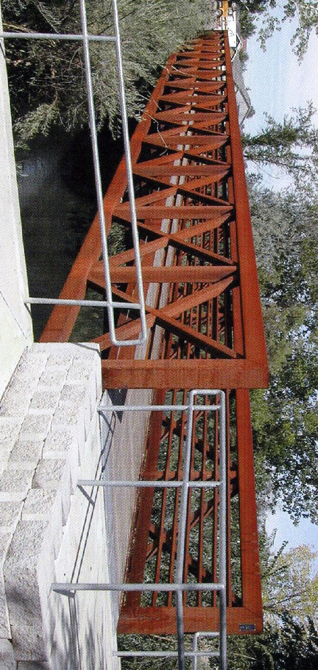
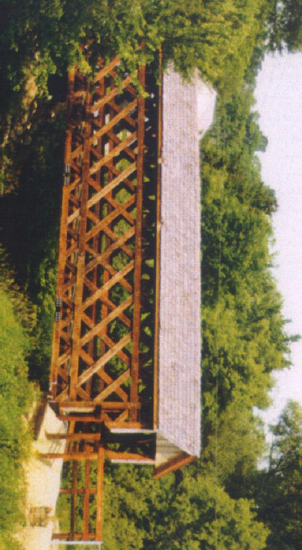
7 2 BRIDGE & TRAIL OPTIONS Planning Process River Planning Group meetings began on January 31, 2006, where the Group reviewed the objectives of the process and discussed project goals for river planning overall. Potential river crossings, pedestrian and bike paths, and other river restoration projects were discussed at the February 23 meeting. A Improvements/Activities for the Yahara River Corridor, as list of potential projects prioritized by the River Planning Committee was distributed to Group Av. members to rank projects Score Improvement / Activity by priority. Project 4.20 New bridge crossing west of 8th in Mandt Park (see map) priorities were discussed at 4.17 Remove fence along Riverside Park the April 6 meeting. The 4.17 Promote alternate trail route along Academy, Church, and Ridge May 1, 2006 meeting was a 4.15 Additional canoe launch (es) 3.84 Dam abandonment joint River Planning 3.60 New bridge crossing at river adjacent to 8th Street (see map) Group and 3.58 Repair/improve existing canoe launch Redevelopment Steering 3.50 Promote alternate trail loop route along Jefferson and 4th Streets Committee meeting. A 2.84 Repair pier protection at and adjacent to railroad bridge presentation on the Promote business-related river activities preferred (of the original 2.58 Acquire property easements for river trail completion 3) potential bridge 2.58 Bike lane / traffic enhancement along Water St. for trail connection locations at Eighth 2.58 New bridge crossing at Dunkirk Park (see map) Street and at Dunkirk Park 2.25 Misc. Comments - close dam - improve access to river was given. The cost 2.17 Stormwater outflow pipe repair and restoration 2.00 Dam repair/rehabilitation for each crossing was 1.86 Riverbank erosion repair projected to be the same, 1.84 Dam island restoration including fishing dock at about $250, Misc. Comments Close Riverside Drive, make into bike path * Each Group member could rank each item on a scale of 1 through 5, with 5 being the most important Bridge Options The River Planning Group recommended Option #3, the Dunkirk Park crossing. Option #3 necessitates working with the School District, since they own some land on the west side of the Yahara River that is needed for the route. The Group felt that the Dunkirk Park location best achieved the goal of connecting the bike and pedestrian trails on the east side of the City with the rest of the trail system. Appendix A contains a map of the 3 bridge options initially considered, and how they relate to other existing and planned trail and river improvements. A bridge design sheet is included on the following page it shows 2 potential bridge Bridge crossing location at 8th Street. 4


8
. A complete sheet of River Improvement Project Construction Costs, which include the proposed bridge, is included in Appendix B.")
9 2 BRIDGE & TRAIL OPTIONS designs (both of which would cost roughly the same amount), along with example pictures of bridge designs. The final cost estimate for the bridge was $275,000 (in 2006 dollars). A complete sheet of River Improvement Project Construction Costs, which include the proposed bridge, is included in Appendix B. The bridge is just one of many trail and river improvement measures that are planned other improvements include dam removal, stream bank restoration, and stormwater management improvements. Trail Options Two trail options from Dunkirk Park north to Bridge crossing location at Dunkirk Park. the Yahara River were explored. One followed the rail right-of-way northwest to connect with the existing pedestrian bridge near the rail bridge across the Yahara. The other was north along Academy Street to Church Street, then west on Ridge Street and north and west on Ridgeway Street, to connect with the same existing pedestrian bridge. The rail line was originally thought to be the best option for this trail; however, after further study and exploration, it was determined that the challenges with steep grades on both sides of the tracks would be too difficult to overcome and the alternate Academy Street route was chosen by the River Planning Group and Rail Corridor Redevelopment Committee. Costs for the Academy route are included as part of Appendix B. The estimated cost from the bridge at Dunkirk Park is $29,000 for a paved trail across Dunkirk Park and painting the bike route on existing City streets. Conclusion The bridge and trail routes planned for in this document are a critical part of the long-term ongoing process of redeveloping Stoughton s rail corridor area. They provide access to recreational opportunities that will be needed if high-quality redevelopment is to be attracted to the area. The trail connections and the Yahara River improvements (see Section 3) comprise a comprehensive approach to ecological restoration and river-related recreation that will reconnect the City with its most prominent natural resource. 6

10 3 FURTHER PLANS DNR River Protection Grant Planning Stoughton s primary goals with this project were to define ways to improve its river environment, promote recreational and business activities on and along the river, and improve the community s understanding of the economic value of the Yahara River. The principal challenge of this project was the need to protect the river ecosystem while promoting increased use of the river. This project recommends economically and ecologically beneficial ways to improve access and use of the river after building public consensus for these activities. The City s water front areas are important to the community. Local residents have demonstrated their support for ecologically sensitive improvements to water front areas that promote increased use if they also provide economic advantages for the City. The role the river plays as an amenity for redevelopment is an example of this. Another goal of this project was to create a coordinated approach to protecting the river by forming a permanent river planning organization. A coordinated long-term approach to river planning will increase the efficiency, and effectiveness of river protection activities. The planning project began by identifying major waterfront areas in Stoughton. Then the project produced maps identifying points of public access to these river front areas. Then the project established a river planning group that included members from the private sector (local business owners, recreational users of the river), and the public sector (local government). The project s river planning group promoted communication and coordination between existing groups that were concerned about river activities in the community. The river planning group discussed river related activities and methods to increase river use while protecting the environment. The City will use the report produced by this grant, in conjunction with its other river planning efforts to decide where to expend limited funds on river front improvements. The City has ample park land along the river and would like to link these lands to downtown businesses and the City s recreational trail system. Areas along the river that need rehabilitation or enhancement, such as the eroding shore line, if modified correctly would also benefit the river ecosystem. Stoughton Yahara River Improvements As is apparent from the map in Appendix A, numerous improvements are planned for the Yahara River as it flows through the City of Stoughton. Dam removal, riverbank erosion repair, stormwater outflow improvements, and canoe launch repair and installation are all part of a comprehensive approach to making the Yahara River more accessible to Stoughton citizens, encouraging redevelopment while also making environmental improvements. The photo on this page and those on the following page show some of the locations of the proposed Proposed trail route along west side of river improvements. fence to be removed. 7


11 3 FURTHER PLANS Stormwater outflow improvement. New boat launch and canoe livery building. Stream bank restoration and pier protection at existing railroad crossing. Proposed trail route Riverside Drive. Riverbank erosion repair needed as well. Dam removal and stream bank restoration. Potential fishing dock on island east of dam. 8

.")
12 3 FURTHER PLANS Stoughton Trails The bridge and trail options outlined in Section 2 are part of a larger plan of trail improvements. Other planned trails to complete the trail loop is a trail from the existing Jefferson Street pedestrian bridge south and then east to 4th Street. This trail would require some easement acquisition along the river. From 4th Street the trail would continue along Mandt Park to the preferred bridge crossing at Dunkirk Park (see Appendix A map). One potential trail not outlined on the map is a trail from 4th Street to Dunkirk Park on the north side of the river. Such a trail could occur as part of the redevelopment of industrial property along the river. Riverside Park stream bank restoration area. Riverside Park canoe launch area. 9


13
14 Subtotal Dam Options $986, Miscellaneous: 1 Shoreline Restoration Along Yahara River from Railroad to Water Street (assume full length divided by each side) LF 2589 $7.50 $19, Boat launch, seasonal ADA portable toilet with enclosure, Parking lot at Riverside Park with Shoreline Restoration LS 1 $15, $15, Boat launch upgrade in Division St. Park LS 1 $2, $2, Storm sewer outfall repairs EA 10 $1, $10, Public gathering/streetscape facilities at end of Jefferson at Pedestrian Bridge (deck, dock, bike parking, etc) LS 1 $5, $5, Improve existing city building in Division St Park to include concession sales LS 1 $20, $20, Livery Building Rehabilitation (foundation repair, building maintenance) LS 1 $15, $15, Major Storm sewer outfall repairs (North Ave and Adjacent to Railroad Bridge) EA 2 $15, $30, Pier Rehabilitation at Railroad Bridge LS 1 $10, $10, New Trees and shrubs (near toe of slope) to replace fencing at Riverside Park LF 500 $35.00 $17, Subtotal Miscellaneous Options $144, TOTAL CONSTRUCTION COST OPTIONS $2,472, Priority 1 High, 5 Low VIERBICHER ASSOCIATES, INC. River Improvement Project Construction Costs - March 23, 2006 City of Stoughton Project Number Construction Cost for year 2006 Item Description Trails 1 Paved Recreational Trail along River parallel to Division St from railroad to North St Measure LF 1552 $39.75 $61, Paint Bike Route on Division, Washington, & Water Streets from North St to Jefferson St. - double line LF 1364 $3.00 $4, A New bridge to replace Existing Pedestrian Bridge & removal of old - Crossing over Yahara River adjacent to Jefferson LS 1 $65, $65, B New Covered Bridge Option to replace existing - Yahara River adjacent to Jefferson LS 1 $150, $150, Paved Recreational Trail along west side of Yahara River From Jefferson to Riverside & Bank Restore (assume easement acquisition) LF 1282 $47.25 $60, Add Trail along edge of Riverside Drive and rip-rapped Shoreline restoration (included additional breaker run base) LF 495 $54.75 $27, Paved Trail to 4th Street with New Bridge or New Pipes in drainage way in Riverside Park (see map) LF 455 $95.00 $43, Paint Bike Route along Jefferson from Water St. to 4th St. Then south on 4th to Mandt Park - double line LF 1953 $3.00 $5, Paved trail along River in Mandt Park to new Bridge including shoreline stabilization (assume full length divided by each side) LF 1632 $54.75 $89, New Bridge from Mandt Park to Dunkirk Park (site 3) LS 1 $275, $275, Paved Trail across Dunkirk Park to Dunkirk Ave LF 360 $39.75 $14, A Paint Bike Route on Academy Avenue from Clay St to Main St. - double line LF 2196 $3.00 $6, B Paint Bike Route on Academy Avenue from Clay St to Veterans Road - double line LF 2165 $3.00 $6, Paint Bike Route along Main from Academy to Church to Ridge to Division to Existing Rail Road Underpass LF 2718 $3.00 $8, Paved trail along railroad from Dunkirk Park to northern trail at the Yahara River including fencing & ramp East South St LF 3471 $60.00 $208, Paved trail along west side of Yahara River from Forton St. north to Yahara River trail along sanitary sewer easement LF 1202 $39.75 $47, New Bridge Across Yahara River from Mandt Park at 8th Street (site 2) LS 1 $250, $250, A Paint Bike Route along 8th St. to South St. - double line LF 711 $3.00 $2, B Paved Bike Trail along East South St. to Rail Road Tracks LF 263 $54.75 $14, C Paint Bike Route along East South St. From Rail Road Tracks to Academy - double line LF 399 $3.00 $1, Subtotal Trail Options $1,341, Dam Site 1 Inspect and Renovate Dam LS 1 $200, $200, Inspect and Renovate Power Generation Building LS 1 $300, $300, Restore Shoreline along dam islands upstream and Downstream from Fourth Street LF 1100 $15.00 $16, ADA Fishing Facility downstream from Fourth St - south side of River LS 1 $20, $20, Remove Dam Water Control Features and abandon power generation capabilities LS 1 $150, $150, Remove Raceway and Power Generation Building LS 1 $300, $300, Units of Estimated Quantity Unit Price Total Amount G:\DATA\COMM.DEV\Stoughton\ River Planning Grant\River Improvement Project Costs.xls
Planning Districts INTRODUCTION
 INTRODUCTION To facilitate detailed examination of development prospects for all areas of the community, Delano has been divided into 14 planning districts. The location of these planning districts is
Potential Green Infrastructure Strategies May 6, 2015 Workshop
 Potential Green Infrastructure Strategies May 6, 2015 Workshop Background The City of Cortland is developing the Tioughnioga Urban Headwaters Green Infrastructure Action Plan with funding from the National
ARISE: The Rock Renaissance Area Redevelopment & Implementation Strategy
 2014 Professional Awards 1 ARISE: The Rock Renaissance Area Redevelopment & Implementation Strategy Janesville, WI Completed December 2014 Analysis & Planning Purpose of Project 2 The purpose of the Rock
Mendota Heights 2040 Comprehensive Plan Draft Vers
 4 Parks and Trails The City of Mendota Heights boasts a variety of recreational and open space opportunities. Few cities can claim access to regional trails, riverside and lakeside parks, scenic bluffs
Promoting Economic Development Through Upfront SEPA Review: Lessons from South Downtown Tacoma
 Promoting Economic Development Through Upfront SEPA Review: Lessons from South Downtown Tacoma 1 This session will focus on the City of Tacoma s South Downtown Subarea Plan and associated Non-Project SEPA
Northwest Rail Corridor and US 36 BRT Development Oriented Transit Analysis 4.4 STATION AREA FINDINGS
 4.4 STATION AREA FINDINGS Each station is different, and each one requires a separate set of recommendations based on the vision for the site. This section outlines an initial TOD strategy and recommendations
& SUSTAINABILITY PLAN
 Chapter 6: IMPLEMENTATION, MANAGEMENT, & SUSTAINABILITY PLAN Overview The Chester Woods Master Plan presents a long-term vision for the park. While phasing of improvements is suggested, Olmsted County
At first Work Session on October 22, At second Work Session on November 19, At third Work Session on December 3, 2015
 At first Work Session on October 22, 2015 Staff Reviewed Infrastructure: Transportation Capacity School Capacity Willett Branch Proposed Staging Language At second Work Session on November 19, 2015 Land
City of Meriden Harbor Brook Flood Control Project Overview
 City of Meriden Harbor Brook Flood Control Project Overview Updated August 2013 OVERVIEW The center of Meriden, including the HUB site is the low point of the town which is ringed by basalt ridges. Running
DRAFT ROOSEVELT ROAD. District Recommendations. Figure 5.23 The Roosevelt Road Corridor
 CHAPTER 5 Figure 5.23 The Road Corridor Road will develop as a mixed-use corridor, emphasizing regional retail, west of the river and mixed-use development east of the river. KEY RECOMMENDATIONS 1. High
The transportation system in a community is an
 7 TRANSPORTATION The transportation system in a community is an important factor contributing to the quality of life of the residents. Without a sound transportation system to bring both goods and patrons
Please read the entire document
 projects impacting the waterfront revitalization area. The waterfront revitalization area of the town will have to subareas to the west and east of the village. Page 6 of 6 Wayfinding master plan create
Enhance the High Line Canal Projects
 Enhance the High Line Canal Projects Joint Project Proposal for Arapahoe County Open Spaces Funding Partner Sponsors: South Suburban Park and Recreation District City of Centennial City of Littleton October
OPPORTUNITIES AND CONSTRAINTS - OXBOW PARK ENTRANCE AND PUT-IN
 OPPORTUNITIES AT OXBOW EXISTING WETLANDS Site is undeveloped and we can design a park that works well from the start. SAND BEACH Potential to eliminate invasive species. DEBRIS (CONCRETE, OLD CARS) VEGETATION
BROOKHILL NEIGHBORHOOD MODEL ZONING MAP AMENDMENT PREFACE TO APPLICATION
 BROOKHILL NEIGHBORHOOD MODEL ZONING MAP AMENDMENT PREFACE TO APPLICATION June 15, 2015 Revised: August 1, 2016 I. VISION Brookhill is a proposed community based upon the principles of Albemarle County
DISCUSSION TOPIC: ST JOHNS RIVER & ITS TRIBUTARIES (BPII) 2030 COMPREHENSIVE PLAN POLICES AND REGULATORY FRAMEWORK
 2030 COMPREHENSIVE PLAN POLICES AND REGULATORY FRAMEWORK") DISCUSSION TOPIC: ST JOHNS RIVER & ITS TRIBUTARIES (BPII) 2030 COMPREHENSIVE PLAN POLICES AND REGULATORY FRAMEWORK St. John s River & Its Tributaries Issue Summary: The St. Johns River is an important
DISCUSSION TOPIC: ST JOHNS RIVER & ITS TRIBUTARIES (BPII) 2030 COMPREHENSIVE PLAN POLICES AND REGULATORY FRAMEWORK St. John s River & Its Tributaries Issue Summary: The St. Johns River is an important
1. Parks & Recreation Neighborhood Parks Community Parks Special Use Sites 2. Open Space 3. Trails
 Appendix A: Park Classifications The intent of parks and recreation classifications is to aid in making acquisition and design decisions for park sites, facilities and the organization of recreation space
Town of Peru Comprehensive Plan Executive Summary
 Town of Peru Comprehensive Plan Executive Communities that plan grow by choice, not by chance. A plan makes growth thoughtful, understandable, and predictable. A plan shows that a community is managing
Great Plans for a Great City
 CHAPTER 1 Great Plans for a Great City 1 Figure 1.1 South Michigan Avenue today Figure 1.2 South Michigan Avenue will be one of many higher intensity, mixed-use corridors that will extend out from the
Pittsfield Action Plan (West Branch of the Housatonic River)
") An initiative of the Massachusetts Executive Office of Energy and Environmental Affairs in partnership with the City of Pittsfield Pittsfield Action Plan (West Branch of the Housatonic River) The spring
An initiative of the Massachusetts Executive Office of Energy and Environmental Affairs in partnership with the City of Pittsfield Pittsfield Action Plan (West Branch of the Housatonic River) The spring
ADOPTED CAPITAL IMPROVEMENT PROGRAM BUDGET ARROYO PROJECTS
 ADOPTED CAPITAL IMPROVEMENT PROGRAM BUDGET ARROYO PROJECTS HAHAMONGNA FY 212-216 Capital Improvement Program Priority Description Total Estimated Costs Appropriated Through FY 211 Adopted FY 212 FY 213
October 25 Downtown Partnership and Action Plan Workshop Record of Group Table Results
 October 25 Downtown Partnership and Action Plan Workshop Record of Group Table Results During the October 25 workshop, participants were asked to rank their top priorities for the Downtown Action Plan.
COMMUNICATION URBAN DESIGN REVIEW BOARD CITY OF DES MOINES, IOWA MAY 16, 2017 MEETING
 COMMUNICATION URBAN DESIGN REVIEW BOARD CITY OF DES MOINES, IOWA MAY 16, 2017 MEETING Subject: Recommendation Prepared by: PRELIMINARY DESIGN REVIEW OF LOCUST STREET BRIDGE CONSTRUCTION & COURT AVENUE,
G. RECREATION AND OPEN SPACE ELEMENT. The following summarizes the Recreation and Open Space Element:
 G. RECREATION AND OPEN SPACE ELEMENT The purpose of the Element is to provide the framework and direction for a comprehensive system of public and private sites for recreation, including, but not limited
Plan Policies. Introduction
 Plan Policies Introduction The purpose of the Plan Policies section is to identify the various Governing Body and Planning Commission land use related policy resolutions for use in evaluating development
Mississippi Skyway Preliminary Engineering Report
 EXECUTIVE SUMMARY Mississippi Skyway Preliminary Engineering Report CITY OF RAMSEY, MINNESOTA DECEMBER 2014 City of RAMSEY EXECUTIVE SUMMARY Project Need and Intent The Mississippi Skyway pedestrian bridge
{Best Practices. Summary of Tools, Strategies and Best Practices from 11 Michigan Case Study Communities
 Case Studies Michigan Coastal Community Working Waterfronts { Summary of Tools, Strategies and from 11 Michigan Case Study Communities Table of Contents Zoning...2 Community and Stakeholder Collaboration
Best Practices Appendix: Waterfront Communities
 Redevelopment Ready Communities Best Practices Appendix: Waterfront Communities revised September 2014 Waterfront RRC defined The purpose of these additional criteria is to provide waterfront communities
7.0 SOCIAL, ECONOMIC, AND ENVIRONMENTAL ISSUES
 7.0 SOCIAL, ECONOMIC, AND ENVIRONMENTAL ISSUES The following list of social, economic, and environmental issues have been identified based on a preliminary inventory of resources in the project area, an
Corridor Vision. 1Pursue Minnehaha-Hiawatha Community Works Project. Mission of Hennepin County Community Works Program
 1Pursue Minnehaha-Hiawatha Community Works Project Minnehaha-Hiawatha Community Works is a project within the Hennepin Community Works (HCW) program. The mission of the HCW program is to enhance how the
Urban runoff in my neighborhood (Capitol Hill) is heavy with trash and other debris.
 is heavy with trash and other debris.") South Platte River Meeting Comments & s #1 I am a huge fan of river areas and would love the Platte and surrounding waterways to improve to allow habitat for wildlife and recreation opportunities for citizens.
South Platte River Meeting Comments & s #1 I am a huge fan of river areas and would love the Platte and surrounding waterways to improve to allow habitat for wildlife and recreation opportunities for citizens.
Keyport. Vision for Keyport
 Keyport Vision for Keyport Keyport is a rural, historic waterfront village bounded and limited in size by its natural borders of water and the Naval Undersea Warfare Center. The community consists primarily
DRAFT. Waterfronts and Open Spaces. 10 The Riverfront Open Space System
 CHAPTER 4 Waterfronts and Open Spaces 10 The Riverfront Open Space System 12 Planned, proposed and envisioned riverfront recommendations. Figure 4.3.23 The riverfront will become a major new public amenity
WILLAMETTE FALLS LEGACY PROJECT
 OPPORTUNITIES & CONSTRAINTS There are here three falls on a line of rocks extending across the river, which forms the bed of the upper channel. The water is precipitated through deep abrazed gorges, and
Pinellas County Greenways
 Pinellas County Greenways USING GREENWAYS TO LINK OPEN SPACES The Florida Greenways Commission has defined a greenway as...a corridor of protected open space that is managed for conservation and/or recreation.
Tyvola & Archdale Transit Station Area Plan. May 15, 2008
 Tyvola & Archdale Transit Station Area Plan First Public Meeting May 15, 2008 Presentation Outline 1. Purpose and Process 2. Station Area Overview 3. Plan Recommendations Vision Land Use Transportation
The Five Components of the McLoughlin Area Plan
 The Five Components of the McLoughlin Area Plan This documents contains the complete language of the five components of the McLoughlin Area Plan: The Vision Statement The Values The Guiding Principles
West London Dyke, April 1947 Flood. Forks of the Thames, July 2000 Flood. Source: UTRCA
 This Public Information Centre is the 1 st of 2. Its purpose is to inform the public and to receive input with regards to the West London Dyke Master Repair Plan. The following panels describe the history,
New Partners for Smart Growth Conference February 5, 2010
 Dan Stroh, Planning Director City of Bellevue Planning and Community Development Bellevue, WA New Partners for Smart Growth Conference February 5, 2010 Summary of Project Long-range plan update for Bel-Red
Highland Falls Waterfront Redevelopment Feasibility Study Village Board Meeting March 20, 2017
 Village Board Meeting March 20, 2017 Agenda I. Public Meeting #1 Visioning Summary II. Public Meeting #2 Comment Summary III. IV. IV. Case Study: Milton Train Station Schematic Design Concepts Schedule/Next
Below the trestle lie artifacts of past industry along the Cobbossee Stream. South end of the trestle, at the proposed trailhead area.
 The existing railroad trestle, when refitted as a pedestrian walkway, could be an important, eye-catching, scenic component to the Cobbossee Stream Trail. South end of the trestle, at the proposed trailhead
Review of Opportunity Area C Draft Comprehensive Plan and Draft BOS Follow-On Motions. Special Working Group Meeting March 4, 2015
 Review of Opportunity Area C Draft Comprehensive Plan and Draft BOS Follow-On Motions Special Working Group Meeting March 4, 2015 The slides that follow identify where the draft Comprehensive Plan has
CHAPTER 8 ISSUES, CONCERNS, CONSTRAINTS AND OPPORTUNITIES
 CHAPTER 8 ISSUES, CONCERNS, CONSTRAINTS AND OPPORTUNITIES Introduction This River Conservation Plan was developed during a time of tremendous activity and effort in planning the transformation of the Delaware
PARTF Scoring System for Grants
 PARTF Scoring System for Grants The members of the N.C. Parks and Recreation Authority use the PARTF scoring system as one of several tools to select grant recipients. Please provide all of the information
Dequindre Cut Greenway Phase II North Strategic Plan. Executive Summary
 Dequindre Cut Greenway Phase II North Strategic Plan Executive Summary May 2009 Report prepared for: Economic Development Corporation of the City of Detroit Report funded by: Community Foundation for Southeastern
City of Toronto. Emery Village Transportation Master Plan
 City of Toronto Emery Village Transportation Master Plan May 2009 Emery Village Transportation Master Plan Toronto, ON May 2009 Consulting Inc. 100 York Blvd., Suite 300 Richmond Hill, ON L4B 1J8 Tel:
Capital Projects in and near Odenton Town Center
 Capital Projects in and near Odenton Town Center Map ID Anne Arundel County Department of Public Works This project provides for the design, right of way acquisition, and construction of approximately
Whittier Greenway Trail. Est. 2009
 Whittier Greenway Trail Est. 2009 The Whittier Greenway Trail begins in the northwest corner of Whittier, near the 605 Freeway, and closely parallels Whittier Boulevard. When it reaches Painter Avenue,
Garver Feed Mill Timeline
 Garver Feed Mill Timeline 1) 1989 Garver Feed Mill is designated as a CDA Redevelopment Project 2) 1991 Olbrich Botanical Gardens opens Bolz Conservatory, Schumacher Library, and associated buildings 3)
3. VISION AND GOALS. Vision Statement. Goals, Objectives and Policies
 Vision Statement Queen Creek s interconnected network of parks, trails, open spaces and recreation opportunities provide safe and diverse activities and programs that sustain its unique, small town, equestrian
Capital Projects impacting Odenton Town Center
 Capital Projects impacting Odenton Town Center 1 2 E549700 W801600/ W801602 Anne Arundel County Department of Public Works Manor View Elementary School Transmission Main - MD 32 @ Meade Phase 2 $34,399,000
Section 4 BUILDING THE MASTER PLAN
 The Master Plan 33 Section 4 BUILDING THE MASTER PLAN Figure 4:1. A collaborative effort characterized the two design workshops sponsored by DISC to create hypothetical Master Plans for the Towers Property
A larger version of this map is located on the last page of this PDF.
 MAP Committee Input McLoughlin Area Draft Vision Map A larger version of this map is located on the last page of this PDF. 1. The map above is intended to portray a vision for the McLoughlin area. It highlights
Complete and Green Streets
 Complete and Green Streets DANNIELLE GLAROS CHIEF OF STAFF, COUNCILMAN ERIC OLSON JIM WILSON DEPARTMENT OF PUBLIC WORKS AND TRANSPORTATION, PRINCE GEORGE S COUNTY What is a complete street? Complete streets
DOMINION BOULEVARD CORRIDOR STUDY AND ECONOMIC DEVELOPMENT STRATEGIC PLAN A MODEL FOR CHESAPEAKE S FUTURE
 DOMINION BOULEVARD CORRIDOR STUDY AND ECONOMIC DEVELOPMENT STRATEGIC PLAN A MODEL FOR CHESAPEAKE S FUTURE Overview I. Draft Plan Process II. Draft Plan Overview a. Market Analysis b. Master Land Use Plan
Arkansas River Corridor
 Planning for Access Welcome to the Access Project. This project is a recreational planning effort in response to an interest by regional communities along the Arkansas River corridor. The project plan
The City shall enhance and improve the accessibility of parks and recreational facilities while protecting their quality. by:
 GOALS, OBJECTIVES AND POLICIES GOAL 1: To provide open space and recreation as an essential element needed for the betterment of the City s character and quality of urban life. The City shall plan for
LAND USE PLAN 7. Housing
 21 LAND USE PLAN While the land uses that have historically dominated the Corridor itself have been industrial/commercial, the Master Plan proposes a shift to mixed-use redevelopment, complimented by a
Chapter 10 IMPLEMENTATION RECOMMENDATIONS
 Chapter 10 IMPLEMENTATION RECOMMENDATIONS The recommended land use plan presented in the previous chapter provides a design for the attainment of the urban and rural development and open space preservation
Reconnecting to a Forgotten River St. Cloud MN. Aaron Hanson Design Design Thesis LA 572, Thesis, Spring 2012
 Reconnecting to a Forgotten River St. Cloud MN Aaron Hanson Design Design Thesis LA 572, Thesis, Spring 2012 site context 2.5 Miles Sartell St. Cloud to Fargo 170 Miles (2 hrs 45 mins) Hwy 10 infrastructure
HURON WATERFRONT DEVELOPMENT AND AMPHITHEATER
 AWARD WINNING PROJECT Location Huron, Ohio Architectural, Engineering, Site, Landscaping, Planning, Survey, Grant Administration, Construction Administration Cost $285,000 Amphitheater $300,000 Marina
North Shore Trail. Council Meeting June 10, 2002
 North Shore Trail Council Meeting June 10, 2002 Process Guiding Principles Inventory and Analysis Preliminary Concepts (4) Final Concept Phasing Strategy Estimated Costs OVERVIEW Purpose: Prepare an overall
-- MEETING SUMMARY-- 39 th Ave. Greenway Design Workgroup Meeting #9 February 13, :30 7:30 p.m.
 Meeting Purpose -- MEETING SUMMARY-- 39 th Ave. Greenway Design Workgroup Meeting #9 February 13, 2018 5:30 7:30 p.m. Introduce SEMA Construction design-build team Provide overview and gather input on
Carolina Tread Trail Corridor Feasibility Study
 DRAFT Town of Mooresville Carolina Tread Trail Corridor Feasibility Study July 2012 table of contents 5 acknowledgements 7 summary of process 9 community involvement 10 alternative alignment analysis
Stakeholders Advisory Working Groups (SAWGs) Smart Growth and TOD Land Use (#11) SAWG Meeting
 Smart Growth and TOD Land Use (#11) SAWG Meeting") Presentation - Part II Tappan Zee Bridge/I-287 Corridor Project July 21, 2010 Slide 1. David Kooris (Regional Plan Association) welcomed members of the Land Use Stakeholders Advisory Working Groups (SAWGs)
Presentation - Part II Tappan Zee Bridge/I-287 Corridor Project July 21, 2010 Slide 1. David Kooris (Regional Plan Association) welcomed members of the Land Use Stakeholders Advisory Working Groups (SAWGs)
An Ambitious Plan: Transforming the blighted South Platte River and surrounding environment into Denver s greatest natural resource.
 CONNECTING THE PEOPLE TO THEIR RIVER SOUTH PLATTE RIVER VISION IMPLEMENTATION PROGRAM: GRANT-FRONTIER PARK TO OVERLAND POND PARK REACH The South Platte River Vision Implementation Program (River Vision)
APPENDIX K WINDSOR OFFICIAL PLAN
 CEAA ENVIRONMENTAL ENVIRONMENTAL IMPACT ASSESSMENT AMBASSADOR BRIDGE ENHANCEMENT PROJECT Replacement Span and Plaza Expansion APPENDIX K WINDSOR OFFICIAL PLAN Avalon Consulting Professionals of Ontario,
To: Planning Commission D.. June 3, 2009
 Agenda Item No. 9(a~ CITY OF WOODINVILLE, WA REPORT TO THE PLANNING COMMIS ION 17301 133 1'd Avenue NE, Woodinville, WA 98072 WWW.CI.WOODINVILLE.WA.US To: Planning Commission D.. June 3, 2009 From: Subject:
Riverwalk Dreams compiled by Thomas P. Healy November 16, 2017
 Riverwalk Dreams compiled by Thomas P. Healy November 16, 2017 1986 Ripple Village Plan: A neighborhood plan developed by the City of Indianapolis Department of Metropolitan Development s Division of Planning
DRAFT SECTION 4(F) EVALUATION STILLWATER MUNICIPAL BARGE FACILITY
 EVALUATION STILLWATER MUNICIPAL BARGE FACILITY") DRAFT SECTION 4(F) EVALUATION I. DESCRIPTION OF SECTION 4(F) RESOURCE The Section 4(f) resource discussed in this evaluation is known as the Stillwater Municipal Barge Facility property, known previously
DRAFT SECTION 4(F) EVALUATION I. DESCRIPTION OF SECTION 4(F) RESOURCE The Section 4(f) resource discussed in this evaluation is known as the Stillwater Municipal Barge Facility property, known previously
Rural Land Use Designations Kittitas County December 6, 2007 Draft
 KITTITAS COUNTY COMMUNITY DEVELOPMENT SERVICES 411 N. Ruby St., Suite 2, Ellensburg, WA 98926 CDS@CO.KITTITAS.WA.US Office (509) 962-7506 Fax (509) 962-7682 Rural Land Use Designations Kittitas County
ENBRIDGE GAS DISTRIBUTION INC. Proposed Relocation for Ninth Line, Markham and Whitchurch-Stouffville. Environmental Screening Report
 Page 1 of 18 ENBRIDGE GAS DISTRIBUTION INC. Proposed Relocation for Ninth Line, Markham and Whitchurch-Stouffville Environmental Screening Report July 2011 Page 2 of 18 Table of Contents 1.0 INTRODUCTION
A BLUEPRINT FOR BROCKTON A CITY-WIDE COMPREHENSIVE PLAN
 A BLUEPRINT FOR BROCKTON A CITY-WIDE COMPREHENSIVE PLAN Public Meeting October 2016 1 Plan Summary and Discussion Public Meeting May 4 2017 City of Brockton Bill Carpenter, Mayor Department of Planning
EXHIBIT A. Tax Increment Reinvestment Zone No. 1 (Town Center) First Amended Project Plan 1
 First Amended Project Plan 1") EXHIBIT A Tax Increment Reinvestment Zone No. 1 (Town Center) First Amended Project Plan 1 1 As amended by Resolution No. 2008-02-001(TR1R) of the Tax Increment Reinvestment Zone No.1, and approved to
EXHIBIT A Tax Increment Reinvestment Zone No. 1 (Town Center) First Amended Project Plan 1 1 As amended by Resolution No. 2008-02-001(TR1R) of the Tax Increment Reinvestment Zone No.1, and approved to
This Review Is Divided Into Two Phases:
 Semiahmoo Town Centre Review The purpose of this review: To review the Semiahmoo Town Centre Concept Plan, originally approved in 1993, to ensure that this centre will continue to serve the needs of South
The following principles guide the development of goals and strategies to protect and promote these amenities:
 OPEN SPACE/PARKS/TRAILS/RECREATION GOALS/STRATEGIES Cherry Hills Village is a living environment that offers low density development, open areas, public scenic vistas, public trails and public parks. This
Reconnecting New Haven: Downtown Crossing
 Reconnecting New Haven: Downtown Crossing Phase 2 Update Introduction to Phase 3 November 16, 2017 City of New Haven, Connecticut Toni N. Harp, Mayor Reconnecting New Haven Introduction Project Overview
Long Branch-Wayne Local Park Renovation Project
 Montgomery Parks Long Branch-Wayne Local Park Renovation Project Community Meeting #2 September 20, 2016 Oak View Elementary School 7:00-9:00 PM Welcome / Team Introductions M-NCPPC (Montgomery Parks)
12 th Street Connector Alignment Study VISIONING PUBLIC WORKSHOP - JUNE 25, :00PM TO 8:00PM
 12 th Street Connector Alignment Study VISIONING PUBLIC WORKSHOP - JUNE 25, 2018 6:00PM TO 8:00PM Goals for Today s Workshop Agenda: Project Introduction, Purpose, and Goals Existing Conditions Traffic
38 Queen s University Campus Master Plan Part 1
 38 Queen s University Campus Master Plan Part 1 46 The Campus at the City Scale Chapter 4 The Campus at the City Scale 39 Queen s is an urban University centrally located in Kingston. Decisions made by
IMPLEMENTATION STRATEGIES. In This Chapter. Goals & Strategies 182 Project List 183 Future Land Use 186 CHAPTER 11 IMPLEMENTATION STRATEGIES
 In This Chapter Goals & Strategies 182 Project List 183 Future Land Use 186 11 IMPLEMENTATION STRATEGIES NORTH AUGUSTA, SC 2017 COMPREHENSIVE PLAN 179 Individual commitment to a group effort that is what
The Mobile Peninsula Corridor Master Plan Dauphin Island Parkway I 10 to Dog River
 The Mobile Peninsula Corridor Master Plan Dauphin Island Parkway I 10 to Dog River Welcome and Introductions Alice Keel Co Founder Prayer Rev. Jim Langston Fulton Road Baptist Church Comments Stewart Hanley,
Putting the Pieces Together
 Putting the Pieces Together A guided tour of the St Croix Valley's land and water resources A Guided View from the River: What are the challenges and obstacles your community is facing? 1 Site 2 Buk and
Chapter 3. Community Vision and Goals
 Chapter 3. Community Vision and Goals 3.1 Public Involvement Charlevoix s master plan was prepared in a way that maximized public participation. Dating back to 2004, the Planning Commission and staff held
Small Area Plan. South Gateway
 Small Area Plan Adopted May 12, 2008 South Gateway Purpose. The South Gateway Small Area Plan defines the City s expectations for the future of the southern entrance to the City at Interstate 85 and Highway
RECREATION, OPEN SPACE AND GREENWAYS ELEMENT GOALS, OBJECTIVES, AND POLICIES
 RECREATION, OPEN SPACE AND GREENWAYS ELEMENT GOALS, OBJECTIVES, AND POLICIES GOAL R-1: DEVELOP A RECREATION, OPEN SPACE AND GREENWAYS SYSTEM AS AN INTEGRAL COMPONENT OF AN OVERALL, COUNTY-WIDE ECONOMIC
OVERVIEW OF PLANS FOR THE JEFFERSON COUNTY COUNTRYSIDE FARM In the Context of Quality Place Characteristics
 OVERVIEW OF PLANS FOR THE JEFFERSON COUNTY COUNTRYSIDE FARM In the Context of Quality Place Characteristics By Steve Grabow, Professor and Community Development Educator University of Wisconsin-Extension,
LPC Goals and Strategies. Transportation and Connectivity Employment Opportunities Food Access Waterfront Access Livable Communities
 LPC Goals and Transportation and Connectivity Employment Opportunities Food Access Waterfront Access Livable Communities Transportation and Connectivity Goal: Safe and ready access of all types allowing
& SUSTAINABILITY PLAN
 Chapter 6: IMPLEMENTATION, MANAGEMENT, & SUSTAINABILITY PLAN Overview The Oxbow Park and Zollman Zoo Master Plan presents a long-term vision for the park. While phasing of improvements is suggested, Olmsted
Kinzie Industrial Corridor
 Mayor Emanuel s Industrial Corridor Modernization Kinzie Industrial Corridor Fulton Market Innovation District Plan Implementation October 10, 2017 Rahm Emanuel, Mayor David Reifman, Commissioner Dept.
Mid-America Regional Council wishes to extend a special thank you to. each of the project participants. This document is the product of the
 ACKNOWLEDGEMENTS Mid-America Regional Council wishes to extend a special thank you to each of the project participants. This document is the product of the combined effort of interested citizens, local
We are a determined group residents, industry, and government and by working together an incredible future lies ahead for Troy.
 PROPOSED EDITS TO COMPREHENSIVE PLAN April 5, 2018 Page Par Change Iv TOC Principle 2, page number is 3 should be 33 I Forward Par 3, delete Strike through: Troy is today experiencing 3 1.1 Par 3 change
Today Land & People. Northeast Nampa Gateway District. Employment. Land Use Characteristics. Demographics. Current Zoning
 Today Land & People Employment Major employers include Saint Alphonsus, the College of Western Idaho, the Auto Mall, Sorrento Lactalis and Walmart. 3,004 jobs in 2010 (COMPASS-CIM 2040 TAZ data) 4,345
Chapter 11. Implementation Plan
 Chapter 11 Implementation Plan 127 D O W N T O W N T AV A R E S R E D E V E L O P ME N T MA S T E R P L A N IMPLEMENTATION PLAN This section shows how the Master Plan translates to a phased series of
FOSTER COMPREHENSIVE PLAN UPDATE CIRCULATION
 5.8.1 INTRODUCTION CIRCULATION The Circulation Element of the Comprehensive Plan studies the routes and modes of travel. The circulation network of the town affects the ease of movement through Foster
RESOLUTION NUMBER Kitsap County Public Works Stormwater Division Six-Year Capital Facilities Plan
 RESOLUTION NUMBER Kitsap County Public Works Stormwater Division Six-Year Capital Facilities Plan WHEREAS, in compliance with Kitsap County Code Chapter 12.36, the Kitsap County Department of Public Works
WELCOME TO OPEN HOUSE TWO November 28, 2018
 Langstaff Road Weston Road to Highway 7 Class Environmental Assessment Study WELCOME TO OPEN HOUSE TWO November 28, 2018 Please sign in and join our mailing list Study Overview York Region is conducting
Chapter 9 Community Facilities & Services Plan. Introduction. Cooperative Efforts. Monitoring of Needs
 Chapter 9 Community Facilities & Services Plan Introduction The location of key community facilities such as water, sewer, schools, parks, and roads is important to the provision of the necessary services
Implementation Guide Comprehensive Plan City of Allen
 Implementation Guide 2030 Comprehensive Plan City of Allen DRAFT 2015 Implementation Guide Allen 2030 Comprehensive Plan INTRODUCTION The Comprehensive Plan serves as a guide for the growth and development
Billing Code: DEPARTMENT OF HOUSING AND URBAN DEVELOPMENT [Docket No. FR-6072-N-01]
![Billing Code: DEPARTMENT OF HOUSING AND URBAN DEVELOPMENT [Docket No. FR-6072-N-01]](/thumbs/91/107309814.jpg "Billing Code: DEPARTMENT OF HOUSING AND URBAN DEVELOPMENT [Docket No. FR-6072-N-01]") This document is scheduled to be published in the Federal Register on 12/18/2017 and available online at https://federalregister.gov/d/2017-27194, and on FDsys.gov Billing Code: 4210-67 DEPARTMENT OF HOUSING
This document is scheduled to be published in the Federal Register on 12/18/2017 and available online at https://federalregister.gov/d/2017-27194, and on FDsys.gov Billing Code: 4210-67 DEPARTMENT OF HOUSING