Hays County Candidate Projects PROPOSED ROAD BOND PROGRAM WORKSESSION
|
|
|
- Kenneth Walton
- 5 years ago
- Views:
Transcription

1 Hays County Candidate Projects PROPOSED ROAD BOND PROGRAM WORKSESSION July 19, 2016 Candidate Projects Identified by Commissioners Complete projects currently in the planning process Priority projects in Hays County Long Range Transportation Plan Project scope ranges from planning and right of way preservation to full design and construction July 19,
2 Types of Projects Address congestion/mobility Improve regional connectivity Safety and operations Support economic development Corridor preservation Leverage TxDOT/local dollars July 19, Cost Estimates Prepared by local engineering firms Current (2016) construction cost Right of way based on land values near project 15% miscellaneous construction 20% contingency 15% 20% professional services Environmental Legal CEI All estimates reviewed for reasonableness by HNTB and HDR July 19,


3 Insert map 11 x 17 color Precinct lines All projects July 19, Potential Projects List Project HAYS COUNTY 2016 POTENTIAL ROAD BOND PROJECTS Project Limits Budget PRECINCT 1 1 SH 21 Corridor US 183 / SH 45 SH 80 $ 24,600,000 2 SH Bogie Rd/Arnold Ave 500' West 500' East $ 500,000 3 SH FM ' West 500' East $ 800,000 4 Posey Road Expansion CR 266 Hunter Road $ 19,700,000 5 Posey Road Extension CR 266 SH 123 $ 1,900,000 6 Harris Hill Extension End River Ridge Pkwy $ 30,600,000 7 Centerpoint Road Reconstruction Old Bastrop Road County Line $ 16,600,000 8 SH Military 500' North of Military 500' South of Military $ 1,000,000 9 FM River Hills Dr 500' North 500' South $ 1,700, FM Crystal River 500' North 500' South $ 800, Beback Inn Road Centerpoint Road SH 123 $ 6,200, Beebee Road Safety Improvements & ROW I 35 Goforth Road $ 3,100,000 Precinct 1 Total $ 107,500,000 July 19,
4 Potential Projects List Project HAYS COUNTY 2016 POTENTIAL ROAD BOND PROJECTS Project Limits Budget PRECINCT 2 1 FM 2001 Gap East of White Wing Trail West of Rhode Road $ 9,100,000 2 Robert S Light Ext / Buda Truck Bypass ROW RM 967 FM 1626 $ 6,200,000 3 Dacy Lane Beebee Road Hillside Terrace $ 36,500,000 4 RM 967 Railroad I 35 $ 11,600,000 5 SH Grist Mill Rd 500' West 500' East $ 1,000,000 6 SH Cotton Gin Rd 500' West 500' East $ 1,100,000 7 Kyle/Mountain City Loop RM 150 FM 1626 $ 12,000,000 8 RM 967 Safety Turn Lanes West of FM 1626 $ 5,900, Windy Hill Road I 35 FM 2001 $ 21,600,000 9 Hillside Terrace Safety Improvements & ROW I 35 FM 2001 $ 2,600, South Turnersville Road County Line FM 2001 $ 1,400, FM Hays Youth Baseball/Softball/Soccer & 4H Barns FM ' East of Hays Youth $ 1,800, Lois Lane Dacy Lane Marsh Lane $ 1,000,000 Precinct 2 Total $ 111,800,000 July 19, Potential Projects List Project HAYS COUNTY 2016 POTENTIAL ROAD BOND PROJECTS Project Limits Budget PRECINCT 3 1 Centerpoint Road Extension Hunter Road RM 12 $ 10,800,000 2 Centerpoint Road Expansion I 35 Hunter Road $ 5,400,000 4 FM 3237 Safety Improvements RM 12 RM 150 $ 14,000,000 3 McCarty Expansion I 35 Hunter Road $ 6,000,000 5 Winters RM ' West 500' East $ 400,000 6 Winters RM ' North 500' South $ 600,000 Precinct 3 Total $ 37,200,000 PRECINCT 4 1 FM 150 West Realignment ROW & Utilities FM 2770 I 35 $ 11,800,000 2 FM 150 Far West Extension RM 12 US 290 $ 34,100,000 3 US 290 West Safety Improvements McGregor Lane County Line $ 4,000,000 4 Darden Hill Widening Turn Lanes West of Sawyer Ranch RM 1826 $ 7,100,000 5 Old Stagecoach Road Widening RM 150 Post Road $ 15,400,000 6 Post Road High Bridge $ 8,700,000 Precinct 4 Total $ 81,100,000 July 19,
5 Potential Projects List HAYS COUNTY 2016 POTENTIAL ROAD BOND PROJECTS Project Project Limits Budget PRECINCT 1 Precinct 1 Total $ 107,500,000 PRECINCT 2 Precinct 2 Total $ 111,800,000 PRECINCT 3 Precinct 3 Total $ 37,200,000 PRECINCT 4 Precinct 4 Total $ 81,100,000 COUNTY WIDE BUCKETS 1 Drainage / Low Water Crossings Safety Improvements County wide $ 5,000,000 2 Environmental Mitigation RHCP County wide $ 5,000,000 3 Non Motorized Transportation Hike & Bike County wide $ 5,000,000 TOTAL $ 352,600,000 July 19, Project Information Precinct 1 July 19,
6 SH 21 Corridor US 183/SH 45 to SH 80 Plan 4 lane divided in Ultimate ROW Planning TxDOT ENV Clearance ROW Preservation $24.6 M* SH 21 Intersection Safety Improvements At Bogie Road/Arnold Ave $0.5 M At FM 1966 $0.8 M *Costs are for identified tasks proposed for road bond program and do not necessarily indicate total project development and construction costs. July 19, Posey Road Expansion CR 266 to Hunter Road Construct 4 lanes divided in Ultimate ROW Utility Relocation $19.7 M Posey Road Extension CR 266 to SH 123 Plan 4 lane divided in Ultimate ROW Planning ROW Preservation $1.9 M July 19,
7 Harris Hill Extension To River Ridge Parkway Construct interim 2 lanes of 4 lane section in Ultimate ROW $ 30.6 M Centerpoint Road Reconstruction Old Bastrop Road to County Line Construct 4 lanes in Ultimate ROW $16.6 M July 19, SH 80 Intersection Safety Improvements At Military $1.0 M FM 621 Intersection Safety Improvements At River Hills $1.7 M At Crystal River $0.8 M Beback Inn Road Centerpoint Road to SH 123 Add 8 shoulders and overlay in Ultimate ROW $6.2 M July 19,
8 Bebee Road Safety & ROW I 35 to Goforth Road Plan 3 lanes in Ultimate ROW with interim improvements Planning ROW Preservation Safety Design Construct Safety Impr. $3.1 M July 19, Project Information Precinct 2 July 19,
9 FM 2001 Gap East of White Wing to West of Rhode Road 4 lane divided in Ultimate ROW $9.0 M Buda Truck Bypass / Robert S. Light ROW RM 967 to FM 1626 ROW (if not donated) $6.0 M July 19, Dacy Lane Bebee Rd to Hillside Terrace Construct 3 lanes in Ultimate ROW $36.5 M RM 967 Railroad to I 35 Construct 3 lanes in Ultimate ROW TxDOT ENV Clearance $11.6 M July 19,
10 SH 21 Intersection Safety Improvements At Gristmill $1.0 M At Cotton Gin $1.1 M Kyle/Mountain City Loop RM 150 to FM 1626 Plan 4 lane divided in Ultimate ROW Planning ROW Preservation $12.0 M July 19, RM 967 Safety Turn Lanes West of FM 1626 TxDOT ENV Clearance $5.9 M Windy Hill Road I 35 to FM 2001 Construct 3 lanes in Ultimate ROW $21.6 M July 19,
11 Hillside Terrace Safety Improvements & ROW I 35 to FM 2001 Plan 3 lanes in Ultimate ROW with interim improvements Planning ROW Preservation Safety Design Construct Safety Impr. $2.6 M South Turnersville Road County Line to FM 2001 Plan 3 lanes in Ultimate ROW $1.4 M July 19, FM 2770 Intersection Safety Improvement Project At Hays Youth Baseball/Softball /Soccer Complex and 4H Barns $1.8 M Lois Lane Dacy Lane to Marsh Lane Construct 2 lanes in new ROW $1.0M July 19,
12 Project Information Precinct 3 July 19, Centerpoint Road Extension Hunter Road to RM 12 Plan 4 lanes in Ultimate ROW Planning ROW Preservation $ 10.8 M Centerpoint Road Expansion I 35 to Hunter Road Construct 4 lanes in Ultimate ROW $5.4 M July 19,
13 FM 3237 Safety Improvements (Center & Right Turn Lanes) RM 12 to RM 150 TxDOT ENV Clearance $14.0 M McCarty Lane Expansion I 35 to Hunter Road Construct 4 lanes in Ultimate ROW Planning ROW Preservation $6.0 M July 19, Winters Mill Intersection Safety Improvement Projects At RM 3237 $0.4 M At RM 12 $0.6 M July 19,
14 Project Information Precinct 4 July 19, RM 150 West Realignment ROW & Utilities FM 2770 to I 35 & Utility Relocations for Construction ROW Mapping $11.8 M RM 150 Far West Extension RM 12 to US 290 West Construct 4 lane divided in Ultimate ROW Planning Phased Construction $34.1 M July 19,
15 US 290 West Intersection Safety Improvements McGregor to County Line Improve 4 intersections TxDOT ENV Clearance ROW Clips $4.0 M Darden Hill Widening & Turn Lanes West of Sawyer Ranch Road to FM 1826 Construct 3 lanes with turn lanes in Ultimate ROW $18.5M July 19, Old Stagecoach Road Widening RM 150 to Post Road Widen to 28 section $15.4 M Post Road High Bridge Construct new bridge and approaches Planning $8.7 M July 19,
16 Countywide Projects July 19, Drainage/Low Water Crossings/Safety Improvements Bucket Countywide County Roads Off System Bridges $5.0 M Environmental Mitigation (Habitat/Protection) Bucket Acquire Bird Habitat Aquifer Protection $5.0 M July 19,


17 Non Motorized Transportation Bucket Hike & Bike Trails $5.0 M TxDOT Partnership/Leverage Projects to be Determined Includes I 35 Improvements $ TBD July 19, TxDOT 2017 UTP and HB 20 Implementation Source: TxDOT 17


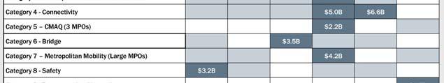
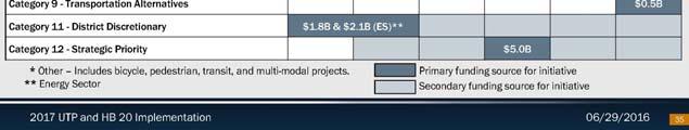
18 TxDOT 2017 UTP and HB 20 Implementation Source: TxDOT TxDOT 2017 UTP and HB 20 Implementation Source: TxDOT 18


 July 19,")


19 TxDOT 2017 UTP and HB 20 Implementation Source: TxDOT (highlighting added) July 19, TxDOT 2017 UTP and HB 20 Implementation Source: TxDOT (highlighting added) July 19,
20 Summary & Next Steps July 19,
SH 199 Corridor Master Plan. Community Meeting No. 2 May 31, 2017
 Community Meeting No. 2 May 31, 2017 Transportation Projects On or Near SH 199 SH 199 from 0.3 miles south of FM 1886 to south end of Lake Worth bridge Construct freeway mainlanes and frontage roads 10-Year
Regional Mobility & the US 380 Bypass Concept. Informational Meeting February 9, 2017
 Regional Mobility & the US 380 Bypass Concept Informational Meeting February 9, 2017 Purpose and Agenda Purpose: Regional Mobility Issues, Priorities, and Pressures US 380 as a Limited Access Facility
2040 Long Range Transportation Plan
 2040 Long Range Transportation Plan Adopted: April 15, 2013 APPENDIX D HIGHWAY NEEDS PLAN PROJECTS FREDERICKSBURG Existing and Committed Projects Fall Hill Avenue/Mary Washington Blvd. (Fredericksburg)
Scope of Services. River Oaks Boulevard (SH 183) Corridor Master Plan
 Corridor Master Plan") Scope of Services River Oaks Boulevard (SH 183) Corridor Master Plan PROJECT AREA The project area consists of the River Oaks Boulevard (SH 183) corridor bounded by SH 199 at the northern end and the Trinity
Scope of Services River Oaks Boulevard (SH 183) Corridor Master Plan PROJECT AREA The project area consists of the River Oaks Boulevard (SH 183) corridor bounded by SH 199 at the northern end and the Trinity
2018 Primary Road Capital Improvement Plan (CIP) Projects Preservation / Structural Improvement, Non-motorized and Engineering Design Projects
 Projects Preservation / Structural Improvement, Non-motorized and Engineering Design Projects") 2018 Primary Road Capital Improvement Plan (CIP) Projects Preservation / Structural Improvement, Non-motorized and Engineering Design Projects Preservation / Structural Improvement Projects in 2018 Ravine
2018 Primary Road Capital Improvement Plan (CIP) Projects Preservation / Structural Improvement, Non-motorized and Engineering Design Projects Preservation / Structural Improvement Projects in 2018 Ravine
COLLIER BOULEVARD (CR 951) CORRIDOR
 CORRIDOR") Project(s) Goals Improve Traffic Circulation, Capacity & Safety Focus on Safety During Design & Construction Address Public Concerns Design an Aesthetically Pleasing Project Limit Environmental Impacts
Project(s) Goals Improve Traffic Circulation, Capacity & Safety Focus on Safety During Design & Construction Address Public Concerns Design an Aesthetically Pleasing Project Limit Environmental Impacts
2017 General Obligation Bond
 2017 General Obligation Bond Presentation of Public and Council Projects to the Transportation & Mobility Stakeholder Committee April 13, 2017 Agenda Deferred Maintenance Project Development Process Projects
Commissioners Road West Realignment Environmental Assessment
 City of London Commissioners Road West Realignment Environmental Assessment Public Information Centre No. 2 November 29, 2017 Welcome to the Public Information Centre This 2 nd Public Information Centre
Transportation Projects Quarterly Report. Morrisville Planning Department May 22, 2018
 Transportation Projects Quarterly Report Morrisville Planning Department May 22, 2018 Transportation Improvements Most Common Ways the Town secures transportation improvements: 1. Development 2. Grant
Places29: List of Implementation Projects
 Important Points to Keep in Mind When Using This List Places29: List of s Each of the projects in this List represents an action needed to implement the Places29 Master Plan. The projects are grouped first
SAWYER RANCH ROAD Pedestrian and Bicycle Improvements
 SAWYER RANCH ROAD Pedestrian and Bicycle Improvements RM 150: From West of Kyle to I-35 Oct. 25, 2018 Thank you for your interest in the RM 150 project. The purpose of this meeting is to share project
Memorandum CITY OF DALLAS. Riverfront Boulevard Design From Continental Avenue to Cadiz Street
 Memorandum DATE November 10, 2011 CITY OF DALLAS TO Trinity River Corridor Project Committee Members: Vonciel Jones Hill (Chair) Linda Koop (Vice Chair), Monica Alonzo, Scott Griggs, Angela Hunt, and Delia
Blake C. Kronkosky, PE, Ph.D.
 Blake C. Kronkosky, PE, Ph.D. Blake.Kronkosky@statetecheng.com, CELL (512) 663-1954 Education Ph.D., Civil Engineering, Texas Tech University, May 2018: An Engineer's Guide for Estimating 1-Day, 100-Year
BEST PRACTICES FOR PROJECT NOMINATIONS TA Set-Aside Program
 BEST PRACTICES FOR PROJECT NOMINATIONS 2017 TA Set-Aside Program Focus of this presentation Photos Public Support Maps & Exhibits Proposed Budget Design Details Project Evaluation & Selection Criteria
Hunt Highway CELESTE PEMBERTON, CFM, CPM PINAL COUNTY CARLOS SANCHEZ SORIA, PE T.Y. LIN INTERNATIONAL
 Hunt Highway CELESTE PEMBERTON, CFM, CPM PINAL COUNTY CARLOS SANCHEZ SORIA, PE T.Y. LIN INTERNATIONAL Agenda Design Concept Report Phase 1 Phase 2 Phase 3 Phase 4 Phase 5 Questions Design Concept Report
Borderland Expressway Coalition Status Report Camino Real RMA Board Meeting. El Paso, TX April 11, 2018
 Borderland Expressway Coalition Status Report Camino Real RMA Board Meeting El Paso, TX April 11, 2018 Coalition Key Stakeholders Texas Department of Transportation New Mexico Department of Transportation
Public Information Centre. Welcome
 Transportation Improvements from the Beaver Creek Bridge to the Entrance of Santa s Village District of Muskoka Municipal Class Environmental Assessment Welcome Please sign in Take a comment sheet Staff
MEMORANDUM. Jim Tomberlin, Mountain Valley Properties
 MEMORANDUM TO: CC: Jim Tomberlin, Mountain Valley Properties GR Fielding, Pitkin County Engineer Brian Pettit, Pitkin County Public Works Director Dan Cokley, SGM FROM: Lee Barger, SGM DATE: June 16, 2016
Abbott Loop. Community Council Survey Capital Projects Needs Ranking Survey. Comm Council Priority Rank. Rank # ABBOTT LOOP COMMUNITY PARK
 Municipality of Anchorage Community Council Survey ABBOTT LOOP COMMUNITY PARK This state funding request would be used to implement the remaining elements of the Community Park Master Plan Vision including
FY STATEWIDE TRANSPORTATION IMPROVEMENT PROGRAM New Jersey Department of Transportation Projects
 ROUTE/ Project ID No. TIP No. Burlington County Computerized Signal Control, IV D9911 D9911 This ITS project will be a traffic responsive signal system, consisting of 24 intersections--9 on CR 607, 4 on
26/Old Dominion Task Force
 26/Old Dominion Task Force Meeting #9: March 21, 2019 Study Area Overview Staff Name, Department (DEPT ACRONYM) Preferred Scenarios Outline 1. Task Force Feedback from 3/7 2. Refined Concepts 3. Implementation
New Braunfels Growth & Development. Garry Ford, Jr., P.E., PTOE City Engineer City of New Braunfels
 New Braunfels Growth & Development Garry Ford, Jr., P.E., PTOE City Engineer City of New Braunfels Overview Growth Development Transportation Water Challenges Addressing the Growth, Development and Challenges
5-Year Street Reconstruction Plan ( )
") 5-Year Street Reconstruction Plan (2006-2010) City of Delano Wenck File #0564-37 Prepared for: CITY OF DELANO 234 2 nd Street West Delano, MN 55328 Prepared by: WENCK ASSOCIATES, INC. 1800 Pioneer Creek
5-Year Street Reconstruction Plan (2006-2010) City of Delano Wenck File #0564-37 Prepared for: CITY OF DELANO 234 2 nd Street West Delano, MN 55328 Prepared by: WENCK ASSOCIATES, INC. 1800 Pioneer Creek
Finish Roanoke River Greenway from Green Hill Park to the Blue Ridge Parkway Regional Surface Transportation Program Application
 Finish Roanoke River Greenway from Green Hill Park to the Blue Ridge Parkway Regional Surface Transportation Program Application 1. Project Sponsors: City of Roanoke, City of Salem, Roanoke County, Town
Municipality of Anchorage. Community Council Survey Capital Projects Needs Ranking Survey (ALPHABETICAL) Airport Heights
 Airport Heights") ANCHORAGE PARKS & RECREATION Nichols Park Design and improve neighborhood park 2008 Challenge Grant applicant. 2008 $500K State Grant for Neighborhood Parks. Tikishla Park Lighting, paved parking, hockey
ANCHORAGE PARKS & RECREATION Nichols Park Design and improve neighborhood park 2008 Challenge Grant applicant. 2008 $500K State Grant for Neighborhood Parks. Tikishla Park Lighting, paved parking, hockey
TRANSPORTATION & STREET DESIGN
 TRANSPORTATION & STREET DESIGN Review of Goals Connect neighborhoods to Square Enable access to the river Improve pedestrian environment Reorient road network to local use Three Specific Areas of Intervention
Wiles Road from University Drive to Riverside Drive
 Wiles Road from University Drive to Riverside Drive Presented to: Broward County WSP Parsons Brinckerhoff is now Presented by: WSP USA Inc. Our Team.. Introduction / Project Team Cecilia Villoria, PE Project
Const. ROADS - Description
 Road Projects make up the bulk of the capital expenditures for the township. For the term of this CIP, road projects total $9,843,000 or 72.0% of the total capital expenditures for all capital projects
Commissioners Road West Realignment Environmental Assessment
 City of London Commissioners Road West Realignment Environmental Assessment Public Information Centre No. 1 March 30, 2017 Welcome to the Public Information Centre This first Public Information Centre
PROPOSED IMPROVEMENTS
 IV. PROPOSED IMPROVEMENTS The proposed improvements for each alternative carried forward are discussed below. A. FUNCTIONAL CLASSIFICATION AND ROADWAY CROSS-SECTIONS The classifications of the roadways
Appendix A. Summary of Key Findings: US Hwy Corridor Study. Retail-Commercial Development Plan Page A-1
 Retail-Commercial Development Plan 2020 Appendix A Summary of Key Findings: US 24-40 Hwy Corridor Study Introduction The US 24-40 Corridor Study was initiated by state, regional, county and city officials
University Parkway Corridor Plan. Public Workshop Sept. 18, 2017
 University Parkway Corridor Plan Public Workshop Sept. 18, 2017 AGENDA 1. Overview of Process 2. Study Area 3. Components of the Plan 4. What We Know 5. What We Have Heard 6. Tonight s Input 7. Next Steps
OVERMOUNTAIN VICTORY TRAIL BURKE CALDELL CORRIDOR FEASIBLITY STUDY REQUEST FOR QUALIFICATIONS CALDWELL COUNTY PATHWAYS
 OVERMOUNTAIN VICTORY TRAIL BURKE CALDELL CORRIDOR FEASIBLITY STUDY REQUEST FOR QUALIFICATIONS CALDWELL COUNTY PATHWAYS Caldwell County Pathways along with our co-partners City of Lenoir, Town of Gamewell,
Waukee. City of. The Key to Good Living
 Waukee City of The Key to Good Living City of Waukee FY15 - FY20 CIP Project Summary FY2015 FY2018 Parks Windfield Park Improvements Parks Centennial Park Amphitheater Parks Grant Park Improvements Parks
SBCAG STAFF REPORT. MEETING DATE: March 17, 2016 AGENDA ITEM: 5I
 SBCAG STAFF REPORT SUBJECT: Cabrillo-UPRR Bridge Project MEETING DATE: March 17, 2016 AGENDA ITEM: 5I STAFF CONTACT: Fred Luna RECOMMENDATION: Authorize the chair to sign a Memorandum of Understanding
THREE-YEAR CAPITAL IMPROVEMENT PLAN FY
 THREE-YEAR CAPITAL IMPROVEMENT PLAN FY2016 2018 Annual CIP Development Process Public Works & Engineering Divisions Prepare List of Capital Needs and Recommended Deferred Maintenance Public Works & Engineering
PROJECT STATEMENT LOCATION/DESIGN PUBLIC HEARING. 19 th AVENUE NORTH EXTENSION PROJECT FROM SPRINGDALE DRIVE TO NORTH 2 ND STREET/U.S.
 PROJECT STATEMENT LOCATION/DESIGN PUBLIC HEARING 19 th AVENUE NORTH EXTENSION PROJECT FROM SPRINGDALE DRIVE TO NORTH 2 ND STREET/U.S. 67 HEARING LOCATION: ERICKSEN COMMUNITY CENTER 1401 11 TH AVENUE NORTH
Chapter 2: Preliminary Analysis
 State Highway 5 Corridor Context Sensitive Master Plan ADOPTED June 17, 2014 (Resolution 2014-06-071) Chapter 2: Preliminary Analysis Before looking to the future of the State Highway 5 (SH 5) Corridor,
LITTLE ELM CAPTIAL IMPROVEMENT BOND STREET PRESENTATION
 LITTLE ELM 2009-2014 CAPTIAL IMPROVEMENT BOND STREET PRESENTATION Denton Frisco Little Elm Lewisville Legacy Southlake Grapevine Addison DENTON COUNTY & LEWISVILLE LAKE MATCHING FUNDS DENTON COUNTY BOND
A Connected Region for Our Future. Tampa Bay Regional Planning Council
 A Connected Region for Our Future Tampa Bay Regional Planning Council TBARTA Vision A world class transportation network for the Tampa Bay region that will connect people and places, move goods and services,
Public Meeting. US Highway 14 (6TH Street) from Main Ave to Medary Ave Urban Reconstruction Project Brookings, SD P-PH 0014(179)419 PCN 027B
 from Main Ave to Medary Ave Urban Reconstruction Project Brookings, SD P-PH 0014(179)419 PCN 027B") Public Meeting US Highway 14 (6TH Street) from Main Ave to Medary Ave Urban Reconstruction Project Brookings, SD P-PH 0014(179)419 PCN 027B Mark Leiferman Chief Road Design Engineer April 28, 2014 Why
Public Meeting US Highway 14 (6TH Street) from Main Ave to Medary Ave Urban Reconstruction Project Brookings, SD P-PH 0014(179)419 PCN 027B Mark Leiferman Chief Road Design Engineer April 28, 2014 Why
Exhibit A. SH 161 RTC Work Program of New Projects. Collin County
 Exhibit A SH 161 RTC Work Program of New Projects Collin County 0918-24-969 N/A 0918-24-970 N/A 0918-24-973 N/A 2351-01-020 N/A 2679-03-010 N/A On Exchange Parkway from US 75 to Allen Heights On Country
Welcome. Northern Segment of Hwy 100 I-90 to South of Madison Street Meeting Goals:
 Welcome Northern Segment of Hwy 100 I-90 to South of Madison Street Meeting Goals: - Review Environmental Assessment - Share Preferred Alternative -Receive Public Comments 2003 EA Preferred Alternative
510 Highways, Streets & Roads Comprehensive Plan Section 510
 511 510 Comprehensive Plan Section 510 Highways, streets, and roads provide for the movement of people and goods from one place to another. These public ways form a network that defines the relationship
Special Revenue Funds
 Special Revenue Funds Special Revenue Funds account for the proceeds of specific revenue sources (other than special assessments for major capital projects) that are legally restricted to expenditures
Welcome to the. Open House
 Welcome to the 5th Street to Kinsman Road Open House November 14 5:30 7:00 p.m. Please sign in Project Overview In December 2016, City Council adopted SW 5th Street as the preferred alignment to connect
I-95 Girard Avenue Interchange Near Neighbors Meeting. Project Status
 I-95 Girard Avenue Interchange Project Status Construction is underway for Phase 1 and 2. Phase 3 construction will begin early 2014. Overall Project Area and Schedule GR0: Completed GR0: Completed in
Construction Engineering & Inspection
 Construction Engineering & Inspection Serving Florida for 20 Years CEI Engineering Planning Landscape Architecture Urban Design Construction Engineering & Inspection (CEI) I N T R O D U C T I O N Over
5. Father Hennepin Blufs Park and Hennepin Island Father Hennepin Bluffs Park Supporting Initiatives (see Figure 36): 7-22
: 7-22") 5. Father Hennepin Blufs Park and Hennepin Island As described in existing conditions portion of Chapter 2, Father Hennepin Blufs Park lies on the upland portion of the park and Hennepin Island spans the
5. Father Hennepin Blufs Park and Hennepin Island As described in existing conditions portion of Chapter 2, Father Hennepin Blufs Park lies on the upland portion of the park and Hennepin Island spans the
I-4 Beyond the Ultimate. Florida Transportation Builders Association February 9, 2018
 I-4 Beyond the Ultimate Florida Transportation Builders Association February 9, 2018 FDOT: Improving Mobility & Safety in Central Florida FDOT is Designing and building a better I-4 through Central Florida
Location. Served. Category. Units Start Year. Previous Appropriations
 20142018 CAPITAL IMPROVEMENT PLAN ($ Thouss) CITY OF HOUSTON STREET & TRAFFIC CONTROL Project: TC Jester: Washington to I 10 N100002 Paving Drainage Project Description Project provides for the design
TENNESSEE DEPARTMENT OF TRANSPORTATION Project Status. SR-37 No Projects US-19E Under Development in Carter County
 CARTER COUNTY SR-37 No Projects US-19E Under Development in Carter County PIN: 125256.00 AT LM 8.7 (ROCKFALL MITIGATION) Length - 0.0 (Mitigation - Rockfall) CARTER COUNTY SR-91EXT PIN: 043975.01 FROM
Working together to leverage limited Funds
 Working together to leverage limited Funds ARAPAHOE COUNTY OPEN SPACES 10 County Budget Conference September 20, 2013 The Power of Partnerships 2013 SORP Conference 5/23/2014 Why Talk About Open Space?
FY 2018 TRANSPORTATION CAPITAL PROGRAM New Jersey Department of Transportation Projects
 Route 18, South of Texas Road to Rues Lane, Pavement Project ID Numbers: 11408 / 114080 Initiated from the Pavement Management System, this project will rehabilitate pavement within the project limits.,
Corridor Enhancements
 Corridor Enhancements Safety is MoDOT s first priority in widening and rebuilding I-70 across the state of Missouri. MoDOT also understands that the interstate - and its interchanges and overpasses - are
4.1 Build Alternative 1 Construction Phasing
 SECTION 4 Implementation Plan This section discusses potential segmentation of the build alternatives into multiple projects for implementation of improvements to the NSH from Rabbit Creek Road to 36th
KY 55 Bypass & KY 61 Small Area Plan
 CHAPTER TEN EXECUTIVE SUMMARY The construction of a new road has the power to improve or damage the quality of life for a community. With proper planning and development, a street or road can compliment
Bostwick Road. Municipal Class Environmental Assessment. Public Information Centre #2 June 14, City of London
 Bostwick Road Municipal Class Environmental Assessment Public Information Centre #2 June 14, 2017 Welcome! Welcome to the 2 nd Public Information Centre for the. Representatives from the and the consulting
DRAFT. Draft Addendum 1 to Visual Impact Assessment Technical Report
 Draft Addendum 1 to Visual Impact Assessment Technical Report North Houston Highway Improvement Project From US 59/I-69 at Spur 527 to I-45 at Beltway 8 North Harris County, Texas CSJ 0912-00-146 July
Creative Engineering Group Inc, (Creative) Construction Engineering and Inspection (CEI) Professionals
 Construction Engineering and Inspection (CEI) Professionals") ABOUT US Creative Engineering Group Inc, (Creative) is a Construction Engineering and Inspection (CEI) firm established in 2006 by two Principals Rick Estripeaut & Sri Mavanur. In the last decade Creative
ABOUT US Creative Engineering Group Inc, (Creative) is a Construction Engineering and Inspection (CEI) firm established in 2006 by two Principals Rick Estripeaut & Sri Mavanur. In the last decade Creative
Lone Oak Road/ 70 th Street West. Efficient, Effective, Responsive. Preliminary Design Services (CP 26-54)
") (CP 26-54) Dakota County Board of Commissioners September 12, 2017 Purpose of Request Award Design Contract to Kimley-Horn and Associates Approve Joint Powers Agreements with the Cities of Eagan and Inver
(CP 26-54) Dakota County Board of Commissioners September 12, 2017 Purpose of Request Award Design Contract to Kimley-Horn and Associates Approve Joint Powers Agreements with the Cities of Eagan and Inver
Farmersville Parkway Phase III
 Farmersville Parkway Phase III Application to the TIGER VI Discretionary Grant Program April 2014 Submitted By: City of Farmersville 205 South Main Street Farmersville, Texas 75442 972-782-6151 TABLE OF
See Yellow Highlighted for Major Closures
 Projects Report Week of May 21-27, 2018 Street/Intersection From To CURRENT PROJECTS Ashcroft Ln. Cobblestone Row North Dead End 5/14/18 6/15/18 Ave. A Maple Eagle 3/19/18 6/30/18 Bonnie Brae St. Roselawn
A larger version of this map is located on the last page of this PDF.
 MAP Committee Input McLoughlin Area Draft Vision Map A larger version of this map is located on the last page of this PDF. 1. The map above is intended to portray a vision for the McLoughlin area. It highlights
WHAT IS THE PURPOSE OF THE OPEN HOUSE?
 WHAT IS THE PURPOSE OF THE OPEN HOUSE? OPEN HOUSE PURPOSE The purpose of the open house is to provide an update on the study process and introduce the preliminary concept alternatives. The open house provides
Northeast Anthony Henday Drive Manning Freeway to Whitemud Drive Welcome to this Construction Information Session
 Manning Freeway to Whitemud Drive Welcome to this Construction Information Session Purpose To inform interested residents and businesses about the plans accommodation. Background: The Government of Alberta
Appendix 2. Implementation Project Descriptions Page A2-1
 Appendix 2. Implementation Descriptions This appendix provides a more detailed description of each of the Places29 Implementation s than is given in the List of Implementation s at the end of Chapter 8.
Stafford VDOT Cooperative Activities
 Stafford VDOT Cooperative Activities February 21, 2012 General Areas of Cooperation Financial Road Safety & RTMP Design County Projects VDOT Projects Street Acceptance Rural Addition/Rural Paving Maintenance
PREPARED FOR: PLATTEVIEW ROAD CORRIDOR STUDY EXECUTIVE SUMMARY
 PREPARED FOR: PLATTEVIEW ROAD CORRIDOR STUDY EXECUTIVE SUMMARY SEPTEMBER 2016 Introduction The Platteview Road Corridor Study was led by the Metropolitan Area Planning Agency (MAPA) with assistance from
Courthouse Planning Area
 Courthouse Planning Area Current Reality The Courthouse Planning Area is the characterized by expansive suburbanscale residential areas as well as the community resource planned area of athletic, educational,
BALL CAMP PIKE Phase II From Middlebrook Pike to Andes Road NEW CONSTRUCTION Spring 2007
 COUNTY LOCAL PROJECTS BALL CAMP PIKE Phase II From Middlebrook Pike to Andes Road NEW ION Spring 00 DRY GAP PIKE From Dante Road to Beaver Creek WIDENING Summer 00 DUTCHTOWN ROAD From Pellissippi Parkway
City of Waukee, Iowa Capital Plan PROJECTS BY DEPARTMENT
 City of Waukee, Iowa Capital Plan FY '12 FY '21 thru PROJECTS BY DEPARTMENT City Hall City Hall at Waukee Elementary CH-03 1 City Hall at Waukee Elementary-Land Acquisition Fire/EMS Department CH-04 2
COMMUNICATION URBAN DESIGN REVIEW BOARD CITY OF DES MOINES, IOWA MAY 16, 2017 MEETING
 COMMUNICATION URBAN DESIGN REVIEW BOARD CITY OF DES MOINES, IOWA MAY 16, 2017 MEETING Subject: Recommendation Prepared by: PRELIMINARY DESIGN REVIEW OF LOCUST STREET BRIDGE CONSTRUCTION & COURT AVENUE,
FY Capital Improvement Program Arroyo Projects
 FY 219-223 Capital Improvement Program FY 218 FY 219 FY 22 FY 221 FY 222 FY 223 1 2 3 4 5 6 7 8 9 1 Hahamongna - Implement Master Plan - Oak Grove Area Improvements (7756) Hahamongna - Implement Master
PROJECT BACKGROUND. Preliminary Design Scope and Tasks
 PROJECT BACKGROUND Preliminary Design Scope and Tasks The purpose of this Study is the development of preliminary designs for intersection improvements for Trunk Highway (TH) 36 at the intersections of
WELCOME TO OPEN HOUSE TWO November 28, 2018
 Langstaff Road Weston Road to Highway 7 Class Environmental Assessment Study WELCOME TO OPEN HOUSE TWO November 28, 2018 Please sign in and join our mailing list Study Overview York Region is conducting
Better Cycling. The City will update the cycling master plan (London ON Bikes) based on the approved BRT network.
 based on the approved BRT network.") Better Cycling Dedicated bike facilities will be constructed along BRT corridors where space is available. Nearby bike routes will also be upgraded to ensure a complete network is available for cyclists.
Better Cycling Dedicated bike facilities will be constructed along BRT corridors where space is available. Nearby bike routes will also be upgraded to ensure a complete network is available for cyclists.
City of Bonney Lake Allan Yorke Park. MASTER PLAN SUMMARY REPORT June 30, 2016
 City of Bonney Lake Allan Yorke Park MASTER PLAN SUMMARY REPORT June 30, 2016 TABLE OF CONTENTS INTRODUCTION PUBLIC INVOLVEMENT PROCESS MASTER PLAN North Park Central Park South Park East Park Field Development
Proposed FY 2004 TRANSPORTATION CAPITAL PROGRAM New Jersey Department of Transportation Projects
 Carteret Industrial Road 98547 This project will address the upgrade of Carteret Industrial Road. The federal Transportation Equity Act for the 21st Century (TEA-21) provided funding for this project under
Capital Projects in and near Odenton Town Center
 Capital Projects in and near Odenton Town Center Map ID Anne Arundel County Department of Public Works This project provides for the design, right of way acquisition, and construction of approximately
Project Study Report Equivalent The Old Road Widening SIX FLAGS MAGIC MOUNTAIN. On Street The Old Road Between Magic Mountain Pkwy And Turnberry Lane
 Project Study Report Equivalent The Old Road Widening SIX FLAGS MAGIC MOUNTAIN On Street The Old Road Between Magic Mountain Pkwy And Turnberry Lane On Street Henry Mayo Drive Between The Old Road And
Rich Valley Greenway Master Plan. Central Greenway Connectivity Study
 Rich Valley Greenway Master Plan Central Greenway Connectivity Study Dakota County Planning Commission February, 2017 Rich Valley Greenway Master Plan Dakota County Greenway Vision Establish a County-wide
City of Cedar Rapids Public Works Tentative Bid Schedule Issued December 4, 2017 *Subject to Change*
 12/6/2017 3012115-03 Northwood Dr NE, Glass to s/o Brookland $980,000.00 J. 4/16/2018 12/13/2017 3012121-02 O Ave NW, 16th to Ellis $4,065,000.00 Tippe; Lee J. 3/19/2018 Collins Rd NE from E of Northland
WHAT CAN WE DO? - CORRIDORS
 SATOMORROW MLTIMODAL TRANSPORTATION PLAN WHAT CAN WE DO? - CORRIDORS Purpose of Including Corridors in the Plan This chapter takes a unique approach to developing multimodal solutions that can be applied
MITIGATION TRACKING Short Course
 MITIGATION TRACKING 2015 FHWA Environmental Excellence Awards Klyde Warren Park in Dallas, Texas Texas Department of Transportation: Dallas District City of Dallas The Woodall Rodgers Park Foundation 2
ARROYO PROJECTS ADOPTED CAPITAL IMPROVEMENT PROGRAM BUDGET
 A RROYO P ROJECTS ADOPTED CAPITAL IMPROVEMENT PROGRAM BUDGET FISCAL YEARS 214-218 HAHAMONGNA Priority Description 1 Hahamongna Watershed Park - Implement Master Plan 211,6 211,6 (77565) 2 Hahamongna -
Howard W. Peak Greenway Trails
 Howard W. Peak Greenway Trails Program Beginnings 1998 - Mayor Howard Peak and other Council members initiated and supported idea of creating linear parks along San Antonio creekways. 1999 - Program plan
TENNESSEE DEPARTMENT OF TRANSPORTATION Project Status. SR-37 US-19E No Projects Under Development in Carter County
 CARTER COUNTY SR-37 US-19E No Projects Under Development in Carter County PIN: 125256.00 AT LM 8.7 (ROCKFALL MITIGATION) Length - 0.0 (Mitigation - Rockfall) CARTER COUNTY SR-91EXT PIN: 043975.01 FROM
Meeting Summary. 1 July 7, 2015 BAC Meeting Summary
 METRO Blue Line Extension Business Advisory Committee Meeting #3 July 7, 2015 Blue Line Project Office 5514 West Broadway Avenue, Suite 200 Crystal, MN 55428 8:00 AM 9:30 AM Meeting Summary BAC Members:
& SUSTAINABILITY PLAN
 Chapter 6: IMPLEMENTATION, MANAGEMENT, & SUSTAINABILITY PLAN Overview The Oxbow Park and Zollman Zoo Master Plan presents a long-term vision for the park. While phasing of improvements is suggested, Olmsted
Welcome. Date: Thursday March 2, 2017 Time: 6:30 p.m. 9:00 p.m. Location: Woodview School Gym, 69 Flatt Road, Burlington Presentation Time: 7:00 p.m.
 Welcome Public Information Centre No.2 City of Burlington, City of Hamilton, Region of Halton Waterdown Road Widening Detailed Design Craven Avenue to Mountain Brow Road Date: Thursday March 2, 2017 Time:
SECTION 4(f) DE MINIMIS DOCUMENTATION
 DE MINIMIS DOCUMENTATION") SECTION 4(f) DE MINIMIS DOCUMENTATION Illinois Route 60/83 IL 176 to the intersection of IL 60 (Townline Road) Lake County P-91-084-07 Mundelein Park and Recreation District Project Limit SECTION 4(f)
SECTION 4(f) DE MINIMIS DOCUMENTATION Illinois Route 60/83 IL 176 to the intersection of IL 60 (Townline Road) Lake County P-91-084-07 Mundelein Park and Recreation District Project Limit SECTION 4(f)
Public Meeting #3 May 9, 2009 MVVA Team
 Public Meeting #3 May 9, 2009 MVVA Team Welcome to the third Public Meeting for the Lower Don Lands Municipal Class Environmental Assessment (EA) Infrastructure Master Plan and Keating Channel Precinct
TAC/CAC, TPO Project Update February 2016
 A1A MULTIMODAL CORRIDOR PLANNING AND ENGINEERING ANALYSIS Florida Department of Transportation TAC/CAC, TPO Update February 2016 PRESENTATION FOOTERT Meeting Agenda What We Plan To Discuss Background New
FY 2018 TRANSPORTATION CAPITAL PROGRAM New Jersey Department of Transportation Projects
 Schooleys Mountain Bridge Rehabilitation Project ID Numbers: N1707 / 173470 Schooleys Mountain Road Bridge was built in 1920 and widened in 1937. The project is a replacement of the bridge structure and
Purpose of Open House #3
 Public Meeting #3 May 9, 2009 MVVA Team Purpose of Open House #3 The main purpose of this Open House is to present and seek input on the: Evaluation of transportation and infrastructure design alternatives
Capital Improvements Program FY18-FY22 Bryan City Council Workshop. May 16, 2017
 Capital Improvements Program FY18-FY22 Bryan City Council Workshop May 16, 2017 1 Presentation Today Proposed FY18-FY22 Projects Questions 2 FY18 CIP FY18 Debt Issuance = $9,663,000 + $2,470,000 = $12,133,000
Meeting Purpose: Date and Time: Location: Attendance: Handouts:
 Meeting Purpose: Date and Time: Location: Attendance: Handouts: PA Turnpike / I-95 Interchange Project Design Advisory Committee (DAC)/Public Officials Meeting #8 April 12, 2012 at 1:30 p.m. Project Office,
A raised and landscaped median will be constructed in South College Avenue between Trilby Road and Skyway Drive.
 5.0 ACCESS CONTROL PLAN This section presents the Access Control Plan Update which has been formulated through the considerable input of the governing agencies, business owners, organized homeowner groups,
Hays County Parks, Open Space and Natural Areas MASTER PLAN CHAPTER TITLE SUBTITLE
 Hays County Parks, Open Space and Natural Areas MASTER PLAN Hays County, Texas April 2012 CHAPTER TITLE SUBTITLE Chapter 1 a Hays County Parks, Open Space and Natural Areas Master Plan Hays County, Texas