Capital Improvements Program FY18-FY22 Bryan City Council Workshop. May 16, 2017
|
|
|
- Edith Whitehead
- 5 years ago
- Views:
Transcription

1 Capital Improvements Program FY18-FY22 Bryan City Council Workshop May 16,

2 Presentation Today Proposed FY18-FY22 Projects Questions 2
3 FY18 CIP FY18 Debt Issuance = $9,663,000 + $2,470,000 = $12,133,000 Project SMD Cost South College Ph 2 (VM to Sulphur Springs Rd) (3) 5 Design - $650,000 Construction - $4,300, th Street Sidewalk / Bike Path Design (11) 4 $100,000 Broadmoor Dr Sidewalks (33) 4 $250,000 Commerce Sidewalks (use in phases) (8) 1 $400,000 (savings from 29 th sidewalk MPO$) Rustling Oaks Dr Sidewalks (16) 4 $270,000 University Drive East (22) 3 $2,743,000 Fire Truck $950,000 Gateway Entrance Signage (34) 2, 3 $470,000 FM158 Texas to SH 6 Design (MPO $11MM FY20) (1) 3, 4 $2,000,000 3
4 FY18 CIP Transportation Fee - $3,590,000 Project SMD Cost Street Maintenance All $1,900,000 LATM Implementation 3, 4 $300,000 Commerce St Reconstruction (all 3 phases) Design(8) 1 $600,000 Kazmeier Street/Drainage reconstruction 4 $300,000 Design Traffic Signal E. 29 th /Broadmoor 4 $30,000 Traffic Signal Texas / Oak 4 $230,000 Traffic Signal Texas / Twin / Post Office 4 $230,000 Drainage Fee - $2,685,000 Project SMD Cost West Fork Stillcreek Drn (Ph 3) (37) (including 3 future years) 2 $700,000 Still Creek Culverts (17) 2 $1,428,000 Melba Circle Drainage (17) 4 $1,197,000 Briar and Burton Creek slope stabilizations(38) 4 $60,000 4
 - $650,000 Construction - $4,300,000 Design complete Jan.")
5 South College Ph 2 (Villa Maria to Sulphur Springs) Includes road reconstruction Villa Maria to Sulphur Springs, water and sewer utility improvements, signal replacement at Sulphur Springs & Old College. To be done in coordination with TXDOT TAP Grant - South College Sidewalks Design (Both Projects) - $650,000 Construction - $4,300,000 Design complete Jan Construction Complete end of 2017 TXDOT Sidewalk project is dependent on completion of this project Includes the coordination of relocation of overhead utilities to underground. 5

6 South College Sidewalks (TAP Grant) Transportation Alternatives Program (TAP) Grant TAP Grant for Sidewalks - $922,680 Local Funds - $2,152,919 Federal Funds Includes: 6 ft sidewalks both sides Brookside to Villa Maria 12 ft shared use path Inlow to Brookside 12 ft shared use path Ehlinger to Sulphur Springs. Signage and pavement markings designating bike route on Cavitt. Design complete August 2016 Construction Start end of 2017 Construction Complete fall

7 East 29 th Street Sidewalks Includes construction of a shared use path from Carter Creek Pkwy to the city limits at College Station. Provides reconstruction of curb ramps for ADA compliance at intersections from Barak Lane to Sandia Plaza. Provides short 6 sidewalk connections for Carter Creek Pkwy and Briar Oaks Drive. Project is part of the Bicycle and Sidewalk Master plans Design - $100,000 Construction - $ >600,000 MPO Funds 7


8 Broadmoor / Rustling Oaks Sidewalks Includes construction of sidewalks on Broadmoor Drive from Texas Avenue to Parkway Terrace, and on Rustling Oaks from Villa Maria to Broadmoor. Provides pedestrian access to Sul Ross Elementary School, Tanglewood Park, and Blinn College from adjoining neighborhoods. Project is part of the Sidewalk Master plan and will connect sidewalks constructed through the Safe Routes to School Program. There is a lot of residential foot traffic in the area and the need for sidewalks was brought to the City s attention by the neighborhood. Design - $120,000 Construction - $400,000 8

9 Commerce Street Area (part of 3 phase project) This project reconstructs Commerce Street between Beck Street and W. 28 th Street, Holt Street between Commerce Street and W. 28 th Street and all cross roads with the exception of Lee Avenue. Included in the project is Road reconstruction from open ditch to curb and gutter road Drainage improvements Sidewalk improvements Construction of this project is to be completed in three phases (working from downstream to upstream drainage wise): Commerce: road reconstruction, sidewalk, drainage Cross streets: road reconstruction, sidewalk, drainage Holt: road reconstruction, sidewalk, drainage Design (All Phases) - $600,000 Construction (All Phases) - $4,500,000 Phase 1 Commerce Street - $2,000,000 (FY19) Phase 2 Cross Streets - $1,000,000 (FY20) Phase 3 Holt Street - $1,500,000 (FY21) 9

10 University Drive East (development agreement) Provides the extension of University Drive E from FM 158 to the city limits and includes ultimate construction of 4 travel lanes, one median/turn lane, and sidewalks on both sides of the road. This area is currently seeing an increased interest for planned developments. Currently approved for development is the Oakmont Subdivision Masterplan. This development will eventually fill the area between RM 158 (Boonville Road) and the city limits. Phase 1 of the Subdivision has been approved for construction and approximately ½ of the length of the planned University Drive E extension has been designed and is currently under construction. The current roadway design includes 2 travel lanes, one median/turn lane, and sidewalks on both sides of the road; with room for additional travel lanes to be added at a future date. The right-of-way required for the current road extension was donated by the developer, and it is expected that the remaining right-of-way required for the full extension of University Drive E will be donated as the development of the area progresses. The roadway design was funded and provided by the developer undertaking construction of the Oakmont Subdivision in the area. The construction is being funded by the developer. A development agreement between the developer and the City will provide up to a $2.6 million reimbursement of the construction cost. The extension of University Drive is part of the City s Thoroughfare Plan and the road is designated as a super arterial. 10


11 Gateway Entrance Signage This would provide for City of Bryan Gateway Entrance signs to be placed at strategic locations on State Highway 6. Cost - $470,000 GATEWAY SIGN EXAMPLE 11

12 WJ Bryan (MPO) - Design This project will improve safety and mobility improvements through the FM 158 (William J Bryan Parkway) corridor between Texas Avenue and Earl Rudder Freeway. Improvements include: Raised medians between Villa Maria and July Street; and also from the Post Office to the SH6 intersection. Extending the auxiliary right turn lane and providing a hood island for southbound traffic on SH6 service road. Providing a channeling island at the intersection of Trophy Drive and SH6 service road. Installation of traffic signals at the Coulter Drive intersections. Construction of a shared use path and new sidewalks along FM 158 and the SH6 service road to Trophy Drive. This area is heavily traveled by Blinn College students as well as vehicles traveling to and from downtown Bryan. These improvements will help ease traffic congestion in the area and increase safety for vehicular, bicycle and pedestrian movements. This project is a designated MPO project scheduled for construction in The City provides the design and TxDOT will fund the construction. Design - $2,000,000 Construction - $11,000,000 (TxDOT Funded) 12

13 Still Creek Culverts This project would replace culverts along Still Creek and West Fork Still Creek at several street crossings to alleviate localized flooding. The locations of the culvert replacements are: Still Wilkes Street Still Missouri Avenue West Fork Still Woodville Road West Fork Still Southside Drive The culverts will be designed to pass the 100 year flood. This is part of a larger project that would require storm sewer / channel improvements in the area. The City has received numerous complaints about flooding in the areas, and there are several repetitive loss properties that would be impacted from the improvements to the culvert crossings. Design - $187,000 Construction - $1,241,000 14

14 Melba Circle Drainage This project would install storm sewers and inlets on Carter Creek Parkway beginning at Melba Circle and continuing South on Willow Bend Drive to an existing drainage easement and to the outfall at Burton Creek. The existing storm sewers along Melba Circle are insufficient to handle flows and as a result there are several houses on Melba Circle and Willow Bend that experience flooding during significant storm events. The proposed storm sewers would capture the surface waters prior to entering Melba Circle and Willow Bend and route to Burton Creek. This would help at least two homes in the area that have repetitive flood losses. Design - $125,000 Construction - $1,072,000 15

15 Briar and Burton Slope Stabilizations This project involves installation of riprap slopes along sections of Briar Creek and Burton Creek in order to maintain the integrity of the creek banks and residential back yards of adjacent homeowners. Although the channels have sufficient capacity, the banks are very steep in many locations and velocities in the channels are creating erosion issues. This has become an annual maintenance problem addressed by City staff that is exacerbated due to limited access to the creeks. Stabilization of the banks would eliminate or greatly reduce the repetitive maintenance costs associated with the issue. Design - $100,000 Construction - $1,500,000 (broken into several phases) 16
16 FY19 CIP Transportation Fee - $4,360,000 Project SMD Cost Street Maintenance All $1,500,000 Traffic Signal - E. 29th / Carter Creek design 4 $40,000 Traffic Signal - Coulter / Carter Creek construction 4 $260,000 Traffic Signal - E. 29 th / Broadmoor construction 4 $260,000 Commerce Street Ph 1 (8) 1 $2,000,000 LATM Funding All $300,000 Drainage Fee - $400,000 Project SMD Cost Briar and Burton Creek Stabilizations (38) 3, 4 $400,000 16
17 FY20 CIP FY20 Debt Issuance = $10,446,000 +$6,954,000 = $17,400,000 Project SMD Cost Old Hearne Rd. Ph 1 (2) 2 $5,800,000 South Coulter Reconstruction (20) 1,3,4 $3,780,000 Fire Truck $900,000 SH 21 Sidewalk (Texas to Earl Rudder) Design / Land (2) TXDOT to design and build in FY 25 Design Neighborhood Revitalization (Logan/MLK) (6) No funds spent on this project 2 $1,000,000 1,2 $1,000,000 Waco Street Realignment at SH 21 (50) 2 $1,209,000 Woodville Rd Widening Old Hearne to Earl Rudder (25) 2 $1,634,000 Super Park Multi Sports Complex Ph 1 (23) TBD $1,000,000 Little League Improvements (39) TBD $400,000 Texas Avenue Medians, sidewalk, signal Design (MPO Construction FY 22 $13MM) (2) 1,2,3,4, 5 $1,947,000 Thornberry Extension Land Acquisition near SH 21(38) 2 $230,000 TASA Grant Local Match & Design (18-27) 2,3,4,5 $500,000 TASA Projects Local $ 1. Coulter Drive Sidewalks and Bike Lanes (use SW from Coulter project) 2. N Earl Rudder Freeway (SH 6) E Frontage Road Shared Use Path (SUP) 3. W Villa Maria Rd (FM 1179) SUP and Lighting 4. Safe Routes to School Sidewalks 17 $333,183 $310,947 $771,205 $151,835
18 FY20 CIP Transportation Fee - $4,860,000 Project SMD Cost Street Maintenance All $1,500,000 Traffic Signal E 29 th / Carter Creek 4 $280,000 Traffic Signal Villa Maria / Briarcrest 4 $280,000 Woodville Road Old Hearne to Earl Rudder (25) 2 $1,500,000 Commerce Street Ph 2 cross streets (8) 1 $1,000,000 LATM Funding All $300,000 Drainage Fee - $560,000 Project SMD Cost Miscellaneous Drainage Projects $300,000 Briar and Burton Creek Stabilizations (38) $60,000 Acquisition of Regional detention land Bonham area(26) 2 $200,000 18

19 Old Hearne Rd Ph 1 design - South Design and Land in 2016 CIP Design - $692,000 Land - $400,000 Land Acquisition Contract - $98,697 Design ongoing with expected completion in Oct 2017 Reconstruct Old Hearne to 38 ft section from Willhelm to Texas Ave. Reconstruct Sims from Texas Ave to RR Tracks 6 ft wide sidewalks on both sides of the roadway Amended to include sidewalks from RR tracks to SH21 along Sims Traffic Signal replacement Old Hearne Utility improvements and fiber conduit included Construction estimated at $5,800,000 19
 - $1,000,000 No funds spent on this project to date.")
20 Logan/MLK (delayed outside 5 year window) Design Neighborhood Revitalization (Logan/MLK area) (4) - $1,000,000 No funds spent on this project to date. Not funded within FY 18-FY22 window 20

21 S. Coulter Reconstruction This project would reconstruct South Coulter Drive between East 29 th Street and South College Avenue. Improvements would include: Curb and gutter pavement Drainage improvements at the Texas and S. Coulter intersection. Bike lanes and sidewalks New traffic signals at S. Coulter and E. 29 th S. Coulter and E 32 nd / Carter Creek Parkway South Coulter is a significant collector serving multiple schools connecting E. 29 th, Texas and S. College. The roadway is severely degraded and in need of complete reconstruction. Design & Construction - $3,780,000 22
 so that it creates a 4-way intersection with Tabor Road (FM 974) and SH 21.")
22 Waco Street Realignment Waco Street currently intersects SH 21 to the east of Tabor Road (FM 974). This project would realign Waco Street (beginning at Old Kurten Road) so that it creates a 4-way intersection with Tabor Road (FM 974) and SH 21. Improvements would include: Increase pavement section to 38 wide curb and gutter road Provide dedicated turn lanes at the SH 21 intersection Provide traffic signal at the SH 21 intersection Provide drainage improvements Provide water and sanitary sewer improvements The realignment and installation of the traffic signal would increase the safety of the intersection. The American Legion may swap land for the required right-of-way, as they currently own property on both sides of the existing right-of-way. Design & Construction $1,209,000 23

23 Woodville Road Widening (Earl Rudder to Old Hearne) This project reconstructs Woodville Road from Earl Rudder Frwy to Old Hearne Road. Improvements would include: Increase pavement section to 38 wide curb and gutter road Provide round-about intersections at Woody Lane and Old Hearne Road Provide drainage improvements Provide sidewalks and shared use path Provide water and sanitary sewer improvements Woodville Road is designated as a major collector on the Thoroughfare Plan and connects SH 6 to Texas Avenue. Design - (underway) Construction - $3,134,000 $1,500,000 Trans Fee $1,634,000 Bonds 24

24 Texas Avenue (MPO) - Design This project will improve safety and mobility improvements through the Texas Avenue (BSH6) corridor between University Drive (FM60) and San Jacinto (SH 21). Improvements include: A raised medians Replacement of aged traffic signals at remaining intersections. Intersection geometric improvements Drainage improvements Sidewalks. This project is a designated MPO project scheduled for construction in The City provides the design and TxDOT will fund the construction. Design - $1,947,000 Construction - $13,000,000 (TxDOT Funded) 25

25 Thornberry Extension Land Acquisition This project would purchase land for the right-of-way for the future extension of Thornberry to SH21. It would be beneficial to purchase the land at this time since there are several lots and area is not developed at this time. Thornberry is designated as a major collector on the Thoroughfare Plan. Cost - $230,000 13
26 Acquisition of Regional Detention - Bonham School Area This project would purchase land for the future development of a regional detention pond. Cost - $200,000 26
27 FY21 CIP Transportation Fee - $3,360,000 Project SMD Cost Street Maintenance All $1,500,000 Traffic Signals E 29 th /Barak, E29th/Still Meadow (design) 4 $60,000 Commerce Street Ph 3 - (Holt Street) (8) 1 $1,500,000 LATM Funding All $300,000 Drainage Fee - $700,000 Project SMD Cost Briar and Burton Creek Stabilizations (38) 3, 4 $400,000 Misc. Drainage Contract TBD $300,000 27
28 FY22 CIP FY22 Debt Issuance = $27,100,000 Project SMD Cost Super Park Multi Sports Complex Ph 1 (23) TBD $6,735,000 Little League Improvements (39) TBD $1,100,000 Fire Truck $950,000 Animal Center ($1MM private match, total $5.6MM)(23) TBD $4,600,000 Wayside and Carter Creek Storm Sewers (19) 4 $1,673,000 Hillside Rear Lot Drainage (28) 4 $1,596,000 Bristol and Esther Drainage Improvements (6) 4 $3,318,000 Downtown Quiet Zone Implementation 1,2 $5,517,000 Woodville Road Ph 1 (Old Hearne to Texas) Design (25) 2 $611,000 Palasota St. Ph. 1 (Groesbeck to Beck) - Design 1 $400,000 Palasota St. Ph 2 (Beck to W. 28 th ) - Design 1 $600,000 28
29 FY22 CIP Transportation Fee - $4,820,000 Project SMD Cost Street Maintenance All $4,000,000 Traffic Signals E 29 th /Barak, E29th/Still Meadow 4 $520,000 LATM Funding All $300,000 Drainage Fee - $865,000 Project SMD Cost West Fork Still Creek (phases we have easement for) (57) 2 $400,000 Misc. Drainage Contract TBD $300,000 Old Oaks Storm Sewer (34) 4 $165,000 29

30 Palasota Drive Reconstruction Ph 1 (Groesbeck to Beck) This project would reconstruct Palasota Drive between Groesbeck and Beck Street. Improvements would include: Replace two lane road and drainage ditches with three lane, 34 wide pavement section with curb and gutter. Provide storm sewers and inlets. Provide sidewalks and shared use path. Provide lighting for shared use path. Travel lanes would be designed slightly narrower than standard to be contained within the 65 right-of-way. Palasota is identified as a major collector on the Thoroughfare Plan and provides access to Milam Elementary School, Anson Jones elementary School, and Henderson Park. Design - $400,000 Construction - $3,182,000 (not funded in FY22) 33

31 Palasota Drive Reconstruction Ph 2 (W 28 th to Beck) This project would reconstruct Palasota Drive between W 28th and Beck Street. Improvements would include: Replace two lane road and drainage ditches with three lane, 34 wide pavement section with curb and gutter. Provide storm sewers and inlets. Provide sidewalks and shared use path. Provide lighting for shared use path. Travel lanes would be designed slightly narrower than standard to be contained within the 65 right-of-way. Palasota is identified as a major collector on the Thoroughfare Plan and provides access to Milam Elementary School, Anson Jones elementary School, and Henderson Park. Design - $600,000 Construction - $3,905,000 (not funded in FY22) 34
 Culpepper Manor Subdivision (Wayside Drive and Vinewood Drive) Carter Creek Parkway @ Westview Street Drainage Improvements include: Replace storm sewers to increase sizes Replace and / or")
32 Wayside and Carter Creek Storm Sewers The project replaces storm infrastructure at three locations in Bryan to help alleviate flooding issues: Culpepper Manor Subdivision (Wayside Drive and Ethel Boulevard) Culpepper Manor Subdivision (Wayside Drive and Vinewood Drive) Carter Creek Westview Street Drainage Improvements include: Replace storm sewers to increase sizes Replace and / or add inlet and junction boxes Redirect flow from back yard storm sewer to street storm sewers and inlets. The improvements would increase storm water capture and conveyance. These areas experience repetitive flooding during significant flooding events. Design - $273,000 Construction - $1,400,000 35

33 Hillside Rear Lot Drainage & Old Oaks Storm Sewer This area experiences repetitive flooding in significant flood events. The topography in the area directs surface waters towards the back of the homes on the street and does not allow surface waters to enter the existing storm sewers. To alleviate the flooding the project includes the following Reconstruction of Hillside Drive to an inverted street with a center trench drain. Reconstruction of existing curb inlets to junction boxes with leads to the trench drain. Construction of concrete flumes from rear yards to the street to direct surface water towards the street and trench drain. Design - $196,000 Construction - $1,400,000 Old Oaks from Drainage Utility Fee Design - $15,000 Construction - $150,000 36

34 Bristol and Esther Drainage Improvements Pavement improvements include replacement on Bristol from the 2300 block of Bristol to Devonshire. Drainage Improvements to increase the conveyance and provide storage capacity include: Increase storm sewer sizes Increase size of existing inlets Provide inlets at Kent Street Redirect flow from back yard storm sewer to street storm sewers and inlets. This area experiences repetitive flooding beginning with a 10-year event and street overtopping with a 100-year event. The improvements would help to alleviate the flooding. Design - $482,000 Construction - $2,836,000 37

35 Woodville Road (Old Hearne to Texas) - Design This project would reconstruct Woodville Road between Old Hearne and Texas Avenue. Improvements would include: Increase pavement section to 38 wide curb and gutter road Provide round-about intersections at Woody Lane and Old Hearne Road Provide drainage improvements Provide sidewalks and shared use path Woodville Road is designated as a major collector on the Thoroughfare Plan and connects SH 6 to Texas Avenue. Design - $611,000 Construction - $4,357,000 (not included in FY 22) 39


36 Questions Public Input Financial Reality CIP Project Database Ranking 36
37 Extra Slides 37

38 Super Park This project would develop a multi-use facility to include: Athletic Fields Playgrounds Trails Pavilion Other Park Amenities This facility would be similar to Veteran s Park in College Station and would be a benefit to our community by: Offering quality recreational facilities Providing a favorable economic impact Location of the Super Park has not been finalized. Design / Land - $3,000,000 Construction - $6,000,000 30


39 Little League Field Improvements This project would provide much needed improvement s / maintenance to City owned Little League fields within the City. Improvements may include: Turf Repair / Replacement Lighting Repair / Replacement / Installation In-Field Repairs Irrigation Repair / Replacement Fencing Replacement / Replacement / Installation Possible Little League Field locations to be included: Travis Athletic Complex Bryan Regional Athletic Complex Tiffany Park Exact fields to be included have not been finalized. Cost - $1,500,000 31

40 Animal Care Facility This project would construct a new modern 12,000 SF Animal Care Facility. The current facility is under capacity and does not provide the most up to date systems for treatment and care of animals recovered within the City of Bryan. Citizens have supported Updating / modernizing the facility Increasing the size of the facility Providing a no-kill facility Location of the Animal Care Facility has not been finalized. Project Cost City Funded - $4,600,000 Outside Donation - $1,000,000 32

41 Downtown Quiet Zone Implementation This project would implement railroad quiet zones in and around downtown Bryan, which will have a positive effect on the economic development of the area. In quiet zones, railroads are directed to cease routine sounding of horns when approaching public highway-rail grade crossings. Quiet Zone Implementation Improvements Include: Channelization & Ancillary Work RR Equipment Upgrades Quad Gates Traffic Signals Wayside Horns Pedestrian Fencing Roadway Reconstruction Traffic Impact Mitigation Full Closure of RR E. 15 th, S. Reed & Groesbeck (optional) Project Cost Groesbeck RR Crossing Open - $6,000,000 Groesbeck RR Crossing Closed - $4,000,000 Possible RR Contribution for Closures Possible TxDOT Contribution for Closure of S. Reed 38

42 Capital Improvement Capital Improvement Project (CIP) $200,000 or more cost Non-recurring expense At least 5 year benefit 42
43 CIP Process Resolution 3185 CIP Process Adopted November 25, 2008 Established Ranking System Resolution 3367 Adopted a biennial process August 23, 2011 Odd Fiscal Year Council Adopts 5 Year CIP Even Fiscal Year Update Database/Provide Update to Council Five CIP programs adopted since 2008: 2009, 2010, 2011, 2013,
44 Biennial Process (Odd FY) October December Evaluate existing CIP bond funds to determine available savings Apply ranking criteria to Database projects develop list of ranked projects January March Obtain initial estimate of projected debt issuances for next 5 years Utilize ranked list of projects to draft a proposed CIP based on debt issuances April June Review CIP with City Management Prepare City Council Presentation July Discuss CIP with City Council Modify as needed August September Council adopts 5 year CIP 44
45 Biennial Process (Even FY) October March Present status update to City Council on active CIP projects Update the cost estimates for projects in the CIP database Evaluate the projects in the database to make sure still valid Enter new projects into the database, developing scope and cost estimates Input citizen survey or other feedback into the database Apply ranking criteria to database projects develop list of ranked projects April May Review ranking criteria and develop recommended changes (if needed) June September Present recommended changes (if any) to City Council for consideration / adoption Issue Debt in Even Fiscal Year 45

46 CIP Process Public Input Financial Reality CIP Project Database Ranking 46

47 Current Ranking Criteria 47

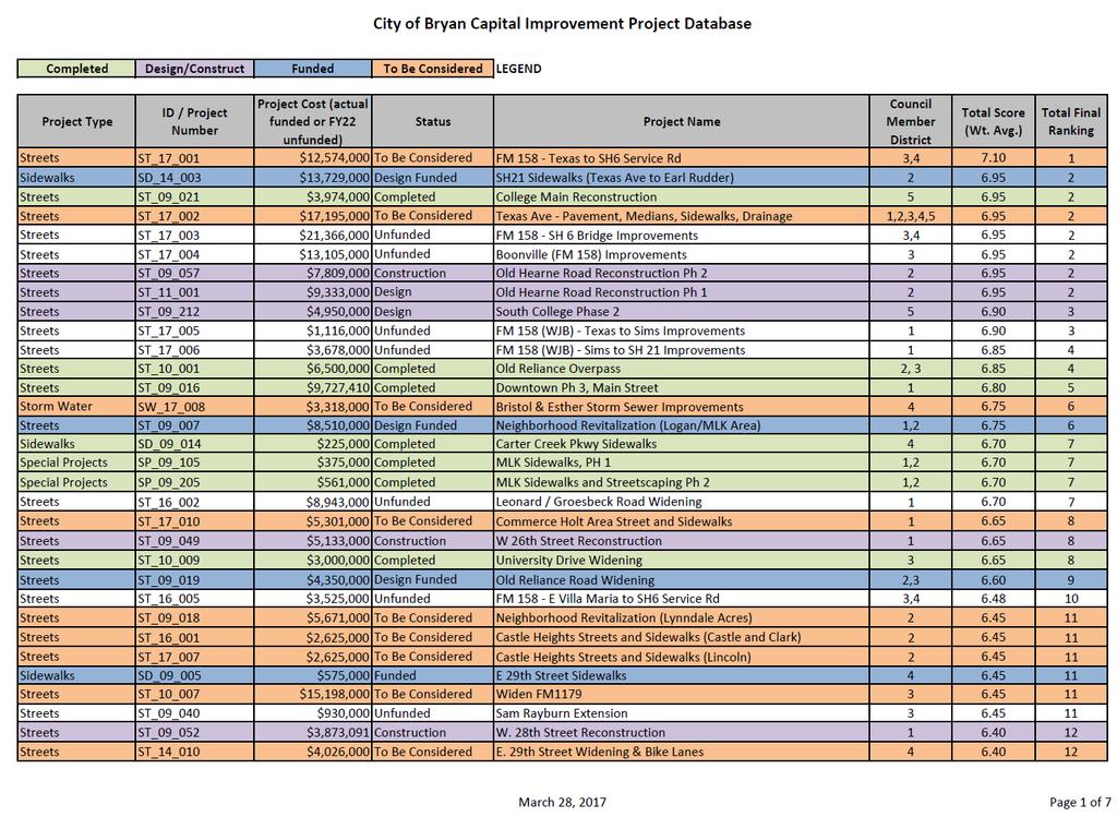
48 Project Database 220 Projects Rankings range from 1 to 64 Total points Total Costs - $894,839,281 Color Code of Spreadsheet Green Project Completed Purple Under design/construction Blue Funded in Previous 5 year plan Orange Included in proposed 5 year plan 172 Unfunded Projects - $770,051,000 48
49 Spreadsheet 49


50 Website / GIS 50

51 Typical Large CIP Schedule Year 1 Year 2 Year 3 Year 4 Design Services ~ 15 months Bid Award 2 mo. Land Acquisition ~ 12 months Utility Relocation ~ 6-8 months Construction ~ 12 months Design Services Land Acquisition Utility Relocation Construction 51
52 City Review City Review City Review Schematic Design Typical Design Phase MONTH Survey Schematic Design Preliminary Design Final Design Advertise & Award Design Services Surveying City Review Bid & Council Award 52


53 Introductory Letters Typical Land Acquisition Phase MONTH Title Reports, Contact w/ Owners, Make Offers Condemnation, (if necessary) Initial Contact Land Acquisition / Appraisals / Negotiation Condemnation (if necessary) 53
54 CIP Funding Sources Certificates of Obligation (Bond funds) Transportation Fee Drainage Fee Cemetery Funds General Fund Balance Water and Sewer for the General Fund CIP projects BTU for General Fund CIP Projects 54
55 CIP Funding Sources Certificates of Obligation (Bond Funds) Streets Buildings Sidewalks Drainage Fire Trucks 55
56 CIP Funding Sources Transportation Fee Street Reconstruction Street Maintenance Traffic Signals 56
57 CIP Funding Sources Drainage Fee Drainage Facilities Drainage Studies 57
58 CIP Funding Sources Cemetery Funds Expansion of Cemetery Facilities 58
59 CIP Funding Sources Water and Sewer Funds Water and Sewer Facilities 59

60 FY18-FY22 Planned Debt CURRENT APPROVED ADDITIONAL TOTAL FY18 $9,663,000 $2,500,000 $12,163,000 FY20 $12,446,000 $6,954,000 $19,400,000 FY22 not in approved $27,100,000 $27,100,000 Total $36,554,000 $58,663,000 60

61 Future Possible Debt for Projects FY24 - $15,100,000 FY26 - $25,100,000 FY28 - $30,100,000 61
62 Other Considerations Additional roadway projects may impact projects for Water Services and BTU Costs for projects do not include utility expenditures Projects may impact O&M (increase or decrease) Consider revenue as a result of investment 62
TIRZ 17/Redevelopment Authority Capital Improvements Plan Projects
 Gessner Widening: T-1701 What: Widen the road from a six-lane divided boulevard to an eight-lane divided boulevard street section, increase turn lanes, update traffic signal system, improve drainage by
THREE-YEAR CAPITAL IMPROVEMENT PLAN FY
 THREE-YEAR CAPITAL IMPROVEMENT PLAN FY2016 2018 Annual CIP Development Process Public Works & Engineering Divisions Prepare List of Capital Needs and Recommended Deferred Maintenance Public Works & Engineering
Municipality of Anchorage. Community Council Survey Capital Projects Needs Ranking Survey (ALPHABETICAL) Airport Heights
 Airport Heights") ANCHORAGE PARKS & RECREATION Nichols Park Design and improve neighborhood park 2008 Challenge Grant applicant. 2008 $500K State Grant for Neighborhood Parks. Tikishla Park Lighting, paved parking, hockey
ANCHORAGE PARKS & RECREATION Nichols Park Design and improve neighborhood park 2008 Challenge Grant applicant. 2008 $500K State Grant for Neighborhood Parks. Tikishla Park Lighting, paved parking, hockey
5-Year Street Reconstruction Plan ( )
") 5-Year Street Reconstruction Plan (2006-2010) City of Delano Wenck File #0564-37 Prepared for: CITY OF DELANO 234 2 nd Street West Delano, MN 55328 Prepared by: WENCK ASSOCIATES, INC. 1800 Pioneer Creek
5-Year Street Reconstruction Plan (2006-2010) City of Delano Wenck File #0564-37 Prepared for: CITY OF DELANO 234 2 nd Street West Delano, MN 55328 Prepared by: WENCK ASSOCIATES, INC. 1800 Pioneer Creek
City of Kearney Capital Improvement Update October 1, TH STREET AND 17TH AVENUE IMPROVEMENTS
 56TH STREET AND 17TH AVENUE IMPROVEMENTS FUNDING: Bonded ESTIMATED COST: $3,885,000 COMPLETION DATE: Fall 2018 SCOPE OF PROJECT: Widening of 56th Street from 6th Avenue to 19th Avenue, and widening 17th
WELCOME! 8 8:30 6: TH STREET IMPROVEMENTS. Open House. Presentation & Q&A
 WELCOME! 168 TH STREET IMPROVEMENTS 6:30 Open House 7 8 Presentation & Q&A 8 8:30 Open House WELCOME Todd Pfitzer City of Omaha Engineer Bob Stubbe City of Omaha Public Works Director Jon Meyer Project
Capital Projects in and near Odenton Town Center
 Capital Projects in and near Odenton Town Center Map ID Anne Arundel County Department of Public Works This project provides for the design, right of way acquisition, and construction of approximately
LITTLE ELM CAPTIAL IMPROVEMENT BOND STREET PRESENTATION
 LITTLE ELM 2009-2014 CAPTIAL IMPROVEMENT BOND STREET PRESENTATION Denton Frisco Little Elm Lewisville Legacy Southlake Grapevine Addison DENTON COUNTY & LEWISVILLE LAKE MATCHING FUNDS DENTON COUNTY BOND
SH 199 Corridor Master Plan. Community Meeting No. 2 May 31, 2017
 Community Meeting No. 2 May 31, 2017 Transportation Projects On or Near SH 199 SH 199 from 0.3 miles south of FM 1886 to south end of Lake Worth bridge Construct freeway mainlanes and frontage roads 10-Year
Memorandum CITY OF DALLAS. Riverfront Boulevard Design From Continental Avenue to Cadiz Street
 Memorandum DATE November 10, 2011 CITY OF DALLAS TO Trinity River Corridor Project Committee Members: Vonciel Jones Hill (Chair) Linda Koop (Vice Chair), Monica Alonzo, Scott Griggs, Angela Hunt, and Delia
Fall 2017 Construction Update
 Fall 2017 Construction Update Ward 4 Southeast Engineering Department Riverwalk Red Multi-Use Trail Bridge Rehabilitation The Riverwalk Red Multi Use Trail Bridge was awarded to Cramer and Associates,
Prince William Street Project (Grant Avenue to Wellington Road)
") Prince William Street Project (Grant Avenue to Wellington Road) 1 Goals Improve pedestrian and bike traffic safety Improve street drainage with curb & gutter Upsize water mains Enhance overall street appearance
Prince William Street Project (Grant Avenue to Wellington Road) 1 Goals Improve pedestrian and bike traffic safety Improve street drainage with curb & gutter Upsize water mains Enhance overall street appearance
Capital Projects impacting Odenton Town Center
 Capital Projects impacting Odenton Town Center 1 2 E549700 W801600/ W801602 Anne Arundel County Department of Public Works Manor View Elementary School Transmission Main - MD 32 @ Meade Phase 2 $34,399,000
JOB CREATION PROJECTS
 SPRINGDALE INFRASTRUCTURE DEVELOPMENT PLAN JOB CREATION PROJECTS The following pages provide a narrative description, preliminary street alignment and a preliminary construction cost estimate for each
INFRASTRUCTURE EXISTING INFRASTRUCTURE A. Circulation B. Signals C. Drainage D. Utilities
 7.01. EXISTING INFRASTRUCTURE A. Circulation B. Signals C. Drainage D. Utilities 7.02. PROPOSED INFRASTRUCTURE A. Overall Concept B. Circulation C. Signals D. Drainage 7.03. INFRASTRUCTURE MAP A. Key Infrastructure
Plan Policies. Introduction
 Plan Policies Introduction The purpose of the Plan Policies section is to identify the various Governing Body and Planning Commission land use related policy resolutions for use in evaluating development
PRELIMINARY PLAT DESIGN REQUIREMENTS Updated 4/8/2016
 PRELIMINARY PLAT DESIGN REQUIREMENTS Updated 4/8/2016 The following items are required for the preliminary plat. Numbers correspond with those on the example preliminary plat. RENO COUNTY SUBDIVISION REQUIREMENTS
Index to Projects by Project Name
 Index to Projects by Project Name Project # PROJECT NAME PAGE 2134 2119 PR-1109 Clayton Road (Market Street to Oakland Avenue) Sidewalk Repair 911 System Replacement and Dispatch Room Remodel ADA Barrier
Town of Yucca Valley Capital Improvement Projects Report July 24, 2014
 Town of Yucca Valley Capital Improvement Projects Report July 24, 2014 SR 62 Traffic and Pedestrian Improvements from Apache Trail to Palm Avenue (PLHD) The project includes construction of curbs, gutters,
Hunt Highway CELESTE PEMBERTON, CFM, CPM PINAL COUNTY CARLOS SANCHEZ SORIA, PE T.Y. LIN INTERNATIONAL
 Hunt Highway CELESTE PEMBERTON, CFM, CPM PINAL COUNTY CARLOS SANCHEZ SORIA, PE T.Y. LIN INTERNATIONAL Agenda Design Concept Report Phase 1 Phase 2 Phase 3 Phase 4 Phase 5 Questions Design Concept Report
AGENDA ACTION ITEMS INFORMATION ITEMS
 NOACA Bicycle and Pedestrian Advisory Council Meeting Friday, March 21 st, 2014 10:30 a.m. NOACA Office 1299 Superior Avenue Cleveland, Ohio 44114 Phone: (216) 241-2414; website: www.noaca.org AGENDA ACTION
VALLEY COUNTY MINIMUM STANDARDS FOR PRIVATE ROAD DESIGN AND CONSTRUCTION
 MINIMUM STANDARDS FOR PRIVATE ROAD DESIGN AND CONSTRUCTION Adopted November 28, 2005 TABLE OF CONTENTS DEFINITION OF TERMS...II I. DESIGN CRITERIA... 1 A. GENERAL DESIGN CRITERIA... 1 B. ROADWAY CLASSIFICATION...
Cottage Grove Road Reconstruction. City of Madison Engineering
 Public Informational Meeting Cottage Grove Road Reconstruction October 8, 2015 Presentation Outline Introduction Project Purpose & Need Proposed Design Overview Environmental Concerns Pedestrian Needs
The transportation system in a community is an
 7 TRANSPORTATION The transportation system in a community is an important factor contributing to the quality of life of the residents. Without a sound transportation system to bring both goods and patrons
EXHIBIT A 2019 FINANCING: PROJECT AUTHORIZATIONS
 EXHIBIT A 2019 FINANCING: PROJECT AUTHORIZATIONS Projects with Prior City Commission Authorization (No Changes) Downtown Canopy PW17B4CIP Prior Authorizing Ordinance: Ordinance No. 9428 Estimated Total
ADOPTED CAPITAL IMPROVEMENT PROGRAM BUDGET ARROYO PROJECTS
 ADOPTED CAPITAL IMPROVEMENT PROGRAM BUDGET ARROYO PROJECTS HAHAMONGNA FY 212-216 Capital Improvement Program Priority Description Total Estimated Costs Appropriated Through FY 211 Adopted FY 212 FY 213
CITY OF VALPARAISO STORMWATER MASTER PLAN
 CITY OF VALPARAISO STORMWATER MASTER PLAN APPROVED BY THE VALPARAISO CITY UTILITIES BOARD OCTOBER, 2016 Prepared by the City of Valparaiso Engineering Department PLAN SUMMARY Major flash flooding in August
Implementation Guide Comprehensive Plan City of Allen
 Implementation Guide 2030 Comprehensive Plan City of Allen DRAFT 2015 Implementation Guide Allen 2030 Comprehensive Plan INTRODUCTION The Comprehensive Plan serves as a guide for the growth and development
PROJECTS UNDER CONSTRUCTION
 Project Name Project Status Project Funding Project Manager PJ 2144 Clayton Rd-Treat Blvd Intersection Improvements Widen the Clayton Road/Treat Blvd intersection and upgrade the traffic signal. Construction
Index to Projects by Project Name
 Index to Projects by Project Name 2062 1701 & 1711 Concord Avenue Purchase and Demolition of Structures 85 1279 1024 UF-802 UF-803 Affordable Housing 77 Annual CIP/TIP Management Program 105 Arnold Industrial
Town of Cornelius Bond Update August, 2017
 Town of Cornelius Bond Update August, 2017 Referendum Results Roads, Intersections, & Sidewalks ($11.15 mil) Pass rate 81.38% in favor Parks and Recreation ($5.25 mil) Pass rate 72.09% in favor Town Center
Abbott Loop. Community Council Survey Capital Projects Needs Ranking Survey. Comm Council Priority Rank. Rank # ABBOTT LOOP COMMUNITY PARK
 Municipality of Anchorage Community Council Survey ABBOTT LOOP COMMUNITY PARK This state funding request would be used to implement the remaining elements of the Community Park Master Plan Vision including
BURTON STATION STRATEGIC GROWTH AREA PLAN UPDATE JANUARY 25, 2018 PUBLIC MEETING
 BURTON STATION STRATEGIC GROWTH AREA PLAN UPDATE JANUARY 25, 2018 PUBLIC MEETING 1 PRESENTATION OUTLINE History of the Burton Station SGA Plan Changes since the Plan Adoption City Infrastructure Projects
New Braunfels Growth & Development. Garry Ford, Jr., P.E., PTOE City Engineer City of New Braunfels
 New Braunfels Growth & Development Garry Ford, Jr., P.E., PTOE City Engineer City of New Braunfels Overview Growth Development Transportation Water Challenges Addressing the Growth, Development and Challenges
ARROYO PROJECTS ADOPTED CAPITAL IMPROVEMENT PROGRAM BUDGET
 A RROYO P ROJECTS ADOPTED CAPITAL IMPROVEMENT PROGRAM BUDGET FISCAL YEARS 214-218 HAHAMONGNA Priority Description 1 Hahamongna Watershed Park - Implement Master Plan 211,6 211,6 (77565) 2 Hahamongna -
4.1 Build Alternative 1 Construction Phasing
 SECTION 4 Implementation Plan This section discusses potential segmentation of the build alternatives into multiple projects for implementation of improvements to the NSH from Rabbit Creek Road to 36th
BENJAMIN BANNEKER PARK FRAMEWORK PLAN (PLAN ADOPTION)
") BENJAMIN BANNEKER PARK FRAMEWORK PLAN (PLAN ADOPTION) COUNTY BOARD MEETING DECEMBER 16, 2017 County Board Consideration: Adopt the Benjamin Banneker Park Framework Plan and Design Guidelines Framework
BENJAMIN BANNEKER PARK FRAMEWORK PLAN (PLAN ADOPTION) COUNTY BOARD MEETING DECEMBER 16, 2017 County Board Consideration: Adopt the Benjamin Banneker Park Framework Plan and Design Guidelines Framework
Welcome to the. Open House
 Welcome to the 5th Street to Kinsman Road Open House November 14 5:30 7:00 p.m. Please sign in Project Overview In December 2016, City Council adopted SW 5th Street as the preferred alignment to connect
TOWN OF JUPITER. Honorable Mayor and Members of Town Council Andrew D. Lukasik, Town Manager
 DATE: June 07, 2016 TO: THRU: TOWN OF JUPITER Honorable Mayor and Members of Town Council Andrew D. Lukasik, Town Manager FROM: Thomas V. Driscoll, P.E., Director of Engineering, Parks & Public Works SUBJECT:
July 12, Columbus City Council City Hall 90 West Broad Street Columbus, OH RE: I-70/71 Columbus Crossroads Project
 OHIO DEPARTMENT OF TRANSPORTATION DISTRICT 6 400 EAST WILLIAM STREET DELAWARE, OHIO 43015 800.372.7714 Columbus City Council City Hall 90 West Broad Street Columbus, OH 43215-9015 RE: I-70/71 Columbus
Rezoning Transportation Analysis Petition Number: General Location Identifier:
 From: Kelsie Anderson, PE Kelsie.Anderson@charlottenc.gov 704-432-5492 Staff Reviewer: Kory Hedrick, PE, PMP Khedrick@charlottenc.gov 704-432-6511 CDOT s review of this rezoning petition is intended to
State Highway 121 Southwest Parkway. Fort Worth s Transportation Success Story in Design and Cooperation
 State Highway 121 Southwest Parkway Fort Worth s Transportation Success Story in Design and Cooperation Greater Fort Worth Association of Realtors October 24, 2007 Presented by: Dan Lamers, P.E. North
Table L-1 Summary Action Strategy. Action Item Timing Status Responsible Agency
 CHAPTER 4: CIRCULATION ELEMENT ISSUE #1: MAJOR THOROUFARES AND TRANSPORTATION ROUTES A balanced transportation system for Fontana is provided that meets the mobility needs of current and future residents
4/8/2015 Item #10D Page 1
 MEETING DATE: April 8, 2015 PREPARED BY: Christy Villa, Associate Civil Engineer DEPT. DIRECTOR: Glenn Pruim DEPARTMENT: Public Works CITY MANAGER: Larry Watt SUBJECT: NORTH COAST HIGHWAY 101 STREETSCAPE
The Illinois Department of Transportation and Lake County Division of Transportation. Route 173, including the Millburn Bypass
 The Illinois Department of Transportation and Lake County Division of Transportation welcome you to this Public Hearing for U.S. Route 45 from Illinois Route 132 to Illinois Route 173, including the Millburn
SECTION 4(f) DE MINIMIS DOCUMENTATION
 DE MINIMIS DOCUMENTATION") SECTION 4(f) DE MINIMIS DOCUMENTATION Illinois Route 60/83 IL 176 to the intersection of IL 60 (Townline Road) Lake County P-91-084-07 Mundelein Park and Recreation District Project Limit SECTION 4(f)
SECTION 4(f) DE MINIMIS DOCUMENTATION Illinois Route 60/83 IL 176 to the intersection of IL 60 (Townline Road) Lake County P-91-084-07 Mundelein Park and Recreation District Project Limit SECTION 4(f)
Special Revenue Funds
 Special Revenue Funds Special Revenue Funds account for the proceeds of specific revenue sources (other than special assessments for major capital projects) that are legally restricted to expenditures
Pedestrian and Bike Bridge LOGO
 6.2.2 Pedestrian and Bike Bridge The proposed pedestrian and bike crossing re-envisions the existing bridge at Pismo Creek on Cypress Street. The bridge is currently underutilized by vehicular through
2017 General Obligation Bond
 2017 General Obligation Bond Presentation of Public and Council Projects to the Transportation & Mobility Stakeholder Committee April 13, 2017 Agenda Deferred Maintenance Project Development Process Projects
The Auburn Plan Designing the Future of Auburn February 28, 2005
 The Auburn Plan Designing the Future of Auburn February 28, 2005 Block-by-Block Bicycle Tour Aerial survey Focus Group Meetings September 7 and 8 Design Workshops October 11, 14, and 21 Revitalization
STORMWATER UTILITY FREQUENTLY ASKED QUESTIONS
 STORMWATER UTILITY FREQUENTLY ASKED QUESTIONS What is Stormwater? Stormwater is water that falls to the ground during a precipitation event. When land is undeveloped or covered with vegetative surface,
Location. Served. Category. Units Start Year. Previous Appropriations
 20142018 CAPITAL IMPROVEMENT PLAN ($ Thouss) CITY OF HOUSTON STREET & TRAFFIC CONTROL Project: TC Jester: Washington to I 10 N100002 Paving Drainage Project Description Project provides for the design
TOWN COUNCIL / PLANNING COMMISSION
 Workshop #3 TOWN COUNCIL / PLANNING COMMISSION January 20, 2011 Consultant Team In Attendance Tonight BMS Design Group Nevada City and San Francisco Michael Smiley, AICP, ASLA Partner-in-Charge Nancy L.
FY STATEWIDE TRANSPORTATION IMPROVEMENT PROGRAM New Jersey Department of Transportation Projects
 ROUTE/ Project ID No. TIP No. Burlington County Computerized Signal Control, IV D9911 D9911 This ITS project will be a traffic responsive signal system, consisting of 24 intersections--9 on CR 607, 4 on
Definitions. Average Daily Traffic Demand (ADT): The actual number or projected number of cars that pass a point in a 24-hour period.
: The actual number or projected number of cars that pass a point in a 24-hour period.") Definitions Access Management: A combination of physical techniques and transportation policies used to control the flow of traffic between roads and the surrounding lands. Alternative City Form Scenarios:
Definitions Access Management: A combination of physical techniques and transportation policies used to control the flow of traffic between roads and the surrounding lands. Alternative City Form Scenarios:
Transportation Projects Quarterly Report. Morrisville Planning Department May 22, 2018
 Transportation Projects Quarterly Report Morrisville Planning Department May 22, 2018 Transportation Improvements Most Common Ways the Town secures transportation improvements: 1. Development 2. Grant
City of Dallas Complete Streets Program. SAME Infrastructure Forum February 2, 2018
 City of Dallas Complete Streets Program SAME Infrastructure Forum February 2, 2018 Complete Streets Design Manual Adopted by City Council January 27, 2016 JANUARY 27, 2016 2 What are Complete Streets?
Street Flooding Mitigation Plan KYOVA Interstate Planning Commission. Presented to AMPO National Conference October 18, 2017
 Street Flooding Mitigation Plan KYOVA Interstate Planning Commission Presented to AMPO National Conference October 18, 2017 Saleem Salameh, Ph.D., P.E., M.ASCE Chet Parsons, AICP CTP Agenda: Background
IMPLEMENTATION STRATEGIES. In This Chapter. Goals & Strategies 182 Project List 183 Future Land Use 186 CHAPTER 11 IMPLEMENTATION STRATEGIES
 In This Chapter Goals & Strategies 182 Project List 183 Future Land Use 186 11 IMPLEMENTATION STRATEGIES NORTH AUGUSTA, SC 2017 COMPREHENSIVE PLAN 179 Individual commitment to a group effort that is what
August 13, Mayor and Council. City Manager SUBJECT: INFRASTRUCTURE CAPITAL IMPROVEMENT PLAN REPORT
 7 August 13, 2009 TO: FROM: Mayor and Council City Manager SUBJECT: INFRASTRUCTURE CAPITAL IMPROVEMENT PLAN REPORT The Director of Public Works and his fine staff prepared and submitted to you a good overview
Open House RIVER DES PERES GREENWAY: LANSDOWNE SHREWSBURY METROLINK TO FRANCIS R. SLAY PARK
 Open House 10.12.16 RIVER DES PERES GREENWAY: LANSDOWNE SHREWSBURY METROLINK TO FRANCIS R. SLAY PARK MEETING AGENDA Great Rivers Greenway and Project Partners River des Peres Greenway Overview Project
Spring 2018 Construction Update
 Spring 2018 Construction Update Ward 3 Southwest Engineering Department Locust Street Bridge over the Des Moines River The Locust Street Bridge over the Des Moines River project is being let through the
CAPITAL FUND FUTURE PROJECTS CAPITAL IMPROVEMENT PROGRAM FISCAL YEARS UNKNOWN
 FUTURE PROJECTS CAPITAL IMPROVEMENT PROGRAM FISCAL YEARS UNKNOWN FUTURE PROJECT: BRIDGE AND CULVERT REHABILITATION UNKNOWN $0 UNKNOWN $0 $0 $0 $0 $0 $0 UNKNOWN The City is responsible for the maintenance
MEETING DATE: November 12, 2013 SUBJECT: Accept Borden Road Bridge Improvement (CIP No )
") AGENDA REPORT Meeting of the San Marcos City Council MEETING DATE: November 12, 2013 SUBJECT: Accept Borden Road Bridge Improvement (CIP No. 88165) Recommendation Staff recommends the City Council adopt
AGENDA REPORT Meeting of the San Marcos City Council MEETING DATE: November 12, 2013 SUBJECT: Accept Borden Road Bridge Improvement (CIP No. 88165) Recommendation Staff recommends the City Council adopt
Section 11 Grading and Drainage Standards
 Section 11 Grading and Drainage Standards 11.1 INTRODUCTION The proper grading, conveyance, storage and release of storm water is critical to maintain the integrity of the Property. Drainage facilities,
KASPER. City of Georgetown, Texas PUD Planned Unit Development. December 30, 2015 Revised January 27, 2016
 KASPER City of Georgetown, Texas PUD Planned Unit Development December 30, 2015 Revised January 27, 2016 Applicant: Sentinel Land Company, LLC 4910 Campus Drive Newport Beach, CA Prepared by: SEC Planning
3. VISION AND GOALS. Vision Statement. Goals, Objectives and Policies
 Vision Statement Queen Creek s interconnected network of parks, trails, open spaces and recreation opportunities provide safe and diverse activities and programs that sustain its unique, small town, equestrian
Northwest Rail Corridor and US 36 BRT Development Oriented Transit Analysis 4.4 STATION AREA FINDINGS
 4.4 STATION AREA FINDINGS Each station is different, and each one requires a separate set of recommendations based on the vision for the site. This section outlines an initial TOD strategy and recommendations
Stafford County Strategic Plans
 Stafford County Strategic s Strategic Department Description Date Adopted Board of Supervisors Priorities Fiscal Responsibility Education Public Safety Infrastructure Economic Development Service Excellence
Project Overview. Fairfax County Parkway Widening Fairfax County. Get Involved. Public Information Meeting. Contact Information
 Get Involved VDOT representatives will review and evaluate information received as a result of this meeting. Please fill out the comment sheet provided in this brochure if you have any comments or questions.
Joint Meeting City Council and the Plan Commission. September 1st, 2015
 Joint Meeting City Council and the Plan Commission September 1st, 2015 1 The City Plan Commission shall recommend a City Plan for the physical development of the City Article IX Section 2 of the City of
BEST PRACTICES FOR PROJECT NOMINATIONS TA Set-Aside Program
 BEST PRACTICES FOR PROJECT NOMINATIONS 2017 TA Set-Aside Program Focus of this presentation Photos Public Support Maps & Exhibits Proposed Budget Design Details Project Evaluation & Selection Criteria
Johnson Street Bridge Public Realm Update
 Johnson Street Bridge Public Realm Update August 20, 2015 Background Johnson Street Bridge Replacement Project impacts a diverse range of stakeholders In addition to a new bridge, the project also includes
North Oakville East Parks Facilities Distribution Plan. November, 2009
 North Oakville East November, 2009 POLICY CONTEXT 1) Purpose a) The purpose of this document is to be a guide for the location, configuration, design and development of the parks system for the North Oakville
Provide and maintain sufficient public parks, recreation facilities, and open space to meet the recreational needs of County residents and visitors.
 (ROS) Goal Provide and maintain sufficient public parks, recreation facilities, and open space to meet the recreational needs of County residents and visitors. OBJECTIVE ROS.01 The County shall acquire,
2016 REVISIONS COMMENT FORM RULES AND REGULATIONS FOR CONSTRUCTION IN THE PUBLIC WAY COMMENT PERIOD: JUNE 1 TO JUNE 30, 2015
 AGENCY: 2016 REVISIONS COMMENT FORM Section Title Number Chapter 1 Introduction Comment 1.1 CDOT Mission Statement 1.2 Purpose of Rules and Regulations for Construction in the Public Way 1.3 Chicago Department
Long Branch-Wayne Local Park Renovation Project
 Montgomery Parks Long Branch-Wayne Local Park Renovation Project Community Meeting #2 September 20, 2016 Oak View Elementary School 7:00-9:00 PM Welcome / Team Introductions M-NCPPC (Montgomery Parks)
STANDARD DETAILS QUICK REFERENCE
 STANDARD DETAILS QUICK REFERENCE Note: DWGs need to be saved locally before opening file. Requires AutoCad, DWG TrueView, or Autodesk Design Review (the later two are available for free from http://usa.autodesk.com/)
Town Council Agenda Packet
 Town Council Agenda Packet The agenda and backup items follow in one continuous document. To view agenda items individually, click on the bookmark tab at the left of the screen. A list of the agenda items
Citizen Information Meeting
 Prince William County Government Citizen Information Meeting Vint Hill Road Extension May 11, 2016 Benefits: Route 28 Corridor Improvement Program Estimated significant cost savings versus bidding these
Planning Districts INTRODUCTION
 INTRODUCTION To facilitate detailed examination of development prospects for all areas of the community, Delano has been divided into 14 planning districts. The location of these planning districts is
BAGBY STREET RECONSTRUCTION PROJECT OCTOBER 2, 2015
 BAGBY STREET RECONSTRUCTION PROJECT OCTOBER 2, 2015 CLAIRE HEMPEL, PLA, AICP, LEED GA PREPARED BY Aspen Asheville Austin Chicago Denver Dubai Houston Lake Tahoe Los Angeles MIDTOWN : A MODEL OF URBAN DEVELOPMENT
Project will Replace: Utilities Curb Pavement Lighting. City of Madison
 Project will Replace: Utilities Curb Pavement Lighting Replace sanitary sewer main & laterals Winnebago: Existing 8 main, 1905 Linden: Existing 6 main, 1915, upsize to 8 main Atwood: Existing 12 main,
Southern Gateway Project and Public Green
 Southern Gateway Project and Public Green Transportation and Trinity River Project Committee May 23, 2016 Purpose of Presentation Provide the history and an overview of the Southern Gateway Project (SGP)
Project Descriptions for FY 15
 Department of Transportation and Stormwater Services Stormwater Engineering and Design Division Project Descriptions for FY 15 43 rd Street Outfall PH II Pond Regional Drainage Improvement Flooding Relief
Northeast Anthony Henday Drive Manning Freeway to Whitemud Drive Welcome to this Construction Information Session
 Manning Freeway to Whitemud Drive Welcome to this Construction Information Session Purpose To inform interested residents and businesses about the plans accommodation. Background: The Government of Alberta
include playgrounds, sports fields, community gardens and picnic areas.
 DEVELOPMENT PLAN OPEN SPACE SYSTEM OPEN SPACE SYSTEM The neighborhood provides for a range of open space types. The Village Square is an important open space in the neighborhood. It serves as a gathering
MPRD s Keith Mione (Community) Park Midlothian Road Entrance Traffic Signals
 Park Midlothian Road Entrance Traffic Signals") MPRD s Keith Mione (Community) Park Midlothian Road Entrance Traffic Signals Purpose: The Midlothian Road entrance to Mundelein Park & Recreation District s (MPRD s) Keith Mione (Community) Park would
MPRD s Keith Mione (Community) Park Midlothian Road Entrance Traffic Signals Purpose: The Midlothian Road entrance to Mundelein Park & Recreation District s (MPRD s) Keith Mione (Community) Park would
CAMPUS PLANNING COMMITTEE STAFF REPORT SAMARITAN SPORTS MEDICINE INSTITUTE AT OSU 10/21/2013
 Office of Capital Planning and Development; 130 Oak Creek Building; Corvallis, Oregon 97331-2001 CPC STAFF REPORT: SAMARITAN SPORTS MEDICINE INSTITUTE AT OSU CAMPUS PLANNING COMMITTEE STAFF REPORT SAMARITAN
Waukee. City of. The Key to Good Living
 Waukee City of The Key to Good Living City of Waukee FY15 - FY20 CIP Project Summary FY2015 FY2018 Parks Windfield Park Improvements Parks Centennial Park Amphitheater Parks Grant Park Improvements Parks
Public Meeting May 20, 2014
 Public Meeting May 20, 2014 Overview Study Purpose Study Area Overview Strategies Potential Opportunities Implementation and Discussion Skeo Solutions Raleigh Walkable Watershed Pilot 2 Purpose Develop
I-4 Beyond the Ultimate. Florida Transportation Builders Association February 9, 2018
 I-4 Beyond the Ultimate Florida Transportation Builders Association February 9, 2018 FDOT: Improving Mobility & Safety in Central Florida FDOT is Designing and building a better I-4 through Central Florida
A G E N D A Council Update Training Room September 26, :45 p.m.
 CITY OF THORNTON CITY MANAGER S OFFICE A G E N D A Council Update Training Room September 26, 2017 5:45 p.m. A. Boards and Committees Reports (Estimated 20 Minutes) 1. Rangeview Library District Meeting
Chain Bridge Road Sidewalk Improvements Citizen Council Work Session
 Chain Bridge Road Sidewalk Improvements Citizen Council Work Session May 10, 2016 Project Location 2 Project Objectives Provide a continuous pedestrian facility (sidewalk) connection from Downtown City
Date: April 10, 2017 City Council Work Session April 24, 2017: Status Report on the Comprehensive Plan Update and Transportation Master Plan
 AGENDA REPORT To: From: By: Honorable Mayor and City Council Members Warren Hutmacher, City Manager Sharon Ebert, Director Community Development Date: April 10, 2017 Agenda: City Council Work Session April
2018 Primary Road Capital Improvement Plan (CIP) Projects Preservation / Structural Improvement, Non-motorized and Engineering Design Projects
 Projects Preservation / Structural Improvement, Non-motorized and Engineering Design Projects") 2018 Primary Road Capital Improvement Plan (CIP) Projects Preservation / Structural Improvement, Non-motorized and Engineering Design Projects Preservation / Structural Improvement Projects in 2018 Ravine
2018 Primary Road Capital Improvement Plan (CIP) Projects Preservation / Structural Improvement, Non-motorized and Engineering Design Projects Preservation / Structural Improvement Projects in 2018 Ravine
CHAPTER 7: Transportation, Mobility and Circulation
 AGLE AREA COMMUNITY Plan CHAPTER 7 CHAPTER 7: Transportation, Mobility and Circulation Transportation, Mobility and Circulation The purpose of the Transportation, Mobility and Circulation Chapter is to
9 th Street Sub Area Plan
 9 th Street Sub Area Plan In the 1990 s, when the Township prepared the last Master Plan, the 9 th Street corridor was studied as part of a larger 9 th Street Focus Area that included the West Main Street
STANDARD SPECIFICATIONS Book 2 ENGINEERING DRAWINGS INCLUDES ADDENDUMS
 STANDARD SPECIFICATIONS Book 2 ENGINEERING DRAWINGS INCLUDES ADDENDUMS July 23, 2018 Page 1 of 7 STANDARD LEGEND SYMBOLS (September, 1973)... AS-101A STANDARD LEGEND SYMBOLS (September, 1973)... AS-101B
Applicant Name Phone / Fax / Address City State Zip Code . Property Owner Phone / Fax / Address City State Zip Code
 Master Development Plan Application Community Development Department City of Redmond 411 SW 9 th Street Redmond, Oregon 97756 541-923-7721 541-548-0706 FAX Master Development Plan Fee $38,862.52 File Number