3. Project Description and Attached Aerial Showing Proposed Improvement Location:
|
|
|
- Godfrey Simmons
- 5 years ago
- Views:
Transcription


1
2 RSTP Project Profile Candidate Project # 1. Project Sponsor(s): City of Roanoke, Roanoke County, and Botetourt County 2. Proposed Implementing Agencies: City of Roanoke, Roanoke County, and Botetourt County 3. Project Description and Attached Aerial Showing Proposed Improvement Location: The Tinker Creek Greenway Connectivity Study is a multijurisdictional effort to connect the established greenway segments in Roanoke City and Roanoke County/Botetourt County and to expand the scope of the greenway east into Botetourt County. The attached map shows the existing and proposed portions of the Tinker Creek Greenway. 4. Detailed Scope of Work, proposed Schedule and Relation to Other Projects or Project Phases, Project Status, and Other Funding Sources: (attach document if extra space is needed please refer to overall application limit noted above) The Tinker Creek Greenway alignment is designated as a Priority Two Greenway in the 2007 Update to the Roanoke Valley Conceptual Greenway Plan. The Tinker Creek Greenway Conceptual Master Plan completed in 2000 by the Roanoke Valley Greenway Commission and Virginia Tech Landscape Architecture students in cooperation with the City of Roanoke, Town of Vinton and Roanoke County identified possible routes for the greenway between Fallon Park in Roanoke City and Carvins Cove Natural Reserve in Roanoke County and Botetourt County, heading north along Tinker Creek and Carvins Creek. The Connectivity Study aims to reconsider those routes and others, while also heading east along Tinker Creek into Botetourt County. Detailed Scope of Work, Relation to Other Projects or Project Phases and Project Status The study shall be divided into two parts: Part A, Preliminary Engineering from Wise Ave to Roanoke County- Roanoke City currently has 1.5 miles of the Tinker Creek Greenway constructed, from the confluence of Tinker Creek with the Roanoke River north to Wise Avenue. The remaining work in the City includes the planning and preliminary engineering necessary to determine the best route to connect the greenway north from Wise Avenue to the intersection of Plantation and Hollins Roads in Roanoke County. Preliminary engineering for location of the greenway shall include, but not be limited to stakeholder and community input, right of way analysis, field work for existing conditions, GIS and ground survey, flood-plain analysis, geotechnical analysis, existing infrastructure suitability, viewshed identification, connection nodes, cost estimating, and historic/environmental/cultural resources identification. The results of this work shall provide the City with a preliminary engineering design illustrating the specific alignment of the greenway such that construction design and right of way acquisition can follow with additional funding. Part B, Roanoke County and Botetourt County Phase I Planning Analysis The northernmost segment of the Tinker Creek Greenway is located in both Roanoke and Botetourt Counties. The natural surface greenway begins in Roanoke County on Hollins University property at the Hollins Trailhead located just north of Interstate 81 on Plantation Road. The greenway continues north for 2.5 miles into Botetourt 1
3 County terminating at the boat dock at Carvins Cove Natural Reserve. Once at Carvins Cove, greenway users can access over 40 miles of trails surrounding the Western Virginia Water Authority reservoir. Hollins University has agreed to allow a southern expansion of the natural surface greenway on Hollins property from the Hollins Trailhead under Interstate 81 to an existing bridge over Carvins Creek for a distance of about 4/10 mile. This bridge is proposed to be replaced for bicycle and pedestrian use with the Friendship Lane/Carvins Creek Bridge Replacement FY14-15 RSTP application. The new bridge will connect the greenway to the planned Plantation Road Bicycle, Pedestrian and Streetscape Improvement Project, the subject of other FY14-15 RSTP applications, which will provide pedestrian and bicycle connections from the Carvins Creek bridge to the intersection of Williamson Road (Route 11) and Plantation Road. Pedestrian signals were installed at all four legs of this intersection in the summer of The Plantation Road project will provide bicycle and pedestrian amenities for the highest concentration of employees in Roanoke County (4,000), guests at 400 hotel rooms, Walrond Park users, Hollins residents as well as Hollins University students, faculty and staff. Planning-level analyses will be needed to determine the greenway route from the existing trail to the proposed Roanoke City greenway terminus at the intersection of Plantation Road and Hollins Road where Tinker Creek and Carvins Creek split. Roanoke County and Botetourt County also desire to expand the greenway to the east along Tinker Creek into Botetourt County. Notable locations in the Tinker Creek and Carvins Creek areas of Roanoke County include Mountain View Elementary School, the Community School, the Roanoke County Fleet Service Center, Fire Station Number One, Hollins Park, Sadler Park, Brookside Park, a future park at the Village at Tinker Creek subdivision, Friendship Retirement Community, industrial businesses such as Ardagh and Valcom, commercial businesses along Williamson Road and at the intersection of Plantation Road and Hollins Road. The primary goal of the study within Botetourt County is to create a connection to Lord Botetourt High School in Daleville. From that point, the proposed Daleville Greenway will connect Lord Botetourt High School, the Daleville Town Center, and the Glebe Retirement Community to existing amenities within the Botetourt Center at Greenfield. Those amenities include the Greenfield Education and Training Center, Greenfield Elementary School, Botetourt Sports Complex, and the Greenfield Recreation Park which includes seven miles of existing improved and natural surface trails, athletic fields, and a disc golf course. This portion of the work shall include, but not be limited to; studies in the areas of GIS based topographical analysis, right of way, flood-plain analysis, historical/environmental/cultural resources, schools, parks, and centers of retail and/or economic importance. Proposed Schedule: Grant Award April 2015; Procure Professional Services May-July 2015; August September 2015 Contracting Professional Services; October 2015 Contract Award; November April 2016 Planning Phase; June 2016 Final Reports and Plans Due. Other Funding Sources: None Items 5-9 Pertain to Highway Projects: 5. Functional Classification: 6. Existing Traffic Volume and Level of Service with Improvement: 7. Existing Volume/Capacity: 8. Future Traffic Volume or Projected Ridership with Service Implementation: 2
4 9. Future Volume/Capacity and Level of Service: 10. Estimated Project Cost by Phase (Preliminary Engineering, Right-of-Way (including utilities) and Construction (including administration): (attach a detailed cost estimate and/or budget to support your application) Part A Roanoke City Preliminary Engineering & Planning: $300, Part B Roanoke and Botetourt Counties Phase I Planning Analysis: $100, * See Exhibit A for budgetary breakdowns 11. RSTP Candidate Project Rating Factors A. Regional Project Consideration (30 points): This is a joint application, serving the localities of Botetourt County, Roanoke County, and the City of Roanoke. All localities herein have a vested interest in providing safe and attractive physical access for their citizens and visitors to the unique green infrastructure and natural resources that are captured within this project. Once developed, the Tinker Creek Greenway system will be located within a ten minute walk from over 14,000 Roanoke Valley residents. This project shall impact the region on many levels to include economic development, conservation of natural resources, improved natural habitat, enhanced public health through physical active transport, and tourism. Letters of support from each jurisdiction are included. B. Support the Economic Vitality of the Metropolitan Area (10 points) Greenway trails attract visitors who facilitate job growth in tourism-related businesses like restaurants, local stores, and lodging. These impacts can be seen with new businesses locating on the Roanoke River Greenway and increased marketing of this regional amenity to potential businesses. According to the Rails to Trails Conservancy, the cumulative greenway visitor expenditure data shows that destination trail users and visitors spend more than $2 million annually in hard and soft goods (including lodging) at a destination trail. As validated by the Virginia Department of Conservation and Recreation, trail visitors typically spent $ per visitor per trip. Bicycle tourists, a growing, affluent segment of the tourist market, contribute significantly to local businesses that are well-connected to trails. For example, visitors to the Virginia Creeper Trail spend $1.59 million annually providing an estimated 27 new full time jobs. According to a study conducted by the Roanoke Valley Alleghany Regional Commission for use in the IMPLAN model, every nonlocal visitor to the Roanoke Valley Greenways represented an economic impact of approximately $102 per visit in lodging, dining, transportation, and trail usage expenditures. It is anticipated that the completion of the Tinker Creek Greenway will expand tourism and economic opportunities for neighboring businesses and for the greater Roanoke Valley. C. Increase the Safety and Security of the Transportation System (10 points) The Tinker Creek Greenway will increase the safety of those who use non-motorized modes of transportation by providing accommodations separate from motorized traffic and by increasing safety measures where the two modes occupy the same space. The new greenway segments shall be designed according to the AASHTO Guide for Development of Bicycle Facilities, 4 th Edition, as well as the ADA Accessibility Guidelines for Outdoor Developed Areas. Wherever possible, crosswalks will be planned to assist users in safely crossing streets. Two sets of pedestrian signals with crosswalks are planned for the 3
5 Plantation Road project at the Plantation Road/Lila Drive intersection and the Plantation Road/Gander Way/Friendship Lane intersection. Pedestrian signals and crosswalks have recently been installed at the Plantation Road/Williamson Road intersection. D. Increase the Accessibility and Mobility Options Available to People and/or Freight (10 points) In order to promote inclusiveness and access for all ages and abilities, this plan shall use the following design criteria: the Access Board s ADA Accessibility Guidelines for Outdoor Developed Areas, and the FHWA s Designing Sidewalks and Trails for Access, the United States Forest Service s Trail Accessibility Guidelines, and guidelines and recommendations from the National Center on Accessibility at Indiana University. The greenway will be designed for walkers, runners, bicyclists, motorized and non-motorized wheelchair users and others. E. Protect and Enhance the Environment, Promote Energy Conservation, and Improve Quality of Life (10 points) Publically owned greenway corridors provide protection and conservation measures to our region s natural resources while the trail component of these greenways provides unobtrusive human access into the forest fragments, flood plains, and the rich tapestry of the regions natural resources. The establishment of new publically held greenway corridors of land amidst forests, creeks, rivers, and streams, provides exceptional opportunities to establish direct water quality improvements, flood reduction, ecosystem and habitat preservation for future generations to enjoy. Providing new active transport systems reduces fossil-fueled emissions. Prioritizing active transport systems ensures personal mobility for all income levels such that a broader cross-section of the public can reduce their fossil-fueled vehicular trips. Working regionally to increase safe and attractive trail access will provide greater reductions of carbon dioxide emissions. For every $1.00 spent on multi-use trails, there is a $2.94 direct medical benefit as identified by the Center for Disease Control (CDC). For activities such as walking and cycling, availability of close-to-home greenway trails, sidewalks and bicycle routes is an important element needed to incorporate physical activity into everyday life. The lack of accessible facilities has been identified as a deterrent to a physically active lifestyle; thus reducing one s quality of life. Research performed by Appalachian State University on the local greenway system found that our greenways positively affect the quality of life and livability of our community. The study determined that when a greenway is built within one mile of our residents, 72.4% of citizens meet the CDC s weekly physical activity recommendations; 42.8% of citizens use greenway trails multiple times weekly; 65.6% use our greenway trails for fitness and health and 63% use greenway trails for walking. In addition, 85.3% of residents stated that if given the opportunity they would move closer to a greenway trail. F. Enhance the Integration and Connectivity of the Transportation System, Across and Between Modes, for People and/or Freight (10 points) This project will connect multiple transportation systems using both current and newly developed infrastructure, including sidewalks, trails, public roadways, Valley Metro buses, bike lanes, park and ride locations, and other forms of public transit. The current transportation system within the proposed area has 4
6 limited accommodations for bicycle and pedestrian traffic. When complete, this project would enable residents of all three localities to safely travel using non-motorized methods to areas they may not have previously explored. For example, residents in downtown Roanoke could follow the Roanoke River Greenway to the Tinker Creek Greenway to Carvins Cove or travel a short distance further to access not only local, but national resources located in Botetourt County which include U.S. Bike Route 76 and the Appalachian Trail. G. Promote Efficient System Management and Operation (10 points) The study will examine and recommend designs that provide the most efficient use of materials, require the least amount of maintenance, and minimize negative environmental impacts. Potential methods will include using both road and bridge crossings and utilizing solar powered crossing activation systems where practical to provide for efficient and environmentally friendly crossing mechanisms for at-grade crossings. Part of the analysis will determine whether we can traverse under bridge decks or whether there is a need for bridge deck modifications to support bicycle and pedestrian transport. H. Emphasize the Preservation of Existing Transportation System (10 Points) This plan will examine existing transportation systems and evaluate each for its suitability to handle increased bicycle and pedestrian usage with the goal of providing a safer and more cohesive transportation system. I. Cost/Benefit Consideration (10 points) The plan will examine the most feasible elements of the greenway trail system, including life cycle cost. While much of the new greenway will be paved surfaces, some trails may be stone. Once the preferred routes have been established, the plan will categorize the different levels of trail types such as concrete, asphalt, stone, or natural. J. Projects included in previous plans that had a public input process associated with the plan (10 points) The Tinker Creek Greenway falls into several plans adopted by the local jurisdictions such as the Virginia Outdoors Plan, the 2007 Update to the Roanoke Valley Conceptual Greenway Plan, the City of Roanoke s Comprehensive Plan, the Roanoke City Parks and Recreation Master Plan, the Botetourt County Trails Plan, the Roanoke County Comprehensive Plan, the Hollins Area Plan, and the Roanoke County Parks & Recreation Master Plan. 5
7 EXHIBIT A: ESTIMATED BUDGETS Part A: Roanoke City Preliminary Engineering & Planning TASK FEE ESTIMATE Meet with Stakeholders to gather information about the site, previous community involvement results, any existing conceptual design solutions, history with adjacent properties and identify any known barriers. Obtain best available aerial photography and topographic information for initial discussions (Lidar, PDC, GIS, WVWA, AEP, Rk. Gas Co, Telecom). $15,000 Perform a Right-of-way Analysis and produce a graphic base mapping plan. $5,000 Visit the site with stakeholders to conduct fieldwork and analysis of the conditions. Potential locations for bridge crossings, underpasses, trail heads and access points will be identified and evaluated by means of a muddy boots tour with stakeholders. $15,000 Perform Geotechnical analysis. $25,000 Perform Flood Plain analysis. $15,000 Produce a Site Analysis Report consisting of a narrative and map indicating site discoveries, opportunities, and challenges. $15,000 Provide alternative concepts for the study area in graphic form. This task will begin with a meeting with stakeholders to discuss the Site Analysis Report as well as other ideas generated by the city staff. Each alternative will include a site map and other illustrative sections or perspectives to communicate the design intent. The concepts will be based on previous community and city staff input and reflect the observations within the site analysis report. Costs for alternatives will be provided in magnitude form for comparison purposes. $60,000 6
8 Conduct Public Meeting #1 $5,000 Meet with Stakeholders to ratify one alternative concept as the preferred route based upon staff and public input. Accessory options including all non-linear elements (waysides, overlooks, trail connections) will be established and be prioritized. $10,000 Establish cost estimating for preferred route. $5,000 Participate in City Council Presentation #1. Produce large format graphic representations for route, options, features, illustrative sections or perspectives. $10,000 Respond to Council Comments, refine preferred concept and options, and update cost estimate. $10,000 Initiate ground survey for Boundary and Topographical Analysis to encompass approved route plus accessory options. $70,000 Assist City Real Estate with graphic representation for any necessary property acquisitions or easements. Establish probable land/easement valuations and update cost estimate. $5,000 Conduct Public Meeting #2 $5,000 Final Deliverable: Concept Plans with illustrative sections or perspectives accompanied by report of findings and cost estimate. $20,000 Identify Critical Design Path and potential deal breakers to be resolved in next phase of design. $5,000 Assist in drafting RFP language for professional design services. $5,000 TOTAL: $300,000 7
9 Part B: Roanoke and Botetourt Counties Phase I Planning Analysis TASK Review Conceptual Planning Information: Review available information provided by the Project Sponsors that may include planning documents, mapping, photo inventories, and digital files for the project area. Base Map Preparation: Compile a base map that includes land ownership information, rights of way, historical, cultural and natural resource inventory, floodplain and floodway data, and physical attributes. The base map will be VGIN or GIS database. Project Kickoff /Design Charrette Workshop: Facilitate a collaborative design charrette workshop to develop alternative greenway alignments. The purpose of the sessions will be to generate a series of greenway route alternatives. Evaluation criteria will be developed at this stage. Development of Preliminary Greenway Alternatives: Incorporate the information gathered at the project kickoff/design charrette workshop with our initial ideas and concepts to begin development of the study. Develop preliminary alignment sketches and determining appropriate types pedestrian connectivity and connectivity of existing and proposed parks and community facilities. Project team to make a comparative analysis of each alternative. Fatal Flaw (SWOT) Analysis and Alternatives Screening Workshop - $10,000: Following development of the preliminary greenway alternatives, engineering firm shall conduct a Strength, Weaknesses, Opportunities and Threats analysis of the greenway alternatives. Each alternative shall be evaluated based on the criteria developed in the design charrette workshop. The purpose of this analysis is to identify solutions that are not feasible due to excessive environmental, economic, or political impacts. The result of this analysis shall be presented to the Project Team at an Alternative Screening Workshop. The results shall be documented in a technical study submitted to the Project Team for review and approval. FEE ESTIMATE $1,500 $5,000 $3,500 $7,500 $10,000 Analysis of Shortlisted Greenway Alternatives: Upon completion of the SWOT analysis, three (3) selected alternative greenway alignments shall be evaluated in greater detail based on design and performance criteria developed by the Project Team. This will be used to evaluate the various route alternatives developed for the project. In addition, critical property owners will be identified and discussions initiated by the Project Team to determine their position concerning the greenway crossing through their property. Assistance will be provided to the Counties as necessary. The criteria shall include, but not necessarily be limited to, information related to: a) Safety b) Constructability $10,000 8
10 c) Costs d) Environmental Considerations e) Right-of-way impacts f) Maintenance of Traffic (MOT) during the construction plans g) Design/Landscaping Themes h) Potential for economic development All design elements of the project such as horizontal alignments, typical sections, bridge structures, retaining walls, earthwork limits, and right-of-way impacts shall be depicted on the conceptual plans. Finally, an analysis of any other design issues along with preliminary recommendations for their resolution will be generated. A detailed summary of the alternatives analysis, including the Consultant s conclusions and recommendations, shall be developed and documented in a technical memorandum which shall be submitted to the Project Team for review and approval. This process will result in a single route that will be recommended for final design. Perform Site Investigation/Inventory: Perform a site investigation and inventory of the shortlisted alternative routes. Investigate other opportunities to connect to nearby communities and public facilities that may be feasible with sidewalks, bike lanes, shared use paths, and trail spurs. Includes the use of a hand held GPS to collect data such as stream crossings, areas of erosion or flooding, bridge locations, road crossings, and other areas of concern. Meet with the Project Sponsors to discuss any design issues and/or recommendations. Preliminary Environmental Analysis and Documentation: Determine areas that will be included in the environmental documentation required by VDOT. Develop necessary calculations and sketches for the applications to be submitted to Department of Historic Resources (DHR), Virginia Marine Resource Commission (VMRC), Department of Conservation and Recreation (DCR) and the Department of Game and Inland Fisheries (DGIF) for initial comments and concerns. $10,000 $7,500 Meet with Community Stakeholders/Special Interest Groups: Two representatives attend meetings, at the Project Sponsor s discretion, with representatives of the special interest groups (i.e., businesses, organizations, schools, etc.) including those that are actively involved and have been instrumental in developing the current recreation system network. Hold Public Meetings: Prepare and attend two public meetings associated with this project to review the preferred greenway alignment. Our services are intended to be supported by the County s forces and resources. Consolidate Stakeholder and Public Comments: Gather, consolidate, and summarize the public comments received. We will give the public an opportunity to submit the comment form electronically or via mail, before performing this task. Meet with Project Staff Representatives to Stakeholder and Public Input: Meet with the project staff to review the Citizen s Input and discuss the potential updates/revisions to be included in the Final Study. $2,000 $10,000 $2,500 9
11 Draft Phase 1 Conceptual Planning & Alignment Study: We will incorporate recommended changes from the design workshop, SWOT analysis, stakeholder meetings, and the public input meetings to prepare the final report document with preliminary cost estimates and recommend a final greenway alignment. The final document will include mapping of the existing segments and of the proposed segments, will describe the overall thematic concepts/ focal points, identify activity nodes along the corridor. We will include typical cross sections and photographs, where appropriate, and will include a recommended phasing schedule for implementing the study and opinions of probable construction costs associated with each phase. The final report is subject to review and approval by the Botetourt and Roanoke County Board of Supervisors. $15,000 Submission of Draft Phase 1 Conceptual Planning & Alignment Study: Compile and submit the final study to the Project Sponsors for review. Comments received from project sponsors will be incorporated into final document for public hearings and Board of Supervisors. $1,500 Assist with Presentations Project Sponsors Elected Officials: Attend two board meetings and present the final alignment study. We will prepare large displays if desirable and will discuss the process and recommendations of the master plan revision. Finalize Phase 1 Conceptual Planning & Alignment Study: The final report will be revised and finalized based upon comments received by the Board of Supervisors and public hearings. $4,000 $10,000 TOTAL: $100,000 10
12
13
14
15

16
17
18 AT A REGULAR MEETING OF THE BOARD OF SUPERVISORS OF ROANOKE COUNTY HELD AT THE ROANOKE COUNTY ADMINISTRATION CENTER ON TUESDAY, SEPTEMBER 23, 2014 RESOLUTION g REQUESTING THE ROANOKE VALLEY AREA METROPOLITAN PLANNING ORGANIZATION (RVAMPO) FUND A REGIONAL SURFACE TRANSPORTATION PROGRAM (RSTP) PROJECT FOR EXPANSION AND COMPLETION OF THE TINKER CREEK GREENWAY IN ROANOKE COUNTY, VIRGINIA WHEREAS, the City of Roanoke, Roanoke County, Botetourt County, the Town of Vinton and the Roanoke Valley Greenway Commission desire to exhibit unanimous support for all RSTP applications involving the Tinker Creek Greenway submitted to RVAMPO with the goal of expanding and completing the Tinker Creek Greenway in all four (4) jurisdictions; and WHEREAS, the Tinker Creek Greenway alignment is designated as a Priority Two Greenway in the 2007 Update to the Roanoke Valley Conceptual Greenway Plan and is planned to connect the Roanoke River Greenway to Carvins Cove Natural Reserve; and WHEREAS, the Tinker Creek Greenway Conceptual Master Plan was developed by the Roanoke Valley Greenway Commission and Virginia Tech landscape architecture students in the Landscape Architecture Department, in cooperation with the City of Roanoke, Town of Vinton and Roanoke County in Spring 2000, to identify potential routes for the Tinker Creek Greenway between Fallon Park and Carvins Cove Natural Reserve; and WHEREAS, the Tinker Creek Greenway has been completed between (1) the Roanoke River Greenway and Fallon Park in the City of Roanoke, and (2) Carvins Cove Page 1 of 3
19 Natural Reserve and the trailhead parking lot north of Interstate 81 in Botetourt County and Roanoke County; and WHEREAS, Botetourt County has developed a Comprehensive Trail Plan to direct the expansion and enhancement of its trail inventory to include establishing trail connections to the Tinker Creek Greenway for the benefit of residents in southern Botetourt County, eastern Roanoke County and other trail users; and WHEREAS, the focus of the RSTP applications is to expand and complete the Tinker Creek Greenway between Fallon Park in the City of Roanoke and the trailhead parking lot north of Interstate 81 in Roanoke County as well as into Botetourt County. NOW, THEREFORE, BE IT RESOLVED, that the Board of Supervisors requests the RVAMPO fund projects for the expansion and completion of the multijurisdictional Tinker Creek Greenway in the localities of the City of Roanoke, Roanoke County, Botetourt County and the Town of Vinton. On motion of Supervisor McNamara to adopt the resolution, and carried by the following recorded vote: AYES: Supervisors Moore, Bedrosian, Church, Peters, McNamara NAYS: None Deborah C. Jacks Deputy Clerk to the Page 2 of 3
20 cc: Megan Cronise, Principal Planner Roanoke Valley Area Metropolitan Planning Organization Stephanie M. Moon, MMC, Roanoke City Clerk Susan Johnson, Town of Vinton Clerk Susan Fain, Deputy Clerk, Botetourt County Page 3 of 3

21 September 24, KESSLER MILL ROAD SALEM, VA (FAX) Roanoke Valley Area Metropolitan Planning Organization and Transportation Technical Committee P.O. Box 2569 Roanoke, VA Dear Members of the MPO and TTC: The Roanoke Valley Greenway Commission reviewed RSTP applications at its August 27 meeting and would like to express its support for the regional application to extend Tinker Creek Greenway through Roanoke City and Vinton and on to Roanoke and Botetourt Counties. In the 2007 Greenway Plan, Roanoke River is the number one priority, and the number two priorities are the greenways that connect to it. Tinker Creek Greenway is the top one of those priorities, as it would extend all the way from Roanoke River to Carvins Cove and Botetourt County. The first section of Tinker Creek Greenway from the river to Wise Avenue opened in Now that the bridge to Roanoke River Greenway is built, this route is receiving increasing use. Extension northward is the next priority. The City moving forward to build the next piece from Wise Avenue to Orange Avenue, where road plans show a separated grade crossing. Beyond that, additional work is needed to identify the preferred alignment and secure righst-ofway. The Greenway Commission worked with the four localities in 2000 to develop a master plan for Tinker, which identified the major resources and some potential alignments. That plan is now out of date and did not include engineering considerations. There is continuing interest in this route, particularly from RCIT, other businesses, Hollins University and now Botetourt County. Additional analysis of location options is needed, as well as development of cost estimates. This study will lead to a preferred alignment and allow the localities to move toward construction. We appreciate the support of the MPO in funding Roanoke River Greenway and look forward to its completion. Thank you for your consideration of this next important greenway. Sincerely, Bob Blankenship, Chairman Roanoke Valley Greenway Commission


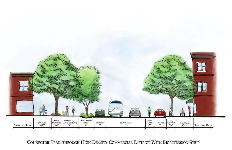
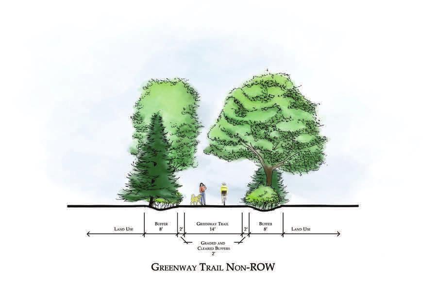

22 Possible Typical Sec ons Exhibit
23 Tinker Creek Greenway Trail Connectivity Study Greenfield Parks and Athletic Fields Greenfield Elementary School Troutville Town Park Lord Botetourt High School Botetourt County Carvins Cove Natural Reserve Cloverdale Elementary School fields Read Mountain Middle School Roanoke County Legend Plantation Road Sidewalks Tinker Creek Greenway - Proposed Carvins Cove Trails Daleville Greenway - Proposed Other Proposed Greenways Tinker Creek Greenway - Current Appalachain Trail City of Roanoke Greenfield Trails Roanoke County Shared Use Paths U.S. Bicycle Route76 Hollins University connection Roanoke City Limits Local Parks Daleville Town Center Carvin's Cove Natural Reserve Blue Ridge Parkway Boundary National Geographic, Esri, DeLorme, HERE, UNEP-WCMC, USGS, NASA, ESA, METI, NRCAN, GEBCO, NOAA, increment P Corp.
The Long Road from Planning to Breaking Ground:
 The Long Road from Planning to Breaking Ground: A Collaboration Between Roanoke County and VDOT Megan G. Cronise, AICP VDOT Coordinating Transportation and Land Use Planning Forum May 10, 2018 Where is
CITY OF CHARLOTTESVILLE, VIRGINIA CITY COUNCIL AGENDA
 CITY OF CHARLOTTESVILLE, VIRGINIA CITY COUNCIL AGENDA Agenda Date: December 16, 2013 Action Required: Adoption of Resolution Presenter: Staff Contacts: Title: James E. Tolbert, AICP, Director of NDS James
Finish Roanoke River Greenway from Green Hill Park to the Blue Ridge Parkway Regional Surface Transportation Program Application
 Finish Roanoke River Greenway from Green Hill Park to the Blue Ridge Parkway Regional Surface Transportation Program Application 1. Project Sponsors: City of Roanoke, City of Salem, Roanoke County, Town
The Illinois Department of Transportation and Lake County Division of Transportation. Route 173, including the Millburn Bypass
 The Illinois Department of Transportation and Lake County Division of Transportation welcome you to this Public Hearing for U.S. Route 45 from Illinois Route 132 to Illinois Route 173, including the Millburn
CHAPTER 7: Transportation, Mobility and Circulation
 AGLE AREA COMMUNITY Plan CHAPTER 7 CHAPTER 7: Transportation, Mobility and Circulation Transportation, Mobility and Circulation The purpose of the Transportation, Mobility and Circulation Chapter is to
OVERMOUNTAIN VICTORY TRAIL BURKE CALDELL CORRIDOR FEASIBLITY STUDY REQUEST FOR QUALIFICATIONS CALDWELL COUNTY PATHWAYS
 OVERMOUNTAIN VICTORY TRAIL BURKE CALDELL CORRIDOR FEASIBLITY STUDY REQUEST FOR QUALIFICATIONS CALDWELL COUNTY PATHWAYS Caldwell County Pathways along with our co-partners City of Lenoir, Town of Gamewell,
The transportation system in a community is an
 7 TRANSPORTATION The transportation system in a community is an important factor contributing to the quality of life of the residents. Without a sound transportation system to bring both goods and patrons
Ten Mile Creek Planning Area
 PLANNING AREA POLICIES TEN MILE CREEK Ten Mile Creek Planning Area Location and Context The Ten Mile Creek Planning Area ( Ten Mile Creek area ) is located south of the current Boise AOCI, generally south
Route 1 Corridor Study
 Route 1 Corridor Study Westbrook, Connecticut A Vision for the Connecticut Shoreline Public Informational Meeting July 28, 2015 Lower Connecticut River Valley Council of Governments Fitzgerald & Halliday,
PREPARED FOR: PLATTEVIEW ROAD CORRIDOR STUDY EXECUTIVE SUMMARY
 PREPARED FOR: PLATTEVIEW ROAD CORRIDOR STUDY EXECUTIVE SUMMARY SEPTEMBER 2016 Introduction The Platteview Road Corridor Study was led by the Metropolitan Area Planning Agency (MAPA) with assistance from
BROOKHILL NEIGHBORHOOD MODEL ZONING MAP AMENDMENT PREFACE TO APPLICATION
 BROOKHILL NEIGHBORHOOD MODEL ZONING MAP AMENDMENT PREFACE TO APPLICATION June 15, 2015 Revised: August 1, 2016 I. VISION Brookhill is a proposed community based upon the principles of Albemarle County
PROJECT BACKGROUND. Preliminary Design Scope and Tasks
 PROJECT BACKGROUND Preliminary Design Scope and Tasks The purpose of this Study is the development of preliminary designs for intersection improvements for Trunk Highway (TH) 36 at the intersections of
Mississippi Skyway Preliminary Engineering Report
 EXECUTIVE SUMMARY Mississippi Skyway Preliminary Engineering Report CITY OF RAMSEY, MINNESOTA DECEMBER 2014 City of RAMSEY EXECUTIVE SUMMARY Project Need and Intent The Mississippi Skyway pedestrian bridge
This Review Is Divided Into Two Phases:
 Semiahmoo Town Centre Review The purpose of this review: To review the Semiahmoo Town Centre Concept Plan, originally approved in 1993, to ensure that this centre will continue to serve the needs of South
Project Overview. Get Involved. Public Information Meeting. Contact Information
 Get Involved VDOT representatives will review and evaluate information received as a result of this meeting. Please fill out the comment sheet provided in this brochure if you have any comments or questions.
Small Area Plan. South Gateway
 Small Area Plan Adopted May 12, 2008 South Gateway Purpose. The South Gateway Small Area Plan defines the City s expectations for the future of the southern entrance to the City at Interstate 85 and Highway
Urban Development Areas Bedford County
 5 Urban Development Areas Bedford County UDA Needs Profile: All UDAs Bedford County has designated two UDAs: areas just outside the Bedford City Limits (generally to the south and east of the city) and
Local Growth Planning in North Central Green Line Communities
 2018 April 30 Page 1 of 6 EXECUTIVE SUMMARY This report outlines a high-level scope for local growth planning for north central Green Line communities. The catalyst for this review is the significant investments
Urban Development Area (UDA) Process in Virginia: History & Requirements
 Process in Virginia: History & Requirements") Urban Development Area (UDA) Process in Virginia: History & Requirements J. Kelli Nash Office of Intermodal Planning and Investment VDOT Coordinating Transportation & Land Use Forum Thursday, June 2, 2016
Urban Development Area (UDA) Process in Virginia: History & Requirements J. Kelli Nash Office of Intermodal Planning and Investment VDOT Coordinating Transportation & Land Use Forum Thursday, June 2, 2016
Planning Commission Report
 Planning Commission Report To: From: Subject: Planning Commission Meeting: January 6, 2016 Agenda Item: 8-B Planning Commission David Martin, Planning & Community Development Director Introduction to the
Request for Statement of Interest in Implementation of the Roosevelt Road Redevelopment Plan
 425 Hillside Avenue Request for Statement of Interest in Implementation of the Roosevelt Road Redevelopment Plan I. INTRODUCTION The is seeking the services of a qualified consulting firm to prepare plans
Overview of Southwestern Pennsylvania Commission s (SPC) 2040 Long Range Transportation Plan (LRTP)
 2040 Long Range Transportation Plan (LRTP)") Overview of Southwestern Pennsylvania Commission s (SPC) 2040 Long Range Transportation Plan (LRTP) Presented to Pennsylvania Agency Coordination Meeting May 27, 2015 Doug Smith & Ryan Gordon 1 Southwestern
Overview of Southwestern Pennsylvania Commission s (SPC) 2040 Long Range Transportation Plan (LRTP) Presented to Pennsylvania Agency Coordination Meeting May 27, 2015 Doug Smith & Ryan Gordon 1 Southwestern
1.0 INTRODUCTION 1.1 TH 14 WEST STUDY AREA Project Description Functional Classification Purpose of the Project
 1.0 INTRODUCTION 1.1 TH 14 WEST STUDY AREA 1.1.1 Project Description The Trunk Highway (TH) 14 West Corridor is a two-lane roadway approximately 22 miles in length. Located in Nicollet County, the corridor
Request for Qualifications. Knowledge Park Pedestrian/Cyclist Connectivity Planning and Design
 PUR872 I. Invitation Request for Qualifications Knowledge Park Pedestrian/Cyclist Connectivity Planning and Design The City of Rock Hill is requesting Statements of Qualifications from interested and qualified
ITS Concept Development Activity Descriptions
 ITS Concept Development Activity Descriptions October 2015 Procedures are subject to change without notice. Check the NJDOT website to ensure this is the current version. Table of Contents Concept Development
Date: April 10, 2017 City Council Work Session April 24, 2017: Status Report on the Comprehensive Plan Update and Transportation Master Plan
 AGENDA REPORT To: From: By: Honorable Mayor and City Council Members Warren Hutmacher, City Manager Sharon Ebert, Director Community Development Date: April 10, 2017 Agenda: City Council Work Session April
M E M O R A N D U M. DATE: July 19, Patrick D. O Keeffe, City Manager. Economic Development & Housing
 M E M O R A N D U M DATE: July 19, 2011 TO: FROM: Patrick D. O Keeffe, City Manager Economic Development & Housing SUBJECT: Resolution of the City Council of the City of Emeryville Approving the Application
City Council Special Meeting AGENDA ITEM NO. C.
 City Council Special Meeting AGENDA ITEM NO. C. DATE: 01/04/2019 TO: Honorable Mayor and City Council Members SUBJECT: Transit Villages Specific Plan project Study Session (Development Services Director
ARTICLE 6: Special and Planned Development Districts
 ARTICLE 6: Special and Planned Development Districts 6-10 Traditional Neighborhood Development (TND) District 6-10.10 Purpose and Intent The Traditional Neighborhood Development (TND) District provides
Town of Peru Comprehensive Plan Executive Summary
 Town of Peru Comprehensive Plan Executive Communities that plan grow by choice, not by chance. A plan makes growth thoughtful, understandable, and predictable. A plan shows that a community is managing
Town of Oakville Streetscape Strategy
 Town of Oakville Streetscape Strategy Endorsed by PDC on February 10, 2014 (PD-011-14) Town of Oakville Streetscape Strategy [endorsed by PDC February 10, 2014] 0 Town of Oakville Streetscape Strategy
Urban Planning and Land Use
 Urban Planning and Land Use 701 North 7 th Street, Room 423 Phone: (913) 573-5750 Kansas City, Kansas 66101 Fax: (913) 573-5796 Email: planninginfo@wycokck.org www.wycokck.org/planning To: From: City Planning
Potential Green Infrastructure Strategies May 6, 2015 Workshop
 Potential Green Infrastructure Strategies May 6, 2015 Workshop Background The City of Cortland is developing the Tioughnioga Urban Headwaters Green Infrastructure Action Plan with funding from the National
Introduction. Chapter 1. Purpose of the Comprehensive Plan Plan Organization Planning Process & Community Input 1-1
 Chapter 1 Introduction Lakewood 2025: Moving Forward Together Purpose of the Comprehensive Plan Plan Organization Planning Process & Community Input 1-1 Purpose of the Comprehensive Plan The Comprehensive
2035 General Plan Update and Belmont Village Specific Plan. Joint Study Session with the City Council and Planning Commission April 12, 2016
 2035 General Plan Update and Belmont Village Specific Plan Joint Study with the City Council and Planning Commission April 12, 2016 Agenda 1. Welcome and Introductions 2. General Plan Update Status of
Enhance the High Line Canal Projects
 Enhance the High Line Canal Projects Joint Project Proposal for Arapahoe County Open Spaces Funding Partner Sponsors: South Suburban Park and Recreation District City of Centennial City of Littleton October
Scope of Services. River Oaks Boulevard (SH 183) Corridor Master Plan
 Corridor Master Plan") Scope of Services River Oaks Boulevard (SH 183) Corridor Master Plan PROJECT AREA The project area consists of the River Oaks Boulevard (SH 183) corridor bounded by SH 199 at the northern end and the Trinity
Scope of Services River Oaks Boulevard (SH 183) Corridor Master Plan PROJECT AREA The project area consists of the River Oaks Boulevard (SH 183) corridor bounded by SH 199 at the northern end and the Trinity
Secrest Short Cut and Monroe Expressway Small Area Plan AUGUST 29, 2018
 Secrest Short Cut and Monroe Expressway Small Area Plan AUGUST 29, 2018 Background and Process Monroe Expressway will be open by the end of 2018 Union County and Indian Trail identified a need to revisit
RESOLUTION NO. R Refining the route, profile and stations for the Downtown Redmond Link Extension
 RESOLUTION NO. R2018-32 Refining the route, profile and stations for the Downtown Redmond Link Extension MEETING: DATE: TYPE OF ACTION: STAFF CONTACT: Capital Committee Board PROPOSED ACTION 09/13/2018
DAVIDSON MOBILITY PLAN REQUEST FOR PROPOSALS. Town of Davidson, NC June 12th, 2017
 I. GENERAL BACKGROUND DAVIDSON MOBILITY PLAN REQUEST FOR PROPOSALS Town of Davidson, NC June 12th, 2017 The Town of Davidson is a community of approximately 13,000 residents and home to Davidson College
1.0 Introduction. Purpose and Basis for Updating the TMP. Introduction 1
 1.0 Introduction The Town of Castle Rock is situated between the metropolitan areas of Denver and Colorado Springs, amidst a unique terrain of rolling hills, mesas, ravines, and waterways. Like many Front
I. DESCRIPTION OF PROPOSED ACTION... 1 A. General Description... 1 B. Historical Resume and Project Status... 2 C. Cost Estimates...
 PROJECT COMMITMENTS SUMMARY... S-1 1. Type of Action... S-1 2. Description of Action... S-1 3. Summary of Purpose and Need... S-1 4. Alternatives Considered... S-2 5. NCDOT Alternatives Carried Forward...
PROJECT STATEMENT LOCATION/DESIGN PUBLIC HEARING. 19 th AVENUE NORTH EXTENSION PROJECT FROM SPRINGDALE DRIVE TO NORTH 2 ND STREET/U.S.
 PROJECT STATEMENT LOCATION/DESIGN PUBLIC HEARING 19 th AVENUE NORTH EXTENSION PROJECT FROM SPRINGDALE DRIVE TO NORTH 2 ND STREET/U.S. 67 HEARING LOCATION: ERICKSEN COMMUNITY CENTER 1401 11 TH AVENUE NORTH
495/MetroWest Development Compact Plan Citizen Planner Training Collaborative Conference. March 17, 2012
 495/MetroWest Development Compact Plan Citizen Planner Training Collaborative Conference March 17, 2012 Project Process Local and Regional Priority Areas Growth Scenarios Transportation Investment Categories
AGENDA ITEM: IOWA. west] that were not FISCAL IMPACT. the City of Clive. STAFF REVIEW. Resolution II. Amendment PREPARED BY: REVIEWED BY:
![AGENDA ITEM: IOWA. west] that were not FISCAL IMPACT. the City of Clive. STAFF REVIEW. Resolution II. Amendment PREPARED BY: REVIEWED BY:](/thumbs/93/112428810.jpg "AGENDA ITEM: IOWA. west] that were not FISCAL IMPACT. the City of Clive. STAFF REVIEW. Resolution II. Amendment PREPARED BY: REVIEWED BY:") AGENDA ITEM: CITY OF WAUKEE, IOWA CITY COUNCIL MEETING COMMUNICATION MEETING DATE: March 7, 2016 AGENDA ITEM: Consideration of approval of a resolution approving Engineering Services Amendment No. 1 with
AGENDA ITEM: CITY OF WAUKEE, IOWA CITY COUNCIL MEETING COMMUNICATION MEETING DATE: March 7, 2016 AGENDA ITEM: Consideration of approval of a resolution approving Engineering Services Amendment No. 1 with
Rapid Transit Implementation Working Group September 14, 2017
 Rapid Transit Implementation Working Group September 14, 2017 BACKGROUND Council approved the Rapid Transit Master Plan and Updated Business Case on July 25, 2017. Approval of the RTMP confirmed the BRT
Proposed Comprehensive Plan Strategies DRAFT for discussion June 28, 2017
 Proposed Comprehensive Plan Strategies DRAFT for discussion June 28, 2017 Land Use Rural Areas Refine the Farm and Forest area (FF) Update FF boundaries to account for existing lots less than five acres
PREVIOUS PUBLIC PARTICIPATION BRIEF October 2014
 Comprehensive Planning During the development of the county comprehensive plan, Cultivating Community: A Plan for Union County s Future from 2007 through 2009, and three concurrent multi municipal plans
Gold Line Bus Rapid Transit Transit Oriented Development (BRTOD) Helmo Station Area Plan
 Helmo Station Area Plan") Appendix F Gold Line Bus Rapid Transit Transit Oriented Development (BRTOD) Helmo Station Area Plan Introduction and Purpose of the Plan The Gold Line Bus Rapid Transit facility is an eleven-mile dedicated
Appendix F Gold Line Bus Rapid Transit Transit Oriented Development (BRTOD) Helmo Station Area Plan Introduction and Purpose of the Plan The Gold Line Bus Rapid Transit facility is an eleven-mile dedicated
ARLINGTON COUNTY, VIRGINIA. County Board Agenda Item Meeting of June 16, 2018
 ARLINGTON COUNTY, VIRGINIA County Board Agenda Item Meeting of June 16, 2018 DATE: June 7, 2018 SUBJECT: Z-2604-18-1 Rezoning from R-6 and R-5 Single Family Residential Districts to S-3A Special District
Abingdon Urban Path System
 Abingdon Urban Path System Transportation Enhancement Program Application (FY 2012-2013) Submitted by: Town of Abingdon,Virginia P. O. Box 789 133 West Main Street Abingdon, VA, 24212 November 1, 2011
Pennsy Greenway Trail
 Town of Schererville Pennsy Greenway Trail DES. #s: 0401062, 1173595 & 1382661 Construction of Pennsy Greenway Trail beginning at Wilhelm Street and continuing northwest along the former Penn Central railroad
Public input has been an important part of the plan development process.
 Lakewood s Comprehensive Plan recognizes that transportation helps shape the community, and that the way the community provides for the safe and efficient movement of people affects the character of the
S C O P E O F W O R K A P R I L
 white flint 2 sector plan S C O P E O F W O R K A P R I L 2 0 1 2 MONTGOMERY COUNTY PLANNING DEPARTMENT M-NCPPC MontgomeryPlanning.org 1 white flint 2 sector plan Scope of Work abstract This scope of work
Preliminary Sketch Plan for Fort Hunter Park
 Preliminary Sketch Plan for Fort Hunter Park Public Presentation November 19, 2009 Dauphin County Parks and Recreation 100 Fort Hunter Road Harrisburg, PA 17110 (717) 599-5188 www.dauphinc.org THOMAS COMITTA
December 1, 2014 (revised) Preliminary Report -- Thomas Jefferson Site Evaluation
 Preliminary Report -- Thomas Jefferson Site Evaluation") December 1, 2014 (revised) TO: FROM: RE Arlington County Board Thomas Jefferson Site Evaluation Working Group by Carrie Johnson, Chair Preliminary Report -- Thomas Jefferson Site Evaluation The Thomas
December 1, 2014 (revised) TO: FROM: RE Arlington County Board Thomas Jefferson Site Evaluation Working Group by Carrie Johnson, Chair Preliminary Report -- Thomas Jefferson Site Evaluation The Thomas
Don Mills Crossing Study and Celestica Lands Development Application Community Meeting, Open House, and Breakout Discussions
 Consultation Summary Don Mills Crossing Study and Celestica Lands Development Application Community Meeting, Open House, and Breakout Discussions This report is not intended to provide a verbatim transcript
Request for Proposal
 Request for Proposal 10 th Street Corridor Master Plan Department of Planning and Zoning 500 Quartermaster Court Suite 200 Jeffersonville, IN 47130 April 18, 2017 For further information contact: Chad
Transportation Committee
 Transportation Committee Business Item No. 2013-286SW Meeting date: October 14, 2013 For the Metropolitan Council meeting of October 16, 2013 Subject: Southwest Light Rail Transit (Green Line Extension):
Mitchell Ranch South MPUD Application for Master Planned Unit Development Approval Project Narrative. Introduction
 Mitchell Ranch South MPUD Application for Master Planned Unit Development Approval Project Narrative Introduction Mitchell Ranch South is a proposed single family (detached) residential development on
SUMMARY. Support the Southeast Arkansas Regional Intermodal Facility.
 SUMMARY THE I-69 LOCATION STUDY The proposed I-69 Location Study from El Dorado to McGehee, Arkansas, represents one section (Section of Independent Utility No. 13) of the nationally designated I-69 Corridor
Yadkin River Greenway Feasibility Study Fact Sheet Village of Clemmons, Town of Lewisville, Town of Bermuda Run
 Fact Sheet Village of Clemmons, Town of Lewisville, Town of Bermuda Run Project Background The Yadkin River Greenway Feasibility Study is a joint project with the Village of Clemmons, the Town of Bermuda
SECTION 4(f) DE MINIMIS DOCUMENTATION
 DE MINIMIS DOCUMENTATION") SECTION 4(f) DE MINIMIS DOCUMENTATION Illinois Route 60/83 IL 176 to the intersection of IL 60 (Townline Road) Lake County P-91-084-07 Mundelein Park and Recreation District Project Limit SECTION 4(f)
SECTION 4(f) DE MINIMIS DOCUMENTATION Illinois Route 60/83 IL 176 to the intersection of IL 60 (Townline Road) Lake County P-91-084-07 Mundelein Park and Recreation District Project Limit SECTION 4(f)
PARTF Scoring System for Grants
 PARTF Scoring System for Grants The members of the N.C. Parks and Recreation Authority use the PARTF scoring system as one of several tools to select grant recipients. Please provide all of the information
RFP REQUEST FOR PROPOSALS CITY OF PORTSMOUTH, NH. DESIGN ENGINEERING SERVICES North Mill Pond Trail and Greenway
 RFP 61-18 REQUEST FOR PROPOSALS CITY OF PORTSMOUTH, NH DESIGN ENGINEERING SERVICES North Mill Pond Trail and Greenway Sealed Requests for Proposals, plainly marked RFP 61-18 Design Engineering Services
Honorable Mayor and Members of the City Council. Submitted by: Eric Angstadt, Director, Planning and Development
 Office of the City Manager ACTION CALENDAR January 29, 2013 To: From: Honorable Mayor and Members of the City Council Christine Daniel, City Manager Submitted by: Eric Angstadt, Director, Planning and
TENNESSEE STATE ROUTE 109 CORRIDOR MANAGEMENT AGREEMENT MEMORANDUM OF UNDERSTANDING CORRIDOR MANAGEMENT ALONG STATE ROUTE 109
 TENNESSEE STATE ROUTE 109 CORRIDOR MANAGEMENT AGREEMENT MEMORANDUM OF UNDERSTANDING CORRIDOR MANAGEMENT ALONG STATE ROUTE 109 I. Purpose The purpose of this Agreement is to provide a framework for the
CONSULTING SERVICES FOR THE WHITEBELT VISIONING EXERCISE ADDENDUM TO THE GTA WEST LAND USE STUDY WORK PROGRAM
 CONSULTING SERVICES FOR THE WHITEBELT VISIONING EXERCISE ADDENDUM TO THE GTA WEST LAND USE STUDY 1. Introduction WORK PROGRAM The Town of Caledon is a large, local municipality located in the Greater Toronto
Arkansas River Corridor
 Planning for Access Welcome to the Access Project. This project is a recreational planning effort in response to an interest by regional communities along the Arkansas River corridor. The project plan
TOWN OF BETHLEHEM MEETING SUMMARY LOCAL WATERFRONT REVITALIZATION PROGRAM UPDATE
 TOWN OF BETHLEHEM LOCAL WATERFRONT REVITALIZATION PROGRAM UPDATE MEETING SUMMARY Purpose: LWRP Update Public Workshop #3 Date and Time: October 24, 2017, 6:00 pm - 8:00 pm Location: Town Hall, 445 Delaware
1.0 Circulation Element
 5/9/18 1.0 Circulation Element 1.1 Introduction As growth and development occur in Apache County, enhancements to its circulation system will be necessary. With time, more roads will be paved and air and
Planning Districts INTRODUCTION
 INTRODUCTION To facilitate detailed examination of development prospects for all areas of the community, Delano has been divided into 14 planning districts. The location of these planning districts is
Town Center (part of the Comprehensive Plan)
") Town Center (part of the Comprehensive Plan) Mercer Island Town Center Looking North (2014) In 1994, a year-long process culminated in a set of design guidelines and code requirements for the Town Center
Town Center (part of the Comprehensive Plan) Mercer Island Town Center Looking North (2014) In 1994, a year-long process culminated in a set of design guidelines and code requirements for the Town Center
PUBLIC ENGAGEMENT & SIX THEMES OF THE PLAN
 Connecting the heart of Eagle to the soul of the river - Kathy Chandler-Henry, Commissioner Eagle County CHAPTER 1 PUBLIC ENGAGEMENT & SIX THEMES OF THE PLAN town of eagle - river corridor plan 1 PUBLIC
14 October 10, 2012 Public Hearing APPLICANT: MPB, INC
 14 October 10, 2012 Public Hearing APPLICANT: MPB, INC PROPERTY OWNER: MUNDEN & ASSOCIATES, LP STAFF PLANNER: Karen Prochilo REQUEST: Conditional Change of Zoning (AG-1 & AG-2 to Conditional O-2) ADDRESS
FDOT D4 Complete Streets
 FDOT D4 Complete Streets Context Sensitive Solutions Directs that complete street solutions will complement the context of the community. Collaborative approach to decision making, project development,
MEMO 1. INTRODUCTION PURPOSE & PROCESS REQUEST
 MEMO Date: August 22, 2017 To: Board of Commissioners From: Jason Burdette, Planning Director Re: Davidson Commons East Hotel Stakeholder Feedback 1. INTRODUCTION PURPOSE & PROCESS This memorandum summarizes
PART 1. Background to the Study. Avenue Study. The Danforth
 The Danforth 1.1/ Study Purpose & Key Municipal Goals 1.2/ The Local Advisory Committee 1.3/ The Project Team 1.4/ Study Process/Summary of Method 1.5/ Summary of Consultation 1.1 Study Purpose and Key
K. SMART ASSOCIATES LIMITED
 Planning Justification Report Zoning By-Law Amendment 185 King Street North Waterloo, Ontario April 7th, 2017 Project Reference Number 16-245 K. SMART ASSOCIATES LIMITED CONSULTING ENGINEERS AND PLANNERS
METROPOLITAN COUNCIL 390 North Robert Street, St. Paul, MN Phone (651) ; TDD (651)
 ; TDD (651)") DATE: December 20, 2011 METROPOLITAN COUNCIL 390 North Robert Street, St. Paul, MN 55101 Phone (651) 602-1000; TDD (651) 291-0904 TO: Metropolitan Parks and Open Space Commission FROM: Tori Dupre, Senior
DATE: December 20, 2011 METROPOLITAN COUNCIL 390 North Robert Street, St. Paul, MN 55101 Phone (651) 602-1000; TDD (651) 291-0904 TO: Metropolitan Parks and Open Space Commission FROM: Tori Dupre, Senior
Stafford County Strategic Plans
 Stafford County Strategic s Strategic Department Description Date Adopted Board of Supervisors Priorities Fiscal Responsibility Education Public Safety Infrastructure Economic Development Service Excellence
I-84 Hartford Project Open Planning Studio #12. April 25, 2017
 I-84 Hartford Project Open Planning Studio #12 April 25, 2017 Meeting Agenda 1. I-84 Hartford Project alternatives update 2. Multimodal station area planning 3. I-84 / I-91 Interchange Study coordination
DRAFT SCOPE OF SERVICES PEER REVIEW OF BAKER PARK. Request for Qualifications (RFQ)
") DRAFT SCOPE OF SERVICES PEER REVIEW OF BAKER PARK Request for Qualifications (RFQ) The following scope of services is presented for consideration and development of firm qualifications submittal. Some
DRAFT SCOPE OF SERVICES PEER REVIEW OF BAKER PARK Request for Qualifications (RFQ) The following scope of services is presented for consideration and development of firm qualifications submittal. Some
SCTPO Project Summary September 2014
 A1A MULTIMODAL CORRIDOR PLANNING AND ENGINEERING ANALYSIS Florida Department of Transportation SCTPO Project Summary September 2014 PRESENTATION FOOTER Meeting Agenda What We Plan To Do Project Background
3. VISION AND GOALS. Vision Statement. Goals, Objectives and Policies
 Vision Statement Queen Creek s interconnected network of parks, trails, open spaces and recreation opportunities provide safe and diverse activities and programs that sustain its unique, small town, equestrian
City of Farmington. Downtown Plan. Amendment to the 1998 Master Plan Adopted October 11, 2004
 City of Farmington Amendment to the 1998 Master Plan Adopted October 11, 2004 Introduction Planning Background 1 Scope and Components of the Plan Amendment 2 Concept Introduction 3 Plan Concepts 3 Conceptual
WOONASQUATUCKET RIVER WATERSHED COUNCIL REQUEST FOR PROPOSALS DESIGN OF GREENWAY PALETTE, SIGNAGE AND AMENITIES
 WOONASQUATUCKET RIVER WATERSHED COUNCIL REQUEST FOR PROPOSALS DESIGN OF GREENWAY PALETTE, SIGNAGE AND AMENITIES PROJECT BACKGROUND The Woonasquatucket River Watershed Council (WRWC) is a 501(c)3 organization
Ivywild On The Creek PRELIMINARY CREEK DISTRICT MASTER PLAN
 Ivywild On The Creek PRELIMINARY CREEK DISTRICT MASTER PLAN Introduction: Rejuvenating an extraordinary Creekside neighborhood THE CREEKSIDE DISTRICT The Ivywild On The Creek Neighborhood District Master
Urban Development Areas Frederick County
 18 Urban Development Areas Frederick County UDA Needs Profile: All UDAs Frederick County, Virginia's northernmost county has two UDA s, surrounded by the City of Winchester and located adjacent to the
DOMINION BOULEVARD CORRIDOR STUDY AND ECONOMIC DEVELOPMENT STRATEGIC PLAN A MODEL FOR CHESAPEAKE S FUTURE
 DOMINION BOULEVARD CORRIDOR STUDY AND ECONOMIC DEVELOPMENT STRATEGIC PLAN A MODEL FOR CHESAPEAKE S FUTURE Overview I. Draft Plan Process II. Draft Plan Overview a. Market Analysis b. Master Land Use Plan
CITY OF BEACON NOTICE TO LANDSCAPE ARCHITECTS GENERAL INFORMATION AND REQUEST FOR PROPOSALS
 CITY OF BEACON NOTICE TO LANDSCAPE ARCHITECTS GENERAL INFORMATION AND REQUEST FOR PROPOSALS The City of Beacon (the CITY) is issuing this Request for Proposals (RFP) for the selection of a landscape architect
1.0 Purpose of a Secondary Plan for the Masonville Transit Village
 Report to Planning and Environment Committee To: Chair and Members Planning & Environment Committee From: John M. Fleming Managing Director, Planning and City Planner Subject: Masonville Transit Village
COASTAL CONSERVANCY. Staff Recommendation June 5, 2008 SAN DIEGO RIVER TRIBUTARY CANYONS PROJECT. File No Project Manager: Megan Johnson
 COASTAL CONSERVANCY Staff Recommendation June 5, 2008 SAN DIEGO RIVER TRIBUTARY CANYONS PROJECT File No. 08-059 Project Manager: Megan Johnson RECOMMENDED ACTION: Authorization to disburse an amount not
Public Art Plan. We have elected to submit Public Art Plans before or concurrently with the CSP Submittal per the FDP Manual
 Public Art Plan The intent of the Horizon Uptown Public Arts Program is to create great places that engage the community and leverage the neighborhood development and economic vitality. The Horizon Uptown
New York Avenue Streetscape and Trail Project Public Meeting #1 Summary
 New York Avenue Streetscape and Trail Project Public Meeting #1 Summary I. King Jordan Student Academic Center (SAC) Gallaudet University, Washington, DC February 23, 2017 Table of Contents 1.0 Introduction...
Comprehensive Plan. Faribault, Minnesota. Hoisington Koegler Group Inc. Claybaugh Preservation Architecture Inc. Howard R. Green Company Bonz/REA
 Comprehensive Plan Faribault, Minnesota Adopted by the Faribault City Council July 8, 2003 prepared for: prepared by: Hoisington Koegler Group Inc. Claybaugh Preservation Architecture Inc. Howard R. Green
Council Agenda Report
 Agenda Item #5.4. Council Agenda Report SUBJECT: BRIDGE TO BEACH MULTI-USE PATHWAY PROJECT SIGNAGE, KIOSKS AND MAP DESIGN APPROVAL MEETING DATE: JUNE 21, 2012 RECOMMENDATION Staff recommends that the City
Boca Raton II Tri-Rail Station PD&E Study and 30% Documents Public Kick-Off Meeting. August 29, 2017 Spanish River Library
 Boca Raton II Tri-Rail Station PD&E Study and 30% Documents Public Kick-Off Meeting August 29, 2017 Spanish River Library Introductions 2 Partner Stakeholder Agencies FDOT District Four Palm Beach Metropolitan
NORTHEAST RIVER CROSSING FUNCTIONAL PLANNING STUDY
 WELCOME Northeast River Crossing Functional Planning Study Phase 2 Public Meeting 4 to 8 PM Informal drop-in format and discussion tables Meeting Purpose Introduce the Northeast River Crossing Functional
ESTABLISH AN EFFICIENT TOWN CENTER
 ESTABLISH AN EFFICIENT TOWN CENTER 4 Overview Lisbon residents are proud of the history of Newent and at the same time recognize its current importance as a centralized location for a variety of municipal