Welcome. South Seminole Heights Civic Association, Inc. Tampa Interstate Study Supplemental Environmental Impact Statement.
|
|
|
- Reynard Clark
- 5 years ago
- Views:
Transcription
1 Welcome South Seminole Heights Civic Association, Inc. October 17, 2018 Tampa Interstate Study Supplemental Environmental Impact Statement 1


2 Stephen Benson Opening FDOT District Seven 2

3 3

4 Our solutions are more than just interstates. Interstate Modernization Transit Bike/Ped Facilities Active/Ongoing Studies Complete Streets Transportation Innovation Freight Mobility 4
5 A New Approach to Transportation Studies: How can we work together and think differently about transportation solutions? 5

6 A New Approach Tampa Interstate Study SEIS (Westshore to Downtown) 6
 I-275 North Project Development & Environment")
7 A New Approach Tampa Interstate Study SEIS (Westshore to Downtown) I-275 North Project Development & Environment Study 7
8 A New Approach Tampa Interstate Study SEIS (Westshore to Downtown) I-275 North Project Development & Environment Study Regional Transit Plan Vision Plan & Catalyst Projects 8
 I-275 North Project")

9 A New Approach Tampa Interstate Study SEIS (Westshore to Downtown) I-275 North Project Development & Environment Study Regional Transit Plan Tampa Streetcar Extension Study (Alternatives A & B) 9


10 A New Approach Tampa Interstate Study SEIS (Westshore to Downtown) I-275 North Project Development & Environment Study Regional Transit Plan Tampa Streetcar Extension Study (Alternatives A & B) Heights Mobility Plan Florida Ave is a main street, It should be optimized for local transportation modes. There is too much cut-thru Traffic. These cars should be on I-275 but its backed up daily! Traffic calming, Walk/bike safety & TRANSIT! 10
 I-275 North Project Development & Environment")
 Heights Mobility Plan Multimodal Center")
11 A New Approach Tampa Interstate Study SEIS (Westshore to Downtown) I-275 North Project Development & Environment Study Regional Transit Plan Tampa Streetcar Extension Study (Alternatives A & B) Heights Mobility Plan Multimodal Center Studies 11


12 A New Approach Tampa Interstate Study SEIS (Westshore to Downtown) I-275 North Project Development & Environment Study Regional Transit Plan Tampa Streetcar Extension Study Heights Mobility Plan University Area Multimodal Feasibility Study BRT Corridor Analysis Florida Ave & Fowler Ave Builds off Heights Study & University Study Optimize service network to provide true BRT Service plan & stations on surface streets Covers Project Development & Engineering


13 FDOT Invests in Transit in 3 Ways: 1. Funding for Studies & Research 2. Formula-based Grants (Ongoing) Transit 3. Competitive Grants (Project-based) Intermodal Center Studies 13
14 Jeff Novotny SEIS UPDATE FDOT District Seven 14
15 Where Are We In The Process? SEIS Update We are here ALL documents remain in DRAFT form and open for public comment until after the Public Hearing in SEIS Began January 2017 Public Workshop October 2017 Preparation of Documents Ongoing Public Workshop December 2018 SEIS Public Hearing Summer 2019 *A Preferred Alternative will be recommended after the December 2018 Public Workshop. 15


16 Other Small Group Meetings to date Old Seminole Heights South Seminole Heights Tampa Heights Ridgewood Park North Bon Air Westshore Palms Oakford Park Draft Map Encore! SE Seminole Heights V.M. Ybor East Tampa Comm. Partnership Hist Ybor/East Ybor/Gary College Hill Civic Assoc. Jackson Heights Westshore Palms May 3 North Bon Air Jun 14 Tampa Heights Jun 28 Oakford Park Jul 9 East Tampa Comm. Partnership Jul 10 Encore! Jul 17 SE Seminole Heights Jul 17 Ridgewood Park Jul 24 Old Seminole Heights Aug 9 Corporation to Develop Comm. Aug 17 Trio at Encore! Aug 21 College Hill Civic Assoc. Aug 23 V.M. Ybor Neighborhood Assoc. 9/5 Ybor Chamber/Hist Ybor/East Ybor/Gary 9/11 Jackson Heights Neighborhood Assoc. 9/18 East Tampa Community Working Group 9/25 McFarlane Park/Armory Gardens 9/26 South Seminole Heights Civic Assoc. 10/17 More Scheduled College Hill Civic Assoc. Neigh. 10/25 Historic East Ybor & Gary Neigh Assoc. 10/30 16
17 SEIS Update Tampa Interstate Study (TIS) Supplemental Environmental Impact Statement (SEIS) Purpose & Need: Improve regional connectivity Provide multimodal corridor Meet future travel demand Relieve congestion Improve safety Improve accessibility 17
18 Safety 18

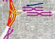
19 What is FDOT still considering for the Downtown Interchange? No Further Action Original TIS Preferred Alternative A B SEIS Update Tolled Express Lanes or Non-Tolled Express Lanes C D Four Design Options 19

20 SEIS Update How will we ultimately make a decision? Follow the Process Environment Engineering and Traffic Constructability Balance the Issues Public Comment *No single factor outweighs all others Balance the Issues 20
21 Tampa Interstate Study SEIS A project s environmental impacts, engineering considerations, and public comments aid in the decision-making process. This graphic lists the various documents that FDOT will prepare as a part of this process. Draft documents will be available at the December 10 & 13, 2018 Public Workshop. Sociocultural Effects Natural and Physical Effects Engineering Considerations Public Outreach SCE Tech Memo (includes Environmental Justice and Economic Considerations) Cultural Resources Assessment Survey/Section 106 Case Study Conceptual Relocation Plan Air Quality Tech Memo Natural Resources Evaluation Noise Tech Memo Contamination Screening Preliminary Engineering Traffic Tech Memo Pond Siting Public and Agency Coordination Plan Comments and Coordination Tech Memo Small Group Meeting Public Workshop/ Hearing 21
22 SEIS Update Sociocultural Effects (SCE) Social Economic Land Use Mobility Aesthetics Relocation Demographics Community Cohesion Safety Community Goals/Quality of Life Special Community Designations Business & Employment Tax Base Traffic Patterns Business Access Special Needs Patrons Land Use- Urban Form Plan Consistency Growth Trends & Issues Focal Points Mobility Choices Accessibility Connectivity Traffic Circulation Public Parking Noise/Vibration Viewshed Compatibility Residential Non-Residential Public Facilities 22


23 Area of Influence Draft Map South Seminole Heights Civic Association ½ mile area of influence Draft Map 23


24 South Seminole Heights Civic Association Demographic Information from GIS Tool Percent Minority Population Draft Map Draft Map 24


25 South Seminole Heights Civic Association Demographic Information from GIS Tool Population Below Poverty Draft Map Draft Map 25


26 Community Features South Seminole Heights Civic Association Draft Map 26
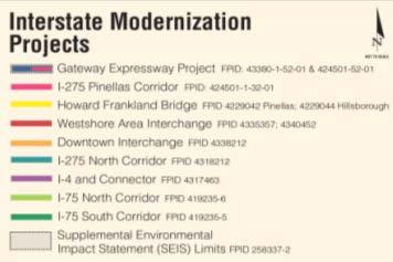
27 Downtown Tampa Interchange SEIS Alternatives 27
28 No Further Action Where no additional construction was previously approved No impacts to the physical environment Does not require property acquisition Does not relieve congestion Potential decrease in air quality Potential increase in traffic noise, or no remedy for noise Does not provide multimodal corridor Does not improve regional connectivity Does not meet future travel demand Does not provide safety improvements Does not improve accessibility 28


29 Various portions have already been approved and constructed 1996 Long Term Preferred as updated 29
30 Build Alternatives Tolled or Non-tolled Express Lanes 4 Design Options *Boulevard and Beltway are being investigated as a part of the Hillsborough County MPO s Long Range Transportation Plan (LRTP) process. 30
31 Reconstructed Interchange with Express Lane Ramps to the North General Purpose Lanes New Construction Express Lanes Collector / Distributor Lanes Non-Interstate Roadwork ROW Footprint ( new parcels) 31
32 Reconstructed Interchange without Express Lane Ramps to the North General Purpose Lanes New Construction Express Lanes Collector / Distributor Lanes Non-Interstate Roadwork ROW Footprint ( new parcels) 32
33 Existing Interchange with Elevated Express Lanes South Option General Purpose Lanes New Construction Express Lanes Collector / Distributor Lanes Non-Interstate Roadwork ROW Footprint (30-50 new parcels) 33
")
34 Existing Interchange with Elevated Express Lanes North Option General Purpose Lanes New Construction Express Lanes Collector / Distributor Lanes Non-Interstate Roadwork ROW Footprint (60-80 new parcels) 34

35 No Further Action Evaluating the Tolled Express Lanes or Non-Tolled Express Lanes Impacts Original TIS Preferred Alternative A B C D Four Design Options Each alternative & design option has differences, trade-offs 35
36 Steve Gordillo I-275 NORTH PD&E STUDY UPDATE FDOT District Seven 36


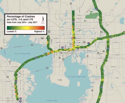
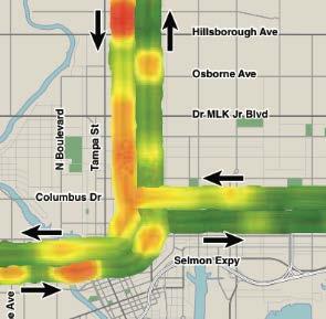
37 North Corridor What Problems Are We Trying To Solve? Safety Traffic Operations Congestion Choice

38 North Corridor Tampa Bay Next Interstate Modernization Projects (Hillsborough & Pinellas Counties)


")
39 North Corridor I-275 North Corridor Under PD&E Study Project limits are from north of Dr. Martin Luther King, Jr. Boulevard (SR 574) Osborne Avenue to north of Bearss Avenue (SR 678/CR 582) Distance of approximately 7.64 miles 39
40 North Corridor Project Purpose and Need The purpose of the project is to provide one additional general purpose lane in each direction along I-275 from north of Dr. Martin Luther King Jr. Boulevard (SR 574) to north of Bearss Avenue (SR 678/CR 582) to: Enhance Corridor Capacity Enhance Overall Safety Enhance the Corridor Operating Conditions Support Future Transit Accommodate Future Growth Statewide and regional transportation plans and studies identify the need for interstate improvements.
41 North Corridor Tampa Bay Talked. We Listened. What the community wants: What we re doing about it: Hub System for Transit Intermodal Center Studies Multimodal Options Funding Next Phase of Project Development for RTFP Technology Solutions Neighborhood Preservation Prioritize Safety Formed Tech Team; Working with City and County to Maximize Existing Pavement Advanced the Heights Study; Created New Downtown Interchange Concepts Education/Explain Transportation More Online & Recorded Meetings Complete Streets; Working on Improved Road Geometry; Tech Solutions to Enhance Safety Developed Citizens Transportation Academy Utilizing Webinars and Posting Recordings Online


42 North Corridor NO EXPRESS LANES FDOT is no longer considering the addition of express lanes on the section of I-275 north of the I-4 interchange! Trench with One Express Lane in Each Direction Reversible Express Lane One Express Lane in Each Direction with Pylon Option One Express Lane in Each Direction with Bus on Shoulder One Elevated Express Lane in Each Direction


43 Recommended Proposed Typical Section North Corridor


 Captain William Parker Jackson")
 Harding s Court (E) Seminole Heights Elementary School (E)")
 Seminole Heights Baptist Church (E) Sulphur Springs Park Resource")

44 North Corridor Section 106 National Historic Preservation Act Section 106 requires Federal agencies to take into account the effects of their undertakings on historic properties. There are eight total historic resources either National Register Listed (L), or considered National Register Eligible (E), within the project s Area of Potential Effects, based on the historic resources survey. Seminole Heights Historic District (L) Captain William Parker Jackson House (L) T&GC Railroad/CSX Railroad (E) Sulphur Springs Park Resource Group (E) Harding s Court (E) Seminole Heights Elementary School (E) City Fire Dept. Engine Company No. 7 (E) Seminole Heights Baptist Church (E) Sulphur Springs Park Resource Group Harding s Court Seminole Heights Historic District Capt. Wm. Parker Jackson House Seminole Heights Baptist Church T&GC Railroad/CSX Railroad Seminole Heights Elementar City Fire Dept. Engine Co. No. 7 There are no anticipated effects to any listed or eligible historic resources within the pro


45 Sound Walls* North Corridor Aesthetic Treatment Early construction to mitigate traffic and construction noise, where possible Future coordination with affected property owners and local government to take place during the next project phase * Noise Analysis Report To Be Completed 45

 Yellow text indicates underpass is within a historic district.")


46 Pedestrian Friendly Underpass Improvements North Corridor Rendering of Future Condition 6-Lane Widen Sidewalks Enhance Lighting Paint Bridge Sub-Structure Cut-back Walls for Improved Bike/Pedestrian Experience Include Public Art (in cooperation with the City of Tampa) Yellow text indicates underpass is within a historic district. Identify Landscape Opportunities Linebaugh Avenue Yukon Street Bird Street Sligh Avenue Bougainvillea Avenue Busch Boulevard Waters Avenue Broad Street Hanna Avenue Hillsborough Avenue Osborne Avenue Rendering of Future Condition 4-Lane Listed improvements are yet to be finalized for each underpass. All improvements will not be included at every underpass. 46


47 Landscape Opportunities North Corridor FDOT Right of Way along Sound Walls Adjacent to Underpasses Red Maple Crepe Myrtle Live Oak Magnolia
48 Summary Project will: Enhance Connectivity Under the Interstate Accommodate Potential Transit Opportunities Identify Landscape Opportunities Include Noise Barrier Walls where Feasible Project will NOT: North Corridor Acquire Additional Right of Way from North of Dr. Martin Luther King, Jr. Boulevard (SR 574) to North of Bearss Avenue* Acquire Right of Way in the Seminole Heights Historic District *Minor right of way acquisition may be required at the Bearss Avenue interchange for pond siting.

49 Questions? 49

50 Thank you! How can we best reach you? Our site also contains NEPA overview videos and customer perspectives; Socio-cultural Effects, and more. Please also visit TampaInterstateStudy.com 50

51 How do you access I-275 & I-4? 60


52 Removed or moved How do you access I-275 & I-4? What s changing with build options Also adding downtown access to express lanes 61
53 A New Approach Tampa Interstate Study SEIS (Westshore to Downtown) I-275 North Project Development & Environment Study Regional Transit Plan Tampa Streetcar Extension Study Heights Mobility Plan University Area Multimodal Feasibility Study BRT Corridor Analysis Florida Ave & Fowler Ave
Welcome. Tina Fischer. East Tampa Area Community Working Group September 25, Collaborative Labs, St. Petersburg College
 Welcome East Tampa Area Community Working Group September 25, 2018 Tina Fischer Collaborative Labs, St. Petersburg College Tonight s Agenda Open House Area (6:00 - ongoing) Information about related studies,
A Connected Region for Our Future. Tampa Bay Regional Planning Council
 A Connected Region for Our Future Tampa Bay Regional Planning Council TBARTA Vision A world class transportation network for the Tampa Bay region that will connect people and places, move goods and services,
PUBLIC HEARING. Thursday, December 14, 2017 FDOT Urban Office 2198 Edison Avenue Jacksonville, FL 32204
 DISTRICT TWO PUBLIC HEARING I 10 (SR 8) from I 295 to I 95 Project Development & Environment Study Duval County, Florida Financial Project Number 213326 2 22 01 Efficient Transportation Decision Making
PD&E STUDY SR 9/I-95 FROM SOUTH OF SR 870/COMMERCIAL BOULEVARD TO NORTH OF CYPRESS CREEK ROAD FM # ETDM 14222
 PD&E STUDY SR 870/COMMERCIAL BOULEVARD TO NORTH OF CYPRESS CREEK ROAD FM # 435808-1-22-02 ETDM 14222 WELCOME TO THE KICK-OFF MEETING May 24, 2016 1 1 2 3 4 5 6 PLANNING PROJECT DEVELOPMENT AND ENVIRONMENT
BeltLine Corridor Environmental Study
 BeltLine Corridor Environmental Study Joint TAC and SAC Meeting December 8, 2008 What We Will Discuss Today Outreach and Agency Coordination Scoping Results Existing Conditions Historical and Archeological
BeltLine Corridor Environmental Study
 BeltLine Corridor Environmental Study Citywide Conversation on Transit and Trails April 2, 2009 Agenda & Introductions Introductions Environmental Study Process Overview of the BeltLine Project BeltLine
Public Hearing. Charlotte County-Punta Gorda MPO - Meeting Rooms A and B March 14, open house at 4 p.m., formal presentation at 5 p.m.
 Public Hearing Charlotte County-Punta Gorda MPO - Meeting Rooms A and B March 14, 2019 open house at 4 p.m., formal presentation at 5 p.m. Welcome to the Public Hearing for the Harborview Road (CR 776)
Hillsborough County MPO Transit Study. Citizens Team Workshop Wednesday, February 28 th, 2006 Hillsborough Community College - Brandon
 Hillsborough County MPO Transit Study Citizens Team Workshop Wednesday, February 28 th, 2006 Hillsborough Community College - Brandon What is the MPO Transit Study? An effort to look at the full range
SAN MARTIN BOULEVARD OVER RIVIERA BAY PROJECT DEVELOPMENT & ENVIRONMENT (PD&E) STUDY
 STUDY") KICK-OFF PRESENTATION SAN MARTIN BOULEVARD OVER RIVIERA BAY PROJECT DEVELOPMENT & ENVIRONMENT (PD&E) STUDY PROJECT IDENTIFICATION NUMBER (PID): #001036A May 13, 2015 1 2 PROJECT LOCATION PROJECT HISTORY
KICK-OFF PRESENTATION SAN MARTIN BOULEVARD OVER RIVIERA BAY PROJECT DEVELOPMENT & ENVIRONMENT (PD&E) STUDY PROJECT IDENTIFICATION NUMBER (PID): #001036A May 13, 2015 1 2 PROJECT LOCATION PROJECT HISTORY
AASHTO SUBCOMMITTEE ON DESIGN. June 15, 2006 MARK ROBINSON, P.E. DISTRICT 5 INTERSTATE PROGRAM MANAGER FLORIDA DEPARTMENT OF TRANSPORTATION
 AASHTO SUBCOMMITTEE ON DESIGN June 15, 2006 MARK ROBINSON, P.E. DISTRICT 5 INTERSTATE PROGRAM MANAGER FLORIDA DEPARTMENT OF TRANSPORTATION CENTRAL FLORIDA INTERSTATE 4 FACTS Trucks and Others 12% Tourist
HILLSBOROUGH COUNTY Greenways and Trails Plan Update. Executive Summary. Date
 HILLSBOROUGH COUNTY Greenways and Trails Plan Update Executive Summary Date PURPOSE AND PROJECT OVERVIEW The Hillsborough County Greenways Master Plan (1995) and the City of Tampa s Greenways and Trails
SH 199 Corridor Master Plan. Community Meeting No. 2 May 31, 2017
 Community Meeting No. 2 May 31, 2017 Transportation Projects On or Near SH 199 SH 199 from 0.3 miles south of FM 1886 to south end of Lake Worth bridge Construct freeway mainlanes and frontage roads 10-Year
We d like to thank you for attending this Wekiva Parkway Section 8 Preliminary Design Update hosted by the Florida Department of Transportation.
 We d like to thank you for attending this Wekiva Parkway Section 8 Preliminary Design Update hosted by the Florida Department of Transportation. We will provide you information on the overall project and
TRANSPORTATION ELEMENT
 TRANSPORTATION ELEMENT GOAL I: To create and maintain a safe, efficient and aesthetic transportation system that encourages multi-modal transportation and promotes the mobility strategies of the Ocala
Construction Engineering & Inspection
 Construction Engineering & Inspection Serving Florida for 20 Years CEI Engineering Planning Landscape Architecture Urban Design Construction Engineering & Inspection (CEI) I N T R O D U C T I O N Over
Boca Raton II Tri-Rail Station PD&E Study and 30% Documents Public Kick-Off Meeting. August 29, 2017 Spanish River Library
 Boca Raton II Tri-Rail Station PD&E Study and 30% Documents Public Kick-Off Meeting August 29, 2017 Spanish River Library Introductions 2 Partner Stakeholder Agencies FDOT District Four Palm Beach Metropolitan
ALTERNATIVES. NCDOT made an early decision to first determine how to build the project (construction method) followed by what to build (alternatives).
 followed by what to build (alternatives).") III. ALTERNATIVES A. CONSTRUCTION METHOD ALTERNATIVES NCDOT made an early decision to first determine how to build the project (construction method) followed by what to build (alternatives). One of the
III. ALTERNATIVES A. CONSTRUCTION METHOD ALTERNATIVES NCDOT made an early decision to first determine how to build the project (construction method) followed by what to build (alternatives). One of the
Lesson 6. Corridor Planning
 Lesson 6 Corridor Planning 1 Learning Outcomes Identify land use strategies and solutions that can be incorporated into multimodal transportation corridor plans Identify land use stakeholders and describe
Transit / Housing Oriented Redevelopment
 Broward County Urban Planning and Redevelopment Department Kick-Off Meeting October 24, 2007 Transit / Housing Oriented Redevelopment 1 Future Land Use 2 Broward County Charter Voters approved in 1974.
Chapter 6: Measures of Effectiveness
 Chapter 6: Measures of Effectiveness Public Input Results Issues identified through public input and responded to by the MPO and documented revisions to plans based on citizen input Progressive and creative
ARLINGTON COUNTY, VIRGINIA. County Board Agenda Item Meeting of January 28, 2017 SUPPLEMENTAL REPORT
 ARLINGTON COUNTY, VIRGINIA County Board Agenda Item Meeting of January 28, 2017 SUPPLEMENTAL REPORT DATE: January 26, 2017 SUBJECT: The Virginia Department of Transportation s Transform I-66 Inside the
TRANSPORTATION ELEMENT GOALS, OBJECTIVES, AND POLICIES
 TRANSPORTATION ELEMENT GOALS, OBJECTIVES, AND POLICIES GOAL 2 The City shall provide a safe, convenient, effective, and energy efficient multimodal transportation system which is coordinated with the Future
ARLINGTON COUNTY, VIRGINIA. County Board Agenda Item Meeting of January 28, 2017 SUPPLEMENTAL REPORT-2
 ARLINGTON COUNTY, VIRGINIA County Board Agenda Item Meeting of January 28, 2017 SUPPLEMENTAL REPORT-2 DATE: January 27, 2017 SUBJECT: The Virginia Department of Transportation s Transform I-66 Inside the
Project Update. Hillsborough County 2045 Population and Employment Projections and Allocations. Board of County Commissioners February 13, 2018
 Hillsborough County 2045 Population and Employment Projections and Allocations Project Update Board of County Commissioners February 13, 2018 What will Hillsborough County look like in 25 years? Working
Figure 5. Previously Identified Viable Corridors
 OVERVIEW The Central Florida Expressway Authority (CFX) is evaluating the potential to expand SR 408 from its current eastern terminus along SR 50 to SR 520 in northeastern Orange County, Fl. This new
PROJECT BACKGROUND. Preliminary Design Scope and Tasks
 PROJECT BACKGROUND Preliminary Design Scope and Tasks The purpose of this Study is the development of preliminary designs for intersection improvements for Trunk Highway (TH) 36 at the intersections of
Gratigny Parkway East Extension Project Development & Environment (PD&E) Study
 Study") Gratigny Parkway East Extension Project Development & Environment (PD&E) Study Session 4: Presentation of Charrette Results December 8, 2010 MDX Work Program #: 92407 ETDM#: 11500 Project Location & Description
Gratigny Parkway East Extension Project Development & Environment (PD&E) Study Session 4: Presentation of Charrette Results December 8, 2010 MDX Work Program #: 92407 ETDM#: 11500 Project Location & Description
Atlanta BeltLine Corridor Environmental Study. Scoping Meeting August 2008
 Atlanta BeltLine Corridor Environmental Study Scoping Meeting August 2008 What Will We Be Discussing Today? Study Overview - How Did We Get Here? - What Is the Study About? - Who Is Involved? - Where Is
PLAN ELEMENTS WORKSHOP. April 5, 2016
 PLAN ELEMENTS WORKSHOP April 5, 2016 needs more housing. But there is no one-size fits-all solution. Every neighborhood has its own character. In some places, density is not only appropriate it is badly
Ashland BRT Environmental Assessment: logos of CTA, CDOT, Chicago Department of Housing and Economic Development
 Ashland BRT Environmental Assessment: logos of CTA, CDOT, Chicago Department of Housing and Economic Development Overview The Chicago Transit Authority (CTA), in partnership with the Chicago Department
Southern Gateway Project and Public Green
 Southern Gateway Project and Public Green Transportation and Trinity River Project Committee May 23, 2016 Purpose of Presentation Provide the history and an overview of the Southern Gateway Project (SGP)
PUBLIC HEARING. DRAFT Environmental Impact Statement. Matthews Memorial Baptist Church Washington, DC October 18, National Capital Region
 National Capital Region DRAFT Environmental Impact Statement PUBLIC HEARING Matthews Memorial Baptist Church Washington, DC October 18, 2007 Introduction Welcome and team introduction Hearing procedures
Northwest Rail Corridor and US 36 BRT Development Oriented Transit Analysis 4.4 STATION AREA FINDINGS
 4.4 STATION AREA FINDINGS Each station is different, and each one requires a separate set of recommendations based on the vision for the site. This section outlines an initial TOD strategy and recommendations
FDOT D4 Complete Streets
 FDOT D4 Complete Streets Context Sensitive Solutions Directs that complete street solutions will complement the context of the community. Collaborative approach to decision making, project development,
I-4 Beyond the Ultimate. Florida Transportation Builders Association February 9, 2018
 I-4 Beyond the Ultimate Florida Transportation Builders Association February 9, 2018 FDOT: Improving Mobility & Safety in Central Florida FDOT is Designing and building a better I-4 through Central Florida
Howard Frankland Bridge Regional Transit Corridor Evaluation
 Howard Frankland Bridge Regional Transit Corridor Evaluation St Pete Planning & Vision Commission October 11, 2011 FPN: 422799 1 12 04 2 Project Website www.mytbi.com Click on Future Projects, then I-275
1.0 INTRODUCTION 1.1 TH 14 WEST STUDY AREA Project Description Functional Classification Purpose of the Project
 1.0 INTRODUCTION 1.1 TH 14 WEST STUDY AREA 1.1.1 Project Description The Trunk Highway (TH) 14 West Corridor is a two-lane roadway approximately 22 miles in length. Located in Nicollet County, the corridor
I-84 Hartford Project Open Planning Studio #12. April 25, 2017
 I-84 Hartford Project Open Planning Studio #12 April 25, 2017 Meeting Agenda 1. I-84 Hartford Project alternatives update 2. Multimodal station area planning 3. I-84 / I-91 Interchange Study coordination
Denver Moves: Transit Task Force
 Insert transit picture Denver Moves: Transit Task Force Meeting #8 October 5, 2017 1. Welcome & Introductions Opening remarks and housekeeping Task Force and audience introductions Upcoming events and
Southeast Extension to RidgeGate Parkway Scoping Booklet
 Southeast Extension to RidgeGate Parkway Scoping Booklet PUBLIC SCOPING MEETING SCHEDULE Public Scoping Meeting Wednesday, November 2, 2011 6:00pm to 7:30pm City of Lone Tree Recreation Center Willow Room
COLLIER BOULEVARD (CR 951) CORRIDOR
 CORRIDOR") Project(s) Goals Improve Traffic Circulation, Capacity & Safety Focus on Safety During Design & Construction Address Public Concerns Design an Aesthetically Pleasing Project Limit Environmental Impacts
Project(s) Goals Improve Traffic Circulation, Capacity & Safety Focus on Safety During Design & Construction Address Public Concerns Design an Aesthetically Pleasing Project Limit Environmental Impacts
AGENDA ITEM 3A Red Hills Coastal Parkway
 March 26, 2007 AGENDA ITEM 3A Red Hills Coastal Parkway REQUESTED BY: CRTPA Members TYPE OF ITEM: Discussion STATEMENT OF ISSUE At the January 22, 2006 Capital Region Transportation Planning Agency (CRTPA)
Corridor Vision. 1Pursue Minnehaha-Hiawatha Community Works Project. Mission of Hennepin County Community Works Program
 1Pursue Minnehaha-Hiawatha Community Works Project Minnehaha-Hiawatha Community Works is a project within the Hennepin Community Works (HCW) program. The mission of the HCW program is to enhance how the
Capital Projects in and near Odenton Town Center
 Capital Projects in and near Odenton Town Center Map ID Anne Arundel County Department of Public Works This project provides for the design, right of way acquisition, and construction of approximately
PREPARED FOR: PLATTEVIEW ROAD CORRIDOR STUDY EXECUTIVE SUMMARY
 PREPARED FOR: PLATTEVIEW ROAD CORRIDOR STUDY EXECUTIVE SUMMARY SEPTEMBER 2016 Introduction The Platteview Road Corridor Study was led by the Metropolitan Area Planning Agency (MAPA) with assistance from
MDX SR 836/DOLPHIN EXPRESSWAY SOUTHWEST EXTENSION
 MDX SR 836/DOLPHIN EXPRESSWAY SOUTHWEST EXTENSION Project Development and Environment (PD&E) STUDY Miami-Dade County, Florida Preliminary Executive Summary Alternative Corridor Evaluation (ACE) Report
State Highway 121 Southwest Parkway. Fort Worth s Transportation Success Story in Design and Cooperation
 State Highway 121 Southwest Parkway Fort Worth s Transportation Success Story in Design and Cooperation Greater Fort Worth Association of Realtors October 24, 2007 Presented by: Dan Lamers, P.E. North
Project Overview. Fairfax County Parkway Widening Fairfax County. Get Involved. Public Information Meeting. Contact Information
 Get Involved VDOT representatives will review and evaluate information received as a result of this meeting. Please fill out the comment sheet provided in this brochure if you have any comments or questions.
Scope of Services. River Oaks Boulevard (SH 183) Corridor Master Plan
 Corridor Master Plan") Scope of Services River Oaks Boulevard (SH 183) Corridor Master Plan PROJECT AREA The project area consists of the River Oaks Boulevard (SH 183) corridor bounded by SH 199 at the northern end and the Trinity
Scope of Services River Oaks Boulevard (SH 183) Corridor Master Plan PROJECT AREA The project area consists of the River Oaks Boulevard (SH 183) corridor bounded by SH 199 at the northern end and the Trinity
Project Overview. Get Involved. Public Information Meeting. Contact Information
 Get Involved VDOT representatives will review and evaluate information received as a result of this meeting. Please fill out the comment sheet provided in this brochure if you have any comments or questions.
Onondaga County Sustainable Streets Project. Onondaga County Planning Federation June 7, Onondaga County Sustainable Streets Project 1
 Onondaga County Sustainable Streets Project Onondaga County Planning Federation June 7, 2012 Onondaga County Sustainable Streets Project 1 Sustainable Streets 1. Introduction to the SMTC 2. Sustainable
Route 1 Corridor Study
 Route 1 Corridor Study Westbrook, Connecticut A Vision for the Connecticut Shoreline Public Informational Meeting July 28, 2015 Lower Connecticut River Valley Council of Governments Fitzgerald & Halliday,
PROPOSED IMPROVEMENTS
 IV. PROPOSED IMPROVEMENTS The proposed improvements for each alternative carried forward are discussed below. A. FUNCTIONAL CLASSIFICATION AND ROADWAY CROSS-SECTIONS The classifications of the roadways
Kick-off Meeting. FM No: ETDM No: 14050
 Kick-off Meeting FM No: 433511-1-22-01 ETDM No: 14050 June 26, 2014 FM No. 433511 1 22 01 Project Location 2 Project Purpose and Need Improve traffic operations and safety conditions at the intersections
I-66 EASTBOUND WIDENING INSIDE THE BELTWAY PARDON OUR DUST MEETING
 I-66 EASTBOUND WIDENING INSIDE THE BELTWAY From the Dulles Connector Road (Route 267) to Fairfax Drive (Route 237) PARDON OUR DUST MEETING Bill Cuttler, PE (VDOT District Construction Engineer, Northern
List of Priority Projects
 List of Priority Projects Fiscal Years 2019-20 to 2023-24 June 25, 2018 Amended December 17, 2018 Metropolitan Transportation Planning Organization for the Gainesville Urbanized Area List of Priority
NORTH-SOUTH CORRIDOR STUDY EXECUTIVE SUMMARY. Executive Summary
 Executive Summary Background As congestion continues to affect mobility in the region, the Ozarks Transportation Organization (OTO) is particularly concerned with traffic movement. The North-South Corridor
Ann Arbor Intermodal Station Environmental Review
 Ann Arbor Intermodal Station Environmental Review Park Advisory Commission September 19, 2017 AGENDA 1. Project Update 2. Draft Environmental Assessment 3. Draft Preferred Alternative 4. Next Steps 5.
Tysons-Old Meadow Road Bike/Ped Improvements
 Tysons-Old Meadow Road Bike/Ped Improvements Design Workshop #2 Thursday, November 28, 2017, 7:00 pm to 9:00 pm Westgate Elementary School, Falls Church, VA Fairfax County Agenda Open house 7:00 pm 7:15
CHAPTER 7: Transportation, Mobility and Circulation
 AGLE AREA COMMUNITY Plan CHAPTER 7 CHAPTER 7: Transportation, Mobility and Circulation Transportation, Mobility and Circulation The purpose of the Transportation, Mobility and Circulation Chapter is to
SR 836 Southwest Extension
 SR 836 Southwest Extension Miami-Dade County, Florida August 8, 2018 MDX WORK PROGRAM NO.: 83618 Project Need Population growth and traffic in southwest Miami-Dade has significantly increased without the
SUMMARY Downtown Malabar Meeting on July 30, 2013 State Road (SR) 514 (Malabar Road) Project Development and Environment (PD&E) Study
 514 (Malabar Road) Project Development and Environment (PD&E) Study") SUMMARY Downtown Malabar Meeting on July 30, 2013 State Road (SR) 514 (Malabar Road) Project Development and Environment (PD&E) Study www.sr514malabar.com LOCATION: TIME: ATTENDEES: Malabar Town Hall 2725
SUMMARY Downtown Malabar Meeting on July 30, 2013 State Road (SR) 514 (Malabar Road) Project Development and Environment (PD&E) Study www.sr514malabar.com LOCATION: TIME: ATTENDEES: Malabar Town Hall 2725
Panama City Beach Community Redevelopment Agency ON THE MOVE IN PCB
 Panama City Beach Community Redevelopment Agency ON THE MOVE IN PCB Program Goals, Activities and Accomplishments I. Beach Front Multi-modal Transportation, Aesthetic and Parking Improvements III. Connector
SELMON GREENWAY FEASIBILITY STUDY. For: Hillsborough County Metropolitan Planning Organization By: Renaissance Planning
 SELMON GREENWAY FEASIBILITY STUDY For: Hillsborough County Metropolitan Planning Organization By: Renaissance Planning SELMON GREENWAY FEASIBILITY STUDY VISION Multimodal connection between Bayshore Blvd
I-4 Poinciana Parkway Connector Project Development and Environment (PD&E) Study. OCX Board Meeting
 Study. OCX Board Meeting") I-4 Poinciana Parkway Connector Project Development and Environment (PD&E) Study Presentation for: OCX Board Meeting January 14, 2014 Financial Project ID: 433693-2-22-01 ETDM No.: 13957 - Poinciana Parkway
I-4 Poinciana Parkway Connector Project Development and Environment (PD&E) Study Presentation for: OCX Board Meeting January 14, 2014 Financial Project ID: 433693-2-22-01 ETDM No.: 13957 - Poinciana Parkway
WELCOME TO OPEN HOUSE TWO November 28, 2018
 Langstaff Road Weston Road to Highway 7 Class Environmental Assessment Study WELCOME TO OPEN HOUSE TWO November 28, 2018 Please sign in and join our mailing list Study Overview York Region is conducting
RESOLUTION NO. R Refining the route, profile and stations for the Downtown Redmond Link Extension
 RESOLUTION NO. R2018-32 Refining the route, profile and stations for the Downtown Redmond Link Extension MEETING: DATE: TYPE OF ACTION: STAFF CONTACT: Capital Committee Board PROPOSED ACTION 09/13/2018
Isabel Neighborhood Plan: Alternatives
 Isabel Neighborhood Plan: Alternatives Presented by: Lori Parks, Associate Planner February 2, 2015 Agenda 1. Background on BART to Livermore 2. Isabel Neighborhood Plan 3. Alternative Scenarios 4. General
Transportation. Strategies for Action
 Transportation A major priority for the Overlake Neighborhood is to develop a multimodal transportation system. To achieve this system, a balance has to be found among travel, circulation and access needs;
FANSHAWE PARK ROAD/RICHMOND STREET INTERSECTION IMPROVEMENTS. PUBLIC INFORMATION CENTRE 2 June 16, 2016
 FANSHAWE PARK ROAD/RICHMOND STREET INTERSECTION IMPROVEMENTS Municipal Class Environmental Assessment PUBLIC INFORMATION CENTRE 2 June 16, 2016 ACCESSIBILITY Under the Accessibility Standards 2015 for
University of the District of Columbia Van Ness Campus Master Plan Community Open House 3. December 8, 2010
 University of the District of Columbia Van Ness Campus Master Plan Open House 3 December 8, 2010 Introductions Sequence of Work: Campus Master Plan BEGIN: INTRODUCE AND START WORK Project Initiation Team
Beckett Bridge PD& E Study. Presentation to: Board of County Commissioners
 Beckett Bridge PD& E Study Presentation to: Board of County Commissioners October 22, 2013 Introduction Study Began January 2012 Alternatives Presented to Commission October 2013 Alternatives Presented
SCTPO Project Summary September 2014
 A1A MULTIMODAL CORRIDOR PLANNING AND ENGINEERING ANALYSIS Florida Department of Transportation SCTPO Project Summary September 2014 PRESENTATION FOOTER Meeting Agenda What We Plan To Do Project Background
July 12, Columbus City Council City Hall 90 West Broad Street Columbus, OH RE: I-70/71 Columbus Crossroads Project
 OHIO DEPARTMENT OF TRANSPORTATION DISTRICT 6 400 EAST WILLIAM STREET DELAWARE, OHIO 43015 800.372.7714 Columbus City Council City Hall 90 West Broad Street Columbus, OH 43215-9015 RE: I-70/71 Columbus
Shift Rapid Transit Public Participation Meeting May 3, 2017
 Shift Rapid Transit Public Participation Meeting May 3, 2017 Shift Rapid Transit Initiative Largest infrastructure project in the city s history. Rapid Transit initiative will transform London s public
ULI St. Louis Technical Assistance Panel
 ULI St. Louis Technical Assistance Panel ULI St. Louis Technical Assistance Panel Sponsored by: Citizens for Modern Transit in partnership with METRO ULI St. Louis Mission Statement The mission of the
FUTURE LAND USE ELEMENT
 FUTURE LAND USE ELEMENT GOAL I: To create and sustain a great place to live, play, and prosper Objective 1: The City of Ocala shall incorporate the principles and strategies of the Ocala 2035 Vision into
CHAPTER 7: VISION AND ACTION STATEMENTS. Noble 2025 Vision Statement
 CHAPTER 7: VISION AND ACTION STATEMENTS This chapter presents the vision, policy and action statements that transform the comprehensive planning study, an analysis of Noble s past, future trends and community
I-70/71 Innerbelt Project
 I-70/71 Innerbelt Project Project Progress Meeting and Design Enhancement Update November 9, 2009 Ohio Department of Transportation MS Consultants MSI Design Overview of Presentation 1. Recap Recent Project
Introduction. Chapter 1. Purpose of the Comprehensive Plan Plan Organization Planning Process & Community Input 1-1
 Chapter 1 Introduction Lakewood 2025: Moving Forward Together Purpose of the Comprehensive Plan Plan Organization Planning Process & Community Input 1-1 Purpose of the Comprehensive Plan The Comprehensive
Tonight s Agenda. Summary Presentation Open House. Group Discussion Next Steps: online community wide survey
 Community Open House February 22, 2018 Tonight s Agenda Summary Presentation Open House Station 1: Project Overview and Community Input Station 2: Draft Vision and Guiding Principles Station 3: Western,
Borderland Expressway Coalition Status Report Camino Real RMA Board Meeting. El Paso, TX April 11, 2018
 Borderland Expressway Coalition Status Report Camino Real RMA Board Meeting El Paso, TX April 11, 2018 Coalition Key Stakeholders Texas Department of Transportation New Mexico Department of Transportation
I. DESCRIPTION OF PROPOSED ACTION... 1 A. General Description... 1 B. Historical Resume and Project Status... 2 C. Cost Estimates...
 PROJECT COMMITMENTS SUMMARY... S-1 1. Type of Action... S-1 2. Description of Action... S-1 3. Summary of Purpose and Need... S-1 4. Alternatives Considered... S-2 5. NCDOT Alternatives Carried Forward...
THE NEIGHBORHOOD TODAY
 THE NEIGHBORHOOD TODAY CORE AREA VISION How are we Good Urbanism A Site s DNA thinking about Elements of great Unique elements urban communities embedded in a place the site and design? ELEMENTS LIKE:
I-84 HARTFORD PROJECT HARTFORD, CONNECTICUT DRAFT PURPOSE AND NEED STATEMENT
 I-84 HARTFORD PROJECT HARTFORD, CONNECTICUT DRAFT PURPOSE AND NEED STATEMENT October 2016 I. PROJECT BACKGROUND AND HISTORY The City of Hartford is the capital of Connecticut, and the largest employment
In partnership with: Harbor Corridor Plan Bali Hi Mobile Home Park July 24, 2013
 In partnership with: Harbor Corridor Plan Bali Hi Mobile Home Park July 24, 2013 Project Intro 2-miles of Harbor Boulevard Westminster/17 th Street to just north of Edinger Avenue Many people use the corridor
Public may provide comments on the GDP within the next two weeks (December 24)
") 25/70 General Development Plan (GDP) Public Meeting Wednesday, December 10, 2014 6:00 8:00 P.M. District 1 Police Station Community Room 1311 W 46th Ave, Denver, CO 80211 Council Woman Montero: This particular
25/70 General Development Plan (GDP) Public Meeting Wednesday, December 10, 2014 6:00 8:00 P.M. District 1 Police Station Community Room 1311 W 46th Ave, Denver, CO 80211 Council Woman Montero: This particular
Citizen Information Meeting
 Prince William County Government Citizen Information Meeting Vint Hill Road Extension May 11, 2016 Benefits: Route 28 Corridor Improvement Program Estimated significant cost savings versus bidding these
SCARBOROUGH SUBWAY EXTENSION. Scarborough Subway Extension. Final Terms of Reference
 Scarborough Subway Extension Final Terms of Reference 1 1.0 Introduction and Background 1.1 Introduction Toronto City Council recently confirmed support for an extension of the Bloor-Danforth Subway from
TOWN COUNCIL / PLANNING COMMISSION
 Workshop #3 TOWN COUNCIL / PLANNING COMMISSION January 20, 2011 Consultant Team In Attendance Tonight BMS Design Group Nevada City and San Francisco Michael Smiley, AICP, ASLA Partner-in-Charge Nancy L.
Appendix E Section 4(f) Evaluation
 Evaluation") Appendix E Section 4(f) Evaluation Appendix E Draft Section 4(f) Evaluation E.1 Introduction This appendix addresses a federal regulation known as Section 4(f), which protects parks, recreation areas,
Appendix E Section 4(f) Evaluation Appendix E Draft Section 4(f) Evaluation E.1 Introduction This appendix addresses a federal regulation known as Section 4(f), which protects parks, recreation areas,
REVIEW AND EVALUATION OF REGIONAL LAND USE
 REVIEW AND EVALUATION OF REGIONAL LAND USE AND TRANSPORTATION SCENARIOS #220831 Environmental Justice Task Force October 7, 2014 VISION 2050 Process Development of Guiding Vision for Land Use and Transportation
WELCOME! 8 8:30 6: TH STREET IMPROVEMENTS. Open House. Presentation & Q&A
 WELCOME! 168 TH STREET IMPROVEMENTS 6:30 Open House 7 8 Presentation & Q&A 8 8:30 Open House WELCOME Todd Pfitzer City of Omaha Engineer Bob Stubbe City of Omaha Public Works Director Jon Meyer Project
Strachan Ave. Overpass Community Design Update. October 26, 2010 Stephen Lipkus Executive Director Georgetown South Project GO Transit
 Strachan Ave. Overpass Community Design Update October 26, 2010 Stephen Lipkus Executive Director Georgetown South Project GO Transit Welcome Program Overview 6:30 8:30 p.m.: Storyboard Review Project
PROJECT STATEMENT LOCATION/DESIGN PUBLIC HEARING. 19 th AVENUE NORTH EXTENSION PROJECT FROM SPRINGDALE DRIVE TO NORTH 2 ND STREET/U.S.
 PROJECT STATEMENT LOCATION/DESIGN PUBLIC HEARING 19 th AVENUE NORTH EXTENSION PROJECT FROM SPRINGDALE DRIVE TO NORTH 2 ND STREET/U.S. 67 HEARING LOCATION: ERICKSEN COMMUNITY CENTER 1401 11 TH AVENUE NORTH
City of Fort Lauderdale UPTOWN URBAN VILLAGE. Public Workshop December 7, 2016
 Public Workshop December 7, 2016 Workshop Agenda Introductions Project Presentation o o o History Project Scope/Timeline Character of Study Area o o o o Land Use Public Realm/Pedestrian Mobility Multimodal
Point A Point B Point C Point D. City of Hapeville Public Meeting July 25, 2017
 City of Hapeville Public Meeting July 25, 2017 Fulton County Transit Master Plan Overview Following last year s ¾-cent TSPLOST effort, the Mayors of the 14 Cities outside of Atlanta and the Fulton County
Workshop #3 June 13, 2016
 Downtown Ocoee Master Plan Workshop #3 June 13, 2016 Our Team Our Team and Tonight s Goal Quick Recap: Why a Downtown Plan? How are we developing the plan? How can you still be involved? What s left to
2017 General Obligation Bond
 2017 General Obligation Bond Presentation of Public and Council Projects to the Transportation & Mobility Stakeholder Committee April 13, 2017 Agenda Deferred Maintenance Project Development Process Projects
Overview of Southwestern Pennsylvania Commission s (SPC) 2040 Long Range Transportation Plan (LRTP)
 2040 Long Range Transportation Plan (LRTP)") Overview of Southwestern Pennsylvania Commission s (SPC) 2040 Long Range Transportation Plan (LRTP) Presented to Pennsylvania Agency Coordination Meeting May 27, 2015 Doug Smith & Ryan Gordon 1 Southwestern
Overview of Southwestern Pennsylvania Commission s (SPC) 2040 Long Range Transportation Plan (LRTP) Presented to Pennsylvania Agency Coordination Meeting May 27, 2015 Doug Smith & Ryan Gordon 1 Southwestern