Goat Island Masterplan
|
|
|
- Madeleine Dickerson
- 6 years ago
- Views:
Transcription
1

2 Goat Island Masterplan City of Georgetown Georgetown, South Carolina December 4, 2013 City Council: Mr. Jack Scoville, Mayor Ms. Peggy Wayne, Mayor Pro-Tempore Mr. Brendon Barber, Sr. Mr. Clarence Smalls Mr. Rudolph Bradley Ms. Carol Jayroe Mr. Ed Kimbrough, Jr. City Administrator: Mr. Chris Carter Prepared by: Consulting Engineer:

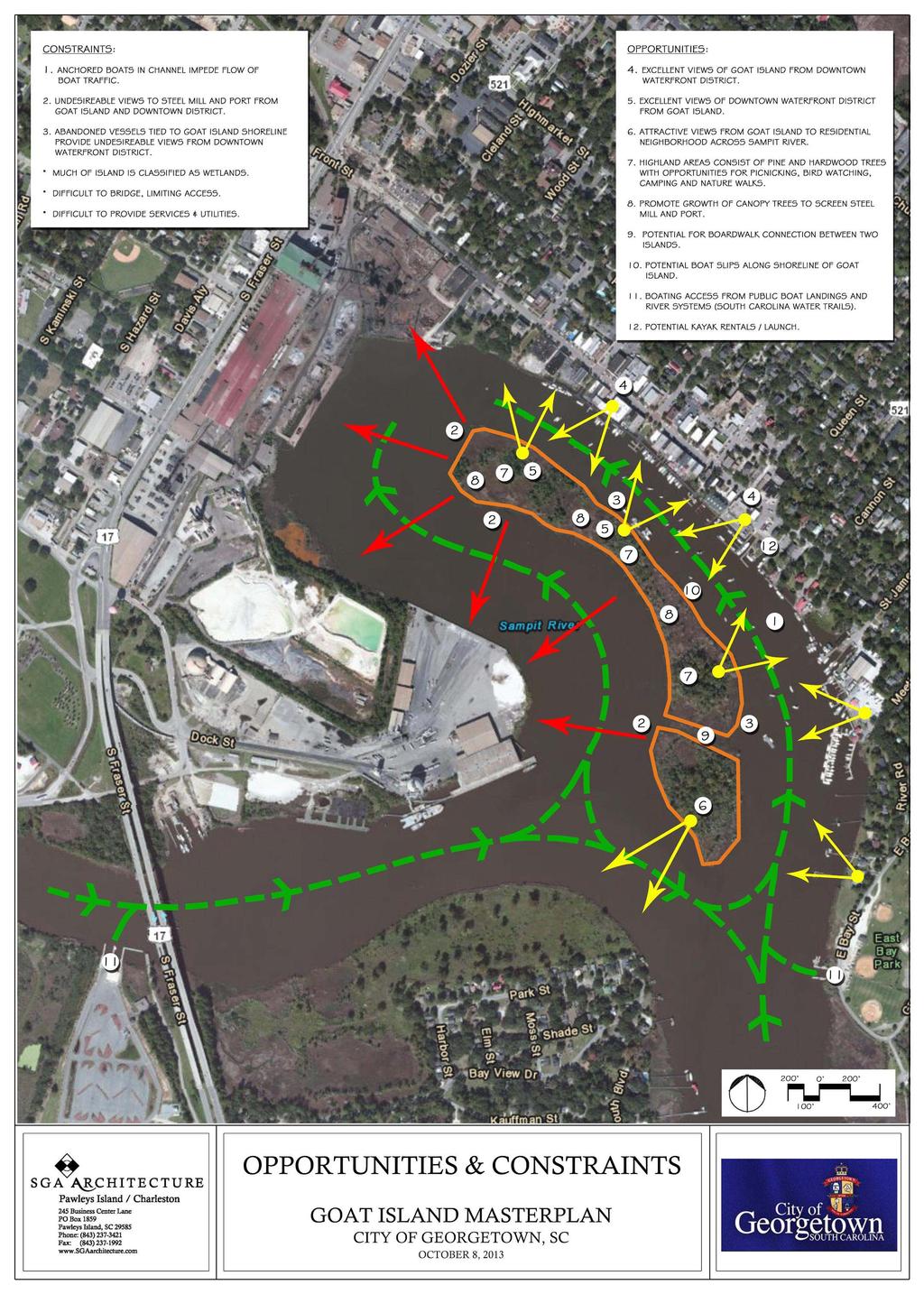
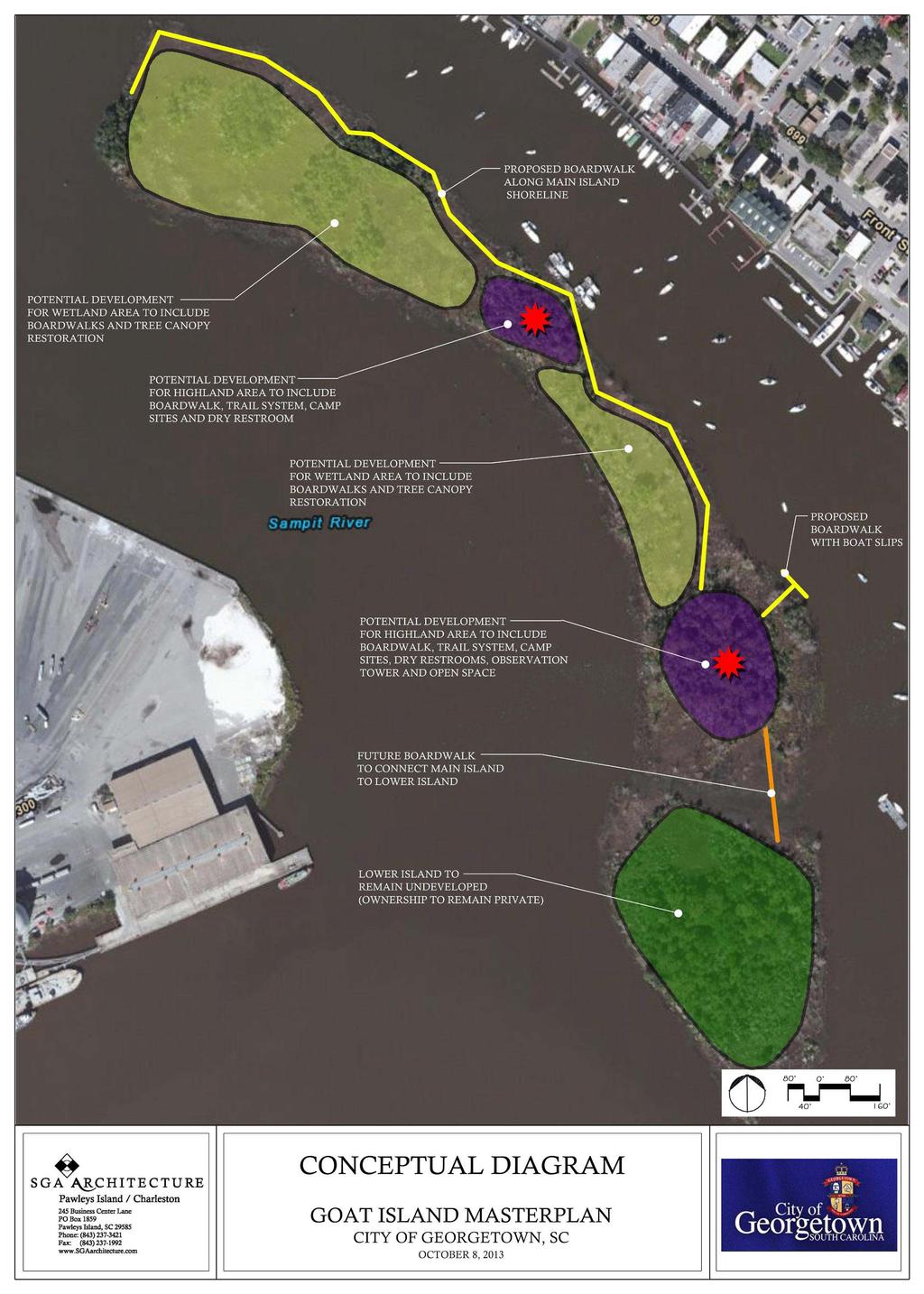
3 Goat Island is a small, wooded island that sits within the Sampit River, separating the Port of Georgetown and the Georgetown Historic District. Goat Island is, in reality, a series of wooded hummocks or smaller islands, connected together by low-lying wooded tracts. In fact, most of the land comprising Goat Island is actually regulated wetland, which would inhibit its future development. Goat Island was created by virtue of a dredging project, which was conducted near the beginning of the twentieth century. In order to provide better navigation to the port, and to the Sampit River, in general, a cut was created to eliminate a severe horseshoe bend in the river. The isolated remainder of highground became Goat Island. The name of the island presumably results from the goats which inhabited the island at one time; however, there are currently no goats on the island. Before being isolated as an island, the property was owned by the Atlantic Coast Lumber Company, one of the largest sawmills in the world in the nineteenth and early twentieth century. It is thought that some of the company s operations may have been conducted on Goat Island, which was then connected to the mainland. The Island was purchased as a speculative investment in the early nineteen nineties by Mr. Jerry Blackmon of Charlotte, North Carolina. Mr. Blackmon has numerous real estate interests in the City of Georgetown (the City) and Georgetown County. Prompted by the commercial development of the boating channel and the City of Georgetown s commercial district, coupled with a concern over how Goat Island would be developed, Mr. Blackmon made a proposal to the City. In short, Mr. Blackmon would donate most of the island to the City, provided it would prepare a master plan for the Island that met with Mr. Blackmon s approval, and would commit to developing the elements of the master plan at some point in the future. Mr. Blackmon desired to retain the southernmost piece high ground, consisting of approximately three acres, located at the mouth of the boating channel. On this basis, the City placed a Request for Qualifications, and SGA Architecture (SGA) was selected for the task of master planning the Island. SGA s liaison with the City was Mr. Chris Carter, the City Administrator. Mr. Carter was enormously helpful in guiding the process, and he provided many useful ideas, which subsequently became part of the masterplan. SGA also wants to thank Mayor Jack Scoville and the City Council for its interest, support, and facilitation of the planning effort.
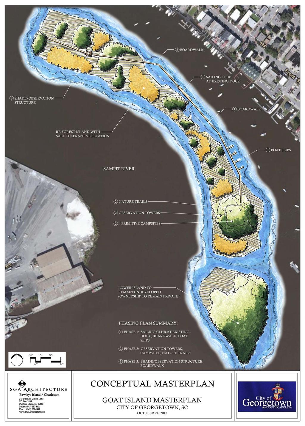
4 The Process The first step in the planning process was to assemble base maps, from which could be utilized in developing the masterplan. The City had a copy of a site survey prepared by the surveying and engineering firm, Stantec. This survey indicated property boundaries, wetland lines, and limited topography. SGA was also able to download satellite imagery from the Georgetown County GIS website. These two sources provided enough information for a base plan to be created. SGA next met with Mr. Blackmon and Mr. Blackmon s representative, Vernon Goode, in order to obtain programmatic direction. In this meeting, Mr. Blackmon suggested various types of passive recreation, including boardwalks, nature trails, and boat dockage and access. Mr. Blackmon also expressed concern over squatters and boaters tying up to the island, who were either transient or living on boats while anchored to the island. Mr. Blackmon was concerned about his riparian rights and the possibility of boaters mooring at the island to the detriment of the island itself. Abandoned boats, refuse, and lack of economic advantage were issues of concern to Mr. Blackmon. On this basis, Mr. Blackmon suggested that a walkway which ran along the perimeter of the island, rather than through the island, might form more of a barrier and would be easier to manage by the City in future years. He also believed that space for vessels to tie up could be economically advantageous for the City. SGA next turned its attention to the City itself, and in preparation, prepared a site analysis of Goat Island, titled Opportunities and Constraints, a copy of which is included in this document. One of the obvious opportunities afforded by Goat Island, in addition to recreational opportunities, was the Island s function as a visual buffer. The island separates the historic district and the commercial district from the more industrial and maritime functions relating to the port. SGA views this buffering quality significant to maintaining the view shed from the downtown and boardwalk areas of the historic district. Its demise would certainly have economic impact and would impact upon the quality of life of the City s residents. The public meeting was conducted on October 8, 2013, at the Georgetown City Hall, and the discussion was lively. It was noted that the recreational boating traffic had significant economic impact on downtown businesses. Sailboats and yachts traveling the intracoastal waterway make Georgetown an important stopover, and the opportunity for that business to increase in future years is significant. Moorage for the sailing club was suggested, and eventually included in the master plan. Many similar suggestions relating to the types of nature trails, boardwalks, and observation decks for birding and other passive recreation opportunities were discussed. Primitive Camping for a limited number of campsites was recommended. Connecting the island to the mainland was discussed, but ultimately discounted due to the significant cost and regulatory hurdles required for implementation. Armed with the combined input of the current landowner and community, SGA proceeded to develop a final conceptual masterplan for the island. The masterplan was presented to the City Council on October 28, Based upon the City s approval of the Conceptual Masterplan, a cost estimate was produced, which endeavored to define costs for the three phases in which construction and implementation are contemplated. The cost estimates were submitted to the City for its Council Workshop on December 5, This document represents the culmination and finalization of all elements of the Conceptual Masterplan for The City of Georgetown.
5
6
7
8 Goat Island Master Plan Estimate of Probable Costs Georgetown, South Carolina Prepared By: SGA Architecture URS Corporation Date: December 4, 2013 UNIT TOTAL DESCRIPTION QTY UNIT PRICE Const. Cost PHASE 1 A. Demolition/Site Preparation 1. Selective demolition of existing dock 1 LS $15, $15, Removal of abandoned boats at existing dock (By Others) 1 LS $0.00 $0 Demolition/Site Preparation Total: $15,000 B. Mobilization/Demobilization 1. Mobilization/Demobilization (pile driving rig) 1 LS $25, $25,000 Mobilization/Demobilization Total: $25,000 C. General Construction 1. Existing Dock Renovation (upfit to meet sailing club specifications) 1 LS $150, $150, ' Boardwalk w/ low voltage lighting (930'+/- length)* 930 LF $ $334, Pilings for 8' Boardwalk (2 piles per 16' LF) 116 EA $5, $638, ' Boat slip w/ low voltage lighting (4 total)* 200 LF $ $54, Pilings for 50' Boat Slips (1 Each) 4 EA $5, $22, ADA Gangway 1 EA $60, $60, Directional / Interpretive Signage 1 LS $5, $5, Island Reforestation 1 LS $20, $20,000 General Construction Total: $1,283,800 * Low voltage lighting powered via solar panels. SUB-TOTAL $1,323,800 15% Construction Contingency $198,570 PHASE 1 SUB-TOTAL $1,522,370 PHASE 2 A. Site Preparation 1. Selective clearing for nature trails & 4 primitive camp sites. 1 LS $5, $5,000 Site Preparation Total: $5,000 B. General Construction 1. 10'x10' Observation Towers w/ steel construction 2 EA $50, $100, Firepit at primitive campsite 4 EA $1, $6, ' Nature Trail - Mulch Surface (1,170'+/- Length) 1,170 LF $10.00 $11, Dry Restroom Facility (solar powered) 1 LS $20, $20,000 General Construction Total: $137,700 SUB-TOTAL $142,700 15% Construction Contingency $21,405 PHASE 2 SUB-TOTAL $164,105 PHASE 3 A. Demolition/Site Preparation 1. Selective site demolition 1 LS $5, $5,000 Demolition/Site Preparation Total: $5,000 B. Mobilization/Demobilization 1. Mobilization/Demobilization (pile driving rig) 1 LS $25, $25,000 Mobilization/Demobilization Total: $25,000 C. General Construction 1. 8' Boardwalk w/ low voltage lighting (1,200'+/- length)* 1,200 LF $ $432, Pilings for 8' Boardwalk (2 piles per 16' LF) 150 EA $5, $825, ADA Gangway 1 EA $60, $60, 'x20' Shade/Observation Structure (w/ metal roofing) 1 LS $60, $60, Directional / Interpretive Signage 1 LS $5, $5,000 General Construction Total: $1,382,000 * Low voltage lighting powered via solar panels. SUB-TOTAL $1,412,000 15% Construction Contingency $211,800 PHASE 3 SUB-TOTAL $1,623,800 PHASE 1 SUB TOTAL $1,522,370 PHASE 2 SUB TOTAL $164,105 PHASE 3 SUB TOTAL $1,623,800 TOTAL ESTIMATE OF PROBABLE COSTS $3,310,275 * Probable Costs are reflective of the Goat Island Conceptual Masterplan, dated October 24, Estimates of quantity and costs are preliminary due to unknown field conditions and future planning, and are subject to change. * Dredging for boardwalk construction is not included in this Estimate of Probable Costs, and shall be determined if needed at a later time. * An Environmental Impact Study was not available at the time during which this Estimate of Probable Costs was prepared. SGA Architecture and URS Corporation shall not be held responsible for site removal/remediation costs incurred as a direct result of an Environmental Impact Study performed on the subject property. Page 1
Project Location. Jay and Patty Baker Park and Gordon River Greenway Connector Bridge. Naples Beach Golf Club. Gordon River. East. Naples.
 Gordon River Project Location Naples Beach Golf Club East Naples Naples Naples Bay Evergreen Golf and Country Club and Gordon River Greenway Connector Bridge Gordon River Greenway CONNECTOR BRIDGE AND
DRAFT SCOPE OF SERVICES PEER REVIEW OF BAKER PARK. Request for Qualifications (RFQ)
") DRAFT SCOPE OF SERVICES PEER REVIEW OF BAKER PARK Request for Qualifications (RFQ) The following scope of services is presented for consideration and development of firm qualifications submittal. Some
DRAFT SCOPE OF SERVICES PEER REVIEW OF BAKER PARK Request for Qualifications (RFQ) The following scope of services is presented for consideration and development of firm qualifications submittal. Some
Popp s Ferry Causeway Park Back Bay Environmental Educational Center CASHIO COCHRAN LLC
 Popp s Ferry Causeway Park Back Bay Environmental Educational Center CASHIO COCHRAN LLC A LIMITED LIABILITY COMPANY Popp s Ferry Causeway Park Master Plan Prepared for: City of Biloxi Department of Parks
Preliminary Regulatory and Engineering
 Preliminary Regulatory and Engineering Overview For the Isle of Palms, South Carolina Prepared by: Applied Technology & Management, Inc. 941 Houston Northcutt Boulevard, Suite 201 Mount Pleasant, South
ASHTABULA COUNTY COASTAL MANAGEMENT PLAN
 Location Ashtabula County, Ohio Planning Grantwriting ODNR, Office of Coastal Management, $25,000 Local Match $25,000 Size 21 miles of coastal area Professional Services 2012 Project Team Randy Mielnik,
VIRGINIA KEY CONSENSUS MASTER PLAN
 VIRGINIA KEY CONSENSUS MASTER PLAN JULY 2010 Existing Conditions JULY 2010 STAKEHOLDER INTERVIEW PROCESS, January 18-22, 2007 PUBLIC MEETING #1: SITE INVENTORY AND ANALYSIS, March 29, 2007 PUBLIC MEETING
Las Colonias Park Master Plan
 2013 Las Colonias Park Master Plan City of Grand Junction June 2013 Introduction Las Colonias Park, a 101 acre parcel on the edge of the Colorado River south of downtown, was deeded to the City of Grand
HURON WATERFRONT DEVELOPMENT AND AMPHITHEATER
 AWARD WINNING PROJECT Location Huron, Ohio Architectural, Engineering, Site, Landscaping, Planning, Survey, Grant Administration, Construction Administration Cost $285,000 Amphitheater $300,000 Marina
Martin Pastucha, Director of Public Works Karen Ginsberg, Director of Community and Cultural Services
 Information Item Date: August 11, 2015 To: From: Subject: Mayor and City Council Martin Pastucha, Director of Public Works Karen Ginsberg, Director of Community and Cultural Services Reed Park Improvement
TASK FORCE MEETING #6 SUMMARY
 TASK FORCE MEETING #6 SUMMARY CITY OF REDWOOD CITY INNER HARBOR SPECIFIC PLAN Tuesday, January 14, 2013 7:00 P.M. 9:30 P.M. Seaport Conference Center, 459 Seaport Court, Redwood City, CA 94063 I. WELCOME
Don Narrows Workshop DRAFT MEETING REPORT Saturday, May 24, 2008 South Regent Park Recreation Centre
 Don Narrows Workshop DRAFT MEETING REPORT Saturday, May 24, 2008 South Regent Park Recreation Centre Introduction to the Workshop & this Report On Saturday, May 24, 2008 Toronto and Region Conservation
City Center Neighborhood Plan
 [1] City Center Neighborhood Plan As adopted by Ordinance No. 2014-09-049 and amended by Ordinance Nos. Formerly CBD Neighborhood as adopted by Ordinance No. 8868 and amended by Ordinance Nos. 8946, 9693,
City of Iowa City Department of Neighborhood and Development Services Department of Parks and Recreation Department of Public Works City Manager s
 RFP Pre-submittal meeting December 18, 2015 City of Iowa City Department of Neighborhood and Development Services Department of Parks and Recreation Department of Public Works City Manager s Office Background
Monday, October 5, THE LIGHTHOUSE, PIER 61 at CHELSEA PIERS, HUDSON RIVER PARK, NEW YORK CITY SPONSORSHIP DECK
 Monday, October 5, 2015 THE LIGHTHOUSE, PIER 61 at CHELSEA PIERS, HUDSON RIVER PARK, NEW YORK CITY SPONSORSHIP DECK ABOUT US Our Mission The Waterfront Alliance works to protect, transform, and revitalize
DRAFT MAP AMENDMENT FLU 04-4
 DRAFT MAP AMENDMENT FLU 04-4 SW 24 TH AVENUE ROADWAY CORRIDOR The University of Florida participates with the Metropolitan Transportation Planning Organization (MTPO) in its responsibilities for the continuing,
Port of Camas-Washougal Waterfront Trail Master Plan
 Port of Camas-Washougal Waterfront Trail Master Plan The Port s facilities are the products of its mission: To make strategic investments that enhance the community s quality of life by bringing jobs,
CITY OF SIGNAL HILL Cherry Avenue Signal Hill, CA
 CITY OF SIGNAL HILL 2175 Cherry Avenue Signal Hill, CA 90755-3799 September 3, 2013 AGENDA ITEM TO: FROM: SUBJECT: HONORABLE MAYOR AND MEMBERS OF THE CITY COUNCIL PILAR ALCIVAR-McCOY DIRECTOR OF COMMUNITY
Sanford/Lee County Technical Review Committee (TRC) DEADLINES & MEETING DATES
 DEADLINES & MEETING DATES") Sanford/Lee County Technical Review Committee (TRC) DEADLINES & MEETING DATES The following 2019 information is based on the information available to staff at the time of creation. Dates & time may change
Sanford/Lee County Technical Review Committee (TRC) DEADLINES & MEETING DATES The following 2019 information is based on the information available to staff at the time of creation. Dates & time may change
Terra Nova Rural Park Plan
 Terra Nova Rural Park Plan Part 1 Getting to know the land The Surrounding Area North Side Airport, River, Trail East Side - Residential West Side- Sturgeon Banks, West Dyke Trail South Side:Terra Nova
Grand River Ravines Georgetown Township
 Grand River Ravines Georgetown Township Project Description: The Grand River Ravines County Park property is composed of the 68-acre former Fillmore at the Bend Open Space purchased in 1999 and two more
PURPOSE AND NEED FOR ACTION PUBLIC SCOPING LETTER SILVER GLEN SPRINGS RECREATION ENHANCEMENT PROJECT. Ocala National Forest
 File Code: 1950/2300/2720 PUBLIC SCOPING LETTER SILVER GLEN SPRINGS RECREATION ENHANCEMENT PROJECT Lake George Ranger District Marion County, Dear Visitor: The of the has developed a proposal (Proposed
ELLIOTT HEADS STRUCTURE PLAN
 ELLIOTT HEADS STRUCTURE PLAN BACKGROUND This report has been prepared to provide an overview of the land that has been included in the Urban Footprint within the Wide Bay Burnett Regional Plan, September
The 21st Century Waterfront Executive Summary
 The 21st Century Waterfront Executive Summary May, 2002 Hargreaves Associates Schwartz Silver /Moffatt Nichol / Arcadis G&M Manufacturers East Manufacturers West Moccasin Bend Gateway Ross s Landing Park
Naomi Weiss, Executive Director, DBPA Jason Jeffries, Project Manager, City of Daytona Beach
 Naomi Weiss, Executive Director, DBPA Jason Jeffries, Project Manager, City of Daytona Beach Nottingham Plan 2002 Adopted Redevelopment Plan 2002 Riverfront Action Plan 2004 Downtown Vision Plan 2007
2. Would the proposed project comply with the Land Use map? 3. Would the proposed project require a rezoning? 4. What is the proposed zoning district?
 TOWN OF CHAPEL HILL Planning and Sustainability Department 405 Martin Luther King Jr. Blvd. Chapel Hill, NC 27514 www.townofchapelhill.org phone (919) 968 2728 Concept Plans are intended to be an opportunity
Summary of Changes in the DRAFT Rivers Project Natural Resource Master Plan from the 2001 approved plan to 2014 plan
 Summary of Changes in the DRAFT Rivers Project Natural Resource Master Plan from the 2001 approved plan to 2014 plan The entire Master Plan format and layout has been changed to comply with regulation
TASK FORCE MEETING #10 SUMMARY
 TASK FORCE MEETING #10 SUMMARY CITY OF REDWOOD CITY INNER HARBOR SPECIFIC PLAN Tuesday, April 8, 2014 7:00 P.M. 9:30 P.M. Seaport Conference Center, 459 Seaport Court, Redwood City, CA 94063 TASK FORCE
Preliminary Sketch Plan for Fort Hunter Park
 Preliminary Sketch Plan for Fort Hunter Park Public Presentation November 19, 2009 Dauphin County Parks and Recreation 100 Fort Hunter Road Harrisburg, PA 17110 (717) 599-5188 www.dauphinc.org THOMAS COMITTA
2. Would the proposed project comply with the Land Use map? 3. Would the proposed project require a rezoning? 4. What is the proposed zoning district?
 TOWN OF CHAPEL HILL Planning and Sustainability Department 405 Martin Luther King Jr. Blvd. Chapel Hill, NC 27514 www.townofchapelhill.org phone (919) 9682728 Concept Plans are intended to be an opportunity
Comprehensive Study N A G L E H A R T R A Y A R C H I T E C T U R E GILBANE BUILDING C O M P A N Y P R O J E C T M A N A G E M E N T A D V I S O R S
 N A G L E H A R T R A Y A R C H I T E C T U R E GILBANE BUILDING C O M P A N Y P R O J E C T M A N A G E M E N T A D V I S O R S BOE COW Meeting October 6, 015 Comprehensive Study North Shore School District
Pleasant Garden Community Center MASTER PLAN
 Pleasant Garden Community Center MASTER PLAN For the Town of Pleasant Garden North Carolina February 6, 2018 Adopted 1730 Varsity Drive Raleigh, NC 27606 919.233.8091 McKim & Creed Project #07083.0004
Arkansas River Corridor
 Planning for Access Welcome to the Access Project. This project is a recreational planning effort in response to an interest by regional communities along the Arkansas River corridor. The project plan
MASTER PLAN for the EARL NEWHOUSE WATERFRONT
 MASTER PLAN for the EARL NEWHOUSE WATERFRONT on RESERVOIR POND - CANTON, MA Community Meeting #2 - Thursday, January 11 th PROJECT INTRODUCTION Project Goals: To prepare a MASTER PLAN which develops the
ENVIRONMENTAL / OPEN SPACE
 INTRODUCTION OPEN SPACE RESPONSILBILITIES COMPREHENSIVE PARKS & RECREATION MASTER PLAN WATERFRONT PARK RESOURCED-BASED AND NEIGHBORHOODPARKS ACTIVITY-BASEDPARKS LANDSCAPING & VEGETATIONPROTECTION PROTECTING
Weston Conservation Commission
 Weston Conservation Commission Commission Roles and Responsibilities Laws that protect Wetlands What residents can do to protect wetlands and open space 1 Conservation Commission Made up of 7 volunteer
4.1 AESTHETICS EXISTING ENVIRONMENTAL SETTING ALAMITOS BAY MARINA REHABILITATION PROJECT CITY OF LONG BEACH
 4.1 AESTHETICS This section provides a discussion of the existing visual and aesthetic resources on site and in the surrounding area as well as an analysis of potential impacts from implementation of the
DISCUSSION TOPIC: ST JOHNS RIVER & ITS TRIBUTARIES (BPII) 2030 COMPREHENSIVE PLAN POLICES AND REGULATORY FRAMEWORK
 2030 COMPREHENSIVE PLAN POLICES AND REGULATORY FRAMEWORK") DISCUSSION TOPIC: ST JOHNS RIVER & ITS TRIBUTARIES (BPII) 2030 COMPREHENSIVE PLAN POLICES AND REGULATORY FRAMEWORK St. John s River & Its Tributaries Issue Summary: The St. Johns River is an important
DISCUSSION TOPIC: ST JOHNS RIVER & ITS TRIBUTARIES (BPII) 2030 COMPREHENSIVE PLAN POLICES AND REGULATORY FRAMEWORK St. John s River & Its Tributaries Issue Summary: The St. Johns River is an important
North Shore Trail. Council Meeting June 10, 2002
 North Shore Trail Council Meeting June 10, 2002 Process Guiding Principles Inventory and Analysis Preliminary Concepts (4) Final Concept Phasing Strategy Estimated Costs OVERVIEW Purpose: Prepare an overall
CONCEPT PLAN APPLICATION
 CONCEPT PLAN APPLICATION TOWN OF CHAPEL HILL Planning Department 405 Martin Luther King Jr. Blvd phone (919) 968-2728 fa (919) 969-2014 www.townofchapelhill.org Parcel Identifier Number (PIN): 9880267455
Burrowing Owl Habitat Project at the Albany Plateau. (a component project of the Gilman Street Playing Fields Project City of Berkeley) March 10, 2006
 March 10, 2006") Burrowing Owl Habitat Project at the Albany Plateau (a component project of the Gilman Street Playing Fields Project City of Berkeley) March 10, 2006 Submitted by The City of Berkeley Project history During
Burrowing Owl Habitat Project at the Albany Plateau (a component project of the Gilman Street Playing Fields Project City of Berkeley) March 10, 2006 Submitted by The City of Berkeley Project history During
Description of Preferred Alternative
 Chapter 2 Description of Preferred Alternative 2.1 Introduction This chapter of the programmatic Sammamish Town Center Sub-area Plan Final EIS provides a more detailed description of the Preferred Alternative
Town of Lyons Parks Flood Recovery Planning Process. Photograph courtesy of Ed Bruder
 Town of Lyons Parks Flood Recovery Planning Process Photograph courtesy of Ed Bruder Lyons Parks and Recreation Flood Recovery Update 1. Meadow Park Phase II - Project PW20B1 Estimated Completion: Summer
Public Meeting #3 May 9, 2009 MVVA Team
 Public Meeting #3 May 9, 2009 MVVA Team Welcome to the third Public Meeting for the Lower Don Lands Municipal Class Environmental Assessment (EA) Infrastructure Master Plan and Keating Channel Precinct
Purpose of Open House #3
 Public Meeting #3 May 9, 2009 MVVA Team Purpose of Open House #3 The main purpose of this Open House is to present and seek input on the: Evaluation of transportation and infrastructure design alternatives
10.0 Open Space and Public Realm
 10.0 Open Space and Public Realm 10.0 Open Space and Public Realm The Public Open Space System is comprised of: outdoor spaces available for public use that are either publicly owned (e.g., parks and
SHORELINE, FLOOD AND COASTAL DEFENCE MANAGEMENT PLANS
 These plans may provide opportunities as well as concern for recreational boating. They are currently being revised and consulted on. This document explains how we can engage in the process. Shoreline,
LAND USE PLAN 7. Housing
 21 LAND USE PLAN While the land uses that have historically dominated the Corridor itself have been industrial/commercial, the Master Plan proposes a shift to mixed-use redevelopment, complimented by a
Public Workshop 2 December 11, 2014 OLIN
 Public Workshop 2 December 11, 2014 OLIN TRIPLE IMAGE PANORAMA A NEW VISION FOR THE RIVERFRONT PROMENADE Burlington s Riverfront has historically been a defining character of the City s identity. This
City of Heath. Town Center Concept
 In the give-and-take of getting projects designed, financed, and approved, the famous refrain from the film Field of Dreams is heard often: if you build it, they will come. From the perspective of the
Abingdon Urban Path System
 Abingdon Urban Path System Transportation Enhancement Program Application (FY 2012-2013) Submitted by: Town of Abingdon,Virginia P. O. Box 789 133 West Main Street Abingdon, VA, 24212 November 1, 2011
Winter Island Park Public Meeting #1 Salem, Massachusetts
 Winter Island Park Public Meeting #1 Salem, Massachusetts Site Context The Willows Salem Center Dominion Power Station ti Marblehead Site Analysis and Programming Site Conditions Site Uses Site Structures
Appendix N. Preliminary Design
 Appendix N Preliminary Design Belfountain Dam and Headpond Class EA Preferred Alternative D4H5: Lower the spillway & backfill headpond & construct channel Preliminary Cost Estimate ITEM ITEM UNIT EST.
RE: Application for FERC Project No , Scott s Mill dam hydropower proposal
 RE: Application for FERC Project No. 14425, Scott s Mill dam hydropower proposal To Whom It May Concern: James River Association (JRA) is a conservation organization that has been solely dedicated to restoring
Mariposa Lakes. Planned Community. Project Overview. Stockton, CA
 Planned Community Stockton, CA Project Overview March 2007 Summary of Proposed Community is a master-planned community proposed for development on approximately 3,810 acres in southeast Stockton. In 2004,
RFP REQUEST FOR PROPOSALS CITY OF PORTSMOUTH, NH. DESIGN ENGINEERING SERVICES North Mill Pond Trail and Greenway
 RFP 61-18 REQUEST FOR PROPOSALS CITY OF PORTSMOUTH, NH DESIGN ENGINEERING SERVICES North Mill Pond Trail and Greenway Sealed Requests for Proposals, plainly marked RFP 61-18 Design Engineering Services
MILL POND OVERLOOK. A project of the Town of Oyster Bay. Prepared by Cameron Engineering & Associates, LLP
 MILL POND OVERLOOK A project of the Town of Oyster Bay Prepared by Cameron Engineering & Associates, LLP Funded in part through an EPF grant from the NYS Department of State Project Goals & Advisory Committee
MEMORIAL PARK MANAGEMENT PLAN
 MEMORIAL PARK MANAGEMENT PLAN Village of Elk Rapids, Michigan 2015 Developed by the Parks and Recreation Commission Planning Commission Approved, Village Council Approved, 1 Introduction The purpose of
Appendix E Preliminary Design
 Appendix E Preliminary Design 1 1 0+080 0+100 0+200 0+240 LEGEND PROPOSED POOL PROPOSED RIFFLE PROPOSED COIR CLOTH BANK TREATMENT PROPOSED VEGETATED STONE BANK TREATMENT PROPOSED VEGETATED BLOCK BANK TREATMENT
CHARLES COUNTY GOVERNMENT RFP NO POPES CREEK RAIL TRAIL DESIGN
 CHARLES COUNTY GOVERNMENT Department of Fiscal and Administrative Services Purchasing Division Telephone: 301-645-0656 July 7, 2015 RFP NO. 16-02 POPES CREEK RAIL TRAIL DESIGN ADDENDUM NUMBER ONE TO: All
FORT MISSOULA REGIONAL PARK
 FORT MISSOULA REGIONAL PARK Master Plan Refinement/ Design Development www.missoulaparks.org DHM Design/WGM Group December 3, 2008 Master Plan Report Fort Missoula Regional Park Guiding Principals i 6/14/01
CITY COUNCIL AGENDA REPORT
 CITY COUNCIL AGENDA REPORT Subject: DESIGNATED FLOOD LINE CARROT CREEK Recommendation(s) That Administration bring forward a Land Use Bylaw amendment in October 2014 establishing the Designated Flood Line
Community Conversation. Thursday, March 30, James St N 7:00 pm 9:15 pm
 Community Conversation Thursday, March 30, 2017 294 James St N 7:00 pm 9:15 pm Start Time Agenda item Presenter / Facilitator 7:00 Welcome & Agenda Overview Diedre Rozema (City of Hamilton) Participation
JACKsON STREET PIER CONCEPTUAL DESIGN PACKAGE SEPTEMBER 21, 2017
 JACKsON STREET PIER CONCEPTUAL DESIGN PACKAGE SEPTEMBER 21, 2017 JACKsON STREET PIER Process outline DESIGN PROCESS OVERVIEW: Sandusky s Jackson Street Pier Conceptual Design process included input from
6.0 Development of Amenities,
 6.0 Development of Amenities, conservation of architectural heritage and other features This chapter outlines the Area's significant potential to provide for amenities of city wide and local importance
C ity of Grande Prairie Development Services Department
 C ity of Grande Prairie Development Services Department FAIRWAY DEVELOPMENT OUTLINE PLAN OP 08 09 Approved April 6, 2009 Prepared by: Focus Corporation Table of Contents 1.0. Introduction 2 3 1.1. Plan
SAN FRANCISCO. and. A Sampling of Installations in San Francisco, California
 SAN FRANCISCO and A Sampling of Installations in San Francisco, California Buena Vista Park City and County of San Francisco It was known as Hill Park in 1867 when San Francisco s Committee on Outside
Mitchell Ranch South MPUD Application for Master Planned Unit Development Approval Project Narrative. Introduction
 Mitchell Ranch South MPUD Application for Master Planned Unit Development Approval Project Narrative Introduction Mitchell Ranch South is a proposed single family (detached) residential development on
River Bend Area Plan Map Amendment ARPP Analysis Camp Fire Day Camp November 20, 2014
 Regional Parks Department Jeffrey R. Leatherman, Director County of Sacramento Attachment 2 Divisions Administration Golf Leisure Services Maintenance Rangers Therapeutic Recreation Services River Bend
Alderson, West Virginia. Prepared for the Town of Alderson. Strategic Riverfront Enhancement Plan
 Alderson, West Virginia Prepared for the Town of Alderson Strategic Riverfront Enhancement Plan March 2018 Strategic Riverfront Enhancement Plan Alderson, West Virginia Prepared for: Alderson Main Street
Planning for Waterfront Communities
 Planning for Waterfront Communities Redevelopment Ready Communities Supplemental Training Program OFFICE OF THE GREAT LAKES Waterfront Community Best Practices and Guidelines New supplemental criteria
NORTH CLAYMONT AREA MASTER PLAN COMMUNITY WORKSHOP #1 FEBRUARY 3, 2016
 NORTH CLAYMONT AREA MASTER PLAN COMMUNITY WORKSHOP #1 FEBRUARY 3, 2016 1. Introduction To the team and to the Plan Planning Partners The Claymont Community WILMAPCO New Castle County Claymont Renaissance
OPPORTUNITIES AND CONSTRAINTS - OXBOW PARK ENTRANCE AND PUT-IN
 OPPORTUNITIES AT OXBOW EXISTING WETLANDS Site is undeveloped and we can design a park that works well from the start. SAND BEACH Potential to eliminate invasive species. DEBRIS (CONCRETE, OLD CARS) VEGETATION
City of Edmonton. Walterdale Bridge Replacement and Approach Roads Evaluation. Concept Planning Study. Final Report
 City of Edmonton Final Report Walterdale Bridge Replacement and Approach Roads Evaluation April, 2011 Walterdale Bridge Replacement and Approach Roads Evaluation Final Report April 2011 Acknowledgement
2.1 Location and Size
 2.0 Context 7 2.1 Location and Size The Saanich Penninsula The study area is centrally located within the Town boundaries on the east side of Highway 17, which runs through Sidney in a north-south direction.
SAN MARTIN BOULEVARD OVER RIVIERA BAY PROJECT DEVELOPMENT & ENVIRONMENT (PD&E) STUDY
 STUDY") KICK-OFF PRESENTATION SAN MARTIN BOULEVARD OVER RIVIERA BAY PROJECT DEVELOPMENT & ENVIRONMENT (PD&E) STUDY PROJECT IDENTIFICATION NUMBER (PID): #001036A May 13, 2015 1 2 PROJECT LOCATION PROJECT HISTORY
KICK-OFF PRESENTATION SAN MARTIN BOULEVARD OVER RIVIERA BAY PROJECT DEVELOPMENT & ENVIRONMENT (PD&E) STUDY PROJECT IDENTIFICATION NUMBER (PID): #001036A May 13, 2015 1 2 PROJECT LOCATION PROJECT HISTORY
T H A T E V E R Y O N E
 B R I N G I N G C H A N G E T H A T E V E R Y O N E C A N F E E L. AT CHW, we survey, plan, design, engineer, administer and inspect with a purpose: to positively transform the communities we serve. From
Re: Application Type: Proposed Highlands Redevelopment Area Designation
 CHRIS CHRISTIE Governor KIM GUADAGNO Lt. Governor State of New Jersey Highlands Water Protection and Planning Council 100 North Road (Route 513) Chester, New Jersey 07930-2322 (908) 879-6737 (908) 879-4205
Recreation and Open Space Vision: To be a place where open space for passive and active recreation is an integral part of development and growth.
 Chapter 6. RECREATION AND OPEN SPACE Recreation and Open Space Vision: To be a place where open space for passive and active recreation is an integral part of development and growth. 6.1 OVERVIEW OF RECREATION
SITE PLAN (REVISED 8/13/18) l. Development Data Table
 l. Development Data Table") SITE PLAN (REVISED 8/13/18) l. Development Data Table a. Site Acreage: 9.25 b. Tax Parcels included in rezoning: #108-081-07 and #108-081-23 c. Existing Zoning (including overlays and vesting): R-3 (see
SITE PLAN (REVISED 8/13/18) l. Development Data Table a. Site Acreage: 9.25 b. Tax Parcels included in rezoning: #108-081-07 and #108-081-23 c. Existing Zoning (including overlays and vesting): R-3 (see
Drexel, Barrell & Co.
 Drexel, Barrell & Co. December 21, 2018 Engineers/Surveyors Boulder Colorado Springs Greeley 3 South 7 th Street Colorado Springs, Colorado 80905-1501 719 260-0887 719 260-8352 Fax El Paso County Planning
WELCOME. Land North of STEVENAGE. We would like to thank you for attending our public exhibition today.
 WELCOME We would like to thank you for attending our public exhibition today. The purpose of this event is to share our proposals and hear your thoughts on our ideas. Members of the project team are on
FIRST AMENDMENT WATERSHED MANAGEMENT AREA 16 MASTER PLAN
 FIRST AMENDMENT WATERSHED MANAGEMENT AREA 16 MASTER PLAN City of Sea Isle City 233 JFK Boulevard Sea Isle City, New Jersey 08243 609-263-4461 (phone) 1962 2016 LEONARD C. DESIDERIO, MAYOR ADMINISTRATION
Town Centre Master Plan Sub-Committee Meeting 23/03/2017
 PRESENT Members: Councillor Geoffrey Hawkins (Chair) Councillor Michael Cusato Jeffery Sharp (Director Infrastructure and Asset Management) Rebecca Doblo (Landscape Architect) Jeff Gillespie (CBD Landowner)
OVERMOUNTAIN VICTORY TRAIL BURKE CALDELL CORRIDOR FEASIBLITY STUDY REQUEST FOR QUALIFICATIONS CALDWELL COUNTY PATHWAYS
 OVERMOUNTAIN VICTORY TRAIL BURKE CALDELL CORRIDOR FEASIBLITY STUDY REQUEST FOR QUALIFICATIONS CALDWELL COUNTY PATHWAYS Caldwell County Pathways along with our co-partners City of Lenoir, Town of Gamewell,
BRADENTON RIVERWALK EXPANSION MASTER PLAN
 BRADENTON RIVERWALK EXPANSION MASTER PLAN INTRODUCTION & AGENDA Process Update Community Engagement Summary Center for Active Design (CfAD) Recommendations Context and Existing Conditions Master Plan Alternatives
GRAND COUNTY Planning Commission April 27, :00 P.M. Regular Meeting GRAND CENTER North End Meeting Room 182 No. 500 W.
 Type of Meeting: Facilitator: Attendees: Regular Meeting Dave Tubbs, Chair GRAND COUNTY Planning Commission April 27, 2016 6:00 P.M. Regular Meeting GRAND CENTER North End Meeting Room 182 No. 500 W.,
Bourne Downtown Site Planning
 Prepared for: The Town of Bourne, MA In Cooperation with: Bourne Financial Development Corporation Prepared by:, Inc. June 24, 2009 Table of Contents Introduction and Summary... 1 Site Existing Conditions...
SUMMARY. Support the Southeast Arkansas Regional Intermodal Facility.
 SUMMARY THE I-69 LOCATION STUDY The proposed I-69 Location Study from El Dorado to McGehee, Arkansas, represents one section (Section of Independent Utility No. 13) of the nationally designated I-69 Corridor
Cohasset Municipal Harbor Plan Public Meeting #1. Harriman GEI Consultants FXM Associates May 31, 2018
 Public Meeting #1 Harriman GEI Consultants FXM Associates Agenda Welcome and Introductions Planning Study: Purpose and Process Municipal Harbor Planning 101 Existing Conditions Creating a Vision for the
Academics Efficient use of space will be used to enhance investments in new pedagogies such as active learning classrooms.
 Goals and Assumptions Physical Planning Goals and Objectives The guiding principles of this Master Plan were developed in consultation with various constituencies that make up the NMSU community and were
SCTPO Project Summary September 2014
 A1A MULTIMODAL CORRIDOR PLANNING AND ENGINEERING ANALYSIS Florida Department of Transportation SCTPO Project Summary September 2014 PRESENTATION FOOTER Meeting Agenda What We Plan To Do Project Background
City of Grande Prairie Development Services Department KENNEDY DEVELOPMENTS LTD. OUTLINE PLAN OP-09-01
 City of Grande Prairie Development Services Department KENNEDY DEVELOPMENTS LTD. OUTLINE PLAN OP-09-01 July 27, 2009 TABLE OF CONTENTS 1.0 Introduction... 1 1.1 Plan Area Location & Context... 1 1.2 Ownership
138 ATTACHMENT 17. DEPARTMENT OF THE ARMY WlLMlNGTON DISTRICT, CORPS OF ENGINEERS
 138 ATTACHMENT 17 DEPARTMENT OF THE ARMY WlLMlNGTON DISTRICT, CORPS OF ENGINEERS B. EVERETT JORDAN DAM AND LAKE P.O. Box 144 MONCURE, NORTH CAROLINA 27559 April 11, 2007 Mr. Scott Radway Radway Design
Chapter 9: Economic Development
 Chapter 9 Economic Development Goal To embrace a stable, prosperous business environment focused on industry diversity, yielding family income sufficient to support education, recreation, social and cultural
Pinellas County Greenways
 Pinellas County Greenways USING GREENWAYS TO LINK OPEN SPACES The Florida Greenways Commission has defined a greenway as...a corridor of protected open space that is managed for conservation and/or recreation.
Dauphin Island s East End Beach and Barrier Island Restoration Project. April 16, :00 PM Dauphin Island Sea Lab, Shelby Hall
 Dauphin Island s East End Beach and Barrier Island Restoration Project Town of Dauphin Island, Alabama April 16, 2015 6:00 PM Dauphin Island Sea Lab, Shelby Hall Team Introduction South Coast Engineers
LANGAN QUALIFICATIONS FOR THE MORGAN COMPANIES
 LANGAN QUALIFICATIONS FOR THE MORGAN COMPANIES CONTACT Arlington Virginia 1300 Wilson Boulevard Suite 450 Arlington VA 22209-2323 571.366.6800 571.366.6801 CONTACT Louise Pretzman 571.366.6826 lpretzman@langan.com
MAYFIELD WEST SECONDARY PLAN PHASE 2
 MAYFIELD WEST SECONDARY PLAN PHASE 2 Public Open House #3 February 25, 2010 Draft Preferred Land Use Scenario TOWN OF CALEDON PLANNING & DEVELOPMENT DEPARTMENT Open House Agenda TOWN OF CALEDON 1. Welcome
6 August 11, 2010 Public Hearing APPLICANT AND PROPERTY OWNER: CAVALIER GOLF AND YACHT CLUB
 6 August 11, 2010 Public Hearing APPLICANT AND PROPERTY OWNER: CAVALIER GOLF AND YACHT CLUB REQUEST: Conditional Use Permit (outdoor recreational facility) STAFF PLANNER: Faith Christie ADDRESS / DESCRIPTION:
Request for Proposals
 Request for Proposals Charlestown Navy Yard Infrastructure Assessment Engineering Services The Boston Redevelopment Authority ( BRA )/Economic Development Industrial Corporation ( EDIC ) is issuing a Request