THE BOMBAY GREENWAY PROJECT
|
|
|
- Solomon Singleton
- 6 years ago
- Views:
Transcription
1


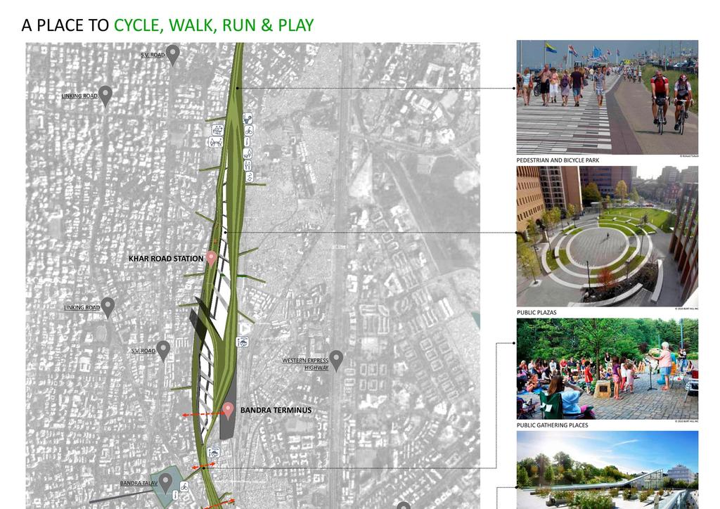
2 CURRENT ISSUES IN THE CITY The problem of the east-west divide 12 deaths daily, 4000 a year! Road congestion Over crowded railway stations & trains Lack of public spaces Lack of dedicated lanes for pedestrians/cyclists Limited interaction space Water logging on the railway tracks Depleting green cover Curbed pedestrian movement and increased traffic due to overcrowding of footpaths DAHISAR MULUND MANKHURD Impossible East West connections Crowded foot-over-bridges CHURCHGATE VT RAILWAY STATIONS RAILWAY LINE Crowded stations 12 deaths everyday due to trespassing THE EAST - WEST DIVIDE IN BOMBAY The railways run through the city like a river: long & linear holding the city together like a spine! Unfortunately, the City stands divided into East & West, the South & West being the more exclusive, closer to the developed seafront. All peak hour travel is North-South in the morning & South-North in the evening.


3 PUBLIC SPACES Foot paths crowded with hawkers The Great Crossing: Crowded Foot-over Bridges Foot paths crowded with hawkers Foot over bridge or Chicken coop? The only true everyday public spaces that Bombay has presently are the footpaths; brimming with activity, but not satisfying the function they were originally meant to perform. Foot paths have become informal spaces with hawkers restricting the movement of pedestrians. Bombay streets have practically no cycling tracks, or lanes for people using non-motorized modes of transport. Current scenario: a city deprived of recreational space - less than 1 sq m/person of open public space in a city of over 20 million residents HOW Can we create about 1000 acres of green space?


4 THE CONCEPT The Greenway created above and adding value to the existing railway lines, an environment friendly green transport + leisure solution could turn Bombay into a truly 21 st century city in terms of green space & connectivity. + = Existing Train Tracks & Elevated Pipe Lines Green The Bombay Greenway No cars, only people, trees & nature! + = Freeway Podium Garden The Bombay Greenway
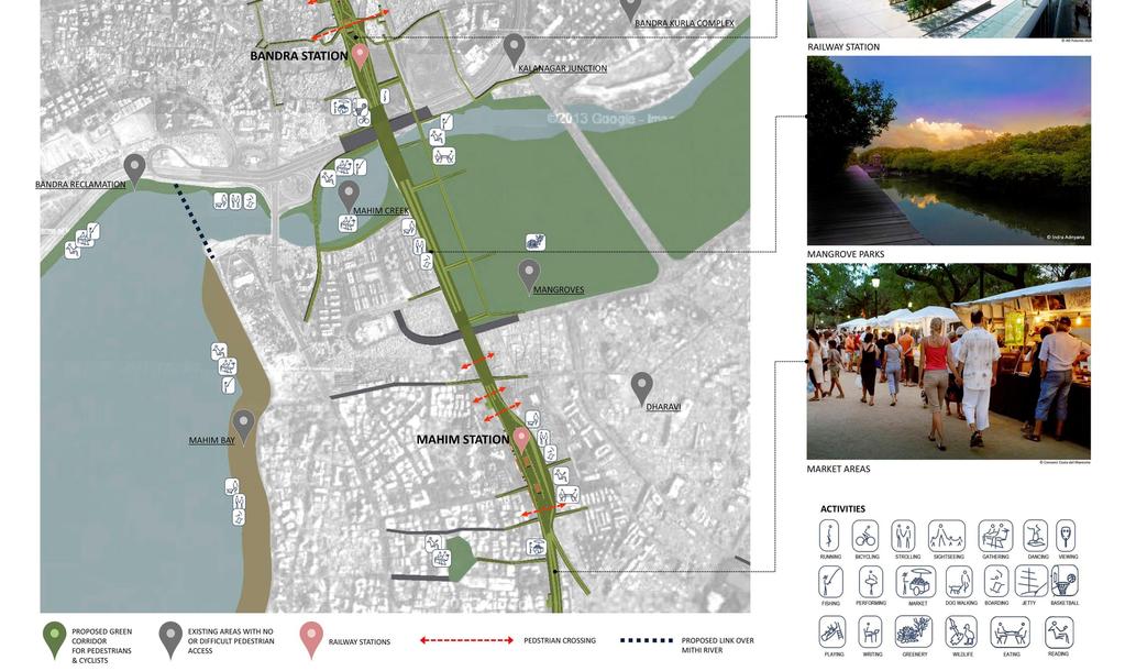
5 THE DESIGN The Greenway allows for a multiplicity of uses that a modern city like Bombay should expect from its public spaces: the railways double up as a vibrant park for commuters and visitors, cultural and retail re-invigoration, E-W connectivity, environmental restoration, green transport. Churchgate to Virar : km Mumbai CST to Thane : km Mumbai CST to Mankhurd : km Minimum width along entire stretch 25m Source:

6 THE IMPACT Creating a brand new, oxygen-generating river of green; the lungs of the city. The proposal aims to offer the people of Bombay a dynamic & engaging public destination addressing elements of green transport, culture, health & leisure. 114 km railway line = 114 km green space (Churchgate to Virar : km + Mumbai CST to Thane : km + Mumbai CST to Mankhurd : km) Minimum width along entire stretch 25m : Average width along entire stretch 35m Base Image HandHeld Films

7 Base Image HandHeld Films 1000 acres of open space 7.7 million commuters daily! Prevent people dying daily!
 16.8 4 1250 74.4 Orange Gate elevated section (part of the Eastern Freeway) 9.3 4 750 80.7 3 Panvel Elevated Road (2012) 2.4 4 139 58.")

8 THE GREENWAY IN FIGURES No. Name of Project Length Width Total Cost Cost /km km lanes Rs (crore) Rs (crore) Recently completed Projects: 1 Milan Subway Flyover (2013) The Eastern Freeway (2013) Orange Gate elevated section (part of the Eastern Freeway) Panvel Elevated Road (2012) Rajiv Gandhi Sea Link Under Construction Projects: 5 Santa Cruz Chembur Link Road Elevated Sahar Road Future Projects: 7 Pedder Road Flyover Worli- Haji Ali Sea Link Bandra- Versova Sealink Coastal Road Note: All projects in Bombay JJ FLYOVER, Bombay The Bombay Greenway Project : calling for alternative modes of transport & better connectivity Unlike the above mentioned projects, The Bombay Greenway is not designed for cars, but for people & public open spaces that communities can thrive in. It is designed for the future, for green active modes of transport that reduce carbon footprint in the city. The cost of construction would be approximately equivalent to that of a 114km long six lane flyover. Instead of a bituminous or concrete surface, it would have a landscaped surface, totally traffic & stress free. The entire stretch would also be designed to carry all essential services (electrical & gas pipe lines, water supply & communication lines). It will also be a source of revenue for the railways, create retail spaces, generate tourism and improve & increase the value of all the properties along the railway tracks. Cost calculation: Cost of construction = Rs.120 crores per km, as per a 6 lane flyover, based on calculations derived from the published cost of construction of the elevated road of the Eastern Freeway & the Milan Flyover in Bombay (both 2013). Total estimated cost of the project = Rs CR. Cost of construction = Rs.33,000 per sq.m, based on calculations derived from the published cost of construction as per new pre-fabricated methods. Conventional methods cost about Rs.12,000-15,000 per sqm. Total estimated cost of the project = Rs.9405 CR. There is NO land acquisition cost, the areas considered are only the ones above the current railway tracks. THE BOMBAY GREENWAY

9 WATER LOGGING WATER HARVESTING PRESENT SITUATION 340 Central Railway & 20 Western Railway services cancelled on16 June 2013 due to waterlogged tracks This is a common scenario in the monsoon, every year! CHANGES PROPOSED BY THE BOMBAY GREENWAY The Bombay Greenway Project plans to change WATER LOGGING the current day scenario that causes endless delays, diseases and unnecessary troubles into WATER HARVESTING a positive way to bring about change, not just a solution to the water logging, but a positive fallout of the Bombay Greenway Project, a well-planned and well executed design for the city and for its people The Bombay Greenway Project would also positively impact the railways: Reduced Heat load that would allow for easy & effective air conditioning Easy East-West Connectivity resulting in no deaths due to trespassing on tracks Trains travel would consequently be more comfortable and services would run on time. Delays and cost overruns and accidents would be a thing of the past. Source : Times of India, June 17, 2013 SHIVAJI PARK TO GET ITS OWN WATER HARVESTING SYSTEM The Environmental Minister gives final clearance for the 16 crore project which will help save the city 1lakh litres of water everyday Source :Mumbai Mirror, 13 May 2013 WATER HARVESTING POTENTIAL The Bombay Greenway will be a minimum of 917 acres green space with a potential water harvesting capacity of 7400 million litres. This would be enough not only to keep the project self-sustainable, but also to feed neighbouring areas with sufficient water for the whole year. Shivaji Park : 28 acres The Bombay Greenway : 1000 acres 200 million litres 7400 million litres
 = the no.")
10 RAILWAY STATIONS The number of citizens using public projects such as highways and terminals: Bandra-Worli Sea Link The Eastern Freeway Chatrapati Shivaji International Airport Thane Railway Station The Bombay Greenway Project 40,000 vehicles per day 24,000 vehicles per day 84,000 people per day 654,000 people per day 7.7 million people per day (minimum) = the no. of daily commuters on the railways plus newly-generated tourists, cyclists & leisure-oriented public The Railway Stations in Bombay There are 28 railways stations on the Western Line, 19 on the Central Line and 15 on the Harbour Line that are under consideration in The Bombay Greenway Project a total of 59 railway stations handling over 7.7 million people daily! Churchgate to Virar : km : Western Line: 28 railway stations Mumbai CST to Thane : km : Central Line: 19 railway stations (Dadar duplicated) Mumbai CST to Mankhurd : km : Harbour Line: 12 railways stations (CST & Kurla duplicated) As of June 2013, not one railway station has an escalator. Thane will be the first. Not one has a lift! Every mall in Bombay has escalators and lifts. The Times Of India, 19 May 2013 The image alongside from the newspaper shows the traffic at each station, each of which handles more people by far than the Bombay Airport!!! Let s spend public money where it makes a difference! Urban parks should be integrated into our living, working and commuting spaces The Greenway will provide conducive environment for active modes of transport with flat and stress-free, tree-lined shaded pathways & zero-carbon transportation options; So you can Run/Cycle/Walk/Skate your way to work! As a result of the Bombay Greenway Project, each and every station will be upgraded and better the life of the everyday commuter and citizen!

11 an upgraded railway station a sprawling urban park


12 THE RAILWAYS How does the Bombay Greenway benefit the Railways? The proposal does not do away with the existing railway system, instead it chooses to improve the interconnectivity, upgrade all existing railway stations, & create the potential for newer stations. Newly created retail spaces would bring great profit to the railways: cafés, restaurants, shops All stations would be elevated; platforms & trains services would be unaffected (see image below) All ticketing & entry could be modernised & security improved. Railway crossing accidents would be reduced; currently about 12 people die daily (4400 per year) while crossing railway tracks! Rain water lost yearly could be harvested; incidents of flooding could be controlled. The existing overhead equipment could be updated & laid under the Greenway, eliminating expensive accidents that are currently common Sound pollution due to the trains could be better contained & dramatically reduced. Heat gain on the trains could be reduced, allowing for more effective & economical air-conditioning These dedicated corridors would allow for faster & better train services. Commuters comfort & train experience would improve significantly The Railway Station sectional View 1. THE NEW AGE RAILWAY STATION ON THE GREENWAY 2. BICYCLE & PEDESTRIAN PATHWAYS 3. ACCESS TO THE RAILWAY STATION FROM THE GREENWAY 4. EXISTING RAILWAY PLATFORMS 5. POSSIBLE PLATFORMS FOR METRO TRAIN (FUTURE EXPANSION)

13 An upgraded railway station that doubles up as an urban park will greatly improve the daily commute by train, providing upgraded facilities to accommodate the predicted increase in passenger numbers: Cleanliness at the station Organised entry and exit points Larger circulation areas, open plazas A number of ticket counters Signage / Clarity in announcements Availability of parking space Cafes, restaurants, shops (revenue) Drinking water facilities Toilets for gents and ladies Waiting rooms, lighting, fans, telephones, turnstiles Facilities for the physically challenged, elevators, ramps, lifts, etc. Easy and accessible complaint handling mechanisms THE NEW AGE GREEN RAILWAY STATION ON THE GREENWAY (eg. BANDRA STATION, WR) 1. RAMP ACCESS TO THE GREENWAY 2. SKYWALK ACCESS TO THE GREENWAY 3. STAIRCASE ACCESS TO AND FROM THE STATION 4. SKYLIGHT FOR THE RAILWAY STATION ON THE GREENWAY 5. GREENWAY RAMPING UP TO AVOID DISRUPTION IN CYCLISTS MOVEMENT 6. GREENWAY ACCESS TO THE RAILWAY STATION

 An elevated park for")

14 CASE STUDIES PROMENADE PLANTÉE, Paris, France 4.7km long, 7m wide Elevated Viaduct converted into the first urban linear park For pedestrians & cyclists Opened to the public in 1994; Became a landmark in Paris THE HIGH LINE, New York, USA 2.33km long, 7m wide Unused elevated freight railway line, converted into a green urban park (third phase under construction) An elevated park for pedestrian only part promenade, part town square, part botanical garden. Opened to the public in Huge success, revamped the whole area, became a landmark in the city BARI CENTRALE COMPETITION WINNER, Bari, Italy 3km long This competition winning entry was announced on 24 th of April, 2013 An elevated park over the track. For pedestrians & cyclists Stretches over an area of 78 hectares and is centred around a large park that will pass over the railway and offer promenade views over the city and the sea.


15 SCALE STUDIES The Bombay Greenway compared with major open spaces at local & international level MAHALAKSHMI RACE COURSE THE BOMBAY GREENWAY HYDE PARK, LONDON, ENGLAND


16 THE CITY How does the Bombay Greenway benefit the City and the Environment? Makes people once again walk, run & cycle - instils a healthy lifestyle Makes public spaces green & accessible to anyone anywhere in the city Re-introduces active modes of transport ; cycle sharing scheme Bridges the east-west divide, currently dictated by the over ground railway system Reduces traffic congestion & air pollution Addresses the city's needs for more open spaces that are both attractive & safe Carries major services: electrical, gas pipe, water supply & communication lines Creates spaces for leisurely activities (family outings, picnics, etc.) Creates spaces for the arts: public performances, art installations, exhibitions Creates spaces for daily markets Introduces the concept of urban farming Creates a safe & secure environment Creates panoramic city views Enhances local biodiversity: indigenous trees & bird population. Imagine more than 1,00,000 trees on the Greenway an urban forest! environmental sustainable design features: water conservation and reuse, on-site energy production, smart technology for control of lighting and shading. The Greenway is a complete self-sustainable model that will improve Mumbai's infrastructure and become a landmark in the city PRESENT SITUATION CONGESTED ROADS OVERCROWDED TRAINS MOTORISED MODES OF TRANSPORTATION UNSAFE TRAVEL CULTURE PROPOSED SITUATION BROADWALK VISTAS SHADED GREEN BICYCLE TRACKS SAFE AND STRESS FREE TRAVEL Changing the way Bombay travels - ACTIVE MODES OF TRANSPORTATION


17 UPGRADING EVERYONE S LIFESTYLE The Greenway provides connectivity and accessibility. It will no longer be a trek to get to a park. The Greenway is accessible from your local railway station and anywhere else across the city. Connections in several areas have been proposed, (encouraging East- West inter-connectivity as well), with more to follow, allowing for a system of interchangeable modes of transport with government & public participation. This will allow a person to walk, cycle, use the train etc. to his destination without owning any means of transportation but having full access to them. Of course, the Greenway is beyond basic transportation needs. It also caters to the leisure needs of a growing city. The Greenway is active through the day; Mornings - commuters & fitness enthusiasts; Mid-day - lunch goers; Late evenings commuters, meetings, catching up with friends; Weekends for family outings. 7.7 million people per day (minimum) = the no. of daily commuters on the railways plus newly-generated tourists, cyclists & leisure-oriented public more transportation choices & reduced travel time on The Bombay Greenway The Railway Experience is greatly enhanced, increased facilities provided on the site will transform it into an exciting destination rather than just a transitory transport hub.
18
19
20 MAHALAXMI PROPOSAL Connecting Haji Ali to Mahalaxmi Race Course, Mahalaxmi railway station & Jacob Circle via a green walkway A beautiful, accessible city centre More green public spaces for communities to thrive in; moreover, traffic would be smoother, there would not be any trespassing, as cars would go underground, while the open space will belong to the people. SUSTAINABLE URBAN MOBILITY PLANNING FOR THE PEOPLE


21 WEST COAST MAHALAKSHMI RACE COURSE EAST COAST HAJI ALI PROMENADE WILLINGDON SPORTS CLUB RANI BAUG NARIYALWADI HAJI ALI MAHALAXSHMI RACECOURSE JACOB CIRCLE BYCULLA ZOO MbPT SEA BOARD Connecting Haji Ali to Mahalaxmi Race Course, Mahalaxmi railway station & Jacob Circle via a green walkway: to satisfy the mobility needs of people for a better quality of life and to give the public complete access to open spaces, encouraging active interchangeable modes of transport. Creating a landmark in the city, with street furniture, landscaping, public performances, installation art, public exhibitions, etc.

 and the proposed Arabian Sea promenade on the western end These Greenways would result in : increasing the recreational opportunities within the community by improving links")
22 WEST COAST km CENTRAL LINE 6 8 EAST COAST 2 min 0.6 km 2 13 min 4 min 4 min 13 min 4 min 1 km 1 km 1 km HAJI ALI 2. WILLINGDON GOLF COURSE 3. MAHALAXMI RACE COURSE 4. MAHALAKSHMI RAILWAY STATION 5. JACOB CIRCLE 7. NARIYALWADI 6. BYCULLA ZOO 8. Mbpt PORT GREEN CORRIDOR BRIDGING THE EAST-WEST DIVIDE OF THE CITY PROPOSED GREEN SPACES EXISTING GREEN SPACES Connectivity is provided between mass transit modes Jacob Circle (Monorail), Mahalaxmi Station (Railways) and the proposed Arabian Sea promenade on the western end These Greenways would result in : increasing the recreational opportunities within the community by improving links between neighbourhoods and open space facilities. creating safe access for travel to work or school with active modes of transportation. AVG. SPEED ROUTES HAJI ALI TO REAY ROAD WORLI SEAFACE TO REAY ROAD JACOB CIRCLE TO HAJI ALI JACOB CIRCLE TO WORLI SEAFACE DISTANCE 6.5 km 7.3 km 2.5 km 5.5 km kmh 15 min 20 min 6 min 13 min PROPOSED DISTANCE 3.85 km 5.5 km 1.4 km 3 km kmh 11 min 16 min 4 min 9 min kmh 46 min 1 hr. 6 min 16 min 36 min

.")
(5) would allow uninterrupted pedestrian access to the sea")


23 underpasses (1 & 2) are proposed towards Jacob Circle to decongest traffic. The currently over congested Bapurao Jagtap Road(3) is turned into a pedestrian-only space, linking to Haji Ali promenade(4). Creating another underpass on Lala Lajpatrai Road (Hornby Vellard Road)(5) would allow uninterrupted pedestrian access to the sea face. The grounds of the Racecourse could be extended across this arterial road that currently divides it from the sea. Now, you can cycle from west coast to east coast, hassle-free! proposed promenade at Haji Ali sea face greenways along race course ramp exits near green corridor greenways along city roads


24 The Bombay Greenway Project WINNER International Urban Planning & Urban Design Competition 15 April 2013, Velo-City, Austria The Bombay Greenway Project
An Urban Transportation Perspective of Mumbai, The Maximum City
 4 February 2015 An Urban Transportation Perspective of Mumbai, The Maximum City Prof. K V Krishna Rao Civil Engineering Department Indian Institute of Technology Bombay India No. of Cities with population
Making the case for Sustainable Transport Project Potential
 Making the case for Sustainable Transport Project Potential The Structural Investment Fund (SIF) Strategy for Greater Lincolnshire identifies the barriers to growth identified by having poor transport
Where. structure meets
 Where art meets function Where structure meets connectivity Where appreciation meets Our design proposal for the Art Guild House is a state-of-the-art office space planned over six floors and two basement
Key Themes and Responses May 2016
 King and Victoria Transit Hub and Waterloo Street Pedestrian Access Key Themes and Responses May 2016 The following summarizes what Regional staff heard about the King Victoria Transit Hub and Waterloo
The Master Plan Framework
 The Master Plan Framework The East Harbour Master Plan advances the development of 60 acres of former industrial lands east of the Don River. The Master Plan outlines a vision for a vibrant, transit-oriented
Inspiring Technovation
 1 2 Table of content List of table and figures... Executive summary... 1. Introduction... 2. Material and methods... 3. Results... 3.1 Today s facts about Versailles: a diagnostic approach... 3.1 Vision
From Concept to Creation: Building Amaravati, the People s capital of Andhra Pradesh
 From Concept to Creation: Building Amaravati, the People s capital of Andhra Pradesh DR. SREEDHAR CHERUKURI, IAS, COMMISSIONER, Andhra Pradesh Capital Region Development Authority We took a look at the
Integrated Multi Modal Public Transit Hub
 Leaders Programme in Urban Transport Planning and Management Integrated Multi Modal Public Transit Hub at Central Business District- Ahmedabad Neela Munshi (Senior Town Planner) Deepa Dave (AM Urban Planner)
1.4 TRANSIT VISION 2040 FROM VISION TO ACTION THEME 1: PUTTING TRANSIT AT THE CENTRE OF COMMUNITIES. Fully integrate transit with community design
 TRANSIT VISION 2040 FROM VISION TO ACTION TRANSIT VISION 2040 defines a future in which public transit maximizes its contribution to quality of life with benefits that support a vibrant and equitable society,
North Somerset Council Local Development Framework
 North Somerset Council Local Development Framework Sites and Policies Development Plan Document Evidence Paper Re-opening Portishead Railway Line and Options for the Location of Portishead Railway Station
Wasatch CHOICE for 2040
 Wasatch CHOICE for 2040 Economic Opportunities We Can Choose a Better Future We enjoy an unparalleled quality of life along the Wasatch Front. People from all over the world are drawn to our stunning scenery,
Birmingham. Summer study!!
 Birmingham Summer study!! Urban Change in the UK - Birmingham - Part 1 Location / Facts - Birmingham is located in the centre of England - It is the 2nd largest city with a population of around 1 million
Queensborough Eastern Neighbourhood Node. Community Open House
 Queensborough Eastern Community Open House The Vision The Queensborough Eastern will become the heart of eastern Queensborough. Through a sensitive mix of viable commercial and residential areas, the neighbourhood
Appendix D: Rockbank Major Town Centre key design principles
 Appendix D: Rockbank Major Town Centre key design principles ATTRACTING INVESTMENT & SUPPORTING THE COMMUNITY Principle 1 Create a focal point for a diverse range of uses within the town centre that are
Greenways Future Developments. David Murphy, Director Environmental Partnership Association
 Greenways Future Developments David Murphy, Director Environmental Partnership Association History of Greenways in 30 seconds or less Central European Greenways Framework for cooperation, Forum for exchange
Pointe-Claire Community Destination
 Pointe-Claire Community Destination Lester John Vidal Sarah Gregoire-Caucci Gabriel Van Beverhoudt APRIL 2011 Table of Content 1. Executive Summary Problems & Solutions Current State Approach 2. Program
WELCOME. We are interested in your ideas and feedback, so please fill out one of our feedback forms.
 WELCOME WE ARE PLEASED TO PRESENT OUR LATEST PROPOSALS FOR A NEW AND ENHANCED WALTHAMSTOW TOWN CENTRE The purpose of this exhibition is to update you on how the scheme has been developed, incorporating
milano santa giulia Our Project, Your Retail
 milano santa giulia Our Project, Your 2 A new city district for a global city population density 3 Milan is the most populous city in Italy and the country s main industrial, financial and commercial centre,
10.0 Open Space and Public Realm
 10.0 Open Space and Public Realm 10.0 Open Space and Public Realm The Public Open Space System is comprised of: outdoor spaces available for public use that are either publicly owned (e.g., parks and
Sub-committee on Harbour Plan Review of Harbour-front Enhancement Committee. Ninth Meeting
 Sub-committee on Harbour Plan Review of Harbour-front Enhancement Committee Ninth Meeting Date: 5 October 2005 Time: 3:30pm Venue: Conference Room 15/F, North Point Government Offices, 333 Java Road, North
Task Force on Kai Tak Harbourfront Development. Station Square at Kai Tak
 For discussion on 24 February 2017 Station Square at Kai Tak PURPOSE This paper seeks Members views on the design of the Station Square at Kai Tak. BACKGROUND 2. Upon the relocation of the Hong Kong International
Case studies. B1.1 Lloyds Crossing, Portland (USA)
") B. Case Studies 57 B1 Case studies B1.1 Lloyds Crossing, Portland (USA) Lloyds Crossing in Portland is a brownfields redevelopment site in the central city area, with the aim of: Developing a conceptual
B. Case Studies 57 B1 Case studies B1.1 Lloyds Crossing, Portland (USA) Lloyds Crossing in Portland is a brownfields redevelopment site in the central city area, with the aim of: Developing a conceptual
Introduction. Community Outreach Approach. Sacramento Valley Station Master Plan. Online Questionnaire Summary of Feedback.
 Introduction Located in the northwest sector of downtown Sacramento, the Sacramento Valley Station (SVS) is the primary rail station in northern California and the seventh busiest station in the country.
Research Projects on Governors Island
 Research Projects on Governors Island The Opportunity With over 130 acres of open space including a new park designed to adapt to a changing climate, Governors Island offers an unparalleled platform for
Stratford Neighbourhood Plan Questionnaire
 Stratford Neighbourhood Plan Questionnaire Please tick the appropriate box or answer in the space provided. If you require further copies of the questionnaire, as more than one person in the household
Transportation. Strategies for Action
 Transportation A major priority for the Overlake Neighborhood is to develop a multimodal transportation system. To achieve this system, a balance has to be found among travel, circulation and access needs;
Annexure 1. STRATEGY for better Urban Form
 Annexure 1 STRATEGY for better Urban Form Demarcate the planning localities Mapping of the city should be carried out to identify the various localities. These localities can be mapped based on similarities
ACCESS QATAR S MULTI-BILLION DOLLAR INTERIORS MARKET +5,000 ATTENDEES +250 EXHIBITORS SQM. index-qatar.com
 ACCESS QATAR S MULTI-BILLION DOLLAR INTERIORS MARKET +5,000 ATTENDEES +5,000 SQM +250 EXHIBITORS index-qatar.com A very high calibre of visitor and great footfall made INDEX Qatar a great platform for
ANCHOR TO ANCHOR. Rescale the street to create an iconic boulevard.
 ANCHOR TO ANCHOR Rescale the street to create an iconic boulevard. UR NE ER UV GO NE LA OBJECTIVES 1. Maintain appropriate traffic flow and prioritize commercial curb access 2. Mark gateways at the street
BUENOS AIRES: THE MICROCENTRO PLAN
 BUENOS AIRES: THE MICROCENTRO PLAN BUENOS AIRES THE MICROCENTRO PLAN Experiences and Lessons Learned _ Metropolis Meeting 2015 INCLUSION INNOVATION SUSTAINABILITY CONTENTS 1. Urban Context 2. Urban Design
City Introduction & Context
 City Introduction & Context Indicator Units Year of data Population 547733 Inhabitants 2011 Area 84.9 km 2 2014 Population Density 5090 Inh/km 2 2014 GDP 22800 /Capita 2014 Köppen climate classification
Figure 3-1: Public Realm Plan
 3 Public Realm Figure 3-1: Public Realm Plan 3.1 Public Realm Concept The public realm concept for the Little Mountain site integrates a clear and accessible movement network with public spaces for social
This Review Is Divided Into Two Phases:
 Semiahmoo Town Centre Review The purpose of this review: To review the Semiahmoo Town Centre Concept Plan, originally approved in 1993, to ensure that this centre will continue to serve the needs of South
The city is lacking large, special and distintinctive enough spaces for showing new forms of contemporary art.
 S.E.A. 1 S.E.A. 2 This proposal centres around two equally important questions: 1. What kinds of public places are enjoyable? 2. What kinds of places inspire and support the production of contemporary
Principal development issues
 Principal development issues The transformation of the Bonaventure Expressway from Saint- Jacques to Brennan Streets will create a major urban boulevard with lanes located on either side of a string of
Keystone Business Park Precinct Structure Plan North East Industrial Precinct. Part 2 Design Principles
 Keystone Business Park Precinct Structure Plan North East Industrial Precinct Part 2 Design Principles Context Issues Services Landform Issues Geotech and contamination Ecology Traffic and access Issues
Connecting Nine Buildings in Central Jakarta Together with the MRT. Mulyadi Janto, Director, PT Farpoint Prima
 Connecting Nine Buildings in Central Jakarta Together with the MRT Mulyadi Janto, Director, PT Farpoint Prima SEQUIS: INTER-SITE CONNECTIVITY 30/10/17 3.45pm 5.15 pm SEQUIS: INTER-SITE CONNECTIVITY 1.
Railway Station Multimodal Hub Project, Bhubaneswar
 Railway Station Multimodal Hub Project, Bhubaneswar RAILWAY STATION MIXED USE TOWER CONVENTION/RETAIL PUBLIC PLAZA PRESENTATION OUTLINE PROJECT AREA PROJECT FEATURES SALIENT FEATURES of MoU PRESENT STATUS
Jakarta, Indonesia. site area 51.9 acres / 21 hectares. total GBA 9,632,847 sq ft / 895,246 sq m. office 5,528,994 sq ft / 513,847 sq m
 Jakarta, Indonesia BINTARO JAYA XCHANGE 2013 site area 51.9 acres / 21 hectares total GBA 9,632,847 sq ft / 895,246 sq m office 5,528,994 sq ft / 513,847 sq m hotel 612,793 sq ft / 56,951 sq m convention
Corridors. Re-vitalize our Corridors and Gateways
 Corridors Re-vitalize our Corridors and Gateways Artist s rendering from the 287 Strategic Plan, 2015 Corridors are the major throughways of Loveland but they also provide important commercial, community
UNIT 2B URBAN AND RURAL CANADA: BUILDING SUSTAINABLE COMMUNITIES
 UNIT 2B URBAN AND RURAL CANADA: BUILDING SUSTAINABLE COMMUNITIES Part 1: Where Do Canadians live? The majority of Canadians live in cities. WHY? Because cities 1. Provide more services for people 2. Large
Community Design Guidelines. Port Wallace DRAFT
 Community Design Guidelines Port Wallace DRAFT Energy 1 2 3 Nature Movement Connections Built Form DRAFT Layout Energy 1 Nature Community Design Guidelines GREAT COMMUNITIES PROTECT, CELEBRATE, AND CONSERVE
16 LANE SIGNAL FREE ROAD NETWORK
 16TH EDITION 16 LANE SIGNAL FREE ROAD NETWORK DLF CYBERCIT Y S CONNECTIVITY TO GET A SWEEPING REVAMP Aptly called the Millennium City, Gurugram is known globally for its corporate landscape. It houses
Final Master Plan and Development Control Regulations
 1. INTRODUCTION CHECK LIST a. Introduction b. Table of contents c. Definitions. d. scope of works. 2. FINAL OVERALL MASTER PLAN a. SITE ANALYSIS and OVERVIEW: i. Existing and Proposed Site Plan Levels.
Connecting. Transport strategies that really work are not about roads, cars, bikes and buses; they re about people.
 Connecting 1 Transport strategies that really work are not about roads, cars, bikes and buses; they re about people. (singular. a trip, a voyage, to travel) Download our app and explore augmented reality
Nader Obied Abd al raheem hathat. Dr. Farid S. Al-Qeeq
 Submit from Nader Obied Abd al raheem hathat Submit to Dr. Farid S. Al-Qeeq DEC. 2010 NEW URBANISM : is the most important planning movement this century, which emerged during the late 1980s and early
DESTINATION ABOUT EMAAR INTERIOR DESIGN PROJECT OVERVIEW LOCATION AMENITIES FLOOR PLANS CONTACT
 03 04 ABOUT EMAAR DESTINATION 07 09 11 PROJECT OVERVIEW LOCATION INTERIOR DESIGN 13 16 22 AMENITIES FLOOR PLANS CONTACT SHAPING THE FUTURE OF DUBAI Since 1997, Emaar has become one of the most prestigious
Moody Centre Station TOD Area Today
 Moody Centre Station TOD Area Today WHAT IS a transit-oriented Murray Street development area? A Transit-Oriented Development (TOD) Area is a dense, walkable residential and commercial area built to support
Case Study of Integrated Housing and Railway Development (Kohoku New Town and Yokohama City Metro Development)
") Case Study of Integrated Housing and Railway Development (Kohoku New Town and Yokohama City Metro Development) Project Division, Urban Development Bureau and Development Cooperation Division, International
Case Study of Integrated Housing and Railway Development (Kohoku New Town and Yokohama City Metro Development) Project Division, Urban Development Bureau and Development Cooperation Division, International
Chapter 9 Route window W18 Slough station. Transport for London
 Chapter 9 Route window W18 Slough station Transport SLOUGH STATION 9 Route window W18 Slough station 9.6 Wexham Road bridge worksite north; and Wexham Road bridge worksite south. Uxbridge Road bridge
ISOCARP YPP Workshop Perm, September YPP Workshop Perm 2012
 PERM ПЕРМЬ ISOCARP YPP Workshop Perm, 6. 9. September 2012 Approved Masterplan Process: team building, identifying topics, developing solutions Deficits Deficits Assets Assets Using the assets to improve
Vision for Mayfair and Belgravia
 Vision for Mayfair and Belgravia Vision for Mayfair and Belgravia Foreword We have a 20 year vision for Mayfair and Belgravia. It summarises our aspirations for the future of this London estate, which
Welcome. Walk Around. Talk to Us. Write Down Your Comments
 Welcome This is an information meeting introducing the applications for proposed redevelopment of the Yorkdale Shopping Centre site at 3401 Dufferin Street and 1 Yorkdale Road over the next 20+ years,
Welcome. Green Line LRT. Beltline Alignment Options. Stay engaged! Follow the Green Line story at calgary.ca/greenline
 Welcome Green Line LRT Beltline Alignment Options Stay engaged! Follow the Green Line story at calgary.ca/greenline Green Line LRT Why are we here? Our Challenge Determine the best alignment in the Beltline.
Metro. Activity Center Design Guidelines. Recommendations For Developing Focused, Mixed-Use Commercial/Residential Centers
 Metro Activity Center Design Guidelines Recommendations For Developing Focused, Mixed-Use Commercial/Residential Centers Metro Activity Centers What is a MAC? Legacy, the adopted guide for the future growth
LONDON BRIDGE STATION ENVIRONMENTAL STATEMENT NON-TECHNICAL SUMMARY
 LONDON BRIDGE STATION ENVIRONMENTAL STATEMENT NON-TECHNICAL SUMMARY June 2011 1 EXECUTIVE SUMMARY 2 INTRODUCTION CONTENTS Page 2.1 Introduction 4 2.2 The Site 4 3 THE DEVELOPMENT 3.1 What is it? 5 3.2
A Private Beachside Getaway
 A Private Beachside Getaway Madh Island, Mumbai The beach outside the house is pristine and picturesque, offering residents the opportunity to take long, relaxing strolls by the sea Mumbai - Madh Island
Energy Efficient Strategies for Urban Transportation Planning
 EinT2018 3 rd International Conference ENERGY in TRANSPORTATION 2018 Energy Efficient Strategies for Urban Transportation Planning Prof. Dr. Doaa M. El-Sherif, PhD, Arch. Email: doaa_elsherif@yahoo.com
Three Decades of Smart Growth: Arlington s Urban Village
 Three Decades of Smart Growth: Arlington s Urban Village An Overview Christopher Zimmerman Arlington County Board January 26, 2006 Arlington, Virginia 3 1 Arlington Today Population ~200,000 Jobs >200,000
Further input invited as Colchester Growth Strategy nears final phase
 IUE 3 / NOVEMBER 2015 Further input invited as Colchester Growth trategy nears final phase trathcona County is seeking public feedback as it enters the final phase of work on a Growth Management trategy
Green Line North Centre City Alignment
 Project overview The Green Line will be an important piece of Calgary's transit network, adding 40 kilometres of track to the existing 59 kilometre LRT system. End-to-end, the line will connect North Pointe
Pedestrian and Cycle Bridge Feasibility Study Report Summary
 Pedestrian and Cycle Bridge Feasibility Study Report Summary For London Borough of Richmond July 2018 OBJECTIVES The primary objective of introducing a new bridge across the Thames in Richmond is to improve
Bonaventure Project Full Submission. TAC 2018 Sustainable Urban Transportation Award
 Bonaventure Project Full Submission TAC 2018 Sustainable Urban Transportation Award 1) Developing and Improving Sustainable Urban Transportation The Bonaventure Project is a series of strategic undertakings
Title: South Britannia Community Centre Tobi Fenton
 Title: South Britannia Community Centre Tobi Fenton South Britannia is laid out in a grid of 120x60 meter blocks with Main Street oriented towards Howe Sound. The concentrated centre is located at the
Welcome to our public exhibition
 About Our Scheme Welcome to our public exhibition This exhibition gives you the chance to view and comment upon our emerging proposals for a new residential development of 68 new homes on the site of the
EXECUTIVE SUMMARY. Introduction
 EXECUTIVE SUMMARY Introduction State Route 68 is a designated scenic route that connects the world-renowned Monterey Peninsula to US Highway 101 and the Salinas Valley. SR 68 is a key route for bicycle,
Watch your brand leave others starry-eyed!
 Bharti Realty Limited (A Bharti Enterprise) RETAIL Watch your brand leave others starry-eyed! DAZZLING THE SKIES OF KOLKATA WITH A NEW ASTRAL PRESENCE Rising in the east is a new star, in the heart of
Witteveen+Bos. Strategy // Planning // Design for resilient urban places. Rachael Cox April 2017
 Healthy Witteveen+Bos: & Resilient Cities: Designing Urban Healthy Planning & and Resilient Engineering Cities 1 Witteveen+Bos Strategy // Planning // Design for resilient urban places Rachael Cox April
Table of Contents. Elm Avenue Improvement Plan City of Waco, Texas. Introduction 1. Existing Context 1 Figure 1 2.
 Table of Contents Introduction 1 Existing Context 1 Figure 1 2 Plan Guidelines 3 Future Urban Form 4 The West-End 4 Main Street 6 The East-End 7 Figure 2 9 Public Improvement Recommendations 7 General
Stakeholders Advisory Working Groups (SAWGs) Smart Growth and TOD Land Use (#11) SAWG Meeting
 Smart Growth and TOD Land Use (#11) SAWG Meeting") Presentation - Part II Tappan Zee Bridge/I-287 Corridor Project July 21, 2010 Slide 1. David Kooris (Regional Plan Association) welcomed members of the Land Use Stakeholders Advisory Working Groups (SAWGs)
Presentation - Part II Tappan Zee Bridge/I-287 Corridor Project July 21, 2010 Slide 1. David Kooris (Regional Plan Association) welcomed members of the Land Use Stakeholders Advisory Working Groups (SAWGs)
Chairman and Members of the Planning and Development Committee. Thomas S. Mokrzycki, Commissioner of Planning and Building
 LA.09.TOR (Toronto) DATE: TO: FROM: SUBJECT: Chairman and Members of the Planning and Development Committee Thomas S. Mokrzycki, Commissioner of Planning and Building Central Waterfront Secondary Plan
Route 1 Corridor Study
 Route 1 Corridor Study Westbrook, Connecticut A Vision for the Connecticut Shoreline Public Informational Meeting July 28, 2015 Lower Connecticut River Valley Council of Governments Fitzgerald & Halliday,
KHARTOUM GARDEN CITY. Dietmar Kamphans
 KHARTOUM GARDEN CITY Dietmar Kamphans As most cities in the world have been set up at river banks and sea shores, even Khartoum is located at the confluence of the Blue and White Nile. Beside the regular
Pioneering the Sustainable Future of Pakistan. A New Destination of Islamabad
 Pioneering the Sustainable Future of Pakistan A New Destination of Islamabad A New Destination of Islamabad C A P I TAL S M A R T CIT Y ISL A M A B A D, PAKISTA N CAPITAL SMART CITY ISLAMABAD C A P I TAL
Health through Innovation in Transit Facility Design
 Health through Innovation in Transit Facility Design A Case of Metro Rail Transit System in Chennai, India Healthy City Design - International Congress, London Oct 16-17 2017 India s Urbanization Challenges
Overview Report. Proposed Development
 Overview Report Proposed Development the construction of a 1km cycle/pedestrian trail including a new footbridge, new car park and entrance road at Drumshanbo Lock and a new pedestrian/cycle road crossing,
A CONCEPTUAL PROPOSAL BY THE UMDLOTI FORUM Representing the Umdloti Ratepayers and Residents Association and the emdloti UIP
 A CONCEPTUAL PROPOSAL BY THE UMDLOTI FORUM Representing the Umdloti Ratepayers and Residents Association and the emdloti UIP PRESENTATION STRUCTURE 1.0 Overview of Umdloti 2.0 Current challenges in Umdloti
Ingenuity at the service of sustainable regional development: four cases in point
 University College London - Sintropher Project Supporting Growth through Regional Connectivity How better transport links can promote regional development Ingenuity at the service of sustainable regional
HS2 Interchange Station Design
 Working on behalf of HS2 Interchange Station Design October 2018 www.hs2.org.uk 1 Interchange Station, Solihull Introduction In February 2018, HS2 Ltd appointed Arup to take forward the design of Interchange
design & access statement Proposed Erection of 68 Bedroom Hotel and Restaurant with Associated Landscaping
 Proposed Erection of 68 Bedroom Hotel and Restaurant with Associated Landscaping Promenade, design & access statement lawrencemcphersonassociates 6 new road, ayr, ka8 8ex On Behalf of July 2015 CONTENTS
Create a connected ecological network. Connect districts with transit. Let the centre define the community
 District A - D Southeast False Creek A 1 A 2 A 3 A 4 Create a connected ecological network Connect districts with transit Let the centre define the community Provide a variety of affordable housing types
Welcome THE SITE PHASE 1 EXCLUSION ZONE.
 THE SITE PHASE 1 Aerial view of the whole site with Phase 1 indictated Welcome Barratt London and Hyde Group are working with Pollard Thomas Edwards on redevelopment proposals for Harrow View East, part
retail 26 retail retail 27
 retail 26 retail retail 27 Description: Retail Refurbishment Scope of work: Interior Design Contract Value: RM 3 million Commencement: April 2001 Completion: November 2001 Nadin Management ampang point
Hot Issues in Fire Engineering July 2014
 Hot Issues in Fire Engineering July 2014 Crowded Railway Stations and Train Compartments to Watch Y.W. Ng and W.K. Chow, JP FHKEng Research Centre for Fire Engineering, Department of Building Services
Section 5 (S5) - Sneydes Parade
 - Sneydes Parade") EAST WERRIBEE EMPLOYMENT PRECINCT PRECINCT STRUCTURE PLAN 15m High Large Canopy Tree encouraged 41.4 6.0 4.2 2.0 0.3 300mm Kerb 3 Lane incl. dedicated bus lane 6m median (Trees at 25m spacing) 3 Lane incl.
EAST WERRIBEE EMPLOYMENT PRECINCT PRECINCT STRUCTURE PLAN 15m High Large Canopy Tree encouraged 41.4 6.0 4.2 2.0 0.3 300mm Kerb 3 Lane incl. dedicated bus lane 6m median (Trees at 25m spacing) 3 Lane incl.
Elodie Gonthier (Team leader) Kevin Ramirez Sandra Velasco Krishna Chandran Anna Aghvanyan Sirin Hamsho
 Kevin Ramirez Sandra Velasco Krishna Chandran Anna Aghvanyan Sirin Hamsho") 2 T he nature of today s global economy highlights our interdependence and the need for much better global policies. Inspiring Technovation is pleased to present its report on transforming the city of
2 T he nature of today s global economy highlights our interdependence and the need for much better global policies. Inspiring Technovation is pleased to present its report on transforming the city of
10 Proposed Redevelopment, Tewkesbury Road, Cheltenham SCHEME EVOLUTION STARBUCKS
 SCHEME EVOLUTION STARBUCKS The proposed Starbucks Drive Thru alongside the proposed food store provides an appropriate mix of uses, suitable for this location. The proposed store is bespoke, designed specifically
LEADERS IN URBAN TRANSPORT PLANNING. Ahmedabad Urban Development Authority
 LEADERS IN URBAN TRANSPORT PLANNING Ahmedabad Urban Development Authority Regional Context Gandhinagar Twin City 4 Growth centers and Satellite Towns Sanand SIR, Changodar SIR Dholera SIR, SEZs 2 What
Appendix H: Easement cross sections
 Appendix H: Easement cross sections SHARED PATH 1.5m FOOTPATH NATURE STRIP 7.3m CARRIAGEWAY 2.7m NATURE STRIP EXISTING PIPELINE 150mm DIA 5.0m (approx.) LOCAL ACCESS ROAD EXISTING PIPELINE 500mm DIA 2.7m
PLAN ELEMENTS WORKSHOP. April 5, 2016
 PLAN ELEMENTS WORKSHOP April 5, 2016 needs more housing. But there is no one-size fits-all solution. Every neighborhood has its own character. In some places, density is not only appropriate it is badly
East Central Area Plan
 East Central Area Plan Steering Committee Meeting March 8 th, 2018 CHUN Tears McFarlane House Vision Statement Development Opportunities Analysis Vision Elements 1. Equitable, Affordable and Inclusive
City of Hermosa Beach Administrative Policy #
 City of Hermosa Beach Administrative Policy # SUBJECT: Living Streets Policy Date: Approved by: City Council Authority: Public Works Department & Community Development Department Mayor, PURPOSE The City
V. Vision and Guiding Principles
 V. Vision and Guiding Principles The Master Plan for the Powers Ferry Corridor seeks a foundation in the desires of the community. At times, various elements of the community offered opposing viewpoints,
Public Consultation Summary: Lakeview Place Making Workshop January 30, 2008.
 Page 1 of 11 Public Consultation Summary: Lakeview Place Making Workshop January 30, 2008. 1.0 Introduction: On January 30, 2008 the City of Mississauga, in conjunction with the consulting team of Brook
LET'S FILL STREETS WITH LIFE Establishing Superblocks in Barcelona
 LET'S FILL STREETS WITH LIFE Establishing Superblocks in Barcelona Barcelona aims to establish a new way of organising the city which reverses the current distribution of public areas between vehicles
Northern Territory Compact Urban Growth Policy
 Northern Territory Compact Urban Growth Policy A Reference Policy Document to clause 2.7 (Reference to Policy) of the NT Planning Scheme May 2015 Table of Contents 1 Policy Setting... 3 1.1 Context for
The Village of Shirlington
 The Village of Shirlington Suburban Smart Growth Without Rail Transit July 2018 Agenda History (1940 to present) Attributes and Outcomes Lessons Learned Setting the Stage Arlington County Arlington is
MPD 2021 Review TOD Policy
 MPD 2021 Review TOD Policy CURRENT CITY PATTERN: Population Density evenly distributed all over city. Large Travel distances & pollution due to segregated land use and vehicular dependency. Rohtak Road
URBAN DESIGN BRIEF. 2136&2148 Trafalgar Road. Town of Oakville
 URBAN DESIGN BRIEF 2136&2148 Trafalgar Road Town of Oakville Prepared By: METROPOLITAN CONSULTING INC For 2500674 Ontario Inc November 2016 TABLE OF CONTENTS Page No. 1.0 Introduction/Description of Subject
Social Screening and Impact Assessment for Sub Projects
 Social Screening and Impact Assessment for Sub Projects Code No: 7 A. Sub Project Description: Rehabilitation of McCallum Lock Gates and Construction of Bank Protection Wall with Linear Walk Around Beira