Public Art Program Concept Proposals. Citizen s Advisory Committee. August 18, 2011
|
|
|
- Flora Taylor
- 6 years ago
- Views:
Transcription
1 Public Art Program Concept Proposals Citizen s Advisory Committee August 18, 2011
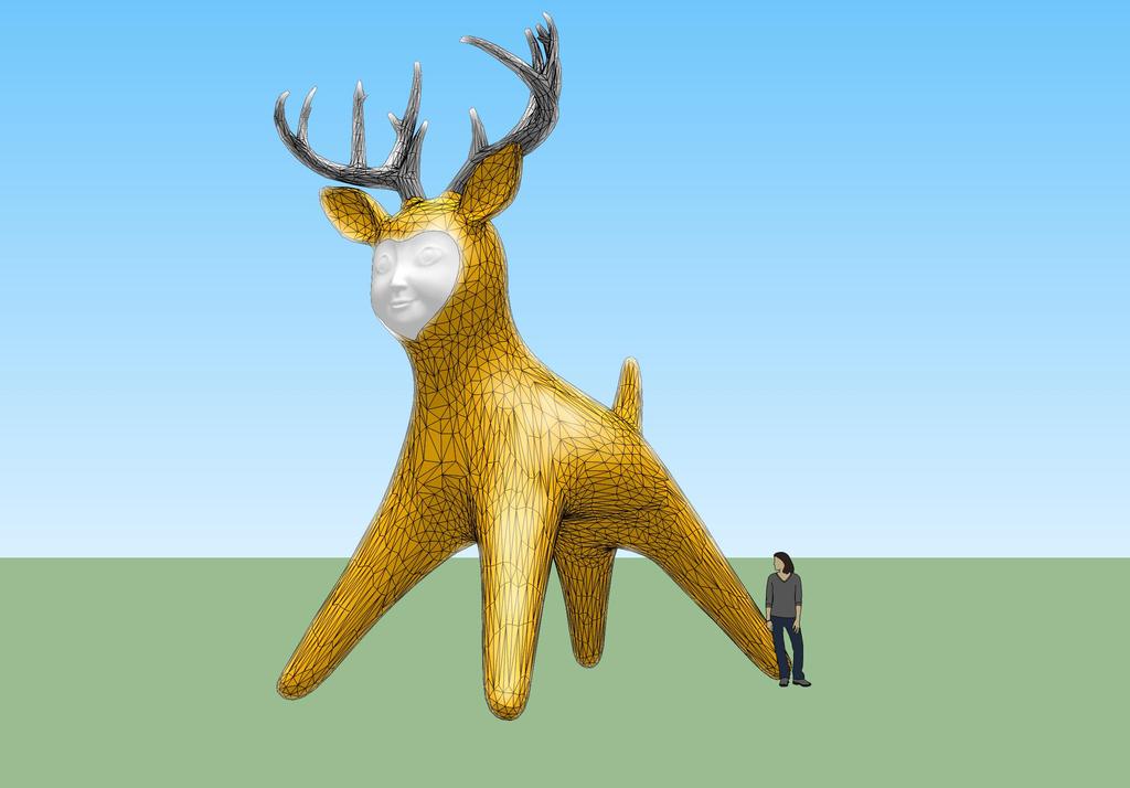
2 Park Ave Station Concept Proposal Artist: Seyed Alavi A large, stylized deer with childlike face speaks to the community s vision of renewal and the proximity of the station to the new Trolley Trail. Drawn from many traditions from NW Coast Native American carvings to colossal roadside sculpture, Rebirth is a monumental icon that creates a link between the natural environment and the commercial strip of McLoughlin Boulevard.
3


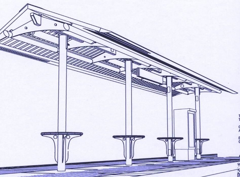
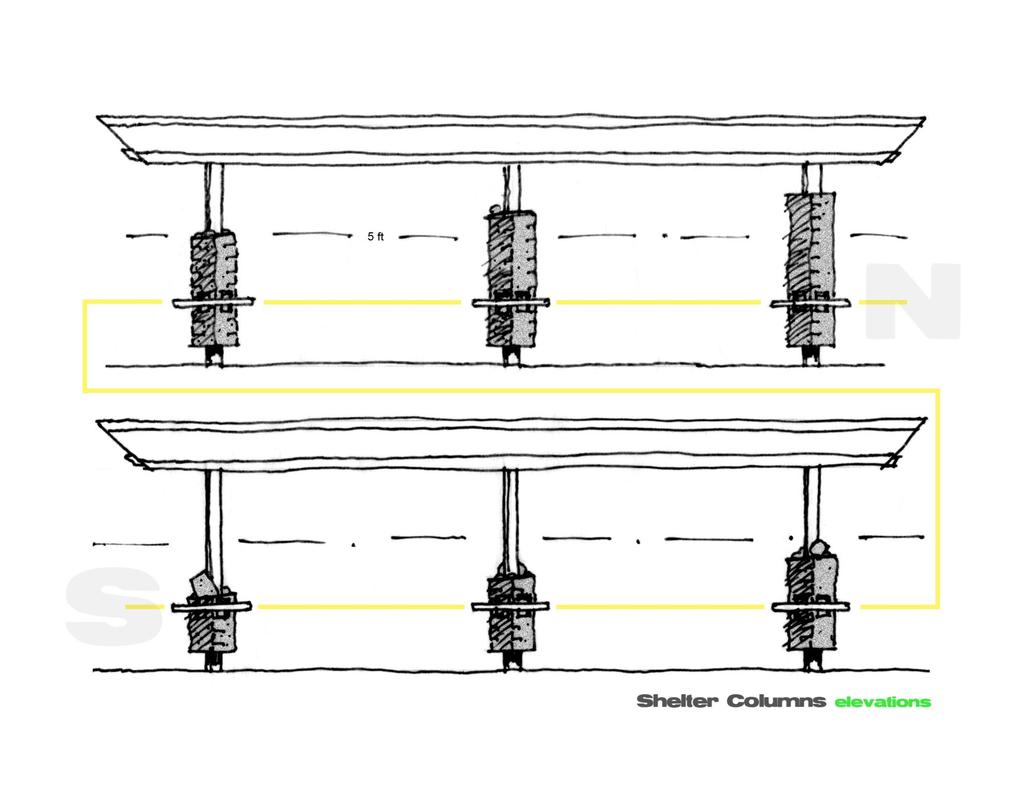
4 Surface Treatment: The Shelter Columns
5 Kellogg Bridge Concept Proposal Artists: Andre Caradec &Thom Faulders Multiple moss green discs cover the underside of select areas of the Kellogg Bridge. The location of the discs and their patterned array respond to the pedestrian and vehicular flow underneath the structure as well as the geometry of the structure itself.
6

7
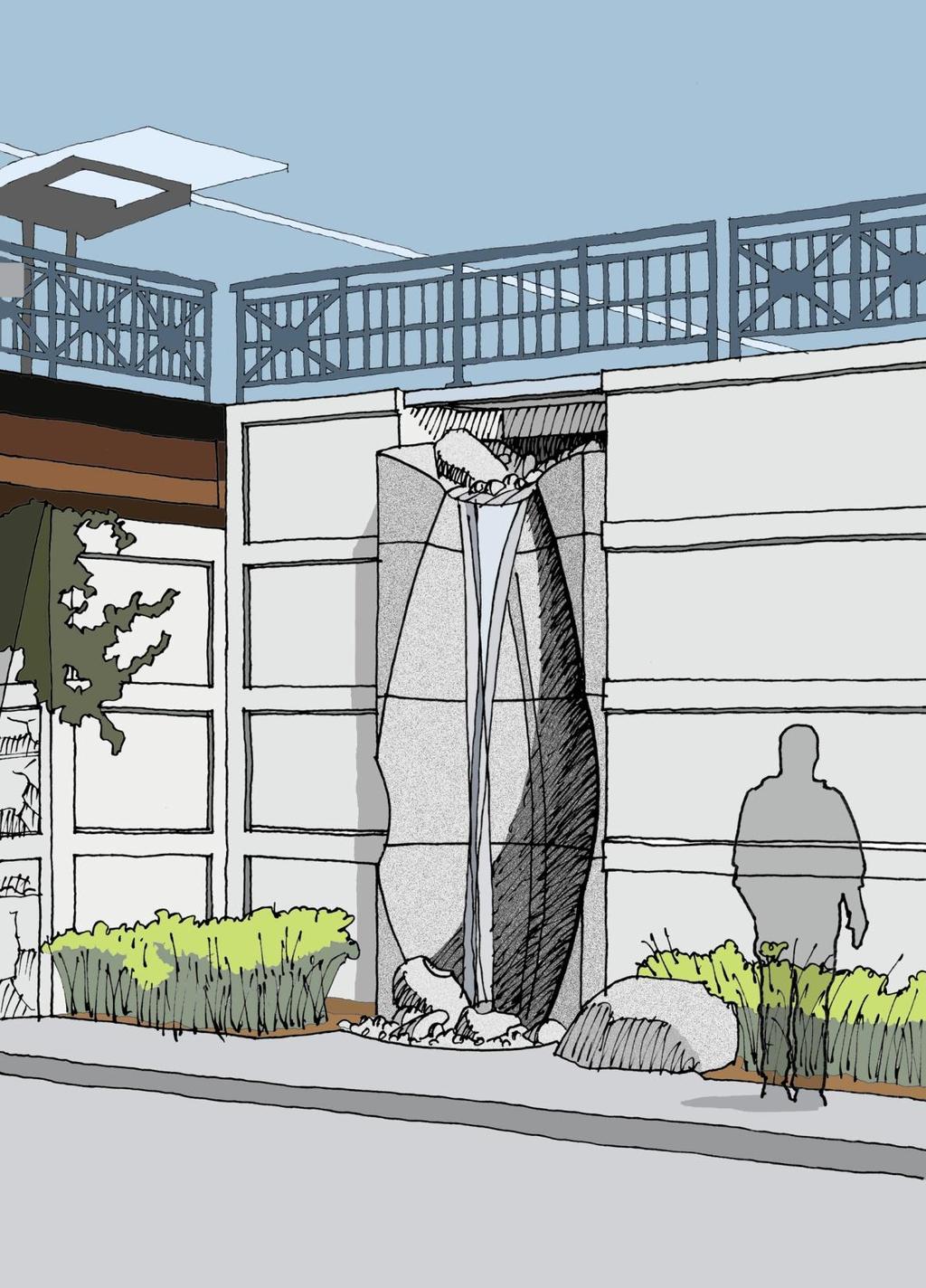
8 Lake Rd Station Concept Proposal Artist: Brian Goldbloom Sculptures mark each of the two entrances to Lake Rd Station and reflect the transitional character of the site. An arched window is carved in granite and suspended high above the ground creating a visible connection to downtown Milwaukie and a gateway to the station platform. To the south, a carved granite streambed routes storm water from the Kellogg Bridge into the landscaped water treatment area on Lake Rd.

9
10
11
12
13 Tacoma St Station Concept Proposal Artist: Thomas Sayre Two large earth-cast wheels serve as landmarks for Tacoma St Station and reference the history of nearby Johnson Creek where a 19 th c. sawmill first turned the wheels of local industry. The process of earth-casting combines the built forms of abstracted gear wheels with the organic quality of the earth.
14

15
16 Bybee Station Concept Proposal Artist: Dana Lynn Louis A rotating lantern with imagery inspired by the beauty of Crystal Springs and the form of 1950 s motion lamps serves as a beacon for the Bybee Blvd Station. Lyrical drawings abstracted from nature appear etched into the elevator and windscreen glass, and may be projected as lighting on other areas of the station.

17
18 17 th Ave Corridor - Rhine and Holgate Stations Concept Proposal Artist: Bill Will Passage is an installation comprised of 40 or more steel rowboats that appear to be floating in the landscape strips along 17 th Avenue from McLoughlin to Powell. The work draws from the natural history of the area, where an old creek lies buried and where wildlife, then people, made their passage to the Willamette River.

19
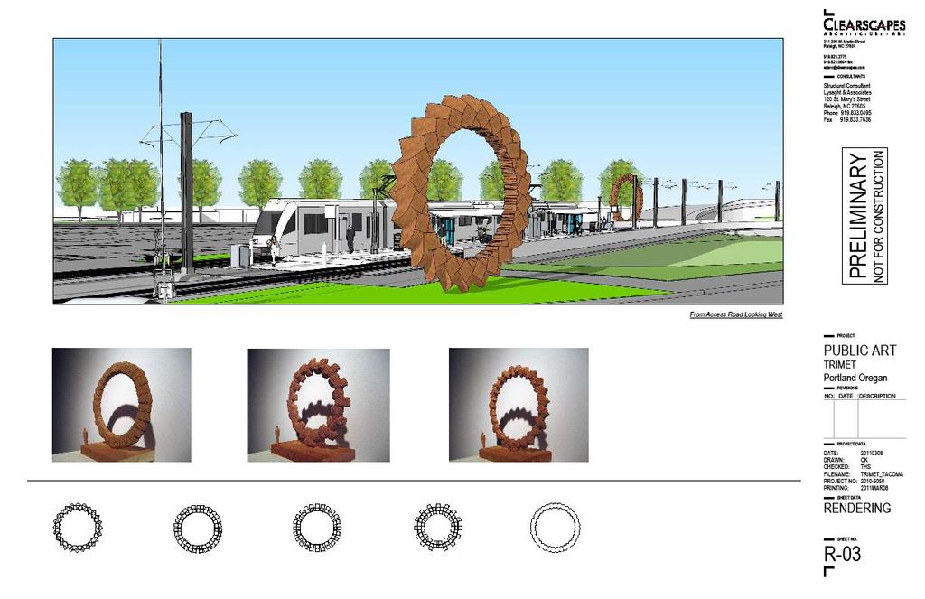
20 Clinton Station Concept Proposal Artist: Rebar/Matthew Passmore A monumental, illuminated steel sculpture marks the entrance to the Clinton St. Station. The Beacon will be constructed of old light rail track bent into curves that recall the vocabulary of transit maps and system trackway. The concept sprang from the history of the neighborhood which has been dramatically shaped by transportation infrastructure from the freight rail system that transects the area, to the defeat of the Mt. Hood Freeway.

21
22
23
24 OMSI/South Waterfront Stations Concept Proposal Artist: Jim Blashfield Four narrow data machines housing video screens are located under the shelters at the bridgehead stations. Slow moving images allude to local history, the river, and nearby cultural institutions and businesses in a poetic, non-narrative form.

25
26 Lincoln St Station Concept Proposal Artist: Elizabeth Conner A series of vertical sculptures that alter in form, color and texture when viewed from different perspectives stand on a berm to the north of the platform. The sculptures were inspired by the theatrical and participatory work of Anna and Lawrence Halprin. Lawrence Halprin s groundbreaking urban design is at the heart of the south auditorium station area.

27
28 Portland-Milwaukie Light Rail Bridge Artist team: Anna Valentina Murch and Doug Hollis Bridge artwork reflects the surrounding environment in a series of experiences that link stations, greenway paths and bridge. Programmable lighting slowly moves across the bridge cables and piers echoing the rhythms of the water and making the bridge appear to breathe. Sound is reflected off curved abutment walls and sections of bike lanes leading off the bridge are scored with grooves that play a song as bicyclists ride over them.

29

30


31
32 System-wide project Artist: Buster Simpson Orange Lining is a concept developed for the construction phase of the PMLR project. Poetic phrases commissioned from local writers will appear on orange fencing used to control erosion. Later, these phrases will be stamped into concrete sidewalks along the new alignment.


33

34
35 Next Steps Artists submit approved concept proposals for Technical Review, which includes TriMet Safety and Security, Operations and Maintenance of Way Staff presents concept proposals to communities and forwards comments to artists Artists synthesize feedback and present their Final Designs to the Public Art Advisory Committee for review and approval (Fall 2011)
36 Public Art Advisory Committee Mark Annen Architect/Artist (Brooklyn) Christine Bourdette Visual artist (South Portland Neighborhood Assoc.) Kristin Calhoun Public Art Manager, Regional Arts and Culture Council Jef Gunn Artist/PNCA Instructor (Brooklyn) Alicia Hamilton Arts Advocate (Milwaukie) Bob Hastings TriMet Agency Architect (South Waterfront) Eleanore Hunter Oak Lodge Community Council Chair (Oak Grove) Matt Menely Small Business Owner, SE Portland (Milwaukie) Gary Michael Architect/Artist (Milwaukie) Cheryl Snow (Chair) Executive Director, Clackamas County Arts Alliance
37 Questions? Contact: Michelle Traver, Public Art Coordinator
Welcome to the Sellwood Bridge Project Pre-Construction Open House
 Welcome to the Sellwood Bridge Project Pre-Construction Open House 5:30 7:30 p.m. Please sign in here Information stations and project staff are located throughout the room. Goals for Tonight s Meeting
A larger version of this map is located on the last page of this PDF.
 MAP Committee Input McLoughlin Area Draft Vision Map A larger version of this map is located on the last page of this PDF. 1. The map above is intended to portray a vision for the McLoughlin area. It highlights
Blue Line LRT Extension
 v e Noble Pkwy Noble Pkwy Xerxes Ave N Shingle Creek Penn Ave N Penn Ave N Fremont Ave N Lyndale Ave N S Washington Ave University Ave NE Blue Line LRT Extension LIGHT RAIL PLATFORM AND STATION DESIGN
Cleveland Innerbelt Bridge / Central Viaduct City Planning Commission November 6, 2009
 Cleveland Innerbelt Bridge / Central Viaduct City Planning Commission November 6, 2009 Process for Aesthetics Subcommittee June 25, 2009 Kick off Meeting June 26, 2009 Gateway and Tremont Focus Groups
Boeckman Road Extension
 Boeckman Road Extension Providing Safe Passage for Wildlife and Maintaining Habitat Connectivity By Kerry Rappold, City of Wilsonville Leslie Bliss-Ketchum, Portland State University October 20, 2008 Presentation
South Waterfront Park
 South Waterfront Park The South Waterfront Greenway Development Plan (GDP) has achieved an integrated and balanced design that fuses the goal of creating a new high-density urban community with the desire
Potential Green Infrastructure Strategies May 6, 2015 Workshop
 Potential Green Infrastructure Strategies May 6, 2015 Workshop Background The City of Cortland is developing the Tioughnioga Urban Headwaters Green Infrastructure Action Plan with funding from the National
Luminous Bodies and the Corridor of Light for Lynn Street Rosslyn
 Luminous Bodies and the Corridor of Light for Lynn Street Rosslyn Artist & landscape architect Cliff Garten, Venice, CA selected Harbor View, Long Beach, CA Avenue of Light, Fort Worth, TX The project
Small Area Plan. South Gateway
 Small Area Plan Adopted May 12, 2008 South Gateway Purpose. The South Gateway Small Area Plan defines the City s expectations for the future of the southern entrance to the City at Interstate 85 and Highway
1 st now. Design Elements. iii STREET TREES PATTERNED CROSSWALKS SPECIAL SIDEWALK PAVING. First Street ELEMENTS TRANSIT SHELTER / LANTERN
 Design Elements A framework for Design Elements has been developed in response to Project Restore s vision and goals for the First Street Corridor. Guided by the principles good urban design and smart
Hopkins. Development Guidelines May Overview. Sponsored by: Blake Road Corridor Collaborative City of Hopkins
 Hopkins Blake Road LRT Station Area Development Guidelines May 2015 Sponsored by: Blake Road Corridor Collaborative City of Hopkins Overview Hopkins is a dynamic community of over 17,000 residents located
V. Gateways GATEWAYS / V-1
 V. GATEWAYS / V-1 Many of Chesapeake s gateways are located on highways and call for bold and attractive designs that motorists can understand, appreciate, and enjoy. can also take the form of natural
People who are members of historically disenfranchised racial, ethnic, cultural, and other identity groups are encouraged to apply.
 CALL TO ARTISTS REQUEST FOR QUALIFICATIONS CITY OF TACOMA MUNICIPAL ART PROGRAM East 64 th Streetscape, Tacoma, WA APPLICATION DEADLINE October 10, 2018, 11:59pm BUDGET $72,000, all-inclusive SUMMARY The
The open space system should provide connective elements, relate to natural resources, and enhance the suburban character of the landscape..
 The open space system should provide connective elements, relate to natural resources, and enhance the suburban character of the landscape.. Mixed-use and infill development should maintain or enhance
APPENDIX A: Willamette River Bridge Survey
 APPENDIX A: Willamette River Bridge Survey The Oregon Department of Transportation is in the final phase of completing the Environmental Assessment which outlines the potential environmental impacts of
Community Engagement Committee Meeting #1 December 10, :30pm-8:30pm
 Community Engagement Committee Meeting #1 December 10, 2014 6:30pm-8:30pm Welcome and Introductions Dana Murdoch Minneapolis Park and Recreation Board Project Manager Ryan French Walker Art Center Director
ROME WATERFRONT VILLAGE PROJECT NARRATIVE January 25, 2018
 January 25, 2018 The Rome Waterfront Village project is intended to foster the revitalization of the area between South James Street and Erie Boulevard north of the Erie Canal as well as improve public
Northwest Rail Corridor and US 36 BRT Development Oriented Transit Analysis 4.4 STATION AREA FINDINGS
 4.4 STATION AREA FINDINGS Each station is different, and each one requires a separate set of recommendations based on the vision for the site. This section outlines an initial TOD strategy and recommendations
Cleveland Innerbelt Bridge / Central Viaduct Cleveland City Planning Commission October 2, 2009
 Cleveland Innerbelt Bridge / Central Viaduct Cleveland City Planning Commission October 2, 2009 New Westbound Bridge Schedule December 1, 2009 Contract Documents/Plan Package March 1, 2010 Request for
PIKE PINE RENAISSANCE: ACT ONE. October 19, 2017
 PIKE PINE RENAISSANCE: ACT ONE October 19, 2017 WATERFRONT SEATTLE PROGRAM PROJECT INTRODUCTION Pike and Pine streets, between First and Melrose avenues Pedestrian and streetscape improvements Budget:
VEHICULAR AND PEDESTRIAN CIRCULATION
 This perspective sketch communicates the intended character and quality of a proposed streetscape design. Locate benches near a major intersection where people tend to gather. Seating and lighting provide
Community Open House March 26 th, 2018
 Community Open House March 26 th, 2018 Open House Agenda 1. Overview of Planning Process What we heard 2. Future Land Use Policy 3. Priority Growth Areas 4. Plan Elements Making it happen What is a Comprehensive
Goals AND Guiding principles
 Historic photo of Eastlake Train Station sign Chapter 2: Goals AND Guiding principles 2-1 The Plan goals includes a desire to bridge present day conditions with a vision of the area s future. A central
Estacada s Broadway Street Improvements Public Art & Amenities Guide. Honoring our past, welcoming our future.
 Estacada s Broadway Street Improvements Honoring our past, welcoming our future. INTRODUCTION Estacada s arts and culture scene is an economic development asset and an outlet for local creativity. Quality
METRO Gold Line BRT CBAC Meeting. August 23, 2018
 METRO Gold Line BRT CBAC Meeting August 23, 2018 1 Today s Topics Introductions Corridor Management Committee Update Public Engagement Update History of Alignment Project Scope Discussions Upcoming CBAC
Tyvola & Archdale Transit Station Area Plan. May 15, 2008
 Tyvola & Archdale Transit Station Area Plan First Public Meeting May 15, 2008 Presentation Outline 1. Purpose and Process 2. Station Area Overview 3. Plan Recommendations Vision Land Use Transportation
Transportation Committee
 Transportation Committee Business Item No. 2013-286SW Meeting date: October 14, 2013 For the Metropolitan Council meeting of October 16, 2013 Subject: Southwest Light Rail Transit (Green Line Extension):
Workshop #3 June 13, 2016
 Downtown Ocoee Master Plan Workshop #3 June 13, 2016 Our Team Our Team and Tonight s Goal Quick Recap: Why a Downtown Plan? How are we developing the plan? How can you still be involved? What s left to
Kenilworth Station Art and Landscape Committee (KSALC) June 25, 2015
 June 25, 2015") Kenilworth Station Art and Landscape Committee (KSALC) June 25, 2015 1 Today s Topics Welcome and Introductions Appoint Committee Co-Chairs Summary of Community Workshop #1 Kenilworth Channel Bridge Design
Kenilworth Station Art and Landscape Committee (KSALC) June 25, 2015 1 Today s Topics Welcome and Introductions Appoint Committee Co-Chairs Summary of Community Workshop #1 Kenilworth Channel Bridge Design
Community Sensitive Design: (Context Sensitive Design)
") What is? Community Sensitive Design: (Context Sensitive Design) The process by which urban design, land-use planning and aesthetic enhancements are applied to a project to make it an integral part of the
What is? Community Sensitive Design: (Context Sensitive Design) The process by which urban design, land-use planning and aesthetic enhancements are applied to a project to make it an integral part of the
East Midtown Greenway East 53 rd 61 st Street. Community Board 8 Project Introduction November 16, 2017
 East Midtown Greenway East 53 rd 61 st Street Community Board 8 Project Introduction November 16, 2017 Agenda Overview - Development of the East Midtown Waterfront Esplanade Current East Midtown Greenway
July 12, Columbus City Council City Hall 90 West Broad Street Columbus, OH RE: I-70/71 Columbus Crossroads Project
 OHIO DEPARTMENT OF TRANSPORTATION DISTRICT 6 400 EAST WILLIAM STREET DELAWARE, OHIO 43015 800.372.7714 Columbus City Council City Hall 90 West Broad Street Columbus, OH 43215-9015 RE: I-70/71 Columbus
ATTACHMENT A Update 04/01/19 Department of Transportation & Development Long-Range Planning Work Program - Input Received from Outreach
 ATTACHMENT A Update 04/01/19 Department of Transportation & Development 019-00 Long-Range Planning Work Program - Input Received from Outreach The table below is organized by chapter with related projects
124 Subarea Visions. Vision Plan. A. Nelessen Associates, INC I Visioning I Planning I Urban Design
 Subareas 124 Subarea Visions The next seven sections describe specific recommendations tailored to each subarea. Each subarea is discussed separately except for certain aspects of 95th Street and Antioch
North Macadam Transportation Development Strategy Summary of Past Studies DRAFT
 North Macadam Transportation Development Strategy Summary of Past Studies DRAFT Several previous studies were reviewed to gain an understanding and document the recent transportation issues in the North
Maplewood Avenue Downtown Complete Street Project
 Maplewood Avenue Downtown Complete Street Project Second Public Meeting January 24, 2018 Welcome and Introduction of Project Team City Planning and Public Works Staff City of Portsmouth Juliet Walker Planning
RZC Public View Corridors and Gateways
 RZC 21.42 Public View Corridors and Gateways 21.42.010 Purpose 21.42.020 Scope and Authority 21.42.030 Administration 21.42.040 Gateways Design 21.42.050 Unidentified Public Views 21.42.060 Identification
CALL TO ARTISTS REQUEST FOR QUALIFICATIONS STart PUBLIC ART PROGRAM
 CALL TO ARTISTS REQUEST FOR QUALIFICATIONS STart PUBLIC ART PROGRAM DOWNTOWN TACOMA GATEWAY ARTWORK Sound Transit s Public Art Program (STart) is seeking an artist or artist team to create a site-responsive
Lake Oswego to Portland Transit Project. Lessons Learned. John Cullerton Senior Project Manager, URS 2012 APTA/TRB Light Rail Conference
 Lake Oswego to Portland Transit Project Lessons Learned John Cullerton Senior Project Manager, URS 2012 APTA/TRB Light Rail Conference Overview Project Location and Context Corridor History and Project
TOWN BRANCH COMMONS & VINE STREET MOBILITY IMPROVEMENTS
 TOWN BRANCH COMMONS & VINE STREET MOBILITY IMPROVEMENTS CONTACT: Jeff Fugate, President O: 859-367-4972 F: 859-425-2292 JFugate@LexingtonDDA.com www.lexingtondda.com TOWN BRANCH COMMONS & VINE STREET MOBILITY
Option A FINAL AESTHETIC SIGNATURE BRIDGE PROPOSAL. SR 836/I-395/I-95 Project
 ELECTRONIC COPY AESTHETIC VOLUME 2 2.28.17 APPROVED SIGNATURE BRIDGE PACKAGE, APTES, AND SIGNATURE BRIDGE RELATED ATCS SR 836/I-395/I-95 Project Florida Department of Transportation District 6 & Miami-Dade
5. Father Hennepin Blufs Park and Hennepin Island Father Hennepin Bluffs Park Supporting Initiatives (see Figure 36): 7-22
: 7-22") 5. Father Hennepin Blufs Park and Hennepin Island As described in existing conditions portion of Chapter 2, Father Hennepin Blufs Park lies on the upland portion of the park and Hennepin Island spans the
5. Father Hennepin Blufs Park and Hennepin Island As described in existing conditions portion of Chapter 2, Father Hennepin Blufs Park lies on the upland portion of the park and Hennepin Island spans the
LAKEVIEW LOCAL ADVISORY PANEL. THE COPORATION OF THE CITY OF MISSISSAUGA THURSDAY, NOVEMBER 18, 2010
 LAKEVIEW LOCAL ADVISORY PANEL THE COPORATION OF THE CITY OF MISSISSAUGA www.mississauga.ca/lakeviewportcreditreview THURSDAY, NOVEMBER 18, 2010 MISSISSAUGA SENIORS CENTRE LUCY TURNBALL ROOM (1389 Cawthra
COMMUNICATION URBAN DESIGN REVIEW BOARD CITY OF DES MOINES, IOWA MAY 16, 2017 MEETING
 COMMUNICATION URBAN DESIGN REVIEW BOARD CITY OF DES MOINES, IOWA MAY 16, 2017 MEETING Subject: Recommendation Prepared by: PRELIMINARY DESIGN REVIEW OF LOCUST STREET BRIDGE CONSTRUCTION & COURT AVENUE,
Town Center. Block 5 Existing multifamily residential units are expected to remain.
 Area Guidelines Germantown s districts should be developed as distinct communities with unique features that are supported through the guidelines. The guidelines not only help distinguish these districts
Lower South Street/Louisa Street Charrette Final Presentation. September 22, 2009
 Lower South Street/Louisa Street Charrette Final Presentation September 22, 2009 Recap Mayor and Council called for a Charrette to engage the public on creating a vision for the Lower South Street area.
APPENDIX D: Visual and Aesthetic Conditions for NCCU Station Refinement. Durham-Orange Light Rail Transit Project
 APPENDIX D: Visual and Aesthetic Conditions for NCCU Station Refinement Durham-Orange Light Rail Transit Project October 2016 1. Introduction The Combined FEIS/ROD summarizes the effects of the D-O LRT
I-70 Corridor Enhancement Plan
 i - Table of Contents Table of Contents Chapter I Overview Chapter II Bridge and Roadway Improvements Chapter III Landscape Enhancements Chapter IV Riparian Corridors Chapter V Showcase Missouri Plan Chapter
Project Profile BAR HARBOR
 1 BAR HARBOR The Bar Harbor Master Plan merges community vision with design guidelines to preserve the unique character of Bar Harbor Village. PROJECT SUMMARY Overview: The economic vitality of Bar Harbor
Atlanta BeltLine. Subareas 9 & 10. Master Plan Updates. March 26, Washington Park Jamboree 1
 Atlanta BeltLine Subareas 9 & 10 Master Plan Updates March 26, 2018 Washington Park Jamboree 1 22 miles, connecting 45 neighborhoods 22 MILES of transit 46 MILES of streetscapes and complete streets 33
Section4 Design Vision & Implementation Plan
 Section4 Design Vision & Implementation Plan W Woodschurch Rd 4.1 Design Focus Areas The Framework Plan is simply the starting point for directing the design and implementation of a wide range of transportation
Bloor Street East Potential Ravine Portal Overlook and Access Passage to the Rosedale Valley and Don River Valley Ravine, Toronto, Canada
 TRANSFORMATIVE IDEA 2. GREAT STREETS Bloor Street Christie Pits Park Bloor St Spadina Ave Bathurst St Shaw St 1 Recognize the significant public realm improvements along Bloor Street and extend and enhance
The Lower SaLuda Greenway
 The Lower SaLuda Greenway InITIaTIve a FLourIShInG Greenway. a hub For economic GrowTh. a ConneCTIon BeTween CoMMunITIeS. In April 2017 the Michael J. Mungo Foundation and Lexington County commissioned
Good Design Guidelines for Downtown. Preliminary Findings and Recommendations
 Good Design Guidelines for Downtown Preliminary Findings and Recommendations City Council Meeting - February 5, 2017 Advisory Committee Team: Larry Paul: Planning Commission /Architect Bruce Bagnoli: Business
New York Avenue Streetscape and Trail Project Public Meeting #1 Summary
 New York Avenue Streetscape and Trail Project Public Meeting #1 Summary I. King Jordan Student Academic Center (SAC) Gallaudet University, Washington, DC February 23, 2017 Table of Contents 1.0 Introduction...
Alternative Refinement Update. Policy Advisory Group December 10, 2007
 Alternative Refinement Update Policy Advisory Group December 10, 2007 Alternative A Alternative B Alternative C Alternative D Alternative E Draft EIS Alternatives Bridge Type Selection Policy Advisory
Century Park to Ellerslie Road Preliminary Engineering
 Century Park to Ellerslie Road Preliminary Engineering South LRT Extension Stakeholder Information Panel Brochure March 2010 www.edmonton.ca/lrtprojects LRT Station (left) and Transit Centre Architectural
LAND USE AMENDMENT DOWNTOWN COMMERCIAL CORE (WARD 7) MACLEOD TRAIL SE AND 5 AVENUE SE BYLAW 254D2017
 MACLEOD TRAIL SE AND 5 AVENUE SE BYLAW 254D2017") Page 1 of 10 EXECUTIVE SUMMARY This Land Use Amendment application seeks to redesignate a full downtown block (currently the YWCA site) from a Direct Control based on the CM-2 District (Land Use Bylaw
Page 1 of 10 EXECUTIVE SUMMARY This Land Use Amendment application seeks to redesignate a full downtown block (currently the YWCA site) from a Direct Control based on the CM-2 District (Land Use Bylaw
Glenborough at Easton Land Use Master Plan
 Vision Statement Sunrise Blvd. Hazel Ave. Prairie City Rd. Gencorp Property Lincoln Regional Airport 1.0 VISION STATEMENT The identifies City of the principles, goals, policies, and standards Lincoln that
EcoVerde MADISON TO DOWNTOWN TO BEACH. Legend Highway Major Connection Major Street Local Street Proposed Access. Response to Tropicana Field RFP
 EcoVerde TO BEACH 275 16th Street North 16th Street South 13th Street North 13th Street South 11th Street North 11th Street South 1st Avenue North Central Avenue 1st Avenue South TO DOWNTOWN 2nd Avenue
CHAPTER 1. Ms. Guajardo s Class - Central Elementary CH 1 1
 INTRODUCTION CHAPTER 1 Ms. Guajardo s Class - Central Elementary CH 1 1 1.1 SETTING South Centre City is a linear corridor south of Downtown Escondido paralleling Centre City Parkway and South Escondido
WELCOME TO THE CHOUTEAU GREENWAY DESIGN, DEVELOPMENT AND CONSTRUCTION WORKING GROUP!
 WELCOME TO THE CHOUTEAU GREENWAY DESIGN, DEVELOPMENT AND CONSTRUCTION WORKING GROUP! Chouteau Greenway Steering Committee and Working Groups Overview Overview January 9, 2019 Chouteau Greenway will transform
Expo Light Rail Line. Expo Line Community Meeting Phase 2 Design Update November 2011
 Expo Line Community Meeting Phase 2 Design Update November 2011 Meeting Agenda Phase 2 Design Update Meeting Meeting Purpose and Format Project Status Update Overview of Design Progress Next Steps Open
REVIEW AND APPROVAL OF FINAL ART PLAN FOR THE SIERRA MADRE VILLA CORRIDOR PUBLIC ART PROJECT
 TO: FROM: SUBJECT: Honorable Mayor and City Council Planning & Community Development Department REVIEW AND APPROVAL OF FINAL ART PLAN FOR THE SIERRA MADRE VILLA CORRIDOR PUBLIC ART PROJECT RECOMMENDATION:
OMSI - Clinton: A Corridor for Invention and Innovation
 OMSI - Clinton: A Corridor for Invention and Innovation June 14, 2013 TABLE OF CONTENTS Page 1- Context and Opportunity Page 2- Existing Conditions Page 3- Design Principles Page 4- Recommendations Page
ADMINISTRATION RECOMMENDATION(S) 2018 January 25. That Calgary Planning Commission recommend APPROVAL of the proposed Land Use Amendment.
 2018 January 25. That Calgary Planning Commission recommend APPROVAL of the proposed Land Use Amendment.") Page 1 of 9 EXECUTIVE SUMMARY This land use amendment proposes to redesignate a parcel from DC Direct Control District to Multi-Residential Contextual Grade-Oriented (M-CG) District to allow for multi-residential
Page 1 of 9 EXECUTIVE SUMMARY This land use amendment proposes to redesignate a parcel from DC Direct Control District to Multi-Residential Contextual Grade-Oriented (M-CG) District to allow for multi-residential
Public may provide comments on the GDP within the next two weeks (December 24)
") 25/70 General Development Plan (GDP) Public Meeting Wednesday, December 10, 2014 6:00 8:00 P.M. District 1 Police Station Community Room 1311 W 46th Ave, Denver, CO 80211 Council Woman Montero: This particular
25/70 General Development Plan (GDP) Public Meeting Wednesday, December 10, 2014 6:00 8:00 P.M. District 1 Police Station Community Room 1311 W 46th Ave, Denver, CO 80211 Council Woman Montero: This particular
MEMORANDUM. This memo deals with proposed amendments to previously issued Development Permit No for Park Royal North.
 MEMORANDUM Date: August 28, 2015 Our File: 1010-20-15-062 To: Design Review Committee From: Lisa Berg, Senior Community Planner Re: Amendment to Development Permit for Park Royal North This memo deals
STRIP PORTALS. Concept Plan. December 2008 page 1. PFAFFMANN + ASSOCIATES 223 Fourth Avenue Pittsburgh, PA
 Concept Plan PFAFFMANN + ASSOCIATES 223 Fourth Avenue Pittsburgh, PA 15222 412.471.2470 December 2008 page 1 Concept Plan Project Summary Project Team Neighbors in the Strip 1212 Smallman Street Pittsburgh,
Workshop 3. City of Burlington Waterfront Hotel Planning Study. September 14, The Planning Partnership
 Workshop 3 City of Burlington Waterfront Hotel Planning Study September 14, 2017 The Planning Partnership The Waterfront Hotel Planning Study 01 The Brant & Lakeshore Planning Study will establish a Strategic
Derby-Shelton Bridge Pedestrian and Bicyclist Enhancements [1]
![Derby-Shelton Bridge Pedestrian and Bicyclist Enhancements [1]](/thumbs/96/128011958.jpg "Derby-Shelton Bridge Pedestrian and Bicyclist Enhancements [1]") nhancements [1] STATUS OF PROJECT: The project has recently moved from the Preliminary Design Phase to the Final Design Phase following the most recent Public Involvement Meeting held on January 9, 2019
nhancements [1] STATUS OF PROJECT: The project has recently moved from the Preliminary Design Phase to the Final Design Phase following the most recent Public Involvement Meeting held on January 9, 2019
WEST LOOP DESIGN GUIDELINES CHECKLIST
 WEST LOOP DESIGN GUIDELINES CHECKLIST Section 1.0 General Strategies 1.1 DESIGN EXCELLENCE: ENCOURAGE HIGH QUALITY AND INNOVATIVE DESIGN OF NEW BUILDINGS WITHIN THE WEST LOOP WITHOUT BEING PRESCRIPTIVE
I-70/71 Innerbelt Project
 I-70/71 Innerbelt Project Project Progress Meeting and Design Enhancement Update November 9, 2009 Ohio Department of Transportation MS Consultants MSI Design Overview of Presentation 1. Recap Recent Project
Figure Example of out door dining in the public right-of-way.
 Section 2 Core Area Goal 2.2.1 To maintain and enhance the character of existing streets in the Downtown Area. Character Figure 2.2.1 Example of out door dining in the public right-of-way. A. Provide street
Tyvola & Archdale Transit Station Area Plan. June 5, 2008
 Tyvola & Archdale Transit Station Area Plan Second Public Meeting June 5, 2008 Presentation Outline 1. Purpose and Process 2. Station Area Overview 3. Plan Recommendations 4. Comments Received and Proposed
INNERBELT BRIDGE PUBLIC MEETING #2
 Welcome to the INNERBELT BRIDGE PUBLIC MEETING #2 Today s Discussion Welcome and Introductions (Bob Brown, City of Cleveland) Innerbelt Project Status (Craig Hebebrand, ODOT) Bridge Type Selection Update
CHARLOTTESVILLE. Streetscape ENTRANCE CORRIDOR DESIGN GUIDELINES. Amendments adopted by City Council March 7, Design Principles...
 CHARLOTTESVILLE ENTRANCE CORRIDOR DESIGN GUIDELINES Amendments adopted by City Council March 7, 2011 2 Streetscape A. B. C. D. E. F. G. H. I. Design Principles...5 Plantings & Open Space...6 Pedestrian
WELCOME! MINNEHAHA-HIAWATHA Community Works Project. 46th Street Area Lighting Project July 2009
 WELCOME! MINNEHAHA-HIAWATHA Community Works Project 46th Street Area Lighting Project July 2009 Partners The 46th Street Lighting project is a collaboration between Hennepin County and: The City of Minneapolis
Route 347. New York State Department of Transportation Region 10, Long Island. THE GREENING of ROUTE 347
 The GREENING of Route 347 The Greening of Route 347 The Greening of Route 347: History 3 The Greening of Route 347 4 The Greening of Route 347 5 The Greening of Route 347 Smith Haven Mall 6 The Greening
ITEM #8. Regional Smart Growth Program. Regional Smart Growth Program. Presentation Overview. Coast Highway Vision and Stategic Plan.
 Regional Smart Growth Program Economic Development Commission What is Smart Growth? Adopted as part of the Regional Comprehensive Plan (RCP) RCP provides vision for region based on Smart Growth and sustainability
BRADENTON RIVERWALK EXPANSION MASTER PLAN
 BRADENTON RIVERWALK EXPANSION MASTER PLAN INTRODUCTION & AGENDA Process Update Community Engagement Summary Center for Active Design (CfAD) Recommendations Context and Existing Conditions Master Plan Alternatives
MURRAY CENTRAL STATION MASTER PLAN Central Station Area of Influence and Site Analysis
 CENTRAL STATION MASTER PLAN Central Station Area of Influence and Site Analysis OVERVIEW Planned Fire Station TAYLORSVILLE A thorough Site Analysis was conducted to ensure planning and design concepts
Trail Feasibility and Planning Project for Northern Dutchess County, New York
 for Northern Dutchess County, New York Funded in Part by Grants from the Hudson River Valley Greenway, Land Trust Alliance Conservation Partnership Program and the Thomas Thompson Trust 1 STEERING COMMITTEE
OVERMOUNTAIN VICTORY TRAIL BURKE CALDELL CORRIDOR FEASIBLITY STUDY REQUEST FOR QUALIFICATIONS CALDWELL COUNTY PATHWAYS
 OVERMOUNTAIN VICTORY TRAIL BURKE CALDELL CORRIDOR FEASIBLITY STUDY REQUEST FOR QUALIFICATIONS CALDWELL COUNTY PATHWAYS Caldwell County Pathways along with our co-partners City of Lenoir, Town of Gamewell,
THEMES, VISION, + PRINCIPLES
 CHAPTER 2: THEMES, VISION, + PRINCIPLES This page intentionally left blank. 20 VISION DRAFT AUGUST 2018 2 2 THEMES, VISION, + GUIDING PRINCIPLES The Key Themes, Vision, and Guiding Principles presented
A Vibrant Downtown. Chapter 5 Cary Public Art Opportunities 31
 A Vibrant Downtown Cary s vision for Downtown is a unique, vibrant, dynamic, pedestrian friendly location; a regional destination and a place to live, work, and recreate, according to the 2001 Town Center
6.3 Elyria-Swansea. Basin Snapshot
 6.3 Elyria-Swansea The Elyria-Swansea Map Unit is comprised of the I-70 & Colorado Blvd basin (0060-01) and the I-70 & York basin (0060-02) from the Denver Storm Drainage Master Plan (SDMP) and has a total
Railroad Safety Trail. Recompiled August Project Description. Prepared For: City of San Luis Obispo
 Adopted June 2001 Recompiled August 2008 Project Description Prepared For: City of San Luis Obispo Prepared By: RRM Design Group 3701 S. Higuera Street San Luis Obispo, California (805) 543-1794 In Association
 Health Sciences City The available land area, although limited, combined with the unique partnership between the primary institutions and the supporting partnerships of the development interests within
What Pioneer Grove Will Look Like?
 The City of Deerfield Beach has embarked on a journey to create a new town center within the old heart of Deerfield Beach. The new town center is known as Pioneer Grove. Pioneer Grove will be Everybody
ALTERNATIVE STATION AREA -
 ALTERNATIVE STATION AREA - THE 10 TH STREET GARDEN STATION Two alternative land use scenarios and designs are illustrated here: Scheme A - Transit-Oriented Development High to Mid-Density Residential /Office
S.R.7/U.S.441 COLLABORATIVE THE COLLEGE OF CORRIDOR KNOWLEDGE
 S.R.7/U.S.441 COLLABORATIVE THE COLLEGE OF CORRIDOR KNOWLEDGE S.R.7 Corridor : A Sense of Place? ANYWHERE USA SR 7: Civilizing the Corridor Bad rules = Bad development! The SR 7 Collaborative A model for
CLACKAMAS COUNTY BOARD OF COUNTY COMMISSIONERS Policy Session Worksheet
 CLACKAMAS COUNTY BOARD OF COUNTY COMMISSIONERS Policy Session Worksheet Presentation Date: March 12, 2019 Approx Start Time: 10:0 AM Approx Length: 1 hour Presentation Title: 2019-20 Long-Range Planning
PLANNING COMMISSION Work Session Meeting Agenda
 PLANNING COMMISSION Work Session Meeting Agenda 5200 85TH AVENUE NORTH BROOKLYN PARK MN 55443 PHONE (763) 424-8000 FAX (763) 493-8391 Wednesday, September 27, 2017-7:00 P.M. Brooklyn Township Room If due
Thank you for coming to the Rail Corridor Land Use Study Public Meeting.
 01 Welcome! Thank you for coming to the Rail Corridor Land Use Study Public Meeting. Tonight is an opportunity to learn about the Land Use Study for the Rail Corridor Site. In Fall 2016, Toronto City Council
Sherman Oaks - Studio City - Toluca Lake - Cahuenga Pass Non-Parcel Resources 02/26/13
 Non-Parcel Resources Adina Dr between Oakshire and Ellington Adina-Passmore Public Stairway Year built: 1930 Context: Residential Development and Suburbanization, 1850-1980 Theme: Automobile Suburbanization,
RESOLUTION APPROVING THE DESIGN CONCEPT FOR THE JEPSON PARKWAY GATEWAY ENHANCEMENT PROJECT {FEDERAL PROJECT NO. RPSTPLE-5094(050)}
}") Agenda Item No.9A October 12, 2010 TO: FROM: SUBJECT: Honorable Mayor and City Council Attention: Laura C. Kuhn, City Manager Rod Moresco, Director of Public Works/City Engineer RESOLUTION APPROVING THE
Agenda Item No.9A October 12, 2010 TO: FROM: SUBJECT: Honorable Mayor and City Council Attention: Laura C. Kuhn, City Manager Rod Moresco, Director of Public Works/City Engineer RESOLUTION APPROVING THE
Stakeholders Advisory Working Groups (SAWGs) Smart Growth and TOD Land Use (#11) SAWG Meeting
 Smart Growth and TOD Land Use (#11) SAWG Meeting") Presentation - Part II Tappan Zee Bridge/I-287 Corridor Project July 21, 2010 Slide 1. David Kooris (Regional Plan Association) welcomed members of the Land Use Stakeholders Advisory Working Groups (SAWGs)
Presentation - Part II Tappan Zee Bridge/I-287 Corridor Project July 21, 2010 Slide 1. David Kooris (Regional Plan Association) welcomed members of the Land Use Stakeholders Advisory Working Groups (SAWGs)
YOUR FUTURE RIDE. Lynnwood. 200th St SW. Lynnwood. Transit Center. 52nd Ave W. 220th St SW. Transit Center. 236th St SW. 244th St SW.
 .17 YOUR FUTURE RIDE Lynnwood Lynnwood Transit Center 200th St SW P 44th Ave W 220th St SW Includes accommodations for a future station 2nd Ave W Mountlake Terrace Edmonds Lake Ballinger Mountlake Terrace
Keyport. Vision for Keyport
 Keyport Vision for Keyport Keyport is a rural, historic waterfront village bounded and limited in size by its natural borders of water and the Naval Undersea Warfare Center. The community consists primarily