2007 Blaine Wharf District Master Plan ii
|
|
|
- Derick Watts
- 6 years ago
- Views:
Transcription
1
2 INTRODUCTION... 1 BLAINE SETTING... 1 GENERAL LOCATION... 2 WHARF DISTRICT... 2 SITE HISTORY... 5 PLANNING AND ANALYSIS PROCESS... 5 BLAINE WHARF DISTRICT MASTER PLAN... 7 CITY OF BLAINE VISION STATEMENT WHARF DISTRICT PLAN PURPOSE... 8 WHARF DISTRICT PLAN GOALS... 8 PUBLIC ACCESS & CIRCULATION OVERLAY ELEMENT... 9 PLANNING AREAS Planning Area 1 Gateway to Waterfront (Visual & Physical Access) Planning Area 2 Plover Park (Recreation & Boat Launch) Planning Area 3: Mariner Village (Mixed Use) Planning Area 4: Harbor Gateway (Marina Support) Planning Area 5: Waters Edge (Public Access) Planning Area 5A: Marine Park Planning Area 5B: Festival Square/Public Parking Planning Area 5C: Lighthouse Park Planning Area 5d: The Wharf Planning Area 6: Shipyard Industrial Park (Industrial) Planning Area 7: Dakota Commons (Commercial) APPENDIX EXISTING FACILITY DESCRIPTIONS IMPLEMENTATION PLAN REGULATORY ENVIRONMENT ii
3 Introduction The Blaine Wharf District Master Plan is the City s and Port s coordinated strategy for the future of the waterfront. It establishes public policy and development standards for all new public and private development in the Wharf District that will create a lively mixed use district for living, working, and playing. This Plan, in conjunction with development regulations set forth in the City of Blaine s Land Use Regulatory Code, will guide development in the Wharf District as it becomes a gateway to and from downtown. It envisions a mixed use district attuned to the intrinsic qualities of its water setting that compliments the Central Business (CB)-Market District. The Wharf District Master Plan focuses on individual policies, projects and regulations to realize the Wharf District s potential as an attractive setting for maritime industry, civic redevelopment, and water-oriented recreation. Taken together, the total impact of these efforts will be much more than the sum of the individual actions themselves. They will create a waterfront that: Is an active, diversified destination attraction and focus for the City. Features a variety of integrated recreational, commercial, marine, industrial, and residential activities. Is well connected with other districts in downtown Blaine. Is easily accessible by pedestrians, boaters, vehicles, bicycles, and visitors. Offers a wide variety of physical settings, landscaped parks, and pedestrian attractions that are connected by a continuous two mile loop of trails, walkways and promenades along the waterfront s edge. Is based on environmentally sound shoreline management with improved water quality and more ecologically productive shoreline. Blaine Setting Blaine is surrounded by some of the region s premier vistas. Mt. Baker and the north Cascade mountain range create a striking visual backdrop to the east, while to the west Semiahmoo Bay and the Straight of Georgia offer a picturesque marine panorama. Blaine s natural setting is an impressive and valuable asset to the community. Blaine's estimated population is approximately 4,700 (2007). The city s principal economic activities are retail, trade, fishing and fish processing, tourism, and government employment. The Resort at Semiahmoo, just across the Drayton Harbor waterway, is a premier-quality, four-star destination resort. 1

4 General Location Blaine is located in the northwest corner of the county contiguous with the border of Canada a little more than a half-hour s drive south of Vancouver, B.C. and a two hours drive north of Seattle. Blaine is known primarily as the port of entry between Canada and the United States. Located on Interstate 5, it is the busiest border crossing between Washington State and British Columbia (an average of 68,000 people pass through the city daily). Peace Arch Park, located in Blaine, is an international facility commemorating the peace and friendship of the peoples of the United States and Canada. Wharf District The Blaine Wharf District contains approximately 2 miles of continuous shoreline off Semiahmoo Bay and Drayton Harbor and is adjacent to the City of Blaine s downtown core and Central Business- Market District. The Burlington Northern Railroad right-of-way separates the upland downtown area from the harbor area. The Wharf District is bounded on the east by the BNSF main line railroad tracks, and wraps around the Blaine Harbor Marina s breakwater on the south to Fisherman s Pier on the northwest, and continues around to a northeast point of land near Marine Drive back at the railroad tracks. Marine Drive is the main arterial to the Wharf District and separates Port property to the south, and the City-owned property to the north of Marine Drive. Figure 1: General Vicinity Map 2

5 Figure 2: City of Blaine Central Business District Zoning 3

6 Figure 3: City of Blaine Zoning Map 4
, currently known as Marine Drive.")

7 Site History Originally the Blaine marina site was tide flats with shallow water depths similar to the Blaine Harbor area that currently surrounds the marina. In the mid- 1880s, a wharf was built along E Street (Milhollin Wharf), currently known as Marine Drive. By 1909, Blaine s waterfront was home to a number of businesses, including five canneries, three lumber mills, an oyster industry, a crab cannery, and three shingle mills. All of the original mills and canneries have since closed, with the last cannery shutting its doors in the mid-1960s. The only remaining structures from those original industries are some buildings from the Alaska Packers cannery which have been incorporated into the Resort at Semiahmoo building complex. Figure 4: Old Milhollin Wharf The Port of Bellingham has owned its Blaine Harbor property since the 1940s. Although dredging and filling have been taking place in Blaine Harbor since the late 1800s, the last major fill activity occurred in the early 1950s, when the Army Corps of Engineers dredged what is now the marina basin. The dredge material from this project was used to expand the marina s upland area. Figure 5: 50 years ago, circa
8 Planning and Analysis Process This coordinated Blaine Wharf District Master Plan is intended to be updated every five to 10 years, as needed, to respond to changes in population or economic conditions or evolving community goals. The comprehensive planning process, by definition, is continual. It involves not only the formulation of the plan document and its implementation, but also ongoing monitoring and periodic updating. Thus, The Blaine Wharf District Master Plan draws from the last complete re-write of the Port s Blaine Harbor Comprehensive Improvement Plan in 1998 and reflects changes in City and County comprehensive land use goals, shoreline management and critical areas programs. For this 2007 update, the Blaine Wharf District Master Planning process included: Coordination with the City and Port planning officials; Obtaining local input from informal public community meetings, meetings with harbor tenants, local interest groups such as the Chamber of Commerce and potential developers; Conducting formal public meetings such as City Planning Commission meetings, City Council meetings and Port Commission meetings; On-site visits and review of existing facilities in the Wharf District; and Analysis of the local market trends, views and a survey of web locker users to determine preference and use. Much of the proposed land use and project implementation elements analyzed and presented, along with some with minor changes, were suggested in the 1998 Blaine Harbor Comprehensive Improvement Plan. However, this update includes some significant improvements. These have been summarized below: The Plan recognizes the need for strong transportation linkages between the wharf district, the upland downtown, the marine waters and the Semiahmoo Spit across the channel. The plan includes improvements to Marine Drive, local access roads, a two mile pedestrian loop and the relocation of the plover ferry with improved access and increased service. The Plan also addresses the need for a strong and continuous public access and recreation linkage along Blaine s urban waterfront and waterways with the inclusion of a wide range of high quality waterfront recreation areas with significant public access to the shoreline. The Plan has focused on 7 separate but coordinated planning areas to allow for better integrated concentrations of development that compliment the commercial activities in the upland Market district and on the Semiahmoo Spit. 6
9 Blaine Wharf District Master Plan Figure 6: Long Range Wharf District Master Plan 7
10 City of Blaine Vision Statement In 2004 the City adopted the following vision statement: The City of Blaine is a friendly attractive and appealing community located at the U.S./Canadian border on Drayton Harbor. This small city of 6000 has a vibrant tourism & recreation economy centered on its quaint historic downtown and the harbor area. It also has developed a growing number of businesses and family wage jobs based on the significantly expanding cross border commercial activity between the U.S. and Canada. Blaine is a positive, supportive and diverse community that strives to maintain the beautiful natural environment while building on its desire to foster increased cultural and educational activities and programs for its residents of all ages. Blaine offers the best of the Northwest. Truly, a place to return to. Wharf District Plan Purpose Provide direction for public and private development efforts in order to make the vision of the Blaine Wharf District Master Plan a reality. The Blaine Wharf District Master Plan, once adopted, will serve as the Port of Bellingham s Blaine Comprehensive Scheme of Harbor Improvements. Wharf District Plan Goals Within these policies and guidelines, the Blaine Wharf District Master Plan promotes public access and the enjoyment of the shoreline. The key for success, however, lies not only in public access to the waterfront, but also in providing a strong connection from the waterfront to the City s downtown core and beyond. The six major goals that direct this plan are: Integrate the Wharf District with the upland downtown Commercial Business-Market District. Create a pedestrian access system with a continuous waterfront trail along the shoreline. Provide opportunities for mixed use development, public/private investment, recreational opportunities, and public access to the shoreline for the citizens and visitors of Blaine Establish design and development guidelines for land use and development of this publicly-owned property. Manage the shoreline to further optimize circulation, public access, development, and environmental restoration. Retain and enhance all characteristics of the waterfront that support marine related activities. The rich industrial past of Blaine s Wharf District provides the atmosphere of the waterfront. This history should be highlighted in infrastructure and development alternatives. These include designs that integrate the working waterfront and maritime themes. 8

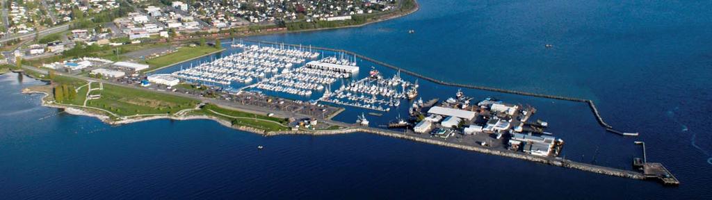
11 Figure 7: Aerial of Wharf District Planning Areas 9
12 Public Access & Circulation Overlay Element Location and Relationship: While the Wharf District consists of seven separate but related planning areas, the public access and circulation element applies to the entire Wharf District. The public access and circulation element highlights two important considerations in this plan. First, it recognizes the need for strong transportation linkages between the Wharf District and the downtown Market District, the marine waters and the Semiahmoo Spit across the channel. Second, it addresses the need for a strong and continuous public access and recreation linkage along Blaine s urban waterfront and waterways. Existing Condition: Figure 9 illustrates the existing condition of the roads and pedestrian routes that service the Marine, Park, and industrial area to the west. Until 2007, Marine Drive consisted of a 20 foot strip of asphalt with informal dirt shoulders and unplanned parking along the park. The road reflects the condition of a declining fishing industry and the presence of a generally outdated and underdeveloped industrial waterfront. However, with the investment of $16 million to expand of the Marina in 1999, it has recently become clear that corresponding improvements are needed. The remaining circulation routes in the Wharf District, consisting of private roads and alleys between buildings, are at the end of their life cycle and need to be upgraded. Key Issues: Poor linkage between the Central Business-Market District and the Wharf District Poor linkage between the CB-Market District and the Water Taxi Marine Drive does not meet minimum urban road standards and does not effectively service the activities and businesses in the Wharf District. The most western 700 feet of Marine Drive is in poor repair with deteriorating riprap, no shoulders. Auto or truck traffic must share this section of the road with pedestrians walking out to Fisherman s Pier. The district lacks strong and continuous public access and non-motorized linkage along its waterfront and waterways. 10

13 Figure 8: Wharf District Aerial of Existing Condition 11

14 Master Plan Vision of Character & Use: A new pedestrian bridge over the railroad tracks is proposed to improve access between the CB-Market District and the Wharf District. These pedestrian and water connections will strengthen business activity by providing a visitor destination in Central Blaine to draw customers from Semiahmoo, and by providing interesting day trips for Wharf District and downtown residents and visitors. Public Access & Circulation Goals: 1. The Wharf District should include a system of roads, trails, boardwalks, sidewalks, bridges, ferries and parking that provides easy and fluid internal circulation within the Wharf District and the CB-Market District, the marine waters and Semiahmoo Spit across the channel. 2. The circulation system should facilitate connectivity between a wide range of water oriented recreational, commercial, and marine activities. 3. The Wharf District should provide continuous public access and recreation linkages to Blaine s urban waterfront and waterways. 4. The Wharf District should include a multiseason indoor/outdoor facility for both community and private events. 5. The Wharf District should include well Figure 9: Conceptual Illustration of City Boardwalk signed public restrooms appropriately distributed throughout the district. Overall Wharf District Design Guidelines: New development and redevelopment projects should take measures necessary to control the quantity and quality of stormwater runoff such that the stormwater runoff from a project complies with water quality standards and contributes to the protection of beneficial uses of the recieving waters. 12
15 Implementation: Circulation: Some road and parking improvements will take place in conjunction with the development of each planning area. Private sector development will be required to include parking and associated road improvements. However, many of the improvements designed to increase public access to the shorelines and enhance circulation will be undertaken by the City and the Port. Priority public improvements include: Pedestrian bridge connecting the upland Market district with the Wharf. The relocation of the ferry terminal to Plover Park and expanded service Significant road improvements to Marine Drive in three phases Gateway and directional signage on all roads and pathways Two mile pedestrian and bike loop from the pedestrian bridge to Fisherman s Pier and back, Construction of a boardwalk that provides for a pedestrian walkway between Lighthouse Park and Fisherman s Pier; Expansion of the marina promenade on the east side of the marina to Plover Park. Construction of additional parking area adjacent to Plover Park (PA2) Construction of a multiple use parking area (PA5b) that services the entire Wharf District. Formalized public parking in the Dakota Commons Planning Area (7) Public Access: Public projects necessary to achieve the public access goals include construction of improvements for a wide range of high quality waterfront recreation areas and facilities with an emphasis on public access to the shoreline. Priority projects include: Enhancement of a large wetland with trail access. Construction of Plover Park Marine Park Improvements Lighthouse Park development Construction of a Lighthouse replica. Construction of a Lighthouse community facility. Interpretative signage along the entire two mile loop trail system. 4 public restrooms (PA 2, 4, 5c, 7) A pedestrian boardwalk on north side of marine drive (PA5d). 13
16 The redesign and construction of a linear park on the last 300 feet of Marine Drive (PA5d). A pedestrian walkway and viewing on the east side of the Dakota Commons Planning Area (PA7). Construction of 5 bird viewing shelters along the two mile pedestrian loop (PA 2, 5a). Pedestrian amenities (benches, etc) Wharf Trail Loop: The most basic component of the public access & circulation element is a two mile interpretive trail winding through the entire Wharf District Interpretive Sign Program - Interprets various historical uses and natural, environmental features for residents and visitors. The development of the Wharf district interpretive program is a key part of the recommended improvement program. The interpretive program offers the potential to attract additional visitors. To be successful, the program will need to be well planned and innovative in its design. As envisioned, the interpretive program would be a cooperative program, with support from Port projects, the City of Blaine, Whatcom Maritime Historical Society, County Parks, State of Washington, and other grant sources. Detailed planning for this program is not part of this plan s scope of work, but the concept is key to the plan s long-range development. This plan sees the interpretive program as a series of simple, integrated elements that can be built into harbor improvement projects as they are implemented. In addition, individual projects and grants can be used to fund and implement incremental additions to the program. The idea is that the program can start small and eventually grow into a significant feature over time. The interpretive program also does not have to have large amounts of funding up front to begin implementation. (Note: The interpretive program will need to be a cooperatively funded feature, with support from all affected jurisdictions.) It is recommended that the program include the following elements: Interpretive displays built into boardwalk and pathway improvements as they are implemented. Displays and upgrading of the west end of Marine Drive with a fishing fleet interpretive theme. Construction of the connecting boardwalk at the east end of the marina, with program elements illustrating the mudflat and its ecology. Displays in the Harbormaster/Boating Center building. 14

17 Figure 10: Public Access & Circulation Overlay Element 15

18 Planning Areas For the purpose of maximizing and enhancing the full value of Blaine s Wharf District, a review of existing conditions by topography, purpose and function aided in developing the potential character of the Wharf District. Through this review, brief descriptions of characteristic places adjacent to and within the Wharf District, each with its own character or function, were identified. Planning Area 1 Gateway to Waterfront (Visual & Physical Access) Location and Relationship: Planning Area 1 is not a part of the Wharf District. However, because it is that part of the CB- Market District that abuts the Wharf District (see Figures 2 &3) it must be considered in the planning process. This section of the CB-Market District provides the best opportunity to establish a variety of ways to access the Wharf District. Planning Area 1 serves as the gateway to the waterfront by providing stunning views, in addition to vehicle and pedestrian connections to the Wharf District. Existing Condition: While downtown Blaine is located on the banks of the Puget Sound, access to the shoreline is limited. Much of the shoreline is isolated by the presence of the railroad with its tracks following the historic shoreline and functionally obstructing any natural connection to both the shoreline and the Wharf District. Currently Marine Drive is the only way to access the Wharf District. Figure 11: Aerial of Existing Conditions-Planning Area 1 16

19 Key Issues: Poor integration between CB-Market District and the Wharf District Preservation of views Master Plan Vision of Character & Use: This section of Blaine s Commercial Market District overlooks the Blaine Harbor and Wharf District, and benefits from the stunning views of the Marina, Drayton Harbor, Semiahmoo and Point Roberts in the distance. As this area redevelops, it will include a Boardwalk along the water side of the Portal Way businesses to further enhance public enjoyment of the marine setting. The preservation of view corridors from street level of Peace Portal Way has been determined to be a high priority. Consequently, view corridors have been identified in Figure 11. These view corridors are intended to protect key views from the street end viewing platforms at G Street and H Street and the boardwalk which will connect these platforms. Figure 12: View Analysis from G & H Street Overlooks A new pedestrian connection bridge over the railroad tracks is proposed to improve access between the Market District and the Wharf District.. This pedestrian connection and subsequent upgraded water taxi connections will strengthen business activity by providing a visitor destination in Central Blaine to draw customers from Semiahmoo, and by providing interesting day trips for residents and visitors of Blaine. Upgraded signage at the Marine Drive is intended to create a Gateway to the Wharf District, making it more visible to traffic on Portal Way and adjacent I-5. The State of Washington is designing a new intersection at Marine Drive, Portal Way and the D Street freeway onramp, which will increase the visibility of this Gateway. Realignment of the railroad crossing and upgrade of Marine Drive and associated bicycle facilities through this Gateway area will connect to the recently upgraded section of Marine Drive to provide a more attractive entrance to the Wharf District. 17

20 Development Guidelines: 1. Improvements, buildings and infrastructure should consider the esthetic presentation to the Wharf District. 2. Lighting should be designed to minimise glare that intrudes into Plover Park and Mariner Village planning areas. 3. The City should consider potential noise levels after 7pm when permitting business on the west side of Peace Portal Way. Implementation: These special projects are designed to improve access to the Wharf District and market the harbor and its unique features. They are intended to attract visitors and promote additional development. The projects are expected to be funded by an array of sources, including Port, City, private, economic development grants, etc. Marine Drive Improvements Improvements are proposed to Marine Drive and the adjacent bicycle trail to connect the upgraded intersection at Peace Portal Way to the recently upgraded portion of Marine Drive. Parking below buildings between H and F Streets (also see public access & circulation element) This is a proposed phased construction project of a well landscaped parking area which will serve both the Market District and the Wharf District overflow parking requirements. Asphalt (ADA) pathway from lower level parking to Marine Drive (also see public access & circulation element) Construction of an asphalt pathway along the fenced railroad track beginning at the parking area between H and F Streets and extending north until it connects with the Marine Drive pedestrian pathway. Figure 13: Planning Area 1 Concept 18


21 Gateway Signage The proposed new Gateway Signage could be designed as an archway over Marine Drive, visible from the upgraded intersection at Portal Way & Marine Drive, adjacent to I-5. The signage should have a historic nautical look to generate interest in businesses and recreational opportunities beyond the sign, and separate this area from the CB-Market District as a unique Blaine neighborhood. Pedestrian Bridge to/from Downtown The economic analysis, public access plan, and this plan agree that providing a better pedestrian link between the harbor and downtown is needed. It is also understood that this is an expensive facility and one the City cannot afford to undertake without significant economic support. Development at the marina and in the downtown also needs to be further along and the area drawing more visitors before the overpass will provide its full benefit. This pedestrian bridge will someday be a valuable community asset. As the downtown and harbor develop, there will be a time when the overpass will be what makes some new project happen. Figure 14: Conceptual Illustration of Bridge Terminus & "H" Street Overlook Figure 15: Conceptual Illustration of Pedestrian Bridge 19

22 Planning Area 2 Plover Park (Recreation & Boat Launch) Location and Relationship: This area is the eastern most Wharf District area running along the BNSF railroad right of way and includes the existing Blaine boat launch, boat launch parking area, and a 100-foot wide corridor along the Burlington Northern Railroad tracks. Proposed improvements in planning area 2 focus on opportunities which can reinforce the quality of circulation, public spaces and enhancing visitor experiences. Existing Condition: Wetlands are present throughout the railroad right of way on the eastern edge of planning area 2. The railroad right of way tends to be poor in drainage with low permeability. In general, overland runoff finds its way through gently rolling terrain via wetland drainage patterns. The public boat launch is located at the southeast corner of planning area 2. This is a popular facility for local and visiting boaters. The launch provides Figure 16: Aerial of Existing Conditions - Planning Area 2 seasonal restrooms for users and parking for 62 boat trailers. Because of IAC funding requirements, the launch, restrooms and parking will likely need to remain at this site. On the west side of planning area 2, there is approximately 2 acres of undeveloped property of which a portion is used as open storage to support the commercial fleet operations. 20

23 Key Issues: Poor connections to CB-Market District Wetlands in 200 railroad right drains poorly Protect harbor and water views from Downtown Siltation near boat launch ramp Master Plan Vision of Character & Use: Existing and proposed open spaces of varying scale will better link Blaine s downtown core with the Blaine Marina and a system of walking tails and recreational opportunities, including an upgraded water taxi to Semiahmoo. A strong connection with the downtown is important to facilitate larger numbers of people within easy walking distance of the waterfront. The pedestrian and water connections between the CB-Market District, Wharf District and Semiahmoo Spit, accessible via an upgraded ferry, is intended to provide a synergy to attract visitors and provide lift to new business activity in all three of these Blaine neighborhoods. Improvements to this area include a new Plover Park named after the water-bird Native to this area, and also after the historic ferry which provided transportation to cannery workers traveling from Blaine to Semiahmoo. The Plover was restored in the 1990 s to serve visitor traffic. This plan envisions an upgraded water taxi service and dock within this planning area to provide more frequent service between central Blaine and Semiahmoo. The Plover Park and parking area will Figure 17: Planning Area 2 conceptual plan serve the Park, foot ferry traffic and a new marina gate. Plover Park and proposed parking area are strategically placed to protect the view corridors from the G Street and H Street street-ends and views of the Harbor and Semiahmoo. Enhanced wetlands and a pedestrian trail through this area will provide open space and recreation for future residents of the Wharf District and an additional visitor attraction to the birders who come to Blaine to see the diverse water-fowl which nest and feed in this area. 21
24 Design Guidelines: Only buildings accessory to Plover Park should be built in this planning area. These building should be limited to a height of no greater than 15 feet. Implementation: These special projects are designed to improve the Wharf District s market potential and reinforce its unique features. The projects are intended to attract visitors and promote additional development. The projects are expected to be funded by an array of sources, including Port, City, private, economic development grants, etc. Blaine Boat Launch Upgrade The floats and pilings on the existing Blaine Boat Launch were installed in 1988 and are in need of replacement. One project in the Wharf District Capital Improvement Plan is to replace these floats and pilings. With the exception of periodic maintenance dredging, no revisions are proposed at this time to the boat ramp, alignment or access. Plover Park A new public park is proposed adjacent to the existing boat launch and restroom facilities. The park would provide a destination for pedestrians using the new pedestrian overpass from the Blaine downtown area, a picnic spot for boat launch and marina visitors, and a recreation area for new Wharf District residents. The park will include pedestrian walkways tied to the network of pedestrian trails within the Wharf District. As demand increases on the existing boat launch restroom facility by pedestrians, park visitors, boat launch users and moorage customers, the restrooms should be improved, better signed and opened year around to serve the general public. Water Taxi Dock A new water taxi dock is proposed in the vicinity of the boat launch and Plover Park. This new facility would be tied to the construction of the new pedestrian overpass over the railroad, and upgrade of the ferry service to a faster, more frequent ferry. This location will be more convenient to the Blaine downtown core and may encourage additional pedestrian use by visitors traveling from downtown Blaine to Semiahmoo. Gate 4 Ramp and Parking Lot A new gate and parking area adjacent to the boat ramp and park will provide more convenient access to the boats on the Gate 1 floats and relieve congestion at the Gate 1 shared parking area. The proposed parking lot will also provide parking for the Plover Park and proposed water taxi dock, and overflow parking for businesses in planning area 3. 22

25 Pintail Marsh This 2 acre degraded wetland will be enhanced to include open water and emergent wetlands. The Cain Creek outlet can be relocated so that it provides the marsh with a constant source of freshwater. The marsh in turn will flow under the Marine Drive bridge so that the mudflats will continue to receive the same supply of Cain Creek water in the same location. The creation of several small upland islands in this marsh should provide excellent resting and nesting habitat for both local and migrating bird species. The aquatic environment will provide habitat for a wide variety of invertebrates, amphibians and some fish species. Figure 18: Conceptual Drawing of Pintail Marsh 23

26 Planning Area 3: Mariner Village (Mixed Use) Location and Relationship: Area 3 is bound by Marine Drive on the north and Area 2 on the east and south and Blaine Marina on the west. This area is closest to the existing Downtown core and most likely to benefit from and contribute to redevelopment of the Blaine Market District. Area 3 is also located furthest from the exiting fish processing, commercial fishing fleet berthing, fueling and boat repair facilities at the West end of Marine Drive, and is least likely to be impacted by the noise and odors associated with the working waterfront. The area is located between existing Marine Park and proposed new Plover Park and surrounded by existing and proposed walking and nature trails to provide recreation and open space for future residents and visitors. Harbor views to the West and water views to the North provide an ideal setting for a mixed-use redevelopment. Existing Condition: The Port has three weblockers, two of which are located in Area 3. These two buildings are wood pole structures with open bays for gear storage. The weblockers are some distance from Figure 19: Aerial of Existing Conditions-Planning Area 3 the commercial fleet berthing area, reducing user convenience. These buildings are in a location where future commercial development will likely occur. At the time of this study, only 65% of all three existing weblockers are being used by commercial fishers and leaseholders. Some of these lockers are not filled with commercial gear, but are being used to store other things such as household items. With this in mind, an expanded west end web locker in Area 6 would probably be able to meet all the commercial needs in the future. There is approximately 3 acres of undeveloped property, of 24

27 which a portion is used for both short and long term storage of fishing gear and surplus material supporting commercial fleet operations. An existing boat repair and storage yard with some marine related retail sales is also located on approximately 2 acres in this area. This area contains three commercial/retail or office structures the Dockside Place Mall a 30,000± square-foot mixed-use office/retail structure, the Pavilion Building, a small space converted from the former Visitors Center to a retail shop space, and Phase 1 of the new Northern Light Building (6460± square feet). Key Issues: Weblockers are some distance from commercial fleet and in poor condition Redevelopment is dependent on market demand Millholin Drive is a substandard private road, insufficient to support expanded development. View corridor preservation Master Plan Vision of Character & Use: This area provides for a variety of uses with residential uses above the ground floor, while protecting downtown views with delineated view corridors and stepped height limits. Pedestrian-oriented street edges and streetscapes adjacent to buildings facing north along Marine Drive are envisioned for this area. Proposed road and utility upgrades to serve the mixed use development are contemplated for Millholin Drive. Parking on the ground level below residential uses or offices and within Figure 20: Planning Area 3 Conceptual Plan view corridors between buildings should be ample to serve future development. Retail businesses, restaurants and services on the ground floor could meet the needs of future residents and visitors and compliment exiting and future Market District businesses. A small hotel or conference center along Marine Drive could house visitors and provide an ideal setting for weddings, community events and business meetings. 25

28 Design Guidelines: 1. The village should be developed in a stair step manner so that buildings in the northwest corner of the planning area reach the highest elevation with incremental reduction in building heights to the south. 2. All buildings in the village should be accessed from Millholin Drive. 3. Sidewalks and street trees should be located along the south side of Marine Drive and on both sides of Millholin Drive. This can be accomplished at as the village develops. 4. On-site parking will be required with landscaping Implementation: These special projects are intended to attract visitors and promote additional development. The projects are expected to be funded by an array of sources, including public and private investment and economic development grants. Weblocker Demolition: Web lockers 2 and 3 will need to be demolished prior to redevelopment of Area 3. Figure 21: Conceptual Area 3 Streetscape Milhollin Drive Upgrade: An upgrade of Millholin Drive to a residential street with sidewalks and street trees is proposed in conjunction with the redevelopment of planning area 3. Harborside Promenade: A new promenade is proposed along the east end of the harbor, similar to the promenade along other portions of the harbor. 26

29 Planning Area 4: Harbor Gateway (Marina Support) Location and Relationship: This area is west of Area 3 on the south side of Marine Drive. It is a narrow strip of land located between the recently upgraded portion of Marine Drive and site of City s proposed Water Reclamation Facility and Gates 2 and 3 of the Blaine Marina. Existing Condition: Much of this area is already developed and includes the Harbor Master Offices, Boating Center, the Fishermen s Memorial, marina gatehouses 2 and 3, parking and promenade. The parking area, landscaping and promenade with a covered outdoor seating area were upgraded in 1998, providing a popular pedestrian route, harbor viewing and community activity area. Figure 22: Aerial of Existing Condition-Planning Area 4 27

30 Key Issues : Already mostly developed Maintain pedestrian access and amenities Additional shop space needed for Marina maintenance operations and support equipment View corridor preservation Master Plan Vision of Character & Use: New uses should primarily focus on marina support services along with tourist oriented commercial and water enjoyment uses. Future use of the small development pads within this area could include marine-related retail uses, charter or whale watching offices, boat sales or small café or coffee shops serving primarily marina customers. New buildings in this area are intended to be of similar size and scale to the exiting Boating Center and Gate Houses, with height limited to two stories within the view corridors. Design Guidelines: 1. Because planning area 4 is in the view corridor, buildings should be limited to a height of no greater than 25 feet. 2. Future commercial uses should be services supporting water enjoyment, tourism, marina & boat owner needs. Figure 23: Planning Area 4 Conceptual Plan 28

31 Implementation: These special projects are intended to attract visitors and promote additional development. The projects are expected to be funded by an array of sources, including public and private investment and economic development grants. Fishermen s Memorial The existing Fishermen s Memorial is a well-maintained and landscaped part of the marina. It could, however, benefit from a more visible location. One recommendation of the 1998 Harbor Plan was to develop a new memorial at a site closer to the commercial fleet. A more appropriate location could be located on the pier at the west end of Marine Drive. This site would allow the memorial to overlook the fleet as it leaves and returns to the harbor. Another potential location would be in the plaza when Lighthouse Park is finished. Any decision on the memorial would require the support of the memorial s sponsor s. Harbor Master s Shop and Equipment Storage An addition to the Blaine Boating Center is proposed to provide additional office space, storage and maintenance space. The expansion will be a one story addition located to east of the existing building, approximately 20 x 48, blended to match the style of the current building. Figure 24: Area4 Conceptual Illustration 29

32 Planning Area 5: Waters Edge (Public Access) Location and Relationship: This planning area is owned and managed by the City and/or Port for public use. It consists of four integrated recreation areas, each with specific characteristic and uses. Together they are intended to provide a broad range of opportunities for both visitors and the community to connect with the shoreline habitat, its marine waters, and its wildlife. This area is also intended to complement the marina with increased pedestrian crosswalks on Marine Drive, an overflow parking facility during high marina use and its recreational attraction. Existing Condition: Marine and Lighthouse Parks total 10.1 acres with an amphitheater, a large wood recreation platform for events, four birding shelters, interpretive signs, and several large pieces of art. It also has 3,680 lineal feet of shoreline. The trail along the adjacent upland area is 2790 feet Figure 25: Aerial of existing conditions - Planning Area 5 long. It also has 4 viewing shelters and several viewing benches, and a stationary viewing scope. 30

33 Key Issues : Marine Park facilities are at the end of their life cycle The City does not currently have the resources to maintain and improve the park. The shoreline on the western half of the park is eroding. Existing shore stabilization materials are ineffective and pose a safety hazard to the public. A new wastewater facility is planned to be constructed on the most western portion of the park. The pedestrian trail ends at the park s western terminus. There is not pedestrian access to Fisherman s Pier. Visual access to the water from the road is limited along the entire length of Marine Park. There are currently no overnight RV accommodations for special event participants. Master Plan Vision of Character & Use: The planning area encompasses the entire northern shoreline of the Wharf District. The City Parks Plan envisions the parks, pier, boardwalk, and trails are to be dedicated for public access to the shoreline with a particular emphasis on viewing its rich seasonal wildlife. This planning area is also intended to complement the marina with increased pedestrian crosswalks on Marine Drive and an overflow parking facility during high marina use. The western portion Marine Park has been renamed Lighthouse Park for two reasons; first, in recognition of the planned construction of the lighthouse replica on the most western portion of the park; and second, because the western half of the park has been Figure 26: Planning Area 5 Conceptual Plan 31
34 designated an active park designed to encourage physical access to the water. By contrast, the eastern half of the park will remain Marine Park and managed as a passive park. This in response to the massive numbers of migrating water birds that feed and rest in the protected backwater mudflats and fresh water that Cain Creek provides. Design Guidelines: 1. Landscaping in this area should consist of low lying vegetation and grass. Open space and views of the water should take priority over tree plantings and structures. 2. Multi-purpose bird viewing shelters should take priority in future planning and development of this area. 3. The planned restroom facility in the wastewater building should be well signed, open year round and service the general public. Planning Area 5A: Marine Park Marine Park is intended to be a passive park. As a part of the two mile Wharf Trail loop, it will provide a natural shoreline experience with viewing stations that will provide an excellent opportunity to view water birds, particularly migratory birds that are present in large numbers during the winder months of the year. Its primary characteristics are open space and pedestrian access along the marsh, mudflats and shoreline. During the summer, the Marine Park Amphitheater provides a place for community performances and events and the Orca gathering area provides opportunities for children s parties and picnics. Implementation: These special projects are intended to attract visitors and promote additional development. The projects are expected to be funded by an array of sources, including public and private investment and economic development grants. Prior to making further improvements the City will prepare a landscape plan for Marine Park that incorporates the policy and direction of the City of Blaine Park and Recreation Plan. The Plan shall be reviewed by both the Port of Bellingham and the Parks Board before final City Council Approval. At a minimum the Plan shall include: 1. Additional Bird viewing shelters, 2. Interpretive signage, 3. Modification and expansion of the outdoor theater 4. Update Orca gathering area. 5. Revised landscaping 32

35 Planning Area 5B: Festival Square/Public Parking This 2 acre property is owned by the City. It is not intended to be included into the park system but is intended to be used in a manner that compliments and enhances the entire Water s Edge planning area. In the long term this may include support structures but in the immediate future this area is envisioned to serve the public by providing centrally located public parking and, as the need arises, a festival area. The site should include utilities and other amenities to service such events and related overnight accommodations. This area could be designed to blend into the larger recreation area with easily accessible pedestrian trails to the east, west or south to the marina. Festival Square is merely an open space for special events such as crafts fairs, flea markets, boat shows, car shows, etc. This vision proposes a completely flexible open area with limited new landscaping and minor utility outlets for power or lighting. Festival Square could be an inexpensive way to create a colorful, active place that attracts visitors to the park and harbor. When coordinated with the upgrading of Marine Drive and with the new parking proposed for the north side of Marine Drive, this would be a very attractive public amenity. Implementation: These special projects are intended to attract visitors and promote additional development. The Figure 27: Conceptual Cross Section of Festival Square projects are expected to be funded by an array of sources, including public and private investment and economic development grants. Prior to making further improvements the City will prepare a landscape plan for the Parking Festival planning area. The Plan shall be reviewed by both the Port of Bellingham and the Parks Board before final City Council Approval. At a minimum the Plan shall include: 1. Parking space for at least 50 vehicles; 2. Special event overnight accommodations; 3. Pedestrian pathways to both Marine and Lighthouse Park; 4. Over time, educational and/or recreational buildings and uses, commercial or noncommercial, maybe added to this planning area when determined to be consistent with the vision and direction of the City. 33

36 Planning Area 5C: Lighthouse Park Lighthouse Park is intended to be an active park that provides a wide range of recreational activities. The most westerly side of the park will include a scaled replica of the lighthouse that stood for 39 years on pilings off shore from Semiahmoo Spit. The Park also will contain the City s water reclamation facility which will include an atrium on the west side for a community gathering or special events. Between the lighthouse and the atrium, a plaza and water feature, which connects the two, will provide all of the functions normally associated with a plaza. A major characteristic of the park is its three pocket beaches which will allow children, young and old to dip their toes in the marine waters of Semiahmoo Bay. The park will also include a picnic area and a large grassy hill to either fly a kite or just lie on and watch the clouds. Figure 28: Conceptual Site Plan of Lighthouse Park 34

37 Implementation: These special projects are intended to attract visitors and promote additional development. The projects are expected to be funded by an array of sources, including public and private investment and economic development grants. Prior to making further improvements the City will prepare a landscape plan for Lighthouse Park. The Plan shall be reviewed by both the Port of Bellingham and the Parks Board before final City Council approval. At a minimum the Plan shall include: 1. Lighthouse Park plan and construction; 2. Scaled Lighthouse replica; 3. Plaza; 4. Community use area/building; 5. Waterworks feature; 6. Shoreline restoration including 3 pocket beaches; 7. Trails; 8. Picnic sites, and 9. Bird shelters. Figure 29: Concept of Lighthouse Park showing WRF, pocket beach & Lighthouse replica 35
38 36

39 Planning Area 5d: The Wharf This Planning area is identified as the Wharf because the overall visual effect will be similar to an actual over water wharf. The straight and structured character of the wharf section of the road will be very different from that of Marine Drive to the east with its landscaping and water gardens. If done properly, one will have the perception that they are driving or walking from the upland out onto a wharf. The Boardwalk on the north side of the road will provide much needed pedestrian access from Lighthouse Park to Fisherman s Pier at the westerly terminus of the Wharf District. The locally popular pier provides a large over water structure that can be used for fishing, crabbing or viewing. It includes a floating dock that is used by visiting boaters and also serves a pickup and drop-off location for a foot passenger ferry or water taxi. Implementation: Figure 30: A bird's eye view of existing conditions at "The Wharf" These special projects are intended to attract visitors and promote additional development. The projects are expected to be funded by an array of sources, including public and private investment and economic development grants. 37

40 Wharf Gateway Sign Located at the western end of Lighthouse Park, where the vehicular right of way becomes reduced, the proposed new Wharf Gateway Signage could be designed as an archway over Marine Drive. The signage should have a historic nautical look to help generate a feeling of driving or walking from the upland out onto a wharf. Road Improvements The road is planned to be reduced from 22 feet to 20 feet from the western end of Lighthouse Park and extends to the working, loading docks on the west side of the fish and crab processing canneries in planning area 7. Just beyond the loading dock there will be a small parking area and turnaround. Figure 31: Gateway Signage Concept Lighthouse to Pier Boardwalk A pedestrian route with a boardwalk character is proposed along the northern edge of the roadway to separate pedestrians from traffic. The road right-of-way is narrow along this corridor, so the proposed boardwalk may consist of a stamped concrete raised sidewalk, with railings to give it a wharf character. Linear Park to Fisherman s Pier Just beyond the loading dock a small parking area and turnaround will provide up to 4 parking spaces for Fisherman s Pier. A linear park with a 12 wide drivable asphalt pathway will provide easy ADA, pedestrian, bike and cart access, to the pier. Emergency and maintenance vehicles will also be able to use the path with the removal of a bollard. Fisherman s Pier The existing wood pier at the west end of Marine Drive is recommended for upgrading as a pedestrian access only view point. The Port has recently invested approximately $75,000 in improvements to Fisherman s Pier. These improvements include decking repairs, benches, planters, and other miscellaneous fixtures. Other improvements recommended in this plan include special interpretive displays. The view point s main feature will be an interpretive kiosk. The purpose of the kiosk is interpretation of the harbor s history and the subsequent changes that have developed over time. 38

41 Planning Area 6: Shipyard Industrial Park (Industrial) Location and Relationship: This area includes the land mass on the south side of Marine Drive and west of the Marina, located behind the Dakota Building, the site of the former Harbor Café and public parking lot. Providing support services for boaters, fishermen and employees, planning area 6 is preserved for continued marine-related commercial and industrial use. Existing Condition: This area at the western end of the harbor contains a variety of facilities, most of which support the commercial fishing and crabbing fleet. Specific uses include weblocker storage, ship and boat repairs, seafood processing and a fuel facility. In addition a furniture/appliance store occupies a portion of the site. With the exception of Port-owned web locker #1, most structures in the industrial area are privately owned on Port or DNR land. Figure 32: Aerial of existing conditions - Planning Area 6 39
42 Key Issues : Preserving land for water- dependent industry Fuel facility berthing area and equipment needs to be improved Proximity to existing Commercial fishing fleet working dock Deferred maintenance of marine infrastructure i.e. bulkheads need to be addressed Reserving space for Weblocker re-alignment Addressing historical environmental contamination from shipyard and fueling activities Master Plan Vision of Character & Use: Area 6 is preserved for marine-related commercial and industrial uses, serving primarily the commercial fishing, boat building and boat-repair and service industry. This area is one of the limited areas in Whatcom County which has access to protected marine waters suitable for large vessel moorage, fueling and servicing. The saw tooth dock in this area provides berthing and off-loading facilities for commercial fishing vessels, and the adjacent web-locker provides storage for nets and gear. The existing Web-locker #1, adjacent to the saw tooth dock, is an older facility in need of upgrade. By itself, it is not large enough to serve the entire fishing fleet in Blaine. The existing web locker could be replaced with a larger web locker sized to serve the entire fleet. This facility could include lofts for commercial fishing gear, or a second story to serve recreational boating needs, and could be realigned or located closer to Marine Drive to allow space for expansion of boat repair facilities. Figure 33: Planning Area 6 Conceptual Plan The area adjacent to the existing fuel docks is in need of upgrade to better serve the needs of commercial and recreational boaters. Services could include additional boat repair and service facilities, an additional hoist, upgraded fueling facilities, and retail goods and services for fishers, fishery workers and visiting commercial and recreational boaters. 40

43 Design Guidelines 1. This area is not suitable for residential uses or hotels as long as there are active commercial fishing, fish processing and shipyard uses in this area. 2. Height should be limited to two stories within the designated view corridor. Figure 34: Conceptual Illustration of Building Concept for Planning Area 6 & 7 41
44 Implementation: These special projects are intended to attract businesses and promote additional use of facilities. The projects are expected to be funded by an array of sources, including public and private investment and economic development grants. Weblocker Demolition and Reconstruction Existing Weblocker #1 Is proposed to be replaced by a larger 2 story Weblocker located closer to Marine Drive to allow expansion of the fish processing and boat repair facilities located behind this facility. Bulkhead Repairs A number of the bulkheads and adjacent decking within Area 7 are in need of replacement or repair. Upgrade of the marine infrastructure in this area will occur in conjunction with environmental remediation as the area redevelops. Funding will be through public/private partnerships Upgraded Fueling Facilities Upgrade of the fueling facilities would be funded by the operator of this facility or through a public private partnership to better serve fueling facility customers. New Haul Out An additional hoist has been proposed to better serve the needs of mid-size boats needing to be hauled out for repair. This facility would be funded by the operator of this facility or through a public/private partnership. 42
45 Planning Area 7: Dakota Commons (Commercial) Location and Relationship: Area 7 abuts the south side of Marine Drive and is located north of Area 6. This area has historically contained waterrelated commercial and industrial uses such as fish processing. It also included a popular local restaurant and bar, which served fishermen, area employees and the visiting public. The restaurant was demolished in The Dakota Building, located in this planning area, has been home to offices and a fresh fish market in the past, but is currently vacant. Existing Condition: This area at the western end of the harbor, fronting Marine Drive contains fish processors and crab shipping facilities. In addition, a parking lot that serves Fisherman s pier occupies a portion of the site. Most structures in this area are privately owned on Port or State-owned land. Figure 35: Aerial of existing conditions - Planning Area 7 43

46 Key Issues : A Washington State preference for water dependent uses on State owned property Preserving waterfront property for water related uses Proximity to the working waterfront Proximity to main arterial and public access areas Address parking and circulation for business and visitors Maintain visual and physical access to working waterfront Master Plan Vision of Character & Use: As this area is redeveloped, visual access to, the working waterfront is to be maintained. Over time water-enjoyment and commercial uses will be integrated to support business and tourism. The area along Marine Drive could be redeveloped as a commercial center to support local marine related businesses and visitors. A restaurant, coffee shop, offices or retail shops oriented to boaters, fishermen or area visitors would do well in this location. Other office, light industrial, civic or tourism uses compatible with a marine industrial setting would also be appropriate. Design Guidelines 1. Residential uses or hotels should not be allowed due to the area s proximity to the working waterfront as long as adjacent fish processing and boat repair facilities are in operation. 2. Future commercial uses should be oriented toward supporting either the surrounding business activities or tourism and water enjoyment activities. Figure 36: Planning Area 7Conceptual Plan 44
Zoning and Development Considerations in the Boothbay Harbor Maritime/Water Dependent District
 Zoning and Development Considerations in the Boothbay Harbor Maritime/Water Dependent District Bob Faunce Lincoln County Planner Lincoln County Regional Planning Commission Board of Selectmen and Planning
2.1 Location and Size
 2.0 Context 7 2.1 Location and Size The Saanich Penninsula The study area is centrally located within the Town boundaries on the east side of Highway 17, which runs through Sidney in a north-south direction.
City Center Neighborhood Plan
 [1] City Center Neighborhood Plan As adopted by Ordinance No. 2014-09-049 and amended by Ordinance Nos. Formerly CBD Neighborhood as adopted by Ordinance No. 8868 and amended by Ordinance Nos. 8946, 9693,
M i s s i o n B a y W a t e r f r o n t
 114 M i s s i o n B a y W a t e r f r o n t Character of the Area: The Mission Bay Waterfront extends from Pier 48 at China Basin Channel to 18th Street in the Central Basin. This area of the waterfront
Bourne Downtown Site Planning
 Prepared for: The Town of Bourne, MA In Cooperation with: Bourne Financial Development Corporation Prepared by:, Inc. June 24, 2009 Table of Contents Introduction and Summary... 1 Site Existing Conditions...
Gold Line Bus Rapid Transit Transit Oriented Development (BRTOD) Helmo Station Area Plan
 Helmo Station Area Plan") Appendix F Gold Line Bus Rapid Transit Transit Oriented Development (BRTOD) Helmo Station Area Plan Introduction and Purpose of the Plan The Gold Line Bus Rapid Transit facility is an eleven-mile dedicated
Appendix F Gold Line Bus Rapid Transit Transit Oriented Development (BRTOD) Helmo Station Area Plan Introduction and Purpose of the Plan The Gold Line Bus Rapid Transit facility is an eleven-mile dedicated
{Best Practices. Summary of Tools, Strategies and Best Practices from 11 Michigan Case Study Communities
 Case Studies Michigan Coastal Community Working Waterfronts { Summary of Tools, Strategies and from 11 Michigan Case Study Communities Table of Contents Zoning...2 Community and Stakeholder Collaboration
Chapter 6. Overall Vision RECOMMENDATIONS. More Trail and Trail. Connections. Equal Access to Park. Facilities and Programs. Water Access.
 Overall Vision More Trail and Trail Connections Equal Access to Park Facilities and Programs Water Access Environment Variety Chapter 6 RECOMMENDATIONS Chapter 6 The following recommendations for park,
V. Vision and Guiding Principles
 V. Vision and Guiding Principles The Master Plan for the Powers Ferry Corridor seeks a foundation in the desires of the community. At times, various elements of the community offered opposing viewpoints,
PLANNING ADVISORY BOARD AGENDA OCTOBER
 ! City of Langley PLANNING ADVISORY BOARD AGENDA OCTOBER 1, 2014 3-5pm LANGLEY CITY HALL - 112 2 nd Street, Langley WA 1) Call to Order and Roll Call 2) Approval of the Minutes September 10, 2014 3) Public
Mark-up of the effect of the proposed Bronte Village Growth Area OPA No.18 on the text of section 24, Bronte Village, of the Livable Oakville Plan
 Mark-up of the effect of the proposed Bronte Village Growth Area OPA No.18 on the text of section 24, Bronte Village, of the Livable Oakville Plan Notes: This document is provided for information purposes
The transportation system in a community is an
 7 TRANSPORTATION The transportation system in a community is an important factor contributing to the quality of life of the residents. Without a sound transportation system to bring both goods and patrons
Hockessin Community Redevelopment Plan
 Hockessin Community Redevelopment Plan 3.1 Introduction The Community Redevelopment Plan for the Village of Hockessin is the result of the people s vision for a distinct village center that serves as the
Manchester. Vision for Manchester
 Manchester Vision for Manchester The Manchester Community Plan is a statement of the community values and aspirations for the future. This is an effort to recognize what originally attracted visitors in
10.0 Open Space and Public Realm
 10.0 Open Space and Public Realm 10.0 Open Space and Public Realm The Public Open Space System is comprised of: outdoor spaces available for public use that are either publicly owned (e.g., parks and
Port Lavaca Future Land Use
 Port Lavaca Future Land Use Introduction The City of Port Lavaca is beginning to see sustained growth, after many years of relative stable population. New single family homes, apartments, and businesses
The University District envisions, in its neighborhood
 Envisioning the University District Link Light Rail in Seattle s neighborhoods CIY OF SEALE CONCEP-LEVEL SAION AREA PLANNING RECOMMENDAION RESOLUION # 30165 EXHIBI L Vision 08.2000 he University District
CHAPTER ONE INTRODUCTION
 1.0 Introduction Bellingham s central waterfront is in a state of transition from its long history as an active industrial site to a new mixed-use neighborhood. Over the past several years, the Port of
DISCUSSION TOPIC: ST JOHNS RIVER & ITS TRIBUTARIES (BPII) 2030 COMPREHENSIVE PLAN POLICES AND REGULATORY FRAMEWORK
 2030 COMPREHENSIVE PLAN POLICES AND REGULATORY FRAMEWORK") DISCUSSION TOPIC: ST JOHNS RIVER & ITS TRIBUTARIES (BPII) 2030 COMPREHENSIVE PLAN POLICES AND REGULATORY FRAMEWORK St. John s River & Its Tributaries Issue Summary: The St. Johns River is an important
DISCUSSION TOPIC: ST JOHNS RIVER & ITS TRIBUTARIES (BPII) 2030 COMPREHENSIVE PLAN POLICES AND REGULATORY FRAMEWORK St. John s River & Its Tributaries Issue Summary: The St. Johns River is an important
Transportation. Strategies for Action
 Transportation A major priority for the Overlake Neighborhood is to develop a multimodal transportation system. To achieve this system, a balance has to be found among travel, circulation and access needs;
CHAPTER 7: Transportation, Mobility and Circulation
 AGLE AREA COMMUNITY Plan CHAPTER 7 CHAPTER 7: Transportation, Mobility and Circulation Transportation, Mobility and Circulation The purpose of the Transportation, Mobility and Circulation Chapter is to
3.1 Existing Land Use
 3.0 Land Use This strategy has been developed taking into account the position of the Town of Sidney as the economic center of the Saanich Peninsula. It acknowledges existing land use patterns in the downtown
STUDY AREA. Tonight s Agenda. Project Tasks Completed. Next Steps. Town of Oyster Bay Eastern Waterfront Community Vision & Revitalization Plan
 Town of Oyster Bay Eastern Waterfront Community Vision & Revitalization Plan Public Meeting January 27, 2009 Opening Remarks Presentation Tonight s Agenda Introduction Study Area Overview Public Participation
Prepared by: a for the of the. Waterspace Strategy Sustainable Development Liverpool South Docks
 Prepared by: a for the of the Waterspace Strategy Sustainable Development Liverpool South Docks a Waterspace Strategy for the Sustainable Development of the Liverpool South Docks British Waterways identified
Popp s Ferry Causeway Park Back Bay Environmental Educational Center CASHIO COCHRAN LLC
 Popp s Ferry Causeway Park Back Bay Environmental Educational Center CASHIO COCHRAN LLC A LIMITED LIABILITY COMPANY Popp s Ferry Causeway Park Master Plan Prepared for: City of Biloxi Department of Parks
ASHTABULA COUNTY COASTAL MANAGEMENT PLAN
 Location Ashtabula County, Ohio Planning Grantwriting ODNR, Office of Coastal Management, $25,000 Local Match $25,000 Size 21 miles of coastal area Professional Services 2012 Project Team Randy Mielnik,
Highest & Best Use Study Marina Park Lands
 Executive Summary of Report MARCH 2006 TABLE OF CONTENTS 1. Introduction...1 2. Study Process...2 3. Highest And Best Use Program...3 4. Concept Plan...8 5. Public Area Animation...9 6. Marina Park Implementation
Waterfront Development Master Plan
 PORT of VANCOUVER USA Vancouver, WA Waterfront Development Master Plan DRAFT - FINAL CONCEPTUAL MASTER PLAN PROJECT TEAM NBBJ Heritage Research Associates JLA Kittelson Associates Leland Consulting Group
1. Parks & Recreation Neighborhood Parks Community Parks Special Use Sites 2. Open Space 3. Trails
 Appendix A: Park Classifications The intent of parks and recreation classifications is to aid in making acquisition and design decisions for park sites, facilities and the organization of recreation space
Carlsbad Village Redevelopment Concept Summary of Features
 Carlsbad Village Redevelopment Concept Summary of Features Calthorpe Associates November 5, 2003 The Redevelopment Concept illustrates a vision for the future of Carlsbad Village. The overall vision of
The Vision. Photo provided by The Minervini Group. 46 Vision, Objectives & Strategies
 Vision, Objectives & Strategies The is the public framework and guide for future development of the Grand Traverse Commons. The establishes public polices for infrastructure, the preservation of natural
PHASE 3-4 PARKS SOUTH PARK AND CHANNEL PARK
 PHASE 3-4 PARKS SOUTH PARK AND CHANNEL PARK Sheet List L1.0 L2.0 L3.0 L4.0 L5.0 L6.0 L7.0 L8.0 L9.0 L10.0 L11.0 L12.0 L13.0 L14.0 L15.0 L16.0 L17.0 L18.0 L19.0 L20.0 L21.0 L22.0 Cover Open Space Context
Keyport. Vision for Keyport
 Keyport Vision for Keyport Keyport is a rural, historic waterfront village bounded and limited in size by its natural borders of water and the Naval Undersea Warfare Center. The community consists primarily
Village of Fair Haven Goals & Objectives
 Village of Fair Haven Goals & Objectives 1 Natural Environmental Quality & Aesthetics Embrace policies and programs that preserve and enhance the Village s natural resources, environment, water quality,
Pedestrian and Bike Bridge LOGO
 6.2.2 Pedestrian and Bike Bridge The proposed pedestrian and bike crossing re-envisions the existing bridge at Pismo Creek on Cypress Street. The bridge is currently underutilized by vehicular through
Please read the entire document
 projects impacting the waterfront revitalization area. The waterfront revitalization area of the town will have to subareas to the west and east of the village. Page 6 of 6 Wayfinding master plan create
EXISTING COMPREHENSIVE PLAN
 EXISTING COMPREHENSIVE PLAN Town Center Land Use Element: V. LAND USE POLICIES Town Center Mercer Island's business district vision as described in "Your Mercer Island Citizen-Designed Downtown" was an
New Brighton Park Shoreline Habitat Restoration Project
 Vancouver Board of Parks and Recreation and Port Metro Vancouver New Brighton Park Shoreline Habitat Restoration Project Conceptual Design Public Consultation August 26 September 9, 2015 Discussion Paper
Policies and Code Intent Sections Related to Town Center
 Policies and Code Intent Sections Related to Town Center The Town Center Vision is scattered throughout the Comprehensive Plan, development code and the 1994 Town Center Plan. What follows are sections
PORT OF VANCOUVER WATERFRONT DEVELOPMENT. Concept Development Plan City Center Redevelopment Authority April 20, 2017
 PORT OF VANCOUVER WATERFRONT DEVELOPMENT Concept Development Plan City Center Redevelopment Authority April 20, 2017 Port History PORT ESTABLISHED 1912 TERMINAL 1 ACQUIRED 1925 GWM SIGNS LEASE 1935 HARBOR
Preliminary Sketch Plan for Fort Hunter Park
 Preliminary Sketch Plan for Fort Hunter Park Public Presentation November 19, 2009 Dauphin County Parks and Recreation 100 Fort Hunter Road Harrisburg, PA 17110 (717) 599-5188 www.dauphinc.org THOMAS COMITTA
TOWN COUNCIL / PLANNING COMMISSION
 Workshop #3 TOWN COUNCIL / PLANNING COMMISSION January 20, 2011 Consultant Team In Attendance Tonight BMS Design Group Nevada City and San Francisco Michael Smiley, AICP, ASLA Partner-in-Charge Nancy L.
Highland Falls Waterfront Redevelopment Feasibility Study Village Board Meeting March 20, 2017
 Village Board Meeting March 20, 2017 Agenda I. Public Meeting #1 Visioning Summary II. Public Meeting #2 Comment Summary III. IV. IV. Case Study: Milton Train Station Schematic Design Concepts Schedule/Next
Sub-committee on Harbour Plan Review of Harbour-front Enhancement Committee. Ninth Meeting
 Sub-committee on Harbour Plan Review of Harbour-front Enhancement Committee Ninth Meeting Date: 5 October 2005 Time: 3:30pm Venue: Conference Room 15/F, North Point Government Offices, 333 Java Road, North
HURON WATERFRONT DEVELOPMENT AND AMPHITHEATER
 AWARD WINNING PROJECT Location Huron, Ohio Architectural, Engineering, Site, Landscaping, Planning, Survey, Grant Administration, Construction Administration Cost $285,000 Amphitheater $300,000 Marina
Queensborough Eastern Neighbourhood Node. Community Open House
 Queensborough Eastern Community Open House The Vision The Queensborough Eastern will become the heart of eastern Queensborough. Through a sensitive mix of viable commercial and residential areas, the neighbourhood
BROOKHILL NEIGHBORHOOD MODEL ZONING MAP AMENDMENT PREFACE TO APPLICATION
 BROOKHILL NEIGHBORHOOD MODEL ZONING MAP AMENDMENT PREFACE TO APPLICATION June 15, 2015 Revised: August 1, 2016 I. VISION Brookhill is a proposed community based upon the principles of Albemarle County
SECTION II SECTION II STATEMENT OF GOALS, OBJECTIVES, PRINCIPLES, ASSUMPTIONS, POLICIES AND STANDARDS
 STATEMENT OF GOALS, OBJECTIVES, PRINCIPLES, ASSUMPTIONS, POLICIES AND STANDARDS 1 2 STATEMENT OF GOALS, OBJECTIVES, PRINCIPLES, ASSUMPTIONS, POLICIES AND STANDARDS INTRODUCTION The New Jersey Municipal
City of Tacoma Planning and Development Services
 Agenda Item D-3 City of Tacoma Planning and Development Services To: Planning Commission From: Stephen Atkinson, Associate Planner, Planning Services Division Subject: Land Use Designations - Phase 2 Meeting
A. WHAT IS A GENERAL PLAN?
 I. Introduction A. WHAT IS A GENERAL PLAN? A general plan is the planning guideline for the future of a city. It contains goals and policies which regulate urban development, the protection of the natural
HAYDEN ISLAND. Portland s Only Island Community. FINAL CONCEPT PLAN April 2008
 HAYDEN ISLAND Portland s Only Island Community FINAL CONCEPT PLAN April 2008 Introduction Hayden Island is the only island neighborhood in Portland and it provides a unique setting to its residents and
PARKS. Chapter Introduction
 Chapter 4. PARKS 4.1. Introduction This Parks Element of the 2016 Comprehensive Plan Update provides direction and guidance, based on citizen input, in order to improve and maintain the City s existing
Urban Design Manual PLANNING AROUND RAPID TRANSIT STATIONS (PARTS) Introduction. Station Study Areas
 Introduction. Station Study Areas") 111111 PLANNING AROUND RAPID TRANSIT STATIONS (PARTS) Introduction The ION rapid transit system will link Waterloo, Kitchener and Cambridge through a central transit corridor (CTC). There are a number
111111 PLANNING AROUND RAPID TRANSIT STATIONS (PARTS) Introduction The ION rapid transit system will link Waterloo, Kitchener and Cambridge through a central transit corridor (CTC). There are a number
RECREATION AND OPEN SPACE ELEMENT GOALS, OBJECTIVES, AND POLICIES
 RECREATION AND OPEN SPACE ELEMENT GOALS, OBJECTIVES, AND POLICIES Goal 7 To provide park facilities, recreation programs, and open space resources that are safe, adequate, and accessible to all City residents,
City of Chickasaw Land Use Comprehensive Plan 2030 Chapter5-Draft(2)Public review_
Public review_") Land Use Land Use refers to the activity or development characteristics of a given parcel of land. The Land Use Plan presented in the following pages, represents the City of Chickasaw s official position
Land Use Land Use refers to the activity or development characteristics of a given parcel of land. The Land Use Plan presented in the following pages, represents the City of Chickasaw s official position
Cold Lake Marina Master Plan
 Cold Lake Marina Master Plan Intro to Team Moffatt & Nichol is recognized throughout the world for our role in the revitalization and redevelopment of urban waterfronts, including the evolution of modern
This Review Is Divided Into Two Phases:
 Semiahmoo Town Centre Review The purpose of this review: To review the Semiahmoo Town Centre Concept Plan, originally approved in 1993, to ensure that this centre will continue to serve the needs of South
PARTF Scoring System for Grants
 PARTF Scoring System for Grants The members of the N.C. Parks and Recreation Authority use the PARTF scoring system as one of several tools to select grant recipients. Please provide all of the information
Emerson Park Master Plan Update. Public Meeting III August 27, 2014
 Emerson Park Master Plan Update Public Meeting III August 27, 2014 Meeting Agenda: Project Update Presentation of Master Plan Components Discussion and Feedback The Path Forward: Building on the Concept
Shoreline Master Program Town of La Conner, Washington
 Shoreline Master Program Town of La Conner, Washington Department of Ecology approval effective Adopted September 24, 2013 by Town of La Conner Ordinance No.1106 Amended May 13, 2014 by Town of La Conner
OPPORTUNITIES AND CONSTRAINTS - OXBOW PARK ENTRANCE AND PUT-IN
 OPPORTUNITIES AT OXBOW EXISTING WETLANDS Site is undeveloped and we can design a park that works well from the start. SAND BEACH Potential to eliminate invasive species. DEBRIS (CONCRETE, OLD CARS) VEGETATION
Living in Albemarle County s Urban Places
 Living in Albemarle County s Urban Places ALBEMARLE COUNTY, VIRGINIA A Closer Look at Albemarle s Approach to Managing Growth and Creating Quality Urban Environments www.albemarle.org Page 2 Living in
Silverdale Regional Center
 Silverdale Regional Center Vision for Silverdale Regional Center The Silverdale Regional Center Plan (Plan) will guide the evolution of the Silverdale Regional Center from a collection of strip malls and
A. Selma Park, Davis Bay and Wilson Creek
 A. Selma Park, Davis Bay and Wilson Creek This waterfront neighbourhood consists of three separate community areas, linked by Highway 101, but with different character, land use patterns and future potential.
VEHICULAR AND PEDESTRIAN CIRCULATION
 This perspective sketch communicates the intended character and quality of a proposed streetscape design. Locate benches near a major intersection where people tend to gather. Seating and lighting provide
Reconnecting to a Forgotten River St. Cloud MN. Aaron Hanson Design Design Thesis LA 572, Thesis, Spring 2012
 Reconnecting to a Forgotten River St. Cloud MN Aaron Hanson Design Design Thesis LA 572, Thesis, Spring 2012 site context 2.5 Miles Sartell St. Cloud to Fargo 170 Miles (2 hrs 45 mins) Hwy 10 infrastructure
Downtown Dubuque...it s a great time.
 Downtown Dubuque...it s a great time. Your timing could not be better to invest in Downtown. With hundreds of millions in public and private investment occurring on the City s downtown waterfront, millions
Somers Point Master Plan
 Somers Point Master Plan Progress Report and Public Meeting August 20, 2014 Master Plan Reexamination Municipal Land Use Law require that all municipalities reexamine their master plan every ten years.
DRAFT. Waterfronts and Open Spaces. 10 The Riverfront Open Space System
 CHAPTER 4 Waterfronts and Open Spaces 10 The Riverfront Open Space System 12 Planned, proposed and envisioned riverfront recommendations. Figure 4.3.23 The riverfront will become a major new public amenity
Draft Memorandum #1: Goals and Vision for Revitalization
 Keizer Revitalization Plan Draft Memorandum #1: Goals and Vision for Revitalization Submitted to: City of Keizer April 12, 2018 (revised) Prepared By: Angelo Planning Group and Otak, Inc. Project No. 17482.A
3. VISION AND GOALS. Vision Statement. Goals, Objectives and Policies
 Vision Statement Queen Creek s interconnected network of parks, trails, open spaces and recreation opportunities provide safe and diverse activities and programs that sustain its unique, small town, equestrian
Table of Contents. Elm Avenue Improvement Plan City of Waco, Texas. Introduction 1. Existing Context 1 Figure 1 2.
 Table of Contents Introduction 1 Existing Context 1 Figure 1 2 Plan Guidelines 3 Future Urban Form 4 The West-End 4 Main Street 6 The East-End 7 Figure 2 9 Public Improvement Recommendations 7 General
Courthouse Square Planning & Urban Design Study. Courthouse Square Working Group #13 October 15, 2014
 Courthouse Square Planning & Urban Design Study Courthouse Square Working Group #13 October 15, 2014 1 Courthouse Square Process Working Group Community Courthouse Square Advisory Groups & Civic Associations
Page 1 of 19 URBAN DESIGN FRAMEWORK FOR BOLTON STREET WATERFORD
 Page 1 of 19 URBAN DESIGN FRAMEWORK FOR BOLTON STREET WATERFORD 1.0 Introduction: The relocation of the City Council stores and depot from Bolton Street creates an exciting opportunity for development
3.1 community vision. 3.3 required plan elements
 Chapter 3 Community Form 3.1 community vision 3.2 Parks & landscaping concepts 3.3 required plan elements D R A F T 20 Community Form Chapter 3 3.0 Community form 3.1 community vision The Specific Plan
1.0 Circulation Element
 5/9/18 1.0 Circulation Element 1.1 Introduction As growth and development occur in Apache County, enhancements to its circulation system will be necessary. With time, more roads will be paved and air and
9IMPLEMENTATION AND PHASING
 9IMPLEMENTATION AND PHASING Purpose A key objective of the Railyard Master Plan is the integration of the public and private realm to provide a network of places that connect to and complement Commercial
Riverwalk Dreams compiled by Thomas P. Healy November 16, 2017
 Riverwalk Dreams compiled by Thomas P. Healy November 16, 2017 1986 Ripple Village Plan: A neighborhood plan developed by the City of Indianapolis Department of Metropolitan Development s Division of Planning
Title: South Britannia Community Centre Tobi Fenton
 Title: South Britannia Community Centre Tobi Fenton South Britannia is laid out in a grid of 120x60 meter blocks with Main Street oriented towards Howe Sound. The concentrated centre is located at the
Planning Commission March 14, Presented by: City of Bellingham Port of Bellingham
 Planning Commission March 14, 2013 Presented by: City of Bellingham Port of Bellingham 1 Agenda Waterfront District Background Waterfront District Proposal Overview Sub-area Plan Development Regulations
Urban Design 9Identity
 Urban Design 9Identity URBAN DESIGN IDENTITY Urban design is about connecting people to their places through the built environment, nature, and overall urban form. Done well, it creates a memorable space
Town Center (part of the Comprehensive Plan)
") Town Center (part of the Comprehensive Plan) Mercer Island Town Center Looking North (2014) In 1994, a year-long process culminated in a set of design guidelines and code requirements for the Town Center
Town Center (part of the Comprehensive Plan) Mercer Island Town Center Looking North (2014) In 1994, a year-long process culminated in a set of design guidelines and code requirements for the Town Center
A BLUEPRINT FOR BROCKTON A CITY-WIDE COMPREHENSIVE PLAN
 A BLUEPRINT FOR BROCKTON A CITY-WIDE COMPREHENSIVE PLAN Public Meeting October 2016 1 Plan Summary and Discussion Public Meeting May 4 2017 City of Brockton Bill Carpenter, Mayor Department of Planning
5.1 Site Plan Guidelines
 5. Community Core Guidelines Development of the Community Core will take place by plan of subdivision and site plan approval. It will occur in a phased manner that will reflect the timing of residential
RECREATION, OPEN SPACE AND GREENWAYS ELEMENT GOALS, OBJECTIVES, AND POLICIES
 RECREATION, OPEN SPACE AND GREENWAYS ELEMENT GOALS, OBJECTIVES, AND POLICIES GOAL R-1: DEVELOP A RECREATION, OPEN SPACE AND GREENWAYS SYSTEM AS AN INTEGRAL COMPONENT OF AN OVERALL, COUNTY-WIDE ECONOMIC
Description of Preferred Alternative
 Chapter 2 Description of Preferred Alternative 2.1 Introduction This chapter of the programmatic Sammamish Town Center Sub-area Plan Final EIS provides a more detailed description of the Preferred Alternative
City of Heath. Town Center Concept
 In the give-and-take of getting projects designed, financed, and approved, the famous refrain from the film Field of Dreams is heard often: if you build it, they will come. From the perspective of the
Chapter 1.0 Introduction
 Chapter 1.0 Introduction 1.1 Background The North Metro commuter rail line is part of the RTD FasTracks regional transit system expansion program to build more than 100 miles of rail transit throughout
Throughout. square. (Crystal City Vision Plan 2050)
") 1: Terms related to the PSMP document 1 public space (see also public realm, civic space) An open space designated on the regulating plan, accessible to all, including Plazas, Mini Parks, and Neighborhoods
1: Terms related to the PSMP document 1 public space (see also public realm, civic space) An open space designated on the regulating plan, accessible to all, including Plazas, Mini Parks, and Neighborhoods
Port of Seattle Street Vacations Summary April, 2016
 Port of Seattle Street Vacations Summary April, 2016 Since the question of street vacations provided to the Port was raised at the April 19 Sustainability and Transportation Committee, the Port is providing
Planning Districts INTRODUCTION
 INTRODUCTION To facilitate detailed examination of development prospects for all areas of the community, Delano has been divided into 14 planning districts. The location of these planning districts is
Neighborhood Districts
 NEIGHBORHOOD DISTRICTS SEVEN MAIN DISTRICTS Neighborhood Districts While the Development Plan provides a broad-scale overview of the neighborhood, this section focuses on uses and relationships at the
Port of Camas-Washougal Waterfront Trail Master Plan
 Port of Camas-Washougal Waterfront Trail Master Plan The Port s facilities are the products of its mission: To make strategic investments that enhance the community s quality of life by bringing jobs,
Table 8-4: Road Classification Local Roads, second table, of Chapter 8 Create a Multi-Modal City, be amended by adding the following:
 1 Port Street East Official Plan Amendment APPENDIX 3 Amendments to Mississauga Official Plan Table 8-4: Road Classification Local Roads, second table, of Chapter 8 Create a Multi-Modal City, be amended
G. RECREATION AND OPEN SPACE ELEMENT. The following summarizes the Recreation and Open Space Element:
 G. RECREATION AND OPEN SPACE ELEMENT The purpose of the Element is to provide the framework and direction for a comprehensive system of public and private sites for recreation, including, but not limited
JACKsON STREET PIER CONCEPTUAL DESIGN PACKAGE SEPTEMBER 21, 2017
 JACKsON STREET PIER CONCEPTUAL DESIGN PACKAGE SEPTEMBER 21, 2017 JACKsON STREET PIER Process outline DESIGN PROCESS OVERVIEW: Sandusky s Jackson Street Pier Conceptual Design process included input from
SECTION ONE: INTRODUCTION. introduction
 introduction 1 INTRODUCTION Since it was first established in 1843 as a trading post for the Hudson s Bay Company, Victoria has evolved into a Provincial capital city that is recognized across Canada and
Special Joint Meeting. Emerald Isle Planning Board. Emerald Isle Board of Commissioners. January 18, 2017
 Special Joint Meeting Emerald Isle Planning Board Emerald Isle Board of Commissioners January 18, 2017 STEERING COMMITTEE: Jim Normile Town Commissioner Ken Sullivan Planning Board Larry Watson Retail
DRAFT ROOSEVELT ROAD. District Recommendations. Figure 5.23 The Roosevelt Road Corridor
 CHAPTER 5 Figure 5.23 The Road Corridor Road will develop as a mixed-use corridor, emphasizing regional retail, west of the river and mixed-use development east of the river. KEY RECOMMENDATIONS 1. High
R STREET CORRIDOR NEIGHBORHOOD Site Plan and Design Review Supplemental Guidelines Checklist
 R STREET CORRIDOR NEIGHBORHOOD Site Plan and Design Review Supplemental Guidelines Checklist Applicant s Name: Project Address: Phone: Email: Applicant shall fill out the design guidelines checklist for