Development Pattern Element
|
|
|
- Chloe Warner
- 5 years ago
- Views:
Transcription


1 Development Pattern Element Approved Master Plan and SMA for Henson Creek-South Potomac 13
2 14 Approved Master Plan and SMA for Henson Creek-South Potomac
3 Land Use and Development Pattern The 2002 Prince George s County Approved General Plan sets forth the broad visions, goals and policies and strategies for this land use plan. This master plan refines the 2002 General Plan according to the area s unique character and geographical boundaries. It is organized to address issues and policies for the Rural Tier, Developing Tier, Developed Tier, centers and corridors. The Development Pattern element of the plan identifies land use and, in some cases, urban design policies and strategies for addressing local issues and for implementing the established policies. The master planning charrette held in November 2004 provides the framework for the refinement of the plan and the development pattern in particular. During the process, approximately 300 citizens, property owners, and representatives of various community organizations attended workshops and open sessions to discuss issues and ideas with the charrette team and added valuable input to the overall planning and design process. Opinions about the area s strengths and weaknesses were outlined, concerns about how the area should look were expressed, and strategies for implementation were highlighted. The comments received at the charrette as well as other workshops, meetings and stakeholder interviews are summarized by the following overarching concepts: The urban design recommendations presented in the Henson Creek-South Potomac Master Plan were influenced by several urban design concepts that have evolved as a response to sprawl and the need to address pedestrian safety. These principles are identified and explained in text boxes throughout the Development Pattern and Urban Design Elements of the master plan. 1. Livability and Image A number of areas need to be made more livable and walkable. There is little sense of place in the area. Underutilized retail strip shopping malls and pedestrianunfriendly roadways are negative characteristics of the planning area. Opportunities for recreation and access to the waterfront need to be improved and increased. The area s image, especially in and around retail centers, should be improved to meet more traditional neighborhood and commercial design and development standards. 2. Place-Making and Economic Development There is a need to create places of distinction central places that provide appropriate and attractive retail, commercial and transit services and reflect a new and improved character for the community. This central place will help capture the millions of dollars that flow out of the community to purchase goods and services from surrounding jurisdictions. New development is needed to better serve the community s aesthetic as well as functional vision for the future. 3. Transportation and Access There is a need for increased access to transportation as well as the need to integrate transportation plans for revitalizing centers. Connections between areas and neighborhoods such as those around Branch Avenue and Oxon Hill need to be strengthened. Such connections highlight the community s desire to pull the area together through an interconnected transit, roadway, bike and pedestrian network. The development pattern addresses the concerns and the visions of the charrette participants and encourages medium- to high-intensity, mixed-use development at centers and in the Oxon Hill Transit Corridor, and lowto medium intensities at the Branch Avenue/Allentown Road corridor node and other identified mixed-use areas and planned activity centers. The low-density character of large and small lots in residential neighborhoods is reinforced throughout the planning area and the Rural Tier is recommended to retain its rural character. Approved Master Plan and SMA for Henson Creek-South Potomac 15
4 16 Approved Master Plan and SMA for Henson Creek-South Potomac
5 Rural Tier Vision The vision for the Rural Tier is that woodland, wildlife habitat, and recreational lands are protected, the existing rural and historic character is preserved, and new development complements the character of the community. Background The Rural Tier in the master plan area comprises 468 acres, or approximately three-quarters of one square mile, generally located along the eastern shore of Broad Creek Bay. It includes the slightly smaller Broad Creek Historic District, which encompasses all but 43 acres of the Rural Tier. The Rural Tier is a semirural enclave that is nearly surrounded by suburban residential subdivisions, commercial shopping areas, and major highways. Approximately three-quarters of the Rural Tier is owned by public entities (M-NCPPC, the federal government, WSSC, and PEPCO). A large proportion of the publicly owned land is located within the 100-year floodplain for Broad Creek and is heavily wooded. The land use character for the private land within the Rural Tier is predominantly low-density residential, with two commercial businesses and several wooded parcels. (See Map 5.) With the exception of a vacant 70-acre tract, there are few opportunities for new development within the Rural Tier. Only seven small parcels (ranging from 0.7 to 4.7 acres) are undeveloped. Some of the developed properties could be subdivided for a few additional home sites under the existing zoning, but this potential is limited. The strong housing market could also result in redevelopment of existing structures. New construction within the Historic District is subject to the Broad Creek Historic District Design Guidelines and review by the Prince George s County Historic Preservation Commission (HPC). Along the edge of the Rural Tier and Historic District, several large properties are available for further development. Each is developed with one or more homes, but there is significant potential for new residential development on these sites. Although such development would be compatible with the policies and character of the Developing Tier, such density may not be compatible with the semirural character of the historic district. New construction adjacent to the historic district is not subject to Historic District Design Guidelines. This plan reinforces the land use policies for the Rural Tier established in the 2002 General Plan. It envisions that the Rural Tier will retain its semirural and historic character and proposes strategies to encourage compatible development within and around the Tier in the future. Enactment of new county regulations to allow transfer of development rights, conservation subdivisions, and other flexible design standards is one of the key recommendations of this plan for realizing this vision. Guidelines describing the desirable characteristics for new development or redevelopment have been identified in previous studies for the historic district (the 1987 Broad Creek Historic District Design Guidelines, 1995 Broad Creek Historic District-Livingston Road Streetscape Guidelines and Alternatives, and 2002 Broad Creek Historic District Preservation Planning Study). Programs that provide incentives to voluntarily conform to these guidelines are recommended. These new regulations and programs would assist in maintaining rural character and protecting sensitive natural or historic environments as development occurs. During preparation of the 2002 General Plan, the historic district proponents proposed to include areas adjoining the district in the Rural Tier, because Rural Tier land use policies are consistent with concepts to preserve the semirural character of the Broad Creek Historic District. However, the County Council received objections from affected property owners at the southern end of the district, and the proposal was amended to exclude these ownerships from the Rural Tier designation. During preparation of this master plan, the owners of a acre tract at 7707 Kaydot Road became aware of the classification to the Rural Tier and also objected. This property is not in the historic district and is oriented away from the historic district toward the Livingston Square Shopping Center, across Old Fort Road, and the major intersection at Indian Head Highway. It is Approved Master Plan and SMA for Henson Creek-South Potomac 17


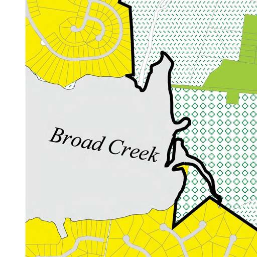

6 Map 5: Rural Tier Conceptual Land Use Plan 18 Approved Master Plan and SMA for Henson Creek-South Potomac
7 planned for suburban residential subdivision development that is more characteristic of the Developing Tier, not the Rural Tier. For these reasons, this plan amends the 2002 General Plan to reclassify the acre tract from the Rural Tier to the Developing Tier. Goals Maintain the historic rural character. Protect environmentally sensitive features and retain sustainable agricultural land. Protect scenic vistas along rural roadways. Protect property owners equity in their land. Implement the recommendations of the 2002 Broad Creek Historic District Preservation Planning Study. Encourage compatible design for development surrounding the Rural Tier. Conservation Subdivision Design is a flexible regulatory tool that allows for compact development to conserve scenic, historic, or environmental features. It is most frequently used in rural areas to preserve rural character. Policy 1: Design new development to retain and enhance rural character. STRATEGIES Enact conservation subdivision design regulations and other flexible design standards that place a premium on conserving open areas and protecting environmental features. Through this strategy, the approved residential lotting pattern may be more compact than typically allowed, but the land that is saved from development is much greater and better able to maintain connectivity with other open space areas. Ensure that land preserved during the development review process expresses one or more of the following values: Agricultural preservation Retention of scenic vistas Protection of areas within the designated green infrastructure network Create and implement rural design standards to ensure that new private and public development is consistent with the prevailing character of the rural area. The following guidelines should be incorporated into the standards: Houses should be set back a minimum of 100 feet from public rights-of-way to preserve scenic viewsheds, wooded areas, open fields, and ridge lines. The layout of the subdivision should preserve and enhance the existing natural features of the site including woodland, wetlands, streams, and areas of significant wildlife habitat. Utilize conservation subdivision principles to the extent possible. Preservation of existing vegetation or the installation of landscaping should be provided to soften and buffer views of houses and other structures. Landscape plants should be native and re-create rural buffers. Architecture should conform to the prevailing rural style, including such elements as rooflines and pitch, entrance drives, porches, lighting and building materials. Brick, stone and wood are encouraged building materials. Vinyl and aluminum siding are discouraged. Historic features such as fence rows, tree lines, and barns should be preserved. Fencing should be kept to a minimum to maintain open views and rural character. The use of stockade, board-on-board, chain-link, vinyl, and other high fences is discouraged. Fencing should respond to the rural character type, height and scale existing within the Rural Tier. Acceptable fencing includes stone walls, split rail, and equestrian style. Grading and drainage should be minimally intrusive. Massive cut and fill should be avoided. The creation of earth mounds, berms for screening, and platforms for house sites should be discouraged. Rural or scenic viewsheds along Livingston Road should be protected from adverse architectural or other development to maintain open and continuous views of the natural and agricultural landscape. Minimal impervious surfaces Reduction of forest fragmentation Minimal ecological impacts Approved Master Plan and SMA for Henson Creek-South Potomac 19
8 Policy 2: Retain or enhance environmentally sensitive features. STRATEGIES Minimize adverse impacts of development on sensitive environmental features such as streams, wetlands, floodplains and woodlands through implementation of the Green Infrastructure Plan. Protect forest interior dwelling species habitat in the Broad Creek watershed through the implementation of the Green Infrastructure Plan during the development review process. The sensitive wildlife habitat area located 300 feet inward from the edge of the forest. Revise the Woodland Conservation Ordinance to require that projects in the Rural Tier meet woodland conservation requirements on site. No off-site mitigation for woodland conservation should be allowed unless the site subject to the ordinance is substantially devoid of trees prior to development. Ensure that impacts to regulated areas are limited to unavoidable impacts, such as those for road crossings and utility easements. Consider carefully areas within designated evaluation areas in the green infrastructure network. Protect existing areas of connectivity of natural resources and enhance connections where they do not currently exist. Identify critical ecological systems supporting local and countywide special conservation areas during the land development review process. Ensure protection and enhancement of these systems. Encourage private property owners to convey land to M-NCPPC or a charitable trust in order to protect it from future development. Policy 3: Ensure that property owners surrounding the Rural Tier design new development or redevelopment to be compatible with the characteristics of the adjoining Rural Tier. STRATEGIES Require District Council review of development proposals adjacent to the Broad Creek Historic District for compatibility with the historic character of the area. Establish incentive programs such as tax incentives, transfer of development rights bonuses, grants, or favorable loans. Policy 4: Create visual gateways incorporating special elements and features to identify entrance points to the Rural Tier and to highlight its importance within the master plan area. STRATEGIES Provide a visual buffer using landscape materials and concepts to create a distinct edge along Old Fort Road that defines the boundary between the Henson Creek Transit Village and the Rural Tier and provides a transition from the higher density Transit Village to the low-density Rural Tier. Create gateways for the Rural Tier and the historic district at the intersections of Oxon Hill Road and Livingston Road, Livingston Road and Fort Washington Road, Oxon Hill Road and Henson Creek Stream Valley Park, and at trail access points into the Rural Tier. Policy 5: Ensure that public improvements preserve the character of the Rural Tier while improving access to and use of public facilities for community residents. STRATEGIES Preserve and enhance the historic and rural character of Livingston Road. Implement the recommendations of the Broad Creek Historic District Livingston Road Streetscape Guidelines and Alternatives study. Establish a publicly accessible equestrian center at Harmony Hall and an expanded equestrian trail system. Incorporate trail connections to facilitate pedestrian, biker and equestrian movement and to provide public access to the Potomac River waterfront and historic sites. Trail alignments and design should carefully consider the impacts of the trail on historically and archeologically significant properties. Policy 6: Protect landowners equity in their land. STRATEGIES Retain the existing land uses and density within the Rural Tier. Enact conservation subdivision design regulations and other flexible design standards. Encourage participation in a TDR program, pursuant to county legislation. 20 Approved Master Plan and SMA for Henson Creek-South Potomac
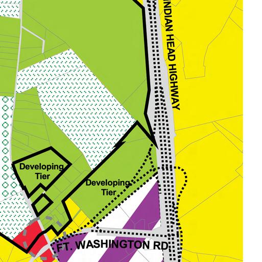
9 Developing Tier Vision The vision for the Developing Tier is a network of low-density residential communities and vibrant mixeduse commercial centers that feature a concentration of employment opportunities, quality stores, sit-down restaurants, public services, and amenities. Moderatedensity residential uses are concentrated within or near planned centers of mixed-use activity. The transportation system connects neighborhoods, parks, public facilities, and commercial centers by trails, sidewalks and transit, as well as by appropriately scaled roadways. Land uses in the Developing Tier enhance the historic character of the adjacent Rural Tier. Background The major portion of this master plan is located in the Developing Tier, which contains approximately 16,676 acres or 26 square miles. Much of this tier still features a semirural character established by a mixture of small- and large-lot subdivisions, small farms, garden plots, and woodlands. Multifamily projects are generally concentrated along Brinkley Road and MD 210. Nearly all of the multifamily projects in this tier were built in the 1960s and 1970s. More recently, multifamily development is taking place in the form of elderly housing projects. Many of the undeveloped properties in this tier have been approved for subdivision development that should occur in the foreseeable future. Nearly all are low-density, single-family subdivisions. The notable exception is National Harbor, which has been approved for approximately seven million square feet of commercial and entertainment development along the banks of the Potomac River at the Capital Beltway. The remaining tracts that have not been subdivided are generally small sites contained within established singlefamily residential neighborhoods. However, one large site located south of Brinkley Road is bordered by multifamily, commercial and institutional development as well as single-family neighborhoods. This 200-acre site presents a unique opportunity to develop a compact, high-quality, mixed-use planned neighborhood. It could also incorporate redevelopment of the adjoining racetrack property at some point in the future. Several large Class III landfills are located in this tier. Class III landfills are dumping sites that consist of difficult-tocompact soils, rocks and similar irreducible materials, which are not intended for future load-bearing use. While active, truck traffic through residential neighborhoods to get to these landfills has been an issue with area residents. Upon completion, Class III landfills are difficult to redevelop for other uses due to the composition of materials, steep slopes, and severe code limitations on construction of any type. Open space or very limited recreation activities may be the extent of future land uses on these sites. Commercial retail activity is focused in neighborhood shopping centers developed at four of the seven intersections along MD 210, at Rosecroft Village on Brinkley Road, and at Padgett s Corner in the Camp Springs community. All are typical, auto-oriented suburban centers anchored by grocery stores and local-serving retail businesses. As retail store sizes increased and trade areas expanded, competition for the same customers overlapped, and some shopping centers experienced high vacancies. The shopping centers along MD 210 at Fort Washington Road and on Brinkley Road near Fisher Drive have had vacant anchor stores for several years. The shopping center at Swan Creek Road was redeveloped in 2004 with a larger anchor store, but a reduced floor area overall. Small commercial uses are scattered throughout the neighborhoods along local roadways. A number of these are vacant, underutilized, or poorly maintained. Five multistory office buildings are located along MD 210 at Old Fort Road and Fort Washington Road in Fort Washington and along Oxon Hill Road in Fort Foote. The two office buildings in Fort Foote have been mostly vacant since they were built in the 1990s. The offices along MD 210 are continuously occupied. The Fort Washington Hospital adjacent to the shopping center at Swan Creek Road is a thriving health care complex that should provide a focal point for existing and new businesses in this area. Approved Master Plan and SMA for Henson Creek-South Potomac 21
10 To the north of the hospital, a large area has been zoned for industrial park development for over 20 years, but it has experienced little new development due in part to fragmented ownership patterns and the lack of a strong market for additional high-quality office or industrial park development. The main development challenges for the Developing Tier include: Reinforcing the character and quality of established residential neighborhoods. Ensuring that infill development in existing neighborhoods is compatible. Revitalizing older multifamily rental and condominium projects. Providing a variety of quality new housing types at appropriate locations. Improving the appearance and function of commercial areas. Attracting new, high-quality investment to reinforce commercial markets and shopping areas. Developing mixed-use, pedestrian-oriented environments that create a sense of place. The plan concept for future growth in the Developing Tier steers additional development and redevelopment toward the Metropolitan Center at National Harbor as part of the proposed Oxon Hill Road Transit Corridor, the planned community activity centers, or to existing neighborhoods as compatible infill development. This concept makes efficient use of existing and proposed public infrastructure and investment. The following section describes goals, policies and strategies for property within the Developing Tier. Due to the significance and complexity of the National Harbor Metropolitan Center, it is addressed in the Centers section of this plan. Goals Maintain low- to moderate-density land uses (except in centers and corridors). Reinforce existing suburban neighborhoods. Develop compact suburban residential neighborhoods. Reinforce planned commercial centers as community focal points. Develop compact, planned employment areas. Preserve and enhance environmentally sensitive areas. Policy 1: Preserve and enhance existing suburban residential neighborhoods. STRATEGIES Ensure that the design of new development in suburban residential areas maintains or enhances the character of the existing community. Retain low-density residential land use classifications for undeveloped parcels in established single-family residential neighborhoods. Encourage a wide variety of single-family designs and lot sizes. Design institutional or special exception uses to reflect the scale and character of the surrounding neighborhood. Encourage institutionally based development proposals with a mix of uses that focus on the institutional mission that may include high-quality residential, limited commercial, or community-oriented uses to provide a public benefit, to enhance community character, and are designed for compatibility with the surrounding neighborhood. Institutionally based development proposed should adhere to the following guidelines: Development should include pedestrian linkages to nearby commercial, institutional, or cultural uses. Development should be of sufficient size to provide amenities, such as indoor parking or garages, gardens, plazas, recreation facilities, or common eating areas. Development should have direct access to a collector road or greater to allow easy access for emergency services. Development should be served by public transit or shuttle buses to shopping and services in the surrounding area. Prior to approval of new development for senior citizen housing, a market analysis should be conducted that evaluates and satisfactorily demonstrates the need for senior housing within one mile of a proposed site. 22 Approved Master Plan and SMA for Henson Creek-South Potomac
11 Encourage renovation and beautification of moderate- to high-density multifamily apartment developments. Identify improvements to the physical environment that will enhance the visual appearance of apartment buildings and grounds and improve safety and security. Implement programs to improve the appearance, safety and security of high-density multifamily housing areas, including incentives for physical improvements, rehabilitation, more effective management, and code enforcement. Determine an appropriate balance or mix of rental and owner-occupied units. Design new development to create a continuous network of streets, sidewalks and trails to connect neighborhoods, open space, and major areas of activity. Policy 2: Encourage the development of compact, pedestrian-oriented residential communities on sites large enough to accommodate a mixture of housing types and sizes, recreation components, neighborhood-serving commercial amenities, and infrastructure. STRATEGY Prepare a detailed small area plan or development application for the undeveloped 200-acre area north of Rosecroft Raceway that conforms to best practices for compact community design and includes the following elements: A traditional neighborhood character with appropriately scaled and located neighborhood services. A mix of housing choices. Density and levels of intensity based on the capacity of transportation facilities or transit options servicing the area and compatibility with adjacent uses. Site plan orientation that focuses development toward a potential transit stop envisioned for the north part of the property as a feeder bus service or a potential future Metro light rail transit connection. An interconnected network of pedestrian-friendly streets, sidewalks and bikeways with multiple connections between new development, adjacent neighborhoods, and areas of activity. Extension of Barrowfield Road for additional access to the site from the adjacent residential neighborhood. An open space trail and pathway system with multiple connections between new development and adjacent parks and open spaces. Additional public parkland needed to serve this area. Accommodating recommendations of the Green Infrastructure Plan for the evaluation area located along the west side of the tract. Defining the relationship to Rosecroft Raceway as an ongoing commercial entertainment venue or, alternatively, considering redevelopment of Rosecroft as an integral part of the proposal. Policy 3: Renew or replace declining retail and commercial areas with compatible, economically viable land uses. STRATEGIES Allow a mix of commercial or residential uses to replace or supplement underutilized business areas. Implement improvements to the physical environment that will enhance the visual appearance of commercial areas and improve access for customers. Provide incentives to upgrade facilities that have proven market feasibility. Give priority to property and business owners that improve the retail or commercial space for an alternative economically-viable use. Design new or restored uses for compatibility with the surrounding neighborhood. Policy 4: Implement new patterns of development that preserve and enhance the environmental features and green infrastructure elements of the area. STRATEGIES Preserve the existing environmental infrastructure and resources, including forests, open spaces, and sensitive habitats, that surround development sites located throughout the Developing Tier. Sustainable Design: Development that is sensitive to issues of energy efficiency, recycling and conservation of materials and resources, waste reduction, and environmentally sensitive design. The goal of sustainable development is to meet current needs of potential users without compromising the ability of future generations to meet their own needs. Approved Master Plan and SMA for Henson Creek-South Potomac 23
12 Limit development in environmentally sensitive areas. Encourage sustainable design as part of the development review process. Cluster new residential development to the greatest extent possible to minimize forest fragmentation and mitigate environmental impacts. Reclaim impervious areas in developed areas. Implement the recommendations of the Green Infrastructure Plan. Create new open space and pedestrian trail connections. Institute an urban forestry/replanting program in developed areas, including street trees and urban parks, connected to the larger pattern of green infrastructure. Require sidewalks and bicycle facilities as part of development and along all new roadways. Policy 5: Reinforce and enhance the character of the adjoining Rural Tier and the Broad Creek Historic District. STRATEGIES Encourage new development surrounding the Rural Tier to voluntarily incorporate designs and materials that are consistent with guidelines in the 2002 Broad Creek Historic District Preservation Planning Study. Enact a countywide transfer of development rights (TDR) program that designates mixed-use areas and residential areas in the Developing Tier as potential TDR receiving areas from the Rural Tier and historic districts. Limit the number of TDRs transferred to low-density residential sites to a small percentage over allowed density to maintain neighborhood character. Revise regulations to provide greater design flexibility for single-family residential subdivisions receiving TDRs to ensure good site design and compatibility with the neighboring community. Policy 6: Reinforce the economic viability of planned activity centers in the Developing Tier. STRATEGIES Reduce the number of commercial areas competing for similar markets by focusing community-oriented commercial and mixed-use development to a limited number of locations within the Developing Tier, such as Henson Creek and Broad Creek Transit Villages off MD 210 and Padgett s Corner at the intersection of Allentown Road and Temple Hill Road. Promote a mixture of commercial and residential uses within and around activity centers that reinforce the center, contribute to a sense of place, include pedestrian-oriented design and crime prevention through environmental design (see the Urban Design Section), and provide a compatible transition between existing commercial uses and surrounding low-density neighborhoods. Exclude big-box retail uses in order to redevelop the planned community commercial activity centers as pedestrian-friendly environments with a village-scale character. Focus planned mixed-use activity center development primarily to one side of Indian Head Highway (MD 210) between closely spaced interchanges to afford better circulation and transit access, as well as compact, mixed-use, pedestrian-oriented development. Implement multimodal transportation concepts to serve transit-friendly and pedestrian-oriented development patterns. Consider MD 210 and MD 5 as a future route for bus rapid transit (BRT) with appropriate land uses and development patterns located at the activity centers in a manner that encourages the increased use of express bus service in the corridor. Improve transportation facilities in a manner that minimizes land use conflicts but provides adequate pedestrian and vehicular access. Prepare detailed small area redevelopment plans for each commercial activity center as part of a coordinated redevelopment program, including public/private partnerships and the local community, to improve their character and economic viability. Implement appropriate standards and guidelines to ensure that future development is characterized by highquality, mixed-use development that conforms to best practices for pedestrian- and transit-oriented design. Consider use of a Development District Overlay Zone, a form-based code (FBC), or appropriate mixed-use zones to achieve the desired small village character. Evaluate private rezoning and development applications in accordance with development concepts and guidelines of this master plan for each planned activity center. Consider revising the Zoning Ordinance to allow development of townhouse-style dwelling units in planned activity centers with a design concept that is characteristic of urban development in towns and cities. 24 Approved Master Plan and SMA for Henson Creek-South Potomac


13 Mixed-Use Activity Centers The Henson Creek-South Potomac master plan designates three areas in the Developing Tier as mixed-use activity centers. These are specific locations where a pedestrianoriented mix of residential, commercial, retail, office, civic, recreation, and open space land uses should be encouraged. Each mixed-use activity center features a unique development concept, and the master plan identifies strategies and guidelines to achieve the concepts. The three mixed-use activity centers in the Developing Tier are the Henson Creek Transit Village, the Broad Creek Transit Village and Medical Park, and Padgett s Corner. Map 6: Mixed-Use Activity Centers Approved Master Plan and SMA for Henson Creek-South Potomac 25
14 Henson Creek Transit Village The Henson Creek existing land use is shown on Map 7. The Henson Creek Transit Village is envisioned as a pedestrianoriented village setting focused on a two- to three-block section of Livingston Road between Palmer Road and Old Fort Road. The master plan proposes redevelopment of the existing commercial buildings to create a main street (see Map 9) setting that will orient the majority of pedestrian activity along Livingston Road. The addition of moderatedensity residential development along a grid pattern of new streets is proposed along the edges of the village, as is a vertical mix of residential and commercial uses along the main street. A transit station will be strategically located near Indian Head Highway to provide express bus or future bus rapid transit service for village residents and workers, as well as surrounding communities. Guidelines Implement a future street grid pattern that supports low-scale, pedestrian-friendly redevelopment with a village character. Land use and urban design features for subareas of the village center (see Map 8): Area A New buildings should be predominantly one- to two-story structures compatible with surrounding neighborhood uses and should front onto Livingston Road. Wide, tree-lined sidewalks should define the street and contribute to a main street character. Parking areas should be located to the rear of buildings. A transit station stop should be strategically located to serve existing express bus or potential bus rapid transit (BRT) service along Indian Head Highway. Livingston Road should be reconfigured to create a focal point at the center of the new village environment, with on-street parking and traffic calming features to support pedestrian circulation. A pedestrian pathway and linear green space system should connect the Henson Creek Transit Village to the Henson Creek trail system. New development should be designed with an architectural character that reflects the village center s role as a gateway to the Rural Tier and the Broad Creek Historic District. Consider the possibility of additional retail commercial development on property located at the southwest corner of MD 210 and Old Fort Road North (known as the Kaydot property) through the filing of a rezoning application that is sensitive to architectural techniques that are compatible with the adjoining historic district. Area B Low intensity live/work and senior living residential opportunities should be located at the western and southern edge of the village to visually buffer surrounding areas and to provide a low-scale residential edge to the area that faces onto the Rural Tier. A planted landscape/wooded buffer should line Oxon Hill Road to provide a visual buffer between the transit village and the Rural Tier that reflects a more natural appearance. 26 Approved Master Plan and SMA for Henson Creek-South Potomac

15 Map 7: Henson Creek Existing Land Use Approved Master Plan and SMA for Henson Creek-South Potomac 27

16 Map 8: Henson Creek Transit Village Proposed Land Use Note: This illustration portrays a long-range redevelopment scenario that may result from implementation of recommended land use concepts for the Henson Creek Transit Village area. It is likely that variations will occur as redevelopment takes place that also conform to the planning principles and concepts recommended for revitalization of this area. 28 Approved Master Plan and SMA for Henson Creek-South Potomac

17 Map 9: Henson Creek Street Pattern Note: This illustration portrays a long-range redevelopment scenario that may result from implementation of recommended land use concepts for the Henson Creek Transit Village area. It is likely that variations will occur as redevelopment takes place that also conform to the planning principles and concepts recommended for revitalization of this area. Approved Master Plan and SMA for Henson Creek-South Potomac 29
18 Broad Creek Transit Village and Medical Park The Broad Creek Transit Village and Medical Park existing land use is shown on Map 10. The Broad Creek Transit Village and Medical Park is envisioned to allow a low-scale mix of uses that capitalize on proximity to, and potential expansion of, the Fort Washington Hospital, such as medical offices, outpatient and health care uses, and possibly a senior living/elderly housing complex. A pedestrian-friendly development pattern with a street grid of short blocks and an internal main street creates a new identity and focal point for development in the area between Livingston Road and Indian Head Highway. The new development pattern (see Maps 11 and 12) is intended to link existing commercial land uses within the activity center area with a new, economically-viable and more marketable development theme. A transit station will be strategically located near Indian Head Highway to provide express bus or future bus rapid transit service for village residents and workers, as well as surrounding communities. Guidelines Implement a new street pattern focused on a new main street with wide, tree-lined sidewalks, new buildings facing the streets, and parking areas located to the rear of buildings. Consider potential expansion of the Fort Washington Hospital or creation of a related medical park for outpatient services and support. Phase redevelopment of existing industrial uses located along Indian Head Highway as mixed-use use development opportunity sites in support of the Broad Creek Transit Village and Medical Park concept. Investigate the feasibility of a substantial senior living complex as an integral part of the transit village and medical park development concept. A viable senior complex should include high-quality construction and an amenity package tailored to meet the needs of the resident population. Locate a transit station stop at the north end of the transit village, near the proposed police station/public facility site, to serve express bus and potentially BRT along Indian Head Highway. 30 Approved Master Plan and SMA for Henson Creek-South Potomac

19 Map 10: Broad Creek Transit Village and Medical Park Existing Land Use Approved Master Plan and SMA for Henson Creek-South Potomac 31


20 Map 11: Broad Creek Transit Village and Medical Park Land Use and Development Pattern Note: This illustration portrays a long-range redevelopment scenario that may result from implementation of recommended land use concepts for the Broad Creek Transit Village and Medical Park area. It is likely that variations will occur as redevelopment takes place that also conform to the planning principles and concepts recommended for revitalization of this area. 32 Approved Master Plan and SMA for Henson Creek-South Potomac
21 Map 12: Broad Creek Transit Village and Medical Park Street Pattern Note: This illustration portrays a long-range redevelopment scenario that may result from implementation of recommended land use concepts for the Broad Creek Transit Village and Medical Park area. It is likely that variations will occur as redevelopment takes place that also conform to the planning principles and concepts recommended for revitalization of this area. Approved Master Plan and SMA for Henson Creek-South Potomac 33

22 Padgett s Corner Activity Center The Padgett s Corner Activity Center is envisioned as a community-scale commercial area that supports the surrounding residential neighborhoods by providing locally serving retail, office and public uses closely integrated with residential development. Guidelines Reinforce the Padgett s Corner area as the focal point for local commercial land use in the eastern part of the Developing Tier by allowing a mix of residential and pedestrian-oriented commercial redevelopment. Implement a pedestrian circulation plan for the activity center that links all four quadrants of the intersection of Temple Hill Road and Allentown Road with safe highway crosswalks and provides connections to adjacent residential properties and neighborhoods. Consider moderate-density housing proposals within or adjacent to this activity center that are designed as an integral part of the activity center and provide transition between commercial land uses and established singlefamily residential development. Map 13: Padgett s Corner Existing Land Use 34 Approved Master Plan and SMA for Henson Creek-South Potomac
23 Developed Tier Vision The vision for the Developed Tier is a network of sustainable, transit-supporting, mixed-use, pedestrian-oriented, low-, medium-, and high-density neighborhoods with upscale retail and safe pedestrian and vehicular routes that connect the neighborhoods and centers in a way that will bring the area more closely together. Background The northern portion of this master plan area is located in the Developed Tier. The Developed Tier contains approximately 3,468 acres or 5.4 square miles. Small-lot, single-family residential subdivisions and apartment projects, largely built during the 1950s to the 1960s, establish the development pattern for the majority of the land area in this tier. Approximately one-half of the dwelling units in this tier are apartments or condominiums; more than half of those were built in the 1960s. The majority of apartment projects are concentrated along Brinkley Road in the central part of the tier. Additional apartments are at scattered locations along Oxon Hill Road, Livingston Road, or Allentown Road. Commercial land uses are concentrated at the eastern and western parts of the tier, along Allentown Road and Oxon Hill Road, respectively. These commercial areas include some of the original strip shopping centers and big-box retail stores that accompanied suburban residential expansion in the 1960s. The Oxon Hill Road commercial area evolved into a suburban downtown consisting of a one-and-onehalf mile-long corridor of shopping centers, multistory office buildings, and freestanding businesses. A similar pattern of strip commercial uses evolved along Allentown Road east and west of MD 5. As retail markets changed and newer centers or bigger stores were built in competing locations, retail uses in this tier declined. A number of former retail business have been converted to nonretail uses or are underutilized. Most of the development in this tier occurred prior to the development of the design standards and strict environmental regulations that are in effect today. Thus, on-site stormwater management facilities, landscaping, tree cover, contiguous natural areas, trails, and recreation areas are limited. There are extensive areas of paving and impervious surfaces. Few large, undeveloped tracts remain. Therefore, the new development will primarily be the redevelopment or revitalization of existing commercial and residential uses or infill on smaller, undeveloped tracts within established neighborhoods. The main challenges for the Developed Tier are: Reinforcing the character and quality of established residential neighborhoods. Ensuring that infill development in existing neighborhoods is compatible. Revitalizing older multifamily rental and condominium projects and areas. Improving the appearance and function of commercial areas. Attracting new, high-quality investment. Restoring the natural features and processes. The plan concept makes efficient use of existing and proposed public infrastructure and investment by steering the bulk of new development toward the regional center at Oxon Hill, the Corridor Node at MD 5 and Allentown Road, and the commercial areas across from Andrews Air Force Base. Due to the significance and complexity of the Oxon Hill Regional Center, it is addressed in a separate section of this plan. Goals Strengthen existing neighborhoods. Encourage appropriate infill. Encourage more intense, high-quality housing and economic development in centers and corridor nodes. Preserve, restore and enhance natural features and provide open space. Expand tree cover through increased planting of trees and landscaping. Approved Master Plan and SMA for Henson Creek-South Potomac 35
24 Promote transit-supporting, mixed-use, pedestrianoriented neighborhoods. Require pedestrian-oriented and transit-oriented design. Renew/redevelop commercial strips. Ensure compatibility with surrounding neighborhoods. Policy 1: Preserve and enhance existing suburban residential neighborhoods. STRATEGIES Ensure that the design of new development in suburban residential areas maintains or enhances the character of the existing community. Retain low-density residential land use classifications for undeveloped parcels in established single-family residential neighborhoods. Design institutional or special exception uses to reflect the scale and character of the surrounding neighborhood. Enhance existing multifamily apartment developments. * Identify improvements to the physical environment that will enhance the visual appearance of apartment buildings and grounds and improve safety and security. * Implement programs to improve appearance, safety and security in high-density multifamily housing areas, including incentives for physical improvements, rehabilitation, more effective management, and code enforcement. Encourage institutionally based development proposals that may include a mix of high-quality senior citizen housing, limited commercial, or community-oriented uses, that focus on the institutional mission, provide a public benefit, enhance community character, and are designed for compatibility with the surrounding neighborhood. Institutionally based development proposals should adhere to the following guidelines: Development should include pedestrian linkages to nearby commercial, institutional, or cultural uses. Development should be of sufficient size to provide amenities, such as indoor parking or garages, gardens, plazas, recreation facilities, or common eating areas. Development should have direct access to a collector road or greater to allow easy access for emergency services. Development should be served by public transit or shuttle buses to shopping and services in the surrounding area. Prior to approval of new development for senior citizen housing, a market analysis should be conducted that evaluates and satisfactorily demonstrates the need for senior housing within one mile of a proposed site. Create new open space and pedestrian trail connections. Design new subdivisions and developments to create a continuous network of streets, sidewalks and trails to connect neighborhoods and major areas of activity. Perform code enforcement and provide housing rehabilitation assistance in older subdivisions to encourage continuous maintenance of structures and to prevent housing or neighborhood deterioration. Policy 2: Improve the image and mix of uses along major roadways not designated as General Plan Corridors. STRATEGIES North side of Allentown Road across from Andrews Air Force Base (AAFB) (Map 14) Prepare a revitalization plan (or private redevelopment proposal as a rezoning application) that promotes a new identity and sense of place as the Gateway to Andrews Air Force Base. Promote a balanced mix of new or revitalized commercial and residential land uses, including senior housing designed according to best practices, for compact, mixeduse, pedestrian-oriented design principles. Include specific urban design elements for the AAFB Gateway. * New buildings facing onto wide, tree-lined sidewalks along Allentown Road. * Surface parking lots located to the rear of buildings. * A new street and sidewalk grid to connect Allentown Road to adjacent residential areas, enhance pedestrian circulation, improve access to bus stops, and reduce traffic conflicts. * Live/work or elderly housing located in edge areas that face onto existing residential neighborhoods. * Streetscape and public art elements that create a sense of arrival or departure from the area. 36 Approved Master Plan and SMA for Henson Creek-South Potomac

25 Map 14: Andrews Manor Existing Land Use Approved Master Plan and SMA for Henson Creek-South Potomac 37
26 Policy 3: Renew or replace declining small retail and commercial areas with more economically viable land uses. STRATEGIES Allow a mix of commercial or residential uses to replace or supplement underutilized business areas. Implement improvements to the physical environment that enhance the visual appearance of commercial areas and improve access for customers. Provide incentives to upgrade facilities that have proven market feasibility. Give priority to property and business owners who improve retail or commercial space for an alternative economically viable use. Design new or restored uses for compatibility with the surrounding neighborhood. Policy 4: Apply land use regulations and revitalization programs that promote redevelopment and revitalization. STRATEGIES Prepare streamlined zoning techniques, standards and guidelines that Provide flexibility for an appropriate mix of commercial or residential land use types. Ensure high-quality design consistent with best practices for pedestrian- and transit-oriented design principles. Revise zoning patterns through Preparation of a detailed small area plan or revitalization program that includes a mixed-use Development District Overlay Zone (DDOZ), form-based code, or other appropriate mixed-use zones. Implementation of a revitalization overlay zone that streamlines development regulations and focus public resources on implementing projects consistent with master plan concepts and design guidelines. Review according to the land use and design principles of this plan of rezoning applications for an appropriate mixed-use zone. Policy 5: Preserve, restore and enhance environmental features and green infrastructure elements. STRATEGIES Extend the Henson Creek trail and park. Design new residential development to maximize contiguous woodland and tree cover. Encourage sustainable design as part of the redevelopment and development review process. Reclaim impervious surfaces in developed areas by retrofitting low impact development techniques in redevelopment projects. Institute an urban forestry/replanting program in developed areas, including street trees and urban parks, connected to the larger pattern of green infrastructure. Policy 6: Encourage medium-density, mixed-use, transitand pedestrian-oriented development at the Branch Avenue/Allentown Road General Plan Corridor Node. (Maps 15-18A/B) STRATEGIES Prepare detailed revitalization plans (or private redevelopment proposals as rezoning applications) to improve the character and economic vitality of development on each side of the Branch Avenue/ Allentown Road Corridor Node. Require urban design that promotes small-scale, pedestrian-oriented, mixed-use redevelopment consistent with the best practices. Design a compatible mix of land uses that account for the barrier posed by the Branch Avenue freeway interchange to a comprehensive, integrated development pattern. East Side of Branch Avenue (MD 5) North of Allentown Road Design a mix of low- to moderate-density residential land uses with higher density housing located along the Branch Avenue frontage and lower densities along the boundaries of existing neighborhoods. 38 Approved Master Plan and SMA for Henson Creek-South Potomac
27 Map 15: Camp Springs Town Center Area Approved Master Plan and SMA for Henson Creek-South Potomac 39

28 Map 16: Camp Springs Town Center Existing Land Use 40 Approved Master Plan and SMA for Henson Creek-South Potomac

29 Map 17: Illustration of Land Use Concepts for the Camp Springs Town Center Arts District Note: Maps 17, 18a, and 18b portray a long-range redevelopment scenario that may result from implementation of recommended land use concepts for the Camp Springs Town Center Arts District area. It is likely that variations will occur as redevelopment takes place that also conform to the planning principles and concepts recommended for revitalization of this area. Approved Master Plan and SMA for Henson Creek-South Potomac 41

30 Map 18A: Street Pattern for the Camp Springs Town Center Arts District 42 Approved Master Plan and SMA for Henson Creek-South Potomac
31 Map 18B: Pedestrian Circulation for the Camp Springs Town Center Arts District Approved Master Plan and SMA for Henson Creek-South Potomac 43


32 Section of Allentown Road as Boulevard Section of Allentown Way as Main Street 44 Approved Master Plan and SMA for Henson Creek-South Potomac
33 Create a local street circulation pattern that provides multiple connections between neighborhoods and new projects to improve both pedestrian and vehicular accessibility. Encourage assembly of fragmented, small- and largelot ownership patterns into more comprehensive development proposals. Provide local park and recreation facilities. South of Allentown Road Develop a low-intensity mix of commercial or institutional uses that improves the visual character, economic vitality and accessibility. West Side of Branch Avenue (MD 5) Design a mix of commercial and residential uses that establishes a new identity and sense of place as the Camp Springs Village Center, which includes: A core area defined by properties fronting on the triangle formed by Allentown Road, Old Branch Avenue, and Allentown Way that incorporates primarily two- to three-story buildings with a vertical and horizontal mix of uses; taller buildings may be appropriate at strategic locations, such as at major intersections or adjacent to MD 5. Edge areas adjacent to the core area that are predominantly residential and incorporate a mix of town homes, live/work units, small-lot single-family and senior living opportunities, and small businesses where appropriate. Provide public facilities at strategic locations to create a revitalized center of activity. A public park designed as the major focal point for gatherings, festivals and performances at a prominent location within the core area. Public art elements to create an art-filled environment that will enhance the town center s unique sense of place. Provide a new street and sidewalk grid to create a more pedestrian-friendly environment and improve vehicular access. Reconfigure Allentown Road between MD 5 and Brinkley Road as a six-lane arterial road with a main street character including a landscaped median and crosswalks at certain intervals to relieve congestion. Reinforce the design of Allentown Way as a pedestrianfriendly, tree-lined, commercial main street with wide sidewalks and on-street parking. Encourage commercial lot assembly and elimination of curb cuts to provide safer pedestrian access across the fronts of buildings and smoother traffic flow along Allentown Road and Old Branch Avenue. Provide wide planting zones between the curb and new sidewalks as a pedestrian safety zone that encourages window shopping for ground floor retail. Distribute structured parking to replace surface parking lots as new development creates an increased demand for parking. Locate any surface parking to the rear or on the side of buildings. Promote new land uses that provide a catalyst for economic development and revitalization. Evaluate the potential for incorporating art, entertainment, or specialty retail uses. Prepare a market feasibility analysis to ascertain the potential for creating and maintaining a new performing and visual arts center. Review development applications in the Camp Springs Town Center area for consistency with any subsequent planning study prepared by the Planning Board or a Prince George s County government agency which provides more detailed guidelines or recommendations for redevelopment or revitalization, such as the Camp Springs (Henson Creek-South Potomac) Arts District Planning Study. Approved Master Plan and SMA for Henson Creek-South Potomac 45
34 46 Approved Master Plan and SMA for Henson Creek-South Potomac


35 Centers and Corridors Vision The vision for centers and corridors is mixed residential and nonresidential uses at moderate to high densities and intensities, with a strong emphasis on a transit-oriented, pedestrian-friendly, live/work/play environment that has an urban feel. Background The General Plan identifies two centers in the Henson Creek-South Potomac planning area: National Harbor and Oxon Hill. The National Harbor Center is an approved development project for a major mixed-use commercial and entertainment venue of metropolitan significance. Upon completion, the approved development plan will yield more than seven million square feet of commercial, entertainment and hotel development along the banks of the Potomac River. The groundbreaking for the initial phase of the project, a convention center, occurred in December Diversifying the mix of uses in the National Harbor project to include a residential component has been raised as an issue during the preparation of this master plan. The areas across the country, some of their markets have been captured by newer or more distant shopping areas only accessible by automobile. Underutilization, vacancies, poor maintenance, and decline have often been the result (see Map 19). However, a recent revitalization at Rivertowne Commons has brought new tenants and new life to a declining shopping center. It is anticipated that the economic stimulus provided by new development at National Harbor will further transform the market in this part of the county, providing the incentive for redevelopment in Oxon Hill. View of Rivertowne Commons and vicinity. Illustration of proposed convention center at National Harbor. Oxon Hill Regional Center is the suburban downtown for this part of the county. Strip-commercial shopping centers, big-box stores, and offices characterize the area, along with highway-oriented service commercial uses that evolved with suburban expansion. As with many older commercial At the present time, regional transit planning locates both National Harbor and Oxon Hill on a proposed rail transit line, known as the Purple Line, crossing the Woodrow Wilson Bridge from Virginia and extending to the Branch Avenue Metro Station and points north. Another transit extension from Anacostia in the District of Columbia south to the Beltway and National Harbor is under study. At the current stage of transit planning, it is unknown whether the future rail lines will be light-rail (surface, on-street access) or heavy-rail (generally underground or elevated access). Regardless, the introduction of transit in the future will result in, and focus development interests on, two to four potential locations for transit stations. The proximity of the future station sites and their walk-sheds combine to mutually reinforce evolving market niches and redevelopment opportunities similar to what has taken place Approved Master Plan and SMA for Henson Creek-South Potomac 47

36 Map 19: Oxon Hill Regional Center Existing Land Use 48 Approved Master Plan and SMA for Henson Creek-South Potomac

37 Potential light rail transit alignment and station stop for the Henson Creek/South Potomac development corridor. along the Rosslyn/Ballston corridor on the Metro Orange Line in Virginia. Due to their prominent locations along the Potomac River at the Capital Beltway and I-95, and with the anticipation of new transit facilities, the National Harbor and Oxon Hill centers have the potential to grow and intensify as a mixeduse, transit-oriented corridor, with residential, commercial, office and recreational development complemented by open spaces such as public plazas and parks. This plan recognizes that to achieve the desired vision, the types of uses, density, intensity and character will need to evolve over time and will require public-private investment and partnerships. As a new development site, National Harbor will lead the way. Development within the Oxon Hill Center will largely require redevelopment of existing uses or infill and is not likely to experience dramatic results in the short- to midterm (less than ten years). Regardless, infill and small-scale redevelopment of existing areas and quality place-making should occur in the short term, thus setting the stage for more intensive uses to follow as market demand increases, older under-developed private facilities are fully amortized, and new road patterns and transit facilities are provided. To reinforce this concept, this plan amends the 2002 General Plan to classify the segment of the proposed Purple Line transit corridor between the Woodrow Wilson Bridge and Brinkley Road as a General Plan corridor and a priority for future development planning and assistance in the county. Master plan recommendations for the other General Plan Corridor Node along MD 5 at Allentown Road are contained in the chapter on the Developed Tier, where it is located. Goals Promote compact, mixed-use development at moderate to high densities. Encourage high-quality infill and redevelopment of existing commercial and parking areas, over time. Ensure transit-supportive and transit-serviceable development and promote transit opportunities. Require pedestrian-oriented and transit-oriented design. Provide necessary transportation and public facility improvements to support the plan. Provide a new grid pattern of walkable, interconnected streets and blocks. Policy 1: Promote development of mixed residential and nonresidential uses at high densities and intensities at the National Harbor Metropolitan Center in the Oxon Hill Transit Corridor with a strong emphasis on pedestrianand transit-oriented development. STRATEGY Develop the National Harbor Metropolitan Center as a high-intensity, mixed-use waterfront center that creates a new identity and image for this area. Emphasize mixed-use and transit-oriented development patterns in the vicinity of the recommended transit station(s). Pedestrian-Oriented Design: Development that is designed and arranged in a way that emphasizes travel on foot rather than by car. Elements include compact, mixed-use development patterns with facilities and design that enhance the environment for pedestrians in terms of safety, walking distances, comfort, and the visual appeal of the surroundings. Transit-Oriented Development (TOD): A type of development that consists of mixed-use communities within a close proximity to a transit station or stop, typically within approximately a ten-minute walking radius. TOD mixes residential, retail, office, and public uses (public buildings, parks, plazas, or other open spaces) in a medium- to high-density, walkable environment by making it convenient for residents, shoppers and employees to travel by transit, bicycle, foot or car. Approved Master Plan and SMA for Henson Creek-South Potomac 49


38 National Harbor Development Concept Map 20: Oxon Hill Regional Center Vision Diagram 50 Approved Master Plan and SMA for Henson Creek-South Potomac


39 Map 21: Oxon Hill Street Pattern Consider the addition of a high-density residential component at an appropriate location within the waterfront center to complement the approved high intensity commercial and entertainment land uses. Design future land uses surrounding the waterfront center to complement its distinctive character, to be compatible with the neighboring community, and to provide a suitable gateway to this unique project. Policy 2: Promote development of mixed residential and nonresidential uses at moderate to high densities and intensities at the Oxon Hill Regional Center and in the Oxon Hill Transit Corridor with a strong emphasis on pedestrian- and transit-oriented development. STRATEGY Redevelop the Oxon Hill area as a major center of regional activity with a moderate- to high-intensity mix of residential and nonresidential uses organized to create an urban character and feel. Evaluate all development proposals for compliance with best practices for transit-oriented development and with the following design guidelines to establish the desired character within the Oxon Hill Center. Urban-scale buildings and a pedestrian-friendly development pattern to produce the desired character and economic growth anticipated for the area. A new street and block pattern to allow for the efficient movement of pedestrians, bicycles and vehicles, including: * A hierarchy of major and minor streets, cross-streets, and sidewalks that link the area together in both an east-west and north-south direction with surrounding neighborhoods. * Short block patterns that allow for multiple interconnections and pedestrian pathway intersections, generally no further than 400 feet apart. * A new arterial roadway to relieve traffic congestion on Oxon Hill Road. * Oxon Hill Road reconfigured as an arterial road with a grand boulevard design from St. Barnabas Road to Indian Head Highway that includes four drive lanes, curbside parking, wide sidewalks and a wide center island designed to accommodate a potential future Light Rail Transit (LRT) alignment and station stops. * A central park roadway crossing the transit grand boulevard to create an organizing spine and front door roadway to the core area. * A new transit station stop located on the median strip of the proposed Oxon Hill Boulevard at the intersection of the proposed central park. Approved Master Plan and SMA for Henson Creek-South Potomac 51

40 Map 22: Oxon Hill Land Use Note: This illustration portrays a long-range redevelopment scenario that may result from implementation of recommended land use concepts for Oxon Hill. It is likely that variations will occur as redevelopment takes place that also conform to the planning principles and concepts recommended for revitalization of this area. 52 Approved Master Plan and SMA for Henson Creek-South Potomac


41 Define boundaries and land use concepts for the center s core and edge areas to ensure that the most intensive development occurs in close proximity to and is supportive of a mass transit facility. The recommended boundaries of the Oxon Hill Regional Center development areas are shown on Map 23, page 55. The key development concepts for each area are: Area A defines the core area of the Oxon Hill Regional Center to incorporate a mix of uses that allow for urban and transit-oriented development level densities and intensities within a walkable, human-scale urban setting. Development guidelines include the following elements: Building Height * Maximum height of ten stories. * Towers may extend 25 feet above the roof line. Setbacks * Zero lot line front yards. Buildings should be constructed up to the build-to line located at the edge of the sidewalk. * Allow ground floor façade setbacks for colonnades and expanded outdoor seating areas or cafés. * Graduate façade setbacks for tall buildings to ensure a pedestrian-scale streetscape, such as a setback of 15 feet above 40 feet height and an additional 10 feet above 65 feet. Building Façades * The ground floor façade should be predominantly transparent display windows that allow pedestrian window-shopping. * Blank, nontransparent street level walls should be strongly discouraged. Uses * Retail should be the predominant use at the sidewalk level. Walk-in businesses and shops with open, transparent street façades should be encouraged. * Locate residential uses above street-level retail with a rich mix of office uses distributed throughout the area. * Half basement, below-grade structures should be strongly discouraged. Sidewalks * Along primary streets, sidewalks should be 15- to 20-feet wide to allow for tree planting, a pedestrian travel area, and an amenity area for outdoor seating or cafés. Graduated façade setbacks. Area A sidewalks along primary streets. Approved Master Plan and SMA for Henson Creek-South Potomac 53

42 Parking * Parking structures should be strategically located to reduce walking distances. * In general, parking structures facing onto primary and secondary streets should incorporate a nonparking use at the sidewalk level that wraps the parking structure to create a pedestrian-friendly character or image. Area B defines the eastern edge of the center area, which should incorporate predominantly office uses with a maximum building height of up to eight floors. All other development requirements are similar to the core area. Area C defines the western and southern edges of the center area and should incorporate predominantly moderate-density, multifamily apartments and townhouses. Development guidelines include the following elements: Building Height * Maximum height of four stories. Setbacks * Buildings should generally be built up to the sidewalk. * Some buildings may have setback of up to 25 feet for a front yard to create a varied streetscape image and a variety of building forms. Uses * Townhouses and moderate-density multifamily apartments. * Small neighborhood service-retail should be allowed at strategic corner locations. * Single-family detached residential development should be strongly discouraged. Sidewalks * Along primary streets, sidewalks should be 15 feet wide to incorporate a planting zone for street trees and tree grates and wide, pedestrian travel area. Area C sidewalks along primary streets. Area D defines two edge locations just beyond the center walk-shed at the St. Barnabas Road exit from I-495/I-95 and the area along Livingston Road that are characterized by large-lot, auto-oriented, retail and big-box uses. Structures of one to two stories are envisioned, with surface parking lots located to the rear of buildings. Buildings should be encouraged to face toward major streets. Area E defines two transition areas located between the Oxon Hill Regional Center and the Indian Head Highway exit from I-495 to the west and the entrance to Rosecroft Raceway on Brinkley Road to the east. Educational facilities are encouraged in Area E west of the center. Area E may be designated for future development at lower scale TOD densities and intensities than proposed for the core area in order to serve potential future LRT station stops. 54 Approved Master Plan and SMA for Henson Creek-South Potomac


43 Map 23: Oxon Hill Regional Center Open Space and Greenway Concept Plan Note: This illustration portrays a long-range redevelopment scenario that may result from implementation of recommended land use concepts for the Camp Springs Town Center Arts District area. It is likely that variations will occur as redevelopment takes place that also conform to the planning principles and concepts recommended for revitalization of this area. Locate urban-scale parks, small parks, landscaping, and public art throughout the Oxon Hill Regional Center. * Central Park A major urban park that creates a north-south spine to connect the core area in the north to the residential area in the south. The park serves as the central gathering place in the Oxon Hill Regional Center for formal and informal public events. View of Central Park gateway to the core area and stepback design of buildings to create a pedestrian-scale character. * Oxon Hill Boulevard The primary pedestrian promenade and high-end retail street that connects the area in an east-west direction. The boulevard may be designed to create a critical mass of activity and intensity of development at the intersection of central park, the location of a future LRT stop. Blocks along the boulevard to the east and west of the central park should be developed at a less intense level in order to focus pedestrian activity at the primary intersection. * Small urban parks located at key points along major streets such as at either end of the proposed Oxon Hill Boulevard. * Bus stop landscaping and shelters Bus stop locations should be incorporated within streetscape guidelines to allow for greater access and bus rider enjoyment. * Pedestrian-scale streetscape design Vest pocket parks and wide sidewalk sitting areas and cafés should be incorporated at strategic pedestrian crosspaths throughout the core and edge areas. Approved Master Plan and SMA for Henson Creek-South Potomac 55
44 * Rooftop gardens and green areas Rooftop areas and green roof technologies should be encouraged and incorporated throughout the core and edge areas. Locate public use facilities in the Oxon Hill Regional Center to support and enhance the area s public purpose and use. * Retain and enhance the Oxon Hill Public Library as a cornerstone for the public use of the area. Create a new entrance plaza facing Oxon Hill Road and redesign landscaping and access to the facility to allow for public assembly and activities. * Investigate the potential for moving the Oxon Hill Post Office to a new location near the center of the core area. * Consider opportunities for incorporating county government offices within the new development. Policy 3: Promote development of mixed residential and nonresidential uses at moderate densities along the future transit corridor in context with surrounding neighborhoods and with an emphasis on transit-oriented design. STRATEGIES Support moderate-intensity, mixed-use, and transitional development along the corridor between centers. Consider future transit stops or major road intersections as the focal points for future mixed-use development nodes. Consider interim development proposals that may be replaced by higher intensity, mixed-use projects when there is market support and more specific information about proposed transit facilities for this area. Policy 4: Promote phased redevelopment of the area with appropriate infrastructure improvements. STRATEGIES Develop a short- and long-range phasing plan Given that future development located at National Harbor and at the undeveloped property north of Rosecroft Raceway will likely have a significant impact on the economic development of the Oxon Hill Regional Center, many phasing scenarios may be formulated (see Phasing Concept illustration). However, several key concepts may be introduced at this time to initiate discussions between the county and property owners regarding how the Oxon Hill Regional Center may ultimately be revitalized: Short Range Map and adopt proposed major streets, cross-streets, and pedestrian pathways to create the infrastructure framework that will guide the subdivision of the entire Oxon Hill Regional Center area. Initiate development of one or two buildings as start-up projects facing onto Oxon Hill Road at the Rivertowne Commons shopping center to signal the initiation of a new development pattern for the area. Initiate a phase-out and redevelopment plan for the existing commercial establishments located at Rivertowne Commons. Replace elements of the Rivertowne Commons shopping center within the structure of the new street and subdivision pattern. Create a critical mass of pedestrian-oriented development on the north side of Oxon Hill Road that will spark an interest among property owners and bring additional investment to the area. Prepare a redevelopment program that involves property owners, local business owners, and members of the surrounding community as well as government officials and the development industry. Formulate a public-private partnership of affected stakeholders to promote pedestrian-oriented development concepts, consolidate properties, fund development projects, and provide maintenance in the area. Identify federal, state and county funding programs to assist in phased redevelopment and revitalization. Propose innovative ways to create development patterns that set the stage for the eventual construction of rail transit facilities. * Consider establishing bus rapid transit stops at the preferred locations in the corridor for future rail transit. * Provide public facilities and features that contribute to creating a new sense of place for the Oxon Hill Center. 56 Approved Master Plan and SMA for Henson Creek-South Potomac

45 Oxon Hill Regional Center Phasing Concept Build-out nearly complete with transit, a high-intensity mix of uses, and pedestrianfriendly character. Continued redevelopment creates a critical mass of new high-intensity activity that begins to replace initial redevelopment. Oxon Hill Boulevard south side begins to build-out with a new arterial connector road. New image introduced to rebrand Rivertowne Commons with a pedestrian-friendly common area. Existing Oxon Hill Regional Center at Rivertowne Plaza Shopping Mall. Approved Master Plan and SMA for Henson Creek-South Potomac 57

46 Long Range As development proceeds along the north side of Oxon Hill Road, revitalization and redevelopment of the south side will likely begin to take place over time. Fund and construct the Purple Line rail transit facility between Virginia and the Branch Avenue Metro. Redevelop Oxon Hill Road as a wide, pedestrianfriendly boulevard to incorporate transit stops and, if built as a surface LRT transit facility, rail lines. Build the proposed new arterial roadway located to the south of Oxon Hill Road. Consolidate properties and initiate a phase-out and redevelopment plan for existing commercial establishments located along the south side of Oxon Hill Road. Develop higher intensity, transit-oriented land uses within the new street grid pattern. Policy 5: Apply streamlined zoning and development review techniques that require compliance with the principles of effective transit-oriented development. STRATEGIES Create and apply an appropriate set of mixed-use zoning techniques that recognize existing development investments in the short term and encourage both public and private planning for mixed-use redevelopment. Consider a corridor-wide Development District Overlay Zone, a form-based code, or other mixed-use zoning technique as part of a more detailed, staged revitalization planning effort that captures the intent of the design guidelines listed below and best practices for pedestrianand transit-oriented design. Phase-in the application of mixed-use zoning techniques: Short-term rezoning actions should focus on core properties with the capacity for new infill development projects. Interim rezoning actions may be implemented via private applications that propose mixed-use redevelopment consistent with the design concepts and guidelines for the center. A long-term rezoning program should focus on comprehensive redevelopment of built areas in conjunction with a detailed revitalization program that: * Ensures transit-oriented design with an appropriate balance of commercial and residential land uses. * Involves the affected property owners, businesses and citizens. * Establishes a public-private partnership or entity that functions as a master developer. * Consolidates small, fragmented properties. * Coordinates provision of the new road system and public transit. * Coordinates preparation of site development plans. View of the potential Oxon Hill Boulevard looking west. 58 Approved Master Plan and SMA for Henson Creek-South Potomac
Chapter IV: Development Pattern
 Chapter IV: Development Pattern Introduction The 2002 Prince George s County Approved General Plan designates three growth policy tiers Developed, Developing, and Rural as well as three center designations
Economic Development, Housing, and Community Character Elements
 Economic Development, Housing, and Community Character Elements Approved Master Plan and SMA for Henson Creek-South Potomac 85 86 Approved Master Plan and SMA for Henson Creek-South Potomac Economic Development
COMMUNITY DESIGN. GOAL: Create livable and attractive communities. Intent
 COMMUNITY DESIGN Intent An attractive, well-designed County will attract quality development, instill civic pride, improve the visual character of the community, and create a strong, positive image for
WATERFORD Plan of Preservation, Conservation and Development Supplement Part 1 - Policy Element
 WATERFORD 2012 Plan of Preservation, Conservation and Development 2015 Supplement Part 1 - Policy Element Effective June 11, 2015 2015 Plan Update GOAL To respond to the evolving land use needs and continually
Gold Line Bus Rapid Transit Transit Oriented Development (BRTOD) Helmo Station Area Plan
 Helmo Station Area Plan") Appendix F Gold Line Bus Rapid Transit Transit Oriented Development (BRTOD) Helmo Station Area Plan Introduction and Purpose of the Plan The Gold Line Bus Rapid Transit facility is an eleven-mile dedicated
Appendix F Gold Line Bus Rapid Transit Transit Oriented Development (BRTOD) Helmo Station Area Plan Introduction and Purpose of the Plan The Gold Line Bus Rapid Transit facility is an eleven-mile dedicated
Policies and Code Intent Sections Related to Town Center
 Policies and Code Intent Sections Related to Town Center The Town Center Vision is scattered throughout the Comprehensive Plan, development code and the 1994 Town Center Plan. What follows are sections
Hockessin Community Redevelopment Plan
 Hockessin Community Redevelopment Plan 3.1 Introduction The Community Redevelopment Plan for the Village of Hockessin is the result of the people s vision for a distinct village center that serves as the
A P P E N D I X B - O P P O R T U N I T Y S I T E S
 A P P E N D I X B - O P P O R T U N I T Y S I T E S OPPORTUNITY SITES As listed in the Land Use Element, the City has identified 15 Opportunity Sites expected to be the focus of change and revitalization
EXISTING COMPREHENSIVE PLAN
 EXISTING COMPREHENSIVE PLAN Town Center Land Use Element: V. LAND USE POLICIES Town Center Mercer Island's business district vision as described in "Your Mercer Island Citizen-Designed Downtown" was an
Town of Peru Comprehensive Plan Executive Summary
 Town of Peru Comprehensive Plan Executive Communities that plan grow by choice, not by chance. A plan makes growth thoughtful, understandable, and predictable. A plan shows that a community is managing
2.0 AREA PLANS. Lakeside Business District. Lakeside Business District Land Use Categories:
 Lakeside Business District Lakeside Business District Land Use Categories: Campus Commercial Campus Commercial means a mixture of uses which includes corporate offices, office parks, hotels, commercial,
CHAPTER 4 FUTURE LAND USE AND URBAN SERVICES DISTRICTS
 CHAPTER 4 FUTURE LAND USE AND URBAN SERVICES DISTRICTS Introduction This chapter discusses how Benzie County should grow and change in the future. A community can grow and change in many different ways.
Town Center (part of the Comprehensive Plan)
") Town Center (part of the Comprehensive Plan) Mercer Island Town Center Looking North (2014) In 1994, a year-long process culminated in a set of design guidelines and code requirements for the Town Center
Town Center (part of the Comprehensive Plan) Mercer Island Town Center Looking North (2014) In 1994, a year-long process culminated in a set of design guidelines and code requirements for the Town Center
SPRINGHILL LAKE TRANSIT VILLAGE
 Greenbelt Metro Area Sector Plan - Subarea Design Policies and Guidelines - Springhill Lake Transit Village 113 SPRINGHILL LAKE TRANSIT VILLAGE Residential Neighborhood and Village Center CONCEPT Springhill
Planning Districts INTRODUCTION
 INTRODUCTION To facilitate detailed examination of development prospects for all areas of the community, Delano has been divided into 14 planning districts. The location of these planning districts is
4.1.3 LAND USE CATEGORIES
 4.1.3 LAND USE CATEGORIES a. City Center District The City Center District incorporates the existing character and mix of uses in downtown Belmont to encourage redevelopment and new development in keeping
CHAPTER 3 VISION, GOALS, & PLANNING PRINCIPLES. City of Greensburg Comprehensive Plan. Introduction. Vision Statement. Growth Management Goals.
 CHAPTER 3 VISION, GOALS, & PLANNING PRINCIPLES Introduction The Greensburg Comprehensive Plan is intended as a working community document. A combination of long and short-term goals, this document is intended
The transportation system in a community is an
 7 TRANSPORTATION The transportation system in a community is an important factor contributing to the quality of life of the residents. Without a sound transportation system to bring both goods and patrons
Transportation. Strategies for Action
 Transportation A major priority for the Overlake Neighborhood is to develop a multimodal transportation system. To achieve this system, a balance has to be found among travel, circulation and access needs;
Section 9 NEIGHBORHOOD DESIGN
 Section 9 NEIGHBORHOOD DESIGN City of Lancaster Comprehensive Plan D u n k i n, S e f k o & A s s o c i a t e s, I n c. NEIGHBORHOOD DESIGN INTRODUCTION There are many ways in which a neighborhood can
SECTION II SECTION II STATEMENT OF GOALS, OBJECTIVES, PRINCIPLES, ASSUMPTIONS, POLICIES AND STANDARDS
 STATEMENT OF GOALS, OBJECTIVES, PRINCIPLES, ASSUMPTIONS, POLICIES AND STANDARDS 1 2 STATEMENT OF GOALS, OBJECTIVES, PRINCIPLES, ASSUMPTIONS, POLICIES AND STANDARDS INTRODUCTION The New Jersey Municipal
BROOKHILL NEIGHBORHOOD MODEL ZONING MAP AMENDMENT PREFACE TO APPLICATION
 BROOKHILL NEIGHBORHOOD MODEL ZONING MAP AMENDMENT PREFACE TO APPLICATION June 15, 2015 Revised: August 1, 2016 I. VISION Brookhill is a proposed community based upon the principles of Albemarle County
9 th Street Sub Area Plan
 9 th Street Sub Area Plan In the 1990 s, when the Township prepared the last Master Plan, the 9 th Street corridor was studied as part of a larger 9 th Street Focus Area that included the West Main Street
THE 355/270 CORRIDOR:
 THE 355/270 CORRIDOR: Strategic Ideas for Sustaining a Livable Work Place Project Summary ACCESS LIFE DESIGN HEALTH WORK Montgomery County Planning Department The Maryland-National Capital Park and Planning
Strategic Growth Area #1 Northampton Boulevard Corridor Area
 Strategic Growth Area #1 Northampton Boulevard Corridor Area Description Strategic Growth Area #1 has established itself as a major employment center in Southside Hampton Roads. Opportunities exist to
LAND USE ELEMENT. Purpose. General Goals & Policies
 LAND USE ELEMENT Purpose This Land Use Element contains the goals and policies necessary to support the City s responsibility for managing land resources and guiding development through implementing regulations,
NORTH COLLEGE PARK. Residential Neighborhood and Neighborhood Center OBJECTIVES EXISTING SITUATION AND ISSUES CONCEPT
 Greenbelt Metro Area Sector Plan - Subarea Design Policies and Guidelines - North College Park 119 NORTH COLLEGE PARK Residential Neighborhood and Neighborhood Center CONCEPT North College Park is envisioned
Proposed Comprehensive Plan Strategies DRAFT for discussion June 28, 2017
 Proposed Comprehensive Plan Strategies DRAFT for discussion June 28, 2017 Land Use Rural Areas Refine the Farm and Forest area (FF) Update FF boundaries to account for existing lots less than five acres
QUEEN-RIVER SECONDARY PLAN
 34 QUEEN-RIVER SECONDARY PLAN 34. QUEEN RIVER SECONDARY PLAN 1. INTRODUCTION The Queen-River area is approximately 6.4 hectares and is located at the eastern edge of the Downtown as shown on Map 34-1.
FUTURE LAND USE ELEMENT
 FUTURE LAND USE ELEMENT GOAL I: To create and sustain a great place to live, play, and prosper Objective 1: The City of Ocala shall incorporate the principles and strategies of the Ocala 2035 Vision into
EXECUTIVE SUMMARY DRAFT CHAPTER 1 INTRODUCTION EXECUTIVE SUMMARY
 CHAPTER 1 EXECUTIVE SUMMARY INTRODUCTION Through the joint efforts of the City of Tulsa planning staff and the Land Services division of Indian Nations Council of Governments (INCOG), the Berryhill Land
The West Vaughan Employment Area Secondary Plan Policies
 Part 2: The West Vaughan Employment Area Secondary Plan Policies 2.1 General Policies It is the policy of Council: 2.1.1. That the West Vaughan Employment Area (the WVEA), identified on Schedule 1, will
CHAPTER VIII Implementation
 CHAPTER VIII Implementation VIII. Implementation The vision for the Marlboro Pike Corridor will require that a variety of participants work together to make it a reality. The following action steps outline
Port Lavaca Future Land Use
 Port Lavaca Future Land Use Introduction The City of Port Lavaca is beginning to see sustained growth, after many years of relative stable population. New single family homes, apartments, and businesses
CITY OF PUYALLUP. Background. Development Services
 CITY OF PUYALLUP Development Services 333 South Meridian Puyallup WA 98371 To: City Council From: Katie Baker, AICP, Planning Division Re: South Hill Neighborhood Plan Adoption Date: (Meeting date: February
Be it enacted by the Town Board of the Town of Guilderland that the following new A (Transit Oriented Development (TOD) District) is adopted:
 District) is adopted:") Local Law No. 4 of 2018 (Adoption of 280-18A (Transit Oriented Development District) Be it enacted by the Town Board of the Town of Guilderland that the following new 280-18A (Transit Oriented Development
Local Law No. 4 of 2018 (Adoption of 280-18A (Transit Oriented Development District) Be it enacted by the Town Board of the Town of Guilderland that the following new 280-18A (Transit Oriented Development
Complete Neighbourhood Guidelines Review Tool
 Complete Neighbourhood Guidelines Review Tool Prepared By: City of Regina Planning Department October 2014 Page 1 of 14 Community Development Review Checklist for Secondary Plans and Concept Plans The
b r a n c h av e n u e tr a n s it co r r i d o r r e vita lization pl a n a m o d el fo r s u b u r ban retro fit
 b r a n c h av e n u e tr a n s it co r r i d o r r e vita lization pl a n a m o d el fo r s u b u r ban retro fit P R I N C E G EO RG E S CO U NT Y, M D ADO PTED 0 p R O J E C T C AT E G O R Y : U R B
DRAFT ROOSEVELT ROAD. District Recommendations. Figure 5.23 The Roosevelt Road Corridor
 CHAPTER 5 Figure 5.23 The Road Corridor Road will develop as a mixed-use corridor, emphasizing regional retail, west of the river and mixed-use development east of the river. KEY RECOMMENDATIONS 1. High
Joint Public Hearing. Preliminary Subregion 5 Master Plan and Proposed Sectional Map Amendment
 Preliminary Subregion 5 Master Plan and Proposed Sectional Map Amendment Joint Public Hearing April 11, 2013 Council Hearing Room Upper Marlboro 7:00 pm His Lordship s Kindness (Clinton) Presentation Overview
2030 Comprehensive Plan VISION STATEMENT
 RESOURCE DOCUMENT for Steering Committee Meeting #2 July 12, 2017 2030 Comprehensive Plan VISION STATEMENT Steering Committee from 2008 Established the Lauderdale s Vision as: Creating a livable, lovable
Future Land Use and Transportation
 Planning & Zoning Board Workshop Comprehensive Plan for Village of Estero Future Land Use and Transportation April 6, 2017 January Kick-off Meeting Public Input What do you like about Estero? Location
Town Center. Block 5 Existing multifamily residential units are expected to remain.
 Area Guidelines Germantown s districts should be developed as distinct communities with unique features that are supported through the guidelines. The guidelines not only help distinguish these districts
3. VISION AND GOALS. Vision Statement. Goals, Objectives and Policies
 Vision Statement Queen Creek s interconnected network of parks, trails, open spaces and recreation opportunities provide safe and diverse activities and programs that sustain its unique, small town, equestrian
2040 LUP is a part of the Comprehensive Plan and carries the same legal authority. Economic Challenges
 1.1. Guiding Anchorage s Growth Where will new residents settle over the next two decades? Where will people work, shop, and play? Will there be enough room to grow? How will Anchorage look? Will growth
CHAPTER 7: Transportation, Mobility and Circulation
 AGLE AREA COMMUNITY Plan CHAPTER 7 CHAPTER 7: Transportation, Mobility and Circulation Transportation, Mobility and Circulation The purpose of the Transportation, Mobility and Circulation Chapter is to
FUTURE DEVELOPMENT AREAS
 FUTURE DEVELOPMENT AREAS Refer to the Future Development Map on Page 2. Suburban Residential (Less than 3 units/acre) Suburban Residential neighborhoods form the backbone of Smyrna. While growth and redevelopment
3.5 Historic Old Town Character Area
 3.5 Historic Old Town Character Area Downtown Suwanee is characterized by two areas: Historic Old Town and Town Center. Due to their proximity and similar purposes, the two areas can function together
Chapter 4: The Vision
 Chapter 4: The Vision This plan is organized around the community vision detailed in this chapter. The vision describes the collective thoughts, values, and hopes of the community for its future. The community
7Page 91 CLEMMONS COMMUNITY COMPASS 7 COMMUNITY CHARACTER
 7 Community Character The beauty of Clemmons won t necessarily be a reflection of our past, but our future. This quote from Comprehensive Plan Steering Committee member Wayne Dodson captures the essence
RECREATION AND OPEN SPACE ELEMENT GOALS, OBJECTIVES, AND POLICIES
 RECREATION AND OPEN SPACE ELEMENT GOALS, OBJECTIVES, AND POLICIES Goal 7 To provide park facilities, recreation programs, and open space resources that are safe, adequate, and accessible to all City residents,
Draft Memorandum #1: Goals and Vision for Revitalization
 Keizer Revitalization Plan Draft Memorandum #1: Goals and Vision for Revitalization Submitted to: City of Keizer April 12, 2018 (revised) Prepared By: Angelo Planning Group and Otak, Inc. Project No. 17482.A
CHAPTER FIVE COMMUNITY DESIGN
 CHAPTER FIVE COMMUNITY DESIGN CHAPTER FIVE - COMMUNITY DESIGN Assumptions Frazier Park and Lebec have historically developed according to different patterns of spatial form. While both communities are
INDEPENDENCE BOULEVARD AREA PLAN
 INDEPENDENCE BOULEVARD AREA PLAN Public Meeting October 28, 2008 Tonight s Agenda Introduction 4:00 4:05 Tom Warshauer Presentation 4:05 5:00 Blake Drury Group Exercises 5:00 5:50 All Wrap Up & Next Steps
4. Shape Transitions. 4. Shape Transitions
 4. Shape Transitions 49 Zoning District Policies Overall Intent: Maintain neighborhood character by creating compatible transitions that minimize land use conflicts. Strategy: Define the character of zoning
Prosperity Hucks Area Plan. Transportation and Planning Committee May 11, 2015
 Prosperity Hucks Area Plan Transportation and Planning Committee May 11, 2015 Presentation Outline 1. Background and Location 2. Community Dialog Process 3. Activity Center Recommendations 4. Wedge Recommendations
NEW CASTLE COUNTY S ZONING DISTRICTS
 NEW CASTLE COUNTY S ZONING DISTRICTS This is general information about New Castle County s zoning districts. The information included is by no means exhaustive or complete. Before designing plans to develop
A. WHAT IS A GENERAL PLAN?
 I. Introduction A. WHAT IS A GENERAL PLAN? A general plan is the planning guideline for the future of a city. It contains goals and policies which regulate urban development, the protection of the natural
Chapter 10 IMPLEMENTATION RECOMMENDATIONS
 Chapter 10 IMPLEMENTATION RECOMMENDATIONS The recommended land use plan presented in the previous chapter provides a design for the attainment of the urban and rural development and open space preservation
Executive Summary. NY 7 / NY 2 Corridor
 Executive Summary NY 7 / NY 2 Corridor Transportation and Land Use Study December 2005 Prepared for: Town of Colonie Capital District Transportation Committee Prepared by: Introduction: Land use decisions
Northwest Rail Corridor and US 36 BRT Development Oriented Transit Analysis 4.4 STATION AREA FINDINGS
 4.4 STATION AREA FINDINGS Each station is different, and each one requires a separate set of recommendations based on the vision for the site. This section outlines an initial TOD strategy and recommendations
Ten Mile Creek Planning Area
 PLANNING AREA POLICIES TEN MILE CREEK Ten Mile Creek Planning Area Location and Context The Ten Mile Creek Planning Area ( Ten Mile Creek area ) is located south of the current Boise AOCI, generally south
Planning Board Briefing
 Planning Board Briefing Why Now? The Sector Plan Implementation Chapter States: Before Stage 1 begins, the following must occur: Approval of the Sectional Map Amendment. Approval of the Greater Lyttonsville
Dwelling Units Max 12 dwelling units per acre/min 8 dwelling units per acre. Development Mix 80% non residential/20% residential
 13. OSTEEN LOCAL PLAN Background: The Osteen Local Plan area is located in southwest Volusia County along the SR 415 corridor between Lemon Bluff Road and Acorn Lake Road and includes 3,990 acres. The
LAND USE OVERVIEW WHAT YOU WILL FIND IN THIS CHAPTER
 LAND USE WHAT YOU WILL FIND IN THIS CHAPTER Information about the City s expected population and employment growth. Description and capacity of existing and future land use designations. Policies that
FRUITVALE TRANSIT VILLAGE (Phase 2) Residential Project
 Residential Project") FRUITVALE TRANSIT VILLAGE (Phase 2) Residential Project DEVELOPER: SIGNATURE PROPERTIES ARCHITECT: HKIT ARCHITECTS April 23, 2010 TABLE OF CONTENTS 3 Vision 4 Description of Site 5 Guiding Concepts 6
FRUITVALE TRANSIT VILLAGE (Phase 2) Residential Project DEVELOPER: SIGNATURE PROPERTIES ARCHITECT: HKIT ARCHITECTS April 23, 2010 TABLE OF CONTENTS 3 Vision 4 Description of Site 5 Guiding Concepts 6
Table of Contents. Elm Avenue Improvement Plan City of Waco, Texas. Introduction 1. Existing Context 1 Figure 1 2.
 Table of Contents Introduction 1 Existing Context 1 Figure 1 2 Plan Guidelines 3 Future Urban Form 4 The West-End 4 Main Street 6 The East-End 7 Figure 2 9 Public Improvement Recommendations 7 General
Guiding Principles, Objectives, Strategies and Policies
 Guiding Principles, Objectives, Strategies and Policies Section 1 Introduction These Guiding Principles were adopted as part of the 1999 Athens-Clarke County Comprehensive Plan and are carried over, in
CHAPTER 12 IMPLEMENTATION
 CHAPTER 12 IMPLEMENTATION The 2010 Town of Denton Comprehensive Plan is intended to capture a vision of the future of Denton. As such, it provides a basis for a wide variety of public and private actions
Chapter 6: Community Character
 Chapter 6: Community Character The term "community character" covers a broad spectrum of concerns. First and foremost, community character is a visual concept. In Long Grove, however, community character
STATEMENT OF JUSTIFICATION CLARKSBURG PREMIUM OUTLETS AT CABIN BRANCH NORTH DISTRICT, PHASE
 STATEMENT OF JUSTIFICATION CLARKSBURG PREMIUM OUTLETS AT CABIN BRANCH NORTH DISTRICT, PHASE 1 Southwest Corner of Clarksburg Road and Interstate-270 Clarksburg, Maryland Application for Site Plan #820140160
This Review Is Divided Into Two Phases:
 Semiahmoo Town Centre Review The purpose of this review: To review the Semiahmoo Town Centre Concept Plan, originally approved in 1993, to ensure that this centre will continue to serve the needs of South
6. DOWNTOWN. The Downtown Element focuses on supporting and expanding the vitality and enhancement of Downtown Chico as the City s central core.
 VISION In 2030, Downtown Chico is the heart of the community and the center of cultural activity. Engaging and active at the street level, it is a multi-story, mixed-use hub, with specialty retail, restaurants,
ARTICLE 6: Special and Planned Development Districts
 ARTICLE 6: Special and Planned Development Districts 6-10 Traditional Neighborhood Development (TND) District 6-10.10 Purpose and Intent The Traditional Neighborhood Development (TND) District provides
RURAL AREA. It s Our Future
 RURAL AREA www.ourfuturevb.com It s Our Future RURAL AREA STRATEGY... MEANS Preserving Rural Heritage Ensuring Viable Agriculture Protecting Natural Resources Enable Rural Growth RURAL AREA Description
Bourne Downtown Site Planning
 Prepared for: The Town of Bourne, MA In Cooperation with: Bourne Financial Development Corporation Prepared by:, Inc. June 24, 2009 Table of Contents Introduction and Summary... 1 Site Existing Conditions...
Selected Area Study. Vision Plan Draft
 East Polk County Selected Area Study Draft 10.30.08 Contents Guiding Principles...4 Context Conclusions...5 Current Context...8 Scenarios...9 Scenario: Status Quo...10 Scenario: Connected & Directed Growth...12
Franklin/Myrtle School Small Area Plan Adopted February 18, 2003
 Franklin/Myrtle School Small Area Plan Adopted February 18, 2003 Introduction This plan area includes properties on all four corners of the Franklin/Myrtle School intersection. The magnitude of development
MONTGOMERY COUNTY METRO STATION AREA DESIGN CHARRETTE
 MONTGOMERY COUNTY METRO STATION AREA DESIGN CHARRETTE Shady Grove Metro Station Area Charrette Closing Presentation October 25-28, 2000 MONTGOMERY COUNTY, MD M-NCPPC Design Collective, Inc. Architects
SUMMERSIDE / MT. CARMEL REINVESTMENT CORRIDOR COMMUNITY DEVELOPMENT STRATEGY
 SUMMERSIDE / MT. CARMEL REINVESTMENT CORRIDOR COMMUNITY DEVELOPMENT STRATEGY FEBRUARY 2013 I. Location of the Summerside/Mt. Carmel Reinvestment Corridor The Summerside/Mt. Carmel Reinvestment Corridor
EXHIBIT A. Tax Increment Reinvestment Zone No. 1 (Town Center) First Amended Project Plan 1
 First Amended Project Plan 1") EXHIBIT A Tax Increment Reinvestment Zone No. 1 (Town Center) First Amended Project Plan 1 1 As amended by Resolution No. 2008-02-001(TR1R) of the Tax Increment Reinvestment Zone No.1, and approved to
EXHIBIT A Tax Increment Reinvestment Zone No. 1 (Town Center) First Amended Project Plan 1 1 As amended by Resolution No. 2008-02-001(TR1R) of the Tax Increment Reinvestment Zone No.1, and approved to
Establish a network of streetscaped vehicle and pedestrian routes that connect within and outside the Plan area.
 This Plan s urban design goals are to create an urban scale, walkable community with connections to transit, parks, and services and with amenities and facilities for residents and employees. The 1992
PORT WHITBY COMMUNITY
 PORT WHITBY COMMUNITY SECONDARY PLAN UPDATE COMMUNITY IMPROVEMENT PLAN URBAN DESIGN GUIDELINES September 2015 DRAFT PROPOSED AMENDMENT NUMBER # to the Whitby Official Plan PURPOSE: The intent of this Amendment
Chapter 4. Linking Land Use with Transportation. Chapter 4
 Chapter 4 Linking Land Use with Transportation Chapter 4 59 Chapter 4 Linking Land Use with Transportation Community Design and Transportation Program Introduction Since the 1950s, the predominant development
The Vision. Photo provided by The Minervini Group. 46 Vision, Objectives & Strategies
 Vision, Objectives & Strategies The is the public framework and guide for future development of the Grand Traverse Commons. The establishes public polices for infrastructure, the preservation of natural
Today Land & People. Northeast Nampa Gateway District. Employment. Land Use Characteristics. Demographics. Current Zoning
 Today Land & People Employment Major employers include Saint Alphonsus, the College of Western Idaho, the Auto Mall, Sorrento Lactalis and Walmart. 3,004 jobs in 2010 (COMPASS-CIM 2040 TAZ data) 4,345
Corridors. Re-vitalize our Corridors and Gateways
 Corridors Re-vitalize our Corridors and Gateways Artist s rendering from the 287 Strategic Plan, 2015 Corridors are the major throughways of Loveland but they also provide important commercial, community
2025 COMPREHENSIVE PLAN PASCO COUNTY, FLORIDA
 GOAL FLU 6: PASADENA HILLS FUTURE LAND USE: PASADENA HILLS AREA PLAN GOALS, OBJECTIVES, AND POLICIES PASADENA HILLS AREA PLAN: OVERVIEW The Pasadena Hills Area Plan Goals, Objectives, and Policies are
Regency Developments. Urban Design Brief. Holyrood DC2 Rezoning
 Regency Developments Urban Design Brief Holyrood DC2 Rezoning Stantec Consulting Ltd. 7-31-2017 1. Overview Regency Developments intends to rezone the lands located at 8510 and 8511 93 Avenue, within the
Corridor Vision. 1Pursue Minnehaha-Hiawatha Community Works Project. Mission of Hennepin County Community Works Program
 1Pursue Minnehaha-Hiawatha Community Works Project Minnehaha-Hiawatha Community Works is a project within the Hennepin Community Works (HCW) program. The mission of the HCW program is to enhance how the
Midtown Greenway Land Use and Development Plan Executive Summary
 Midtown Greenway Land Use and Development Plan Executive Summary Introduction The Midtown Greenway Land Use and Development Plan sets policy direction for land use and development in the Midtown Greenway
3 Vision and Goals. Vision and Goals. Blueprint for Bloomsburg. Vision. Town of Bloomsburg Comprehensive Plan,
 Vision and Goals 3 Vision and Goals Citizens of the Town of Bloomsburg clearly value their natural and cultural heritage, the walkable, mixed use pattern of downtown, the access to education, and the community
S A C R A M E N T O C O U N T Y JACKSON HIGHWAY & GRANT LINE EAST VISIONING STUDY
 JACKSON HIGHWAY & GRANT LINE EAST S A C R A M E N T O C O U N T Y P L A N N I N G D E P A R T M E N T SUMMARY AND WORKBOOK November 19, 2008 History of the Visioning Study Sacramento County has two growth
Plano Tomorrow Vision and Policies
 Plano Tomorrow Vision and Policies PLANO TOMORROW PILLARS The Built Environment The Social Environment The Natural Environment The Economic Environment Land Use and Urban Design Transportation Housing
Description of Preferred Alternative
 Chapter 2 Description of Preferred Alternative 2.1 Introduction This chapter of the programmatic Sammamish Town Center Sub-area Plan Final EIS provides a more detailed description of the Preferred Alternative
Secrest Short Cut and Monroe Expressway Small Area Plan AUGUST 29, 2018
 Secrest Short Cut and Monroe Expressway Small Area Plan AUGUST 29, 2018 Background and Process Monroe Expressway will be open by the end of 2018 Union County and Indian Trail identified a need to revisit
Status Update (2006 vs. Now) Citizen s Advisory Committee February Plan for Prosperity
 Citizen s Advisory Committee February Plan for Prosperity") Status Update (2006 vs. Now) Citizen s Advisory Committee February 2018 Plan for Prosperity 2000 2017 2000 2017 Gardnerville Population 6,000 5,760 5746 5,500 5,000 5,067 5,550 5,165 5,394 5,412 5,250
Status Update (2006 vs. Now) Citizen s Advisory Committee February 2018 Plan for Prosperity 2000 2017 2000 2017 Gardnerville Population 6,000 5,760 5746 5,500 5,000 5,067 5,550 5,165 5,394 5,412 5,250
implementation10 Village of Greendale Comprehensive Plan: Greendale, Wisconsin. Revisiting a Greenbelt Community
 implementation10 Village of Greendale Comprehensive Plan: 2010 - Village of Greendale Comprehensive Plan: 2010 - Implementation The recommendations of this Plan must be implemented by the Village of Greendale,
OVERVIEW OF PLANS FOR THE JEFFERSON COUNTY COUNTRYSIDE FARM In the Context of Quality Place Characteristics
 OVERVIEW OF PLANS FOR THE JEFFERSON COUNTY COUNTRYSIDE FARM In the Context of Quality Place Characteristics By Steve Grabow, Professor and Community Development Educator University of Wisconsin-Extension,
CITY OF LANGLEY OFFICIAL COMMUNITY PLAN BYLAW, 2005, NO APPENDIX II - REGIONAL CONTEXT MAP
 CITY OF LANGLEY OFFICIAL COMMUNITY PLAN BYLAW, 2005, NO. 2600 APPENDIX II - REGIONAL CONTEXT MAP ± Legend Agricultural Mixed Employment Industrial Conservation & Recreation Regional City Centre Urban Containment