3/23/2010. Brownfields & Development:
|
|
|
- Emory Hunt
- 5 years ago
- Views:
Transcription
1 Brownfields & Environmental Restoration and LEED for Neighborhood Development: An Inside Look at New Sustainable Communities Session Moderator: Lillian Henegar, Director of Policy & Outreach California Redevelopment Association (916)
2 Panelists: Matt Raimi,, AICP Raimi + Associates, Inc. Denise Pinkston, Partner TMG Partners Laura Bonich,, PE, LEED AP Nolte Associates California Redevelopment Association Advocates for city and county redevelopment agencies Conducts professional development programming Provides public information and education on redevelopment issues and activities 640+ public and private sector members 2
3 Redevelopment in California Facts 398 active redevelopment agencies Local entities under local control, local funds for local purposes. $40.79 billion economic contribution ( ) 303,946 full and part time jobs ( ) 78,750 affordable housing units 1995 to 2009 California s second largest funder of affordable housing after the federal government Polanco Redevelopment Act Available only to redevelopment project areas Provides immunity for parties that did not cause contamination Provides for cost recovery For more info go to Brownfields webpage at 3
4 Events & Resources Reduce, Recycle, Redevelop Solutions for Building Sustainable Communities August t11 12, , Pasadena Hilton Call for Presentations Deadline April 16, 2010 The Polanco Redevelopment Act: Redevelop Contaminated Properties Without Fear April 28, 2010, 10:30 a.m. to 12:00 p.m. A webinar Raimi + Associates Matt Raimi, AICP Berkeley based planning and design firm Core services LEED ND trainings and documentation Sustainability policy General lplan Public health and the built environment 4


5 LEED FOR NEIGHBORHOOD DEVELOPMENTS What is LEED? LEED = Leadership in Energy and Environmental Design Developed by the US Green Building Council A leading edge system for designing, constructing, operating and certifying the world s greenest buildings. 9 market specific rating systems Goal: TRANSFORM THE MARKET! 5


6 What is LEED ND? ND = Neighborhood Developments A rating system that combines elements of smart growth, urbanism, and green building Principles of Smart + + = Growth Why is LEED ND Needed? Environmental Impacts of Location Land consumption Driving Air Pollution Climate Change Water use Energy use Ecological Footprint Public Health 6

7 LEED ND Highlights National certification for sustainable land developments Market is both development teams and government Can certify at 3 stages: plan, entitled plan or development 12 Pre Requisites that can preclude certification 100 Base Credits: Minimum of 40 to Certify, 50, 60, 80 6 Innovation Credits, 4 Regional Credits How is LEED ND Organized? Where? Smart Location and Linkage 5 Pre Reqs, 27 Points Locate in or near existing urban and built areas Avoid sensitive lands and bad locations What? Neighborhood Pattern and Design 3 Pre Reqs, 44 Points Compact, connected, & complete places How? Green Infrastructure and Building 4 Pre Reqs, 29 Points Project construction and maintenance High Performance Infrastructure 7

 Redevelops")


8 Smart Location and Linkage Locates in or near existing development and transit Avoids and restores sensitive natural areas (i.e., wetlands, critical wildlife habitat) Redevelops existing land, including brownfields Does not fragment habitat Minimizes impact on agricultural land Source: Chino, DC&E Neighborhood Pattern and Design After determining where, identify: How people connect to place and to one another Shared public spaces Nearby goods and services Walkable streets 8


9 Green Infrastructure and Building Use design techniques and systems to reduce environmental impacts based on: Site impacts Water Energy Materials Buildings Infrastructure Hercules Bayfront Transit Village Hercules, CA 9

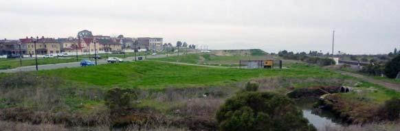
10 Project Overview 40 acre waterfront site Redevelopment of brownfield site Habitat and wetland restoration Transformation into premiere urban waterfront neighborhood Participated in LEED ND Pilot Program Project Location 10


11 Hercules Powder Company, Circa 1900s Present Day 11


12 Hercules Powder Company, Circa 1900s Present Day 12


13 1960: Plant Rebuilt for Fertilizer/Rocket Fuel Present Day 13


14 Project Vision Development Program 1,400 multi family units 115,000 sq. ft. of office 134,000 sq. ft. of flex uses 90,000 sq. ft. neighborhood serving retail 10.9 acre public parks 14

15 Environmental Remediation Manufacturing on site from 1879 to 1979 Site produced explosives, fertilizer and chemicals Placed on CA State Superfund in 1983 Contaminated soils and groundwater From 1989 to present, site remediated d under oversight from DTSC Majority of cleanup completed in 2006 Major Transit Access Routes Transit Center Functional Elements 1. City Access 15


16 Transit Access Creek Restoration 16


17 High Density Housing Mixed Use: Bayfront Boulevard 17


18 Public Spaces Walkability Pedestrian oriented street design Sidewalks on all streets Building entries facing public spaces Transparent building facades Minimal building setbacks On street parking Street trees 18
19 LEED ND GOLD!!! Smart Location and Linkage 18 of 27 Neighborhood Pattern and Design 28 of 44 Green Infra. and Building 14 of 29 Innovation and Design Process 4 of 6 Total 64 of 106 LEED ND Gold For More Information Matt Raimi Raimi + Associates matt@raimiassociates.com Ethan Sischo Anderson Pacific esischo@andersonpacific.com


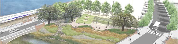
20 Marketplace Redevelopment Denise Pinkston, Partner TMG Partners Marketplace Redevelopment Project 20


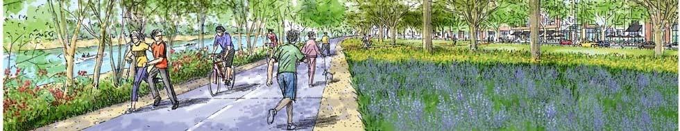
21 Emeryville Marketplace Cars dominate the land: walk through parking to buildings Fully leased buildings: tenant leases pledge free surface parking Most users drive: even with AMTRAK and free BART shuttle Heavy existing traffic: development adds to freeway and surface congestion Brownfield: capped contaminated site with DTSC restrictions Emeryville Marketplace Land Use Transit Oriented High Density mixed use neighborhood TMPOperation over time slowlyrebalances car and transit incentives Parking reduced, structured and paid Transit discounts, multi modal upgrades, new services Designs to encourage walking Active land uses replace cars with people Streets lined with public places in multi storied living and working environment Vibrant neighborhood with varied architecture 21

22 Points In Place Before LEED ND Pilot Created 80 out of 87 points from Site Conditions, Owner s Sustainable Operations, EIR Alternative Project and TMP Site Selection (33 points) Previously developed brownfield, historic structures saved, transit, density, and services. Dense Infill Urban Design (21 points) Dense, mixed use development, walkable streets, and affordable housing Sustainable Property Operation (8 points) Green business certification for food court, grease waste to biofuel re use, LEED AP, recycling and composting program, car share program, accessibility, community outreach, light pollution reduction. Municipal/State Code Requirements (18 points) City required green buildings, energy efficiency, landscape water use reduction, stormwater reduction, transportation management plan. Additional Green Technology Features (7 points) Water reduction, renewable energy (wind/solar/biofuel), infrastructure, energy efficiency and recycled content materials 80 points project is at LEED Platinum! Site Selection (33 points) Previously developed brownfield, historic structures saved, transit available, density nearby and in design, and services available Dense green neighborhood outside central city harder to achieve LEED Rewards Smart Infill in Suburbs with ND Program 22
 Dense, mixed use")


23 Dense Infill Urban Design (21 points) Dense, mixed use development, walkable streets, and affordable housing Pedestrian places dominate land at ground, buildings replace surface parking Density sufficient to support transit and services LEGEND Easily Earned Points Municipal/State Required Points Points with Associated Costs 23


24 Support for Marketplace Redevelopment As a model for Green Infill Projects First Platinum Certified Neighborhood Development in the United States Marketplace Redevelopment The result of 4 years of collaboration with Emeryville: creates people friendly transitoriented neighborhood with shops, services, homes, open space, walkways and gathering places in a sustainable LEED Platinum community 24


25 Township 9 Sacramento CA Laura Bonich, PE, LEED AP Nolte Associates Township 9 LEED for Neighborhood Development American River I-5 Railyards Township 9 65 Acre Mixed use Urban infill Industrial redevelopment Transit oriented Pedestrian friendly Urban parks and open space Downtown Sacramento 25


26 Land Use Plan 13 Parcels 31.7 net acres 27 acres Open space 2359 Residential Units (74 du/ac) 150,000 sf of Retail 840,000 sf of Office About 4 million sf total 5,400 parking spaces Township 9 Land Use Plan Township 9 is being developed by Capital Station 65 LLC (a joint venture between Sacramento based nonprofit Nehemiah Corp. of America and Sacramento developers Ron Mellon and Steve Goodwin) 26


27 Township 9 Existing Cannery and Industrial Site Demolish about 1.4 million sf of existing structures Establish temporary recycling facility LEED for Neighborhood Development GOLD Phase 2 Project SMART LOCATION AND LINKAGE 19 points NEIGHBORHOOD PATTERN AND DESIGN 31 points GREEN CONSTRUCTION AND TECHNOLOGY 8 points INNOVATION IN DEISGN 1 point LEED ACREDITED PROFESSIONAL 1 point TOTAL 60 points 27
28 LEED for Neighborhood Development SMART LOCATION AND LINKAGE POINTS Credit 1 Brownfield Redevelopment Credit 2 High Priority Brownfield Redevelopment 9 Credit 3 Preferred Location 5 Credit 4 Reduced Automobile Dependence Credit 5 Bicycle Network 3 Credit 6 Housing and Jobs Proximity 1 Credit 7 School Proximity 1 Credit dit8 Steep Slope Protection ti Credit 9 Site Design for Habitat or Wetlands Conservation Credit 10 Restoration of Habitat or Wetlands Credit 11 Conservation Management of Habitat or Wetlands 19 TOTAL LEED for Neighborhood Development NEIGHBORHOOD PATTERN AND DESIGN 7 Credit 1 Compact Development 4 Credit 2 Diversity of Uses 3 Credit dit3 Diversity it of Housing Types 1 Credit 4 Affordable Rental Housing Credit 5 Affordable For Sale Housing 2 Credit 6 Reduced Parking Footprint 6 Credit 7 Walkable Streets 2 Credit 8 Street Network 1 Credit 9 Transit Facilities 1 Credit 10 Transportation Demand Management 1 Credit 11 Access to Surrounding Vicinity 1 Credit 12 Access to Public Spaces 1 Credit 13 Access to Active Public Spaces Credit 14 Universal Accessibility 1 Credit 15 Community Outreach and Involvement Credit 16 Local Food Production 31 TOTAL 28

29 LEED for Neighborhood Development GREEN CONSTRUCTION AND TECHNOLOGY Credit 1 LEED Certified Green Buildings Credit 2 Energy Efficiency in Buildings Credit 3 Reduced Water Use 1 Credit 4 Building Reuse and Adaptive Reuse Credit 5 Reuse of Historic Buildings 1 Credit 6 Minimize Site Disturbance through Site Design 1 Credit 7 Minimize Site Disturbance during Construction 1 Credit 8 Contaminant Reduction in Brownfield Remediation Credit 9 Stormwater Management 1 Credit 10 Heat Island Reduction Credit 11 Solar Orientation Credit 12 On Site Energy Generation Credit dit13 On Site Renewable Energy Sources Credit 14 District Heating & Cooling Credit 15 Infrastructure Energy Efficiency Credit 16 Wastewater Management Credit 17 Recycled Content for Infrastructure 1 Credit 18 Construction Waste Management 1 Credit 19 Comprehensive Waste Management 1 Credit 20 Light Pollution Reduction 8 TOTAL Township 9 Design Guidelines 29


30 Township 9 Land Use Transit Area Live work Townhouses Central Mixed Use Riverfront Area Township 9 Transit Area Transit area with light rail and arterial access to I 5 8 to 15 story Mixed offices with possible residential Create densities to support future light rail stop 30


31 Green Line Light Rail to Downtown Township 9 Central Mixed Use R il 3 5 S Retail 3 to 5 Story Live work 2 to 4 story Multi family Residential 31
32 Township 9 Riverfront Area Township 9 Riverfront Area Increase public use and enhance appearance River front area graded to meet levee to eliminate levee as a barrier Visual and Physical connection to American River Buildings along Riverfront Drive limited to 4 stories (residential w/ground floor retail) Two Rivers Trail connects to regional multi use use trail Enhance and complement native vegetation 32


33 Township 9 Riverfront Area Township 9 Riverfront Area 33


34 Township 9 Riverfront Area Oakwood Land with native oak trees and grasses Revegetate Plant non invasive species Control irrigation, fertilizer and surface runoff Township 9 Storm Water Quality STREET SIDE PLANTERS Stormwater Planters PARKING LANES Porous Pavement MEDIANS Vegetated Swales PLAZAS Porous Pavement Other Treatment Control Measures TRANSIT AREA Porous Pavement Stormwater Planter MEASURES ON ALL STREETS Disconnected Sidewalks Interceptor Trees 34
 Stormwater planters Vegetated swales Infiltration trenches Sand filters Vegetated Filter Strips ROOFS Ecoroofs Township 9 Funding California Department of Housing and")

35 Township 9 Storm Water Quality DRIVEWAYS & SURFACE PARKING Porous Pavement BUILDING SETBACKS Stormwater Planters PASEOS Vegetated Swales Stormwater Planters Other Small Treatment Measures PRIVATE OPEN SPACE (BUILDING COURTYARDS) Stormwater planters Vegetated swales Infiltration trenches Sand filters Vegetated Filter Strips ROOFS Ecoroofs Township 9 Funding California Department of Housing and Community Development: Infill Infrastructure Grant Program (IIG) $23 million (Prop 1C) Assist in the new construction and rehabilitation of infrastructure that supports higher density affordable and mixed income housing in locations designated as infill New construction, rehabilitation, and acquisition of infrastructure required as a condition of or approved in connection with approval of Qualifying Infill Projects St Anton building 180 for affordable for rent units 35
36 Township 9 Funding Richards s Boulevard Redevelopment Agency Established in acres $100 million in fees (Federal and Local) Sacramento Regional Transit District Light Rail Green Line Measure A Sales Tax $44 million 2 stations and 1.1 miles of track Moderator: Lillian Henegar, Director of Policy & Outreach -California Redevelopment Association Panelists: Matt Raimi,, AICP Raimi + Associates, Inc. Denise Pinkston, Partner TMG Partners Laura Bonich,, PE, LEED AP Nolte Associates QUESTIONS? 36
LEED-ND 101: Practical Strategies for Achieving Sustainability Goals. Travis Parker Lakewood Planning Director
 LEED-ND 101: Practical Strategies for Achieving Sustainability Goals Travis Parker Lakewood Planning Director Metro Vision Idea Exchange Oct 11, 2012 West Corridor Stations West Corridor Overview West
Using AutoCAD Civil 3D and ESRI ArcGIS to meet LEED-ND (Neighborhood Development) Requirements NDIA O Brien & Gere. All Rights Reserved.
 Requirements NDIA O Brien & Gere. All Rights Reserved.") Using AutoCAD Civil 3D and ESRI ArcGIS to meet LEED-ND (Neighborhood Development) Requirements NDIA 12457 1 Using AutoCAD Civil 3D and ESRI ArcGIS to meet LEED-ND (Neighborhood Development) Requirements
Using AutoCAD Civil 3D and ESRI ArcGIS to meet LEED-ND (Neighborhood Development) Requirements NDIA 12457 1 Using AutoCAD Civil 3D and ESRI ArcGIS to meet LEED-ND (Neighborhood Development) Requirements
New Partners for Smart Growth Conference February 5, 2010
 Dan Stroh, Planning Director City of Bellevue Planning and Community Development Bellevue, WA New Partners for Smart Growth Conference February 5, 2010 Summary of Project Long-range plan update for Bel-Red
BRISTOL PLACE MASTER PLAN. Prepared for the City of Champaign
 BRISTOL PLACE MASTER PLAN Prepared for the City of Champaign TABLE of CONTENTS 4 Bristol Place Master Plan Introduction 5 Current Aerial 6 Master Plan 9 Building Types 10 Dimensional Plan 11 LEED-ND Scorecard
City of Langford Green Development Checklist
 City of Langford Green Development Checklist The following Green Development Checklist creates a sustainability standard for all comprehensive development within the City of Langford. The commitments made
CHAPTER 7: Transportation, Mobility and Circulation
 AGLE AREA COMMUNITY Plan CHAPTER 7 CHAPTER 7: Transportation, Mobility and Circulation Transportation, Mobility and Circulation The purpose of the Transportation, Mobility and Circulation Chapter is to
LEED for Neighborhood Development. A Brief Overview
 LEED for Neighborhood Development A Brief Overview What is LEED ND? LEED for Neighborhood Development First national standard for neighborhood design Developed as a partnership U.S. Green Building Council
Transportation. Strategies for Action
 Transportation A major priority for the Overlake Neighborhood is to develop a multimodal transportation system. To achieve this system, a balance has to be found among travel, circulation and access needs;
What does LEED characterize?
 LEED Certification What does LEED characterize? Leadership in Energy and Environmental Development How was it created? Created by United States Green Building Council (USGBC) in 1998 Developed by architects
A larger version of this map is located on the last page of this PDF.
 MAP Committee Input McLoughlin Area Draft Vision Map A larger version of this map is located on the last page of this PDF. 1. The map above is intended to portray a vision for the McLoughlin area. It highlights
greenprint midtown SUSTAINABILITY ACTION PLAN 2012
 greenprint midtown SUSTAINABILITY ACTION PLAN 2012 MIDTOWN ALLIANCE SOUTHFACE ENERGY INSTITUTE RENAISSANCE PLANNING GROUP SUSTAINABLE ATLANTA PERKINS+WILL 2 GREENPRINT MIDTOWN 1. Introduction Sustainability
EXISTING COMPREHENSIVE PLAN
 EXISTING COMPREHENSIVE PLAN Town Center Land Use Element: V. LAND USE POLICIES Town Center Mercer Island's business district vision as described in "Your Mercer Island Citizen-Designed Downtown" was an
Developer s Program. The Station at East 54
 Developer s Program The Station at East 54 Existing Conditions The Station at East 54 is proposed for a 1.12 acre site at the northeast corner of Hamilton Road and Prestwick Road, tucked between the East
Silverdale Regional Center
 Silverdale Regional Center Vision for Silverdale Regional Center The Silverdale Regional Center Plan (Plan) will guide the evolution of the Silverdale Regional Center from a collection of strip malls and
Gold Line Bus Rapid Transit Transit Oriented Development (BRTOD) Helmo Station Area Plan
 Helmo Station Area Plan") Appendix F Gold Line Bus Rapid Transit Transit Oriented Development (BRTOD) Helmo Station Area Plan Introduction and Purpose of the Plan The Gold Line Bus Rapid Transit facility is an eleven-mile dedicated
Appendix F Gold Line Bus Rapid Transit Transit Oriented Development (BRTOD) Helmo Station Area Plan Introduction and Purpose of the Plan The Gold Line Bus Rapid Transit facility is an eleven-mile dedicated
Cumberland Region Tomorrow is a private, non-profit, citizen based regional organization working with Greater Nashville Regional Council
 Cumberland Region Tomorrow is a private, non-profit, citizen based regional organization working with Greater Nashville Regional Council and others in the public and private sectors, dedicated to planning
Secrest Short Cut and Monroe Expressway Small Area Plan AUGUST 29, 2018
 Secrest Short Cut and Monroe Expressway Small Area Plan AUGUST 29, 2018 Background and Process Monroe Expressway will be open by the end of 2018 Union County and Indian Trail identified a need to revisit
Route 347. New York State Department of Transportation Region 10, Long Island. THE GREENING of ROUTE 347
 The GREENING of Route 347 The Greening of Route 347 The Greening of Route 347: History 3 The Greening of Route 347 4 The Greening of Route 347 5 The Greening of Route 347 Smith Haven Mall 6 The Greening
Ten Mile Creek Planning Area
 PLANNING AREA POLICIES TEN MILE CREEK Ten Mile Creek Planning Area Location and Context The Ten Mile Creek Planning Area ( Ten Mile Creek area ) is located south of the current Boise AOCI, generally south
A BLUEPRINT FOR BROCKTON A CITY-WIDE COMPREHENSIVE PLAN
 A BLUEPRINT FOR BROCKTON A CITY-WIDE COMPREHENSIVE PLAN Public Meeting October 2016 1 Plan Summary and Discussion Public Meeting May 4 2017 City of Brockton Bill Carpenter, Mayor Department of Planning
Sacramento Area Council of Governments (SACOG)
") Sacramento Area Council of Governments (SACOG) The Blueprint Vision The SACOG Board of Directors adopted the Preferred Blueprint Scenario in December 2004, a bold vision for growth that promotes compact,
Sacramento Area Council of Governments (SACOG) The Blueprint Vision The SACOG Board of Directors adopted the Preferred Blueprint Scenario in December 2004, a bold vision for growth that promotes compact,
Municipal Plan*Assessment
 Municipal Plan*Assessment This tool was developed to assist in reviewing municipal master plans and in determining if these plans are consistent with smart growth principles, neighboring municipal plans,
Concord Community Reuse Project Goals and Guiding Principles. Overarching Goals (OG)
") Concord Community Reuse Project Goals and Guiding Principles Overarching Goals (OG) No priority is implied by the order of presentation of the goals and guiding principles. Overarching goals for the Concord
Concord Community Reuse Project Goals and Guiding Principles Overarching Goals (OG) No priority is implied by the order of presentation of the goals and guiding principles. Overarching goals for the Concord
ICLEI Webinar Sustainability in the Master Plan and Zoning Code
 ICLEI Webinar Sustainability in the Master Plan and Zoning Code Sustainability in Grand Rapids 2000 2002 New Master Plan 2004 2005 Neighborhood Pattern Workbook 2006 2007 Form-Based Zoning Ordinance 2007
C. Westerly Creek Village & The Montview Corridor
 C. Westerly Creek Village & The VISION Community Vision When the goals of the city are achieved Westerly Creek Village, a distinctive community defined by Montview Boulevard and Westerly Creek, is a strong
UBC URBAN STUDIO, FALL 2002 PEDESTRIAN ORIENTED
 SECTION B PEDESTRIAN ORIENTED PATTERN: CITY OF VANCOUVER B.1 Vision Overview Regional Framework Energy 50% of all energy used within the Region to be produced by the Region. Energy production methods to
José Campos Manager of Planning and Design Review SPUR San José Symposium October 12, 2018
 1 Transbay: Freeways to New Ways José Campos Manager of Planning and Design Review SPUR San José Symposium October 12, 2018 2 Transbay freeway land pre-1989 3 1989 Loma Prieta Earthquake 4 TRANSBAY c.
1.0 VISION STATEMENT. December 6, PRINCIPLES
 Vision Statement Lincoln Regional Airport 1.0 VISION STATEMENT 1.1 City LOCATION of AND OVERVIEW The Easton Lincoln Place Land Use Master Plan identifies the principles, goals, policies, and standards
SPRINGHILL LAKE TRANSIT VILLAGE
 Greenbelt Metro Area Sector Plan - Subarea Design Policies and Guidelines - Springhill Lake Transit Village 113 SPRINGHILL LAKE TRANSIT VILLAGE Residential Neighborhood and Village Center CONCEPT Springhill
FUNDING CORRIDOR REVITALIZATION
 FUNDING CORRIDOR REVITALIZATION Integrated corridor planning for the 21 st Century America Planning Association Annual Conference Atlanta, GA April 27, 2014 Mariia Zimmerman, MZ Strategies, LLC mariia@mzstrategies.com
Elizabeth Ackerman Architect LLC/LEED AP PO Box 382 Lambertville, NJ
 Elizabeth Ackerman Architect LLC/LEED AP PO Box 382 Lambertville, NJ 08530 609.397.0979 www.eaarchitect.com com 1 SUSTAINABLE Development Meets Present Needs Future Generations to meet their needs in a
Planning Commission March 14, Presented by: City of Bellingham Port of Bellingham
 Planning Commission March 14, 2013 Presented by: City of Bellingham Port of Bellingham 1 Agenda Waterfront District Background Waterfront District Proposal Overview Sub-area Plan Development Regulations
Urban Sustainability Strategies in the US: An Examination into the LEED - Neighborhood Development Program
 Urban Sustainability Strategies in the US: An Examination into the LEED - Neighborhood Development Program Russell M. Smith, Ph.D. Associate Professor of Geography Winston-Salem State University August
Easton. Smart Growth Through Innovation. Easton
 Hazel Ave. Sunrise Blvd. Prairie City Rd. Smart Growth Through Innovation offers a unique opportunity to meet the region s future need for jobs and housing. It embodies smart growth principles advocated
Planning and Design: Applied LID Techniques Redevelopments, Housing, Mixed Use, Infrastructure
 Civil Engineering Landscape Architecture Environmental Restoration Planning Planning and Design: Applied LID Techniques Redevelopments, Housing, Mixed Use, Infrastructure Peg Staeheli, ASLA, LEED AP March
CHAPTER 3 VISION, GOALS, & PLANNING PRINCIPLES. City of Greensburg Comprehensive Plan. Introduction. Vision Statement. Growth Management Goals.
 CHAPTER 3 VISION, GOALS, & PLANNING PRINCIPLES Introduction The Greensburg Comprehensive Plan is intended as a working community document. A combination of long and short-term goals, this document is intended
Somers Point Master Plan
 Somers Point Master Plan Progress Report and Public Meeting August 20, 2014 Master Plan Reexamination Municipal Land Use Law require that all municipalities reexamine their master plan every ten years.
THE POLICY FRAMEWORK FOR WALKABLE COMMUNITIES. Community Technical Assistance Program Building Active Communities Institute March 2016
 THE POLICY FRAMEWORK FOR WALKABLE COMMUNITIES Community Technical Assistance Program Building Active Communities Institute March 2016 ACTIVE COMMUNITIES BACK THEN ACTIVE COMMUNITIES BACK THEN Lifestyle
Preliminary Recommendations Tk Takoma/Langley Crossroads Sector Plan
 Preliminary Recommendations Tk Takoma/Langley Crossroads Sector Plan Vision is to achieve a Transit Oriented, pedestrian friendly Community that Celebrates and builds upon the cultural Diversity of the
Dwelling Units Max 12 dwelling units per acre/min 8 dwelling units per acre. Development Mix 80% non residential/20% residential
 13. OSTEEN LOCAL PLAN Background: The Osteen Local Plan area is located in southwest Volusia County along the SR 415 corridor between Lemon Bluff Road and Acorn Lake Road and includes 3,990 acres. The
Plano Tomorrow Vision and Policies
 Plano Tomorrow Vision and Policies PLANO TOMORROW PILLARS The Built Environment The Social Environment The Natural Environment The Economic Environment Land Use and Urban Design Transportation Housing
FRUITVALE TRANSIT VILLAGE (Phase 2) Residential Project
 Residential Project") FRUITVALE TRANSIT VILLAGE (Phase 2) Residential Project DEVELOPER: SIGNATURE PROPERTIES ARCHITECT: HKIT ARCHITECTS April 23, 2010 TABLE OF CONTENTS 3 Vision 4 Description of Site 5 Guiding Concepts 6
FRUITVALE TRANSIT VILLAGE (Phase 2) Residential Project DEVELOPER: SIGNATURE PROPERTIES ARCHITECT: HKIT ARCHITECTS April 23, 2010 TABLE OF CONTENTS 3 Vision 4 Description of Site 5 Guiding Concepts 6
Economy Vision Statements: Social Wellbeing Vision Statements: Natural Environment Vision Statements:
 Economy Vision Statements: 1. Our business environment makes us a region of choice for new employers as we encourage entrepreneurship and have a vibrant, diversified and resilient regional economy. 2.
Integrated Urban Development. April Reflections from the NZPI Study Tour of Portland, Seattle and Vancouver
 Integrated Urban Development April 2009 Reflections from the NZPI Study Tour of Portland, Seattle and Vancouver Integrated Urban Development Urban Growth Management Transportation Transit Orientated Mixed
WEST OAKLAND SPECIFIC PLAN Final Plan. 2. Vision & Goals. 2.1 Community-Based Goals and Objectives
 WEST OAKLAND SPECIFIC PLAN Final Plan 2. Vision & Goals 2.1 Community-Based Goals and Objectives June 2014 2: Vision & Goals The vision of the West Oakland Specific Plan is to see this remarkable community
DOWNTOWN AREA PLAN. June 9, 2009
 DOWNTOWN AREA PLAN June 9, 2009 Issues Identified by Councilmembers Overlap with Southside Plan Southwest Residential Area & Herrick Shadows & Residential Areas Shadows on Streets & Canyon Effect Transit
Draft Bergamot Area Plan
 ATTACHMENT 1 Draft Bergamot Area Plan Taskforce on the Environment April 15, 2013 www.bergamotplan.net 1 Overview WHAT IS THE BERGAMOT AREA PLAN? A Community-Based Planning Document Guiding the Future
Danvers High Street I-1 District Study
 Danvers High Street I-1 District Study Presentation of Final Recommendations Planning Board Presentation June 26 th, 2018 1 Introductions Metropolitan Area Planning Council Sam Cleaves AICP, Principal
City of Long Beach. creating vibrant and exciting places
 City of Long Beach creating vibrant and exciting places Land Use Element Urban Design Element Overview of the two draft General Plan elements Discuss areas of change Economic goals of the plans Case study
Coastal Smart Growth Approaches for Working Waterfront Preservation, Implementing Locally-Based Strategies and Solutions
 Coastal Smart Growth Approaches for Working Waterfront Preservation, Implementing Locally-Based Strategies and Solutions National Working Waterfronts Symposium March 26, 2013 Presented by: Lydia Bennett
Wasatch CHOICE for 2040
 Wasatch CHOICE for 2040 Economic Opportunities We Can Choose a Better Future We enjoy an unparalleled quality of life along the Wasatch Front. People from all over the world are drawn to our stunning scenery,
Kelowna Sustainability Checklist
 Kelowna Sustainability Checklist The City of Kelowna endeavours to Sustain the Environment. Encourage development and land use changes that will not compromise the ability of future generations to meet
Tennessee Stormwater Management Program. Stormwater Management Site Assessment and Inventory Checklist. Quick Check o Vicinity Map within Watershed
 Tennessee Stormwater Management Program Project Name: Location: File Number: Reviewer: Date of Submittal: Review Date: Project Meeting Chronology: Type of Meeting: Date: Stormwater Management Site Assessment
Windsor Locks Transit-Oriented Development Planning Grant Request. Project Background
 Windsor Locks Transit-Oriented Development Planning Grant Request Project Background Downtown Windsor Locks runs along Main Street in the vicinity of the intersection of Routes 159 and 140. The current
S A C R A M E N T O C O U N T Y JACKSON HIGHWAY & GRANT LINE EAST VISIONING STUDY
 JACKSON HIGHWAY & GRANT LINE EAST S A C R A M E N T O C O U N T Y P L A N N I N G D E P A R T M E N T SUMMARY AND WORKBOOK November 19, 2008 History of the Visioning Study Sacramento County has two growth
The Vision. Photo provided by The Minervini Group. 46 Vision, Objectives & Strategies
 Vision, Objectives & Strategies The is the public framework and guide for future development of the Grand Traverse Commons. The establishes public polices for infrastructure, the preservation of natural
Appendix E: Illustrative Green Infrastructure Examples
 Appendix E: Illustrative Green Infrastructure Examples Integrating LID into San Francisco s Urban Landscape Figure E. High-density Residential Figure E. Low-density Residential Figure E. Mixed Use 7 Figure
Taming Tysons Corner Transforming the Quintessential Edge City
 Taming Tysons Corner Transforming the Quintessential Edge City Transit is the greatest catalyst for change at Tysons, but how do we take advantage of this billion-dollar investment? If transit is built
Sustainable Community Index Defining smart growth in our communities RMLUI
 Sustainable Community Index Defining smart growth in our communities RMLUI SCI not CSI 25-75 mph 300 mile range 12 x 7 5 mph Around 6 ft. in height ¼ mile walking distance standard 10-15 mph 7-mile
Meeting Agenda. 1. Introductions (5 min)
") Meeting Agenda Monaca, PA Ohio River Brownfields Redevelopment Planning Federal/State/Regional Partners Meeting June 5, 2012; 3-4pm EDT Conference call-in #: 1-866-299-3188 Conference code: 202 566 0633#
Meeting Agenda Monaca, PA Ohio River Brownfields Redevelopment Planning Federal/State/Regional Partners Meeting June 5, 2012; 3-4pm EDT Conference call-in #: 1-866-299-3188 Conference code: 202 566 0633#
Gas Stations ottawa.ca
 Urban Design Guidelines for Gas Stations ottawa.ca Ce document est disponible en français sur ottawa.ca. This document is available in French on ottawa.ca. Approved by City Council May 24, 2006 City of
Mariposa Lakes. Planned Community. Project Overview. Stockton, CA
 Planned Community Stockton, CA Project Overview March 2007 Summary of Proposed Community is a master-planned community proposed for development on approximately 3,810 acres in southeast Stockton. In 2004,
Information Session July 25, 2018
 Concord Pike (US 202) Master Plan Information Session July 25, 2018 1 Concord Pike (US 202) Master Plan 2018 Project Partners Wilmington Area Planning Council Delaware Department of Transportation New
Description of Preferred Alternative
 Chapter 2 Description of Preferred Alternative 2.1 Introduction This chapter of the programmatic Sammamish Town Center Sub-area Plan Final EIS provides a more detailed description of the Preferred Alternative
PORT OF VANCOUVER WATERFRONT DEVELOPMENT. Concept Development Plan City Center Redevelopment Authority April 20, 2017
 PORT OF VANCOUVER WATERFRONT DEVELOPMENT Concept Development Plan City Center Redevelopment Authority April 20, 2017 Port History PORT ESTABLISHED 1912 TERMINAL 1 ACQUIRED 1925 GWM SIGNS LEASE 1935 HARBOR
Northwest commuter rail station US 36 BRT. Westminster Station
 Northwest commuter rail station Westminster Station US 36 BRT Westminster Center US 36 & Church Ranch Broomfield Flatiron/96 th St. US 36 & McCaslin Table Mesa Boulder Junction 13-month effort that will
Hopkins. Development Guidelines May Overview. Sponsored by: Blake Road Corridor Collaborative City of Hopkins
 Hopkins Blake Road LRT Station Area Development Guidelines May 2015 Sponsored by: Blake Road Corridor Collaborative City of Hopkins Overview Hopkins is a dynamic community of over 17,000 residents located
TOWN COUNCIL / PLANNING COMMISSION
 Workshop #3 TOWN COUNCIL / PLANNING COMMISSION January 20, 2011 Consultant Team In Attendance Tonight BMS Design Group Nevada City and San Francisco Michael Smiley, AICP, ASLA Partner-in-Charge Nancy L.
PLAN ELEMENTS WORKSHOP. April 5, 2016
 PLAN ELEMENTS WORKSHOP April 5, 2016 needs more housing. But there is no one-size fits-all solution. Every neighborhood has its own character. In some places, density is not only appropriate it is badly
TREASURE COAST REGIONAL PLANNING COUNCIL M E M O R A N D U M. To: Council Members AGENDA ITEM 5H
 TREASURE COAST REGIONAL PLANNING COUNCIL M E M O R A N D U M To: Council Members AGENDA ITEM 5H From: Date: Subject: Staff October 17, 2008 Council Meeting Local Government Comprehensive Plan Review Draft
Status Report: MD 355 Project
 Status Report: MD 355 Project OCTOBER 2006 M-NCPPC MONTGOMERY COUNTY PLANNING DEPARTMENT Summary of Community Comments, and break to the Results of the MD 355 Participation Session Brookside Gardens -
The Benefits and Challenges Associated with Green Infrastructure Practices
 The Benefits and Challenges Associated with Green Infrastructure Practices Thomas M. Evans ASLA, LEED AP Regional Green Infrastructure Design Services Director OWEA Technical Conference, June 20, 2013
EXISTING PLANS Harriet Festing Center for Neighborhood Technology Midlothian Community Meeting March 12, 2015
 EXISTING PLANS Harriet Festing Center for Neighborhood Technology Midlothian Community Meeting March 12, 2015 BENEFITS Bring economic, community + environmental benefits Enhance property values Use
APPENDIX D: BACKGROUND AND VISION
 APPENDIX D: BACKGROUND AND VISION BACKGROUND A. Specific Plan Location Jordan Downs is located at 9800 Grape Street in Los Angeles, California, 90002. The Jordan Downs Urban Village Specific Plan area
Vancouver. Title of the Initiative. Initiative Duration. Submitted by. Comments by the Jury
 134 Vancouver Title of the Initiative Initiative Duration Submitted by Comments by the Jury Visionary Vancouver: Creating a Welcoming and Sustainable Place for All 2009-2020 Wendy Au, Deputy City Manager,
ROBBINSDALE LRT STATION CDI DEVELOPMENT GUIDELINES
 August 2018 OVERVIEW The City of Robbinsdale has a prime-opportunity site in the middle of the 13 mile stretch of the Bottineau LRT corridor / Blue Line extension. Robbinsdale offers a prominent, vital,
Integrating LEED ND & SITES Into Your Design Approach
 Integrating LEED ND & SITES Into Your Design Approach Joshua C. Sloan, RLA, ASLA, AICP, LEED AP ND, SITES AP Stephen K. Cook, RLA, ASLA, LEED AP O+M VIKA MD, LLC Planning Landscape Architecture Engineering
The University District envisions, in its neighborhood
 Envisioning the University District Link Light Rail in Seattle s neighborhoods CIY OF SEALE CONCEP-LEVEL SAION AREA PLANNING RECOMMENDAION RESOLUION # 30165 EXHIBI L Vision 08.2000 he University District
A. WHAT IS A GENERAL PLAN?
 I. Introduction A. WHAT IS A GENERAL PLAN? A general plan is the planning guideline for the future of a city. It contains goals and policies which regulate urban development, the protection of the natural
understanding Green Infrastructure In Zoning
 understanding Green Infrastructure In Zoning Purpose Measurable standards can be adopted within municipal zoning codes, and subdivision and stormwater regulations, to promote a comprehensive approach to
Cherokee. Corporate Headquarters 111 East Hargett Street Suite 300 Raleigh, NC
 Cherokee Corporate Headquarters 111 East Hargett Street Suite 300 Raleigh, NC 27601 919-743-2500 Denver 4600 S. Ulster Street Suite 500 Denver, CO 80237 303-689-1460 London 41-43 Maddox Street London W1S
Sprawling urban development and auto-dominated streets
 Neighborhood-Scale Planning Tools to Create Active, Livable Communities Sprawling urban development and auto-dominated streets make it nearly impossible for people to integrate walking or bicycling into
UNIVERSITY OF ARKANSAS FOR MEDICAL SCIENCES
 HEALTHY INNOVATIONS A Sustainable Business Village Master Plan Concept SUSTAINABILITY - the linking of economic vitality; ecological integrity, and social well-being within a unified conceptual framework
Northwest Rail Corridor and US 36 BRT Development Oriented Transit Analysis 4.4 STATION AREA FINDINGS
 4.4 STATION AREA FINDINGS Each station is different, and each one requires a separate set of recommendations based on the vision for the site. This section outlines an initial TOD strategy and recommendations
Horizon 2035 Land Use and Transportation Element
 CITY OF SUNNYVALE Horizon 2035 Land Use and Transportation Element City Council Study Session March 7, 2017 Overview General Plan Context Mixed Use Villages Transportation Mode & Parking General Plan Policy
Silver Line CPAM UPDATE. Transportation and Land Use Committee October 14, 2016
 Silver Line CPAM UPDATE Transportation and Land Use Committee October 14, 2016 Purpose Recap Project History and Map Changes Provide Overview of CPAM Components Discuss Transportation Impacts Discuss Fiscal
Coast Highway Oceanside, California
 Coast Highway Oceanside, California Coast Highway Plan Zones What We ve Heard - Walkable/Bikeable Community (Senior and Child Friendly) -Wider Sidewalks -Street Trees -Traffic Calming -Bike Lanes -Paseos
GOING GREEN! NEWBURYPORT S PLAN FOR THE FUTURE
 GOING GREEN! NEWBURYPORT S PLAN FOR THE FUTURE Jennifer K. Lachmayr, PE, BCEE Kathryn B. Edwards, PE November 2015 Agenda Background Little River Flood Study Little River Pilot Program Vision for Implementation
Future Land Use SAMPLE RECOMMENDATIONS
 SAMPLE RECOMMENDATIONS Future Land Use The Future Land Use Chapter of the Master Plan builds upon prior chapters examining the existing conditions in their respective topic areas to present a comprehensive
Subregion 4 Central Avenue-Metro Blue Line Corridor Transit-Oriented Development (TOD) Implementation Project. Community Meeting April 27, 2011
 Implementation Project. Community Meeting April 27, 2011") Subregion 4 Central Avenue-Metro Blue Line Corridor Transit-Oriented Development (TOD) Implementation Project Community Meeting April 27, 2011 Overview Introduction to Subregion 4 TOD Implementation Program
Subregion 4 Central Avenue-Metro Blue Line Corridor Transit-Oriented Development (TOD) Implementation Project Community Meeting April 27, 2011 Overview Introduction to Subregion 4 TOD Implementation Program
SEVEN PRINCIPLES OF FRIENDLY LANDSCAPING
 SEVEN PRINCIPLES OF FRIENDLY LANDSCAPING Gretchen Schubeck Executive Director, Bay-Friendly Coalition PRESENTATION OVERVIEW What is Friendly? Overview of 7 Principles Benefits Bay-Friendly Tools, Training
LEED FOR PLANNERS OCT 2009
 OCT 2009 What is LEED ND Overview History LEED ND Rating System Smart location and linkage Neighborhood Pattern and Design Green Infrastructure and Buildings Innovation and Design Process Project Example
Introduction. Community Outreach Approach. Sacramento Valley Station Master Plan. Online Questionnaire Summary of Feedback.
 Introduction Located in the northwest sector of downtown Sacramento, the Sacramento Valley Station (SVS) is the primary rail station in northern California and the seventh busiest station in the country.
New Town Mixed Use District
 New Town Mixed Use District Montgomery County Planning Commission 2009 Annual Conference PA Chapter of the American Planning Association October 6, 2009 What is NTMU? More urban style of development Complementary
CHAPTER 8 ISSUES, CONCERNS, CONSTRAINTS AND OPPORTUNITIES
 CHAPTER 8 ISSUES, CONCERNS, CONSTRAINTS AND OPPORTUNITIES Introduction This River Conservation Plan was developed during a time of tremendous activity and effort in planning the transformation of the Delaware
Green Affordable Housing
 Green Affordable Housing www.lihi.org Presented by Sharon Lee Executive Director, Low Income Housing Institute LIHI has been providing homes and services for Puget Sound s neediest citizens since 1991.
MONTGOMERY COUNTY METRO STATION AREA DESIGN CHARRETTE
 MONTGOMERY COUNTY METRO STATION AREA DESIGN CHARRETTE Shady Grove Metro Station Area Charrette Closing Presentation October 25-28, 2000 MONTGOMERY COUNTY, MD M-NCPPC Design Collective, Inc. Architects
40 Years of Smart Growth Arlington County s Experience with Transit Oriented Development in the Rosslyn-Ballston Metro Corridor
 40 Years of Smart Growth Arlington County s Experience with Transit Oriented Development in the Rosslyn-Ballston Metro Corridor A presentation by the Arlington County Department of Community Planning,
4.1.3 LAND USE CATEGORIES
 4.1.3 LAND USE CATEGORIES a. City Center District The City Center District incorporates the existing character and mix of uses in downtown Belmont to encourage redevelopment and new development in keeping
Transit-Oriented Development
 Transit-Oriented Development Path to Sustainability West Windsor February 22, 2007 George S. Hawkins Context for Presentation NJ Future is a non-partisan, 501(c)3 non-profit organization. Offer perspective,