Student Exploration of CE Visualization, CGA Code and Performance Reporting Tools
|
|
|
- Jeffery Norman
- 6 years ago
- Views:
Transcription
1 Student Exploration of CE Visualization, CGA Code and Performance Reporting Tools
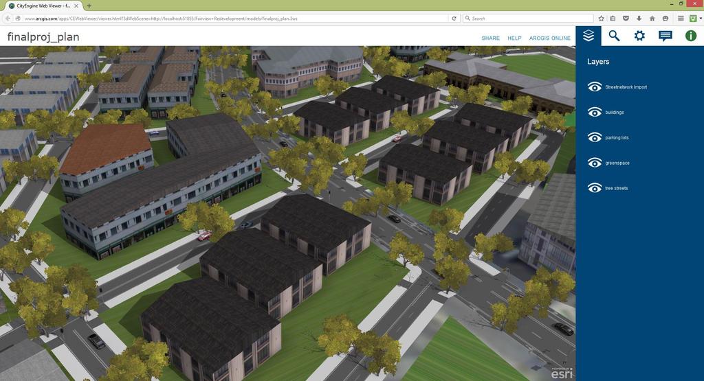
2 Project background and context Urban design performance: challenges in scale and level of detail for reporting Design requirements for sustainability and livability Student designs and models Performance reporting Behind the models: a brief look at CGA coding for performance calculations
3 After Turner and Dailey, 2008
4 Challenges in scale and level of detail District scale falls between areas of current focus; potential to provide link across scales Planning scales: Resilient sustainable communities: mapping, analysis of wide variety of variables (eg, Cutter et al 2014) Site and building scale Ecosystem services assessment frameworks not well agreed upon (eg, Haines-Young and Potschin, 2008)

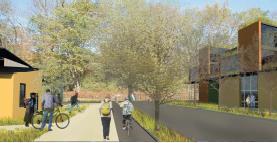
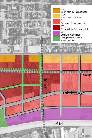
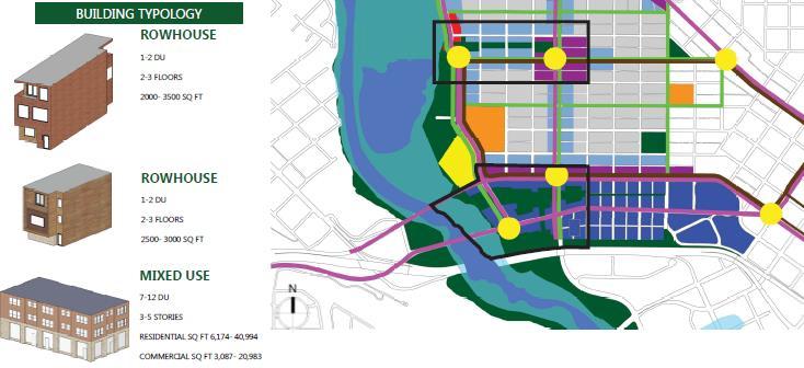
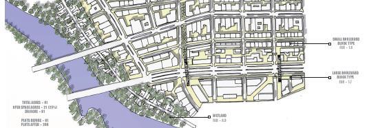
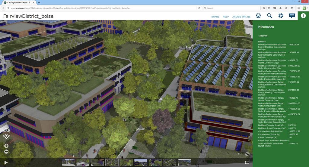
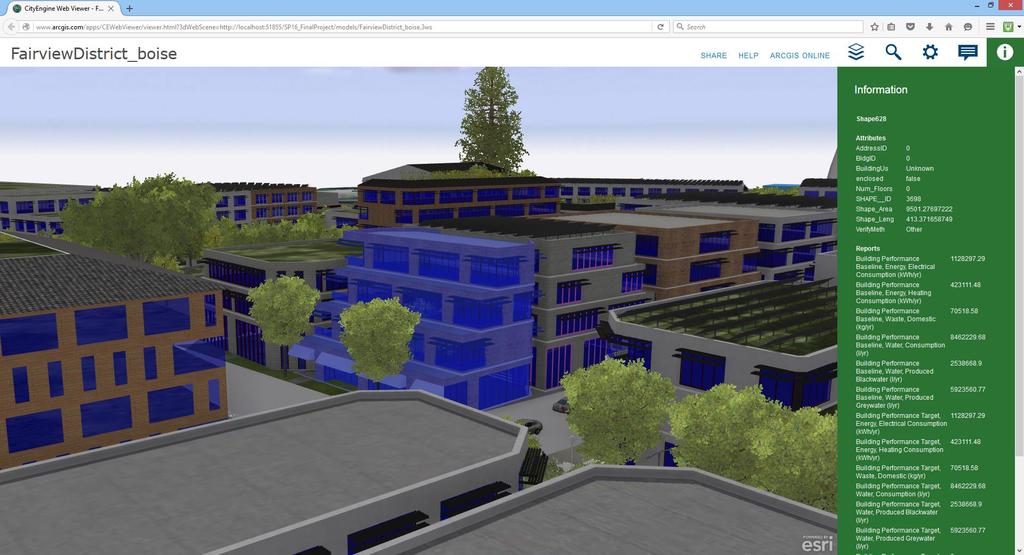
5 Fairview subdistrict, Boise s West End City Center 2000 ~ 95 ac Vacant / underutilized parcels Central location High redevelopment priority Geothermal line Main subwatershed
6 Required: City Code and Downtown Design Guidelines Other guidance: LEED ND NPDES permit, Green Stormwater Infrastructure Guidelines Livable Streets design guidelines LIV District goals Recent built projects (typologies, costs, etc)
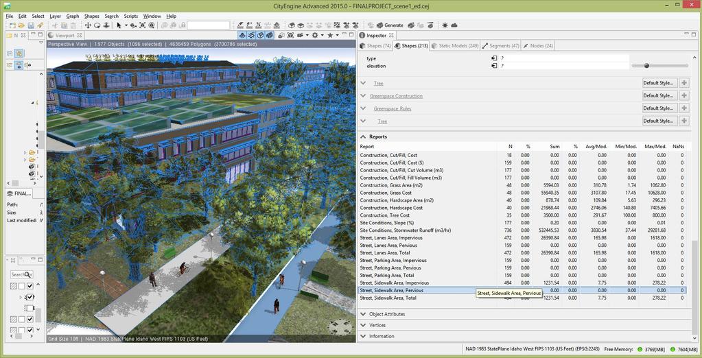
7 3 Stage Process: 1. Create conceptual development plan, summarize sustainability/livability goals and requirements Review existing CGA code for attribution, reporting capabilities 2. Develop massing model with major urban form, structure Modify CGA code as needed 3. Refinement and reporting
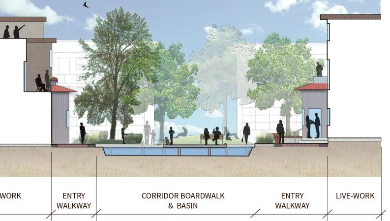
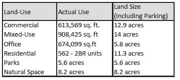
8 Parking & Transit: integrate; 30% parking reduction, keep surface parking close to storefronts, interior of block or structured Bike & Pedestrian: Ped-oriented, good regional connectivity; 5 protected bike lanes both sides on all major roads; sidewalks 5-10 Setbacks: ; Storefront commercial building minimum 40 depth; Façade breaks at minimum 122 ; vertical modulation required minimum inset; +3 rd story 10 Stormwater: 90% on-site management Building energy consumption reduction 20% Street trees 40 o.c.; preferred native veg mix with clear zones Street lights o.c.
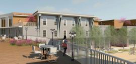
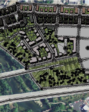
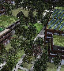
9 Traditional design models

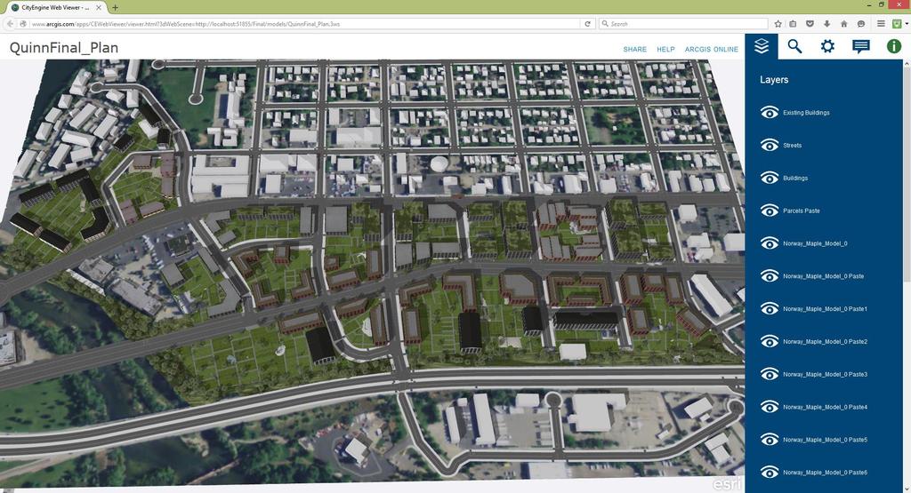
10 Summaries & Plans:
11
12
13
14
15
16
17

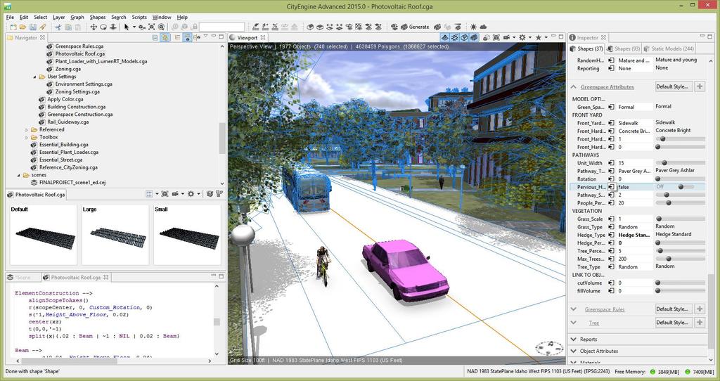
18 Reporting (sample CGA)
19 Reporting Current Limitations (sample CGA for Stormwater) Fine tuning for local conditions, similar to other assessment tools Limitations of CGA code - coarse models, or challenges in accounting for detail in models developed in other programs (e.g. Revit, Vue) Accounting for changes in infrastructure performance, e.g., traffic patterns and volumes Exporting for feedback looping Reporting needs refining for each set of local conditions How do we incorporate standard measures, especially for qualitative attributes?
20 Students demonstrate better understanding of site context and scale, don t overbuild Developing standard CGA code modules tied to common assessment tools is challenging: Economic models / pro forma District level energy analysis Traffic / transportation models Other demographic and socioeconomic models Design may be handled better in other environments, imported to CE for reporting capabilities. Good visual communication regarding general aspects of redevelopment
21 Selected References Cutter, S L, K D Ash, C T Emrich The geography of community disaster resilience. Global Environmental Change 29:65 77 Ervin, S M Digital landscape modeling and visualization: a research agenda. Landscape and Urban Planning 54.1: Jessop, M Digital visualization as a scholarly activity. Literary and Linguistic Computing 23.3: Haines-Young, R. and M. Potschin Methodologies for Defining and Assessing Ecosystem Services. Final Report, JNCC, Project Code C , 69 pp. Ross, H and F Berkes Research Approaches for Understanding, Enhancing, and Monitoring Community Resilience, Society & Natural Resources, 27:8, Schmitt, G A Planning Environment for the Design of Future Cities in Arisona, S M, et al, eds., Digital Urban Modeling and Simulation. Berlin: Springer Turner, R. K. and Daily, G. C : The ecosystem services framework and natural capital conservation. Environmental & Resource Economics 39(1): Wergles, N. and A. Muhar The role of computer visualization in the communication of urban design A comparison of viewer responses to visualizations versus on-site visits." Landscape and urban planning 91.4: Supported in part by NSF EPSCoR Research Infrastructure Improvement award: Managing Idaho s Landscapes for Ecosystem Services (MILES) Award #IIA , 6/15/13-5/31/18
Atlanta BeltLine Subarea 3 Master Plan Update
 Atlanta BeltLine Subarea 3 Master Plan Update April 14, 2018 Workshop Meeting 1 22 miles, connecting 45 neighborhoods 22 MILES of transit 46 MILES of streetscapes and complete streets 33 MILES of urban
Citizen Advisory Group Meeting 5: Land Use April 14, 2011
 Citizen Advisory Group Meeting 5: Land Use April 14, 2011 Meeting Agenda 1. Background Review 2. Transportation Follow-up 3. PED Overlay Approach 4. Land Use Mapping 5. Group Exercise 6. Wrap-up and Next
 Community Workshop #2 December 4, 2014 Team Tonight s Agenda 6:00 pm Welcome! 6:05 pm The Future of Downtown Tustin Ideas, Strategies and Recommendations 6:35 pm Questions and Comments 6:50 pm Open
Scope of Services. River Oaks Boulevard (SH 183) Corridor Master Plan
 Corridor Master Plan") Scope of Services River Oaks Boulevard (SH 183) Corridor Master Plan PROJECT AREA The project area consists of the River Oaks Boulevard (SH 183) corridor bounded by SH 199 at the northern end and the Trinity
Scope of Services River Oaks Boulevard (SH 183) Corridor Master Plan PROJECT AREA The project area consists of the River Oaks Boulevard (SH 183) corridor bounded by SH 199 at the northern end and the Trinity
North Downtown Specific Plan MEMORANDUM
 North Downtown Specific Plan MEMORANDUM MEETING DATE: November 13, 2017 TO: Members of the North Downtown Specific Plan Advisory Committee FROM: Jeanine Cavalli, Senior Planner SUBJECT: Materials for the
VIRGINIA / LAKE HIGHLAND TRANSPORTATION AND LAND USE STUDY
 VIRGINIA / LAKE HIGHLAND TRANSPORTATION AND LAND USE STUDY COMMUNITY MEETING #2 - PRESENTATION OVERVIEW 1 INTRODUCTION 2 CONTEXT STUDIES 3 VISION FRAMEWORK 4 DEVELOPMENT SCENARIOS 2 1 INTRODUCTION Project
Draft Cary Community Plan Review Part 3: Shop, Engage, Serve, Special Area Plans, Other Updates. October 27, 2015 Police Department Training Room
 Draft Cary Community Plan Review Part 3: Shop, Engage, Serve, Special Area Plans, Other Updates Committee for the Future October 27, 2015 Police Department Training Room AGENDA 1. Welcome and Call to Order
URBAN DESIGN POLICY DEVELOPMENT STEP 1: BACKGROUND RESEARCH
 URBAN DESIGN POLICY DEVELOPMENT STEP 1: BACKGROUND RESEARCH Final Report August 2016 P2. A. OVERVIEW, METHODOLOGY & ENGAGEMENT The City of Toronto s Urban Design Policy Development Background Research
Welcome. Comprehensive Plan & Transportation Plan Open House November 7, 2012
 Welcome Comprehensive Plan & Transportation Plan Open House November 7, 2012 Agenda Proposed future land use plan Comprehensive Plan strategies Traffic forecasts Future traffic operations Possible future
Clair-Maltby Community visioning
 Clair-Maltby Community visioning workshop #1 Summary April 27th, 2017 Table of Contents INTRODUCTIon 1 PURPOSE 1 CONSULTATION STRUCTURE 2 PARTICIPANT FEEDBACK 3 VISIONING EXERCISE 8 ONLINE SURVEY RESULTS
A BLUEPRINT FOR BROCKTON A CITY-WIDE COMPREHENSIVE PLAN
 A BLUEPRINT FOR BROCKTON A CITY-WIDE COMPREHENSIVE PLAN Public Meeting October 2016 1 Plan Summary and Discussion Public Meeting May 4 2017 City of Brockton Bill Carpenter, Mayor Department of Planning
WELCOME and introduction
 1 WELCOME and introduction Mobility Hub Locations within Burlington STUDY OVERVIEW STUDY OBJECTIVES The City of Burlington is developing four Area Specific Plans, one for each of Burlington s Mobility
Reinventing Miner Avenue as a
 Reinventing Miner Avenue as a Complete Street Reinventing Miner Avenue as a Complete Street Agenda Project Overview / Introductions Previous Meeting Recap Economic Considerations Opportunities & Constraints
AMITY STATION Revised Concept Plan Review West Rosemary Street Chapel Hill, NC September 27, 2016
 AMITY STATION Revised Concept Plan Review West Rosemary Street Chapel Hill, NC September 27, 2016 DEVELOPER'S PROGRAM Introduction This is a request for review of a Revised Concept Plan by Chapel Hill
Future Proposed Development
 Future Proposed Development on and around Link light rail s Capitol Hill Station Meeting September 24, 2012 Tonight s Agenda 6:00 pm Open House 6:30 pm Introductions Richard Conlin, City of Seattle Councilmember/Sound
Greystone Village Main Street. Terraces at Greystone. City of Ottawa. Planning Rationale
 Greystone Village - 175 Main Street Terraces at Greystone City of Ottawa Planning Rationale Prepared By: NOVATECH Suite 200, 240 Michael Cowpland Drive Ottawa, Ontario K2M 1P6 August / 7 / 2015 Novatech
City of Farmington. Downtown Plan. Amendment to the 1998 Master Plan Adopted October 11, 2004
 City of Farmington Amendment to the 1998 Master Plan Adopted October 11, 2004 Introduction Planning Background 1 Scope and Components of the Plan Amendment 2 Concept Introduction 3 Plan Concepts 3 Conceptual
1120 Haist Street - Pelham Arena Community Co-Design Recommendation Report Haist Street - Pelham Arena Community Co-Design Recommendation Report
 1120 Haist Street - Pelham Arena Community Co-Design Executive Summary: In May, 2017 the Town retained the services of The Planning Partnership to undertake a community design charrette process to determine
Crofton Manor 2803 West 41st Avenue WHAT WE HEARD. Public Consultation: Phase 1
 Crofton Manor 2803 West 41st Avenue WHAT WE HEARD Public Consultation: Phase 1 Background CROFTON MANOR What s Happening The City of Vancouver is undertaking a planning and public engagement process to
A Context-Based Design Code for Pedestrian & Transit-Oriented Development RAIL~VOLUTION NOVEMBER 2006
 A Context-Based Design Code for Pedestrian & Transit-Oriented Development RAIL~VOLUTION NOVEMBER 2006 Palo Alto Zoning Ordinance Update. Project Overview City of Palo Alto Palo Alto Zoning Ordinance Update.
WHAT WE HEARD REPORT - Summary Bonnie Doon Mall Redevelopment Application (LDA )
") WHAT WE HEARD REPORT - Summary Bonnie Doon Mall Redevelopment Application (LDA18-0184) PROJECT ADDRESS: 1 Bonnie Doon Shopping Centre NW, 8420 85 Street NW & 8715 85 Street NW PROJECT DESCRIPTION: Rezoning
WHAT WE HEARD REPORT - Summary Bonnie Doon Mall Redevelopment Application (LDA18-0184) PROJECT ADDRESS: 1 Bonnie Doon Shopping Centre NW, 8420 85 Street NW & 8715 85 Street NW PROJECT DESCRIPTION: Rezoning
December 1, 2014 (revised) Preliminary Report -- Thomas Jefferson Site Evaluation
 Preliminary Report -- Thomas Jefferson Site Evaluation") December 1, 2014 (revised) TO: FROM: RE Arlington County Board Thomas Jefferson Site Evaluation Working Group by Carrie Johnson, Chair Preliminary Report -- Thomas Jefferson Site Evaluation The Thomas
December 1, 2014 (revised) TO: FROM: RE Arlington County Board Thomas Jefferson Site Evaluation Working Group by Carrie Johnson, Chair Preliminary Report -- Thomas Jefferson Site Evaluation The Thomas
FDOT D4 Complete Streets
 FDOT D4 Complete Streets Context Sensitive Solutions Directs that complete street solutions will complement the context of the community. Collaborative approach to decision making, project development,
Dyersville Downtown Plan. Open House October 24, 2017
 Dyersville Downtown Plan Open House October 24, 2017 What is a Comprehensive Plan? - Vision - Guidance for decisions - Basis for regulations What is a Downtown Plan? - Understand priorities - Identify
Status Update (2006 vs. Now) Citizen s Advisory Committee February Plan for Prosperity
 Citizen s Advisory Committee February Plan for Prosperity") Status Update (2006 vs. Now) Citizen s Advisory Committee February 2018 Plan for Prosperity 2000 2017 2000 2017 Gardnerville Population 6,000 5,760 5746 5,500 5,000 5,067 5,550 5,165 5,394 5,412 5,250
Status Update (2006 vs. Now) Citizen s Advisory Committee February 2018 Plan for Prosperity 2000 2017 2000 2017 Gardnerville Population 6,000 5,760 5746 5,500 5,000 5,067 5,550 5,165 5,394 5,412 5,250
Industrial Corridor Modernization Little Village
 Industrial Corridor Modernization Little Village Rahm Emanuel, Mayor David Reifman, Commissioner Dept. of Planning and Development Working Group April 26, 2018 dpd@cityofchicago.org cityofchicago.org/dpd
WARM SPRINGS PARK MASTER PLAN
 TABLE OF CONTENTS page 1.0 Introduction and Overview 1 2.0 Information Gathering 2 3.0 Conceptual Alternative Development 8 4.0 Master Plan Development 14 5.0 Construction Cost Estimates 19 LIST OF FIGURES
Shared Principles and Emerging Plan Directions
 Shared Principles and Emerging Plan Directions Introduction Since the Fairfield Neighbourhood planning process launched in June 2016, we have heard from many residents, businesses, groups and other people
Ten Mile Creek Planning Area
 PLANNING AREA POLICIES TEN MILE CREEK Ten Mile Creek Planning Area Location and Context The Ten Mile Creek Planning Area ( Ten Mile Creek area ) is located south of the current Boise AOCI, generally south
Tyvola & Archdale Transit Station Area Plan. May 15, 2008
 Tyvola & Archdale Transit Station Area Plan First Public Meeting May 15, 2008 Presentation Outline 1. Purpose and Process 2. Station Area Overview 3. Plan Recommendations Vision Land Use Transportation
International Blvd. TOD Plan Public Workshop #1
 International Blvd. TOD Plan Public Workshop #1 Add photos or project images September 21 and 22, 2010 Workshop Purpose Introduce the public to the Project Review and discuss the existing conditions analysis
Public Forum. Kelley s Corner: The Corner that Connects Us. The Cecil Group. March 7, Acton 2020 Town of Acton.
 Public Forum Acton 2020 Town of Acton March 7, 2013 AGENDA Purpose of Forum Kelley s Corner Project Examples of the Planning Processes Next Steps Dialogue: Questions and Answers PURPOSE Acton 2020 April
This Review Is Divided Into Two Phases:
 Semiahmoo Town Centre Review The purpose of this review: To review the Semiahmoo Town Centre Concept Plan, originally approved in 1993, to ensure that this centre will continue to serve the needs of South
ICLEI Webinar Sustainability in the Master Plan and Zoning Code
 ICLEI Webinar Sustainability in the Master Plan and Zoning Code Sustainability in Grand Rapids 2000 2002 New Master Plan 2004 2005 Neighborhood Pattern Workbook 2006 2007 Form-Based Zoning Ordinance 2007
Curating Sustainable Urban Development: A Study on Green Infrastructure in Compact Cities
 Curating Sustainable Urban Development: A Study on Green Infrastructure in Compact Cities PhD candidate: Lixu Liu Supervisors: Dr Robert Schmidt-III; Dr Falli Palaiologou Date: 06-12-2018 Name: Lixu Liu
Civic Center District
 Civic Center District The Civic Center district is the civic and social heart of Warrenville, containing such public buildings as the City Hall, Warrenville Public Library, Police Station, Park District
c. DTAH Toronto Complete Streets Guidelines
 c. DTAH Toronto Complete Streets Guidelines 164 166 C.1 Project Delivery Process 168 C.5 This section provides a summary of the overarching process for delivering street projects in Toronto. The conclusion
Ann Arbor Downtown Street Design Manual. Ann Arbor DDA IDA 2015 Awards Planning Category
 Ann Arbor Downtown Street Design Manual Ann Arbor DDA IDA 2015 Awards Planning Category 1 Ann Arbor s downtown streets are vibrant public spaces that accommodate multi-modal transportation, special events,
Tyvola & Archdale Transit Station Area Plan. June 5, 2008
 Tyvola & Archdale Transit Station Area Plan Second Public Meeting June 5, 2008 Presentation Outline 1. Purpose and Process 2. Station Area Overview 3. Plan Recommendations 4. Comments Received and Proposed
Elderberry, Pioneer, Junction
 February 15, 2018 Pioneer Road Pioneer Mineral Point Road Elderberry Pleasant View Road Junction Junction Road Agenda Recap of Background Information, Open House #1 Draft Neighborhood Development Plan
PART 1: PROJECT SUMMARY. The application is Attachment A. The site plan is Attachment B.
 Belleterre Subdivision Sketch Plan Town Board 8.7.17 Belleterre Subdivision Sketch Plan PART 1: PROJECT SUMMARY Applicant: Bowman Development Project Size: +/- 20.85 acres Parcel Number: 01115104 and 01115121
Chapter 4. Linking Land Use with Transportation. Chapter 4
 Chapter 4 Linking Land Use with Transportation Chapter 4 59 Chapter 4 Linking Land Use with Transportation Community Design and Transportation Program Introduction Since the 1950s, the predominant development
3.0 PROJECT DESCRIPTION
 3.0 PROJECT DESCRIPTION 3.1 BACKGROUND Under California law (Government Code Section 65300 et seq.), every city and county is required to have a general plan. The general plan is to be comprehensive and
Design Guidelines Strategy
 DRAFT Design Guidelines Strategy FARRAGUT ARCHITECTURAL DESIGN GUIDELINES PROJECT Design Guidelines Strategy July 28, 2014 The Town of Farragut is drafting a comprehensive set of architectural design guidelines
East Central Area Plan
 East Central Area Plan Steering Committee Meeting March 14 th, 2019 Tears-McFarlane House Community Room East Central Area Plan Steering Committee Meeting March 14, 2019 CHUN Tears-McFarlane House Community
KENDALL SQUARE INITIATIVE. Planned Unit Development Special Permit Application - SoMa September 8, 2015
 KENDALL SQUARE INITIATIVE Planned Unit Development Special Permit Application - SoMa September 8, 2015 GENERAL DEVELOPMENT GOALS Kendall Square PUD 2 PRE-ZONING PUBLIC ENGAGEMENT 2008-2009 2010-2012 2013
Committee Meeting: Downtown Today & Concept Refinement September 11, 2017
 Committee Meeting: Downtown Today & Concept Refinement September 11, 2017 AGENDA 1. Brief Input Update 2. Comprehensive Plan Principles 3. Downtown Today 4. Concept Updates 5. Future Schedule What is a
Plan Overview. Manhattan Area 2035 Reflections and Progress. Chapter 1: Introduction. Background
 Plan Overview The Manhattan Urban Area Comprehensive Plan (the Comprehensive Plan) is a joint planning initiative of the City of Manhattan, Pottawatomie County, and Riley County. The 2014 Comprehensive
Architectural Review Board Report
 Architectural Review Board Report To: From: CC: Subject: Architectural Review Board Architectural Review Board Meeting: May 21, 2018 Agenda Item: 8-A Grace Page, Senior Planner Stephanie Reich, AIA, LEED
Table of Contents. Elm Avenue Improvement Plan City of Waco, Texas. Introduction 1. Existing Context 1 Figure 1 2.
 Table of Contents Introduction 1 Existing Context 1 Figure 1 2 Plan Guidelines 3 Future Urban Form 4 The West-End 4 Main Street 6 The East-End 7 Figure 2 9 Public Improvement Recommendations 7 General
Route 347. New York State Department of Transportation Region 10, Long Island. THE GREENING of ROUTE 347
 The GREENING of Route 347 The Greening of Route 347 The Greening of Route 347: History 3 The Greening of Route 347 4 The Greening of Route 347 5 The Greening of Route 347 Smith Haven Mall 6 The Greening
The Hartford Line Transit-Oriented Development (TOD) Action Plan. Maxwell L. Sokol, AICP WSP USA, Lead Planner New York, NY
 Action Plan. Maxwell L. Sokol, AICP WSP USA, Lead Planner New York, NY") The Hartford Line Transit-Oriented Development (TOD) Action Plan Maxwell L. Sokol, AICP WSP USA, Lead Planner New York, NY Key Presentation Take-Aways Deliberately build upon prior efforts at the local,
The Hartford Line Transit-Oriented Development (TOD) Action Plan Maxwell L. Sokol, AICP WSP USA, Lead Planner New York, NY Key Presentation Take-Aways Deliberately build upon prior efforts at the local,
Sacramento Area Council of Governments (SACOG)
") Sacramento Area Council of Governments (SACOG) The Blueprint Vision The SACOG Board of Directors adopted the Preferred Blueprint Scenario in December 2004, a bold vision for growth that promotes compact,
Sacramento Area Council of Governments (SACOG) The Blueprint Vision The SACOG Board of Directors adopted the Preferred Blueprint Scenario in December 2004, a bold vision for growth that promotes compact,
2040 LUP is a part of the Comprehensive Plan and carries the same legal authority. Economic Challenges
 1.1. Guiding Anchorage s Growth Where will new residents settle over the next two decades? Where will people work, shop, and play? Will there be enough room to grow? How will Anchorage look? Will growth
SITE PLAN REVIEW COMMITTEE MEETING SUMMARY
 DEPARTMENT OF COMMUNITY PLANNING, HOUSING AND DEVELOPMENT Planning Division/Site Plan Review Committee 2100 Clarendon Boulevard, Suite 700, Arlington, VA 22201 TEL 703-228-3525 FAX 703-228-3543 www.arlingtonva.us
Tysons Circulator Study: Process and Preliminary Results Summary. March 2012
 Tysons Circulator Study: Process and Preliminary Results Summary March 2012 Background: 1. The Comprehensive Plan for the Tysons Corner Urban Center calls for a System of Circulators in Tysons Corner to:
Hamilton Pier 7&8 Public Meeting and Workshop #1
 Hamilton Pier 7&8 Public Meeting and Workshop #1 May 12, 2015 May 01, 2015 Meeting Agenda 6:30 Doors Open 6:30-6:45 Review Boards 6:45-7:10 Introductions and Presentation Study Overview Policy Background
INDEPENDENCE BOULEVARD AREA PLAN. Economic Development Committee Overview May 25, 2010
 INDEPENDENCE BOULEVARD AREA PLAN Economic Development Committee Overview May 25, 2010 Presentation Outline Plan Purpose and Development Process Draft Plan Policies and Implementation Strategies Request
Official Plan Review: Draft Built Form Policies
 PG.30.1 REPORT FOR ACTION Official Plan Review: Draft Built Form Policies Date: May 15, 2018 To: Planning and Growth Management Committee From: Chief Planner and Executive Director, City Planning Division
Town of Oakville Streetscape Strategy
 Town of Oakville Streetscape Strategy Endorsed by PDC on February 10, 2014 (PD-011-14) Town of Oakville Streetscape Strategy [endorsed by PDC February 10, 2014] 0 Town of Oakville Streetscape Strategy
PART 1. Background to the Study. Avenue Study. The Danforth
 The Danforth 1.1/ Study Purpose & Key Municipal Goals 1.2/ The Local Advisory Committee 1.3/ The Project Team 1.4/ Study Process/Summary of Method 1.5/ Summary of Consultation 1.1 Study Purpose and Key
Transportation. Strategies for Action
 Transportation A major priority for the Overlake Neighborhood is to develop a multimodal transportation system. To achieve this system, a balance has to be found among travel, circulation and access needs;
dr. robert paterson Spring 2016
 sustainable land use planning community and regional planning dr. robert paterson Spring 2016 Contemporary land use planning requires an analysis and understanding of physical and social demographics,
BAYFRONT INDUSTRIAL AREA RENEWAL STRATEGY
 BAYFRONT INDUSTRIAL AREA RENEWAL STRATEGY PIC #2 June 14 th, 2018 BACKGROUND & CONTEXT THE BAYFRONT INDUSTRIAL AREA 1,607 ha. Study Area Once housed over 50% of the City s employment Today home to over
KENDALL SQUARE INITIATIVE. Planned Unit Development Special Permit Application - SoMa September 8, 2015
 KENDALL SQUARE INITIATIVE Planned Unit Development Special Permit Application - SoMa September 8, 2015 GENERAL DEVELOPMENT GOALS Kendall Square PUD 2 PRE-ZONING PUBLIC ENGAGEMENT 2008-2009 2010-2012 2013
Regency Developments. Urban Design Brief. Holyrood DC2 Rezoning
 Regency Developments Urban Design Brief Holyrood DC2 Rezoning Stantec Consulting Ltd. 7-31-2017 1. Overview Regency Developments intends to rezone the lands located at 8510 and 8511 93 Avenue, within the
Newton Town Centre. Land Use, Urban Design & Transportation Plan
 Newton Town Centre Land Use, Urban Design & Transportation Plan Public Workshop - June 2-4, 2009 6:15 6:30 Sign-in & conversations Tonight s Agenda 6:30 6:55 Project introduction and summary of previous
Allen Street Civic District Redevelopment Area Plan Redevelopment Plan & Proposal State College Planning Commission State College Redevelopment
 Allen Street Civic District Redevelopment Area Plan Redevelopment Plan & Proposal State College Planning Commission State College Redevelopment Authority September 17, 2015 Discussion Points Overview of
Rt 29 Solutions Hydraulic Planning Advisory Panel. September 28, 2017
 Hydraulic Planning Advisory Panel September 28, 2017 Agenda Item 1: Introductions Hydraulic Planning Advisory Panel members Technical Team members 2 Agenda item 2: Public Interaction and Feedback Live
Good Neighbor Plan Dallas Love Field Airport Transportation and Environment Committee
 June 25, 2012 Good Neighbor Plan Dallas Love Field Airport Transportation and Environment Committee Overview Vision for Dallas Love Field Downtown Dallas 360 Plan Targeted Improvement Zones Lemmon Avenue
Beaverton City Council: Work Session. SIDEDistrict. May 6, 2014
 BEAVERTON Beaverton City Council: CREEK Work Session SIDEDistrict May 6, 2014 Tonight s Agenda BEAVERTON CREEK SIDE Brief updates Creekside Vision Scenarios & discussion: Redevelopment & Parking Project
Secrest Short Cut and Monroe Expressway Small Area Plan AUGUST 29, 2018
 Secrest Short Cut and Monroe Expressway Small Area Plan AUGUST 29, 2018 Background and Process Monroe Expressway will be open by the end of 2018 Union County and Indian Trail identified a need to revisit
2010 Campus Master Plan Update - USF TAMPA Campus Master Plan Update USF TAMPA
 2010 Campus Master Plan Update USF TAMPA Purpose of the Update: Required by the Board of Governors Provides a framework for planned growth in a context of sustainability Master Plan Update Approval Process
WEFTEC.06. ** City of Caldwell, Idaho
 COST-BENEFIT ANALYSIS OF URBAN STORMWATER RETROFITS AND STREAM DAYLIGHTING USING LOW IMPACT DEVELOPMENT TECHNOLOGIES Sherrill Doran*, Dennis Cannon** * CH2M HILL, 322 East Front Street, Suite 200 Boise,
East Central Area Plan
 East Central Area Plan Steering Committee Meeting January 10 th, 2019 Tears-McFarlane House Community Room East Central Area Plan Steering Committee Meeting January 10 th, 2019 CHUN Tears-McFarlane House
Parking Garage Site Selection Committee Final Report October 15, 2012
 Parking Garage Site Selection Committee Final Report October 15, 2012 Executive Summary Recommend a Short-List of Sites for Further Review: 1. Explore the Possibility of a Private/ Public Partnership 2.
City of Tacoma Planning and Development Services
 Agenda Item E-1 City of Tacoma Planning and Development Services To: Planning Commission From: Elliott Barnett, Planning Services Division Subject: Tacoma Mall Regional Center Subarea Plan and EIS Meeting
Status Report: MD 355 Project
 Status Report: MD 355 Project OCTOBER 2006 M-NCPPC MONTGOMERY COUNTY PLANNING DEPARTMENT Summary of Community Comments, and break to the Results of the MD 355 Participation Session Brookside Gardens -
THE 355/270 CORRIDOR:
 THE 355/270 CORRIDOR: Strategic Ideas for Sustaining a Livable Work Place Project Summary ACCESS LIFE DESIGN HEALTH WORK Montgomery County Planning Department The Maryland-National Capital Park and Planning
CHAPTER 3 VISION, GOALS, & PLANNING PRINCIPLES. City of Greensburg Comprehensive Plan. Introduction. Vision Statement. Growth Management Goals.
 CHAPTER 3 VISION, GOALS, & PLANNING PRINCIPLES Introduction The Greensburg Comprehensive Plan is intended as a working community document. A combination of long and short-term goals, this document is intended
TEMPLE MEDICAL & EDUCATION DISTRICT
 City of Temple, Texas TEMPLE MEDICAL & EDUCATION DISTRICT 1 Description. The City of Temple joined in partnership with key public and private entities to jointly promote education and medical activities
ARLINGTON COUNTY PLANNING COMMISSION SITE PLAN REVIEW COMMITTEE SITE PLAN CHAIR GUIDE
 ARLINGTON COUNTY PLANNING COMMISSION SITE PLAN REVIEW COMMITTEE SITE PLAN CHAIR GUIDE Excerpts from the SPRC Operating Guide, 1/31/04 Revised March 17,2010 1. Site Plan Chair Responsibilities 1 1, The
c h a p t e r one Introduction
 c h a p t e r one Introduction Cities are fantastically dynamic places, and this is strikingly true of their successful parts, which offer a fertile ground of the plans of thousands of peoples. Jane Jacobs
Independence Boulevard Area Plan Planning Committee Public Comment May 18, 2010
 Independence Boulevard Area Plan Planning Committee Public Comment May 18, 2010 Presentation Outline Focus on Key Recommendations within Draft Plan Plan Purpose and Development Process Draft Plan Policies
Complete Neighbourhood Guidelines Review Tool
 Complete Neighbourhood Guidelines Review Tool Prepared By: City of Regina Planning Department October 2014 Page 1 of 14 Community Development Review Checklist for Secondary Plans and Concept Plans The
South Davis County COMMUNITY SPOTLIGHT
 South Davis County COMMUNITY SPOTLIGHT Davis/SLC Community Connector Bus Rapid Transit line connecting SLC & Davis County RTP Phase 1 Project Generate 3,100 average weekday riders Relieve congestion on
5M PROJECT/ PLANNING COMMISSION INFORMATIONAL JULY 23, 2015
 5M PROJECT/ PLANNING COMMISSION INFORMATIONAL JULY 23, 2015 TIMELINE 2008-2009 2009-2011 2011-2013 2013-2014 INITIAL FACTORS > Identification of four-acre Chronicle soft site > Prioritizing preservation
CITY OF PUYALLUP. Background. Development Services
 CITY OF PUYALLUP Development Services 333 South Meridian Puyallup WA 98371 To: City Council From: Katie Baker, AICP, Planning Division Re: South Hill Neighborhood Plan Adoption Date: (Meeting date: February
1.0 Purpose of a Secondary Plan for the Masonville Transit Village
 Report to Planning and Environment Committee To: Chair and Members Planning & Environment Committee From: John M. Fleming Managing Director, Planning and City Planner Subject: Masonville Transit Village
MEMO 1. INTRODUCTION PURPOSE & PROCESS REQUEST
 MEMO Date: August 22, 2017 To: Board of Commissioners From: Jason Burdette, Planning Director Re: Davidson Commons East Hotel Stakeholder Feedback 1. INTRODUCTION PURPOSE & PROCESS This memorandum summarizes
WELLINGTON STREET WEST COMMUNITY DESIGN PLAN
 36 3.CDP POLICIES 37 Wellington Street West CDP Vision Statement 38 3.1 Introduction 3.1.1 Purpose The development of buildings and public spaces is influenced by a variety of factors over time. City of
Blueprint Denver Task Force Meeting #
 Blueprint Denver Task Force Meeting #1 6.23.16 1. Welcome and Introductions Your name and affiliation Name 1 thing you love about Denver Name 1 thing you d change about Denver All in 30 seconds! Ready,
Syracuse Land Use & Development Plan A Component of the Comprehensive Plan
 Syracuse Land Use & Development Plan 2040 A Component of the Comprehensive Plan Starting Point: What s the difference between Land Use and Zoning? Zoning is how we control land use (and development). So
Land Use Amendment in Southwood (Ward 11) at and Elbow Drive SW, LOC
 at and Elbow Drive SW, LOC") 2018 November 15 Page 1 of 10 EXECUTIVE SUMMARY This land use amendment application was submitted by Rick Balbi Architect on 2017 August 31 on behalf of Sable Developments Ltd, and with authorization from
2018 November 15 Page 1 of 10 EXECUTIVE SUMMARY This land use amendment application was submitted by Rick Balbi Architect on 2017 August 31 on behalf of Sable Developments Ltd, and with authorization from
Slot Home Task Force Meeting #5 Phase 2 June 8, 2017
 Slot Home Task Force Meeting #5 Phase 2 June 8, 2017 MEETING OBJECTIVES Review Staff Recommended Strategy for Mixed Use and Main Street districts Confirm the Strategy for the Mixed Use and Main Street
1 ESRI User Conference Eastside Greenway
 1 ESRI User Conference Eastside Greenway Grand Rapids, Michigan ~200,000 residents 45 sq. miles Leader in smart public investment Green infrastructure program ArtPrize BeerCity USA 2 ESRI User Conference
Making Transit Oriented Development Work For Boonton, NJ
 Making Transit Oriented Development Work For Boonton, NJ Bloustein School of Planning and Public Policy Studio Dan Burton Loannie Dao Webster Slater Brandon Williams Ian Watson Maria Laham Nicola Mammes
CITY OF WAUKEGAN MASTER PLAN AND DESIGN GUIDELINES
 CITY OF WAUKEGAN MASTER PLAN AND DESIGN GUIDELINES Presented to College of Lake County 10/24/13 Master Plan Background 2002 Urban Land Institute 2003 January creation of the plan begins 2003 July city
John M. Fleming Managing Director, Planning and City Planner. Old East Village Dundas Street Corridor Secondary Plan Draft Terms of Reference
 Report to Planning and Environment Committee To: From: Subject: Chair and Members Planning & Environment Committee John M. Fleming Managing Director, Planning and City Planner Old East Village Dundas Street
McCowan Precinct Plan Study Background & Deliverables
 1 DRAFT & WITHOUT PREJUDICE McCowan Precinct Plan Study Background & Deliverables In September, 2011, City Planning (Scarborough District) began a study of an area within the Scarborough Centre, identified