|
|
|
- Amelia Hicks
- 6 years ago
- Views:
Transcription
1
2
3
4
5
6
7
8
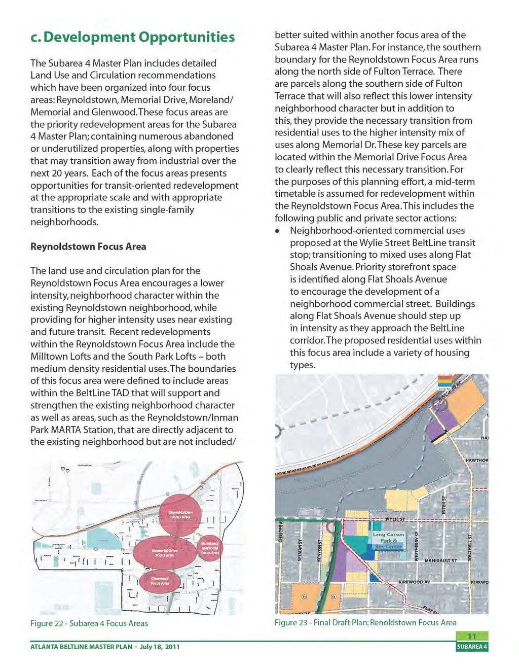
9 I. Executive Summary The recommendations of the Atlanta BeltLine Master Plan for Subarea 4 are summarized in the following pages. The recommendations include brief sections on land use, design, mobility, and parks. Complete recommendations follow this section in the Plan Recommendations Report. a. Study Overview The Atlanta BeltLine will combine greenspace, trails, transit, and new development along 22 miles of historic rail segments that encircle the core of the city. It will connect 45 neighborhoods and affect more than 100,000 people who live within one-half mile of the corridor. In 2005, the Atlanta City Council adopted the BeltLine Redevelopment Plan. This important planning document created a broad vision for the Atlanta BeltLine project and enabled the creation of the BeltLine Tax Allocation District (TAD), a key source of implementation funds. The Subarea 4 Master Plan builds on the foundation of previous planning efforts by refining recommendations and project lists via an expanded community input process. This process integrates land use, urban design, circulation, mobility, greenspace, and public art into a comprehensive master plan for one of ten subareas along the 22-mile Atlanta BeltLine. This Master Plan includes the following purposes: To update and refine Atlanta BeltLine-related planning efforts, taking into account recent development activity and relevant planning studies. To review the land use plan and circulation plan included in the 2005 BeltLine Redevelopment Plan in combination with other land use plans previously completed for the subareas and finalize the land use to be incorporated into the Comprehensive Development Plan. To review and refine the new street recommendations for incorporation in the Street Framework Plan and implementation through the BeltLine Overlay Zoning District. To better define streetscape, pedestrian and roadway projects and associated cost estimates for high priority corridors necessary to support future development as identified in the Redevelopment Plan and Street Framework Plan. To refine projects and programming related to parks and open spaces along the BeltLine. Upon completion of all Subarea Master Plans, Atlanta BeltLine Inc. will develop a comprehensive Implementation Plan and budget for projects identified and prioritized in individual subareas. This phased process will ensure a uniform approach to implementing projects and an equitable distribution of development across all geographies of the Atlanta BeltLine over time regardless of the sequencing of Subarea Master Plans. Master Plans by their nature are subject to periodic review and changes to reflect changing local conditions, refined neighborhood visions and city policies, demographic shifts, and other factors. This plan has been developed for the year 2030 based on a variety of data including projections of population and employment growth, economic conditions, and travel patterns and behaviors, as well as existing physical constraints and opportunities. Accordingly, from time to time, with appropriate community and technical input, this plan may be revisited and adjusted. ATLANTA BELTLINE MASTER PLAN July 18, 2011 Figure 01 - BeltLine Subareas i
10 b. Subarea Context Subarea 4 is located in the southeastern portion of Atlanta BeltLine, east of I-75/I-85 and bisected by I-20. It is bounded by DeKalb Avenue to the north, Moreland Avenue to the east, and Berne Street to the south (see Figures 1 and 2). The study area is centered on the Atlanta BeltLine corridor and generally includes the land within one-half mile of either side. The study area encompasses over 1,200 acres and includes 415 acres of the BeltLine Tax Allocation District. Subarea 4 incorporates several Neighborhood Planning Units (NPUs), City Council Districts, and neighborhoods, including portions of: Southeast Study Group. NPUs N, O, and W. City Council Districts 1 and 5. Neighborhoods of Cabbagetown, Capital Gateway, Edgewood, Grant Park, Ormewood Park, and Reynoldstown. The study area includes four significant redevelopment focus areas containing numerous abandoned or underutilized properties, along with properties that may transition away from industrial over the next 20 years. Each of the focus areas presents opportunities for transitoriented redevelopment at the appropriate scale and with appropriate transitions to the existing single-family neighborhoods. A synopsis of the recommendations for each focus area begins on page 11. Subarea 4 includes two major physical barriers: Interstate 20 and the CSX Hulsey Yard intermodal transfer facility. Both present challenges for connectivity and require special attention around their edges from land use, mobility, air quality and noise pollution perspectives. Figure 02 - Subarea 4 Context Map ii EXECUTIVE SUMMARY
11

12 c. Methodology and Community Input The Subarea 4 Master Plan was developed with input from the Southeast Study Group, Office Hours, Quarterly Briefing updates, the BeltLine.org website, and a Planning Committee established exclusively to review and guide this study. Utilizing a series of planning committee meetings and four study group meetings (public meetings) at key points in the process, community members and stakeholders had the opportunity to shape both the goals of and the recommendations for the Subarea 4 Master Plan. Community feedback, in addition to detailed existing conditions, identified opportunities, challenges, and recommendations from previous studies, which led to the development of two alternative concept plans. Through the refinement of these two concepts into a single draft, the Subarea 4 Master Plan integrates the community goals and principles of placemaking into its recommendations for land use and urban design, circulation and mobility, and greenspace and public art. Establishing Goals at Study Group Meeting iv d. Overview of Subarea Goals The Subarea 4 Master Plan centers on the principles of placemaking which include well balanced elements, appropriate scale and quality design. The community goals for Subarea 4, refined by the Planning Committee and validated by the Study Group, are organized by the three plan elements: (1) land use and urban design, (2) circulation and mobility, and (3) greenspace and public art. Throughout the planning process, the continual integration of both the principles of placemaking with the community s goals ensured a master plan solution that outlined future growth for the study area in a manner that is appropriate, aesthetic, economical and sustainable. The Subarea 4 goals are as follows: Land Use and Urban Design Goals Encourage a variety of uses at appropriate locations within the subarea to support future transit, promote reuse of historic properties, facilitate economic growth and improve community health. Promote development that supports and serves the needs of the neighborhoods - such as day-to-day services, housing and employment, community facilities (post office, library, community centers), and institutions (schools, medical facilities) - at a scale and intensity commensurate with community values and future needs. Retain the rich diversity and distinct character of the community through quality architecture, design cohesiveness of streetscapes and a variety of civic spaces. Strengthen the subarea s identity as a series of neighborhoods and marketplaces offering housing choices, employment diversity and recreational opportunities for all ages. Circulation and Mobility Goals Provide compatibility, connectivity and continuity in community-wide transportation solutions for all modes of travel through innovative strategies that also protect the character and integrity of the neighborhoods. EXECUTIVE SUMMARY

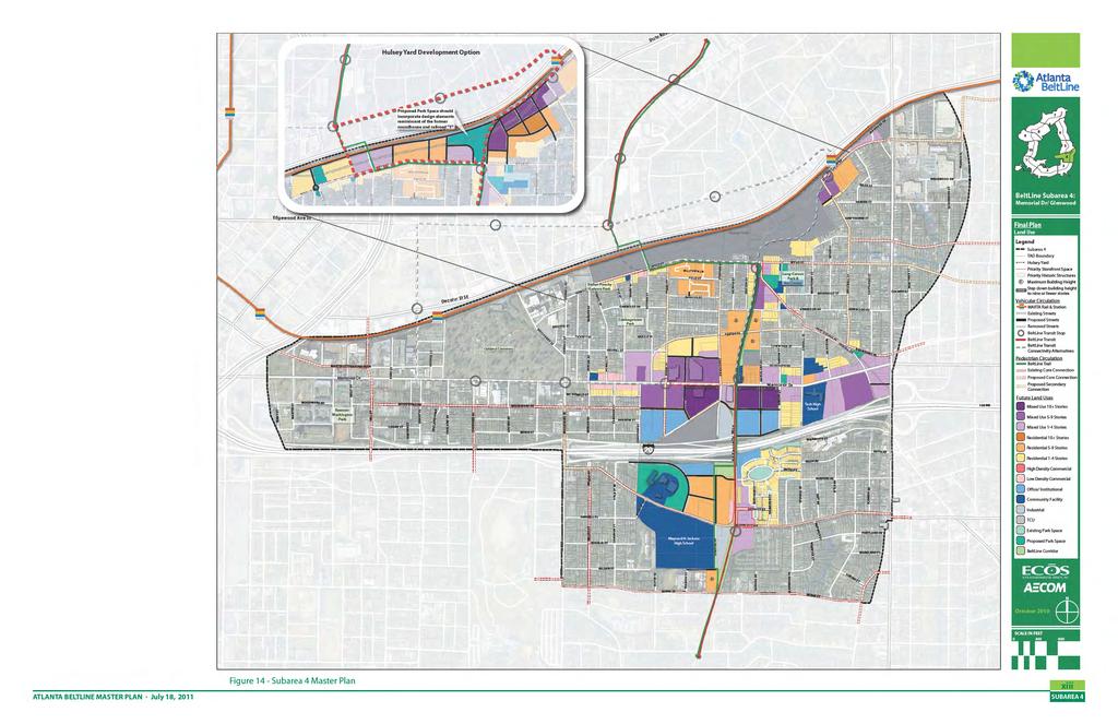
13 Provide a safe, efficient and continuous network of pedestrian and bicycle facilities as part of all planned streetscape and roadway improvements for improved access to transit and better health of the community. Maintain and improve traffic flow along the major thoroughfares of Memorial Drive, Moreland Avenue, Boulevard and DeKalb Avenue, while employing appropriate safety measures, improving accessibility to local businesses, and meeting the parking needs of the community. Provide appropriate transitions to existing residential neighborhoods. Higher intensities are located around transit stations (to provide ridership and eyes on the BeltLine for improved safety) and along major corridors, with the recommendation that these heights and intensities gradually reduce, or step down when adjacent to or across from the existing single-family residential areas. Create smaller blocks within existing superblocks and reestablish former street connections, where appropriate. Greenspace and Public and Cultural Arts Goals Ensure the livability of the subarea by improving the accessibility and quality of parks, open spaces and recreational opportunities, enhancing streetscapes, preserving cultural and historic assets and integrating a public arts program. Provide diverse, open, cultural, and civic spaces to promote social interaction, celebrate local art, improve community health, and retain distinctive neighborhood character. e. Plan Summary: Land Use and Design The Subarea 4 Master Plan encourages a variety of uses that reflect community character through quality architecture, preservation of historic resources, open spaces and cohesive streetscape design, while providing the appropriate transitions to established neighborhoods. The master plan promotes connectivity and encourages safe, walkable pedestrian and vehicular networks. Key land use and design policies and strategies include: Encourage repurposing of historic structures without compromising the physical character of the resource to embrace and celebrate the subarea s unique character and historic contributions to the City of Atlanta. Recommend priority storefront spaces where appropriate to create a vibrant, walkable commercial corridors that facilitate economic growth and improve the vitality of the streetscapes. ATLANTA BELTLINE MASTER PLAN July 18, 2011 The following section, which is organized into four focus areas, illustrates specific development opportunities within the study area. Reynoldstown Focus Area The land use recommendations for the Reynoldstown Focus Area encourage a lower intensity, neighborhood character within the existing Reynoldstown neighborhood, while providing for higher intensity uses near existing and future transit. This includes the following public and private sector actions: Figure 04 - Reynoldstown Focus Area Land Use Plan v

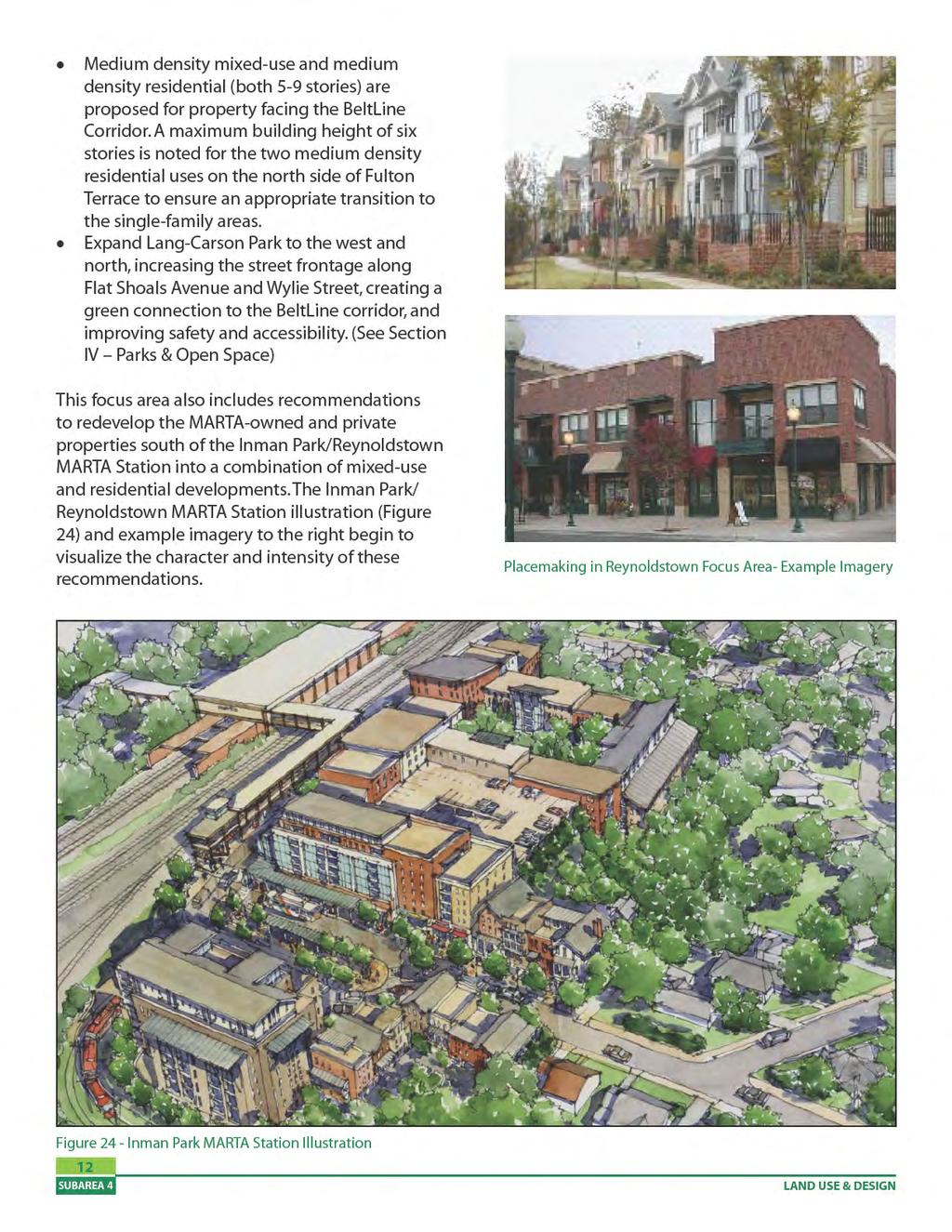
14 Identify priority storefront space along Flat Shoals Avenue to encourage the development of a neighborhood commercial street. Buildings on Flat Shoals should gradually increase in intensity as they approach the Atlanta BeltLine corridor. Redevelop the MARTA-owned and private properties south of the Inman Park/Reynoldstown MARTA Station into a combination of mixed-use and residential developments. Expand Lang-Carson Park to the west and north, increasing the street frontage along Flat Shoals and Wylie, creating a green connection to the Atlanta BeltLine corridor, and improving safety and accessibility. Memorial Drive Focus Area The land use recommendations for the Memorial Drive Focus Area identify higher intensity uses for properties fronting Memorial Drive and I-20 and lower intensity uses for those properties adjacent to the established single-family neighborhoods. The plan also recommends creating several blocks of high-quality storefront space along Memorial on the western side of Bill Kennedy Way. Redevelop abandoned and underutilized properties with office, mixed use, and residential developments. Break up large superblocks with new streets lined with parallel parking, street trees and sidewalks. Preserve and rehabilitate the historic industrial buildings along Memorial Drive. Restore the historic A&WP train depot, the last remaining railroad structure along the Atlanta BeltLine, as a transit station. This structure is large enough to accommodate an ancillary use such as a restaurant, newsstand, or civic use such as a visitor information center or museum. Identify priority storefront space along Memorial Drive between Pearl Street and Chester Avenue to encourage the development of a pedestrian-oriented retail corridor. Figure 05 - Inman Park/ Reynoldstown MARTA Station Illustration vi EXECUTIVE SUMMARY


15 Figure 06 - Memorial Drive Focus Area Land Use Plan Figure 07 - Memorial Drive Focus Area Illustration ATLANTA BELTLINE MASTER PLAN July 18, 2011 vii


16 MORELAND AVE Moreland/Memorial Focus Area Located at the intersection of Moreland Avenue and Memorial Drive, the land use recommendations focus on reconnecting the street grid and modifying the existing land uses so that the area may better function as a mixed-use node adjacent to the interstate. Provide for mixed-use, low density commercial, and some residential redevelopment around the intersection. Overhaul the intersection of Arkwright/ Memorial/I-20 and Moreland Avenue. If the existing LaFarge operation relocates, allow residential and office redevelopment and require the introduction of new streets while protecting the multi-use trail along Chester Avenue. Utilize the forest and school yard around the historic Atlanta Stockade as publicly accessible parkspace, leveraging its uniqueness as a cultural resource. MEMORIAL DR Figure 09 - Glenwood Station Area Plan Figure 08 - Moreland/ Memorial Focus Area Land Use Plan Glenwood Focus Area The land use recommendations for the Glenwood Focus Area support and enhance the existing retail uses at Glenwood Park by expanding residential, office, open space and community facility opportunities in the area. Identify priority storefront space at the intersection of Glenwood Avenue and Bill Kennedy Way to enhance the existing retail node at Glenwood Park. viii Existing LaFarge Property EXECUTIVE SUMMARY


17 Figure 10 - Glenwood Focus Area Land Use Plan Figure 11 - Glenwood Focus Area Illustration ATLANTA BELTLINE MASTER PLAN July 18, 2011 ix

 whether pedestrians, bicyclists,")
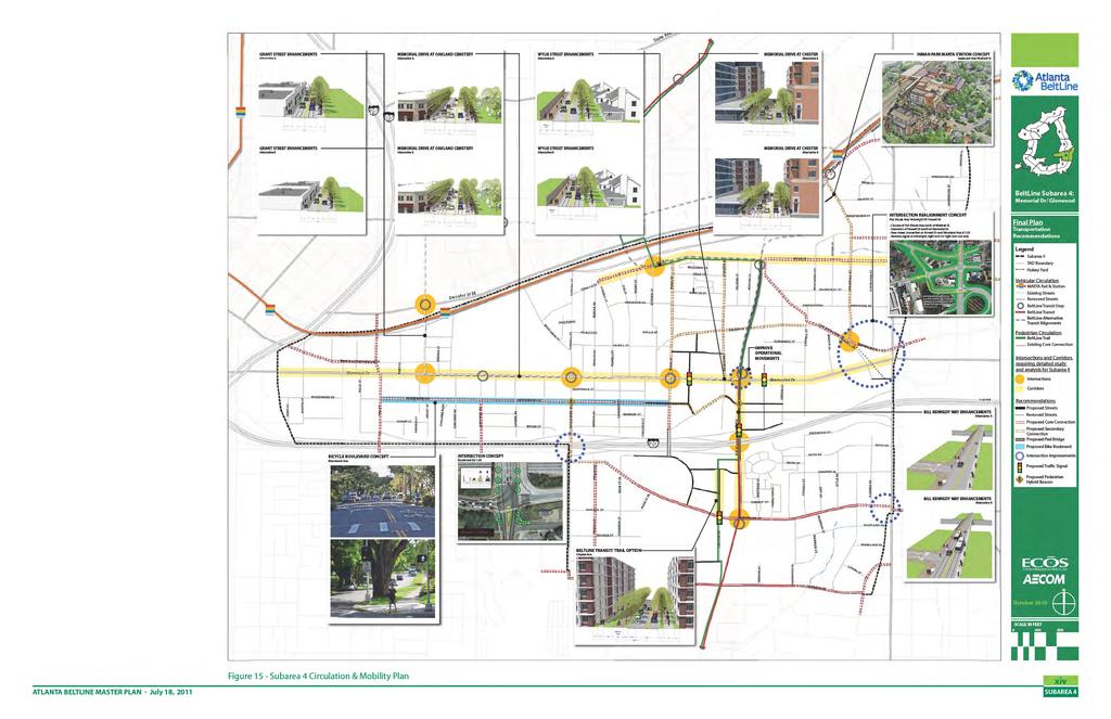
18 f. Plan Summary: Mobility Subarea 4 presents several opportunities to enhance mobility for future Atlanta BeltLine transit riders, bicyclists, pedestrians, and motorists. Central to the study area s future mobility is the BeltLine transit and trail. Additional tools include new pedestrian projects, new bicycle projects, developer-built streets, publicly-built streets, road diets and intersection improvements. All of the roadway recommendations are centered on the principles of Complete Streets, providing multimodal opportunities for all users (of all ages and abilities) whether pedestrians, bicyclists, transit users, or motorists within the right-of-way. Key recommendations are mapped in Figure 15 and summarized below: Improve traffic flow along major thoroughfares while employing appropriate safety measures and achieving mobility for all users. The recommendation to repurpose Memorial Drive via a road diet allows for a broader balance of travel modes and street functions, especially expansion of sidewalk and streetscape envelope, within Memorial Drive s constrained right-of-way. The road diet is also intended to reduce traffic speeds, create a safer pedestrian environment, and allow for improvements such as wider sidewalks or the addition of a landscaped buffer from traffic. Enhance connectivity within the existing street framework and provide new street networks. Through the recommended realignment/ modification of the Flat Shoals Avenue, Howell Drive and Arkwright Place intersection and new streets within the redevelopment of the larger parcels along Memorial, the Subarea 4 Master Plan will provide compatibility, connectivity and continuity for all modes of travel. Improve access to existing MARTA transit. The BeltLine transit and trail will greatly expand access to the MARTA rail system. Additionally, the plan recommends reconnecting Walthall Street to Seaboard Avenue (as it existed historically) south of the Inman Park/ Reynoldstown MARTA Station and creating a new pedestrian exit from the MARTA skywalk to Seaboard Avenue to shorten the walking distance to the Edgewood Retail District shopping center. Provide a safe, efficient and continuous network of pedestrian and bicycle facilities. Improving mobility for the non-motorist to and from the BeltLine corridor and community amenities will be met through the plan s recommendation of a hierarchy of core and secondary bicycle routes, sidewalk, streetscape, and multi-use trail projects. Specifically, Woodward Avenue is identified as a Bicycle Boulevard, allowing bicyclists a wider, safer east-west route through the study area. Use of innovative strategies in the subarea s infrastructure that offer multiple benefits, reduce cost and protect the character and integrity of the neighborhoods. Incorporation of green street strategies, where identified in the Subarea 4 Master Plan, provides the opportunity for the conventional grey infrastructure to manage stormwater through more sustainable, impact-conscious design methods that will reduce costs and enhance the aesthetics of the subarea. x Figure 12 - Proposed Memorial Drive Road Diet Diagram EXECUTIVE SUMMARY
.")
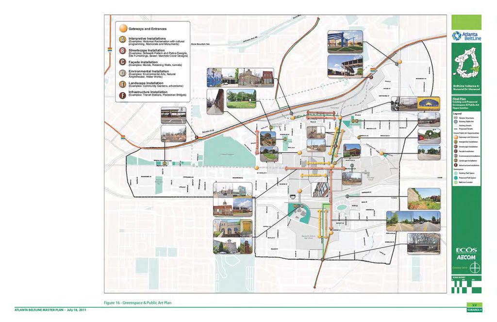
19 g. Plan Summary: Parks and Open Space The Subarea 4 Master Plan includes a variety of open space opportunities, which build on the existing and planned greenspaces in the study area (See Figure 16- Greenspace & Public Art Plan). These recommendations help provide diverse open, cultural, and civic spaces to promote social interaction, celebrate local art, improve community health, and strengthen the area s distinctive character. Key parks and open space recommendations include: The Atlanta BeltLine corridor will add 7.4 acres of greenway to the study area. This includes the section from Berne Street to Glenwood Avenue and from Memorial Drive to Wylie Street. The corridor will ultimately have a portion allocated for transit, with the majority dedicated to the multi-use trail, landscaping, and pocket parks. Lang-Carson Park, a former school building and school yard turned community center and neighborhood park, is one of two city parks in Reynoldstown. The other city park, known as Manigault Street Playlot, is a 0.22 acre lot that shares a property line with Lang-Carson Park. Presently, Lang-Carson Park has minimal street frontage, with equally poor visibility and sight lines. The master plan recommends the expansion of Lang-Carson Park through the acquisition of key parcels along its northern and western borders. The proposed acquisitions will greatly increase visibility, safety and recreation opportunities, and will create a continuous connection between the BeltLine corridor and the park. The acquisitions will add approximately 1.4 acres of useable area, increasing the park to nearly five acres. The Department of Watershed Management owns a two-acre parcel on Holtzclaw Street. The property once housed a water tower and a replacement water tower is planned. The property has spectacular views of Downtown and Midtown. Full public access to the site is unrealistic because of the planned water tower. The master plan, however, recommends a pedestrian connection between Holtzclaw Street and the BeltLine corridor, along with an overlook and seating area. The ten-acre Atlanta Stockade site was identified during the process as a jewel within the subarea. The master plan recommends incorporating a public park into the community facility leveraging its panoramic views, existing tree cover, historic school yard area, and unique architecture. Several redevelopment sites are large enough to include private parkspace, similar to those incorporated into the Glenwood Park development. Figure 16 also includes a public art plan, which identifies locations and types of public art well suited to the study area. These recommendations advance the BeltLine Cultural Planning Vision prepared in ATLANTA BELTLINE MASTER PLAN July 18, 2011 Figure 13 - Proposed Lang-Carson Park Expansion in Reynoldstown Neighborhood xi
20
21
22
23
24
25
26
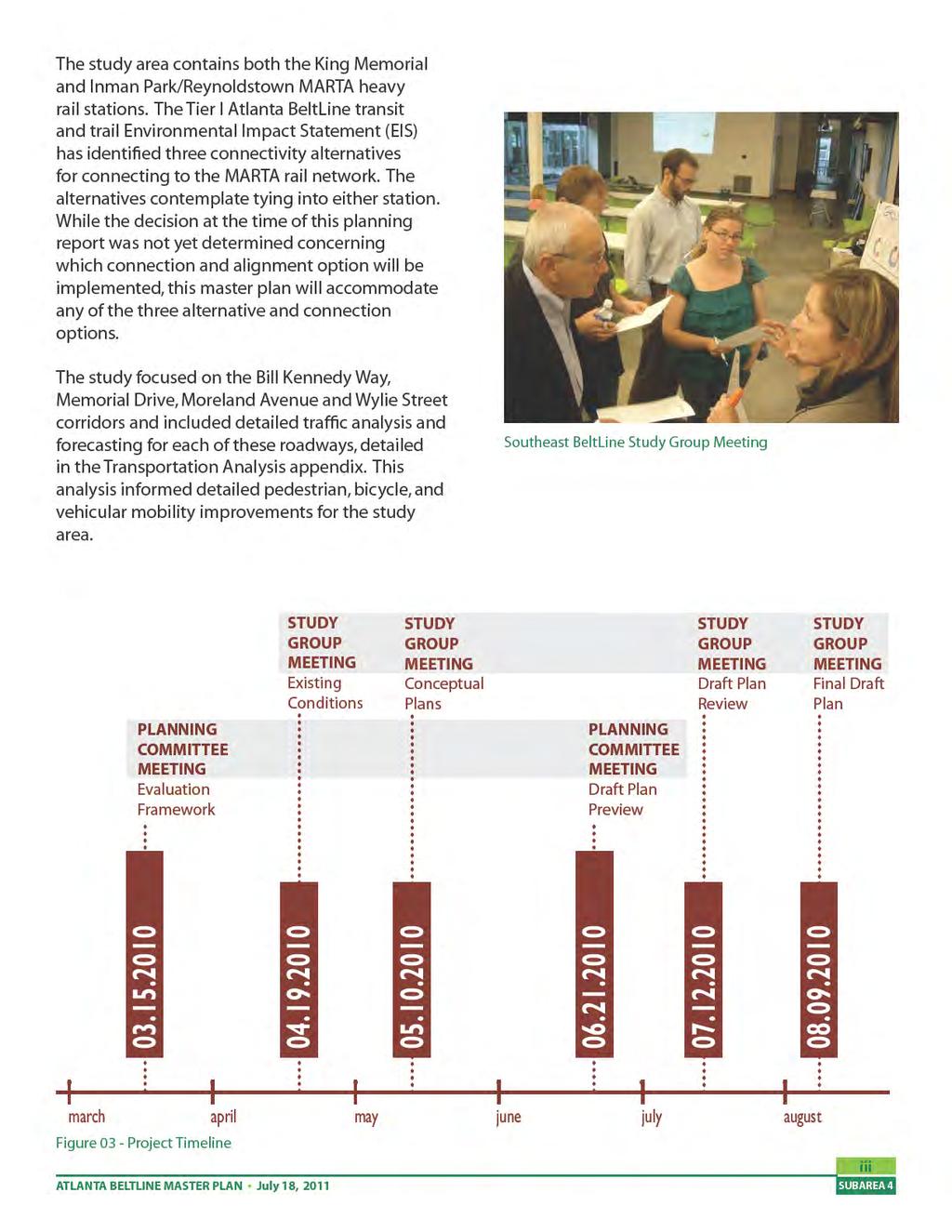
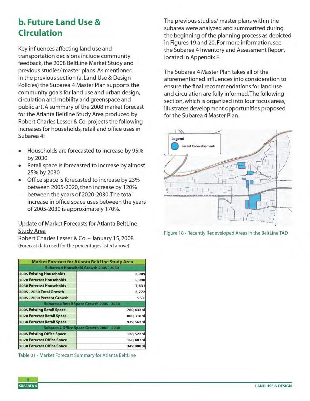
27 I. Overview a. Background The Atlanta Beltline will provide a network of public parks, multi-use trails and transit along a historic 22-mile railroad corridor circling downtown and connecting 45 neighborhoods. Due to the size, scale and unique character of each neighborhood, the BeltLine has been divided into ten different subareas for master planning. The Subarea 4 master planning process integrates land use and urban design, circulation and mobility, and greenspace and public art to complete a comprehensive master plan and 5 year implementation strategy for one of ten subareas along the 22-mile BeltLine. The Subarea 4 Master Plan builds on the foundation of previous BeltLine planning efforts; refining recommendations; identifying projects and programming related to parks, open space, mobility, circulation and land use; and providing the concept work to support future, more detailed design/engineering of nearterm projects. Subarea 4 is located in the southeast portion of Atlanta, east of I-75/I-85 and bisected by I-20. It is bounded by DeKalb Avenue to the north, Moreland Avenue to the east, and Berne Street to the south. It encompasses over 1,200 acres and includes the neighborhoods of Cabbagetown, Capitol Gateway, Edgewood, Grant Park, Ormewood Park and Reynoldstown. While the BeltLine has the potential to enhance and connect the neighborhoods within Subarea 4, there are many opportunities and challenges that currently exist. These opportunities and challenges were addressed specifically through a nine month planning process that focused on redevelopment and rehabilitation of the industrial and vacant land dominating the Tax Allocation District. Utilizing a series of planning committee meetings and four study group meetings (public meetings) at key points in the process, community members had the opportunity to provide feedback and shape the goals and recommendations in the Subarea 4 Master Plan. The Subarea 4 Master Plan incorporates the established community goals and principles of placemaking to provide recommendations, outlined in the following pages of this report, for land use and design, mobility and parks and open space. ATLANTA BELTLINE MASTER PLAN July 18,

28 2 Figure 17 - Subarea 4 Context Map OVERVIEW
29 b. Guiding Principles Placemaking The community goals for Subarea 4, reviewed and revised by the Planning Committee and validated by the Study Group, are organized by three plan elements: land use and urban design, circulation and mobility, greenspace and public art. The key to placemaking is to ensure these three elements are well-balanced, at the appropriate scale, and contain quality design that supports transit, as well as the community s goals. Subarea 4 Master Plan Goals Land Use and Urban Design Encourage a variety of uses at appropriate locations within the subarea to support future transit, promote reuse of historic properties, facilitate economic growth and improve community health. Promote development that supports and serves the needs of the neighborhoods - such as day-to-day services, housing and employment, community facilities (post office, library, community centers), and institutions (schools, medical facilities) - at a scale and intensity commensurate with community values and future needs. Retain the rich diversity and distinct character of the community through quality architecture, design cohesiveness of streetscapes and a variety of civic spaces. Strengthen the subarea s identity as a series of neighborhoods and marketplaces offering housing choices, employment diversity and recreational opportunities for all ages. Circulation and Mobility Provide compatibility, connectivity and continuity in community-wide transportation solutions for all modes of travel through innovative strategies that also protect the character and integrity of the neighborhoods. Provide a safe, efficient and continuous network of pedestrian and bicycle facilities as part of all planned streetscape and roadway improvements for improved access to transit and better health of the community. Maintain and improve traffic flow along the major thoroughfares of Memorial Drive, Moreland Avenue, Boulevard and DeKalb Avenue, while employing appropriate safety measures, improving accessibility to local businesses, and meeting the parking needs of the community. Greenspace and Public and Cultural Arts Ensure the livability of the subarea by improving the accessibility and quality of parks, open spaces and recreational opportunities, enhancing streetscapes, preserving cultural and historic assets and integrating a public arts program. Provide diverse open, cultural, and civic spaces to promote social interaction, celebrate local art, improve community health and retain their distinctive character. c. Project Implementation Summary After the adoption of all subarea master plans, Atlanta BeltLine Inc. will develop a comprehensive Implementation Plan and budget for projects identified and prioritized in the individual subareas. This phased approach will help ensure a uniform approach to implementing projects and an equitable distribution of development opportunities across all geographies of the BeltLine over time regardless of the sequencing of subarea master plans. ATLANTA BELTLINE MASTER PLAN July 18,
30 Implementation of projects identified in individual subarea master plans is dependent upon the active involvement of numerous organizations. Many of the projects are spearheaded and managed by Atlanta BeltLine, Inc. However, there is a variety of other programs and activities that are important for supporting healthy growth, and require the involvement of outside partners and stakeholders. These additional activities will be achieved with the leadership, collaboration, and resources of organizations with specialized expertise in these specific areas. Key areas of implementation include the following: 1. Developing and planning core BeltLine amenities in a way that enhances quality of life and distributes economic development in an equitable manner 2. Recruiting economic development in a way that creates business and job opportunities throughout the BeltLine 3. Minimizing displacement and leveraging economic opportunity in a way that stabilizes neighborhoods 4. Incorporating community voice in project implementation 5. Preserving and enhancing the historic and cultural character of neighborhoods The Implementation Plan will distinguish between the activities within ABI s control and those outside ABI s control, in which other organizations will help to achieve BeltLine objectives. The extent of ABI s control, and therefore the extent of ABI s leadership and leverage during implementation, has been categorized into three classifications: ABI Control: Projects that ABI is responsible for based on legislative authority and the use of flexible TAD funds. ABI Influence: Projects that are primarily controlled by outside parties with some ABI involvement and/or nominal TAD funding or adherence to BeltLine design standards. External ownership: Projects that require external leadership and ownership in order to most effectively achieve equitable development. The Implementation Plan will assign each project from the subarea master plans to one of the classifications detailed above. ABI will then work with its various external partners to implement and promote the forward movement of the BeltLine vision. 4 OVERVIEW
31 II. Land Use & Design a. Land Use & Design Policies To ensure the Subarea 4 Master Plan meets the community s goals and the principles of placemaking, it is imperative that community feedback be incorporated throughout the planning process. To better facilitate concerns and comments, the master plan was categorized into four focus areas which allowed the community to provide feedback on (1) land use and urban design, (2) circulation and mobility, (3) greenspace and (4) public art. This community feedback, from the discovery phase of reviewing existing conditions and previous studies, to the initial design phase of alternative concept plans, and through to the Draft and Final Draft Master Plans, has allowed the Subarea 4 Master Plan to incorporate recommendations and policies that reflect community values. The Subarea 4 Master Plan encourages a variety of uses that reflect community character through quality architecture, incorporation of historic resources, open spaces and cohesive streetscape design, while providing the appropriate transitions to established neighborhoods. The master plan promotes connectivity and encourages safe, walkable pedestrian and vehicular networks. Land Use and Design policies/strategies for Subarea 4 include: Encourage repurposing of historic structures without compromising the physical character of the resource. An example includes recommending the reuse of the historic A&WP train depot as a BeltLine transit stop. The depot is also large enough to accommodate an ancillary use such as a restaurant or a BeltLine visitor information center. ATLANTA BELTLINE MASTER PLAN July 18, 2011 Recommend priority storefront spaces where appropriate to create a vibrant, walkable commercial corridor that facilitates economic growth. A few key areas have been identified within Subarea 4 as appropriate for storefronts, although the scale would vary based on land use and community character. Areas identified for storefronts include mixed-use parcels along Flat Shoals Avenue near the proposed BeltLine transit stop at Wylie Street, mixed-use parcels at the intersection of Glenwood Avenue and Bill Kennedy Way and parcels along Memorial Drive from Pearl Street to Chester Avenue. Provide appropriate transitions to existing residential neighborhoods. Higher intensities are located around transit stations and along major corridors, stepping down building heights approaching single family residential and proposing lower intensity land uses for parcels adjacent to single family areas. While the master plan incorporates this strategy throughout the subarea, the uses and intensities recommended along Memorial Drive provide a clear example of this policy. Create an interconnected street network by proposing smaller blocks within existing superblocks and reestablishing former street connections where appropriate. Specific examples can been seen with the proposed reconnection of Walthall Street at the Inman Park/Reynoldstown MARTA station as well as the proposed street network within existing superblocks along Memorial Drive and Glenwood Avenue. Improve the quantity and quality of parks, open spaces and recreational opportunities within the subarea. While the lack of viable, large land parcels for new park space within existing neighborhoods creates a challenge, the master plan proposes a variety of open space types at varying scales throughout the subarea. Specifically, the master plan recommends the expansion of the existing Lang-Carson Park, a proposed park/ community facility at the historic Atlanta Stockade property in addition to the BeltLine Corridor as a transit and trail greenway. 5
32


33 Figure 19 - Previous Studies: Land Use Figure 20 - Previous Studies: Transportation ATLANTA BELTLINE MASTER PLAN July 18,
34
35
36
37
38
 Proposed reconnection of Walthall Street will provide better access to the existing residential neighborhood to the south.")
39 To provide a variety of uses within close proximity to transit, medium density mixeduse and medium density residential uses are proposed adjacent to the station. (LU-4) Proposed reconnection of Walthall Street will provide better access to the existing residential neighborhood to the south. Enhanced pedestrian wayfinding is recommended along Seaboard Avenue to the MARTA Station, primarily to provide better transit access to Moreland Avenue and the Edgewood Retail District. A new MARTA Station pedestrian entrance is proposed at Seaboard Avenue, east of existing entrance. This new entrance is recommended as a staircase only. Recommend mixed-use and residential building heights along Seaboard Avenue and the new extension of Walthall Street of 5 to 9 stories, stepping down to 4 or fewer stories next to single-family residences. The plan does not recommend any changes to the Cabbagetown Landmark District along Wylie Street. Memorial Drive Focus Area The land use and circulation plan for the Memorial Drive Focus Area identifies higher intensity uses for properties fronting Memorial Drive and I-20 and lower intensity uses for those properties adjacent to the surrounding singlefamily neighborhoods. Recent redevelopments within the Memorial Drive Focus Area include the A&P Lofts, Triumphs Lofts, 920 Memorial Dr (a residential condo development) and the Trees Atlanta Office. While many of the recent redevelopments are residential in nature, a mix of uses at higher intensities is needed to support the proposed BeltLine transit stop at the intersection of Memorial Drive and Bill Kennedy Way. The Memorial Drive Focus Area is bounded by Fulton Terrace to the north, Berean Street to the west, I-20 to the south and Stovall Street to the east. The boundaries of this focus area were defined to include parcels within the BeltLine TAD that will support the higher intensity uses needed for transit in addition parcels that can provide the appropriate transition to surrounding singlefamily neighborhoods. Figure 25 - Final Draft Plan: Memorial Drive Focus Area ATLANTA BELTLINE MASTER PLAN July 18,


40 Figure 26 - Memorial Drive Station Area Plan 14 Figure 27 - Memorial Drive Illustration LAND USE & DESIGN

41 The land use and circulation recommendations have been categorized below from west to east, with north-south street names used as general boundaries. The Memorial Drive Station Area Plan, illustration and example imagery on the following pages begin to visualize the character, intensity, building configurations of these recommendations. For the purposes of this planning effort, a short-term and mid-term timetable is assumed for redevelopment within the Memorial Drive Focus Area. Berean Street to Pearl Street Along Memorial Drive, this western section of the BeltLine Tax Allocation District (TAD) is partially within the Cabbagetown Landmark District and the SPI-22 zoning district. The plan recommends that the proposed land use and circulation concepts for this area encourage the development of mixed-use, residential and commercial uses. This mix of uses should utilize pedestrian oriented building forms, re-use and rehabilitation of historic structures (or facades when appropriate) and provide appropriate transitions between new development along Memorial Drive and established residences to the north and south. Starting at Berean Street and moving east, low density commercial use along Memorial Drive adheres to the existing use and scale in this area. Appropriate transitions are recommended for parcels adjacent to existing residential. Once reaching Chastain Street the intensity of uses is increased due to proximity to proposed BeltLine transit and support by the community. North of Memorial Drive, low density mixeduse conforms to the Cabbagetown Landmark District Regulations. Due to maximum building heights and setback regulations within the Cabbagetown Landmark District, only a portion of this block facing Memorial Drive is recommended as medium density mixed-use. Existing single family residential between Estoria Street and Pearl Street to remain. Proposed low density commercial use of storefront building at the intersection of Estoria Street and Gaskill Street. Improve the underutilized grass median at this intersection to function as a gateway for the Cabbagetown neighborhood. Pearl Street to Chester Avenue The goals for land use and urban design for Subarea 4, which were reviewed, revised and validated by the Planning Committee and Study Group include, encouraging a variety of uses at appropriate locations supporting future transit, promoting reuse of historic properties, facilitating economic growth and improving community health. This portion of Memorial Drive provides the opportunity to achieve these goal established for Subarea 4. Mixed-use development along Memorial Drive should encourage re-use of existing historic structures without compromising the physical character of the resource and provide new street network to create smaller blocks, while providing the appropriate transition between higher intensity development and the established single-family residences to the north. This transition is symbolized on the master plan for high intensity mixed-use areas; requiring a step down to nine or fewer stories along Memorial Drive. Priority storefronts are identified along this section of Memorial Drive to encourage the development of a walkable, mixed-use/ retail corridor. Memorial Drive Focus Area- Example Imagery ATLANTA BELTLINE MASTER PLAN July 18,
42 Mixed-use and Office/ Institutional on the southern portion of Memorial Drive are recommended adjacent to I-20 and the City of Atlanta Telecommunication Tower. The plan recommends that parking structures for the parcels adjacent to I-20 and the telecommunications tower front Old Flat Shoals Road. Chester Avenue to Gibson Street At the center of Subarea 4, the intersection of Memorial Drive and Bill Kennedy Way is part of a direct route to downtown Atlanta with easy access to I-20 west. This area also includes a proposed stop for BeltLine transit and is one of three crossings of I-20 in the subarea. A key recommendation of the Subarea 4 Master Plan is use of the historic A&WP train depot as a BeltLine transit stop. The depot is large enough to accommodate an ancillary use such as a restaurant or BeltLine Visitor Center. As the only remaining structure associated with the railroad along the BeltLine, the train depot provides a unique opportunity for adaptive re-use which is reminiscent of its historic function. It also supports the preservation of a cultural and historic asset in addition to providing an interpretive opportunity to represent the history of the BeltLine. Several parcels within this area have been recently redeveloped and are proposed to remain. These recent redevelopments include the A&P lofts which are shown as mixed-use due to live/work opportunities, the Triumph Lofts located on the west side of the depot and the townhomes at 920 Memorial Drive located directly east of the depot. The industrial parcel just south of the A&P lofts which is utilized by GDOT is recommended to remain. The remaining parcels north of Memorial Drive, with the exception of the City of Atlanta Watershed Management property on Holtzclaw Street, are proposed as residential uses fronting the BeltLine, stepping down in building height to transition into the existing neighborhood fabric and mixed-use along Memorial Drive. The City of Atlanta Watershed Management property on Holtzclaw Street is intended to remain a city property and provide a location for water storage in the future. Although this property cannot have full public access, the Subarea 4 Master Plan proposes a public access path along the northern boundary of the property from Hotlzclaw Street to an overlook structure providing views of the BeltLine Corridor and Downtown Atlanta. The Reynoldstown Civic Improvement League and NPU-N have recommended the parcel for a future park space. The remaining parcels south of Memorial Drive provide another opportunity for higher intensity mixed-use and office/ institutional, creating new street networks and smaller redevelopment blocks while providing the appropriate transition between higher intensity development and the established single-family residences to the north. This transition is symbolized on the master plan for high intensity mixed-use areas, requiring a step down to nine or fewer stories along Memorial Drive. Gibson Street to Stovall Street Located between two major intersections along Memorial Drive, this area proposes a lower intensity of uses which preserve existing residential neighborhoods to the north and south while encouraging a mix of uses along the corridor. The master plan also suggests expansion of the existing Wonderoot community garden at Gibson Street and Memorial Drive as an interim use of the adjacent vacant parcels until redevelopment occurs. 16 LAND USE & DESIGN


43 MORELAND AVE Moreland/Memorial Focus Area The land use and circulation plan for the Moreland/Memorial Focus Area include several street grid reconnections and modifications which allow this area to function better as a mixed-use center adjacent to the interstate. The Moreland/ Memorial Focus Area includes all the parcels to the east of Stovall Street within the BeltLine TAD. Stovall Street is a logical boundary line between the Memorial Drive Focus Area and the Moreland/ Memorial Focus Area due to the relative distance of its location from the proposed BeltLine transit stop at Memorial Drive and Bill Kennedy Way to the west and the intersection of Moreland Avenue and Memorial Drive to the east. Additionally, the existing institutional uses along the east side of Stovall Street, both north and south of Memorial Drive are slated to remain, which further divides the focus of areas for redevelopment. The Moreland/Memorial Focus Area, which is not located within close proximity of the proposed BeltLine transit but is adjacent to an interstate exit, has not seen any recent redevelopments. For the purposes of this planning effort, a long-term timetable is assumed for redevelopment within the Moreland/Memorial Focus Area. Mixed-use (1-4 stories) proposed along Memorial Drive with mixed-use (5-9stories) adjacent to I-20 and residential (1-4 stories) transitioning to the existing single-family neighborhood. Realignment/ modification of the Flat Shoals Avenue, Howell Drive and Arkwright Place street network (see Mobility section, pg 40 for more details). MEMORIAL DR Figure 28 - Final Draft Plan- Moreland/Memorial Focus Area Moreland/Memorial Focus Area - Example Imagery ATLANTA BELTLINE MASTER PLAN July 18,
44 Glenwood Focus Area The land use and circulation plan for the Glenwood Focus Area supports and enhances the existing retail uses at Glenwood Park by expanding residential, office, open space and community facility opportunities in the area. Recent redevelopments within the Glenwood Focus Area include Glenwood Park (a 28 acre mixed-use development) and a multi-family development at 880 Glenwood Ave. The Glenwood Focus Area is bounded by I-20 to the north and Berne Street to the south. The boundaries of this focus area were defined to include parcels within the BeltLine TAD that will enhance and support the existing retail and residential uses within the area. Several additional parcels just north of Berne Street that outside of the TAD, but currently being used by LaFarge for industrial purposes, are also identified within the Glenwood Focus Area. This area is a clear node of redevelopment potential surrounded by existing residential uses but for the purposes of this planning effort, a long-term timetable is assumed for redevelopment within the Glenwood Focus Area. Proposed BeltLine transit stop located just south of the Glenwood Avenue/ Bill Kennedy Way intersection. The transit stop will complement the low density mixed-use proposed south of Glenwood Avenue and strengthen the intersection as a mixed-use node. Priority storefronts are identified at Glenwood Avenue/ Bill Kennedy Way to encourage the development of a mixeduse/ neighborhood commercial node and to complement the existing storefronts located on the north side of Glenwood Avenue. The parcel located southwest at the Glenwood Avenue/ Bill Kennedy Way intersection, currently a concrete batch plant, is recommended to remain industrial. Office/Institutional uses are proposed directly south of I-20 within the existing LaFarge property and in the undeveloped portion of Glenwood Park just east of Bill Kennedy Way. The 880 Glenwood redevelopment, which is currently underway, will be a medium density residential development of approximately 5 stories. The property is bounded by Bill Kennedy Way on the east and the BeltLine trail which parallels the proposed extension of Chester Avenue on the west. Medium density residential is proposed for the majority of the LaFarge property, located just west of the BeltLine trail and Chester Avenue extension, providing a complementary density and use for both sides of the corridor. Built in 1896, the Atlanta Stockade was once the largest city-built penal complex in the State. The site contains the former prison, blacksmith shop and stables; all three are on the National Register of Historic Buildings. The site also includes The Arts Exchange building, which is not on the National Register, but is noted by the AUDC s Historic Resource Survey as a contributing non residential structure. These historic gems, hidden from street view with dense vegetation, are located on one of the highest points in the area, rising 50-feet above the Lafarge site to the east. The Subarea 4 Master Plan proposes that the forest and school yard around the historic Atlanta Stockade be utilized as publicly accessible parkspace, leveraging its uniqueness as a cultural resource while providing open space in a much needed location. 18 LAND USE & DESIGN


45 Glenwood Focus Area- Example Imagery Figure 29 - Final Draft Plan: Glenwood Focus Area ATLANTA BELTLINE MASTER PLAN July 18,


46 Figure 30 - Glenwood Avenue Station Area Plan Figure 31 - Glenwood Avenue Illustration 20 LAND USE & DESIGN
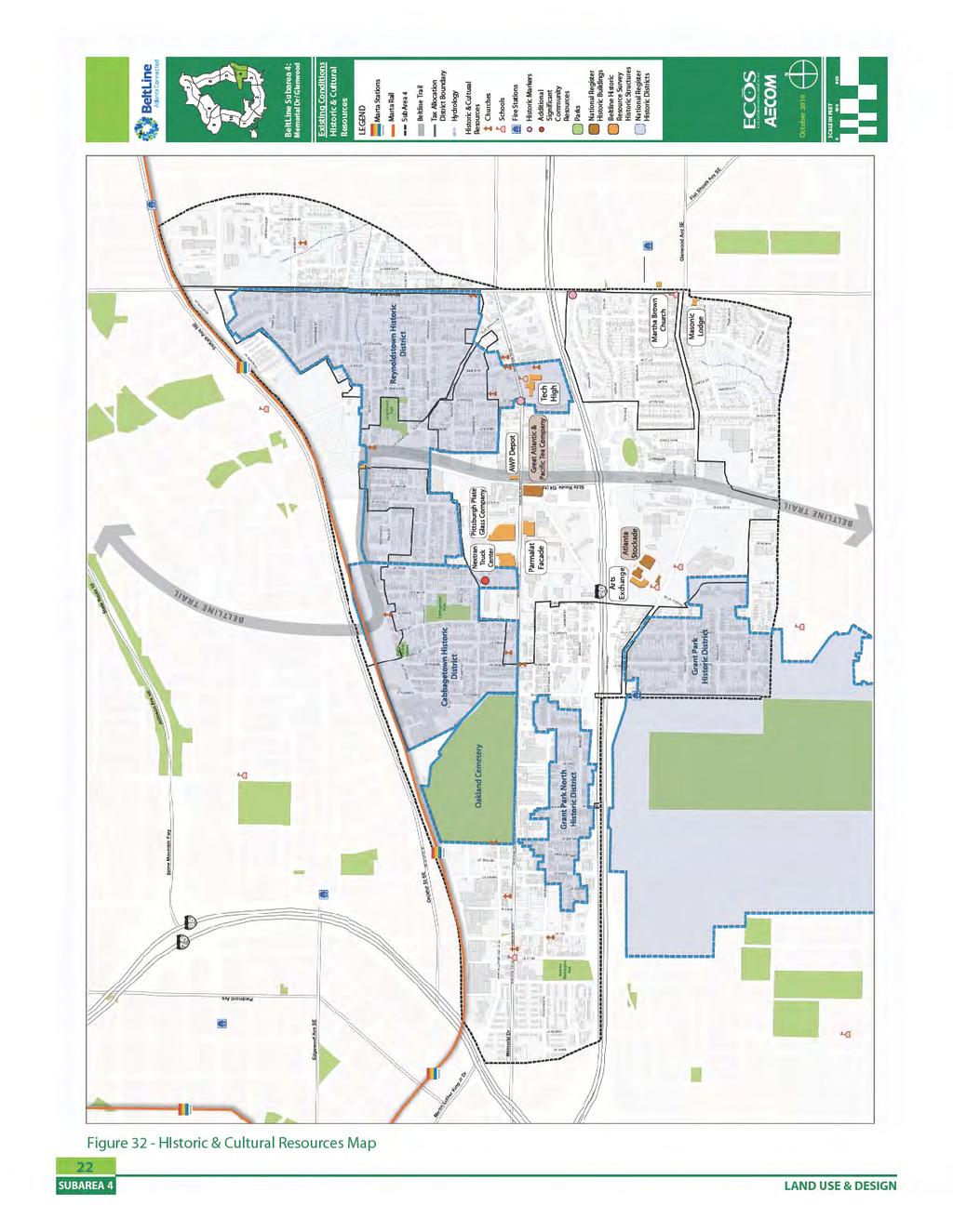
47 d. Historic Resources Strategies Historic and cultural resources are key to the preservation of character along the BeltLine Corridor. They also provide educational opportunities on the history of Atlanta, and more specifically within Subarea 4. There are a number of historic and cultural resources within Subarea 4, including historic neighborhoods, schools, churches and various structures such as the Atlanta Stockade and the Great Atlantic & Pacific Tea Company Building. The lists below show the nationally and locally designated historic features within the subarea. National Register of Historic Places: Buildings: Atlanta Stockade Great Atlantic & Pacific Tea Company Districts: Grant Park Historic District Grant Park North Historic District Cabbagetown Historic District Reynoldstown Historic District Oakland Cemetery Historic District Preliminary Findings by AUDC Staff of Significant Historic Resources within the BeltLine TAD The Atlanta Urban Design Commission (AUDC) conducted a survey of the entire BeltLine corridor titled Historic Preservation & the BeltLine. The mission of the AUDC survey is to integrate historic preservation into the (BeltLine) planning process and to identify historic resources (as) a key component of the BeltLine s future. From this comprehensive survey, a shorter list of priority historic resources was created to identify key features to be protected by the AUDC. Priority Historic Resources within the BeltLine TAD for Subarea 4 include: Buildings: Atlanta Stockade The Arts Exchange Great Atlantic and Pacific Tea Company Building Martha Brown United Methodist Church Masonic Grand Lodge Tech High Atlanta & West Point Depot Pittsburg Plate Glass Company Nextran Truck Center Parmalat Reynolds Store The Historic & Cultural Resources Map (Figure 32) displays the information described above, as well as the nationally and locally listed features. Other resources noted on the map include community facilities such as churches and schools within the area and additional structures identified during the planning process for potential recognition and protection. Future development and design within Subarea 4 should respect the existing historic structures and neighborhoods by preserving existing facades and/or overall structures while blending in with the existing neighborhood character and scale. ATLANTA BELTLINE MASTER PLAN July 18,
48


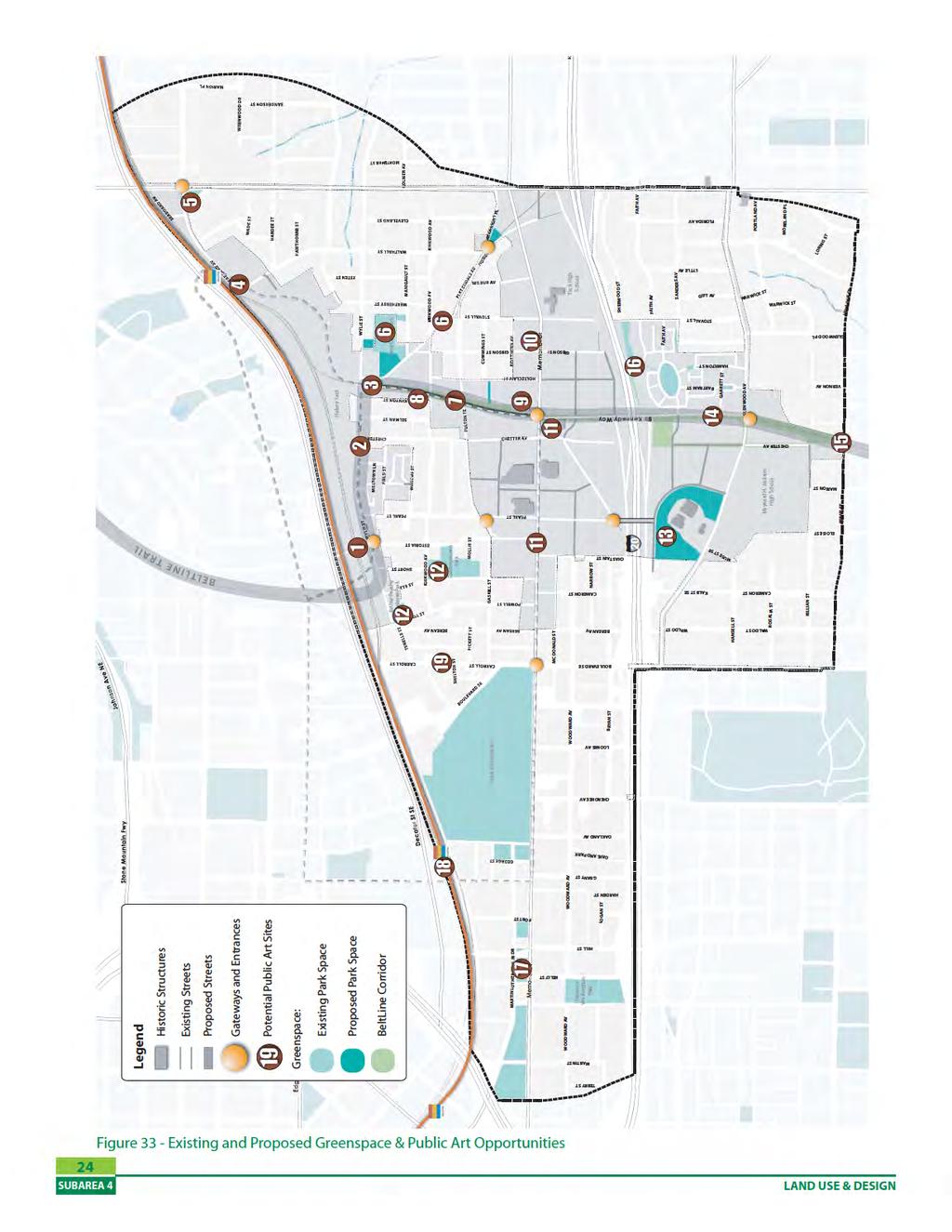
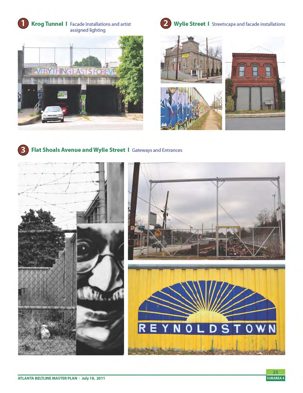
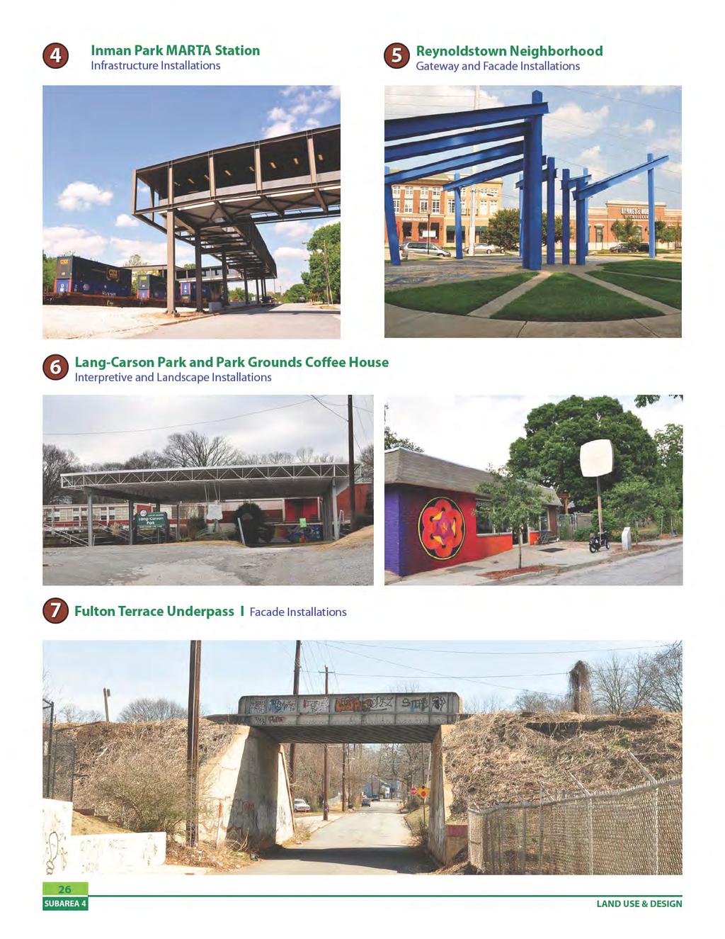
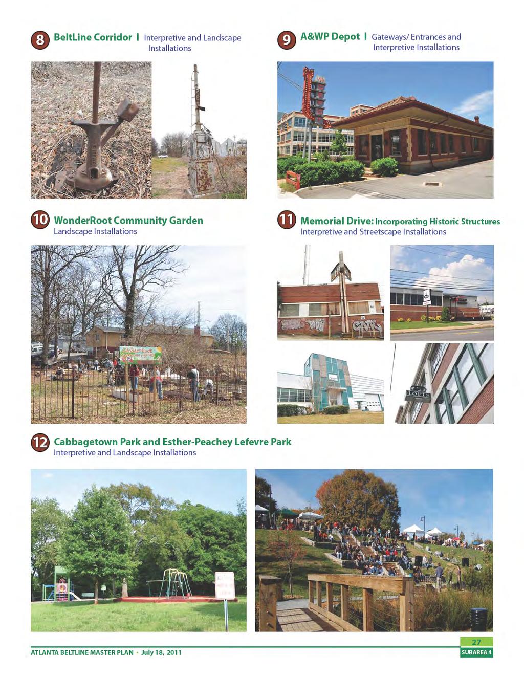
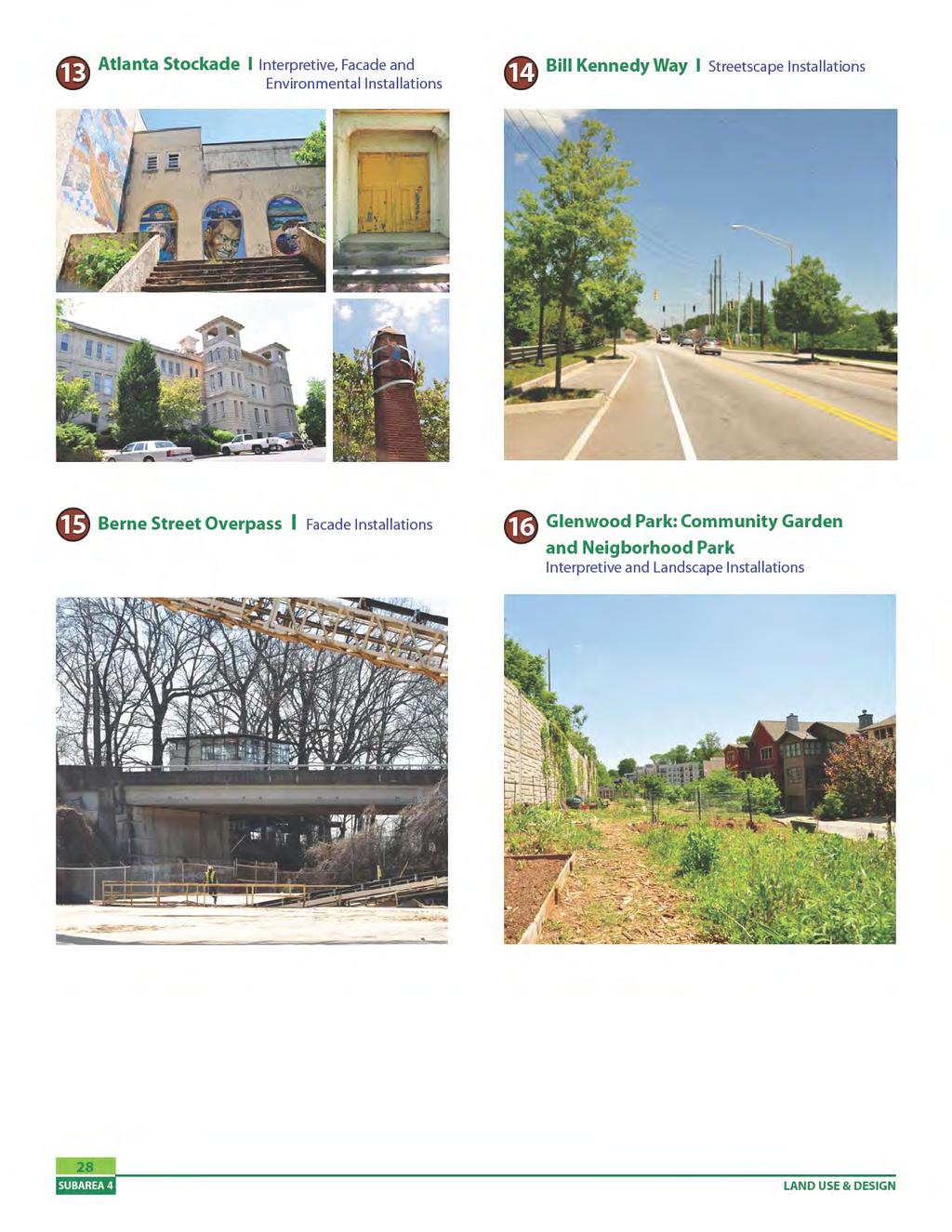
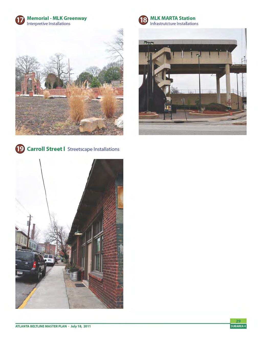
49 e. Art & Culture Strategies The arts and culture element of the Subarea 4 Master Plan builds upon the BeltLine Cultural Planning Vision (2006) as well as the community goals for greenspace and public art. The draft community goals, which were reviewed and revised by the Planning Committee and validated by the Study Group, include the following: Ensure the livability of the subarea by improving the accessibility and quality of parks, open spaces and recreational opportunities, enhancing streetscapes, preserving cultural and historic assets and integrating a public arts program. Provide diverse open, cultural, and civic spaces to promote social interaction, celebrate local art, improve community health and retain the distinctive character. With an understanding of the community desires, the example applications from the BeltLine Cultural Planning Vision were categorized into the following groups: Gateways and Entrances Interpretive Installations (Examples: historical reclamation with cultural programming, memorials and monuments) Streetscape Installations (Examples: sidewalk pattern and patina designs, site furnishings, sewer- manhole cover designs) Façade installations (Examples: murals, retaining walls, tunnels) Environmental Installations (Examples: environmental arts, natural amphitheater, water works) Landscape Installations (Examples: community gardens, arboretums) Infrastructure Installations (Examples: transit stations, pedestrian bridges) The Subarea 4 Master Plan incorporates gateways and public art installations striving to highlight existing art and significant features. The following is list of potential gateways and installations within Subarea 4. The numbers and descriptions below coincide with the numbered photographs on the Existing and Proposed Greenspace and Public Art Opportunities Map (Figure 33) Example of Interpretive Installation ATLANTA BELTLINE MASTER PLAN July 18, 2011 Example of Neighborhood Gateway 23
50
51
52
53
54
55
56 f. Project Implementation: Land Use Recommendations Summary Please refer to Appendix A: CDP Amendments for land use recommendations summary and map. 30 LAND USE & DESIGN
57 III. Mobility a. Mobility Policies Subarea 4 presents several opportunities to enhance mobility for future Atlanta BeltLine transit riders, bicyclists, pedestrians, and motorists. Central to the study area s future mobility is the BeltLine transit and trail. Additional tools include new pedestrian projects, new bicycle projects, developer-built streets, publicly-built streets, road diets and intersection improvements. All of the roadway recommendations are centered on the principles of Complete Streets, providing multimodal opportunities for all users (of all ages and abilities) whether pedestrians, bicyclists, transit users, or motorists within the right-of-way. The community goals for circulation and mobility for the Subarea 4 master plan, which were refined by the Planning Committee and validated by the Study Group, are listed below: Provide compatibility, connectivity and continuity in community-wide transportation solutions for all modes of travel through innovative strategies that also protect the character and integrity of the neighborhoods. Provide a safe, efficient and continuous network of pedestrian and bicycle facilities as part of all planned streetscape and roadway improvements for improved access to transit and better health of the community. Maintain and improve traffic flow along the major thoroughfares of Memorial Drive, Moreland Avenue, Boulevard and DeKalb Avenue, while employing appropriate safety measures, improving accessibility to local businesses, and meeting the parking needs of the community. b. Connectivity & Accessibility Improvements Overview Several challenges regarding mobility, connectivity and accessibility exist within Subarea 4. Two major physical barriers include Interstate 20 and the CSX Hulsey Yard intermodal transfer facility. The subarea also contains both the King Memorial and Inman Park/Reynoldstown MARTA heavy rail stations. The Tier I Atlanta BeltLine transit and trail Environmental Impact Statement (EIS) has identified three connectivity alternatives for connecting to the MARTA rail network. The alternatives contemplate tying into to either station. While the decision on which connection and alignment option gets built is still pending, this master plan was designed to accommodate any of the three alternatives. Despite these challenges, the Subarea 4 Master Plan suggests several opportunities for capital projects or policy changes that will enhance the community s connection to the BeltLine corridor, offer more mobility options and improve connectivity and accessibility overall. Below are the connectivity and accessibility improvements recommended for Subarea 4. Mobility projects listed below that are also included within the Project Implementation section of this chapter (pg 48) are noted with the Project ID in parenthesis. The complete Transportation Analysis Report is located in Appendix C. New Streets o Reconnection of Walthall Street to Seaboard Avenue, south of the Inman Park/ Reynoldstown MARTA Station. (NS-1) o Realignment/modification of the Flat Shoals Avenue, Howell Drive and Arkwright Place intersection includes: Howell Drive extension and connection to I-20/Moreland Avenue interstate ramps. (NS-2) Arkwright Place/ Moreland Avenue pedestrian-activated signal/crossing and right-in/ right-out configuration. ATLANTA BELTLINE MASTER PLAN July 18,
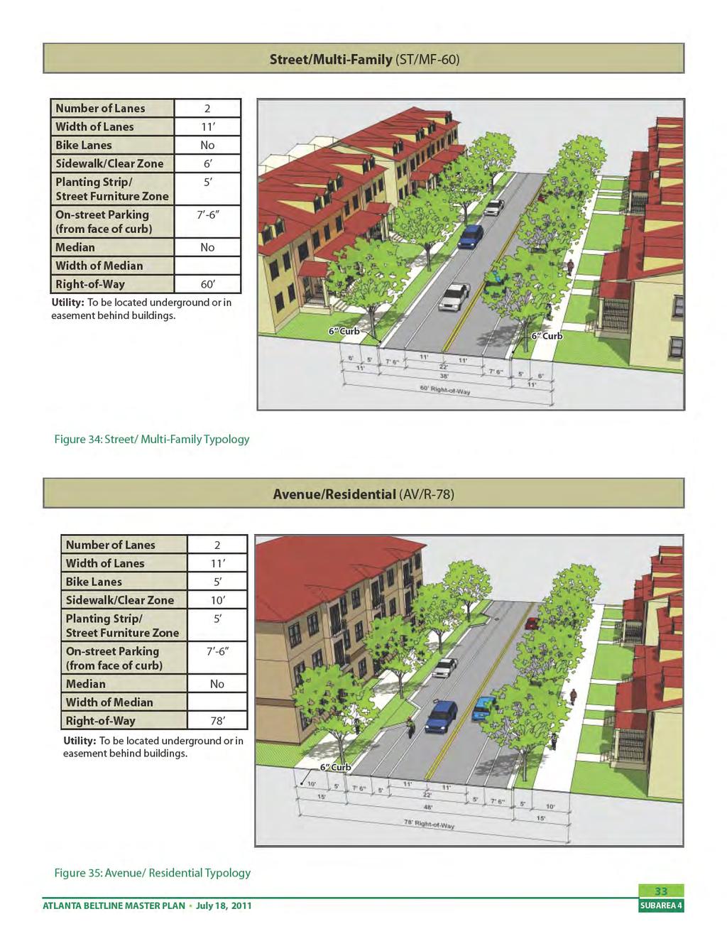
58 o New streets within the redevelopment of the larger parcels along Memorial Drive. Two new north-south streets between Pearl St and Chester Avenue, north of Memorial Drive. One of these new streets also extends south of Memorial Drive, connecting to Old Flat Shoals Road. (NS-3 & NS-4) New east-west street between Pearl St and Chester Avenue, north of Memorial Drive. (NS-5) New east-west street between Chester Avenue and Gibson Street, south of Memorial Drive. (NS-6) Extension of Holtzclaw Street south across Memorial Drive. (NS-7) New east-west street between Bill Kennedy Way and Gibson Street, south of Memorial Drive. (NS-8) o Extension of Woodward Avenue to the east, connecting to new streets. (NS-9) o Chester Avenue extension, south of I-20 which parallels the BeltLine trail. (NS-10) o New streets within the redevelopment of the LaFarge parcel and Atlanta Stockade area along Glenwood Avenue. Extension of Kalb St, which currently ends in the Arts Exchange parking area, to curve southeast, around the existing forested areas, providing a connection to Glenwood Avenue. (NS-11) Two new east-west streets connecting to the Chester Avenue extension and Bill Kennedy Way. (NS-12 & NS-13) o Killian St extension, from Marion Street to Chester Avenue (NS-14) Repurposing Memorial Drive (Memorial Road diet) (OC-1) Additional bicycle and pedestrian connections (PB-3 & PB-4) o Identification of Core and Secondary bicycle routes o Woodward Avenue Bicycle Boulevard o New pedestrian exit from the Inman Park/ Reynoldstown MARTA skywalk to Seaboard Avenue c. Street Framework Plan To address the need for an interconnected street network, the existing street framework for the subarea was evaluated and analyzed throughout the planning process. New streets and extensions of some existing streets are proposed to enhance mobility, walkablility, provide internal circulation and reduce block size as larger parcels redevelop. Atlanta Beltline, Inc. with the City of Atlanta, Department of Planning, have created a BeltLine Street Framework Plan including new street typologies to be applied to proposed streets within subareas during the planning and development process. The new street typologies are a way to ensure that the principles of Complete Streets (providing multi-modal opportunities for all users (of all ages and abilities) whether pedestrians, bicyclists, transit users, or motorists within the rig ht-of-way) are applied to all new streets proposed during the master planning process. The following new street typologies are recommended for Subarea 4: Street/ Multi- Family and Avenue/Residential. An additional street section is provided for the Chester Avenue extension, south of Memorial Drive, due to the BeltLine Trail alignment, which is parallel to this proposed street (see page 45). The BeltLine Street Framework Plan, part of the BeltLine Overlay District, will be updated to include the new streets in Subarea 4. The Street Framework Plan includes public and privately funded streets. In this study area street NS-1 and NS-2 area publicly funded and, streets NS-3 to NS- 14 are privately funded. 32 MOBILITY
59
60
61
62 36 MOBILITY
63 d. Operational & Capacity Improvements Several existing operational and capacity issues were identified and discussed with the community and planning committee during the planning process. Stakeholder suggestions, many of which had been developed in previous plans and studies, including the Connect Atlanta transportation plan and the various Livable Centers Initiative (LCI) studies undertaken in the area, were incorporated into the transportation analysis. The transportation analysis (which includes trip generation, operational analysis, intersection modeling, in addition to many other transportation related analyses) was completed to ensure that mobility recommendations are feasible, valid and support future land uses and build out scenarios. The complete Transportation Analysis report is located in Appendix C. The planning team performed analysis on several different scenarios for capital projects and traffic projections in order to refine and provide support for its final recommendations. This analysis yielded the following findings, establishing a foundation for the more detailed recommendations. Traffic in Subarea 4 does not and will likely not exhaust the capacity of the subarea s roadway infrastructure. Mobility problems in the Subarea are intersection-specific and not constant throughout an entire corridor s length. This is particularly the case with regard to Memorial Drive and the Memorial/Boulevard intersection. Here, many of the problems related to traffic movement are due to heavy northbound through and left turn movements from Boulevard, themselves due in part to the connection to Grant Park and the interchange with Interstate 20. This intersection is a known problem to area mobility because of the heavy demands for signal time that this movement generates and the constraints on adding new vehicle-carrying capacity. However, the heavy ATLANTA BELTLINE MASTER PLAN July 18, 2011 northbound movements occur regardless of changes to land use and traffic within Subarea 4; new development within Subarea 4 that adds eastbound and westbound traffic to Memorial Drive will not worsen this movement. The limitations to street network, such as the barrier formed by Interstate 20 and the superblock formed by the Oakland Cemetery, require both Subarea-originating and regional traffic to pass through a small number of points, which consequently are the most congested intersections. New development scenarios will lead to longer travel times through the Memorial and Bill Kennedy corridors, but not primarily because of the volumes of traffic they add. The main reason for longer travel times is the increase in signalized intersections, although these are likely to be warranted as necessary because of new development. The following are the traffic and transportationrelated recommendations for Subarea 4 : Memorial Road Diet Memorial Drive is recommended to be changed from a four-lane and five-lane undivided roadway to a three-lane roadway from Hill Street to Pearl Street. In the short term, this would leave Memorial s existing curbs intact and simply restripe the roadway surface to accommodate the desired lane configurations, adding on-street parking where dimensions allow and where this space is not needed for other auxiliary lanes. In the long term, street reconstruction should relocate curbs to more closely fit a threelane profile. This may require the removal of parking that is added in the short term, but this is recommended to increase sidewalk width, especially along the north side of Memorial adjacent to the Oakland Cemetery. (OC-1) Corridor-specific street improvements, including the major design details for Memorial Drive are presented more extensively on pg 64 of this section. 37
64 Removal of Memorial Reversible Lane Between Pearl Street and Flat Shoals Avenue, Memorial Drive is recommended to be a three-lane section with two travel lanes and a two-way left turn lane. This would replace its current configuration with the middle reversible travel lane. When designed in conjunction with the road diet, the two-way left turn lane of Memorial Drive east of Pearl Street should be aligned with the current reversible lane of Memorial Drive. Into the future, the entire Memorial Drive three-lane cross section as proposed through the road diet and the reversible lane can allow medians in place of the proposed two-way left turn lane where appropriate. In the short term, it is likely that a two-way left turn will be needed for access to parcels on Memorial that are currently served by driveways. However, as redevelopment continues along the corridor and mid-block driveway cuts are replaced with alternative forms of access (such as alleys and driveways from cross-streets), the two-way left turn lane can be converted to raised medians as appropriate. Detailed study of intersection turning movements should be undertaken at the time that medians are being placed to determine what left turn lane lengths need to be preserved for left turning storage at intersections. In general, it is not recommended that any streets be closed from left turn access from Memorial Drive by extending a median through the intersection. This would compromise the effectiveness of new street network in being able to evenly accommodate traffic growth in the subarea and in reducing the need for mid-block driveways directly on Memorial Drive. (OC-1) Memorial/Boulevard intersection improvements At the intersection of Memorial Drive and Boulevard, a westbound right turn lane is recommended only in conjunction with the road diet along Memorial Drive to maintain traffic flow and to reduce delay at the intersection in the morning peak period. However, the core capacity problem with this intersection is related to northbound movements, specifically in the AM peak period. Both the northbound left turn and through movement experience lengthy queues and delay. Although additional northbound through-movement capacity would also help to alleviate congestion and delay at this intersection, such an approach is not recommended due to its impact on surrounding property and the difficulty of merging two lanes of northbound traffic back into a single lane north of the Boulevard/ Memorial Drive intersection. The short distance between this intersection and the Boulevard curve at Carroll Street suggest that such merging would need to happen immediately. This would likely result in slow and awkward traffic operations, potentially negating the benefit of the added capacity. (I- 1) Memorial/Bill Kennedy intersection improvements Although capacity at this intersection will remain adequate for future development, its current operational challenges due to insufficient lateral width for truck and heavy vehicle turning movements could be alleviated by modifying the southeast corner curb radius and by relocating the stop bar of the middle lane. This allows trucks to make their movement without a possible stop and time spent waiting on westbound queued vehicles to reverse and allow sufficient clearance space. 38 MOBILITY


65 Although the current turn radius at the southeast corner is designed to accommodate trucks to make this movement, detailed design of this recommended project should evaluate the effectiveness of the current radius to determine whether a larger curb radius is needed. This should be considered in light of the land use recommendations of the plan and the intersection design should consider the critical need for safe and convenient pedestrian access through this intersection, especially given the BeltLine corridor s use of Bill Kennedy Way and the Subarea 4 Master Plan s recommendation for a transit station immediately north of the Memorial Drive /Bill Kennedy Way intersection. (I-2) Refer to Figures 37 and 38 for an illustration of these recommendations. Figure 37 - Current Truck Turning Conflict Potential Howell Drive extension and connection to I-20 ramps/moreland ramps Although this is not a capacity-based recommendation, the extension of Howell Drive south and east to intersect with Moreland Avenue opposite the westbound I-20 off-ramp would create operational benefits for a larger area. One of the principal operational benefits of this project is the ability for vehicles exiting from westbound Interstate 20 to cross Moreland Avenue (as opposed to turning right there) and to use the Howell extension to turn left on Memorial and proceed west. Currently, vehicles must turn right at the end of the ramp and then left immediately, forcing vehicles to merge across moving traffic lanes and potentially slowing traffic operations (or causing vehicle conflict). This project was originally a recommendation of the Connect Atlanta transportation plan, which envisioned Flat Shoals Avenue as the street to be connected due to its existing signal with Moreland Avenue. However, upon closer analysis of property development potential that was performed for Subarea 4, the use of Howell Drive would allow for more flexibility in redevelopment of these properties and more optimal spacing between signals. (I-3) Coordination with GDOT will be required to ensure the alignment of the ramps and the Howell Drive extension. In addition, the signal controlling the westbound off-ramp at Moreland would need to be reconfigured to allow for westbound movements. Specific phasing and signal equipment to be used, especially in accommodating turning movements, should be determined with a more detailed traffic study based on conditions at the time of the project s advancement. Figure 38 - Relocation of Westbound Stop Bar ATLANTA BELTLINE MASTER PLAN July 18,

66 Arkwright/Moreland right in/right out configuration In addition to the Howell Drive extension, the removal of the Arkwright/Moreland signal would eliminate a problem of insufficient spacing between this signal and the Moreland/ Memorial signal. Currently, turning traffic from Memorial may be trapped at this signal and can quickly exhaust the storage capacity of the short block. To facilitate pedestrian crossings at this intersection, the signal should be replaced with a rectangular rapid flash beacon (RRFB), a pedestrian-activated traffic control device that alerts motorists to a pedestrian crossing with flashing lights and signage. (I-4) Figure 39 - Extension of Howell Drive and Arkwright-Memorial Intersection 40 MOBILITY


67 e. Pedestrian & Bicycle Improvements The following are recommendations specific to bicycle and pedestrian safety and circulation. Although they may be related to other recommendations and tied into the operation of other modes of travel, their primary intent is to serve bicyclists and pedestrians. Woodward Avenue Bicycle Corridor Throughout the Subarea 4 planning process, community members expressed an interest in east-west bicycle facilities, but emphasized their concerns and discomfort with use of Memorial as a primary bicycle corridor. The recommendation of the Subarea 4 plan is to use Woodward Avenue as a bicycle route, configured as a bicycle boulevard emphasizing free movement of bicycles and calmed vehicle traffic. Woodward is recommended largely because of its parallel and proximate location relative to Memorial Drive and because of its relative lack of dimensional constraints. A street of ample width and paving such as Woodward Avenue Figure 40 - Existing Woodward Avenue Diagram allows both bicycles and vehicles to share the road without compromising safety or vehicular level of service. Several design criteria should be met before designating a bicycle boulevard, particularly because once it is an established route, bicyclists will expect the roadway to be safe and efficient. Bicycle boulevards are intended to provide direct through-travel in high-demand bicycle corridors, and can be effective in connecting other types of facilities (bicycle lanes, shared-use paths, etc.). The surface of the roadway where bicycles would generally travel should be smooth and the route should be maintained to keep roadway debris out of the bicycle travel areas. As one of the key principles of bicycle boulevards is priority to bicycle traffic at intersections it is recommended that stop-sign control on local streets be modified as needed to favor Woodward. (PB-1) Figure 43 details recommendations for phasing of the boulevard to follow likely addition of street network. Also recommended is the placement of a pedestrian hybrid beacon at the Woodward/ Boulevard and Woodward/Cherokee intersections. This signal is activated by the pedestrian or cyclist by hand (in the case of one of the beacon s early demonstration projects, the activation button is located within easy reach of a mounted cyclist in the roadway). It does not give full movement access to vehicles on the cross-street: these remain controlled by a stop sign. It is intended to control cross-street traffic long enough to ensure a safe crossing of Boulevard for cyclists or pedestrians. Figure 41 - Proposed Woodward Avenue Diagram ATLANTA BELTLINE MASTER PLAN July 18, 2011 Its basic use is described as follows: 1. A pedestrian or cyclist approaches the intersection and pushes the button to activate the signal. 2. Signals controlling the main roadway flash a yellow beacon, then proceed on a solid yellow-red sequence to stop motorists, just 41

68 as a typical signal would. 3. The bicycles and pedestrians cross, guided by either a bicycle-based signal, a standard pedestrian signal, or both, while vehicle traffic on the same street remains controlled by a stop sign. Vehicle traffic can take advantage of the cross street being controlled by the HAWK s red light, but it must stop first and give priority to bicycles and pedestrians. 4. Bicycles and pedestrians are given warning that their phase ends and then controlled with a red beacon (or a do not walk pedestrian signal beacon). 5. The main roadway s red beacon turns off and drivers proceed. Boulevard/Glenwood Avenue Pedestrian Improvements At the intersection of Boulevard and Glenwood Avenue, immediately south of the I-20 off-ramps, there is currently no designated pedestrian crosswalk. While there is a crosswalk at the intersection of the eastbound off-ramp with Boulevard, this is located approximately 120 feet from the Glenwood/ Boulevard intersection and is in a far larger cross-section of Boulevard intended to promote vehicle mobility and storage capacity for turning onto I-20 ramps. Although it is not common practice to designate a mid-block crossing within such close proximity to an existing signalprotected crosswalk, the Subarea 4 Master Plan recognizes neighborhood pedestrian need and recommends that an additional crosswalk be signed and striped slightly south of the south side of Glenwood Avenue, allowing a more direct crossing of Boulevard for residents of Glenwood Avenue. It is important that this crossing be enhanced with pavement markings, signage and, ideally, flashing lights or beacons activated by a push-button device that allow motorists to see that pedestrians wish to cross. This recommendation may be taken in conjunction with reducing the turning radii for the eastbound right turns from the I-20 offramp to slow traffic transitionally from the ramp to Boulevard, which is a City of Atlanta street (PB-2) Core and Secondary Bicycle Routes Providing a safe, efficient and continuous network of pedestrian and bicycle facilities was identified as one of the Subarea 4 Master Plan goals for circulation and mobility. Improving mobility for the non-motorist to and from the BeltLine corridor and community amenities will be met through the plan s recommendation of a hierarchy of core and secondary bicycle routes, sidewalk, streetscape, and multi-use trail projects. Many of the core and secondary routes identified in this master plan were first identified in the bicycle master plan of the Connect Atlanta comprehensive transportation plan. Additional opportunities were explored and advanced in the Subarea 4 Master Plan to support and enhance the core and secondary network established in the Connect Atlanta bicycle master plan. See figure 56 for designated core and secondary routes. (BP-3 & BP-4) Figure 42 - Woodward Boulevard Bicycle Boulevard Phases 42 MOBILITY
69 f. Transit Improvements Subarea 4 Master Plan considered five principal street corridors for design recommendations, noting the unique needs and roles of each in serving new development and transportation infrastructure. The recommendations for street design are detailed for each of these five corridors here. Grant Street Grant Street is a relatively narrow cartway and is likely to change in character only if the BeltLine transit alignment using Memorial Drive and Grant Street is chosen. The cross-section (figures 44 & 45) details what would be needed for appropriate transit accommodation and suitable pedestrian space given the street s potential transit needs. If Atlanta BeltLine transit uses Grant Street, a transit traffic queue bypass should be considered by way of widening Grant Street to the east. (T-1) Memorial Drive Considerable attention has been given to the operational logistics of the Memorial Drive road diet. The cross-sections (figures 46-50) detail its overall design, illustrating one location in the current reversible-lane section (between Bill Kennedy Way and Chester Avenue, adjacent to the present A&P Lofts building) and another in the current four-lane section (adjacent to Oakland Cemetery near Cherokee Avenue). (T-2) Chester Avenue South of Interstate 20, Chester Avenue has been proposed for extension in the Subarea 4 Land Use Plan to accommodate currentlyunderway and potential future development at the 880 Glenwood Avenue and Lafarge properties, respectively. It is also the preferred location of this section of the BeltLine Trail alignment, with the trail being located on the west side of the cartway. With these factors in mind, Chester Avenue is an exemplary residential street with a trail envelope serving a higher-intensity land use context, although it is intended to be a local street in function. Figure 51 details key design dimensions, especially travel lane widths and separation of the multi-use trail from the cartway. (T-3) Bill Kennedy Way Bill Kennedy Way will likely carry both BeltLine transit and trail, unless a new, parallel bridge for the trail is constructed. The cross-section (figures 52 & 53) illustrates the location of the multi-use trail on the west side of the street, with signposted crossings of the I-20 access ramps. (T-4) Wylie Street Wylie Street will carry the BeltLine multi-use trail and is one of the three alternatives to carry transit between the Reynoldstown and Decatur Belt sections of BeltLine right-of-way. As such, it will need reconfiguration to provide adequate width for the multi-use trail between the north curb of Wylie Street and the Hulsey Yard retaining wall, two 12-foot travel lanes that can accommodate light rail transit vehicles, and adequate sidewalk width to allow streetscaping and, if need be, a platform for a transit stop (figures 54 & 55). (T-5) In addition specific corridors related to future transit, the Subarea 4 Master Plan recommends improved access to existing MARTA transit. The BeltLine transit and trail will greatly expand access to the MARTA rail system. Subarea 4 Master Plan recommends reconnecting Walthall Street to Seaboard Avenue (as it existed historically) south of the Inman Park/Reynoldstown MARTA Station and creating a new pedestrian exit from the MARTA skywalk to Seaboard Avenue to shorten the walking distance to the Edgewood Retail District shopping center. ATLANTA BELTLINE MASTER PLAN July 18,


70 Grant Street s Figure 43: Grant Street Alternative A Existing lane geometries dictate 12-foot lanes in both the north and south directions, with no median or other separation between the directions. This allows for eight foot sidewalks on both sides of the street. Figure 44: Grant Street Alternative B Lanes are again 12 feet wide, but this alternative indicates shared right-of-way by incorporating fixed guideway transit into existing vehicle lanes. s remain eight feet wide. This alternative depends on the BeltLine transit alignment using Grant Street. Memorial Drive at Chester Figure 45: Memorial Drive at Chester Alternative A This section of Memorial is currently operated as a reversible lane. Alternative A shows Memorial Drive as a fixed three-lane section, with one lane in each direction and a shared left-turn lane. This provides for sidewalks on both sides of the street with a planted separation from vehicular traffic. The sidewalk profile illustrates how a public-sector streetscape project could fit in existing rightof-way with minimum acquisition needs. As development occurs, private parties will abide by the sidewalk standards in their zoning district Figure 46: Memorial Drive at Chester Alternative B Here, Memorial Drive is illustrated as a BeltLine transit corridor, where transit shares right-of-way with vehicular traffic. The center lane is maintained as a two-way left turn lane, and sidewalks remain unchanged. This alternative depends on the BeltLine transit alignment using Memorial Drive. 44 MOBILITY


71 Memorial Drive at Oakland Cemetery Figure 47: Existing Memorial Drive at Oakland Cemetery (Looking West) Currently, Memorial Drive consists of two lanes in each direction, varying in width from 10 to 11 feet, with narrow sidewalks abutting Oakland Cemetery and storefront parking. Figure 48: Proposed Memorial Drive Alternative A (No Transit) Directional lanes are reduced to one in favor of adding a shared left-turn lane and providing additional space for pedestrians. Pedestrian safety and comfort is greatly improved with the addition of wider sidewalks and the use of plantings to separate pedestrians from vehicular traffic. Chester Avenue (adjacent to LaFarge Property) Figure 49: Proposed Memorial Drive Alternative B (Transit) Directional lanes are reduced to one in favor of adding a shared left-turn lane and providing additional space for pedestrians. Pedestrian safety and comfort is greatly improved with the addition of wider sidewalks and the use of plantings to separate pedestrians from vehicular traffic. Transit service shares the directional lane with vehicular traffic, with some sidewalk space being used as neighborhood transit stops. The sidewalk profile illustrates how a publicsector streetscape project could fit in existing right-of-way with minimum acquisition needs. As development occurs on the south side of Memorial Drive, private parties will abide by the sidewalk standards in their zoning district. ATLANTA BELTLINE MASTER PLAN July 18, 2011 Figure 50: Chester Avenue Adjacent to LaFarge (Looking North) Chester is recommended as a two-lane street with onstreet parking on at least one side. The BeltLine trail alignment is on the west side of the street. 45


72 Bill Kennedy Way s Figure 51: Bill Kennedy Way BetLine Transit will likely use the existing Bill Kennedy Way crossing over I-20, as this image illustrates. Transit vehicles share the existing lanes dedicated to personal automobile traffic. The BeltLine trail remains on the western side of the roadway with an additional sidewalk to the east. Wylie Street s Figure 52: Wylie Street Alternative A The BeltLine Trail runs adjacent to Wylie Street, as this cross-section displays. Lanes are demarcated as 12 feet in width, providing space for the trail on one side and an enhanced neighborhood sidewalk with a six-foot separation from the street along the other side. Figure 53: Wylie Street Alternative B Alternative B illustrates the addition of transit service along Wylie Street. In this case, transit service shares right-of-way with existing vehicle lanes. This alternative maintains the BeltLine trail and enhanced sidewalks seen in Alternative A. 46 MOBILITY
73 Development Quantification The BeltLine Subarea 4 land use plan increases overall housing and employment density in the areas of its transit stations. Table 02 below details the residential dwelling units and employment (measured in jobs) for each of five BeltLine transit station areas: Glenwood Avenue at Bill Kennedy Way, the railroad depot at Memorial Drive and Bill Kennedy Way, Pearl Street at Memorial Drive, Wylie Street at Flat Shoals Avenue, and at the end of Seaboard Street (the likely transfer point to the Inman Park/Reynoldstown MARTA station). These represent the stations in all three of the BeltLine transit alignment alternatives that lie within the Subarea 4 TAD parcels and, consequently, the Subarea 4 redevelopment area. To perform this analysis, the study team considered population and employment data from the ARC travel demand model traffic analysis zones (TAZ), which provide estimates for population, households and employment detailed by a range of industrial sectors. Each half-mile station area was applied to the TAZ boundaries with the percentage of each TAZ that lay within a given station area being applied to that TAZ s housing and employment figures. The sum total of housing units and employment for each TAZ portion were considered to be the current numbers for The study team then applied each station area boundary to the Subarea 4 redevelopment plan, calculating those portions of the redevelopment plan/tad area in each half-mile station area and applying standard multipliers for housing and employment density by land use type. These resulting housing and employment density figures were added to the TAZ-derived 2010 figures to arrive at a total station area housing and employment figure for the BeltLine Subarea 4 land use plan s hypothetical build-out. In addition to these calculations being performed for each specific station area, they were also performed for the agglomerated area of all five station areas, allowing the analysis to control for geographic overlap between the station areas and what would be the resulting double-counting of households and employment. In general, the intent of this analysis is not to identify or forecast a precise number of dwelling units or jobs in each of the transit station areas, but rather to present an order-of-magnitude difference between current land uses and densities and those that could be allowed under the Subarea 4 land use plan. TRANSIT STATION POPULATION AND EMPLOYMENT ESTIMATES Residential Dwelling Estimated Dwelling Stop Location Employment (Jobs) Units Units Per Acre Estimated Jobs Per Acre Glenwood Avenue Buildout Memorial-Depot Buildout Wylie/Flat Shoals Buildout Seaboard Street Buildout Pearl Street Buildout TOTAL, Not Including Overlap Buildout Table 02 - Development Quantification ATLANTA BELTLINE MASTER PLAN July 18,
74 g. Project Implementation: Mobility Recommendations Summary Project ID: Project Name: Project Type: Mobility Recommendations Summary: Streets Project Length (approx. linear feet): Project Description: I-1 Memorial/Boulevard intersection improvements Intersection Improvement NA At the intersection of Memorial Drive and Boulevard, a westbound right turn lane is recommended only in conjunction with the road diet along Memorial Drive to maintain traffic flow and to reduce delay at the intersection in the morning peak period. I-2 Memorial/Bill Kennedy intersection improvements Intersection Improvement NA Modify the southeast corner curb radius and by relocating the stop bar of the middle lane to alleviate insufficient lateral width for truck and heavy vehicle turning movements. I-3 Howell Drive extension and connection to I-20/Moreland ramps Intersection Improvement NA The extension of Howell Drive south and east to intersect with Moreland Avenue and I-20 on/off-ramps. I-4 Arkwright/Moreland signal closure and right in/right out configuration Intersection Improvement NA Removal of the Arkwright Place/Moreland Avenue signal. Provide right-in/ right-out access only NS-1 Reconnection of Walthall Street Street extension 45 lf Reconnection of Walthall Street to Seaboard Avenue, south of the Inman Park/Reynoldstown MARTA Station NS-2 Howell Drive extension and connection to I-20/Moreland Avenue interstate ramps. street modification/ realignment & new street 333 lf Realignment/modification of the Flat Shoals Avenue, Howell Drive and Arkwright Place intersection. Howell Drive extension and connection to I- 20/Moreland Avenue interstate ramps. NS-3 NS-4 NS-5 New north-south street between Pearl St and Chester Avenue New north-south street between Pearl St and Chester Avenue New east-west street between Pearl St and Chester Avenue New Street New Street New Street 347 lf 925 lf 934 lf New north-south street between Pearl St and Chester Avenue, north of Memorial Drive New north-south street between Pearl St and Chester Avenue, north and south of Memorial Drive. New east-west street between Pearl St and Chester Avenue creating smaller blocks NS-6 New east-west street between Chester Avenue and Gibson Street New Street 1,092 lf New east-west street between Chester Avenue and Gibson Street, connecting over Bill Kennedy Way NS-7 Holtzclaw Street extension Street extension 894 lf Extension of Holtzclaw Street south across Memorial Drive. NS-8 New east-west street between Bill Kennedy Way and Gibson Street New Street 788 lf New east-west street between Bill Kennedy Way and Gibson Street, paralleling I-20 NS-9 Woodward Ave. extension Street extension 785 lf Extension of Woodward Avenue to the east, connecting to new streets NS-10 Chester Ave. extension Street extension 855 lf Chester Avenue extension, south of I-20 which parallels the BeltLine trail. NS-11 Kalb St. extension Street extension 1,743 lf Extension of Kalb St, which currently ends in the Arts Exchange parking area, to curve southeast, around the existing forested areas, providing a connection to Glenwood Avenue NS-12 new east-west street within LaFarge property New Street 497 lf New east-west street within LaFarge property, connection Kalb St extension and Chester Avenue extension NS-13 new east-west street within LaFarge property New Street 921 lf New east-west street within LaFarge property, connection Kalb St extension and Chester Avenue extension and Bill Kennedy Way NS-14 Killian St extension Street extension 505 lf Killian St extension, from Marion Street to Chester Avenue 48 MOBILITY
75 Project ID: Project Name: Project Type: OC-1 PB-1 Memorial Road Diet and Removal of Memorial Reversible Lane Woodward Avenue Bicycle Corridor Operational/ Capacity Pedestrian & Bicycle Project Length (approx. linear feet): Phase I = 4030 lf Phase II = 5200 lf (select one of the two options for Phase II) Phase I = 5,328 lf Phase II = 2,400 lf Phase III = 2,250 lf Phase IV = 2,480 lf Project Description: Phase I: Memorial Drive is recommended to be a three-lane section with two travel lanes and a two-way left turn lane from Moreland Avenue to Pearl Street. This would replace its current configuration featuring the middle reversible travel lane. Phase II, Option A: Road diet involving estriping, basic sidewalk improvements and street trees. No curb relocation. Phase II, Option B: Move all curbs, widen sidewalks, plant street trees and Use Woodward Avenue as a bicycle route, configured as a bicycle boulevard emphasizing free movement of bicycles and calmed vehicle traffic. Phase 4 refers to western extension from Hill St west to Georgia Archives building (the extent of BeltLine Subarea 4). PB-2 Boulevard/Glenwood Avenue Pedestrian Improvements Pedestrian & Bicycle NA An additional crosswalk be signed and striped slightly south of the south side of Glenwood Avenue, allowing a more direct crossing of Boulevard for residents of Glenwood Avenue. PB-3 Core Bike Routes Pedestrian & Bicycle 29,425 lf PB-4 Secondary Bike Routes Pedestrian & Bicycle 20,050 lf Identified throughout Subarea 4, core bike routes provide a designated bike line on road for cyclists Identified throughout Subarea 4, secondary bike routes are noted with signage, although typically do not have a designated bike lane. T-1 Grant Street Transit Improvements 1,216 lf Recommendations for appropriate BeltLine Transit accomodation and suitable pedestrian space T-2 Memorial Drive Transit Improvements 5,610 lf Recommendations for appropriate BeltLine Transit accomodation and suitable pedestrian space T-3 Chester Avenue Transit Improvements 855 lf Recommendations for appropriate BeltLine Trail accomodation and suitable pedestrian space T-4 Bill Kennedy Way Transit Improvements 2,486 lf Recommendations for appropriate BeltLine Transit and Trail accomodation and suitable pedestrian space T-5 Wylie Street Transit Improvements 1,940 lf Recommendations for appropriate BeltLine Transit and Trail accomodation and suitable pedestrian space Table 03 - Project ImplementationTable: Mobility Recommendations Summary for Streets ATLANTA BELTLINE MASTER PLAN July 18,
76
77
78
79 Project ID: Street Name: Project Type: S-1 Arkwright Place S-2 Boulevard Drive S-3 Chester Avenue S-4 Estoria Street S-5 Faith Avenue S-6 Field Street S-7 Flat Shoals Avenue S-8 Florida Avenue S-9 Fulton Terrace S-10 Gaskill Street S-11 Gift Avenue S-12 Glenwood Place S-13 Hardee Street S-14 Hemlock Circle S-15 Holtzclaw Street S-16 Howell Drive S-17 Kenyon Street S-18 Kirkwood Avenue S-19 Marcus Street S-20 McDonald Street S-21 Northern Avenue Street S-22 Old Flat Shoals Rd S-23 Pearl Street S-24 Robson Street S-25 Sanders Avenue S-26 Seaboard Avenue S-27 Selman Street S-28 Sherwood Street S-29 Stovall Street S-30 Tye Street S-31 Wade Street S-32 Wilbur Avenue Mobility Recommendations Summary: s Project Length: ( approx. linear feet) Project Description: Roads Intersecting the TAD with no 971 lf Recommendation for sidewalk on both sides of the street 130 lf Recommendation for on both sides of the street 601 lf Recommendation for on both sides of the street 363 lf Recommendation for on both sides of the street 1,145 lf Recommendation for on both sides of the street 112 lf Recommendation for on both sides of the street 604 lf Recommendation for on both sides of the street 173 lf Recommendation for on both sides of the street 1,157 lf Recommendation for on both sides of the street 59 lf Recommendation for on both sides of the street 708 lf Recommendation for on both sides of the street 353 lf Recommendation for on both sides of the street 604 lf Recommendation for on both sides of the street 368 lf Recommendation for on both sides of the street 367 lf Recommendation for on both sides of the street 1,342 lf Recommendation for on both sides of the street 413 lf Recommendation for on both sides of the street 286 lf Recommendation for on both sides of the street 286 lf Recommendation for on both sides of the street 161 lf Recommendation for on both sides of the street 737 lf Recommendation for on both sides of the street 1,316 lf Recommendation for on both sides of the street 1,190 lf Recommendation for on both sides of the street 251 lf Recommendation for on both sides of the street 1,489 lf Recommendation for on both sides of the street 445 lf Recommendation for on both sides of the street 545 lf Recommendation for on both sides of the street 742 lf Recommendation for on both sides of the street 1,227 lf Recommendation for on both sides of the street 565 lf Recommendation for on both sides of the street 197 lf Recommendation for on both sides of the street 649 lf Recommendation for sidewalk on both sides of the street ATLANTA BELTLINE MASTER PLAN July 18,
80 Project ID: Street Name: Project Type: S-33 Arkwright Place S-34 Berean Aveune S-35 Berne Street S-36 Brantley Street S-37 Cameron Street S-38 Chastain Street S-39 Chester Avenue S-40 Colmer Avenue S-41 Cummings Street S-42 Estoria Street S-43 Faith Avenue S-44 Field Street S-45 Flat Shoals Avenue S-46 Fulton Terrace S-47 Gaskill Street S-48 Gibson Street S-49 Hansell Street SE S-50 Howell Drive S-51 Kenyon Street S-52 Kirkwood Avenue S-53 Marcus Street S-54 Marion Street S-55 McDonald Street S-56 Merlin Avenue S-57 Pearl Street S-58 Sanders Avenue S-59 Seaboard Avenue S-60 Selman Street S-61 Short Street S-62 Stovall Street S-63 Tye Street S-64 Wylie Street Project Length: ( approx. linear feet) Roads Intersecting TAD with on One Side 174 lf 238 lf 437 lf 398 lf 236 lf 1,002 lf 637 lf 328 lf 745 lf 204 lf 470 lf 408 lf 2,126 lf 875 lf 690 lf 674 lf 381 lf 127 lf 305 lf 1,039 lf 633 lf 396 lf 732 lf 329 lf 453 lf 181 lf 1,272 lf 304 lf 597 lf 208 lf 234 lf 316 lf Project Description: Recommendation for addition of sidewalk on side of street where sidewalk does not currently exist Recommendation for addition of sidewalk on side of street where sidewalk does not currently exist Recommendation for addition of sidewalk on side of street where sidewalk does not currently exist Recommendation for addition of sidewalk on side of street where sidewalk does not currently exist Recommendation for addition of sidewalk on side of street where sidewalk does not currently exist Recommendation for addition of sidewalk on side of street where sidewalk does not currently exist Recommendation for addition of sidewalk on side of street where sidewalk does not currently exist Recommendation for addition of sidewalk on side of street where sidewalk does not currently exist Recommendation for addition of sidewalk on side of street where sidewalk does not currently exist Recommendation for addition of sidewalk on side of street where sidewalk does not currently exist Recommendation for addition of sidewalk on side of street where sidewalk does not currently exist Recommendation for addition of sidewalk on side of street where sidewalk does not currently exist Recommendation for addition of sidewalk on side of street where sidewalk does not currently exist Recommendation for addition of sidewalk on side of street where sidewalk does not currently exist Recommendation for addition of sidewalk on side of street where sidewalk does not currently exist Recommendation for addition of sidewalk on side of street where sidewalk does not currently exist Recommendation for addition of sidewalk on side of street where sidewalk does not currently exist Recommendation for addition of sidewalk on side of street where sidewalk does not currently exist Recommendation for addition of sidewalk on side of street where sidewalk does not currently exist Recommendation for addition of sidewalk on side of street where sidewalk does not currently exist Recommendation for addition of sidewalk on side of street where sidewalk does not currently exist Recommendation for addition of sidewalk on side of street where sidewalk does not currently exist Recommendation for addition of sidewalk on side of street where sidewalk does not currently exist Recommendation for addition of sidewalk on side of street where sidewalk does not currently exist Recommendation for addition of sidewalk on side of street where sidewalk does not currently exist Recommendation for addition of sidewalk on side of street where sidewalk does not currently exist Recommendation for addition of sidewalk on side of street where sidewalk does not currently exist Recommendation for addition of sidewalk on side of street where sidewalk does not currently exist Recommendation for addition of sidewalk on side of street where sidewalk does not currently exist Recommendation for addition of sidewalk on side of street where sidewalk does not currently exist Recommendation for addition of sidewalk on side of street where sidewalk does not currently exist Recommendation for addition of sidewalk on side of street where sidewalk does not currently exist Table 04 - Project ImplementationTable: Mobility Recommendations Summary for s 52 MOBILITY
81
82
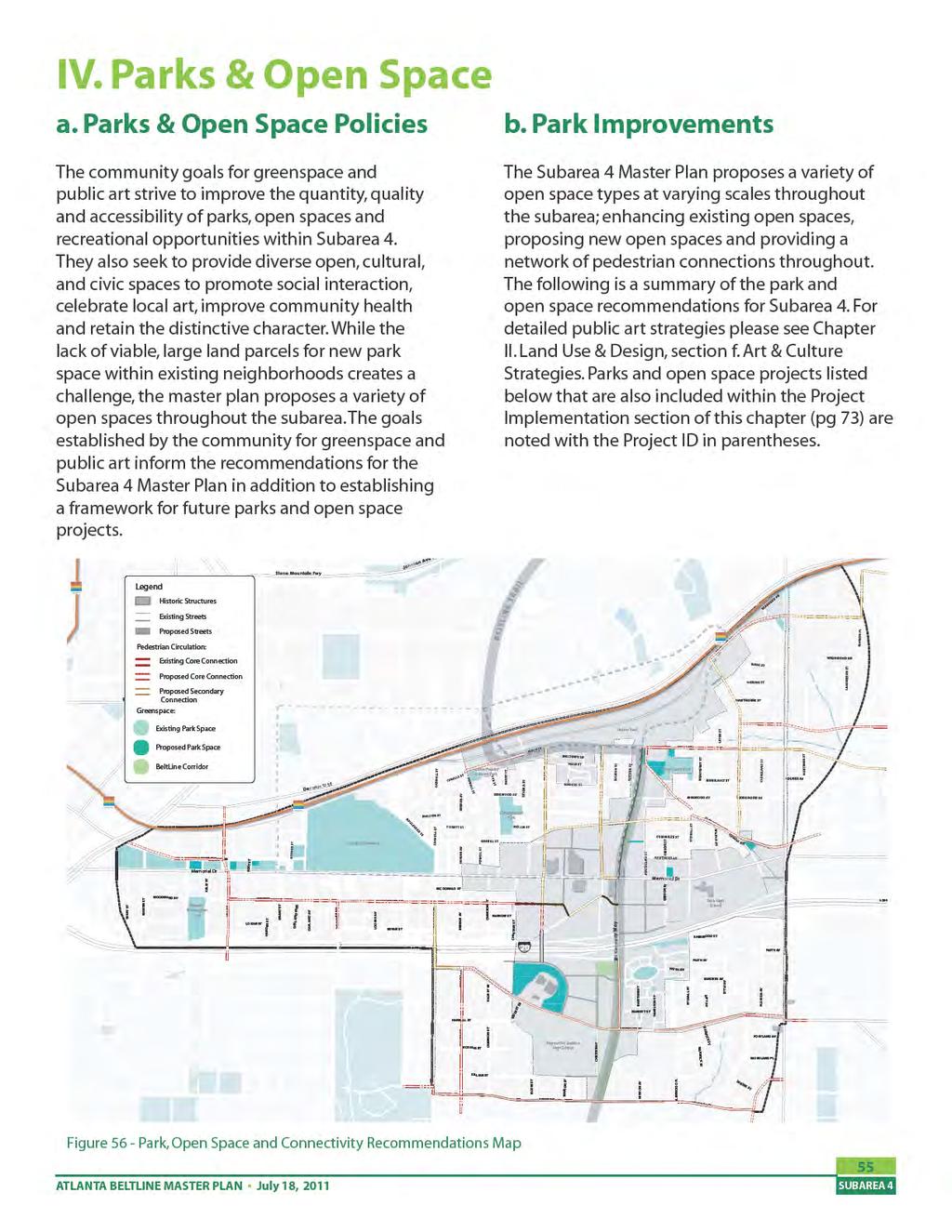
83


84 Proposed expansion of Lang-Carson Park Lang-Carson Park in Reynoldstown is currently surrounded by residential and industrial uses with minimal street frontage. The community commented that the park at times feels unsafe and unwelcoming. The Subarea 4 Master Plan recommends expanding Lang-Carson Park to the west and north, increasing the street frontage along Flat Shoals Avenue and Wylie Street, creating a green connection to the Atlanta BeltLine corridor, and improving safety and accessibility. This expansion will allow for additional open space programming opportunities for the Reynoldstown neighborhood and increase the quantity and quality of open space for the subarea overall. A comprehensive master plan for the park is recommended as an initial step. (P-1) Historic Atlanta Stockade Currently, the structures provide space for community functions and are surrounded by trees and dense vegetation. The Subarea 4 Master Plan proposes that the forest and school yard around the historic Atlanta Stockade be utilized as publicly accessible parkspace, leveraging its uniqueness as a cultural resource while providing open space in a much needed open space within the subarea. This recommendation could occur as a neighborhood initiative, allowing public access although the land would be privately owned. (P-2) Figure 57 - Proposed Park Expansion Proposed park/ community facility at Atlanta Stockade As mentioned earlier, the Atlanta Stockade was built in 1896 and was once the largest city-built penal complex in the state. The site contains the former prison, blacksmith shop and stables; all three are on the National Register of Historic Buildings. The site also includes The Arts Exchange building, which is not on the National Register, but is noted by the AUDC s Historic Resource Survey as a contributing non residential structure. These historic gems, hidden from street view with dense vegetation, are located on one of the highest points in the area, rising 50-feet above the Lafarge site to the east. 56 Expansion of the WonderRoot Community Garden WonderRoot, a non-profit organization committed to uniting artists and community to inspire positive social change, is currently utilizing an adjacent vacant property for a community garden. The master plan suggests that expansion of the community garden to other adjacent vacant properties to increase the garden acreage and offer future programming opportunities is appropriate; although only as an interim use until redevelopment occurs. (P-3) WonderRoot Community Garden PARKS & OPEN SPACE
85 The City of Atlanta Watershed Management property on Holtzclaw Street This parcel is intended to remain a city property and provide a location for water storage in the future. Although this property cannot have full public access, the Subarea 4 Master Plan proposes a public access path along the northern boundary of the property from Hotlzclaw Street to a proposed BeltLine Overlook structure (to also offer an interpretive and public art opportunity), which offers spectacular views of the BeltLine corridor, the neighborhoods to the west and Downtown Atlanta. The Reynoldstown Civic Improvement League and NPU-N have recommended the parcel for a future park space.(p-4) Proposed open space/ neighborhood gateway at the intersection of Flat Shoals Avenue, Howell Drive, Arkwright Place and Walthall Street This intersection of streets is recommended for realignment/ modification within the Subarea 4 Master Plan (please refer to Mobility Section for additional description). A reconfiguration of this area will provide the opportunity to create an open space opportunity which could incorporate a neighborhood gateway. (P-5) Proposed Memorial/MLK (Capitol Gateway) Mall This proposed open space initiative, included within the Imagine Downtown Plan and reviewed during the previous studies portion of this planning process, is a large, expansive green lawn extending east from the State Capitol building bridging over I-75/85 and continuing through the Capitol Gateway development between Memorial Drive and Martin Luther King Jr. Drive to connect to Oakland Cemetery (Imagine Downtown: Encore pg 80). The City of Atlanta has continued to purchase land for this future open space and the Subarea 4 Master Plan reinforces this initiative by connecting within the surrounding areas of the proposed open space via core and secondary bike routes. (P-6) c. Greenway Trail Improvements The proposed BeltLine Trail alignment enters Subarea 4 from the north via the existing Tunnel at Krog Street. Running east along Wylie Street, the trail intersects with the existing railroad rightof way at Wylie Street and Flat Shoals Avenue. At this point the BeltLine trail follows the railroad right-of way south to Memorial Drive and the proposed BeltLine transit stop at the historic train depot- at the intersection of Memorial Drive and Bill Kennedy Way. The trail will be in a greenway condition; utilizing the linear corridor left behind from the former railroad. Along the corridor, opportunities for pocket parks exist and should be maximized when redevelopment occurs to provide additional recreation areas as well as additional access points to the BeltLine. From the Memorial Drive and Bill Kennedy Way intersection, the trail runs along the west side of Bill Kennedy Way, crosses over I-20 and turns west into the existing LaFarge property. The trail then immediately heads south along the proposed Chester Avenue extension. The trail follows along the west side of Chester Ave, south of Glenwood Avenue and Maynard Jackson High School, then follows the existing CSX railroad right-of-way as it travels south into Subarea 3. ATLANTA BELTLINE MASTER PLAN July 18,

86 The BeltLine multi-use trail provides the spine for pedestrian connectivity within the Subarea. Additionally, the Subarea 4 Master Plan recommends numerous sidewalk and bicycle route connections to the BeltLine. The following list provides a summary of highlights within the proposed pedestrian connectivity network. Extension of Lang-Carson Park to provide a greenway connection from the park to the BeltLine Pedestrian path from Holtzclaw Street to BeltLine and proposed BeltLine Overlook. Core and secondary bike networks connecting existing parks within the subarea to the BeltLine, as well as connecting existing multiuse trails and bike lanes outside of the subarea to the BeltLine. Proposed Bicycle Boulevard along Woodward Avenue from Hill Street to Pearl Street. To the east, the boulevard should be connected to the BeltLine trail and Gibson Street. To the west, the boulevard should be extended to downtown and ultimately to the Atlanta University Center. d. Other Open Space Improvements In addition to park, open space and pedestrian connections identified within the Subarea 4 Master Plan, the redevelopment proposed to occur over the next 25 years will provide numerous opportunities to incorporate parks, plazas, open spaces, linear connections and greenways within new development, connecting to and enhancing the network overall. An example of this can be seen within Glenwood Park, a recent mixed use redevelopment in Subarea 4. Glenwood Park incorporates formal plaza spaces, programmed park space, community gardens and community facilities within a walkable, pedestrian friendly neighborhood. Open space and public use opportunities also exist along the BeltLine right-of-way from Wylie Street to Memorial Drive. Potential for pocket parks and additional access points to the BeltLine should be maximized when redevelopment occurs within the right-of-way as well as adjacent vacant lands. Glenwood Park Plaza 58 PARKS & OPEN SPACE
87 e. Project Implementation: Parks & Open Space Recommendations Summary Parks & Open Space Recommendations Summary Project ID: Project Location: Project Type: Project Description: P-1 Reynoldstown Focus Area Parks & Open Space P-2 Glenwood Focus Area Parks & Open Space P-3 Memorial Focus Area Parks & Open Space P-4 Memorial Focus Area Parks & Open Space P-5 Moreland/Memorial Focus Area Parks & Open Space Expand Lang-Carson Park to the west and north, increasing the street frontage along Flat Shoals Avenue and Wylie Street, creating a green connection to the BeltLine corridor Continued use of buildings as community facility with the forest and school yard around the historic Atlanta Stockade be utilized as publicly accessible parkspace. Expansion of the WonderRoot community garden to other adjacent vacant properties; although only as an interim use until redevelopment occurs. Public access path along the northern boundary of the City of Atlanta Watershed Management property on Hotlzclaw Street to an overlook structure providing views of the BeltLine Corridor and Downtown Atlanta A reconfiguration of this area will provide the opportunity to create an open space opportunity which could incorporate a neighborhood gateway. P-6 Subarea 4 - Memorial Dr/MLK, west of Oakland Cemetery Parks & Open Space Reinforce/support Proposed Memorial/MLK (Capitol Gateway) Mall by connecting within the surrounding areas of the proposed open space via core and secondary bike routes. P-7 Memorial Focus Area Parks & Open Space Improve the underutilized grass median at the intersection of Estoria Street and Gaskill Street to maximize function as a gateway for the Cabbagetown neighborhood. P-8 Reynoldstown & Memorial Focus Area Parks & Open Space Potential for pocket parks and additional access points to the BeltLine should be maximized when redevelopment occurs within the right-of-way as well as adjacent vacant lands. Table 05- Project Implementation Table: Parks & Open Space Recommendations Summary ATLANTA BELTLINE MASTER PLAN July 18,
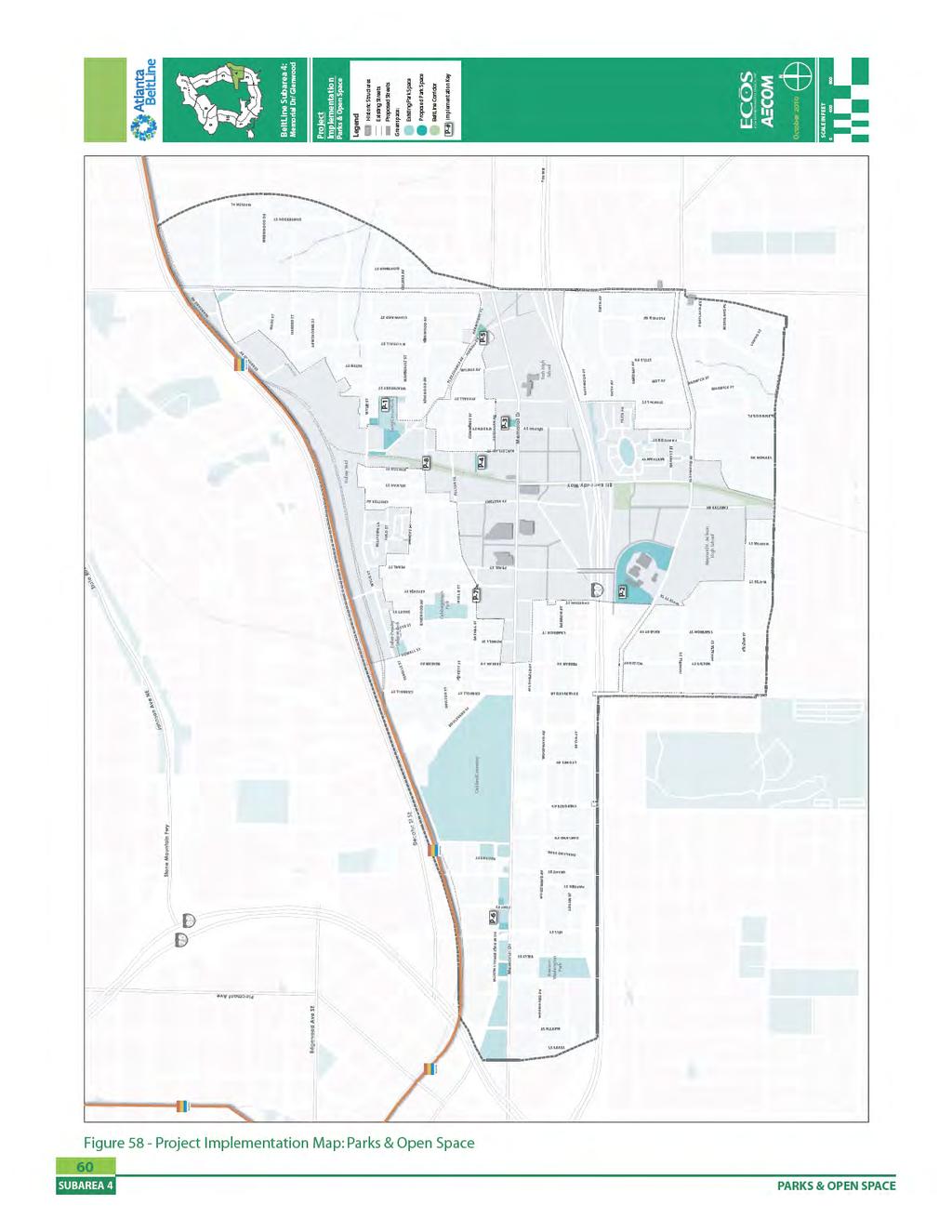
88
89 III. Public Involvement Summary a. Process Description Office Hours Community input played an integral role in the development of the Subarea 4 Master Plan. The Memorial-Glenwood Study Area plan was developed with input from the Southeast Atlanta BeltLine Study Group, as well as a Planning Committee established exclusively to review and guide Subarea 4 planning activities. Additionally, information regarding the planning effort was presented at citywide forums such as Atlanta BeltLine Quarterly Briefings and the website. Study Groups The Atlanta BeltLine is divided into five Study Groups for public involvement activities: Northeast, Northside, Southeast, Southwest and Westside. These groups provide input on the planning and implementation of the project within a specific geographic area. Study Group boundaries are based on recognized neighborhood boundaries and major physical dividers such as interstate highways, and include neighborhoods and business districts. The BeltLine Study Groups are open to all members of the community. Planning Committee To augment the Study Groups, a Planning Committee was created. Planning Committee representatives provided more detailed involvement and continual input throughout the subarea planning process. The Subarea 4 Planning Committee included neighborhood residents, development community interests, property owners, and other key stakeholders. Office Hours are a citizen participation opportunity where interested groups may schedule appointments to meet with Atlanta BeltLine staff to further review, ask questions, and provide input and recommendations to the draft master planning documents for consideration in finalizing the plans. The office hours focusing on the Memorial-Glenwood Subarea were held in October Quarterly Briefings Four times a year, ABI convenes a Quarterly Briefing and invites the general public to learn about recent BeltLine developments and to respond to inquiries from Atlanta residents. These briefings usually consist of a two hourlong session at Atlanta Public Schools or another suitable venue. The consultant team supported the overall Citizen Participation Framework outlined in the 5-year Work Plan and approved by Atlanta City Council in July Specifically, consultant team members, under the direction of project managers from Atlanta BeltLine Inc./Office of Planning, attended both Study Group and Planning Committee meetings and led discussions of land use, circulation, mobility, and parks. There were two Planning Committee meetings and four Study Group meetings held over the course of the planning process. The agendas and meeting notes for each of these meetings are included within Appendix D. The following list includes the meeting date and topic of all Southeast Study Group and Planning Committee meetings held during the planning process. ATLANTA BELTLINE MASTER PLAN July 18,
 May 10, 2010: Study Group Meeting, Review and Discuss Concept Plans d.) June 21, 2010: Planning Committee Meeting, Study Area Master Plan Draft e.")
90 a.) March 15, 2010: Planning Committee Meeting, Kickoff Meeting and Evaluation Framework b.) April 19, 2010: Study Group Meeting, Study Area Existing Conditions, Refine Goals and Objectives c.) May 10, 2010: Study Group Meeting, Review and Discuss Concept Plans d.) June 21, 2010: Planning Committee Meeting, Study Area Master Plan Draft e.) July 12, 2010: Study Group Meeting, Study Area Master Plan Final Draft f.) August 9, 2010: Study Group Meeting, Study Area Master Plan Revised Final Draft g.) September 2010: Office Hours, Various Topics b. Major Themes and Issues Throughout the course of the master planning process many important themes and issues were brought to the attention of Atlanta Beltline planners by community members and stakeholders. The BeltLine community engagement process gathered input from the community in order to help formulate the study area recommendations. The Subarea 4 master planning effort yielded the following major themes: Pedestrian safety and orientation. The study area s Memorial, Moreland, and Boulevard corridors are relatively pedestrian unfriendly. When combined with the numerous unsafe crossings over Interstate 20, it adds up to one of the greatest community concerns for improved pedestrian facilities and greater pedestrian safety. Since making it safe and enjoyable for the nearby neighborhoods to walk to the future transit is one key factor for a successful BeltLine transit system, this master plan contains numerous pedestrian and bicycle improvements including intersection redesigns, sidewalk and streetscape projects, and multi-use trails. The plan also recommends a re-orientation of new development to better address the street, include improved sidewalk environments, and balance all modes of access. Traffic congestion. Many participants were concerned about existing and future traffic congestion. This plan looked at a wide range of solutions and mitigating improvements to relieve traffic congestion. This included providing alternatives to driving such including BeltLine transit and trails, sidewalk improvements and streetscapes. The plan also includes new street connections to improve local accessibility, creates opportunities for shorter trips through compact, mixed-use redevelopment, and slows traffic through traffic calming and intersection improvements. Feedback received from Study Group Meetings played an instrumental role in the planning process. 62 PUBLIC INVOLVEMENT
Atlanta BeltLine Subarea 3 Master Plan Update
 Atlanta BeltLine Subarea 3 Master Plan Update April 14, 2018 Workshop Meeting 1 22 miles, connecting 45 neighborhoods 22 MILES of transit 46 MILES of streetscapes and complete streets 33 MILES of urban
Gold Line Bus Rapid Transit Transit Oriented Development (BRTOD) Helmo Station Area Plan
 Helmo Station Area Plan") Appendix F Gold Line Bus Rapid Transit Transit Oriented Development (BRTOD) Helmo Station Area Plan Introduction and Purpose of the Plan The Gold Line Bus Rapid Transit facility is an eleven-mile dedicated
Appendix F Gold Line Bus Rapid Transit Transit Oriented Development (BRTOD) Helmo Station Area Plan Introduction and Purpose of the Plan The Gold Line Bus Rapid Transit facility is an eleven-mile dedicated
Atlanta BeltLine. Subareas 9 & 10. Master Plan Updates. March 26, Washington Park Jamboree 1
 Atlanta BeltLine Subareas 9 & 10 Master Plan Updates March 26, 2018 Washington Park Jamboree 1 22 miles, connecting 45 neighborhoods 22 MILES of transit 46 MILES of streetscapes and complete streets 33
Midtown Greenway Land Use and Development Plan Executive Summary
 Midtown Greenway Land Use and Development Plan Executive Summary Introduction The Midtown Greenway Land Use and Development Plan sets policy direction for land use and development in the Midtown Greenway
Corridor Vision. 1Pursue Minnehaha-Hiawatha Community Works Project. Mission of Hennepin County Community Works Program
 1Pursue Minnehaha-Hiawatha Community Works Project Minnehaha-Hiawatha Community Works is a project within the Hennepin Community Works (HCW) program. The mission of the HCW program is to enhance how the
Tyvola & Archdale Transit Station Area Plan. May 15, 2008
 Tyvola & Archdale Transit Station Area Plan First Public Meeting May 15, 2008 Presentation Outline 1. Purpose and Process 2. Station Area Overview 3. Plan Recommendations Vision Land Use Transportation
Town Center (part of the Comprehensive Plan)
") Town Center (part of the Comprehensive Plan) Mercer Island Town Center Looking North (2014) In 1994, a year-long process culminated in a set of design guidelines and code requirements for the Town Center
Town Center (part of the Comprehensive Plan) Mercer Island Town Center Looking North (2014) In 1994, a year-long process culminated in a set of design guidelines and code requirements for the Town Center
Table of Contents. Elm Avenue Improvement Plan City of Waco, Texas. Introduction 1. Existing Context 1 Figure 1 2.
 Table of Contents Introduction 1 Existing Context 1 Figure 1 2 Plan Guidelines 3 Future Urban Form 4 The West-End 4 Main Street 6 The East-End 7 Figure 2 9 Public Improvement Recommendations 7 General
FUTURE LAND USE ELEMENT
 FUTURE LAND USE ELEMENT GOAL I: To create and sustain a great place to live, play, and prosper Objective 1: The City of Ocala shall incorporate the principles and strategies of the Ocala 2035 Vision into
ELMVALE ACRES SHOPPING CENTRE MASTER PLAN
 ELMVALE ACRES SHOPPING CENTRE MASTER PLAN Contents 1.0 INTRODUCTION... 2 2.0 LOCATION... 2 3.0 EXISTING CONTEXT... 2 4.0 VISION & GUIDING PRINCIPLES... 2 5.0 LAND USE AND BUILT FORM... 4 5.1 St. Laurent
The transportation system in a community is an
 7 TRANSPORTATION The transportation system in a community is an important factor contributing to the quality of life of the residents. Without a sound transportation system to bring both goods and patrons
Urban Design Manual PLANNING AROUND RAPID TRANSIT STATIONS (PARTS) Introduction. Station Study Areas
 Introduction. Station Study Areas") 111111 PLANNING AROUND RAPID TRANSIT STATIONS (PARTS) Introduction The ION rapid transit system will link Waterloo, Kitchener and Cambridge through a central transit corridor (CTC). There are a number
111111 PLANNING AROUND RAPID TRANSIT STATIONS (PARTS) Introduction The ION rapid transit system will link Waterloo, Kitchener and Cambridge through a central transit corridor (CTC). There are a number
THE NEIGHBORHOOD TODAY
 THE NEIGHBORHOOD TODAY CORE AREA VISION How are we Good Urbanism A Site s DNA thinking about Elements of great Unique elements urban communities embedded in a place the site and design? ELEMENTS LIKE:
Scope of Services. River Oaks Boulevard (SH 183) Corridor Master Plan
 Corridor Master Plan") Scope of Services River Oaks Boulevard (SH 183) Corridor Master Plan PROJECT AREA The project area consists of the River Oaks Boulevard (SH 183) corridor bounded by SH 199 at the northern end and the Trinity
Scope of Services River Oaks Boulevard (SH 183) Corridor Master Plan PROJECT AREA The project area consists of the River Oaks Boulevard (SH 183) corridor bounded by SH 199 at the northern end and the Trinity
Planning Districts INTRODUCTION
 INTRODUCTION To facilitate detailed examination of development prospects for all areas of the community, Delano has been divided into 14 planning districts. The location of these planning districts is
Civic Center District
 Civic Center District The Civic Center district is the civic and social heart of Warrenville, containing such public buildings as the City Hall, Warrenville Public Library, Police Station, Park District
Small Area Plan. South Gateway
 Small Area Plan Adopted May 12, 2008 South Gateway Purpose. The South Gateway Small Area Plan defines the City s expectations for the future of the southern entrance to the City at Interstate 85 and Highway
Regency Developments. Urban Design Brief. Holyrood DC2 Rezoning
 Regency Developments Urban Design Brief Holyrood DC2 Rezoning Stantec Consulting Ltd. 7-31-2017 1. Overview Regency Developments intends to rezone the lands located at 8510 and 8511 93 Avenue, within the
City of Heath. Town Center Concept
 In the give-and-take of getting projects designed, financed, and approved, the famous refrain from the film Field of Dreams is heard often: if you build it, they will come. From the perspective of the
greenprint midtown SUSTAINABILITY ACTION PLAN 2012
 greenprint midtown SUSTAINABILITY ACTION PLAN 2012 MIDTOWN ALLIANCE SOUTHFACE ENERGY INSTITUTE RENAISSANCE PLANNING GROUP SUSTAINABLE ATLANTA PERKINS+WILL 2 GREENPRINT MIDTOWN 1. Introduction Sustainability
EXISTING COMPREHENSIVE PLAN
 EXISTING COMPREHENSIVE PLAN Town Center Land Use Element: V. LAND USE POLICIES Town Center Mercer Island's business district vision as described in "Your Mercer Island Citizen-Designed Downtown" was an
City of Long Beach. creating vibrant and exciting places
 City of Long Beach creating vibrant and exciting places Land Use Element Urban Design Element Overview of the two draft General Plan elements Discuss areas of change Economic goals of the plans Case study
Atlanta BeltLine, Inc. Pathways to Urban Sustainability
 Atlanta BeltLine, Inc. Pathways to Urban Sustainability September 30, 2010 WHAT IS THE ATLANTA BELTLINE? Transit 22-mile loop Parks 1300 + new acres Trails 33 miles Jobs & Economic Development 20 areas,
CHAPTER 7: Transportation, Mobility and Circulation
 AGLE AREA COMMUNITY Plan CHAPTER 7 CHAPTER 7: Transportation, Mobility and Circulation Transportation, Mobility and Circulation The purpose of the Transportation, Mobility and Circulation Chapter is to
URBAN DESIGN BRIEF. 2136&2148 Trafalgar Road. Town of Oakville
 URBAN DESIGN BRIEF 2136&2148 Trafalgar Road Town of Oakville Prepared By: METROPOLITAN CONSULTING INC For 2500674 Ontario Inc November 2016 TABLE OF CONTENTS Page No. 1.0 Introduction/Description of Subject
DRAFT City of Titusville 2040 Comprehensive Plan Future Land Use, Housing, and Transportation Elements April 16, 2018
 DRAFT City of Titusville 2040 Comprehensive Plan Future Land Use, Housing, and Transportation Elements April 16, 2018 Prepared by Canin Associates for the City of Titusville About the Comprehensive Plan:
Murphy Crossing Site Redevelopment Community Engagement Meeting September 19, 2016
 Murphy Crossing Site Redevelopment Community Engagement Meeting September 19, 2016 SUMMARY 1 EXECUTIVE SUMMARY STATEMENT OF PURPOSE ABI has conducted a detailed study of 1. Market potential 2. Building
DRAFT Subject to Modifications
 TREASURE COAST REGIONAL PLANNING COUNCIL M E M O R A N D U M To: Council Members AGENDA ITEM 8 From: Date: Subject: Staff May 19, 2017 Council Meeting Florida Department of Transportation Complete Streets
Tyvola & Archdale Transit Station Area Plan. June 5, 2008
 Tyvola & Archdale Transit Station Area Plan Second Public Meeting June 5, 2008 Presentation Outline 1. Purpose and Process 2. Station Area Overview 3. Plan Recommendations 4. Comments Received and Proposed
DRAFT. October Wheaton. Design Guidelines
 October 2011 DRAFT Wheaton Design Guidelines 2 Draft - Design Guidelines - Wheaton Sector Plan Contents 04 Section 1: Introduction 06 Section 2: Context 08 Section 3: Design Guidelines 09 Goal 1: Create
Complete Neighbourhood Guidelines Review Tool
 Complete Neighbourhood Guidelines Review Tool Prepared By: City of Regina Planning Department October 2014 Page 1 of 14 Community Development Review Checklist for Secondary Plans and Concept Plans The
6. DOWNTOWN. The Downtown Element focuses on supporting and expanding the vitality and enhancement of Downtown Chico as the City s central core.
 VISION In 2030, Downtown Chico is the heart of the community and the center of cultural activity. Engaging and active at the street level, it is a multi-story, mixed-use hub, with specialty retail, restaurants,
Dyersville Downtown Plan. Open House October 24, 2017
 Dyersville Downtown Plan Open House October 24, 2017 What is a Comprehensive Plan? - Vision - Guidance for decisions - Basis for regulations What is a Downtown Plan? - Understand priorities - Identify
ROBBINSDALE LRT STATION CDI DEVELOPMENT GUIDELINES
 August 2018 OVERVIEW The City of Robbinsdale has a prime-opportunity site in the middle of the 13 mile stretch of the Bottineau LRT corridor / Blue Line extension. Robbinsdale offers a prominent, vital,
CITY OF PUYALLUP. Background. Development Services
 CITY OF PUYALLUP Development Services 333 South Meridian Puyallup WA 98371 To: City Council From: Katie Baker, AICP, Planning Division Re: South Hill Neighborhood Plan Adoption Date: (Meeting date: February
Chapter 1.0 Introduction
 Chapter 1.0 Introduction 1.1 Background The North Metro commuter rail line is part of the RTD FasTracks regional transit system expansion program to build more than 100 miles of rail transit throughout
The Five Components of the McLoughlin Area Plan
 The Five Components of the McLoughlin Area Plan This documents contains the complete language of the five components of the McLoughlin Area Plan: The Vision Statement The Values The Guiding Principles
St. Kevin s Area Planning Collaborative
 Table of Contents page 2 EXECUTIVE SUMMARY 3 MISSION STATEMENT 4 NEIGHBORHOOD CONTEXT 6 STREET CHARACTER 7 SITE PARAMETERS 9 COMMUNITY CHARRETTE - VISIONING GROUP TABLE 1 11 GROUP TABLE 2 12 GROUP TABLE
Land Use. Hardware Street Vendor Mixed-Use
 Land Use Definition Land Use is the way a piece of real estate is utilized. Existing, proposed, and adopted land uses all play a role in the planning process. Once a land use plan is adopted, the next
A P P E N D I X B - O P P O R T U N I T Y S I T E S
 A P P E N D I X B - O P P O R T U N I T Y S I T E S OPPORTUNITY SITES As listed in the Land Use Element, the City has identified 15 Opportunity Sites expected to be the focus of change and revitalization
C. Westerly Creek Village & The Montview Corridor
 C. Westerly Creek Village & The VISION Community Vision When the goals of the city are achieved Westerly Creek Village, a distinctive community defined by Montview Boulevard and Westerly Creek, is a strong
Robbinsdale LRT Station. CDI Development Guidelines. August Overview
 Robbinsdale LRT Station August 2018 Overview The City of Robbinsdale may have the coolest opportunity site along the 13 mile stretch of the Bottineau LRT corridor / Blue Line extension. Located a block
Introduction. Chapter 1. Purpose of the Comprehensive Plan Plan Organization Planning Process & Community Input 1-1
 Chapter 1 Introduction Lakewood 2025: Moving Forward Together Purpose of the Comprehensive Plan Plan Organization Planning Process & Community Input 1-1 Purpose of the Comprehensive Plan The Comprehensive
ESTABLISH AN EFFICIENT TOWN CENTER
 ESTABLISH AN EFFICIENT TOWN CENTER 4 Overview Lisbon residents are proud of the history of Newent and at the same time recognize its current importance as a centralized location for a variety of municipal
A. Background Summary of Existing Challenges and Potential Possibilities. 1. Summary of Existing Assets and Potential Opportunities
 A. Background 1 A Main Street Master Plan Study was performed and completed in October of 2007. The study was initiated to review current land uses and development patterns along Main Street, from Parrish
TEMPLE MEDICAL & EDUCATION DISTRICT
 City of Temple, Texas TEMPLE MEDICAL & EDUCATION DISTRICT 1 Description. The City of Temple joined in partnership with key public and private entities to jointly promote education and medical activities
Subareas 9 & 10 Master Plan Updates
 Atlanta BeltLine Subareas 9 & 10 Master Plan Updates Study Group Meeting 4 September 17, 2018 Washington Park Jamboree 1 22 miles, connecting 45 neighborhoods 22 MILES of transit 46 MILES of streetscapes
BeltLine Corridor Environmental Study
 BeltLine Corridor Environmental Study Citywide Conversation on Transit and Trails April 2, 2009 Agenda & Introductions Introductions Environmental Study Process Overview of the BeltLine Project BeltLine
4.1.3 LAND USE CATEGORIES
 4.1.3 LAND USE CATEGORIES a. City Center District The City Center District incorporates the existing character and mix of uses in downtown Belmont to encourage redevelopment and new development in keeping
Staff Report and Recommendation
 Community Planning and Development Planning Services 201 W. Colfax Ave., Dept. 205 Denver, CO 80202 p: 720.865.2915 f: 720.865.3052 www.denvergov.org/cpd TO: City Council Neighborhoods and Planning Committee
V. Vision and Guiding Principles
 V. Vision and Guiding Principles The Master Plan for the Powers Ferry Corridor seeks a foundation in the desires of the community. At times, various elements of the community offered opposing viewpoints,
Implementation Guide Comprehensive Plan City of Allen
 Implementation Guide 2030 Comprehensive Plan City of Allen DRAFT 2015 Implementation Guide Allen 2030 Comprehensive Plan INTRODUCTION The Comprehensive Plan serves as a guide for the growth and development
Beachside Redevelopment Committee
 Beachside Redevelopment Committee DRAFT FINAL RECOMMENDATIONS MARCH 22, 2018 This is a new slide 2 This is a new slide Table of Contents I. Introduction and Overview II. III. Community Improvements and
Rio/29 Small Area Plan. Design Plan & Implementation Framework Open House - January 25, 2018
 Rio/29 Small Area Plan Design Plan & Implementation Framework Open House - January 25, 2018 MEETING PURPOSE PRESENTATION 1. Orient to the updated design plans 2. Introduce implementing options 3. Explain
City of Nogales General Plan
 Open Space, Parks, Recreation and Trails City of Nogales General Plan Residents of Nogales place a high priority in the development of a comprehensive system of open space, parks, recreation and trails
The Atlanta BeltLine. Quarterly Briefing March @atlantabeltline. Reynoldstown Senior Affordable Housing
 The Atlanta BeltLine Quarterly Briefing March 30, 2017 @atlantabeltline @atlantabeltline @atlantabeltline Reynoldstown Senior Affordable Housing Framework for a multi-use and transit corridor in the heart
Policies and Code Intent Sections Related to Town Center
 Policies and Code Intent Sections Related to Town Center The Town Center Vision is scattered throughout the Comprehensive Plan, development code and the 1994 Town Center Plan. What follows are sections
City of Hermosa Beach Administrative Policy #
 City of Hermosa Beach Administrative Policy # SUBJECT: Living Streets Policy Date: Approved by: City Council Authority: Public Works Department & Community Development Department Mayor, PURPOSE The City
Ivywild On The Creek PRELIMINARY CREEK DISTRICT MASTER PLAN
 Ivywild On The Creek PRELIMINARY CREEK DISTRICT MASTER PLAN Introduction: Rejuvenating an extraordinary Creekside neighborhood THE CREEKSIDE DISTRICT The Ivywild On The Creek Neighborhood District Master
Chapter 1: Introduction
 Chapter 1: Introduction The Penn Avenue Community Works Corridor Vision and Implementation Framework presents an integrated communitybased vision and a coordinated, long-term implementation framework for
WEST OAKLAND SPECIFIC PLAN & DRAFT ENVIRONMENTAL IMPACT REPORT
 WEST OAKLAND SPECIFIC PLAN & DRAFT ENVIRONMENTAL IMPACT REPORT Landmarks Preservation Advisory Board Public Hearing February 10, 2014 1 Specific Plan Overview Plan Area is generally bounded by I-580 to
A BLUEPRINT FOR BROCKTON A CITY-WIDE COMPREHENSIVE PLAN
 A BLUEPRINT FOR BROCKTON A CITY-WIDE COMPREHENSIVE PLAN Public Meeting October 2016 1 Plan Summary and Discussion Public Meeting May 4 2017 City of Brockton Bill Carpenter, Mayor Department of Planning
Page 1 of 19 URBAN DESIGN FRAMEWORK FOR BOLTON STREET WATERFORD
 Page 1 of 19 URBAN DESIGN FRAMEWORK FOR BOLTON STREET WATERFORD 1.0 Introduction: The relocation of the City Council stores and depot from Bolton Street creates an exciting opportunity for development
Seneca Meadows. Block 4 Locate office, technology, and medical development adjacent to I Screen views of garage structures from I-270.
 Seneca Meadows Seneca Meadows has an industrial park in its southern end and a mixed-use employment area planned for the north end. The district benefits from extensive I-270 visibility, stream valley
LAND USE OVERVIEW WHAT YOU WILL FIND IN THIS CHAPTER
 LAND USE WHAT YOU WILL FIND IN THIS CHAPTER Information about the City s expected population and employment growth. Description and capacity of existing and future land use designations. Policies that
Chapter 4. Linking Land Use with Transportation. Chapter 4
 Chapter 4 Linking Land Use with Transportation Chapter 4 59 Chapter 4 Linking Land Use with Transportation Community Design and Transportation Program Introduction Since the 1950s, the predominant development
Public input has been an important part of the plan development process.
 Lakewood s Comprehensive Plan recognizes that transportation helps shape the community, and that the way the community provides for the safe and efficient movement of people affects the character of the
S A C R A M E N T O C O U N T Y JACKSON HIGHWAY & GRANT LINE EAST VISIONING STUDY
 JACKSON HIGHWAY & GRANT LINE EAST S A C R A M E N T O C O U N T Y P L A N N I N G D E P A R T M E N T SUMMARY AND WORKBOOK November 19, 2008 History of the Visioning Study Sacramento County has two growth
City of Farmington. Downtown Plan. Amendment to the 1998 Master Plan Adopted October 11, 2004
 City of Farmington Amendment to the 1998 Master Plan Adopted October 11, 2004 Introduction Planning Background 1 Scope and Components of the Plan Amendment 2 Concept Introduction 3 Plan Concepts 3 Conceptual
ARTICLE 6: Special and Planned Development Districts
 ARTICLE 6: Special and Planned Development Districts 6-10 Traditional Neighborhood Development (TND) District 6-10.10 Purpose and Intent The Traditional Neighborhood Development (TND) District provides
Port Lavaca Future Land Use
 Port Lavaca Future Land Use Introduction The City of Port Lavaca is beginning to see sustained growth, after many years of relative stable population. New single family homes, apartments, and businesses
ARLINGTON COUNTY, VIRGINIA
 ARLINGTON COUNTY, VIRGINIA County Board Agenda Item Meeting October 15, 2005 DATE: September 28, 2005 SUBJECT: Request to Advertise the adoption of the 2005 Clarendon Sector Plan C. M. RECOMMENDATION:
Windsor Locks Transit-Oriented Development Planning Grant Request. Project Background
 Windsor Locks Transit-Oriented Development Planning Grant Request Project Background Downtown Windsor Locks runs along Main Street in the vicinity of the intersection of Routes 159 and 140. The current
A. WHAT IS A GENERAL PLAN?
 I. Introduction A. WHAT IS A GENERAL PLAN? A general plan is the planning guideline for the future of a city. It contains goals and policies which regulate urban development, the protection of the natural
Review of Opportunity Area C Draft Comprehensive Plan and Draft BOS Follow-On Motions. Special Working Group Meeting March 4, 2015
 Review of Opportunity Area C Draft Comprehensive Plan and Draft BOS Follow-On Motions Special Working Group Meeting March 4, 2015 The slides that follow identify where the draft Comprehensive Plan has
Study Area. Capitol Way. Greening America s Capitals 11/13/2014. A Greening America s Capitals Project
 Olympia, WA: Greening Capitol Way Supporting Communities move towards sustainability is a priority for the federal government. A Greening America s Capitals Project Office of Sustainable Communities U.S.
Executive Summary. The Mebane CLP is not a regulatory document, but is intended to guide land development decisions. The plan includes:
 Executive Summary P URPOSE AND O RGANIZATION OF THE P LAN The City of Mebane, with input from citizens and an appointed CLP Advisory Committee, adopted Mebane by Design, a Comprehensive Land Development
Making Transit Oriented Development Work For Boonton, NJ
 Making Transit Oriented Development Work For Boonton, NJ Bloustein School of Planning and Public Policy Studio Dan Burton Loannie Dao Webster Slater Brandon Williams Ian Watson Maria Laham Nicola Mammes
THE POLICY FRAMEWORK FOR WALKABLE COMMUNITIES. Community Technical Assistance Program Building Active Communities Institute March 2016
 THE POLICY FRAMEWORK FOR WALKABLE COMMUNITIES Community Technical Assistance Program Building Active Communities Institute March 2016 ACTIVE COMMUNITIES BACK THEN ACTIVE COMMUNITIES BACK THEN Lifestyle
Plano Tomorrow Vision and Policies
 Plano Tomorrow Vision and Policies PLANO TOMORROW PILLARS The Built Environment The Social Environment The Natural Environment The Economic Environment Land Use and Urban Design Transportation Housing
Tonight s Agenda. Summary Presentation Open House. Group Discussion Next Steps: online community wide survey
 Community Open House February 22, 2018 Tonight s Agenda Summary Presentation Open House Station 1: Project Overview and Community Input Station 2: Draft Vision and Guiding Principles Station 3: Western,
DRAFT ROOSEVELT ROAD. District Recommendations. Figure 5.23 The Roosevelt Road Corridor
 CHAPTER 5 Figure 5.23 The Road Corridor Road will develop as a mixed-use corridor, emphasizing regional retail, west of the river and mixed-use development east of the river. KEY RECOMMENDATIONS 1. High
City Center Specific Plan Amendments And Background Report City of Richmond. PLANNING COMMISION FINAL DRAFT January, 2001
 City Center Specific Plan Amendments And Background Report City of Richmond PLANNING COMMISION FINAL DRAFT January, 2001 TABLE OF CONTENTS Page LIST OF TABLES... LIST OF FIGURES... INDEX... OVERVIEW...
WELCOME and introduction
 1 WELCOME and introduction Mobility Hub Locations within Burlington STUDY OVERVIEW STUDY OBJECTIVES The City of Burlington is developing four Area Specific Plans, one for each of Burlington s Mobility
DRAFT Land Use Chapter
 Stevens Creek Urban Village DRAFT 1 18 17 Land Use Chapter INTRODUCTION This Land Use Chapter describes how the Stevens Creek Urban Village will accommodate the growth that is planned for it in the Envision
Mark-up of the effect of the proposed Bronte Village Growth Area OPA No.18 on the text of section 24, Bronte Village, of the Livable Oakville Plan
 Mark-up of the effect of the proposed Bronte Village Growth Area OPA No.18 on the text of section 24, Bronte Village, of the Livable Oakville Plan Notes: This document is provided for information purposes
Allen Street Civic District Redevelopment Area Plan Redevelopment Plan & Proposal State College Planning Commission State College Redevelopment
 Allen Street Civic District Redevelopment Area Plan Redevelopment Plan & Proposal State College Planning Commission State College Redevelopment Authority September 17, 2015 Discussion Points Overview of
This Review Is Divided Into Two Phases:
 Semiahmoo Town Centre Review The purpose of this review: To review the Semiahmoo Town Centre Concept Plan, originally approved in 1993, to ensure that this centre will continue to serve the needs of South
NEIGHBORHOOD DESIGN ELEMENT
 NEIGHBORHOOD DESIGN ELEMENT INTRODUCTION The following recommendations constitute an urban design oriented "neighborhood analysis" of Plantation. It is an optional Comprehensive Plan Element. The five
Transit Implementation Strategy Westside Study Group Meeting
 Westside Study Group Meeting February 27, 2012 The Portland Streetcar Passing Through a Park Near Portland State University Westside Study Group Meeting February 27, 2012 1. TIA Update 2. TIS Process To-Date
Subarea 4 Indian Creek. Vision The combination of park networks and transportation amenities make Subarea 4 the greenest hub in the Corridor.
 indian creek 180 extends south from 101st Street to I-435. The I-435 and Metcalf intersection is one of the primary intersections in the Kansas City Metro Area. The area includes several residential neighborhoods
Asbury Chapel Subdivision Sketch Plan
 Asbury Chapel Subdivision Sketch Plan PART 1: PROJECT SUMMARY Applicant: NVR Inc. Project Size: +/- 76.13 acres Parcel Numbers: 02101112,02116101,02116112, 02116113 Current Zoning: Transitional Residential
BROOKHILL NEIGHBORHOOD MODEL ZONING MAP AMENDMENT PREFACE TO APPLICATION
 BROOKHILL NEIGHBORHOOD MODEL ZONING MAP AMENDMENT PREFACE TO APPLICATION June 15, 2015 Revised: August 1, 2016 I. VISION Brookhill is a proposed community based upon the principles of Albemarle County
The Private Role in a Public-Private Partnership. Ask Me Anything Conference May 30, 2018
 The Private Role in a Public-Private Partnership Ask Me Anything Conference May 30, 2018 1 Thoughts to Share Today Schmit+Associates Essential Elements of a P3 Community Vision Market Demand Economic Viability
North Fair Oaks Community Plan Summary and Information
 North Fair Oaks Community Plan Summary and Information WHAT IS THE NORTH FAIR OAKS COMMUNITY PLAN? The North Fair Oaks Community Plan is part of the San Mateo County General Plan, and establishes policies
Hockessin Community Redevelopment Plan
 Hockessin Community Redevelopment Plan 3.1 Introduction The Community Redevelopment Plan for the Village of Hockessin is the result of the people s vision for a distinct village center that serves as the
Appendix C: Interim Mixed-Use Evaluation Criteria
 Appendix C: Interim Mixed-Use Evaluation Criteria C-1 Appendix C: Interim Mixed-Use Evaluation Criteria PURPOSE: The implementation of numerous policies contained within the Master Plan hinges on the creation
Urban Planning and Land Use
 Urban Planning and Land Use 701 North 7 th Street, Room 423 Phone: (913) 573-5750 Kansas City, Kansas 66101 Fax: (913) 573-5796 Email: planninginfo@wycokck.org www.wycokck.org/planning To: From: City Planning
3.0 PROJECT DESCRIPTION
 3.0 PROJECT DESCRIPTION 3.1 BACKGROUND Under California law (Government Code Section 65300 et seq.), every city and county is required to have a general plan. The general plan is to be comprehensive and
East Central Area Plan
 East Central Area Plan Steering Committee Meeting March 8 th, 2018 CHUN Tears McFarlane House Vision Statement Development Opportunities Analysis Vision Elements 1. Equitable, Affordable and Inclusive