Crenshaw Transit Corridor Alternatives Analysis/EIS/EIR
|
|
|
- Augusta Cole
- 5 years ago
- Views:
Transcription


1 Crenshaw Transit Corridor Alternatives Analysis/EIS/EIR Working Group Meetings South Corridor Meeting Darby Park Wednesday, September 17, :30 8:30 PM Mid-Corridor Meeting Leimert Park Community Build Monday, September 18, :30 8:30 PM Project Information: Information Line:
2 CRENSHAW TRANSIT CORRIDOR PROJECT URBAN DESIGN ANALYSIS Open House 6:30-7:15 Presentation 7:15-8:00 Open House 8:00-8:30

3 REGIONAL CONTEXT MAP Gateway Regional Neighborhood

4 URBAN DESIGN GUIDELINES 1. Local Identity 2. Walkability/ Transit Ties 3. Open Space 4. Mixed Uses 5. Design Quality 6. Defensible Spaces 7. Sustainable Community Crenshaw Transit Corridor Project Urban Design Analysis


5 STATION TYPES At Grade Typical At-Grade LRT Station Metro Example of At-Grade LRT Station, Long Beach

6 STATION TYPES Aerial Typical Aerial LRT & BRT Stations Metro Example of Aerial LRT Station, Chinatown

7 STATION TYPES Below Grade Typical Underground LRT Station Metro Example of an Underground Station, Pershing Square

8 ALIGNMENT PROFILE Crenshaw Transit Corridor
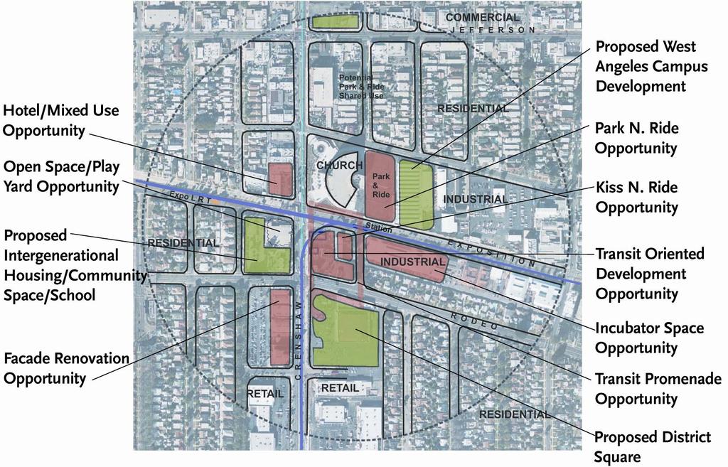
9 Exposition Station

10 Crenshaw Exposition Station Area Concept

11 Exposition Station Existing Crenshaw & Exposition Proposed Crenshaw & Exposition
12 Crenshaw Blvd North of MLK Blvd. Existing, 200 R.O.W. Proposed

13 Champs-Elysees, Paris 228 ROW (Trees About 100 Apart)

14 Baldwin Hills Mall & Leimert Park Village Development Concepts

15 Leimert Park Village Station Area Concept

16 Leimert Park Village Station Area Concept

17 Leimert Park Village (Existing)

18 Leimert Park Village Station Area Concept

19 Crenshaw South of Leimert Park Existing Proposed LRT


20 Crenshaw South of 54 th Street Existing Proposed

21 Slauson Station Enhance safety around View Park Prep School Removal of mature trees in median Opportunity to create transit parkway Opportunity to revitalize existing retail center Opportunity to develop underutilized fast food properties Streetscape improvements along Slauson Avenue Existing city-owned parking lots to be developed


22 Crenshaw south of 58 th Street Existing Proposed


23 Crenshaw south of 60 th Street Existing Sample of Application Of Urban Design Elements
24 LRT Alignment between 60 th Street & Harbor Subdivision R.O.W. Option 1: Raised Platform From 60 th Street to Harbor Subdivision Option 2: On-Grade LRT & 2 Lanes of Traffic Both Ways (Loss of Street Side Parking)


25 Crenshaw at Harbor Subdivision Existing Sample Application of Urban Design Elements

26 West Station Alternative Station Location

27 La Brea Station Bus Transfer & Park & Ride Facility Opportunity County Services Center Opportunity Hi-rise Commercial Development Opportunity Mixed Use/Retail Opportunity Pedestrian Bridge/Pedestrian Promenade Opportunity Retail Development Opportunity Mixed Use Development Opportunity Retail Development Opportunity Theatre Renovation Opportunity Enhance Open Space Opportunity

28 La Brea Station


29 La Brea Station Existing Sample Application of Urban Design Elements

30 Florence La Brea Station

31 Manchester Station Pedestrian linkages & way finding techniques provide a sense of security and enhance pedestrian experience Opportunity for industrial commercial development Opportunity for commercial/retail development Alternative platform location closer to 405 with park & ride

32 Aviation-Century Station (On-grade Station)

33 Aviation-Century Station (Aerial Station)
CRENSHAW TRANSIT CORRIDOR DRAFT EIS/EIR Executive Summary SUMMARY OF IMPACTS. ES.16 Summary of Impacts. Page ES-41
 SUMMARY OF IMPACTS purposes as they are considered in the overall financial capability of Metro along with the other alternatives under consideration. The capital cost methodology and capital cost estimates
Final Environmental Impact Statement/Final Environment Impact Report Appendix K Responses to Comments Received
 Final Environmental Impact Statement/Final Environment Impact Report Response to comment 20-14-H. Please Refer to Master Response 7 regarding safety treatments and approach to safety for the project. Response
APPENDIX J SHPO COORDINATION
 Final Environmental Impact Statement/Final Environment Impact Report Appendix J SHPO Coordination APPENDIX J SHPO COORDINATION August 2011 CRENSHAW/LAX TRANSIT CORRIDOR PROJECT Final Environmental Impact
Crenshaw/LAX Transit Corridor Project
 Crenshaw/LAX Transit Corridor Project Final Environmental Impact Report/ Final Environmental Impact Statement TABLE OF CONTENTS EXECUTIVE SUMMARY August 2011 State Clearing House No. 2007091148 U.S. Department
NEWTONBROOK PLAZA. Aerial of Site SILVERCORE PROPERTIES INC. Wallman Architects
 Aerial of Site Precedents Legacy at Heron s Hill Don Valley Parkway / Sheppard Avenue West ARC Condominiums Bayview Avenue / Sheppard Avenue West Rhythm Condominium Brampton Yonge / Avondale Community
Downtown Elkton Station Area Plan, Elkton, MD. Difficult enough to get support for new starts challenge to fund Houston transit
 Difficult enough to get support for new starts challenge to fund Houston transit More difficult to build Community Support for dense development at station areas Major Concerns: Traffic, Property values,
TRANSIT NEIGHBORHOOD PLANS PROGRAM OVERVIEW
 TRANSIT NEIGHBORHOOD PLANS PROGRAM OVERVIEW OCTOBER 2017 Los Angeles Department of City Planning @LATNP and @Planning4LA Outline Introduction Policy Framework The Transit Neighborhood Plans Program Overview:
Mary Hills Nature Area. Roadway Lighting. The Minneapolis Clinic of Neurology Courage Kenny Rehabilitation Institute
 PUBLIC REALM IMPROVEMENTS Mary Hills Nature Area Enhanced Programming Glenview Terrace Valley View Roadway Lighting Enhanced Streetscape Trail Lighting / Roadway Lighting Wayfinding Public Art The Minneapolis
Panama City Beach Community Redevelopment Agency Condo Con Property Owner Conference & Expo November 14, 2014
 Panama City Beach Community Redevelopment Agency Condo Con Property Owner Conference & Expo November 14, 2014 Front Beach Road CRA On November 30, 2000, the City created the Panama City Beach Community
Final Environmental Impact Statement/Final Environment Impact Report Appendix K Responses to Comments Received
 Final Environmental Impact Statement/Final Environment Impact Report Avenue and Brynhurst Avenue at Florence Avenue. Other measures involve the closing of three intersections at 59th Place, Coliseum Place
Clairtrell Area Context Plan
 Clairtrell Area Context Plan March 2005 Urban Development Services City Planning Contents 1. Introduction... 4 2. Development Structure... 6 2.1 Streets... 7 2.1.1 Sheppard Avenue and Bayview Avenue...
Robbinsdale LRT Station. CDI Development Guidelines. August Overview
 Robbinsdale LRT Station August 2018 Overview The City of Robbinsdale may have the coolest opportunity site along the 13 mile stretch of the Bottineau LRT corridor / Blue Line extension. Located a block
Atlanta BeltLine. Subareas 9 & 10. Master Plan Updates. March 26, Washington Park Jamboree 1
 Atlanta BeltLine Subareas 9 & 10 Master Plan Updates March 26, 2018 Washington Park Jamboree 1 22 miles, connecting 45 neighborhoods 22 MILES of transit 46 MILES of streetscapes and complete streets 33
Northwest Rail Corridor and US 36 BRT Development Oriented Transit Analysis 4.4 STATION AREA FINDINGS
 4.4 STATION AREA FINDINGS Each station is different, and each one requires a separate set of recommendations based on the vision for the site. This section outlines an initial TOD strategy and recommendations
Subarea 5 Southern Gateway. Vision. Mobility The proposed street network will create developable blocks that are scaled appropriately for the area.
 southern gateway 194 Southern Gateway extends south of I-435 to 123 rd Street and includes the area past the Blue Valley Parkway division. This area is adjacent to major office centers such as the College
Regency Developments. Urban Design Brief. Holyrood DC2 Rezoning
 Regency Developments Urban Design Brief Holyrood DC2 Rezoning Stantec Consulting Ltd. 7-31-2017 1. Overview Regency Developments intends to rezone the lands located at 8510 and 8511 93 Avenue, within the
Eglinton West LRT Update
 Eglinton West LRT Update Community Consultation Update May 16, 2016 Background Rapid transit along Eglinton Ave between Kennedy Station and Pearson Airport was included in the Metrolinx Regional Transportation
N Watt Avenue Corridor Plan. STOREFRONT WORKSHOP May 15-17, 2007
 N Watt Avenue Corridor Plan STOREFRONT WORKSHOP May 15-17, 2007 Workshop Overview May 15 12 & 2 pm General Overview/3D Modeling 4 pm Special Topic: Market Study 6 pm Special Topic: McClellan May 16 12
Appendix D Community Impact Assessment
 Appendix D Community Impact Assessment This page is intentionally blank. Mid-City/Exposition Light Rail Transit Project Community Impact Assessment Memorandum for the Improvements at Farmdale Avenue and
Appendix L 2006 LADOT Pedestrian and Traffic Counts
 Appendix L 2006 LADOT Pedestrian and Traffic Counts This page has been intentionally left blank. MTA BOARD MEETING DECEMBER 4, 2003 M etropoli tan Transportation Authority One Gateway Plata Los Angeles,
3.0 PROJECT DESCRIPTION
 3.0 PROJECT DESCRIPTION This chapter provides a detailed description of the proposed West Adams-Baldwin Hills-Leimert New Community Plan (West Adams New Community Plan or proposed project). The project
Eastern Gateway / 7 Corners. City of Falls Church & Fairfax County May 14, 2013
 Eastern Gateway / 7 Corners City of Falls Church & Fairfax County May 14, 2013 Eastern Gateway Concept Plan Current Conditions Vision & Goals Building Potential Transportation Circulator to East Falls
Blue Line LRT Extension
 v e Noble Pkwy Noble Pkwy Xerxes Ave N Shingle Creek Penn Ave N Penn Ave N Fremont Ave N Lyndale Ave N S Washington Ave University Ave NE Blue Line LRT Extension LIGHT RAIL PLATFORM AND STATION DESIGN
METRO Gold Line BRT CBAC Meeting. August 23, 2018
 METRO Gold Line BRT CBAC Meeting August 23, 2018 1 Today s Topics Introductions Corridor Management Committee Update Public Engagement Update History of Alignment Project Scope Discussions Upcoming CBAC
Expo Line Transit Project. Project Status Update Meeting West End Corridor Segment C
 Exposition Light Rail Transit Project Project Status Update Meeting West End Corridor Segment C Culver City Senior Center November 18, 2010 Phase 1 Project Description Phase 1 from Downtown Los Angeles
Planning for TOD Implementation at a Corridor Scale
 Planning for TOD Implementation at a Corridor Scale Bill Sadler, Reconnecting America Presentation to Gold Line Corridor Working Group July 2, 2013 What is Reconnecting America? Reconnecting America is
History: a Grand Urban Boulevard
 History: a Grand Urban Boulevard 1890 1910: At its peak, Euclid Avenue, "Millionaire's Row," was considered the second most beautiful urban street in the country next to Fifth Avenue in Manhattan. 1910-2030:
Screen 1 Corridors and Profiles Evaluated
 Corridors and Profiles Evaluated Universe of Corridors and Profiles Considered CORRIDORS PROFILES I-57 Expressway Halsted Street UP Railroad Wentworth Avenue State Street Michigan Avenue King Drive Cottage
THE GREEN VISION WORKSHOP Friday, November 6, 2009
 THE GREEN VISION WORKSHOP Friday, November 6, 2009 SUSTAINABLE LONG RANGE PLANNING IN SANTA MONICA Eileen Fogarty Director, Planning and Community Development GREEN BUILDINGS Santa Monica has the most
ITEM #8. Regional Smart Growth Program. Regional Smart Growth Program. Presentation Overview. Coast Highway Vision and Stategic Plan.
 Regional Smart Growth Program Economic Development Commission What is Smart Growth? Adopted as part of the Regional Comprehensive Plan (RCP) RCP provides vision for region based on Smart Growth and sustainability
ELMVALE ACRES SHOPPING CENTRE MASTER PLAN
 ELMVALE ACRES SHOPPING CENTRE MASTER PLAN Contents 1.0 INTRODUCTION... 2 2.0 LOCATION... 2 3.0 EXISTING CONTEXT... 2 4.0 VISION & GUIDING PRINCIPLES... 2 5.0 LAND USE AND BUILT FORM... 4 5.1 St. Laurent
Walnut Creek BART Station
 Walnut Creek BART Station Mixed Use Transit Oriented Project Design Review Commission Study Session May 17, 2006 Applicant: Walnut Creek Transit Lifestyles Associates Joint Venture: Transit Village Associates
SECTION TWO: Urban Design Concepts
 SECTION TWO: Urban Design Concepts The Gardnerville Plan for Prosperity shapes economic opportunities presented by regional growth. The Urban Design Concepts provide policies and concepts for land use,
SHERIDAN PARKING STRUCTURE PUBLIC INFORMATION MEETING November 11, :00 pm - 8:00 pm
 SHERIDAN PARKING STRUCTURE PUBLIC INFORMATION MEETING November 11, 2010 6:00 pm - 8:00 pm 1 Project Area 2 Sheridan Parking Structure RTD Ownership 3 Project Elements Structure and amenities include: 1.
Status Report: MD 355 Project
 Status Report: MD 355 Project OCTOBER 2006 M-NCPPC MONTGOMERY COUNTY PLANNING DEPARTMENT Summary of Community Comments, and break to the Results of the MD 355 Participation Session Brookside Gardens -
Lynn Housing Authority and Neighborhood Development. Washington Street Gateway District Plan A p r i l
 Lynn Housing Authority and Neighborhood Development Washington Street Gateway District Plan A p r i l 2 0 0 8 rendering of sagamore hill from lynnway pedestrian overpass table of contents project area
ROBBINSDALE LRT STATION CDI DEVELOPMENT GUIDELINES
 August 2018 OVERVIEW The City of Robbinsdale has a prime-opportunity site in the middle of the 13 mile stretch of the Bottineau LRT corridor / Blue Line extension. Robbinsdale offers a prominent, vital,
Community Design Plan
 Gardena General Plan 2006 Authority While the is not a required element of a General Plan, it is included because improving the community appearance and image is paramount to the overall quality of life
Transportation. Strategies for Action
 Transportation A major priority for the Overlake Neighborhood is to develop a multimodal transportation system. To achieve this system, a balance has to be found among travel, circulation and access needs;
TECHNICAL SUPPLEMENT 1: LAND USE AND ZONING
 TECHNICAL SUPPLEMENT 1: Albuquerque Rapid Transit Project Prepared for: Prepared by: Parsons Brinckerhoff, Inc. August 2015 TABLE OF CONTENTS 1.0 Project Description... 1 1.1 General Description of Existing
International Blvd. TOD Plan Public Workshop #1
 International Blvd. TOD Plan Public Workshop #1 Add photos or project images September 21 and 22, 2010 Workshop Purpose Introduce the public to the Project Review and discuss the existing conditions analysis
Hockessin Community Redevelopment Plan
 Hockessin Community Redevelopment Plan 3.1 Introduction The Community Redevelopment Plan for the Village of Hockessin is the result of the people s vision for a distinct village center that serves as the
Final Master Plan and Development Control Regulations
 1. INTRODUCTION CHECK LIST a. Introduction b. Table of contents c. Definitions. d. scope of works. 2. FINAL OVERALL MASTER PLAN a. SITE ANALYSIS and OVERVIEW: i. Existing and Proposed Site Plan Levels.
POLICY ADVISORY COMMITTEE
 July 26, 2018 POLICY ADVISORY COMMITTEE ENVIRONMENTAL ANALYSIS PHASE Agenda 1. Welcome and introductions. 2. Overview of project activities. 3. Community Advisory Committee update. 4. Public engagement
A Plan for the Heart of the Region: Tukwila, WA
 : Tukwila, WA 1 The Plan orchestrates the Restructuring of a 1,000-acre Regional Shopping Area into a Social and Symbolic for the Region. REGIONAL CONTEXT Downtown Seattle (Metropolitan ) 20 miles Bellevue
CHAPTER 6 SECTION 4(f ) EVALUATION
 EVALUATION") Final Environmental Impact Statement/Final Environment Impact Report CHAPTER 6 SECTION 4(f ) EVALUATION Final Environmental Impact Statement/Final Environmental Impact Report THIS PAGE INTENTIONALLY BLANK
Final Environmental Impact Statement/Final Environment Impact Report CHAPTER 6 SECTION 4(f ) EVALUATION Final Environmental Impact Statement/Final Environmental Impact Report THIS PAGE INTENTIONALLY BLANK
Tyvola & Archdale Transit Station Area Plan. June 5, 2008
 Tyvola & Archdale Transit Station Area Plan Second Public Meeting June 5, 2008 Presentation Outline 1. Purpose and Process 2. Station Area Overview 3. Plan Recommendations 4. Comments Received and Proposed
Planning for TOD Implementation at a Corridor Scale
 Planning for TOD Implementation at a Corridor Scale Catherine Cox Blair, Reconnecting America Presentation to DRCOG and the Sustainable Communities Initiative May 14, 2012 What is Reconnecting America?
Crenshaw/LAX Transit Project. Construction Update Meeting February 20, 2014
 Crenshaw/LAX Transit Project Construction Update Meeting February 20, 2014 Project Overview 2 Project Overview Advanced Utility Work - Metro Builders Design-Build Contract - Walsh Shea Corridor Constructors
DRAFT ROOSEVELT ROAD. District Recommendations. Figure 5.23 The Roosevelt Road Corridor
 CHAPTER 5 Figure 5.23 The Road Corridor Road will develop as a mixed-use corridor, emphasizing regional retail, west of the river and mixed-use development east of the river. KEY RECOMMENDATIONS 1. High
City of Long Beach. creating vibrant and exciting places
 City of Long Beach creating vibrant and exciting places Land Use Element Urban Design Element Overview of the two draft General Plan elements Discuss areas of change Economic goals of the plans Case study
Yonge Eglinton Centre Urban Design Guidelines
 Yonge Eglinton Centre Urban Design Guidelines City Planning Urban Design January 2009 YONGE EGLINTON CENTRE INTRODUCTION.................................................... 1 GENERAL SITE PLAN OBJECTIVES......................................
Lower Merion Commercial Districts Issues and Characteristics Handbook November 2013
 Lower Merion Commercial Districts Issues and Characteristics Handbook November 2013 DRAFT TOWNSHIP-WIDE VISION: To maintain and enhance commercial areas to complement the surrounding high-quality residential
WEST LOOP DESIGN GUIDELINES CHECKLIST
 WEST LOOP DESIGN GUIDELINES CHECKLIST Section 1.0 General Strategies 1.1 DESIGN EXCELLENCE: ENCOURAGE HIGH QUALITY AND INNOVATIVE DESIGN OF NEW BUILDINGS WITHIN THE WEST LOOP WITHOUT BEING PRESCRIPTIVE
WHAT WE HEARD REPORT - Summary Bonnie Doon Mall Redevelopment Application (LDA )
") WHAT WE HEARD REPORT - Summary Bonnie Doon Mall Redevelopment Application (LDA18-0184) PROJECT ADDRESS: 1 Bonnie Doon Shopping Centre NW, 8420 85 Street NW & 8715 85 Street NW PROJECT DESCRIPTION: Rezoning
WHAT WE HEARD REPORT - Summary Bonnie Doon Mall Redevelopment Application (LDA18-0184) PROJECT ADDRESS: 1 Bonnie Doon Shopping Centre NW, 8420 85 Street NW & 8715 85 Street NW PROJECT DESCRIPTION: Rezoning
Lakeview. March 18, N. Barry Lyon Consultants Ltd. UEM TMIG
 Lakeview March 18, 2014 N. Barry Lyon Consultants Ltd. UEM TMIG Mississauga s Waterfront A Coordinated Approach mississauga.ca/waterfront Mississauga s Waterfront - Projects Natural Heritage and Urban
Equitable Growth Through TOD Planning
 Equitable Growth Through TOD Planning Community Meeting # 2 November 2017 Goals Objectives Extend investment from downtown Connect neighborhoods physically and economically Enhance places based on local
Sustainable Development Call for Projects Western Infrastructure Project Submissions
 2009-2010 Sustainable Development Call for Projects Western Infrastructure Project Submissions January 20, 2010 2009-2010 SDCFP Summary of Infrastructure Funding Infrastructure Projects Number of Projects
Section4 Design Vision & Implementation Plan
 Section4 Design Vision & Implementation Plan W Woodschurch Rd 4.1 Design Focus Areas The Framework Plan is simply the starting point for directing the design and implementation of a wide range of transportation
MEMORANDUM. This memo deals with proposed amendments to previously issued Development Permit No for Park Royal North.
 MEMORANDUM Date: August 28, 2015 Our File: 1010-20-15-062 To: Design Review Committee From: Lisa Berg, Senior Community Planner Re: Amendment to Development Permit for Park Royal North This memo deals
178 Carruthers Properties Inc.
 178 Carruthers Properties Inc. Planning Rationale for 178 Carruthers Avenue Site Plan Control Application June 2014 Table of Contents 1.0 Introduction 2.0 Overview of Subject Property 3.0 Current Zoning
CITY OF CAMBRIDGE Growth & Intensification Study Secondary Plan Stakeholder Session September 12th, 2016
 CITY OF CAMBRIDGE Growth & Intensification Study Secondary Plan Stakeholder Session September 12th, 2016 Dillon Consulting Limited Watson & Associates Economists Curtis Planning Inc. Tim Welch Consulting
Seneca Meadows. Block 4 Locate office, technology, and medical development adjacent to I Screen views of garage structures from I-270.
 Seneca Meadows Seneca Meadows has an industrial park in its southern end and a mixed-use employment area planned for the north end. The district benefits from extensive I-270 visibility, stream valley
Northwest Corridor LRT Line to Irving/DFW. Mandalay Place HOA February 7, 2005
 Northwest Corridor LRT Line to Irving/DFW Mandalay Place HOA February 7, 2005 Agenda: Introductions North Lake College Station Issues from November Meeting Recommendations Q & A Proposed Grade Separation
ASPEN HILL Minor Master Plan Amendment
 ASPEN HILL Minor Master Plan Amendment Project Briefing Planning Board Agenda Item #7 Andrea Gilles, Area 2 June 5, 2014 Briefing Purpose 1. Follow-up evaluation on Mixed-Use land use in the Minor Amendment
Northwest commuter rail station US 36 BRT. Westminster Station
 Northwest commuter rail station Westminster Station US 36 BRT Westminster Center US 36 & Church Ranch Broomfield Flatiron/96 th St. US 36 & McCaslin Table Mesa Boulder Junction 13-month effort that will
Coast Highway Oceanside, California
 Coast Highway Oceanside, California Coast Highway Plan Zones What We ve Heard - Walkable/Bikeable Community (Senior and Child Friendly) -Wider Sidewalks -Street Trees -Traffic Calming -Bike Lanes -Paseos
Access to the University of North Carolina at Chapel Hill, UNC Hospitals, and Chapel Hill Transit.
 M 1/ 4 1/ 2 E IL M E IL Station Family: County: City: UNC Hospitals WHY THIS STATION? University Village Orange Chapel Hill Access to the University of North Carolina at Chapel Hill, UNC Hospitals, and
Laird in Focus Community Information Session
 Laird in Focus Community Information Session Tuesday, December 5, 2017 St. Anslem Catholic School, 182 Bessborough Drive Session 1: 5:30 pm - Presentation and Question and Answer Period 6:15 pm - Breakout
LOS ANGELES COUNTY METROPOLITAN TRANSPORTATION AUTHORITY (LACMTA)
") CE OF PREPARAT LOS ANGELES COUNTY METROPOLITAN TRANSPORTATION AUTHORITY (LACMTA) NOTICE OF PREPARATION OF AN ENVIRONMENTAL IMPACT STATEMENT (E1S)lENVIRONMENTAL IMPACT REPORT (EIR) TO: AGENCIES, ORGANIZATIONS
CE OF PREPARAT LOS ANGELES COUNTY METROPOLITAN TRANSPORTATION AUTHORITY (LACMTA) NOTICE OF PREPARATION OF AN ENVIRONMENTAL IMPACT STATEMENT (E1S)lENVIRONMENTAL IMPACT REPORT (EIR) TO: AGENCIES, ORGANIZATIONS
1.0 VISION STATEMENT. December 6, PRINCIPLES
 Vision Statement Lincoln Regional Airport 1.0 VISION STATEMENT 1.1 City LOCATION of AND OVERVIEW The Easton Lincoln Place Land Use Master Plan identifies the principles, goals, policies, and standards
Courtice Main Street Study Community Vision Workshop PLANNING SERVICES DEPARTMENT
 Courtice Main Street Study Community Vision Workshop PLANNING SERVICES DEPARTMENT July 22, 2009 Tonight s Meeting 7:00 pm Introduction David Crome, Director of Planning 7:05 Presentation Stasia Bogdan,
SOUTHWEST TRANSITWAY (STAGE 2) PUBLIC OPEN HOUSE
 PUBLIC OPEN HOUSE") WELCOME! SOUTHWEST TRANSITWAY (STAGE 2) PUBLIC OPEN HOUSE Monday, November 18, 2013 3:30 to 5:30PM and 7:00 to 9:00PM Tuesday, November 19, 2013 3:30 to 5:30PM and 7:00 to 9:00PM Welcome to the Southwest
WELCOME! SOUTHWEST TRANSITWAY (STAGE 2) PUBLIC OPEN HOUSE Monday, November 18, 2013 3:30 to 5:30PM and 7:00 to 9:00PM Tuesday, November 19, 2013 3:30 to 5:30PM and 7:00 to 9:00PM Welcome to the Southwest
THE 355/270 CORRIDOR:
 THE 355/270 CORRIDOR: Strategic Ideas for Sustaining a Livable Work Place Project Summary ACCESS LIFE DESIGN HEALTH WORK Montgomery County Planning Department The Maryland-National Capital Park and Planning
LAND USE AMENDMENT DOWNTOWN COMMERCIAL CORE (WARD 7) MACLEOD TRAIL SE AND 5 AVENUE SE BYLAW 254D2017
 MACLEOD TRAIL SE AND 5 AVENUE SE BYLAW 254D2017") Page 1 of 10 EXECUTIVE SUMMARY This Land Use Amendment application seeks to redesignate a full downtown block (currently the YWCA site) from a Direct Control based on the CM-2 District (Land Use Bylaw
Page 1 of 10 EXECUTIVE SUMMARY This Land Use Amendment application seeks to redesignate a full downtown block (currently the YWCA site) from a Direct Control based on the CM-2 District (Land Use Bylaw
THE GAS PLANT DISTRICT MASTER PLAN SCENARIO 2. COMMUNITY MEETING August 6, 2018
 THE GAS PLANT DISTRICT MASTER PLAN SCENARIO 2 COMMUNITY MEETING August 6, 2018 The Gas Plant Neighborhood in the 1970 s The development should honor the history of the Gas Plant neighborhood and the community
NORTH COLLEGE PARK. Residential Neighborhood and Neighborhood Center OBJECTIVES EXISTING SITUATION AND ISSUES CONCEPT
 Greenbelt Metro Area Sector Plan - Subarea Design Policies and Guidelines - North College Park 119 NORTH COLLEGE PARK Residential Neighborhood and Neighborhood Center CONCEPT North College Park is envisioned
WESTSIDE SUBWAY EXTENSION PROJECT. Addendum to the Visual and Aesthetic Impacts Technical Report
 PROJECT to the Visual and Aesthetic Impacts Technical Report August 2011 Visual and Aesthetic Impacts Technical Report SUMMARY On October 28, 2010, the Metro Board selected the Westwood/VA Hospital Extension
1 INTRODUCTION Purpose Project Background PROJECT CONTEXT Background The Capital City Downtown Plan...
 Attachment 3 Contents CONTENTS 1 INTRODUCTION... 3 Purpose... 3 Project Background... 3 2 PROJECT CONTEXT... 9 Background... 9 The Capital City Downtown Plan... 9 The LRT Expansion Plan - LRT Downtown
Corridor Investment Projects (FY FY2012)
") City of Long Beach, California Department of Development Services Corridor Investment Projects (FY1980 - FY2012) Building A Better Long Beach North Long Beach Corridor Investments Bixby Knolls on Long
City of Long Beach, California Department of Development Services Corridor Investment Projects (FY1980 - FY2012) Building A Better Long Beach North Long Beach Corridor Investments Bixby Knolls on Long
Subarea 4 Indian Creek. Vision The combination of park networks and transportation amenities make Subarea 4 the greenest hub in the Corridor.
 indian creek 180 extends south from 101st Street to I-435. The I-435 and Metcalf intersection is one of the primary intersections in the Kansas City Metro Area. The area includes several residential neighborhoods
BROOKLYN PARK / 85TH AVE LRT STATION CDI DEVELOPMENT GUIDELINES DRAFT
 August 2018 Page intentionally left blank The Brooklyn Park Library adjacent to the 85th Ave LRT Station Area. OVERVIEW The Blue Line LRT Extension / Bottineau corridor offers a unique opportunity to leverage
Complete Street and the EA Process. Queen Street Corridor- Brampton Golden Mile
 Complete Street and the EA Process. Queen Street Corridor- Brampton Golden Mile Contents A. Vision B. Overview of Existing Conditions C. Queen Street Complete Street Criteria D. A quick look at the Queen
Eastside Transit Corridor Phase 2 Technical Study Update Community Outreach Meeting February 2017
 Eastside Transit Corridor Phase 2 Technical Study Update Community Outreach Meeting February 2017 Purpose of Tonight s Meeting Recap of Board motion (2014) and technical study process Provide update on
Newton Town Centre. Land Use, Urban Design & Transportation Plan
 Newton Town Centre Land Use, Urban Design & Transportation Plan Public Workshop - June 2-4, 2009 6:15 6:30 Sign-in & conversations Tonight s Agenda 6:30 6:55 Project introduction and summary of previous
Lambeth Main Street Streetscape Improvements
 Lambeth Main Street Streetscape Improvements Open House October 5th, 2017 Agenda 1. Introduction 2. Project Background 3. Context 4. Project Objectives 5. Design Principles & Approach 6. Streetscape Design
Sketch Plan. MNCPPC Plan No: A
 General Notes 1. The Sketch Plan drawings are conceptual only and represent proposed development in an illustrative manner. Final building locations, dimensions, heights, uses and development standards
CHAPTER 5: GUIDING PRINCIPLES
 CHAPTER 5: GUIDING PRINCIPLES The following 10 principles were developed based on public consultation, planning policy and the background analysis conducted during Phase 1. The Guiding Principles significantly
Courthouse Square Planning & Urban Design Study. Courthouse Square Working Group #13 October 15, 2014
 Courthouse Square Planning & Urban Design Study Courthouse Square Working Group #13 October 15, 2014 1 Courthouse Square Process Working Group Community Courthouse Square Advisory Groups & Civic Associations
Route 9 Gateway Project. October 9, 2014 Informational Meeting
 Route 9 Gateway Project NYS DOT P.I.N. 1759.67 Town of Lake George, New York October 9, 2014 Informational Meeting Open House 3:00-3:30 Presentation 3:30-4:15 Introductions Town Representatives Dennis
4.10 LAND USE AND PLANNING
 4.10 LAND USE AND PLANNING This section provides an overview of the existing land uses, land use designations, and planning policy for the West Adams CPA and the surrounding area and evaluates the potential
Public Forum. Kelley s Corner: The Corner that Connects Us. The Cecil Group. March 7, Acton 2020 Town of Acton.
 Public Forum Acton 2020 Town of Acton March 7, 2013 AGENDA Purpose of Forum Kelley s Corner Project Examples of the Planning Processes Next Steps Dialogue: Questions and Answers PURPOSE Acton 2020 April
Welcome to Greenwood Village Corporate Capital of Colorado
 Welcome to Greenwood Village Corporate Capital of Colorado Greenwood Village Setting Incorporated: 1950 Land Area: 8.4 sq. miles + / - Budget $35M Debt $0 Reserve $20M Population Daytime: 50,000 Residents:
Green Gables. April 24, 2013
 Green Gables Preliminary and Final Plat April 24, 2013 Development Team Green Gables Development Corporation (Owner/Developer) DTJ Design (Planner/Landscape Architect) Enertia Consulting Group (Civil Engineer)
Courthouse Square Planning & Urban Design Study Working Group Meeting #11 September 2, 2014
 Courthouse Square Planning & Urban Design Study Working Group Meeting #11 September 2, 2014 1 Study Area Courthouse Square DRAFT Design Concepts A B C 3 Public Feedback July 23 Workshop & Online Survey
BESSARION-LESLIE CONTEXT PLAN
 Development in the Bessarion-Leslie area will be consistent with the following urban design guidelines. They provide a framework for development in the area and are to be read in conjunction with the urban
Knoxville Area Transit (KAT) Transit Development Plan Corridor Analysis
 Transit Development Plan Corridor Analysis") Knoxville Area Transit (KAT) Transit Development Plan Submitted to: Knoxville-Knox County Metropolitan Planning Commission Submitted by: PB Americas, Inc. Under contract to: The Corradino Group, Inc. October
Knoxville Area Transit (KAT) Transit Development Plan Submitted to: Knoxville-Knox County Metropolitan Planning Commission Submitted by: PB Americas, Inc. Under contract to: The Corradino Group, Inc. October
Port Credit Local Advisory Panel October 20 th Meeting
 Port Credit Local Advisory Panel October 20 th Meeting Focus Of This Evening s Meeting: 1. Hurontario Main Street Higher Order Transit Study 2. Port Credit Mobility Hub & GO Station Parking Structure Study
Stakeholders Advisory Working Groups (SAWGs) Smart Growth and TOD Land Use (#11) SAWG Meeting
 Smart Growth and TOD Land Use (#11) SAWG Meeting") Presentation - Part II Tappan Zee Bridge/I-287 Corridor Project July 21, 2010 Slide 1. David Kooris (Regional Plan Association) welcomed members of the Land Use Stakeholders Advisory Working Groups (SAWGs)
Presentation - Part II Tappan Zee Bridge/I-287 Corridor Project July 21, 2010 Slide 1. David Kooris (Regional Plan Association) welcomed members of the Land Use Stakeholders Advisory Working Groups (SAWGs)
Sub Area 2: Downtown Overland Park
 Downtown 132 2.12 encompasses over 600 acres and extends between 71st Street and 87 th Street including Downtown Overland Park. The area is home to several individual historic sites and structures, including