FURTHER TO EXECUTIVE COMMITTEE MEETING #7/11 To be held on August 5, 2011
|
|
|
- Karin McDaniel
- 5 years ago
- Views:
Transcription
1 FURTHER TO EXECUTIVE COMMITTEE MEETING #7/11 To be held on August 5, 2011 FURTHER TO: Pages EX8. SECTION II - ITEMS FOR EXECUTIVE ACTION EX8.2 - LISTED ON AGENDA AS REPORT TO FOLLOW EX DEER VALLEY DRIVE EMERGENCY EROSION CONTROL MAINTENANCE PROJECT Tender PMO11-05 Town of Caledon, Region of Peel 121 EX8.3 - FROM AUTHORITY MEETING #7/11 EX8.3 WILD WATER KINGDOM Request For Approval of Driving Range on Leased Land 126 EX10. APPLICATIONS FOR PERMITS PURSUANT TO ONTARIO REGULATION 166/06 Development, Interference with Wetlands and Alterations to Shorelines and Watercourses ERRATA UPDATE SHEET 131 CITY OF TORONTO [NORTH YORK COMMUNITY COUNCIL AREA] EX10.84 TRANS-NORTHERN PIPELINES INC. To site grade and temporarily or permanently place, dump or remove any material, originating on the site or elsewhere within the existing utility corridor- east of the G. Ross Lord Reservoir, north of Finch Avenue, in the City of Toronto (North York Community Council Area), Don River Watershed as located on property owned by TRCA and Hydro One. The purpose is to undertake pipeline maintenance works within the hydro corridor north of Finch Avenue, east of the G Ross Lord Reservoir. Works will include the excavation and repair of a segment of the existing pipeline. No in-water works are associated with this project. 136
2 TOWN OF MARKHAM EX10.85 REGIONAL MUNICIPALITY OF YORK To construct, reconstruct, erect or place a building or structure on 16th Avenue between Warden Avenue and Kennedy Road, in the Town of Markham, Rouge River Watershed as located on the property owned by Regional Municipality of York. The purpose is to permit the installation of 1.2 kilometers of 750 millimeter diameter watermain along 16th Avenue between Warden Avenue and Kennedy Road, crossing below Berczy Creek and Bruce Creek via horizontal directional drilling, two associated valve chambers, and an air relief valve chamber. The red side dace timing window will be applied to the works. 138 TOWN OF RICHMOND HILL EX10.86 EX ONTARIO INC. C/O LEBOVIC ENTERPRISES To construct, reconstruct, erect or place a building or structure, site grade and alter a watercourse on Lot 64, Concession 1 Block 158, Plan 65M-3801, ( Yonge Street), in the Town of Richmond Hill, Humber River Watershed as located on the property owned by Ontario Inc. c/o Lebovic Enterprises. The purpose is to undertake works within a TRCA Regulated Area in order to facilitate the construction of a 99-unit townhouse development block that includes amphibian crossings and a stormwater outfall. 140 TOWN OF RICHMOND HILL To construct, reconstruct, erect or place a building or structure, temporarily or permanently place, dump or remove any material, originating on the site or elsewhere and alter a watercourse in the area of Verdi Road to Parker Avenue, near Bathurst Street and King Road, in the Town of Richmond Hill, Humber River Watershed as located on the property owned by Town of Richmond Hill and Toronto and Region Conservation Authority. The purpose is to construct approximately 500m of a woodchip trail and 1500m of a limestone screening trail connecting Verdi Road and Parker Avenue north of Poplar Drive in Town of Richmond Hill. The project also includes construction of a 50m asphalt trail in Woodside Park, installation of four boardwalks, three bridges, three culverts and one lookout. Helical pier footings and armourstone retaining walls will be used in bridge construction. A Letter of Advice will be written by TRCA staff on behalf of Fisheries and Oceans Canada (DFO) for this project. The works will occur within an extended Ministry of Natural Resources (MNR) cold water fisheries timing window. 143
3 EX WHITE OAK CRESCENT To construct, reconstruct, erect or place a building or structure, site grade and temporarily or permanently place, dump or remove any material, originating on the site or elsewhere on Lot 11, Plan 65M-2799, (22 White Oak Crescent), in the Town of Richmond Hill, Don River Watershed. The purpose is to acknowledge the construction of a rear deck, path, and gazebo in the rear yard of the existing dwelling within a Regulated Area of the Don River Watershed. The structures were constructed without TRCA or municipal building permits. As such, a permit fee and 'after the fact' fee was paid by the applicant in association with the violation. 148
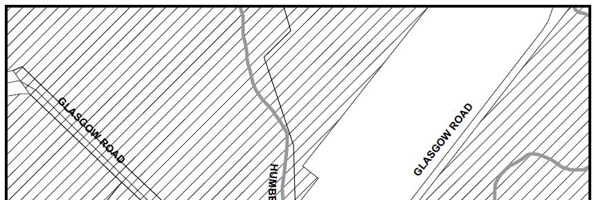
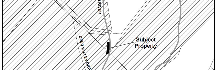
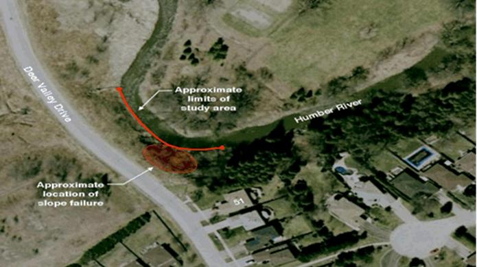
4 TO: FROM: Chair and Members of the Executive Committee Meeting #7/11, August 5, 2011 Nick Saccone, Director, Restoration Services Item EX8.2 RE: 51 DEER VALLEY DRIVE EMERGENCY EROSION CONTROL MAINTENANCE PROJECT Tender PMO11-05 Town of Caledon, Region of Peel KEY ISSUE Award of Contract PMO11-05 for gabion stone. RECOMMENDATION THAT Contract PMO11-05 for the supply and delivery of approximately 6,500 tonnes of 100mm-200mm gabion stone to the 51 Deer Valley Drive Emergency Erosion Control Maintenance Project, Village of Bolton, Town of Caledon, Region of Peel, be awarded to Dale Ottewell Construction & Logging Ltd. for a total unit price of $26.75 per tonne and a total cost not to exceed $173,875.00, plus HST, it being the lowest bid meeting Toronto and Region Conservation Authority (TRCA) specifications; THAT should staff be unable to achieve an acceptable contract with the above-mentioned contractor, staff be authorized to enter into and conclude contract negotiations with other contractors that submitted tenders, beginning with the next lowest bidder meeting TRCA specifications; AND FURTHER THAT authorized TRCA officials be directed to take the action necessary to implement the contract including obtaining needed approvals and signing and execution of documents. BACKGROUND The area of concern is a section of the Humber River located adjacent to the east of the Deer Valley Drive right-of-way and immediately north of the residential property, 51 Deer Valley Drive. The study area is approximately 90 m downstream from the Glasgow Road Bridge, along a bend of the Humber River, approximately 75 m in length. A location map of the study area is shown in Attachment 1. In the spring of 2009, the site was identified to TRCA by the Town of Caledon, and by the residents of 51 Deer Valley Drive. The residents reported the loss of several trees, as well as ongoing crest recession towards the road on the coincident slope adjacent to No. 51 Deer Valley Drive. 120
5 TRCA retained a professional engineering consulting firm, Terraprobe Limited, to complete a geotechnical investigation to determine the potential risk for future slopes failures and any potential impacts to the Deer Valley Drive right-of-way and the residential property (51 Deer Valley Drive). Terraprobe identified that the instability of the slope was a result of the active toe erosion caused by the water flow along the unprotected bank. Terraprobe recommended that bank protection measures be implemented to address possible future localized instability of the slope. Terraprobe confirmed there is potential for future slope failures if no protection works are completed at this site. Terraprobe recommended that the preferred solution is to extend the existing armourstone wall downstream to protect the slope from further toe erosion, thus protecting the property currently at risk. A further geomorphic and hazard assessment on the meander bend and valley wall within the project area completed by Geomorphic Solutions in 2011 confirmed the Terraprobe (2010) findings and noted that the channel at the rear of 51 Deer Valley Drive is migrating laterally at a significant rate. Based on these findings, TRCA is proposing to extend existing erosion control works located both upstream and downstream of 51 Deer Valley Drive in order to address any possible future instability of the right valley wall facing downstream and mitigate the risk to the residential dwelling, existing structures and public safety. In accordance with TRCA s Maintenance and Erosion Control Monitoring Program, the current project will be implemented as part of a maintenance project for the existing bank protection. RATIONALE Tender packages were sent to five (6) suppliers as follows: Glenn Windrem Trucking; Dale Ottewell Construction & Logging Ltd. J.C. Rock Limited; James Dick Company Ltd; Lafarge Aggregates; and Nelson Aggregate Company. Tender PMO11-05 was publicly advertised using the online service Biddingo.com on July 21, The Tender Opening Committee opened tenders on July 29, 2011 with the following results: Tender PMO11-05 Supply and Delivery of Approximately 6,500 Tonnes of 100mm 200mm Gabion Stone BIDDERS TOTAL UNIT PRICE (per tonne) TOTAL VALUE OF CONTRACT (plus HST) Dale Ottewell Construction & $26.75 $173, Logging Ltd. Nelson Aggregate Company $26.90 $174, Glenn Windrem Trucking $28.87 $187,
6 Based on the bids received, staff recommends that Dale Ottewell Construction & Logging Ltd. be awarded Contract PMO11-05 for the supply and delivery of approximately 6,500 tonnes of 100mm -200mm gabion stone for the unit cost of $26.75 per tonne and a total amount not to exceed $173,875.00, plus HST, as they are the lowest bidder meeting TRCA specifications. FINANCIAL DETAILS Funding is available in the Peel Climate Change Mitigation Capital Budget under account code Report prepared by: Aaron D'Souza, extension s: ajdsouza@trca.on.ca For Information contact: Aaron D'Souza, extension 5775 Date: July 20, 2011 Attachments: 2 122
7 Attachment 1 123
8 Attachment 2 124
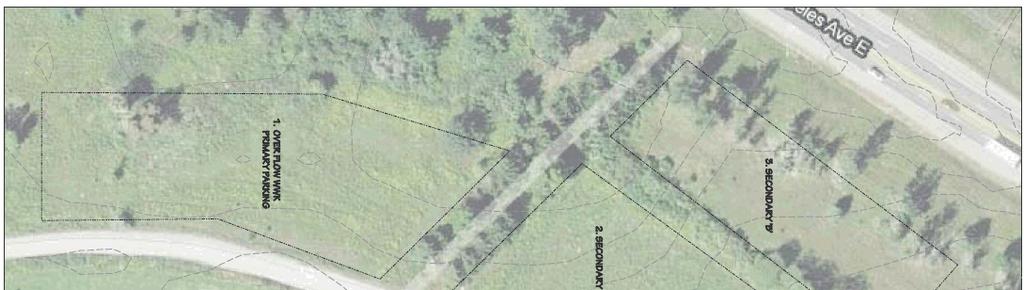
9 TO: FROM: Chair and Members of the Executive Committee Meeting #7/11, August 5, 2011 James W. Dillane, Director, Finance and Business Services Item EX8.3 RE: WILD WATER KINGDOM Request For Approval of Driving Range on Leased Land KEY ISSUE Pursuant to the lease agreement with Toronto and Region Conservation Authority, Wild Water Kingdom is seeking approval for construction of a driving range on the leased lands. RECOMMENDATION WHEREAS at Authority Meeting #7/11, held on July 29, 2011, the staff report dated July 20, 2011 in regard to Wild Water Kingdom was approved, subject to review and approval by the Executive Committee of the tree removal and replacement plan; THEREFORE LET IT BE RESOLVED THAT pursuant to the lease agreement between Toronto and Region Conservation Authority (TRCA) and Wild Water Kingdom Inc. (WWK), construction and operation of a driving range at WWK be approved; THAT the driving range shall be constructed in accordance with regulatory and permit requirements of the City of Brampton and TRCA; THAT WWK shall satisfy all terms and conditions as may be required by TRCA staff; AND FURTHER THAT authorized TRCA officials be directed to the action necessary to implement the lease amendment including obtained needed approvals and signing and execution of documents. BACKGROUND Wild Water Kingdom leases land in the former Claireville Conservation Area adjacent to the Claireville reservoir and immediately north of Indian Line Campground for purposes of operating a water park and ancillary facilities. Under the terms of the lease, major capital development must be approved by the Authority. Wild Water Kingdom is requesting approval of a driving range facility on lands immediately north of the existing WWK parking lot. These lands include the former parking area used by the former Claireville Conservation Area which is presently being used by WWK as overflow parking. At Authority Meeting #7/11, held on July 29, 2011, the Members requested detailed information on the proposal be reviewed by the Executive Committee prior to approval. The Authority granted approval subject to Executive Committee approval, and in addition, at Authority Meeting #9/10, held on November 26, 2010, powers of the Authority were delegated to the Executive Committee for the August 2011 Executive Committee meeting. 125
10 RATIONALE Staff has met with the proponent on site and reviewed with representatives of WWK the location of the proposed driving range and the work required to implement the project. The project involves changes to the existing site: the former parking lot will be leveled to remove the original parking lot dividers (small mounds of earth); the fill will be retained on site; a majority of the area to be leveled is tableland and outside the flood plain, however a small portion of the east end is fill regulated area; some netting will be required but will be at modest heights since the configuration of the site is away from traffic and pedestrian areas; the driving range itself is built on concrete pads which will require minimal excavation; two small prefab structures will be located on the site, one for storage and one for sales and office use; water and electricity are available adjacent to the site; an aborists report has been prepared concerning removal of trees and shrubs from the site; there are three areas that WWK has used in the past for additional overflow parking. Minor work will be done to these areas so that they can be used by WWK to replace the overflow parking lost in construction of the driving range. Staff is recommending approval of the request subject to all terms and conditions of TRCA being satisfied. The site where the driving range is located is disturbed and has been used previously as a parking lot. It appears that tree removal can be minimized, certainly the proponent is anxious to minimize tree removal to reduce the costs of preparation. There appear to be no significant regulatory or flood plain issues but TRCA planning staff will advise. The project is complementary to the existing uses on the site. The project is consistent with the Claireville Master Plan designation for the area to the south of Steeles Avenue. FINANCIAL DETAILS The project cost is entirely the responsibility of WWK. Revenue from the driving range will be included in the revenue of WWK. TRCA receives both a base rent and percentage rent from WWK, the latter based on total gross revenue of all activities at WWK. DETAILS OF WORK TO BE DONE Staff has not received detailed plans and specifications for this work. When received, the plans and specifications will be reviewed and all TRCA requirements will be identified and met prior to TRCA staff granting approval to proceed. Wild Water Kingdom is anxious to have the driving range in place for the fall. This matter is before the Authority on July 29th because no meeting is held in August. 126
11 The driving range is being constructed by AGT Systems Inc. The President of AGT Systems Inc. will be available at the meeting to make a presentation or answer questions if desired by Members. Report prepared by: Jim Dillane, s: jdillane@trca.on.ca For Information contact: Jim Dillane, s: jdillane@trca.on.ca Date: July 20, 2011 Attachment: 2 127
12 Attachment 1 128
13 Attachment 2 129
14 EX10. APPLICATION FOR PERMITS UNDER ONTARIO REGULATION 166/06 Development, Interference with Wetlands and Alterations to Shorelines and Watercourses Information has been received and reviewed by staff for the following Scheduled Errata items. The recommendations within the staff reports should be amended to include the following: EX10.24 ENERSOURCE HYDRO MISSISSAUGA Letter of Undertaking from Enersource Hydro Mississauga committing to provide revisions to engineering and landscape drawings to the satisfaction of TRCA staff for works in the regulated area, received by TRCA on July 28, EX DUNBARTON ROAD Plan showing rear yard deck with dimensions, prepared by Owner, received by TRCA on July 29, 2011; Rear Elevation showing rear yard deck and existing openings to the dwelling, prepared by Owner, received by TRCA on July 29, 2011; Plan showing existing basement layout with dimensions, prepared by Owner, received by TRCA on June 27, 2011; Basement Entrance South Side detail drawing, prepared by Owner, received by TRCA on June 27, 2011; Basement Entrance North and East Sides detail drawing, prepared by Owner, received by TRCA on June 27, EX TAYLORWOOD DRIVE Drawing unnumbered, Site Plan, prepared by Betz Pools, dated July 15, 2011, received on July 15, EX FALLINGBROOK WOODS Letter of Undertaking signed by owner dated August 2, 2011, received August 2, EX10.28 PROLOGIS CANADA Drawing No. CH-1, Proposed Channel, prepared by MMM Group, dated July 28, 2011, received August 2, 2011; Drawing No. ER1, prepared by MMM Group, dated July 28, 2011, received August 2, 2011; Drawing No. A1.1, Site Plan, prepared by Ware Malcomb, dated May 24, 2011, received August 2, 2011; Drawing No. SG2, prepared by MMM Group, dated May 24, 2011, received August 2, 2011; Drawing No. SG4, prepared by MMM Group, dated May 24, 2011, received August 2, 2011; Drawing No. SG5, prepared by MMM Group, dated November 8, 2010, received August 2, 2011; Drawing No. SS2, Site Servicing, prepared by MMM Group, dated May 24, 2011, received August 2, 2011; 130
15 Drawing No. SS4, Site Servicing, prepared by MMM Group, dated May 24, 2011, received August 2, 2011; Drawing No. SWM1, SWM/Wetland Pond, prepared by MMM Group, dated May 24, 2011, received August 2, 2011; Drawing No. NT1, General Notes, prepared by MMM Group, dated March 29, 2011, received August 2, 2011; Drawing No L-1, Landscape Plan, prepared by Juhan Marten, dated May 25, 2011, received August 2, 2011; Drawing No. L-2, Landscape Plan, prepared by Juhan Marten, dated May 25, 2011, received August 2, 2011; Drawing No. L-3, Landscape Details, prepared by Juhan Marten, dated May 25, 2011, received August 2, 2011; Drawing No WL-1, Planting Plan, prepared by MMM Group, dated November 12, 2010, received August 2, 2011; Drawing No. WL-2, Planting Details, prepared by MMM Group, dated November 12, 2010, received August 2, EX10.29 CITY OF TORONTO Letter of Undertaking; dated August 2, 2011; prepared by the City of Toronto; agreeing to provide revised engineering and landscaping drawings to TRCA staff satisfaction; received by TRCA on August 2, EX10.30 CITY OF TORONTO (PARKS FORESTRY AND RECREATION DIVISION) Drawing # 0; Artificial Outdoor Ice Surface at Cedarvale Park Behind Phil White Arena at 443 Arlington Avenue, City of Toronto - Overall Site Plan; prepared by Peter T. Mitches & Associates Limited; on behalf of the City of Toronto; dated June 27, 2011; received by TRCA on July 20, 2011; Drawing # 1; Artificial Outdoor Ice Surface at Cedarvale Park Behind Phil White Arena at 443 Arlington Avenue, City of Toronto - Existing Site Plan; prepared by Peter T. Mitches & Associates Limited; on behalf of the City of Toronto; dated June 27, 2011; received by TRCA on July 20, 2011; Drawing # 1A; Artificial Outdoor Ice Surface at Cedarvale Park Behind Phil White Arena at 443 Arlington Avenue, City of Toronto - Construction Access Road; prepared by Peter T. Mitches & Associates Limited; on behalf of the City of Toronto; dated June 27, 2011; received by TRCA on July 20, 2011; Drawing # 2; Artificial Outdoor Ice Surface at Cedarvale Park Behind Phil White Arena at 443 Arlington Avenue, City of Toronto - Partial Site Plan - Demolition Plan; prepared by Peter T. Mitches & Associates Limited; on behalf of the City of Toronto; dated June 27, 2011; received by TRCA on July 20, 2011; Drawing # 3A; Artificial Outdoor Ice Surface at Cedarvale Park Behind Phil White Arena at 443 Arlington Avenue, City of Toronto - Partial Site Plan - New Work; prepared by Peter T. Mitches & Associates Limited; on behalf of the City of Toronto; dated June 27, 2011; received by TRCA on July 20, 2011; Drawing # 4A; Artificial Outdoor Ice Surface at Cedarvale Park Behind Phil White Arena at 443 Arlington Avenue, City of Toronto - Zamboni Room - Room 35; prepared by Peter T. Mitches & Associates Limited; on behalf of the City of Toronto; dated June 27, 2011; received by TRCA on July 20, 2011; 131
16 Drawing # 5; Artificial Outdoor Ice Surface at Cedarvale Park Behind Phil White Arena at 443 Arlington Avenue, City of Toronto - Typical Cross Sections Zamboni Room - Room 35; prepared by Peter T. Mitches & Associates Limited; on behalf of the City of Toronto; dated June 27, 2011; received by TRCA on July 20, 2011; Drawing # 8; Artificial Outdoor Ice Surface at Cedarvale Park Behind Phil White Arena at 443 Arlington Avenue, City of Toronto - Concrete Ice Pad; prepared by Peter T. Mitches & Associates Limited; on behalf of the City of Toronto; dated June 27, 2011; received by TRCA on July 20, 2011; Drawing # 9; Artificial Outdoor Ice Surface at Cedarvale Park Behind Phil White Arena at 443 Arlington Avenue, City of Toronto - Details; prepared by Peter T. Mitches & Associates Limited; on behalf of the City of Toronto; dated June 27, 2011; received by TRCA on July 20, 2011; Drawing # 10; Artificial Outdoor Ice Surface at Cedarvale Park Behind Phil White Arena at 443 Arlington Avenue, City of Toronto - Dasherboards and Gates; prepared by Peter T. Mitches & Associates Limited; on behalf of the City of Toronto; dated June 27, 2011; received by TRCA on July 20, 2011; Drawing # 11; Artificial Outdoor Ice Surface at Cedarvale Park Behind Phil White Arena at 443 Arlington Avenue, City of Toronto - Site Details; prepared by Peter T. Mitches & Associates Limited; on behalf of the City of Toronto; dated June 27, 2011; received by TRCA on July 20, 2011; Drawing # 12; Artificial Outdoor Ice Surface at Cedarvale Park Behind Phil White Arena at 443 Arlington Avenue, City of Toronto - Site Details; prepared by Peter T. Mitches & Associates Limited; on behalf of the City of Toronto; dated June 27, 2011; received by TRCA on July 20, 2011; Drawing # 13; Artificial Outdoor Ice Surface at Cedarvale Park Behind Phil White Arena at 443 Arlington Avenue, City of Toronto - Site Details; prepared by Peter T. Mitches & Associates Limited; on behalf of the City of Toronto; dated June 27, 2011; received by TRCA on July 20, 2011; Drawing # 14; Artificial Outdoor Ice Surface at Cedarvale Park Behind Phil White Arena at 443 Arlington Avenue, City of Toronto - Site Details; prepared by Peter T. Mitches & Associates Limited; on behalf of the City of Toronto; dated June 27, 2011; received by TRCA on July 20, 2011; Drawing # E2; Artificial Outdoor Ice Surface at Cedarvale Park Behind Phil White Arena at 443 Arlington Avenue, City of Toronto - Lighting Schematics, Electrical Detail & Notes; prepared by Peter T. Mitches & Associates Limited; on behalf of the City of Toronto; dated June 27, 2011; received by TRCA on July 20, EX HUNTINGTON ROAD Letter of Undertaking dated August 2, 2011 prepared by Stephen Monteith of Schaeffers Consulting Engineers, indicating their agreement to provide any and all minor revisions to the erosion and sediment control plans and other plans, as needed, to the satisfaction of TRCA, received by TRCA on August 2, EX WOLF CRESCENT Letter of Undertaking, prepared by M. Podrebarac, dated August 2, 2011, to address all outstanding TRCA issues. 132
17 EX10.33 POD LIFT EQUIPMENT INC. Letter of Undertaking, prepared by Marcos Limited BDC, dated August 3, 2011, to address all outstanding TRCA issues. EX10.34 TOWN OF CALEDON Letter of Undertaking, prepared by M. Seguin, Town of Caledon, to address outstanding TRCA engineering and ecology concerns. EX RAE CRESCENT Letter of Undertaking, prepared by Green Space Landscape Consultants Inc., dated August 2, 2011, to address all outstanding TRCA issues. EX10.36 ST. MAURICE & ST. VERENA COPTIC ORTHODOX CHURCH Letter of Undertaking, prepared by B. Quan, dated August 2, 2011, to address all outstanding TRCA related issues. EX10.37 TIMES GROUP CORPORATION Letter of Undertaking dated July 29, 2011, prepared by Times Group Corporation, to address all outstanding concerns and issues related to the construction of a storm outfall, associated headwall, restoration plan, slope stabilization and sediment and erosion controls, to TRCA s satisfaction, received by TRCA on August 2, EX10.38 BAIF DEVELOPMENTS LIMITED Letter of Undertaking, prepared by L. Barkey, Baif Developments Limited, to address outstanding TRCA ecology and engineering concerns. EX WAINWRIGHT AVENUE Drawing Wainwright 1_pool, prepared by Rowan -Stanciu Ltd., dated May 31, 2011, received by TRCA on July 28, 2011; redlined revised on July 28, 2011 to identify access and locations of sediment fencing. EX TH CONCESSION Letter of Undertaking dated August 2, 2011 prepared by the Landowners, indicating their agreement to provide any and all minor revisions to the site plan to the satisfaction of TRCA, received by TRCA on August 2, EX TH CONCESSION Site Plan, drawing No. SP-1, prepared by MP Design & Associates, revise dated June 28, 2011, received by the TRCA July 13, 2011; Overall Site Plan, drawing No. G-1, prepared by Gunnell Engineering Ltd., dated June 27, 2011, received by the TRCA July 13, 2011; Part Site & Grading Plan, drawing No. G-2, prepared by Gunnell Engineering Ltd., dated June 21, 2011, received by the TRCA July 13,
18 EX10.42 VALLEY KING DEVELOPMENTS LIMITED Letter of Undertaking dated July 20, 2011, to address all outstanding concerns and issues to TRCA's satisfaction, prepared by Valdor Engineering Inc, received by TRCA on July 20, EX10.43 VALLEY KING DEVELOPMENTS LIMITED Letter of Undertaking dated July 20, 2011, to address all outstanding concerns and issues to TRCA's satisfaction, prepared by Valdor Engineering Inc, received by TRCA on July 21,
19 CITY OF TORONTO [NORTH YORK COMMUNITY COUNCIL AREA] EX10.84 TRANS-NORTHERN PIPELINES INC. To site grade and temporarily or permanently place, dump or remove any material, originating on the site or elsewhere within the existing utility corridor- east of the G. Ross Lord Reservoir, north of Finch Avenue, in the City of Toronto (North York Community Council Area), Don River Watershed as located on property owned by TRCA and Hydro One. The purpose is to undertake pipeline maintenance works within the hydro corridor north of Finch Avenue, east of the G Ross Lord Reservoir. Works will include the excavation and repair of a segment of the existing pipeline. No in-water works are associated with this project. The permit will be issued for the period of August 5, 2011 to August 4, 2013 in accordance with the following documents and plans which form part of this permit: Letter Re: Permit Application for Trans-Northern Pipelines Incorporated Maintenance Site 336.4; prepared by MMM Group Limited; on behalf of Trans-Northern Pipelines Incorporated; dated July 25, 2011; received by TRCA on July 28, 2011; Figure 1; Maintenance Site, Access Route and Natural Environment Conditions ; prepared by MMM Group Limited; on behalf of Trans-Northern Pipelines Incorporated; dated July, 2011; received by TRCA on July 28, 2011; Figure 2; Maintenance Site and Sediment Erosion Control Methods - Site 336.4; prepared by MMM Group Limited; on behalf of Trans-Northern Pipelines Incorporated; dated July, 2011; received by TRCA on July 28, 2011; Figure 3; Ontario Provincial Standard Drawing - Light-Duty Silt Fence Barrier; prepared by Ontario Standards; dated November, 2006; received by TRCA on July 28, 2011; Photo Plate 1; Site Site Photos; prepared by MMM Group; on behalf of Trans-Northern Pipelines Incorporated; dated July 25, 2011; received by TRCA on July 28, 2011; 135
20 Photo Plate 2-3; Site Site Photos; prepared by MMM Group; on behalf of Trans-Northern Pipelines Incorporated; dated July 25, 2011; received by TRCA on July 28, 2011; Letter of Undertaking; dated August 2, 2011; prepared by Trans-Northern Pipelines Inc.; agreeing to provide land owner authorization from Hydro One and TRCA; received by TRCA on August 2, RATIONALE The application was reviewed by staff on the basis of the following information: Proposal: Trans-Northern Pipelines Incorporated is proposing to undertake maintenance works to an existing 10.75" diameter petroleum pipeline within a regulated area of the Don River Watershed, north of Finch Avenue, east of the G Ross Lord Reservoir. The proposed excavation site and access route will be located within an existing utility corridor. Access to the site will be from Bathurst Street and will traverse a cultural meadow for approximately 1.5km. The work area will be approximately 16m wide and will be isolated with silt fence to contain construction generated sediment and to minimize disturbance to vegetation. The work area will contain the excavation trench, stockpile and a construction staging area. The excavation trench will be approximately 3m wide and will be between 10-45m in length. The size of this trench is dependent on the location of the damaged pipeline segment. As such, up to 270m 3 of excavated material may be temporarily stockpiled on site. Any water that enters the excavation trench will be pumped out to ensure a safe work environment. The water will be discharged into a sediment filter bag located adjacent to the isolated work area, at least 30m from the G Ross Lord Reservoir. Pumping will only occur to facilitate work being completed in the trench. These maintenance activities will be completed in August of 2011 and are expected to be completed within five days. Control of Flooding: No impacts to flooding, the conveyance or storage of flood waters is anticipated as a result of the proposed maintenance activities. Pollution: Standard erosion and sediment control measures (sediment fencing, sediment filter bags) will be implemented prior to the commencement of work, and maintained for the duration of the works, and until the site is stabilized and restored, in order to prevent construction generated sediments from entering into the reservoir. Additionally, a mud mat will be located at the entrance/exit to the access road. Erosion and sediment control measures have been provided in accordance with the TRCA's Erosion and Sediment Control Guideline for Urban Construction. Dynamic Beaches: Not applicable Erosion: No slope stability or erosion issues have been identified as a result of these works. 136
21 Conservation of Land: No in-water works are within the scope of this project. Plantings No tree removals have been identified as part of this project. All disturbed areas are to be restored with a seed mix comprised of native non-invasive species. Policy Guidelines: The proposed complies with Section Infrastructure and Servicing - of the Toronto and Region Conservation Authority's Valley and Stream Corridor Management Program. CFN: Application #: 0583/11/TOR Report Prepared by: Jonathan Pounder, extension 5304 For information contact: Jonathan Pounder, extension 5304 Date: August 3, 2011 TOWN OF MARKHAM EX10.85 REGIONAL MUNICIPALITY OF YORK To construct, reconstruct, erect or place a building or structure on 16th Avenue between Warden Avenue and Kennedy Road, in the Town of Markham, Rouge River Watershed as located on the property owned by Regional Municipality of York. The purpose is to permit the installation of 1.2 kilometers of 750 millimeter diameter watermain along 16th Avenue between Warden Avenue and Kennedy Road, crossing below Berczy Creek and Bruce Creek via horizontal directional drilling, two associated valve chambers, and an air relief valve chamber. The red side dace timing window will be applied to the works. The permit will be issued for the period of August 5, 2011 to August 4, 2013 in accordance with the following documents and plans which form part of this permit: 137
22 Letter of Undertaking to address clarification of site limits, installation methodology and mitigation measures, restoration details and additional clarification for shaft construction and dewatering activities, prepared by the Regional Municipality of York, dated August 2, 2011, received by TRCA on August 2, RATIONALE The application was reviewed by staff on the basis of the following information: Proposal: The proposal is to permit the installation of 1.2 kilometers of 750 millimeter diameter watermain along 16th Avenue between Warden Avenue and Kennedy Road, crossing below Berczy Creek and Bruce Creek via horizontal directional drilling, two associated valve chambers, and an air relief valve chamber on the north side of 16th Avenue, between Warden Avenue and Kennedy Road in the Rouge River Watershed,Town of Markham, Regional Municipality of York. The installation work is being undertaken to replace a section of watermain that was damaged by a private contractor during an unrelated project. Control of Flooding: A portion of the proposed work is located within the Regional Storm Flood Plain. The work will not alter the existing grades and no new above ground structures are proposed. Therefore, the project will not affect the conveyance or storage of flood waters. Pollution: Standard erosion and sediment control measures (sediment control fence) will be implemented prior to construction, maintained for the duration, and removed only after the site is stabilized and restored, in order to isolate the work area from the watercourse. Erosion and sediment control measures have been provided in accordance with the TRCA Erosion and Sediment Control Guidelines for Urban Construction. Dynamic Beaches: Not applicable Erosion: No impacts to slope stability/erosion have been identified for the project. Conservation of Land: There will be no in water-works associated with the project and a contingency plan has been provided in the event of a frac-out. With erosion and sedimentation control plans in effect, the potential for a harmful alteration, disruption or destruction (HADD) of fish habitat will be mitigated. The MNR red side dace timing window (all work to occur between July 1 and September 15) will be applied to all in/near water works. No vegetation removals are proposed. Plantings Disturbed areas will be restored with a native seed mix after construction. 138
23 Policy Guidelines: This proposal is consistent with Section 'Infrastructure and Servicing' of the Toronto and Region Conservation Authority's Valley and Stream Corridor Management Program. CFN: Application #: 0494/11/MARK Report Prepared by: Brian Storozinski, extension 5744 For information contact: Brian Storozinski, extension 5744 Date: August 2, 2011 TOWN OF RICHMOND HILL EX ONTARIO INC. C/O LEBOVIC ENTERPRISES To construct, reconstruct, erect or place a building or structure, site grade and alter a watercourse on Lot 64, Concession 1 Block 158, Plan 65M-3801, ( Yonge Street), in the Town of Richmond Hill, Humber River Watershed as located on the property owned by Ontario Inc. c/o Lebovic Enterprises. The purpose is to undertake works within a TRCA Regulated Area in order to facilitate the construction of a 99-unit townhouse development block that includes amphibian crossings and a stormwater outfall. The permit will be issued for the period of August 5, 2011 to August 4, 2013 in accordance with the following documents and plans which form part of this permit: Drawing No. G1, Site Grading Plan Sheet 1 of 3 - Bond Lake Village, prepared by Cole Engineering Group Ltd., dated June 22, 2005, Revision No. 5 dated September 11, 2008, received by TRCA on August 2, 2011; Drawing No. G2, Site Grading Plan Sheet 2 of 3 - Bond Lake Village, prepared by Cole Engineering Group Ltd., dated June 22, 2005, Revision No. 5 dated September 11, 2008, received by TRCA on August 2, 2011; 139
24 Drawing No. G3, Site Grading Plan Sheet 3 of 3 - Bond Lake Village, prepared by Cole Engineering Group Ltd., dated June 22, 2005, Revision No. 5 dated November 25, 2009, received by TRCA on August 2, 2011; Drawing No. E1, Erosion and Sedimentation Control Plan - Bon Lake Village, prepared by Cole Engineering Group Ltd., dated June 22, 2005, Revision No. 4 dated April 29, 2009, received by TRCA on August 2, 2011; Drawing No. S1, Site Servicing Plan Sheet 1 of 3 - Bond Lake Village, prepared by Cole Engineering Group Ltd., dated June 22, 2005, Revision No. 7 dated July 9,2009, received by TRCA on August 2, 2011; Drawing No. S2, Site Servicing Plan Sheet 2 of 3 - Bond Lake Village, prepared by Cole Engineering Group Ltd., dated June 22, 2005, Revision No. 7 dated July 9,2009, received by TRCA on August 2, 2011; Drawing No. S3, Site Servicing Plan Sheet 3 of 3 - Bond Lake Village, prepared by Cole Engineering Group Ltd., dated June 22, 2005, Revision No. 6 dated July 9,2009, received by TRCA on August 2, 2011; Drawing No. D1, Storm & Sanitary Drainage Plans - Bond Lake Village, prepared by Cole Engineering Group Ltd., dated June 22, 2005, Revision No. 3 dated September 11,2009, received by TRCA on August 2, 2011; Drawing No. P1, Municipal Watermain Municipal Storm Sewer, - Bond Lake Village, prepared by Cole Engineering Group Ltd., dated May 1, 2008, Revision No. 4 dated July 6,2009, received by TRCA on August 2, 2011; Drawing No. L1, Landscape Plan & Details - Bond Lake Village, prepared by MBTW Group, dated June 2005, Revision No. 5 dated August 27, 2008, received by TRCA on August 2, 2011; Drawing No. L2, Landscape Plan & Details - Bond Lake Village, prepared by MBTW Group, dated June 2005, Revision No. 5 dated August 27, 2008, received by TRCA on August 2, RATIONALE The application was reviewed by staff on the basis of the following information: Proposal: The purpose of this application is to resolve an expired permit violation and to re-issue a permit for the properties. The application involves works within a TRCA Regulated Area of the Humber River Watershed, just north of Bond Lake, in order to facilitate the construction of a stormwater outfall for a 99-unit townhouse development block that includes amphibian crossings. The proposed townhouse block is located on the Oak Ridges Moraine (ORM) and north of a Provincially Significant Wetland (PSW)(Bond Lake). The lands south of the property (Bond Lake) have been conveyed to the Province through a land exchange agreement. All stormwater run-off from the proposed townhouse block will be directed into the existing stormwater system and will not run-off into the sensitive area south of the subject site. The stormwater outfall will be constructed and directed into an existing stormwater management pond to provide stormwater treatment. All the stormwater functions have been designed using TRCA guidelines. 140
25 There are two amphibian crossings proposed for this site on the east and west sides of the site. These crossings are located beneath the proposed roads within the site and are an extension of existing crossings north of this site that provides a corridor of amphibian movement from a wetland north of the subject site to Bond Lake. The crossing located on the west side of the site required grading within the buffer area, that has been conveyed to the Province in order to prevent stormwater from entering into the sensitive area south of the site. Grading within the buffer is also required by the east entrance on the proposed site to accommodate the road and lot configuration. Restoration and enhancement plantings are proposed for the disturbed areas that are to be graded. It is our opinion that the proposed restoration and enhancement plantings will provide an overall ecological net gain for this area of the Humber River Watershed. All grading has been approved by the Ontario Realty Corporation (ORC) acting on behalf of the Ministry of Public Infrastructure and Renewal (MPIR). Fee and Permit Timing: The applicant obtained a permit under Ontario Regulation 166/06 from this Authority in September 2008, which expired in September 2010, however did not request a permit extension and continued construction, therefore the applicant is in violation by continuing construction without a valid permit. The applicant has paid the application fee plus 100% as required associated with the violation of the regulation. The works pertaining to the project are consistent with those contained within the original permit. Control of Flooding: The proposed works are located within the Regional Storm Floodplain, however, mitigative measures have been implement to maintain storage capacity and/or conveyance of flood waters. As such, TRCA Water Resources staff do not anticipate any significant impacts to the storage and/or conveyance of flood waters. Pollution: Appropriate sediment and erosion controls have been installed and will continue to be maintained throughout all phases of construction. Dynamic Beaches: Not applicable Erosion: There are no geotechnical and/or slope stability concerns related to this application. Conservation of Land: No significant vegetation was removed as a result of construction. There are no fisheries related concerns associated with this project. Plantings Although no significant vegetation will be removed as a result of the proposed works, the applicant has proposed significant plantings in accordance with TRCA guidelines for the amphibian crossing and for restorative works within the buffer area. 141
26 Policy Guidelines: The proposal complies with Section New Development and Section Infrastructure and Servicing, of the Authority's Valley and Stream Corridor Management Program (VSCMP). CFN: Application #: 0596/11/RH Report Prepared by: Doris Cheng, extension 5306 For information contact: Doris Cheng, extension 5306 Date: August 3, 2011 EX10.87 TOWN OF RICHMOND HILL To construct, reconstruct, erect or place a building or structure, temporarily or permanently place, dump or remove any material, originating on the site or elsewhere and alter a watercourse in the area of Verdi Road to Parker Avenue, near Bathurst Street and King Road, in the Town of Richmond Hill, Humber River Watershed as located on the property owned by Town of Richmond Hill and Toronto and Region Conservation Authority. The purpose is to construct approximately 500m of a woodchip trail and 1500m of a limestone screening trail connecting Verdi Road and Parker Avenue north of Poplar Drive in Town of Richmond Hill. The project also includes construction of a 50m asphalt trail in Woodside Park, installation of four boardwalks, three bridges, three culverts and one lookout. Helical pier footings and armourstone retaining walls will be used in bridge construction. A Letter of Advice will be written by TRCA staff on behalf of Fisheries and Oceans Canada (DFO) for this project. The works will occur within an extended Ministry of Natural Resources (MNR) cold water fisheries timing window. The permit will be issued for the period of August 5, 2011 to August 4, 2013 in accordance with the following documents and plans which form part of this permit: 142
27 Letter of Undertaking to provide minor revisions to erosion and sediment control drawings to the satisfaction of TRCA staff, prepared by Town of Richmond Hill, dated July 29, 2011, received July 30, 2011 RATIONALE The application was reviewed by staff on the basis of the following information: Proposal: The proposal involves construction of approximately 500m of a woodchip trail and 1500m of a limestone screening trail from Verdi Road east to Parker Avenue, east of Bathurst Street and north of King Road in the Town of Richmond Hill, Humber River watershed, Regional Municipality of York. The project also includes 50m of asphalt trail, installation of four boardwalks, three bridges, three armourstone culverts and one lookout. Helical pier footings and armourstone retaining walls will be used in bridge construction. Control of Flooding: The proposed project is not anticipated to have impacts on the storage or conveyance of floodwaters. Pollution: Standard erosion and sediment control measures (heavy duty silt fence) will be implemented prior to construction, maintained for the duration, and removed only after the site is stabilized and restored. Biodegradable erosion control blankets will be used for all slopes 3:1 or greater. Erosion and sediment control measures have been provided in accordance with the TRCA Erosion and Sediment Control Guidelines for Urban Construction. Dynamic Beaches: Not applicable Erosion: No geotechnical/slope stability issues have been identified for the proposal. Conservation of Land: With erosion and sedimentation plans in effect, the potential for a harmful alteration, disruption or destruction (HADD) of fish habitat will be mitigated. A Letter of Advice will be written by TRCA staff on behalf of Fisheries and Oceans Canada (DFO) for this project. The works will occur within an extended MNR cold water fisheries timing window (July 1 to January 31). Plantings The municipality will plant 48 deciduous trees, 173 coniferous trees, 270 shrubs and 350 native perennials as part of the works. 143
28 Policy Guidelines: This proposal complies with Section Infrastructure and Servicing - of the Toronto and Region Conservation Authority's Valley and Stream Corridor Management Program. CFN: Application #: 0234/11/RH Report Prepared by: Harsha Gammanpila, extension 5629 For information contact: Harsha Gammanpila, extension 5629 Date: August 2, 2011 EX WHITE OAK CRESCENT To construct, reconstruct, erect or place a building or structure, site grade and temporarily or permanently place, dump or remove any material, originating on the site or elsewhere on Lot 11, Plan 65M-2799, (22 White Oak Crescent), in the Town of Richmond Hill, Don River Watershed. The purpose is to acknowledge the construction of a rear deck, path, and gazebo in the rear yard of the existing dwelling within a Regulated Area of the Don River Watershed. The structures were constructed without TRCA or municipal building permits. As such, a permit fee and 'after the fact' fee was paid by the applicant in association with the violation. The permit will be issued for the period of August 5, 2011 to August 4, 2013 in accordance with the following documents and plans which form part of this permit: Deck Plan and Gazebo Plan, prepared by Cheng Wang, stamped received by TRCA Planning & Development staff on June 22, 2011; RATIONALE The application was reviewed by staff on the basis of the following information: 144
29 Proposal: The purpose of this application is to resolve an outstanding violation in order to recognize an existing deck (approximately 90m²) and gazebo (approximately 8m²) within a TRCA Regulated Area of the Don River Watershed at 22 White Oak Crescent, in the Town of Richmond Hill. The existing deck structure and gazebo are located adjacent to a valley corridor of German Mills Creek. The existing works are located at the rear of an existing house, comprised of manicured lawn, and is outside of the Regional Storm Floodplain, void of any significant natural features. As the site is within the Regulated Area associated with a tributary of the Don River and its valley lands, the applicant is required to obtain permission from TRCA prior to any works taking place. Fee and Permit Timing: The applicant initiated works in advance of a permit under Ontario Regulation 166/06 being issued, therefore the permit is to be issued "after the fact". The applicant has paid the application fee plus 100% as required for a permit "after the fact" in association with the violation of the regulation. In addition, the timeframe for this permit will be adjusted to reflect that the works have already been completed. Control of Flooding: The deck and gazebo are located outside of the Regional Storm Floodplain, and as such, no impacts to the storage and/or conveyance of floodwaters are anticipated. Pollution: As the works are complete, and no additional works are proposed, no sediment controls methods are proposed on the subject property at this time. Dynamic Beaches: Not applicable Erosion: No geotechnical and/or slope stability concerns are anticipated as a result of this application. Conservation of Land: The deck and gazebo are located at the rear of the property, which is comprised of manicured lawn, and is void of any significant vegetation. Plantings No significant vegetation has been removed as a result of this project. As such, no additional plantings are required Policy Guidelines: The proposal is in conformity with Section (E) - Property Improvement and Ancillary Structures - of the Authority's Valley and Stream Corridor Management Program. CFN: Application #: 0501/11/RH Report Prepared by: Doris Cheng, extension 5306 For information contact: Doris Cheng, extension 5306 Date: August 2,
FURTHER TO EXECUTIVE COMMITTEE MEETING #11/12 To be held on Friday, January 11, 2013
 FURTHER TO EXECUTIVE COMMITTEE MEETING #11/12 To be held on Friday, January 11, 2013 FURTHER TO: Pages EX10. APPLICATION FOR PERMITS UNDER ONTARIO REGULATION 166/06 Development, Interference with Wetlands
Executive Committee Meeting Addendum. #7/15 July 3, :30 A.M. HEAD OFFICE, 101 EXCHANGE AVENUE, VAUGHAN Members:
 Executive Committee Meeting Addendum #7/15 July 3, 2015 9:30 A.M. HEAD OFFICE, 101 EXCHANGE AVENUE, VAUGHAN Members: Maria Augimeri Michael Di Biase David Barrow Ronald Chopowick Vincent Crisanti Glenn
10.14 ERRATA UPDATE SHEET 3
 Executive Committee Meeting Addendum #13/15 January 15, 2016 9:30 A.M. HEAD OFFICE, 101 EXCHANGE AVENUE, VAUGHAN Members: Maria Augimeri Michael Di Biase David Barrow Vincent Crisanti Glenn De Baeremaeker
FURTHER TO EXECUTIVE COMMITTEE MEETING #10/11 To be held on Friday, November 4, 2011
 FURTHER TO EXECUTIVE COMMITTEE MEETING #10/11 To be held on Friday, November 4, 2011 FURTHER TO: Pages EX4. DELEGATIONS NEW DELEGATION EX4.2 A delegation from Mr. Anton Kikas, P.Eng., O.L.S. with Anton
FURTHER TO EXECUTIVE COMMITTEE MEETING #10/12 To be held on Friday, December 7, 2012
 FURTHER TO EXECUTIVE COMMITTEE MEETING #10/12 To be held on Friday, December 7, 2012 FURTHER TO: Pages EX8.7 NEW ITEM WWK RECREATION INC. (WILD WATER KINGDOM) Deferral of 2012 Rent 118 EX10. APPLICATION
FURTHER TO EXECUTIVE COMMITTEE MEETING #7/12 To be held on Friday, September 7, 2012
 FURTHER TO EXECUTIVE COMMITTEE MEETING #7/12 To be held on Friday, September 7, 2012 FURTHER TO: Pages EX10. APPLICATION FOR PERMITS UNDER ONTARIO REGULATION 166/06 Development, Interference with Wetlands
FURTHER TO EXECUTIVE COMMITTEE MEETING #5/06 To be held on Friday, July 7, ERRATA UPDATE SHEET
 FURTHER TO EXECUTIVE COMMITTEE MEETING #5/06 To be held on Friday, July 7, 2006 Pages FURTHER TO: 8. SECTION II - ITEMS FOR EXECUTIVE ACTION 8.1 ERRATA UPDATE SHEET 138-140 WITHDRAWN 8.1.36 CITY OF TORONTO
FURTHER TO EXECUTIVE COMMITTEE MEETING #9/11 To be held on Friday, October 14, 2011
 FURTHER TO EXECUTIVE COMMITTEE MEETING #9/11 To be held on Friday, October 14, 2011 FURTHER TO: Pages EX4. DELEGATIONS EX4.1 A delegation from Mr. Luca Pasquali of 5 Attercliff Court, City of Toronto,
ENBRIDGE GAS DISTRIBUTION INC. Proposed Relocation for Ninth Line, Markham and Whitchurch-Stouffville. Environmental Screening Report
 Page 1 of 18 ENBRIDGE GAS DISTRIBUTION INC. Proposed Relocation for Ninth Line, Markham and Whitchurch-Stouffville Environmental Screening Report July 2011 Page 2 of 18 Table of Contents 1.0 INTRODUCTION
TERRESTRIAL NATURAL HERITAGE SYSTEM STRATEGY APPENDIX F: MODEL POLICIES FOR THE IMPLEMENTATION OF THE TARGET TERRESTRIAL NATURAL HERITAGE SYSTEM
 TERRESTRIAL NATURAL HERITAGE SYSTEM STRATEGY APPENDIX F: MODEL POLICIES FOR THE IMPLEMENTATION OF THE TARGET TERRESTRIAL NATURAL HERITAGE SYSTEM C H A P T E R 1 M O D E L P O L I C I E S F O R I M P L
FURTHER TO EXECUTIVE COMMITTEE #3/05 To be held Friday, May 6, 2005
 FURTHER TO EXECUTIVE COMMITTEE #3/05 To be held Friday, May 6, 2005 Pages 7. SECTION I - ITEMS FOR AUTHORITY ACTION LISTED ON AGENDA AS REPORT TO FOLLOW 7.12 LAKE ONTARIO RESOURCES IMPROVEMENT OPPORTUNITY
FURTHER TO EXECUTIVE COMMITTEE #3/09 To be held Friday, May 8, 2009
 FURTHER TO EXECUTIVE COMMITTEE #3/09 To be held Friday, May 8, 2009 Pages FURTHER TO: NEW DELEGATIONS 4. DELEGATIONS 4.1 A delegation by Ray Ristich, Ajax Resident, in regard to widening of Rossland Road
TRCA Field Staking Protocol December 2016
 Page 1 of 6 TRCA Field Staking Protocol December 2016 This Protocol describes TRCA staff s current practice for field staking the physical top of bank, the physical toe of slope, and the limit of existing
Executive Committee Meeting #8/14
 Executive Committee Meeting #8/14 Chair: Vice Chair: Members: Gerri Lynn O'Connor Maria Augimeri Ben Cachola Ronald Chopowick Glenn De Baeremaeker Michael Di Biase Jack Heath Colleen Jordan Gloria Lindsay
TORONTO TRANSIT COMMISSION AND THE REGIONAL MUNICIPALITY OF YORK
 TORONTO TRANSIT COMMISSION AND THE REGIONAL MUNICIPALITY OF YORK NOTICE OF PREPARATION OF AN ADDENDUM REPORT TO THE HIGHWAY 7 CORRIDOR AND VAUGHAN NORTH-SOUTH LINK ENVIRONMENTAL ASSESSMENT & RESPONSE TO
Executive Committee Meeting Agenda. #11/16 January 13, :30 A.M. HEAD OFFICE, 101 EXCHANGE AVENUE, VAUGHAN Members:
 Executive Committee Meeting Agenda #11/16 January 13, 2017 9:30 A.M. HEAD OFFICE, 101 EXCHANGE AVENUE, VAUGHAN Members: Chair Maria Augimeri Vice Chair Michael Di Biase Jack Ballinger David Barrow Vincent
THAT Site Development Application DA (Villa Charities Inc./Villa Colombo DiPoce Campus) BE APPROVED, subject to the following conditions:
 BE APPROVED, subject to the following conditions:") COMMITTEE OF THE WHOLE JUNE 16, 2003 SITE DEVELOPMENT FILE DA.02.058 VILLA CHARITIES INC./VILLA COLOMBO DIPOCE CAMPUS Recommendation The Commissioner of Planning recommends: THAT Site Development Application
COMMITTEE OF THE WHOLE JUNE 16, 2003 SITE DEVELOPMENT FILE DA.02.058 VILLA CHARITIES INC./VILLA COLOMBO DIPOCE CAMPUS Recommendation The Commissioner of Planning recommends: THAT Site Development Application
STORM SEWER OUTFALLS AND CONNECTING OUTFALL CHANNELS. General Submission Requirements
 COMPLETE APPLICATION CHECKLIST Jan 2016 STORM SEWER OUTFALLS AND CONNECTING OUTFALL CHANNELS The following checklist has been compiled to assist the applicant in preparing their application for approval
Authority Meeting #8/11
 Authority Meeting #8/11 Chair: Vice Chair: Members: Gerri Lynn O'Connor Maria Augimeri September 30, 2011 9:30 A.M. WESTON ROOM B, BLACK CREEK PIONEER VILLAGE AGENDA AUTH EX BAAB Material for Consideration
A delegation from Ms. Carmen Diges of 106 Banbury Road, Toronto, in regard to item EX7.1 - Hearing Report.
 FURTHER TO EXECUTIVE COMMITTEE MEETING #3/10 To be held on Friday, May 7, 2010 FURTHER TO: Pages EX4. DELEGATIONS EX4.2 A delegation from Ms. Carmen Diges of 106 Banbury Road, Toronto, in regard to item
SPECIAL COMMITTEE OF THE WHOLE DECEMBER 9, 2002 BLOCK 57/58 WEST BLOCK PLAN BLOCK PLAN FILE BL.57/58W.99 HUNTINGTON BUSINESS PARK LAND OWNERS
 SPECIAL COMMITTEE OF THE WHOLE DECEMBER 9, 2002 BLOCK 57/58 WEST BLOCK PLAN BLOCK PLAN FILE BL.57/58W.99 HUNTINGTON BUSINESS PARK LAND OWNERS Recommendation The Commissioner of Planning recommends: THAT
April 11, 2016 Park Board Chair and Commissioners General Manager Vancouver Board of Parks and Recreation New Brighton Salt Marsh - Preferred Concept
 TO: FROM: SUBJECT: April 11, 2016 Park Board Chair and Commissioners General Manager Vancouver Board of Parks and Recreation New Brighton Salt Marsh - Preferred Concept RECOMMENDATION A. THAT the Vancouver
INDEX TO EXECUTIVE COMMITTEE MINUTES #4/05. Friday, June 3, 2005
 INDEX TO EXECUTIVE COMMITTEE MINUTES #4/05 Friday, June 3, 2005 MINUTES Minutes of Meeting #3/05, held on May 6, 2005 265 ONTARIO REGULATION 158 555174 Ontario Ltd. 275 1380543 Ontario Limited 300 Bell
Northeast Anthony Henday Drive Manning Freeway to Whitemud Drive Welcome to this Construction Information Session
 Manning Freeway to Whitemud Drive Welcome to this Construction Information Session Purpose To inform interested residents and businesses about the plans accommodation. Background: The Government of Alberta
Vaughan Metropolitan Centre (VMC) Black Creek Renewal CLASS ENVIRONMENTAL ASSESSMENT
 Black Creek Renewal CLASS ENVIRONMENTAL ASSESSMENT") PUBLIC INFORMATION CENTRE Vaughan Metropolitan Centre (VMC) Black Creek Renewal Wednesday, May 10, 2017 6:00 p.m. to 8:00 p.m. Add photo Project Management, Environmental Assessment, Stormwater Management
PUBLIC INFORMATION CENTRE Vaughan Metropolitan Centre (VMC) Black Creek Renewal Wednesday, May 10, 2017 6:00 p.m. to 8:00 p.m. Add photo Project Management, Environmental Assessment, Stormwater Management
Executive Committee Meeting #7/10
 Executive Committee Meeting #7/10 Chair: Vice Chair: Members: Gerri Lynn O'Connor Maria Augimeri David Barrow Gay Cowbourne Glenn De Baeremaeker Suzan Hall Jack Heath Colleen Jordan Ron Moeser Anthony
Ashbridges Bay Erosion and Sediment Control Project
 Ashbridges Bay Erosion and Sediment Control Project Project Brief Overview Toronto and Region Conservation Authority, in partnership with the City of Toronto, intends to carry out remedial erosion control
Station Expansion Project
 Streetsville Reservoir and Pumping Station Expansion Project Public Information Centre Paul Dagenais, P.Eng. AECOM September 23, 2010 Erin Meadows Community Centre Purpose of Tonight s Meeting Update residents
CITY OF VAUGHAN EXTRACT FROM COUNCIL MEETING MINUTES OF MAY 27, 2014
 CITY OF VAUGHAN EXTRACT FROM COUNCIL MEETING MINUTES OF MAY 27, 2014 Item 6, Report No. 21, of the Committee of the Whole, which was adopted without amendment by the Council of the City of Vaughan on May
INDEX TO EXECUTIVE COMMITTEE MEETING #11/14. Friday, January 16, 2015
 INDEX TO EXECUTIVE COMMITTEE MEETING #11/14 Friday, January 16, 2015 MINUTES Minutes of Meeting #10/14, held on December 12, 2014 547 ONTARIO REGULATION 166/06, AS AMENDED ENBRIDGE GAS DISTRIBUTION INC.
3-2 Environmental Systems
 3-2 Environmental Systems 3.0 ENVIRONMENTAL SYSTEMS CONTENTS 3.1 GREENWAY SYSTEM 3.1.1 General Policies 3.1.2 Natural Heritage Network 3.1.3 Natural Heritage Network Enhancement Lands 3.1.4 Rouge Watershed
Red Hill Valley Project More Than A Road October 16, 2006
 Red Hill Valley Project Presented By: More Than A Road October 16, 2006 September, 2007 Gerry Davis, C.M.A., Senior Director, Capital Planning and Implementation Division Public Works Department City of
THE CITY OF VAUGHAN BY-LAW BY-LAW NUMBER
 THE CITY OF VAUGHAN BY-LAW BY-LAW NUMBER 123-2013 A By-law to designate the whole of the City of Vaughan as a Site Plan Control Area, and to adopt site development guidelines and rules of procedure for
North Oakville East Parks Facilities Distribution Plan. November, 2009
 North Oakville East November, 2009 POLICY CONTEXT 1) Purpose a) The purpose of this document is to be a guide for the location, configuration, design and development of the parks system for the North Oakville
INDEX TO EXECUTIVE COMMITTEE MINUTES #11/08. Friday, January 16, 2009
 INDEX TO EXECUTIVE COMMITTEE MINUTES #11/08 Friday, January 16, 2009 MINUTES Minutes of Meeting #10/08, held on December 12, 2008 1068 PRESENTATIONS Kendall, Peter, Executive Director, Earth Rangers Centre
APPENDIX 1: SCOPED ENVIRONMENTAL IMPACT STATEMENT (EIS) FORM
 FORM") APPENDIX 1: SCOPED ENVIRONMENTAL IMPACT STATEMENT (EIS) FORM This form is intended for use by applicants (primarily private landowners) who need to conduct a Scoped EIS in support of minor development
APPENDIX 1: SCOPED ENVIRONMENTAL IMPACT STATEMENT (EIS) FORM This form is intended for use by applicants (primarily private landowners) who need to conduct a Scoped EIS in support of minor development
TRCA Roles and Responsibilities in Planning and Development
 TRCA Roles and Responsibilities in Planning and Development Regional Watershed Alliance November 14, 2018 Laurie Nelson, MCIP, RPP Associate Director, Planning and Policy Outline Roles and Legislation
Albion Hills Conservation Area Master Plan. Public Information Session
 Albion Hills Conservation Area Master Plan Public Information Session 1 03.25.2014 Meeting Agenda 1. Project Introduction Property History Current Use Master Plan Process 2. Draft Vision Goals and Objectives
CONSULTING SERVICES FOR THE WHITEBELT VISIONING EXERCISE ADDENDUM TO THE GTA WEST LAND USE STUDY WORK PROGRAM
 CONSULTING SERVICES FOR THE WHITEBELT VISIONING EXERCISE ADDENDUM TO THE GTA WEST LAND USE STUDY 1. Introduction WORK PROGRAM The Town of Caledon is a large, local municipality located in the Greater Toronto
City of Stoughton Erosion Control Permit Application (effective 2/6/2018)
") City of Stoughton Erosion Control Permit Application (effective 2/6/2018) Incomplete applications will not be accepted Project Name: Address of subject property: Landowner Name(s): Applicant Name: Landowner
City of Stoughton Erosion Control Permit Application (effective 2/6/2018) Incomplete applications will not be accepted Project Name: Address of subject property: Landowner Name(s): Applicant Name: Landowner
APPENDIX F: EXTERNAL APPROVALS
 1.0 RESPONSIBILITIES When the City is constructing the Park or Open Space Development lands (OPTION I), after the subdivision construction process is completed by the Developer, Open Space Development
SOIL EROSION AND SEDIMENT CONTROL
 SOIL EROSION AND SEDIMENT CONTROL SECTION 1: AUTHORITY, TITLE AND PURPOSE 11. STATUTORY AUTHORIZATION This ordinance is adopted pursuant to the provisions of the Federal Water Pollution Control Act 86
THE CORPORATION OF THE CITY OF WINDSOR Office of the City Solicitor Planning Department
 THE CORPORATION OF THE CITY OF WINDSOR Office of the City Solicitor Planning Department REPORT TO THE CITY OF WINDSOR PLANNING ADVISORY COMMITTEE DATE OF REPORT: August 19, 2010 SUBJECT: Official Plan
Ontario Municipal Board Commission des affaires municipales de l'ontario
 PL150128 Ontario Municipal Board Commission des affaires municipales de l'ontario PROCEEDING COMMENCED UNDER subsection 34(11) of the Planning Act, R.S.O. 1990, c. P. 13, as amended Applicant and Appellant:
Guiding Landowners in Stream Restoration. The Science, Practice & Art of Restoring Native Ecosystems 2015
 Guiding Landowners in Stream Restoration The Science, Practice & Art of Restoring Native Ecosystems 2015 January 24, 2015 Guiding Landowners in Stream Restoration January 24, 2015 Agenda 1Watershed Planning
Worksheet #14 Water Runoff Management
 Water Runoff Management Use this worksheet to assess how well your property minimizes the potential for water runoff and property damage.. Why should you be concerned? What can you do? Rural runoff, also
9 CITY OF VAUGHAN OFFICIAL PLAN AMENDMENT NO BOCA EAST INVESTMENTS LIMITED
 9 CITY OF VAUGHAN OFFICIAL PLAN AMENDMENT NO. 631 - BOCA EAST INVESTMENTS LIMITED The Planning and Economic Development Committee recommends the adoption of the recommendations contained in the following
INDEX TO EXECUTIVE COMMITTEE MINUTES #6/06. Friday, August 11, 2006
 INDEX TO EXECUTIVE COMMITTEE MINUTES #6/06 Friday, August 11, 2006 MINUTES Minutes of Meeting #5/06, held on July 7, 2006 511 ONTARIO REGULATION 166/06 830460 Ontario Limited 552, 553 1281216 Ontario Inc.
240 and 242 Finch Avenue West Zoning By-law Amendment Application Preliminary Report
 REPORT FOR ACTION 240 and 242 Finch Avenue West Zoning By-law Amendment Application Preliminary Report Date: March 1, 2019 To: North York Community Council From: Director, Community Planning, North York
WILLIAM STREET STORM SEWER OUTFALL. PUBLIC INFORMATION CENTRE March 23, 2017
 WILLIAM STREET STORM SEWER OUTFALL Municipal Class Environmental Assessment PUBLIC INFORMATION CENTRE March 23, 2017 ACCESSIBILITY Under the Accessibility Standards 2015 for Customer Service Regulation
6Natural. Environment Development Permit Guidelines
 6Natural Bylaw 2600-2016, being "Official Community Plan Bylaw, 2016" Schedule "A" CITY OF ABBOTSFORD OFFICIAL COMMUNITY PLAN Environment Development Permit Guidelines Part V - 6-1 Area Subdivision or
HURON COMMUNITY PLAN
 CITY OF KITCHENER DEPARTMENT OF DEVELOPMENT AND TECHNICAL SERVICES PD 94/7 HURON COMMUNITY PLAN Recommended by Planning and Economic Development Committee: October 31, 1994 Adopted by Kitchener City Council:
R E S O L U T I O N. Designation: R-2A (1-Family, 2-acre Minimum Lot Size)
") PLANNING BOARD Arthur Adelman, Chair TOWN OF NORTH CASTLE WESTCHESTER COUNTY 17 Bedford Road Armonk, New York 10504-1898 R E S O L U T I O N Telephone: (914) 273-3542 Fax: (914) 273-3554 www.northcastleny.com
PLANNING BOARD Arthur Adelman, Chair TOWN OF NORTH CASTLE WESTCHESTER COUNTY 17 Bedford Road Armonk, New York 10504-1898 R E S O L U T I O N Telephone: (914) 273-3542 Fax: (914) 273-3554 www.northcastleny.com
Information for File # JTF
 Information for File # 2013-04665-JTF Applicant Corps Contact Enbridge Energy, Limited Partnership Josh Fitzpatrick Address 1554 Highway 2, Suite 2, Two Harbors, MN 55616 E-Mail joshua.t.fitzpatrick@usace.army.mil
plan context INTRODUCTION 10 EXISTING SITE CONDITIONS 16 RELATED PLANS & INITIATIVES 10 CONSULTATION 30
 plan context INTRODUCTION 10 RELATED PLANS & INITIATIVES 10 Archaeological Study 10 Hydrologic Study Report 10 Clark Centre for the Arts 10 (Building 191) Scarborough Waterfront Project 11 TRCA Ongoing
VILLAGE OF BOLTON HERITAGE CONSERVATION DISTRICT PLAN
 Page 1 1. INTRODUCTION AND BACKGROUND 1.1 THE PROJECT VILLAGE OF BOLTON HERITAGE CONSERVATION DISTRICT PLAN TERMS OF REFERENCE The Town of Caledon (Town) is a large, predominantly rural municipality with
Variance from Chapter 297, Signs, of the Former City of Toronto Municipal Code Bloor Street West (High Park)
") Variance from Chapter 297, Signs, of the Former City of Toronto Municipal Code - 2595 Bloor Street West (High Park) (City Council on August 1, 2, 3 and 4, 2000, adopted this Clause, without amendment.)
Variance from Chapter 297, Signs, of the Former City of Toronto Municipal Code - 2595 Bloor Street West (High Park) (City Council on August 1, 2, 3 and 4, 2000, adopted this Clause, without amendment.)
12 AMENDMENT NO. 149, TOWN OF MARKHAM HIGHWAY 404 NORTH SECONDARY PLAN
 12 AMENDMENT NO. 149, TOWN OF MARKHAM HIGHWAY 404 NORTH SECONDARY PLAN The Planning and Economic Development Committee recommends the adoption of the recommendation contained in the following report August
SUPPORTING DOCUMENT STORMWATER POLLUTION PREVENTION PLAN (SWPPP) NARRATIVE
 NARRATIVE") SUPPORTING DOCUMENT STORMWATER POLLUTION PREVENTION PLAN (SWPPP) NARRATIVE Please complete this narrative form and submit with your SWPPP drawings. Refer to Kitsap County Stormwater Design Manual Vol.
SUPPORTING DOCUMENT STORMWATER POLLUTION PREVENTION PLAN (SWPPP) NARRATIVE Please complete this narrative form and submit with your SWPPP drawings. Refer to Kitsap County Stormwater Design Manual Vol.
Executive Committee Meeting #4/12
 Executive Committee Meeting #4/12 Chair: Vice Chair: Members: Gerri Lynn O'Connor Maria Augimeri Ben Cachola Vincent Crisanti Glenn De Baeremaeker Michael Di Biase Jack Heath Colleen Jordan Mike Mattos
River Corridor Overlay Zone (RCOZ) Article 5
 Article 5") River Corridor Overlay Zone (RCOZ) Article 5 The site is in one of two designated districts. The first is the CBD (central business district) River District, which recognizes the urban character and unique
River Corridor Overlay Zone (RCOZ) Article 5 The site is in one of two designated districts. The first is the CBD (central business district) River District, which recognizes the urban character and unique
Feasibility Analysis for Expansion of the Provincial Greenbelt Plan Area into Mississauga
 Feasibility Analysis for Expansion of the Provincial Greenbelt Plan Area into Mississauga November 8, 2013 Natural Heritage and Urban Forest Strategy: Draft Discussion Paper #3: Table of Contents 1.0 Introduction...
Urban Conservation Practice Physical Effects ESTABLISHMENT, GROWTH, AND HARVEST NUTRIENT MANAGEMENT
 NOT WELL 800 - Urban Stormwater Wetlands A constructed system of shallow pools that create growing conditions for wetland plants to lessen the impacts of stormwater quality and quantity in urban areas.
Lake and Stream Restoration Project
 Pre-project Fact Sheet May 2012 Toledo Botanical Garden (TBG) is a 60 acre public garden visited by more than 120,000 people annually. It is located in Toledo, Ohio in the Ottawa River watershed within
STAFF REPORT. December 20, North York Community Council. Director, Community Planning, North York District
 STAFF REPORT December 20, 2005 To: From: Subject: North York Community Council Director, Community Planning, North York District Preliminary Report Application to Amend the Official Plan and Zoning By-law
Poisoned Park? How Exide s Lead Contamination Risks Frisco s Grand Park
 Frisco City Hall has big plans to transform Stewart Creek into a Grand Park with lots of water features for kids to play in. Poisoned Park? How Exide s Lead Contamination Risks Frisco s Grand Park But
Request for Decision. Recommendation. Presented: Monday, Jul 07, Report Date Friday, Jun 20, Type: Public Hearings
 Presented To: Planning Committee Request for Decision Application for rezoning in order to permit a place of worship on a vacant lot zoned for C1, Local Commercial uses, Cam Street, Sudbury Sitiri Investments
11. BALLANTRAE-MUSSELMAN LAKE AND ENVIRONS SECONDARY PLAN
 11. BALLANTRAE-MUSSELMAN LAKE AND ENVIRONS SECONDARY PLAN 11.1 PURPOSE The Ballantrae-Musselman Lake and Environs Secondary Plan Area includes two small existing settlement areas, Ballantrae and Musselman
1. Introduction
 Table of Contents 1. Introduction... 1-1 1.1 Project Background... 1-1 1.2 Project Goals and Objectives... 1-3 1.3 Proponent... 1-5 1.4 The Ontario EA Act... 1-6 1.4.1 Co-ordinated EA Process... 1-9 1.4.2
INDEX TO EXECUTIVE COMMITTEE MINUTES #9/08. Friday, November 7, 2008
 INDEX TO EXECUTIVE COMMITTEE MINUTES #9/08 Friday, November 7, 2008 MINUTES Minutes of Meeting #8/08, held on October 3, 2008 821 PRESENTATIONS Cape, Geoff, Executive Director, Evergreen Environmental
M-231 and Water Quality. Ottawa County Water Quality Forum November 21, 2016 James Fortney, MDOT
 M-231 and Water Quality Ottawa County Water Quality Forum November 21, 2016 James Fortney, MDOT M-231 Facts: 7-Miles long 2-Lane Limited Access Highway Connects I-96 and M-45 M-231 Facts: Includes Michigan
STREAM BANK STABILIZATION THORPS MORTIMER RECREATION AREA Grandfather Ranger District SITE LOCATION & DRAINAGE AREA
 STREAM BANK STABILIZATION THORPS CREEK @ MORTIMER RECREATION AREA SITE LOCATION & DRAINAGE AREA SITE LOCATION Drainage Area = 1.14 sq. miles STREAM BANK STABILIZATION THORPS CREEK @ MORTIMER RECREATION
BRAMPTON FLOWERTOWN SECONDARY PLAN Area 6
 BRAMPTON FLOWERTOWN SECONDARY PLAN Area 6 October 2018 EXPLANATORY NOTES Brampton Flowertown Secondary Plan Area 6 General i. Secondary plans form part of the Official Plan and are to be read in conjunction
13. VANDORF-PRESTON LAKE SECONDARY PLAN 13.1 INTRODUCTION
 13. VANDORF-PRESTON LAKE SECONDARY PLAN 13.1.1 Purpose 13.1 INTRODUCTION The Vandorf-Preston Lake Secondary Plan establishes the principles, objectives and general policies, as well as specific strategies
SOUTH CAMBRIDGESHIRE DISTRICT COUNCIL. Planning and New Communities Director
 SOUTH CAMBRIDGESHIRE DISTRICT COUNCIL REPORT TO: Planning Committee 9 January 2013 AUTHOR/S: Planning and New Communities Director S/2270/12/FL FEN DRAYTON 850m long flood defence embankment ranging in
LAND USE ASSESSMENT REPORT (LUAR) PROPOSED AFFORDABLE HOUSING COMPLEX MAIN ROAD PDE FILE NUMBER: REZ
 PROPOSED AFFORDABLE HOUSING COMPLEX MAIN ROAD PDE FILE NUMBER: REZ") LAND USE ASSESSMENT REPORT (LUAR) PROPOSED AFFORDABLE HOUSING COMPLEX 560-564 MAIN ROAD PDE FILE NUMBER: REZ13-00008 PREPARED FOR P.O. BOX 908 ST. JOHN'S, NL CANADA A1B 4C4 PROPONENT BROOKSIDE DEVELOPMENTS
LAND USE ASSESSMENT REPORT (LUAR) PROPOSED AFFORDABLE HOUSING COMPLEX 560-564 MAIN ROAD PDE FILE NUMBER: REZ13-00008 PREPARED FOR P.O. BOX 908 ST. JOHN'S, NL CANADA A1B 4C4 PROPONENT BROOKSIDE DEVELOPMENTS
APPENDIX K WINDSOR OFFICIAL PLAN
 CEAA ENVIRONMENTAL ENVIRONMENTAL IMPACT ASSESSMENT AMBASSADOR BRIDGE ENHANCEMENT PROJECT Replacement Span and Plaza Expansion APPENDIX K WINDSOR OFFICIAL PLAN Avalon Consulting Professionals of Ontario,
a) That prior to the execution of the amending site plan agreement:
 That prior to the execution of the amending site plan agreement:") COMMITTEE OF THE WHOLE MAY 16, 2005 SITE DEVELOPMENT APPLICATION PETRO-CANADA FILE DA.04.043 Recommendation The Commissioner of Planning recommends: THAT the revised site layout, building elevations and
COMMITTEE OF THE WHOLE MAY 16, 2005 SITE DEVELOPMENT APPLICATION PETRO-CANADA FILE DA.04.043 Recommendation The Commissioner of Planning recommends: THAT the revised site layout, building elevations and
Caledon Villas Corp. c/o Mr. John Spina 55 Blue Willow Drive Woodbridge, ON L4L 9E8 May 14, Floodplain Characteristics, Old Church Road
 Caledon Villas Corp. c/o Mr. John Spina 55 Blue Willow Drive Woodbridge, ON L4L 9E8 May 14, 2013 Re: Floodplain Characteristics, Old Church Road This letter serves to confirm that I, Linda Sober, have
OFFICE CONSOLIDATION By-law Number 30-92
 OFFICE CONSOLIDATION By-law Number 30-92 A by-law to protect and conserve topsoil within the City of Brampton WHEREAS the Topsoil Preservation Act, R.S.O. l99o, chapter T.12, provides that Councils of
Report to: Development Services Committee Report Date: September 11, 2017
 ~RKHAM Report to: Development Services Committee Report Date: September 11, 2017 SUBJECT: PREPARED BY: Conceptual Master Plan for the Future Urban Area - Community Structure Plan and Key Policy Direction
The MSII reports for the bridge indicate that the Annual Average Daily Traffic at the bridge is 100. The road can be considered a low volume road.
 Page 1 1 INTRODUCTION 1.1 Background The Bronk Road Bridge is located on Bronk Road about 0.2 km north of Thrasher Road and spans Parks Creek, a tributary of the Moira River. Bronk Road is the road allowance
Slope Stability Evaluation and Determination of Location of Long Term Stable Top of Slope 233 to 245 Dunlop Street West, Barrie, Ontario
 geotechnics construction materials testing Ref No.: 17-048 Trinity Consultants Ontario Inc. 885 Don Mills Road, Suite 106 Toronto, ON. M3C 1V9 Attn: Brian J. Schuyler, C.E.T., Senior Consultant Subject:
URBANIZED STREAM CORRIDOR: COMMUNITY APPROACH TO ADDRESS EROSION
 URBANIZED STREAM CORRIDOR: COMMUNITY APPROACH TO ADDRESS EROSION Stephen Crawford, P.E., CFM Romin Khavari, P.E., CFM NCTCOG Public Works Roundup MAY 23, 2018 Today s Agenda Urbanized Stream Erosion Solving
R E S O L U T I O N. Designation: Section 2, Block 17, Lot 20.G-1 ( ) R-2A (1-Family, 2-acre Minimum Lot Size) 46 North Greenwich Road
 R-2A (1-Family, 2-acre Minimum Lot Size) 46 North Greenwich Road") PLANNING BOARD Arthur Adelman, Chair TOWN OF NORTH CASTLE WESTCHESTER COUNTY 17 Bedford Road Armonk, New York 10504-1898 R E S O L U T I O N Telephone: (914) 273-3542 Fax: (914) 273-3554 www.northcastleny.com
PLANNING BOARD Arthur Adelman, Chair TOWN OF NORTH CASTLE WESTCHESTER COUNTY 17 Bedford Road Armonk, New York 10504-1898 R E S O L U T I O N Telephone: (914) 273-3542 Fax: (914) 273-3554 www.northcastleny.com
West London Dyke, April 1947 Flood. Forks of the Thames, July 2000 Flood. Source: UTRCA
 This Public Information Centre is the 1 st of 2. Its purpose is to inform the public and to receive input with regards to the West London Dyke Master Repair Plan. The following panels describe the history,
SOUTH FOX MEADOW STORMWATER IMPROVEMENT PROJECT
 VILLAGE OF SCARSDALE WESTCHESTER COUNTY, NEW YORK COMPREHENSIVE STORM WATER MANAGEMENT SOUTH FOX MEADOW STORMWATER IMPROVEMENT PROJECT In association with WESTCHESTER COUNTY FLOOD MITIGATION PROGRAM Rob
SECTION 2 - GENERAL POLICIES
 SECTION 2 - GENERAL POLICIES 2.1 General Development a) Goals i) To accommodate the population and development anticipated for the Town in the planning period. ii) To provide the necessary services and
Executive Committee Meeting Revised Agenda. #12/17 February 9, :30 A.M. Teleconference Conducted from Head Office Members:
 Executive Committee Meeting Revised Agenda #12/17 February 9, 2018 9:30 A.M. Teleconference Conducted from Head Office Members: Chair Maria Augimeri Vice Chair Jack Heath Jack Ballinger Vincent Crisanti
The West Vaughan Employment Area Secondary Plan Policies
 Part 2: The West Vaughan Employment Area Secondary Plan Policies 2.1 General Policies It is the policy of Council: 2.1.1. That the West Vaughan Employment Area (the WVEA), identified on Schedule 1, will
CITY OF VAUGHAN EXTRACT FROM COUNCIL MEETING MINUTES OF NOVEMBER 15, 2016
 Item 11, Report No. 38, of the Committee of the Whole, which was adopted without amendment by the Council of the City of Vaughan on November 15, 2016. Regional Councillor Di Biase declared an interest
GEOMETRIC IMPROVEMENTS AND WATERMAIN LOOPING MUNICIPAL CLASS ENVIRONMENTAL ASSESSMENT
 GEOMETRIC IMPROVEMENTS AND WATERMAIN LOOPING MUNICIPAL CLASS ENVIRONMENTAL ASSESSMENT Veterans Way (previously Powerline Road) and Klondike Park Road Wasaga Beach Welcome Please sign in Take a comment
CHAIR AND MEMBERS PLANNING & ENVIRONMENT COMMITTEE GEORGE KOTSIFAS MANAGING DIRECTOR, DEVELOPMENT & COMPLIANCE SERVICES & CHIEF BUILDING OFFICIAL
 TO: CHAIR AND MEMBERS PLANNING & ENVIRONMENT COMMITTEE FROM: SUBJECT: GEORGE KOTSIFAS MANAGING DIRECTOR, DEVELOPMENT & COMPLIANCE SERVICES & CHIEF BUILDING OFFICIAL APPLICATION BY: 2261531 ONTARIO LIMITED
QUESTIONS AND ANSWERS Windsor Woods, Princess Anne Plaza & The Lakes Combined Drainage Project
 QUESTIONS AND ANSWERS Windsor Woods, Princess Anne Plaza & The Lakes Combined Drainage Project Project Overview... 2 Thalia Creek (Windsor Woods) Tide Gate... 6 Club House Road Drainage Project... 9 Updated
Town of Vershire Road Erosion Inventory Report
 Town of Vershire Road Erosion Inventory Report Taylor Valley Road. Photo taken by TRORC staff. Prepared by: 128 King Farm Road Woodstock, VT 05091 Inventory and report funded by the Vermont Agency of Transportation
Director, Community Planning, Etobicoke York District
 STAFF REPORT April 25, 2006 To: From: Subject: Etobicoke York Community Council Director, Community Planning, Etobicoke York District Refusal Report Rezoning Application 04 203855 WET 07 OZ Plan of Subdivision
Executive Committee Meeting #9/13
 Executive Committee Meeting #9/13 Chair: Vice Chair: Members: Gerri Lynn O'Connor Maria Augimeri Ben Cachola Ronald Chopowick Glenn De Baeremaeker Michael Di Biase Jack Heath Colleen Jordan Gloria Lindsay
APPENDIX I Presentations
 APPENDIX I Presentations Workshop Summary Report 11 Peel Region Official Plan Review May 5, 2010 Compatible Active Recreation Workshop July 29, 2010 Components of PROPR Sustainability Planning Tools/Updates
HAZARD MITIGATION GOALS AND OBJECTIVES
 SEWRPC Community Assistance Planning Report No. 282, 2nd Edition CITY OF MILWAUKEE ALL HAZARDS MITIGATION PLAN UPDATE Chapter IV HAZARD MITIGATION GOALS AND OBJECTIVES [NOTE: Throughout this plan update
Executive Committee Meeting #8/12
 Executive Committee Meeting #8/12 Chair: Vice Chair: Members: Gerri Lynn O'Connor Maria Augimeri Ben Cachola Vincent Crisanti Glenn De Baeremaeker Michael Di Biase Jack Heath Colleen Jordan Mike Mattos