BEST PRACTICES FOR DETAILED APPLICATIONS TA/SRTS Program
|
|
|
- Rosalind Howard
- 5 years ago
- Views:
Transcription


1 BEST PRACTICES FOR DETAILED APPLICATIONS 2019 TA/SRTS Program
2 Criteria Evaluation Categories (Program Guide Table 3) Safety Connectivity & Accessibility Quality of Life Economic Development Encouragement Community Support Project Readiness Planning 2


3 New Approach to Project Evaluation Previous Nomination Form asked the Project Sponsor to describe how the proposed project would meet evaluation criteria. New Detailed Application will ask specific questions targeted toward specific evaluation criteria. 3


4 Detailed Application: Sample Questions 4
5 Focus of this presentation Photos Public Support Maps & Exhibits Proposed Budget Design Details Project Evaluation & Selection Criteria Project Readiness 5
6 Design details What do design details convey? A complete picture of the project How the project meets current standards and state-of-the-practice Constructability and durability Safety, accessibility, and project readiness criteria How does the project sponsor address design details? Project Description (3-4 sentence project description) Project Details (drop-downs & fill-ins about project design) Project typical section, layout, location map (attachments) Itemized Construction Cost Estimate discussed later 6
7 Project Description 3-4 sentence written description, which includes: Facility type (ie. shared use path) Project location (ie. along to FM 345) Limits (ie. from Main Street to Birch Street) Width (ie. 10-foot-wide) Major construction items (e.g., pedestrian bridge) or elements that affect motor vehicle traffic patterns (ie. new medians, new signals, traffic calming elements, road diets, etc.) Written project descriptions must fit in space provided. Ensure all words are visible. 7
8 Sample project descriptions The project would construct a 12-foot-wide shared use path along Dillon Creek from the Dowling Apartments (public housing) to Lamar Elementary School. The project would include a flashing beacon, ADA-curb ramps, crosswalks, and signage at both termini, as well as a 60-foot-long, 14-foot (clear width) pre-fabricated bicycle/pedestrian bridge over Dillon Creek. The proposed project would construct new 6-foot-wide, 6-inch reinforced concrete, ADA-compliant sidewalks on both sides of Market St from Yates St to Bend Ave (1 mile), including replacing damaged, non-compliant sidewalks on the north side of Market St between Main St and Bend Ave (0.3 mile of total project length). The project includes curb extensions at Yates, Bend, and Main Streets and a raised median with pedestrian refuge at Main St. 8
9 Project Location Information and Project Details Project Information Project Dimensions Total length Facility width Material depth Project Location Google map link Written description Latitude/Longitude Project Details 30% or more plans for review (if available) Primary (and Secondary) Facility type Surface type/material Lighting included? Bridge details Construction Number Length Width Superstructure material 9

10 Designs must comply with TxDOT manuals and specifications All manuals are web hyperlinks. 10


 NACTO")

11 Nationally recognized design guides AASHTO (adopted by TxDOT) NACTO (optional) All manuals are web hyperlinks. 11


12 Recent FHWA bikeway design guidance All manuals are web hyperlinks. 12


13 Design criteria Americans with Disabilities Act (ADA) 36 CFR Part Accessibility Guidelines for Pedestrian Facilities in the Public Right-of-Way (PROWAG) The proposed guidelines apply to pedestrian facilities in the public right-ofway. The proposed guidelines define the public right-of-way to mean "public land or property, usually in interconnected corridors, that is acquired for or dedicated to transportation purposes". Sidewalks Shared use paths Pedestrian crossings Pedestrian signals 13

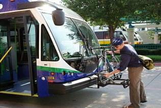
14 Typical sections (DA attachments) Demonstrate compliance with standards Show how the project fits into existing footprint as well as the built and natural environments 14

15 Typical sections (attachments) 1 * Free online tool: streetmix.net *1 minimum required, 2 recommended 15
16 Maps What do maps convey? Need and purpose Context Connectivity Accessibility Safety Communities/areas served What should be included? Project limits and location Schools, transit, major destinations Important community landmarks and features Identified safety hazards Proposed countermeasures Elements of project complexity (ROW, Utilities, RR x-ing, etc.) Existing and/or planned pedestrian/bicycle routes 16

17 Project location map - REQUIRED Identifies: Street names Transit stops Existing bike/ped network Parks Public housing Government facilities Retail establishments Identified safety concerns Location of proposed improvements 17

18 Project layout - REQUIRED Identifies: Bicycle and pedestrian accommodations Safety features Interactions between auto and non-motorized traffic Transit connections Preserved landscape features Includes: Scale Context Street names 18

19 Example: Regional/Local Connectivity Regional/Local Connectivity Map(s) can: Identify connections to proposed Texas Bicycle Tourism Trails Nearby bicycle or pedestrian existing/planned infrastructure 19

20 Project is on Texas Bicycle Tourism Trails Example Network Project End Project Begin 20

21 Maps can be made easily! Google Earth, Google maps, Powerpoint, and other FREE online map creation software Sample map made in Google Earth Safety Issue #1: uncontrolled crossing of high speed roadway from neighborhood to school 21
22 Photographs What do photographs convey? Context, including built and natural environment Existing conditions Need for project Safety hazards Accessibility issues Environmental considerations 22


23 Photographs provide context Historic districts Environmental features Separated vs onstreet pathways Repurposed bridges Adjacent historic buildings along SH 29 facing west (7/19/16) Historic truss bridge repurposed for bike/ped use on SH 150 facing south (5/14/16) 23


24 Photographs demonstrate existing conditions 1. Poor conditions 2. Absent facilities 3. Worn paths


25 Photographs identify locations of unsafe conditions Safety hazards identified Kids walking in streets Unsignalized crossings 25
 Photograph labels should identify: location, direction of photograph, date")
26 Photography: Best Practices Group well-labeled photographs together for attachments (ie. using Word, PowerPoint, or Publisher) Photograph labels should identify: location, direction of photograph, date taken, and items of note. 26
27 Public and stakeholder support What does public/stakeholder support convey? Community awareness and interest in the project Partnerships and coordination Transparency Consistency with local planning How is public and stakeholder support documented? Local bicycle, pedestrian, safe routes to school, or other transportation plan (attach relevant pages) Public outreach documentation Local match commitment (Project Sponsor resolution) Collaborative implementation Property ownership and acquisition information Letter of support from education stakeholders TxDOT District letter of concurrence 27

28 Project in Safe Routes to School Plan Delwood Project End Project Begin 28

29 Project identified in regional plan 29


30 Project type/location shown in local/regional plan Project listed in regional transit plan 30


31 Local Support: Best Practice - Public involvement summary 31
 Committing to enter into an Advance Funding Agreement with TxDOT if selected for funding Plan")
32 Project Sponsor Resolution All Detailed Applications must include a resolution from the governing board Declaring support for the project Committing to develop, implement, construct, maintain, manage, and finance the project Committing to provide the local match (if any) Committing to enter into an Advance Funding Agreement with TxDOT if selected for funding Plan ahead! 32
33 TxDOT letter of consent for projects on/along TxDOT roads 33
34 Supporting Activities to Improve Project Success Performance Measurement Encouragement Programs Safety education Student transportation tally Parent survey Bicycle/pedestrian counts Walking school bus/bike train Walk/Bike to School/Work Days Walk to School Wednesdays Bike roadeo These complementary activities are self-funded. 34

35 Proposed budget What does the itemized budget convey? Project scope and scale Prevention of potential overruns Supports activities described elsewhere in detailed application form Project readiness and local support Where does the project sponsor provide the itemized budget? Itemized Construction Cost Estimate (fill-in) Additional Construction-Related Costs (fill-in) 35

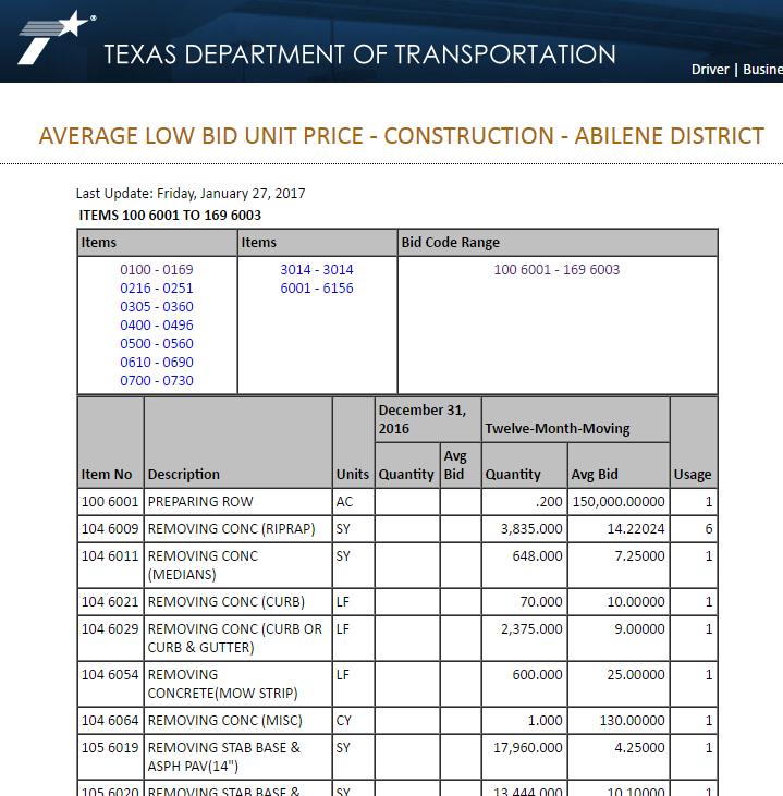
36 Average low bid unit prices 36
37 Budget considerations Small quantities may have higher unit costs Inflation to year of construction Quality construction (e.g., 6-in concrete reinforced with rebar) Adequate dimensions (6-ft sidewalks, 12-ft shared use paths) 37
38 Budget items to remember Mobilization Site preparation Erosion control/revegetation Lighting Curb/driveway work Traffic control Demolition Remediation of hazardous conditions Remember: Federal TA/SRTS funds are fixed based on the estimate in the Detailed Application! 38
39 Examples of eligible vs ineligible activities Eligible activities Incidental landscaping, environmental mitigation, utility adjustments Land survey for ROW demarcation Construction engineering and inspection Project administration Ineligible activities Major landscaping, environmental mitigation, utility adjustments Survey for design (TA only) ROW activities Legal services 39

40 Proposed safety countermeasures included in Itemized Budget 40
41 Project readiness What does project readiness convey? TA projects must let for construction within 3 years! Readiness is important. Awareness of potential pitfalls, challenges, and delays Consideration of all phases of project development Understanding of TxDOT s project development processes How does the project sponsor demonstrate project readiness? Project Details MPO TIP Inclusion Letter (as attachment) Environmental Documentation, if available (as attachment) Property Ownership and Acquisition Information, if necess. (as attachment) Railroad Support/Right-of-Entry, if necessary (as attachment) Project Timeline (fill-in and as attachment) Itemized Construction Cost Estimate (fill-in) 41
42 Advanced coordination may be necessary Railroad agreements Resource agency coordination Environmental permits ROW acquisitions Utility relocations 42
43 Environmental documentation for categorical exclusions Maps and diagrams TxDOT environmental scoping tool/process Historical resource review Archeological resources/cemeteries Water resources Hazardous materials Biological evaluation Public involvement Coordinate with your local TxDOT Environmental Coordinator! 43
44 Historical resources Be proactive! Check the Texas Historical Commission atlas: atlas.thc.state.tx.us Search for Historic Resources Toolkit on txdot.gov THC coordination occurs prior to environmental approval Historical properties can affect design and cost Use TxDOT pre-certified professionals Contact your district environmental coordinator to learn more! 44
45 Summary Provide good project details Use maps, diagrams, and photos that tell a story Demonstrate good public awareness and support Include a thorough, comprehensive budget Plan ahead and coordinate early Focus on the evaluation criteria 45
 486-5972 Noah Heath TxDOT Public Transportation Division Bicycle/Pedestrian")
46 Questions? Bonnie Sherman TxDOT Public Transportation Division Bicycle/Pedestrian Program Manager TA Set-Aside Program Manager (512) Noah Heath TxDOT Public Transportation Division Bicycle/Pedestrian Program Planner (512) Carl Seifert Jacobs Engineering Transportation Planner (512)
47 Online map requirement Need: Exact project locations. Solution: Create digital map, which TxDOT can import easily. Create Google account (if necessary) Set-up map Create Map Name Choose Map Base Add project start and end points OPTIONAL: Draw proposed project route (line) Draw any other elements Share Map Click share make public on web Copy map link Paste map link into PA and DA Instructions for creating simple Google map 47

 Select base map Click triangle next to Base map")
48 Online map requirement walk-through (slide 1) Create map name Click Untitled Map and type preferred name in the pop-up. Name should include Project sponsor and name (e.g. SanAngelo_GreenSt_SUP) Select base map Click triangle next to Base map on left side and select a background 48
")


49 Online map requirement walk-through (slide 2) Navigate to your project area Click in search area Type location name or street name Add starting and ending points Click Add marker Place markers on the map Label markers Start and End Click save 49

50 Online map requirement walk-through (slide 3) Share map Click Share Click Change Select On Public on the web Click save. Copy Link to share and paste into PA and eventually DA 50
BEST PRACTICES FOR PROJECT NOMINATIONS TA Set-Aside Program
 BEST PRACTICES FOR PROJECT NOMINATIONS 2017 TA Set-Aside Program Focus of this presentation Photos Public Support Maps & Exhibits Proposed Budget Design Details Project Evaluation & Selection Criteria
FDOT D4 Complete Streets
 FDOT D4 Complete Streets Context Sensitive Solutions Directs that complete street solutions will complement the context of the community. Collaborative approach to decision making, project development,
Clay Street Bridge Replacement Project
 Clay Street Bridge Replacement Project Frequently Asked Questions (FAQs) No. 2 April 4, 2018 The project is located in downtown Placerville on Clay Street between US Highway 50 and Main Street and Cedar
INTRODUCTION EXISTING CONDITIONS
 INTRODUCTION The Pedestrian Mobility Study and Plan is a Transportation Planning effort to identify Safe Mobility Alternatives for Pedestrian and Bicycle traffic within the City of Port Aransas. This plan
This page left intentionally blank.
 July 2012 This page left intentionally blank. Table of Contents Appendix A : Project Development Checklist Appendix B: At-Grade Rail Crossings Appendix C: Maintenance and Operations Examples Appendix D:
WELCOME! 8 8:30 6: TH STREET IMPROVEMENTS. Open House. Presentation & Q&A
 WELCOME! 168 TH STREET IMPROVEMENTS 6:30 Open House 7 8 Presentation & Q&A 8 8:30 Open House WELCOME Todd Pfitzer City of Omaha Engineer Bob Stubbe City of Omaha Public Works Director Jon Meyer Project
SH 199 Corridor Master Plan. Community Meeting No. 2 May 31, 2017
 Community Meeting No. 2 May 31, 2017 Transportation Projects On or Near SH 199 SH 199 from 0.3 miles south of FM 1886 to south end of Lake Worth bridge Construct freeway mainlanes and frontage roads 10-Year
City of Hermosa Beach Administrative Policy #
 City of Hermosa Beach Administrative Policy # SUBJECT: Living Streets Policy Date: Approved by: City Council Authority: Public Works Department & Community Development Department Mayor, PURPOSE The City
People who are members of historically disenfranchised racial, ethnic, cultural, and other identity groups are encouraged to apply.
 CALL TO ARTISTS REQUEST FOR QUALIFICATIONS CITY OF TACOMA MUNICIPAL ART PROGRAM East 64 th Streetscape, Tacoma, WA APPLICATION DEADLINE October 10, 2018, 11:59pm BUDGET $72,000, all-inclusive SUMMARY The
CITY OF CHARLOTTESVILLE, VIRGINIA CITY COUNCIL AGENDA
 CITY OF CHARLOTTESVILLE, VIRGINIA CITY COUNCIL AGENDA Agenda Date: December 16, 2013 Action Required: Adoption of Resolution Presenter: Staff Contacts: Title: James E. Tolbert, AICP, Director of NDS James
Scope of Services. River Oaks Boulevard (SH 183) Corridor Master Plan
 Corridor Master Plan") Scope of Services River Oaks Boulevard (SH 183) Corridor Master Plan PROJECT AREA The project area consists of the River Oaks Boulevard (SH 183) corridor bounded by SH 199 at the northern end and the Trinity
Scope of Services River Oaks Boulevard (SH 183) Corridor Master Plan PROJECT AREA The project area consists of the River Oaks Boulevard (SH 183) corridor bounded by SH 199 at the northern end and the Trinity
July 12, Columbus City Council City Hall 90 West Broad Street Columbus, OH RE: I-70/71 Columbus Crossroads Project
 OHIO DEPARTMENT OF TRANSPORTATION DISTRICT 6 400 EAST WILLIAM STREET DELAWARE, OHIO 43015 800.372.7714 Columbus City Council City Hall 90 West Broad Street Columbus, OH 43215-9015 RE: I-70/71 Columbus
The Illinois Department of Transportation and Lake County Division of Transportation. Route 173, including the Millburn Bypass
 The Illinois Department of Transportation and Lake County Division of Transportation welcome you to this Public Hearing for U.S. Route 45 from Illinois Route 132 to Illinois Route 173, including the Millburn
The transportation system in a community is an
 7 TRANSPORTATION The transportation system in a community is an important factor contributing to the quality of life of the residents. Without a sound transportation system to bring both goods and patrons
Transportation Land Use Integration & Regional Planning. Don Kostelec, AICP Senior Planner, Louis Berger Group February 1, 2010
 Transportation Land Use Integration & Regional Planning Don Kostelec, AICP Senior Planner, Louis Berger Group February 1, 2010 Transportation Land Use Integration DOT-HUD-EPA Sustainable Communities Initiative
SAN RAFAEL GENERAL PLAN 2040 INTRODUCTION AND OVERVIEW
 SAN RAFAEL GENERAL PLAN 2040 INTRODUCTION AND OVERVIEW Steering Committee Presentation February 14, 2018 Purpose of General Plan Guide land use and development decisions Coordinate transportation, infrastructure,
Public input has been an important part of the plan development process.
 Lakewood s Comprehensive Plan recognizes that transportation helps shape the community, and that the way the community provides for the safe and efficient movement of people affects the character of the
Route 1 Corridor Study
 Route 1 Corridor Study Westbrook, Connecticut A Vision for the Connecticut Shoreline Public Informational Meeting July 28, 2015 Lower Connecticut River Valley Council of Governments Fitzgerald & Halliday,
STATE OF TENNESSEE DEPARTMENT OF TRANSPORTATION ENVIRONMENTAL DIVISION
 STATE OF TENNESSEE DEPARTMENT OF TRANSPORTATION ENVIRONMENTAL DIVISION Suite 900 - James K. Polk Building 505 Deaderick Street Nashville, Tennessee 37243-0334 MEMORANDUM TO: FROM: Files Joe W. Matlock,
Atlanta BeltLine Subarea 3 Master Plan Update
 Atlanta BeltLine Subarea 3 Master Plan Update April 14, 2018 Workshop Meeting 1 22 miles, connecting 45 neighborhoods 22 MILES of transit 46 MILES of streetscapes and complete streets 33 MILES of urban
EXHIBIT A. Tax Increment Reinvestment Zone No. 1 (Town Center) First Amended Project Plan 1
 First Amended Project Plan 1") EXHIBIT A Tax Increment Reinvestment Zone No. 1 (Town Center) First Amended Project Plan 1 1 As amended by Resolution No. 2008-02-001(TR1R) of the Tax Increment Reinvestment Zone No.1, and approved to
EXHIBIT A Tax Increment Reinvestment Zone No. 1 (Town Center) First Amended Project Plan 1 1 As amended by Resolution No. 2008-02-001(TR1R) of the Tax Increment Reinvestment Zone No.1, and approved to
Transportation Alternatives Program (TAP) Experience
 Experience") 1 Transportation Alternatives Program (TAP) Experience McCormick Taylor is a full-service engineering firm providing creative design, planning, and environmental solutions to the challenges of everyday
1 Transportation Alternatives Program (TAP) Experience McCormick Taylor is a full-service engineering firm providing creative design, planning, and environmental solutions to the challenges of everyday
Summary of Action Strategies
 Strategic Action Plan 6 Summary of Action Strategies Action Strategy Categories: 1. Organization and Management 2. Implementation 3. Marketing and Promotion This chapter summarizes all of the action strategies
To qualify for federal Transportation Enhancement (TE) funds a project must meet two basic federal requirements:
 funds a project must meet two basic federal requirements:") Eligibility Requirements To qualify for federal Transportation Enhancement (TE) funds a project must meet two basic federal requirements: 1) Relate to surface transportation and 2) Be one of the 12 designated
Eligibility Requirements To qualify for federal Transportation Enhancement (TE) funds a project must meet two basic federal requirements: 1) Relate to surface transportation and 2) Be one of the 12 designated
Abingdon Urban Path System
 Abingdon Urban Path System Transportation Enhancement Program Application (FY 2012-2013) Submitted by: Town of Abingdon,Virginia P. O. Box 789 133 West Main Street Abingdon, VA, 24212 November 1, 2011
TRANSPORTATION ELEMENT GOALS, OBJECTIVES, AND POLICIES
 TRANSPORTATION ELEMENT GOALS, OBJECTIVES, AND POLICIES GOAL 2 The City shall provide a safe, convenient, effective, and energy efficient multimodal transportation system which is coordinated with the Future
AGENDA ACTION ITEMS INFORMATION ITEMS
 NOACA Bicycle and Pedestrian Advisory Council Meeting Friday, March 21 st, 2014 10:30 a.m. NOACA Office 1299 Superior Avenue Cleveland, Ohio 44114 Phone: (216) 241-2414; website: www.noaca.org AGENDA ACTION
3. VISION AND GOALS. Vision Statement. Goals, Objectives and Policies
 Vision Statement Queen Creek s interconnected network of parks, trails, open spaces and recreation opportunities provide safe and diverse activities and programs that sustain its unique, small town, equestrian
PARKLET PROPOSAL PACKAGE & PROCESS
 500.3 I PARKLETS The term parklet refers to a small temporary constructed seating or community gathering area over an on-street parking space or an extension of the sidewalk into the operating State highway
State Highway 121 Southwest Parkway. Fort Worth s Transportation Success Story in Design and Cooperation
 State Highway 121 Southwest Parkway Fort Worth s Transportation Success Story in Design and Cooperation Greater Fort Worth Association of Realtors October 24, 2007 Presented by: Dan Lamers, P.E. North
Proposed Comprehensive Plan Strategies DRAFT for discussion June 28, 2017
 Proposed Comprehensive Plan Strategies DRAFT for discussion June 28, 2017 Land Use Rural Areas Refine the Farm and Forest area (FF) Update FF boundaries to account for existing lots less than five acres
The Lincoln Neighborhood Corridor Plan. The LiNC
 October 1, 2014 Planning Commission Study Session The Lincoln Neighborhood Corridor Plan The LiNC Purpose of Tonight s Meeting Introduction to The LiNC Review of Existing Conditions and Community Identified
Tonight s Agenda. Summary Presentation Open House. Group Discussion Next Steps: online community wide survey
 Community Open House February 22, 2018 Tonight s Agenda Summary Presentation Open House Station 1: Project Overview and Community Input Station 2: Draft Vision and Guiding Principles Station 3: Western,
1.0 INTRODUCTION 1.1 TH 14 WEST STUDY AREA Project Description Functional Classification Purpose of the Project
 1.0 INTRODUCTION 1.1 TH 14 WEST STUDY AREA 1.1.1 Project Description The Trunk Highway (TH) 14 West Corridor is a two-lane roadway approximately 22 miles in length. Located in Nicollet County, the corridor
Enhance the High Line Canal Projects
 Enhance the High Line Canal Projects Joint Project Proposal for Arapahoe County Open Spaces Funding Partner Sponsors: South Suburban Park and Recreation District City of Centennial City of Littleton October
PLAN ELEMENTS WORKSHOP. April 5, 2016
 PLAN ELEMENTS WORKSHOP April 5, 2016 needs more housing. But there is no one-size fits-all solution. Every neighborhood has its own character. In some places, density is not only appropriate it is badly
2017 General Obligation Bond
 2017 General Obligation Bond Presentation of Public and Council Projects to the Transportation & Mobility Stakeholder Committee April 13, 2017 Agenda Deferred Maintenance Project Development Process Projects
The University District envisions, in its neighborhood
 Envisioning the University District Link Light Rail in Seattle s neighborhoods CIY OF SEALE CONCEP-LEVEL SAION AREA PLANNING RECOMMENDAION RESOLUION # 30165 EXHIBI L Vision 08.2000 he University District
Atlanta BeltLine Corridor Environmental Study. Scoping Meeting August 2008
 Atlanta BeltLine Corridor Environmental Study Scoping Meeting August 2008 What Will We Be Discussing Today? Study Overview - How Did We Get Here? - What Is the Study About? - Who Is Involved? - Where Is
HILLSBOROUGH COUNTY Greenways and Trails Plan Update. Executive Summary. Date
 HILLSBOROUGH COUNTY Greenways and Trails Plan Update Executive Summary Date PURPOSE AND PROJECT OVERVIEW The Hillsborough County Greenways Master Plan (1995) and the City of Tampa s Greenways and Trails
Executive Summary. NY 7 / NY 2 Corridor
 Executive Summary NY 7 / NY 2 Corridor Transportation and Land Use Study December 2005 Prepared for: Town of Colonie Capital District Transportation Committee Prepared by: Introduction: Land use decisions
Project Overview. Fairfax County Parkway Widening Fairfax County. Get Involved. Public Information Meeting. Contact Information
 Get Involved VDOT representatives will review and evaluate information received as a result of this meeting. Please fill out the comment sheet provided in this brochure if you have any comments or questions.
ITS Concept Development Activity Descriptions
 ITS Concept Development Activity Descriptions October 2015 Procedures are subject to change without notice. Check the NJDOT website to ensure this is the current version. Table of Contents Concept Development
Pennsy Greenway Trail
 Town of Schererville Pennsy Greenway Trail DES. #s: 0401062, 1173595 & 1382661 Construction of Pennsy Greenway Trail beginning at Wilhelm Street and continuing northwest along the former Penn Central railroad
Concluding Improvement Recommendations and Opinions of Probable Cost (calculated in may 2010 construction rates).
.") Pelican Bay Community Improvement Plan Traffic,JI Concluding Improvement Recommendations and Opinions of Probable Cost (calculated in may 2010 construction rates). D1 -A: Provide consistent signing, marking
Pelican Bay Community Improvement Plan Traffic,JI Concluding Improvement Recommendations and Opinions of Probable Cost (calculated in may 2010 construction rates). D1 -A: Provide consistent signing, marking
LOCATION AND DESIGN DIVISION
 VIRGINIA DEPARTMENT OF TRANSPORTATION LOCATION AND DESIGN DIVISION INSTRUCTIONAL AND INFORMATIONAL MEMORANDUM GENERAL SUBJECT: Landscape Architecture Program NUMBER: SPECIFIC SUBJECT: Integration of Landscape
Introduction. Chapter 1. Purpose of the Comprehensive Plan Plan Organization Planning Process & Community Input 1-1
 Chapter 1 Introduction Lakewood 2025: Moving Forward Together Purpose of the Comprehensive Plan Plan Organization Planning Process & Community Input 1-1 Purpose of the Comprehensive Plan The Comprehensive
SPRINGHILL LAKE TRANSIT VILLAGE
 Greenbelt Metro Area Sector Plan - Subarea Design Policies and Guidelines - Springhill Lake Transit Village 113 SPRINGHILL LAKE TRANSIT VILLAGE Residential Neighborhood and Village Center CONCEPT Springhill
master plan of highways bus rapid transit amendment
 Scope of Work master plan of highways bus rapid transit amendment September 2011 Montgomery County Planning Department M-NCPPC MontgomeryPlanning.org 1 Scope of Work master plan of highways bus rapid transit
SECTION 4(f) DE MINIMIS DOCUMENTATION
 DE MINIMIS DOCUMENTATION") SECTION 4(f) DE MINIMIS DOCUMENTATION Illinois Route 60/83 IL 176 to the intersection of IL 60 (Townline Road) Lake County P-91-084-07 Mundelein Park and Recreation District Project Limit SECTION 4(f)
SECTION 4(f) DE MINIMIS DOCUMENTATION Illinois Route 60/83 IL 176 to the intersection of IL 60 (Townline Road) Lake County P-91-084-07 Mundelein Park and Recreation District Project Limit SECTION 4(f)
Corridor Beautification Partnership
 Corridor Beautification Partnership December 6, 2016 Lindsey Guindi, Director of Strategic Projects Lindsay Hackett, Staff Planner Stephanie Doland, Staff Planner Corridor Beautification Partnership FY
A larger version of this map is located on the last page of this PDF.
 MAP Committee Input McLoughlin Area Draft Vision Map A larger version of this map is located on the last page of this PDF. 1. The map above is intended to portray a vision for the McLoughlin area. It highlights
Project Overview. Get Involved. Public Information Meeting. Contact Information
 Get Involved VDOT representatives will review and evaluate information received as a result of this meeting. Please fill out the comment sheet provided in this brochure if you have any comments or questions.
ESTABLISH AN EFFICIENT TOWN CENTER
 ESTABLISH AN EFFICIENT TOWN CENTER 4 Overview Lisbon residents are proud of the history of Newent and at the same time recognize its current importance as a centralized location for a variety of municipal
BeltLine Corridor Environmental Study
 BeltLine Corridor Environmental Study Joint TAC and SAC Meeting December 8, 2008 What We Will Discuss Today Outreach and Agency Coordination Scoping Results Existing Conditions Historical and Archeological
Onondaga County Sustainable Streets Project. Onondaga County Planning Federation June 7, Onondaga County Sustainable Streets Project 1
 Onondaga County Sustainable Streets Project Onondaga County Planning Federation June 7, 2012 Onondaga County Sustainable Streets Project 1 Sustainable Streets 1. Introduction to the SMTC 2. Sustainable
REGIONAL ACTIVITY CENTER
 DRAFT REGIONAL ACTIVITY CENTER 70 EAST BENCH MASTER PLAN DRAFT 06 Introduction The East Bench Regional Activity center is comprised of large educational, research, medical, and employment centers. These
TRANSPORTATION ELEMENT
 TRANSPORTATION ELEMENT GOAL I: To create and maintain a safe, efficient and aesthetic transportation system that encourages multi-modal transportation and promotes the mobility strategies of the Ocala
I. DESCRIPTION OF PROPOSED ACTION... 1 A. General Description... 1 B. Historical Resume and Project Status... 2 C. Cost Estimates...
 PROJECT COMMITMENTS SUMMARY... S-1 1. Type of Action... S-1 2. Description of Action... S-1 3. Summary of Purpose and Need... S-1 4. Alternatives Considered... S-2 5. NCDOT Alternatives Carried Forward...
PIKE PINE RENAISSANCE: ACT ONE. October 19, 2017
 PIKE PINE RENAISSANCE: ACT ONE October 19, 2017 WATERFRONT SEATTLE PROGRAM PROJECT INTRODUCTION Pike and Pine streets, between First and Melrose avenues Pedestrian and streetscape improvements Budget:
City of Nogales General Plan
 Open Space, Parks, Recreation and Trails City of Nogales General Plan Residents of Nogales place a high priority in the development of a comprehensive system of open space, parks, recreation and trails
Overview of Southwestern Pennsylvania Commission s (SPC) 2040 Long Range Transportation Plan (LRTP)
 2040 Long Range Transportation Plan (LRTP)") Overview of Southwestern Pennsylvania Commission s (SPC) 2040 Long Range Transportation Plan (LRTP) Presented to Pennsylvania Agency Coordination Meeting May 27, 2015 Doug Smith & Ryan Gordon 1 Southwestern
Overview of Southwestern Pennsylvania Commission s (SPC) 2040 Long Range Transportation Plan (LRTP) Presented to Pennsylvania Agency Coordination Meeting May 27, 2015 Doug Smith & Ryan Gordon 1 Southwestern
IDENTIFYING, EVALUATING, AND PRESERVING MINNESOTA'S HISTORIC ROADSIDE FACILITIES
 IDENTIFYING, EVALUATING, AND PRESERVING MINNESOTA'S HISTORIC ROADSIDE FACILITIES Overview Minnesota built many wayside rest areas during 1930s & '40s (New Deal-WPA, CCC) Many are now threatened Limited
Right-of-Way Acquisitions and Relocations Technical Memorandum
 Right-of-Way Acquisitions and Relocations Technical Memorandum Southeast Extension Project Lincoln Station to RidgeGate Parkway Prepared for: Federal Transit Administration Prepared by: Denver Regional
Elgin O Hare Western Access Project Local Advisory Committee. February 10, 2014
 Elgin O Hare Western Access Project Local Advisory Committee February 10, 2014 Agenda Project status update Design and construction Funding Aesthetics Project events and outreach Land acquisition Next
Sustainable Development Call for Projects Western Infrastructure Project Submissions
 2009-2010 Sustainable Development Call for Projects Western Infrastructure Project Submissions January 20, 2010 2009-2010 SDCFP Summary of Infrastructure Funding Infrastructure Projects Number of Projects
DULUTH MINNESOTA GREENSTEP CITY
 DULUTH MINNESOTA GREENSTEP CITY GreenStep Cities Partner organizations A Minnesota Pollution Control Agency and GreenStep Cities Minnesota GreenStep Cities is a voluntary challenge and recognition program
Provide and maintain sufficient public parks, recreation facilities, and open space to meet the recreational needs of County residents and visitors.
 (ROS) Goal Provide and maintain sufficient public parks, recreation facilities, and open space to meet the recreational needs of County residents and visitors. OBJECTIVE ROS.01 The County shall acquire,
CAPA ASPHALT & AIRPORT PAVEMENT MARCH 27, 2019
 CAPA ASPHALT & AIRPORT PAVEMENT MARCH 27, 2019 PRESENTERS William Epp, PE, SE Colorado Division Manager Senior Vice President Brett Holt, PE Project Manager WHO WE ARE A nationally recognized transportation
SDOT DPD. SDOT Director s Rule DPD Director s Rule DCLU DR SED DR of 7 CITY OF SEATTLE
 SDOT SDOT Director s Rule 2-07 DPD Applicant: CITY OF SEATTLE Page 1 of 7 Supersedes: DCLU DR 11-93 SED DR 93-4 Seattle Department of Transportation (SDOT) Department of Planning and Development (DPD)
TENNESSEE STATE ROUTE 109 CORRIDOR MANAGEMENT AGREEMENT MEMORANDUM OF UNDERSTANDING CORRIDOR MANAGEMENT ALONG STATE ROUTE 109
 TENNESSEE STATE ROUTE 109 CORRIDOR MANAGEMENT AGREEMENT MEMORANDUM OF UNDERSTANDING CORRIDOR MANAGEMENT ALONG STATE ROUTE 109 I. Purpose The purpose of this Agreement is to provide a framework for the
CHAPTER 7: Transportation, Mobility and Circulation
 AGLE AREA COMMUNITY Plan CHAPTER 7 CHAPTER 7: Transportation, Mobility and Circulation Transportation, Mobility and Circulation The purpose of the Transportation, Mobility and Circulation Chapter is to
CHAPTER 1. Ms. Guajardo s Class - Central Elementary CH 1 1
 INTRODUCTION CHAPTER 1 Ms. Guajardo s Class - Central Elementary CH 1 1 1.1 SETTING South Centre City is a linear corridor south of Downtown Escondido paralleling Centre City Parkway and South Escondido
Preservation Planning
 Protect and Maintain the Historic Character of your Community Beverly, West Virginia Randolph County HLC PROTECT Purpose of all work done in survey and registration is not to only register properties.
Johnson Street Bridge Public Realm Update
 Johnson Street Bridge Public Realm Update August 20, 2015 Background Johnson Street Bridge Replacement Project impacts a diverse range of stakeholders In addition to a new bridge, the project also includes
Urban Design 9Identity
 Urban Design 9Identity URBAN DESIGN IDENTITY Urban design is about connecting people to their places through the built environment, nature, and overall urban form. Done well, it creates a memorable space
Mississippi Skyway Preliminary Engineering Report
 EXECUTIVE SUMMARY Mississippi Skyway Preliminary Engineering Report CITY OF RAMSEY, MINNESOTA DECEMBER 2014 City of RAMSEY EXECUTIVE SUMMARY Project Need and Intent The Mississippi Skyway pedestrian bridge
Public Information/Cultural Resources Committee Workshop August 15, Florida Department of Transportation District One
 Public Information/Cultural Resources Committee Workshop August 15, 2012 Florida Department of Transportation District One SR 542 from 1 st Street to E. of Buckeye Loop Road Winter Haven, Polk County FPID#
MEMO 1. INTRODUCTION PURPOSE & PROCESS REQUEST
 MEMO Date: August 22, 2017 To: Board of Commissioners From: Jason Burdette, Planning Director Re: Davidson Commons East Hotel Stakeholder Feedback 1. INTRODUCTION PURPOSE & PROCESS This memorandum summarizes
Potential Green Infrastructure Strategies May 6, 2015 Workshop
 Potential Green Infrastructure Strategies May 6, 2015 Workshop Background The City of Cortland is developing the Tioughnioga Urban Headwaters Green Infrastructure Action Plan with funding from the National
PROJECT STATEMENT LOCATION/DESIGN PUBLIC HEARING. 19 th AVENUE NORTH EXTENSION PROJECT FROM SPRINGDALE DRIVE TO NORTH 2 ND STREET/U.S.
 PROJECT STATEMENT LOCATION/DESIGN PUBLIC HEARING 19 th AVENUE NORTH EXTENSION PROJECT FROM SPRINGDALE DRIVE TO NORTH 2 ND STREET/U.S. 67 HEARING LOCATION: ERICKSEN COMMUNITY CENTER 1401 11 TH AVENUE NORTH
Historic Bridge Adoption Information Packet
 Historic Bridge Adoption Information Packet Falls County CR 179 over Big Elm Creek Bridge October 2017 Table of Contents Announcement... 3 Bridge Location... 4 Bridge Information... 4 Bridge Condition
STREETSCAPE MANUAL ONLINE TRAINING SESSION 3: Decision-Making
 TRAINING SESSION 3: The Urban Design Streetscape Manual is a reference tool developed to help implement City policy and guide the design, construction and maintenance of streetscape improvements in Toronto.
ARTICLE 6: Special and Planned Development Districts
 ARTICLE 6: Special and Planned Development Districts 6-10 Traditional Neighborhood Development (TND) District 6-10.10 Purpose and Intent The Traditional Neighborhood Development (TND) District provides
The Auburn Plan Designing the Future of Auburn February 28, 2005
 The Auburn Plan Designing the Future of Auburn February 28, 2005 Block-by-Block Bicycle Tour Aerial survey Focus Group Meetings September 7 and 8 Design Workshops October 11, 14, and 21 Revitalization
Whitemarsh Comprehensive Plan Update: Housing & Land Use. Public Workshop #3: September 20, 2018
 Whitemarsh Comprehensive Plan Update: Housing & Land Use Public Workshop #3: September 20, 2018 Agenda Welcome Process Recap What We ve Heard The Plan Framework Review of Recommended Actions Land Use Housing
CITY OF LARKSPUR Staff Report. August 21, 2013 Council Meeting UPDATE ON TRANSPORTATION AUTHORITY OF MARIN (TAM) GREENBRAE CORRIDOR WORKING GROUP
 GREENBRAE CORRIDOR WORKING GROUP") AGENDA ITEM 7.1 CITY OF LARKSPUR Staff Report August 21, 2013 Council Meeting DATE: August 16, 2013 TO: FROM: SUBJECT: Honorable Mayor Hillmer and Members of the City Council Dan Schwarz, City Manager
AGENDA ITEM 7.1 CITY OF LARKSPUR Staff Report August 21, 2013 Council Meeting DATE: August 16, 2013 TO: FROM: SUBJECT: Honorable Mayor Hillmer and Members of the City Council Dan Schwarz, City Manager
RFP REQUEST FOR PROPOSALS CITY OF PORTSMOUTH, NH. DESIGN ENGINEERING SERVICES North Mill Pond Trail and Greenway
 RFP 61-18 REQUEST FOR PROPOSALS CITY OF PORTSMOUTH, NH DESIGN ENGINEERING SERVICES North Mill Pond Trail and Greenway Sealed Requests for Proposals, plainly marked RFP 61-18 Design Engineering Services
TRANSIT ORIENTED DEVELOPMENT PINELLAS COUNTY MPO LIVABLE COMMUNITIES INITIATIVE PINELLAS COUNTY COMPREHENSIVE PLAN AMENDMENTS
 PINELLAS COUNTY MPO LIVABLE COMMUNITIES INITIATIVE MODEL LAND DEVELOPMENT CODE TRANSIT ORIENTED DEVELOPMENT PINELLAS COUNTY COMPREHENSIVE PLAN AMENDMENTS MPO Livable Communities Initiative Goal: Improve
Seattle s Natural Drainage Systems and Complete Streets
 Seattle s Natural Drainage Systems and Complete Streets NACTO Designing Cities 2016 Outline Set stage Seattle and systems How Seattle has utilized bioretention to protect water systems Pathways for project
planning toronto s downtown Parks and Public Realm Plan Request for Proposals Information Meeting Andrew Farncombe, Project Manager August 19, 2015
 planning toronto s downtown Parks and Public Realm Plan Request for Proposals Information Meeting Andrew Farncombe, Project Manager August 19, 2015 BATHURST ST Keeping Downtown a great place to live, work,
I-70 Corridor Enhancement Plan
 i - Table of Contents Table of Contents Chapter I Overview Chapter II Bridge and Roadway Improvements Chapter III Landscape Enhancements Chapter IV Riparian Corridors Chapter V Showcase Missouri Plan Chapter
The Vision. Photo provided by The Minervini Group. 46 Vision, Objectives & Strategies
 Vision, Objectives & Strategies The is the public framework and guide for future development of the Grand Traverse Commons. The establishes public polices for infrastructure, the preservation of natural
Denver Moves: Transit Task Force
 Insert transit picture Denver Moves: Transit Task Force Meeting #8 October 5, 2017 1. Welcome & Introductions Opening remarks and housekeeping Task Force and audience introductions Upcoming events and
THE POLICY FRAMEWORK FOR WALKABLE COMMUNITIES. Community Technical Assistance Program Building Active Communities Institute March 2016
 THE POLICY FRAMEWORK FOR WALKABLE COMMUNITIES Community Technical Assistance Program Building Active Communities Institute March 2016 ACTIVE COMMUNITIES BACK THEN ACTIVE COMMUNITIES BACK THEN Lifestyle
RIVER ARTS DISTRICT TRANSPORTATION PROJECT
 RIVER ARTS DISTRICT TRANSPORTATION PROJECT A section of the Public Meeting #3 December 6, 2012 The RiverWay Plan The Wilma Dykeman RiverWay is a 17 mile corridor along the French Broad and Swannanoa Rivers.
REQUEST FOR QUALIFICATIONS
 REQUEST FOR QUALIFICATIONS VILLAGE OF HAMBURG COMPREHENSIVE ZONING/LAND USE REGULATIONS UPDATE Prepared By: Village of Hamburg 100 Main Street Hamburg, New York 14075 Village of Hamburg RFQ Page 1 of 10
Ashland BRT Environmental Assessment: logos of CTA, CDOT, Chicago Department of Housing and Economic Development
 Ashland BRT Environmental Assessment: logos of CTA, CDOT, Chicago Department of Housing and Economic Development Overview The Chicago Transit Authority (CTA), in partnership with the Chicago Department
Longmeadow Parkway Fox River Bridge Corridor. August 6, 2015
 Longmeadow Parkway Fox River Bridge Corridor August 6, 2015 Longmeadow Parkway Bridge Corridor 5.6 miles from Huntley Road to IL 62 Unique municipal/county/state/federal partnership Links Randall Road
Open House RIVER DES PERES GREENWAY: LANSDOWNE SHREWSBURY METROLINK TO FRANCIS R. SLAY PARK
 Open House 10.12.16 RIVER DES PERES GREENWAY: LANSDOWNE SHREWSBURY METROLINK TO FRANCIS R. SLAY PARK MEETING AGENDA Great Rivers Greenway and Project Partners River des Peres Greenway Overview Project