Update on Anticipated Pipeline Alignment within Proposed Route for the Black Dog Natural Gas Pipeline Project Docket No.
|
|
|
- Hector Pope
- 6 years ago
- Views:
Transcription

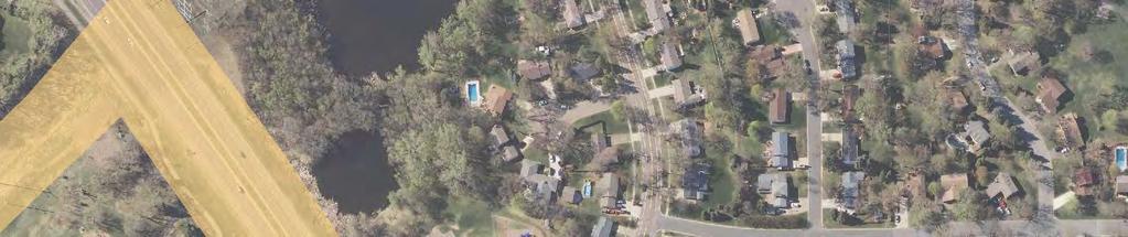
1 414 Nicollet Mall Minneaolis, MN October 26, 2016 Daniel P. Wolf Executive Secretary Minnesota Public Utilities Commission th Place East, Suite 350 St. Paul, MN Via Electronic Filing RE: Udate on Anticiated Pieline Alignment within Proosed Route for the Black Dog Natural Gas Pieline Project Docket No. G002/GP Dear Mr. Wolf: On August 18, 2016 Northern States Power Comany, a Minnesota cororation, doing business as Xcel Energy, submitted an Alication for a Route Permit for the Black Dog Natural Gas Pieline Project (Project) ursuant to Minnesota Rules Chater The urose of this letter is to rovide an udate on the anticiated ieline alignment. As described in the alication the roosed route was designed to minimize imacts to rivate roerties by lacing the ieline rimarily within road right-of-way and on land owned by the and Northern States Power. The route width was designed to allow for minor changes in the anticiated alignment based on detailed engineering and survey results for existing infrastructure. Since the time the alication was submitted Project engineers have refined the anticiated alignment based on survey data and more detailed engineering. There are no changes roosed to the route width. A ma of the reliminary and udated alignments is enclosed. The first roosed change in alignment is at the location where the ieline leaves Old Sibley Memorial Highway and crosses under Highway 13. The alignment in this location has been straightened somewhat because the more erendicular highway crossing shown in the reliminary alignment would have resulted in horizontal and vertical angles for drilling and installing ie that were difficult to achieve based on the terrain in that location. The Project team is coordinating with MN Deartment of Transortation staff on the roosed change. This alignment shift is entirely located within road right-of-way. The second roosed change in the alignment is in the segment where the ieline arallels the electric transmission line corridor on ark arcels. The alication showed and described the alignment in this segment as running generally down the center of the arcels, with the recise location to be determined once more is known about other infrastructure in the corridor. Based on udated information about the location of the storm sewer within this segment the anticiated alignment has been shifted closer to the southwest side of the corridor
2 rather than running down the center. This roosed shift remains within the roosed route width, and is still located on owned land. We have udated the figures which were included in the route ermit alication to show the roosed alignment adjustment. The figures are included with this submittal. The roosed adjustments resulted in aroximately a 5 foot reduction in overall ieline length. Please contact me at ellen.l.heine@xcelenergy.com or if you have questions or would like further information regarding this matter. Sincerely, Ellen Heine Sr. Land Agent Xcel Energy 2

3 Udate to Anticiated Alignment for the Black Dog Natural Gas Pieline Project Udated Anticiated Alignment Preliminary Anticiated Alignment Proosed Route Black Dog Plant NNG Cedar Station Miles October 2016

 B Sec. 24 T27 R23W Sec.")


4 T27 R23W Sec. 18 Canada Sec. 14 Bloomington Sec. 13 Sec. 13 ND T27 R23W Sec. 18 SD Minnesota IA T27 MI R23W Sec. 17 WI Sec. 24 Sec. 23 ") B Sec. 24 T27 R23W Sec. 19 T27 R23W Sec. 20 Sec. 23 Sec. 26 Sec ,000 2,000 1 inch = 2,000 feet For Environmental Review Puroses Only Data Sources: Xcel, MN DOT, USGS Data Source: Sec. 36 Sec. 25 Figure 1 Toograhic Ma Gas Pieline Project T27 R23W Sec. 30 T27 R23W Sec. 31 Proosed Pieline Alignment T27 R23W Sec. 29 T27 R23W Sec. 32 Date: (10/24/2016) Source: Z:\Clients\U_X\Xcel\Black_Dog_Gas_Pieline\Permitting\PUC_Route_Permit\Figures\Figure_1_Black_Dog_Route_Too_Ma.mxd


5 rraleighd Long Meadow Lake Hennein Black Dog Rd Minnesota River ") B Sibley Ct Frontage Rd S Territorial Dr 19th Ave Woods La 117th St E ,200 1 inch = 1,200 feet For Environmental Review Puroses Only Sioux Ct WRiver Hills Dr Data Sources: Xcel, MN DOT, & MNDNR Tamarack La Imagery Sources: Twin Cities Metro, 2013 RadissonDr SchoolcraftRd Zebulon Pike Ave 115th St E Sibley Dr 22nd Ave Hayes 114th St E 23rd Ave Hayes Dr Ct CarverCt Exlorer Ct London Ct M-964 Dr Horizon London Dr 27th Ave Valley Ct Cambridge C Clifton Ave t Keating Ct Keating Ave MccleodSt Figure 2 Aerial Ma Gas Pieline Project Foxoint Rd N River Hills Dr ChandlerCt r Pioneer D Cedarbridge Ave Southview Dr Ravoux Ave GaltierDr Perrot La 112th St E Lewis Ct Lake Ct Medary Dr Clark St Metcalf Dr Slater Rd OldSibley Hwy ") 30 Cinnamon Ridge Tr «77 Erin Dr Proosed Pieline Alignment Date: (10/24/2016) Source: Z:\Clients\U_X\Xcel\Black_Dog_Gas_Pieline\Permitting\PUC_Route_Permit\Figures\Figure_2_Black_Dog_Route_Aerial_Ma.mxd
6 rraleighd Long Meadow Lake Hennein Black Dog Rd Minnesota River ") B Sibley Ct Frontage Rd S Territorial Dr 19th Ave Woods La 117th St E ,200 1 inch = 1,200 feet For Environmental Review Puroses Only Sioux Ct WRiver Hills Dr Data Sources: Xcel, MN DOT, & MNDNR Tamarack La Imagery Sources: Twin Cities Metro, 2013 RadissonDr SchoolcraftRd Zebulon Pike Ave 115th St E Sibley Dr 22nd Ave Hayes 114th St E 23rd Ave Hayes Dr Ct CarverCt Exlorer Ct London Ct M-964 Dr Horizon London Dr 27th Ave Valley Ct Cambridge C Clifton Ave t Keating Ct Keating Ave MccleodSt Figure 3 Evaluated Routes Gas Pieline Project Foxoint Rd N River Hills Dr ChandlerCt r Pioneer D Cedarbridge Ave Southview Dr Ravoux Ave GaltierDr Perrot La 112th St E Lewis Ct Lake Ct Medary Dr Clark St Metcalf Dr Slater Rd OldSibley Hwy ") 30 Cinnamon Ridge Tr «77 Erin Dr Proosed Pieline Route Proosed Pieline Alignment Other Evaluated Alignment Existing Electric Transmission Line Existing Gas Pieline Date: (10/24/2016) Source: Z:\Clients\U_X\Xcel\Black_Dog_Gas_Pieline\Permitting\PUC_Route_Permit\Figures\Figure_3_Black_Dog_Route_Evaluated_Route.mxd


")

7 Sibley Ct inch = 300 feet For Environmental Review Puroses Only Data Sources: Xcel, MN DOT, & MNDNR Imagery Sources: Twin Cities Metro, 2013 Old Sibley Hwy Figure 4.1 Proosed Route Gas Pieline Project «77 Proosed Pieline Alignment Proosed Pieline Route Parcel Boundary Date: (10/24/2016) Source: Z:\Clients\U_X\Xcel\Black_Dog_Gas_Pieline\Permitting\PUC_Route_Permit\Figures\Figure_4_Series_Black_Dog_Proosed_Route.mxd
30 Pioneer Dr Ridgewood Ct Southview Dr WRiver Hills Dr")


8 Foxoint Cir Old Sibley Hwy Ce darbridgeave Foxoint Rd ")30 Pioneer Dr Ridgewood Ct Southview Dr WRiver Hills Dr inch = 300 feet For Environmental Review Puroses Only Data Sources: Xcel, MN DOT, & MNDNR Imagery Sources: Twin Cities Metro, 2013 N River Hills Dr Lake Ct Figure 4.2 Proosed Route Gas Pieline Project 112th St E Lewis Ct Metcalf Dr Medary Dr Proosed Pieline Alignment Proosed Pieline Route Parcel Boundary Date: (10/24/2016) Source: Z:\Clients\U_X\Xcel\Black_Dog_Gas_Pieline\Permitting\PUC_Route_Permit\Figures\Figure_4_Series_Black_Dog_Proosed_Route.mxd


9 H ayes Ct Hayes Dr Chatham Ct S London Dr London Ct Radisson Dr Carver Ct 27th Ave 27th Pl Rid gew ood Ct Radisson Ct Scout Cir inch = 300 feet For Environmental Review Puroses Only Exlorer Ct Data Sources: Xcel, MN DOT, & MNDNR Imagery Sources: Twin Cities Metro, th St E Valley Ct Figure 4.3 Proosed Route Gas Pieline Project W River Hills Dr Galtier Dr Galtier Pl Proosed Pieline Alignment Proosed Pieline Route Parcel Boundary Date: (10/24/2016) Source: Z:\Clients\U_X\Xcel\Black_Dog_Gas_Pieline\Permitting\PUC_Route_Permit\Figures\Figure_4_Series_Black_Dog_Proosed_Route.mxd


 Source:")
10 Black Dog Rd ") B inch = 300 feet For Environmental Review Puroses Only Data Sources: Xcel, MN DOT, & MNDNR Imagery Sources: Twin Cities Metro, 2013 Figure 4.4 Proosed Route Gas Pieline Project River Ct Territorial Dr Radisson Dr Hayes Ct Proosed Pieline Alignment Proosed Pieline Route Parcel Boundary Date: (10/24/2016) Source: Z:\Clients\U_X\Xcel\Black_Dog_Gas_Pieline\Permitting\PUC_Route_Permit\Figures\Figure_4_Series_Black_Dog_Proosed_Route.mxd
11 rraleighd Long Meadow Lake Hennein Black Dog Rd Minnesota River ") B Sibley Ct Frontage Rd S Territorial Dr 19th Ave Woods La 117th St E ,200 1 inch = 1,200 feet For Environmental Review Puroses Only Sioux Ct WRiver Hills Dr Data Sources: Xcel, MN DOT, & MNDNR Tamarack La Imagery Sources: Twin Cities Metro, 2013 RadissonDr SchoolcraftRd Zebulon Pike Ave 115th St E Sibley Dr 22nd Ave Hayes 114th St E 23rd Ave Hayes Dr Ct CarverCt Exlorer Ct London Ct M-964 Dr Horizon London Dr 27th Ave Valley Ct Cambridge C Clifton Ave t Keating Ct Keating Ave MccleodSt Foxoint Rd N River Hills Dr Figure 5 Construction Methods Gas Pieline Project ChandlerCt r Pioneer D Cedarbridge Ave Southview Dr Ravoux Ave GaltierDr Perrot La 112th St E Lewis Ct Lake Ct Medary Dr Clark St Metcalf Dr Slater Rd OldSibley Hwy ") 30 Cinnamon Ridge Tr «77 Erin Dr Proosed Pieline Alignment Directional Drill Trench Date: (10/24/2016) Source: Z:\Clients\U_X\Xcel\Black_Dog_Gas_Pieline\Permitting\PUC_Route_Permit\Figures\Figure_5_Black_Dog_Route_Construction_Methods.mxd


 30 Cinnamon Ridge Tr «77 Erin Dr Proosed Pieline Alignment")

12 rraleighd Long Meadow Lake Hennein Black Dog Rd Minnesota River ") B Sibley Ct Frontage Rd S Territorial Dr 19th Ave Woods La 117th St E ,200 1 inch = 1,200 feet For Environmental Review Puroses Only Sioux Ct WRiver Hills Dr Data Sources: Xcel, MN DOT, & MNDNR Tamarack La Imagery Sources: Twin Cities Metro, 2013 RadissonDr SchoolcraftRd Zebulon Pike Ave 115th St E Sibley Dr 22nd Ave Hayes 114th St E 23rd Ave Hayes Dr Ct CarverCt Exlorer Ct London Ct M-964 Dr Horizon London Dr 27th Ave Valley Ct Cambridge C Clifton Ave t Keating Ct Keating Ave MccleodSt Foxoint Rd N River Hills Dr ChandlerCt r Pioneer D Cedarbridge Ave Southview Dr Ravoux Ave Figure 6 Proosed Pieline Alignment Land Ownershi Gas Pieline Project GaltierDr Perrot La 112th St E Lewis Ct Lake Ct Medary Dr Clark St Metcalf Dr Slater Rd OldSibley Hwy ") 30 Cinnamon Ridge Tr «77 Erin Dr Proosed Pieline Alignment Proosed Pieline Route Land Ownershi City Owned Private Road Right-of-Way Parcel Boundary Date: (10/24/2016) Source: Z:\Clients\U_X\Xcel\Black_Dog_Gas_Pieline\Permitting\PUC_Route_Permit\Figures\Figure_6_Black_Dog_Route_Proosed_Alignment_Land_Ownershi.mxd


")

13 Hennein ") B ,200 1 inch = 1,200 feet For Environmental Review Puroses Only Data Sources: Xcel, MN DOT, & MNDNR Imagery Sources: Twin Cities Metro, 2013 Figure 7 Zoning Gas Pieline Project ") B Black Dog Generating Plant Proosed Pieline Route Zoning CD - Conservancy Park Water Zoning BP - Business Park I-1-Limited Industrial Date: (10/24/2016) Source: Z:\Clients\U_X\Xcel\Black_Dog_Gas_Pieline\Permitting\PUC_Route_Permit\Figures\Figure_7_Black_Dog_Route_Zoning.mxd

 NLCD LULC Proosed Pieline Route")


14 ") B ,200 1 inch = 1,200 feet For Environmental Review Puroses Only Data Sources: Xcel, USDA/NRCS Imagery Sources: Twin Cities Metro, 2013 Figure 8 Land Cover (NLCD) Gas Pieline Project S Cedar Station ") NLCD LULC Proosed Pieline Route Woody Wetlands Oen Water Hay/Pasture Grassland/Herbaceous Evergreen Forest Emergent Herbaceous Wetlands Develoed, Oen Sace Develoed, Medium Intensity Develoed, Low Intensity Develoed, High Intensity Deciduous Forest Cultivated Cros Barren Land Date: (10/24/2016) Source: Z:\Clients\U_X\Xcel\Black_Dog_Gas_Pieline\Permitting\PUC_Route_Permit\Figures\Figure_8_Black_Dog_Route_Land_Cover.mxd
 tream Unnamed")
 & MNDNR Unnamed (19017000)")


 Source:")
15 Long Meadow ( ) Minnesota River Black Dog ( ) Unnamed ") B Black Dog Creek UnnamedS Stream Black Dog ( ) tream Unnamed ( ) ,200 1 inch = 1,200 feet For Environmental Review Puroses Only Data Sources: Xcel, FEMA (NFHL) & MNDNR Unnamed ( ) Imagery Sources: Twin Cities Metro, 2013 Wetland 1!> Figure 9 Water Resources Gas Pieline Project Wetland 2 Unnamed ( ) Proosed Pieline Route Field Delineated PEM Designated Trout Stream Public Water Watercourse Public Waters Basins!> «77 Floodlain NWI Unnamed ( ) Abandoned Well (CWI) Date: (10/24/2016) Source: Z:\Clients\U_X\Xcel\Black_Dog_Gas_Pieline\Permitting\PUC_Route_Permit\Figures\Figure_9_Black_Dog_Route_Water_Resources.mxd

, State of Minnesota,")


16 Hennein Long Meadow Lake [ [ [ [ Minnesota River ") B 0 1,000 2,000 1 inch = 2,000 feet For Environmental Review Puroses Only Data Sources: Xcel, MN DOT, & MNDNR Imagery Sources: Twin Cities Metro, 2013 Figure 10 Rare / T and E Secies Gas Pieline Project S Cedar Station ") [ Proosed Pieline Alignment Calcareous Fen «77 NHIS Coyright and Acknowledgment: Coyright (2016), State of Minnesota, Deartment of Natural Resources. Rare features data included here were rovided by the Division of Ecological and Water Resources, Minnesota Deartment of Natural Resources (DNR), and were current as of (06/14/2016). These data are not based on an exhaustive inventory of the state. The lack of data for any geograhic area shall not be construed to mean that no significant features are resent. Natural Heritage Inventory System (NHIS) Endangered Threatened Secial Concern Watchlist N/A Date: (10/24/2016) Source: Z:\Clients\U_X\Xcel\Black_Dog_Gas_Pieline\Permitting\PUC_Route_Permit\Figures\Figure_10_Black_Dog_Route_Rare_T_E_Secies.mxd
 B 0 600 1,200 1 inch = 1,200 feet")


 Source:")
17 Long Meadow Lake Minnesota River Minnesota Valley NWR ") B ,200 1 inch = 1,200 feet For Environmental Review Puroses Only Data Sources: Xcel, MN DOT, & MNDNR Imagery Sources: Twin Cities Metro, 2013 Figure 11 Parks and Recreation Gas Pieline Project «77 Proosed Pieline Route Minnesota Valley NWR City Parks Bike Trail Date: (10/24/2016) Source: Z:\Clients\U_X\Xcel\Black_Dog_Gas_Pieline\Permitting\PUC_Route_Permit\Figures\Figure_11_Black_Dog_Route_Parks_and_Rec.mxd
18 rraleighd Long Meadow Lake Hennein Black Dog Rd Minnesota River ") B Sibley Ct Frontage Rd S Territorial Dr 19th Ave Woods La 117th St E ,200 1 inch = 1,200 feet For Environmental Review Puroses Only Sioux Ct WRiver Hills Dr Tamarack La RadissonDr Zebulon Pike Ave 115th St E Data Sources: Xcel, MN DOT, & MNDNR Imagery Sources: Twin Cities Metro, 2013 XY SchoolcraftRd Sibley Dr 22nd Ave Hayes 114th St E 23rd Ave Hayes Dr Ct CarverCt Exlorer Ct XY London Ct M-964 Dr Horizon London Dr 27th Ave Valley Ct Figure 12 Public Services and Infrastructure Gas Pieline Project 4 Cambridge C XY Clifton Ave Sioux Trail Elementary School t 4 Keating Ct Keating Ave MccleodSt Foxoint Rd N River Hills Dr ChandlerCt r Pioneer D XY Cedarbridge Ave Southview Dr Ravoux Ave GaltierDr Perrot La 112th St E Lewis Ct Lake Ct Black Dog Generation ") B Plant Proosed Pieline Alignment XY Proosed Pieline Route Licensed Day Care Medary Dr 4 Clark St Slater Rd 4 Metcalf Dr OldSibley Hwy ") 30 Cinnamon Ridge Tr «77 Erin Dr 4 School Existing Electric Transmission Line Existing Gas Pieline Date: (10/24/2016) Source: Z:\Clients\U_X\Xcel\Black_Dog_Gas_Pieline\Permitting\PUC_Route_Permit\Figures\Figure_12_Black_Dog_Route_Public_Services_Infrastructure.mxd 4
Gorman Neighbourhood Structure Plan LDA WELCOME RESIDENTS. edmonton.ca/gormanneighbourhoodplan. CITY OF EDMONTON Sustainable Development
 Gorman Neighbourhood Structure lan WELCOME RESIDENTS Gorman Neighbourhood Structure lan AGENDA & CONTACT INFO Tonight s Agenda City of Edmonton File lanner Information Sarah Ramey, File lanner Registration
/s/ Michael T. Loeffler. Michael T. Loeffler Senior Director, Certificates and External Affairs. Attachment. September 14, 2018.
 Northern Natural Gas Company P.O. Box 3330 Omaha, NE 68103-0330 402 398-7200 September 14, 2018 Via efiling Ms. Kimberly D. Bose, Secretary Federal Energy Regulatory Commission 888 First Street, N.E. Washington,
Information for File # RMM
 Information for File #2015-00067-RMM Applicant: New Ulm Public Schools Corps Contact: Ryan Malterud Address: 180 Fifth Street East, Suite 700, St. Paul, Minnesota 55101-1678 E-Mail: ryan.m.malterud@usace.army.mil
7.0 SOCIAL, ECONOMIC, AND ENVIRONMENTAL ISSUES
 7.0 SOCIAL, ECONOMIC, AND ENVIRONMENTAL ISSUES The following list of social, economic, and environmental issues have been identified based on a preliminary inventory of resources in the project area, an
METROPOLITAN COUNCIL 390 North Robert Street, St. Paul, MN Phone (651) ; TDD (651)
 ; TDD (651)") DATE: December 20, 2011 METROPOLITAN COUNCIL 390 North Robert Street, St. Paul, MN 55101 Phone (651) 602-1000; TDD (651) 291-0904 TO: Metropolitan Parks and Open Space Commission FROM: Tori Dupre, Senior
DATE: December 20, 2011 METROPOLITAN COUNCIL 390 North Robert Street, St. Paul, MN 55101 Phone (651) 602-1000; TDD (651) 291-0904 TO: Metropolitan Parks and Open Space Commission FROM: Tori Dupre, Senior
Information for File #MVP DAS
 Information for File #MVP201702209DAS Applicant: HyVee, Inc. Corps Contact: David Studenski Address: 1114 South Oak Street, La Crescent, Minnesota 559471560 EMail: david.a.studenski@usace.army.mil Phone:
June 14, 2017 for the June 20, 2017 Parks and Trails Commission Meeting
 105 South Fifth Avenue Suite 513 Minneapolis, MN 55401 Tel: 612-252-9070 Fax: 612-252-9077 www.landform.net TO: FROM: DATE: Corcoran Parks and Trails Commission Kendra Lindahl, Landform June 14, 2017 for
Information for File # MMJ; Methodist Hospital Flood Storage Mitigation and Wetland Enhancement Project
 Information for File # 2016-01223-MMJ; Methodist Hospital Flood Storage Mitigation and Wetland Enhancement Project Applicant: Park Nicollet, Attn: Robert Riesselman Corps Contact: Melissa Jenny Address:
Westwood Shopping Center Sketch Plan, Plan # February 23, 2017 Item # 9
 Westwood Shopping Center Sketch Plan, Plan # 320170010 February 23, 2017 Item # 9 Westwood II Site 64,111 s.f. Manor Care site: vacant two story building HOC-Westwood Towers, 15 story tower To be considered
OPEN HOUSE #3. Project Manager Kristi Sebastian, PE, PTOE
 OPEN HOUSE #3 Project Manager Kristi Sebastian, PE, PTOE kristi.sebastian@co.dakota.mn.us 952-891-7100 WHY ARE WE CONDUCTING THE ARTERIAL CONNECTOR STUDY? Dakota County and the cities of Rosemount, Inver
Information for File # MMW
 Information for File #07-0870-MMW Applicant: Menards (Tyler Edwards) Corps Contact: Mariah Weitzenkamp Address: 80 Fifth Street East, Suite 700, Saint Paul, MN 0-78 E-Mail: Mariah.M.Weitzenkamp@usace.army.mil
AMENDMENT NO. 30 TO THE OFFICIAL PLAN OF THE TOWN OF MILTON
 AMENDMENT NO. 30 TO THE OFFICIAL PLAN OF THE TOWN OF MILTON Subject: Boyne Survey Secondary Plan and Related Official Plan Amendments The following text and schedules constitute Amendment No. 30 to the
PROPOSED DRAINAGE PATTERNS
 1121 1118.50 Basin Floor 1120 1119 0 N 100 200 PROPOSED DRAINAGE PATTERNS Deroiser Drive Riverwood Drive County 260 0 100 200 Project Name: Riverwood Drive LITTLE FALLS TOWNHOMES Project Location: LITTLE
5-Year Street Reconstruction Plan ( )
") 5-Year Street Reconstruction Plan (2006-2010) City of Delano Wenck File #0564-37 Prepared for: CITY OF DELANO 234 2 nd Street West Delano, MN 55328 Prepared by: WENCK ASSOCIATES, INC. 1800 Pioneer Creek
5-Year Street Reconstruction Plan (2006-2010) City of Delano Wenck File #0564-37 Prepared for: CITY OF DELANO 234 2 nd Street West Delano, MN 55328 Prepared by: WENCK ASSOCIATES, INC. 1800 Pioneer Creek
DEVELOPMENT FRAMEWORK POST 2030 LAND USE PLAN INTRODUCTION
 INTRODUCTION Oak Grove s Comprehensive Plan identifies a future Metropolitan Urban Service Area (MUSA). The Metropolitan Council does not anticipate extending utilities to this area prior to 2030. The
PROJECT BACKGROUND. Preliminary Design Scope and Tasks
 PROJECT BACKGROUND Preliminary Design Scope and Tasks The purpose of this Study is the development of preliminary designs for intersection improvements for Trunk Highway (TH) 36 at the intersections of
SEWRPC. Joint Meeting of the Advisory Committees on Regional Land Use Planning and Regional Transportation Planning APRIL 26, 2018
 SEWRPC Joint Meeting of the Advisory Committees on Regional Land Use Planning and Regional Transportation Planning APRIL 26, 2018 WISCONSIN DEPARTMENT OF TRANSPORTATION BRETT WALLACE, FOXCONN PROJECT DIRECTOR
ARGENTA TRAIL (CSAH 28/63) REALIGNMENT SOUTH PROJECT (CP 63-25)
 REALIGNMENT SOUTH PROJECT (CP 63-25)") ARGENTA TRAIL (CSAH 28/63) REALIGNMENT SOUTH PROJECT (CP 63-25) Preliminary Design Report February 2015 Prepared For: City of Inver Grove Heights Dakota County Prepared By: Kimley-Horn and Associates,
ARGENTA TRAIL (CSAH 28/63) REALIGNMENT SOUTH PROJECT (CP 63-25) Preliminary Design Report February 2015 Prepared For: City of Inver Grove Heights Dakota County Prepared By: Kimley-Horn and Associates,
Saranac River Trail Greenway C O N D I T I O N S R E P O R T
 Saranac River Trail Greenway C O N D I T I O N S R E P O R T City of Plattsburgh Clinton County, NY For: Clinton County Final Issued: March 22, 2017 This document was prepared for the New York State Department
Information for File # ARC
 Information for File # 2017-03115-ARC Applicant Consultant Corps Contact Bob Manzoline St. Louis and Lake Counties Regional Rail Authority Natalie White Short Elliot Hendrickson (SEH) Inc. Andrew R Chambers
Information for File # SEK
 Information for File # Applicant: Dane County Corps Contact: Simone Kolb Address: 20711 Watertown Rd., Suite F, Waukesha, WI, 53186 E-Mail: simone.e.kolb@usace.army.mil Phone: 262-717-9539 Primary County:
Information for File # ARC
 Information for File # 2016-02630-ARC Applicant Corps Contact Will Bomier-Carlton County Transportation Department Andrew R Chambers Address 600 South Lake Avenue, Suite 211, Duluth, MN 55802 E-Mail Andrew.R.Chambers@usace.army.mil
WASHINGTON COUNTY OREGON
 WASHINGTON COUNTY OREGON LONG RANGE PLANNING DIVISION North Bethany Subarea Stream Corridors: Existing Regulations In Oregon, there is a distinct difference between the land use rules that apply in rural
Subject: City of Richfield Cedar Avenue Corridor Plan Comprehensive Plan Amendment, Review File No
 Committee Report Business Item No. 2017-21 Community Development Committee For the Metropolitan Council meeting of January 25, 2017 Subject: City of Richfield Cedar Avenue Corridor Plan Comprehensive Plan
Mendota Heights 2040 Comprehensive Plan Draft Vers
 4 Parks and Trails The City of Mendota Heights boasts a variety of recreational and open space opportunities. Few cities can claim access to regional trails, riverside and lakeside parks, scenic bluffs
Department of Planning & Development Planning Unit
 May 20, 2005 Department of Planning & Development Planning Unit Website: www.cityofmadison.com Madison Municipal Building 215 Martin Luther King, Jr. Boulevard P.O. Box 2985 Madison, Wisconsin 53701-2985
Proposed St. Vital Transmission Complex
 Proposed St. Vital Transmission Complex Round 2 Preferred Route for the St. Vital to Letellier Line What is it? Manitoba Hydro is proposing construction of two 230-kilovolt (kv) transmission lines to improve
A Guide to Open Space Design Development in Halifax Regional Municipality
 A uide to Open Space Design Development in Halifax Regional Municipality May 2007 1 Introduction Pursuant to Section 3.5 of the Regional Municipal Planning Strategy (RMPS), subdivision of land may proceed
DuPage Mayors and Managers Conference June 21, 2013 TRANSPORTATION PROGRAM (STP) WORKSHOP
 WORKSHOP") DuPage Mayors and Managers Conference June 21, 2013 TRANSPORTATION PROGRAM (STP) WORKSHOP Lombard Village Hall Marilin Solomon, P.E. Field Engineer West Division (Central & North Central Cook County, DuPage
DuPage Mayors and Managers Conference June 21, 2013 TRANSPORTATION PROGRAM (STP) WORKSHOP Lombard Village Hall Marilin Solomon, P.E. Field Engineer West Division (Central & North Central Cook County, DuPage
The Maryland-National Capital Park and Planning Commission Prince George's County Planning Department Development Review Division
 The Maryland-National Capital Park and Planning Commission Prince George's County Planning Department Development Review Division 301-952-3530 Note: Staff reports can be accessed at www.mncppc.org/pgco/planning/plan.htm.
October 28, May 25, 2010
 October 28, 2009 May 25, 2010 Jim Farr Staff Director, Acquisition and Restoration Council Office of Environmental Services Division of State Lands Florida Department of Environmental Protection 3900 Commonwealth
Nine Mile Creek Regional Trail Update. Edina City Council Workshop March 4, 2014
 Nine Mile Creek Regional Trail Update Edina City Council Workshop March 4, 2014 Presentation Outline: Where we ve been - Recap of route assessment process and approved route Where we are now - Summary
Takings Permit Application
 Takings Permit Application NorthMet Project Prepared for Poly Met Mining, Inc. November 2017 4300 MarketPointe Drive, Suite 200 Minneapolis, MN 55435 952.832.2600 www.barr.com Takings Permit Application
Welcome. Northern Segment of Hwy 100 I-90 to South of Madison Street Meeting Goals:
 Welcome Northern Segment of Hwy 100 I-90 to South of Madison Street Meeting Goals: - Review Environmental Assessment - Share Preferred Alternative -Receive Public Comments 2003 EA Preferred Alternative
Major Subdivision Sketch Plan Checklist
 This checklist provides specific requirements that are apart of the Sketch process. The entire process is described by the Huntersville Subdivision Review Process which details all the submittal and resubmittal
-MENDOCINO COUNTY PLANNING AND BUILDING SERVICES- DIVISION II OF TITLE 20--COASTAL ZONING CODE
 CHAPTER 20.504 VISUAL RESOURCE AND SPECIAL TREATMENT AREAS Sec. 20.504.005 Applicability. Sec. 20.504.010 Purpose. Sec. 20.504.015 Highly Scenic Areas. Sec. 20.504.020 Special Communities and Neighborhoods.
Procedures IV. V. Rural Road Design Option
 i IV. Procedures A. All applicants required to prepare a Conservation Design Subdivision shall provide the Planning Board with a conceptual conventional subdivision design as well as a proposed layout
Drexel, Barrell & Co.
 Drexel, Barrell & Co. June 18, 2018 Engineers/Surveyors Boulder Colorado Springs Greeley 3 South 7 th Street Colorado Springs, Colorado 80905-1501 719 260-0887 719 260-8352 Fax El Paso County Planning
Information for File # MHK
 Information for File #2014-03555-MHK Applicant: Corps Contact: Wimmer Communities Marie Kopka Address: 250 N. Sunnyslope Road, Suite 296 Brookfield, Wisconsin 53005 E-Mail: Marie.H.Kopka@usace.army.mil
Palisades Outline Plan
 NE ¼ 25 36 28 W4 Town of Penhold Approved August 13, 2012 Contents Figures & Tables... 2 Introduction... 1 Overview... 1 Purpose... 1 Development Area... 3 Ownership... 3 Topography... 3 Existing & Surrounding
Section 4 BUILDING THE MASTER PLAN
 The Master Plan 33 Section 4 BUILDING THE MASTER PLAN Figure 4:1. A collaborative effort characterized the two design workshops sponsored by DISC to create hypothetical Master Plans for the Towers Property
GREEN SHEET ENVIRONMENTAL COMMITMENTS FOR THE IOWA HIGHWAY 100 EXTENSION
 County: Linn County, IA GREEN SHEET Location: IA 100, from its terminus at Edgewood Rd. to US 30 southwest of Cedar Rapids Route: IA 100 Extension Project No.: NHS-100-1(36) 19-57 OLE Project Managers:
Commissioners Road West Realignment Environmental Assessment
 City of London Commissioners Road West Realignment Environmental Assessment Public Information Centre No. 2 November 29, 2017 Welcome to the Public Information Centre This 2 nd Public Information Centre
Information for File # MVP MMJ
 Information for File # MVP-218-477-MMJ Applicant: City of Rogers Corps Contact: Melissa Jenny Address: 18 Fifth Street East, Suite 7, St. Paul, MN 5511-1648 E-Mail: Melissa.m.jenny@usace.army.mil Phone:
TRCA Field Staking Protocol December 2016
 Page 1 of 6 TRCA Field Staking Protocol December 2016 This Protocol describes TRCA staff s current practice for field staking the physical top of bank, the physical toe of slope, and the limit of existing
I-494 Rehabilitation Project SP (I-394 to Fish Lake Interchange) June 2014 Section 4(f) De Minimis Determination
 June 2014 Section 4(f) De Minimis Determination") I-494 Rehabilitation Project SP 2785-330 (I-394 to Fish Lake Interchange) June 2014 Section 4(f) De Minimis Determination State Project Number 2785-330 Federal Project No. NHPP-I494 (002) Trunk Highway:
I-494 Rehabilitation Project SP 2785-330 (I-394 to Fish Lake Interchange) June 2014 Section 4(f) De Minimis Determination State Project Number 2785-330 Federal Project No. NHPP-I494 (002) Trunk Highway:
THE CORPORATION OF THE TOWN OF OAKVILLE BY-LAW NUMBER
 THE CORPORATION OF THE TOWN OF OAKVILLE BY-LAW NUMBER 20012-08530 A by-law to adopt an amendment to the Official Plan of the Oakville Planning Area (Official Plan Amendment 198) Land North of Dundas Street.
G A R Y G R E E N L I N K APPENDIX A
 G A R Y G R E E N L I N K M A S T E R P L A N 1 American Bridge Property data American Bridge Property Manager 2 Little Calumet-Galien River Watershed Study Applied Ecological Services, Inc. 3 Final Assessment
Conservation Corridor Base and Thematic Maps
 Conservation Corridor Base and Thematic Maps August 20, 2010 This project is funded in part by the Virginia Coastal Zone Management Program at the Department of Environmental Quality through Grant #NAO9NOS4190163
TOWNSHIP OF LOGAN SOIL & FILL IMPORTATION AND PLACEMENT APPLICATION SUBMITTAL CHECKLIST
 TOWNSHIP OF LOGAN SOIL & FILL IMPORTATION AND PLACEMENT APPLICATION SUBMITTAL CHECKLIST Applications: 5 copies of application - Applicant will reproduce the copies at his/her costs. The Township Clerk
THREE-STEP DESIGN PROCESS FOR OPEN SPACE SUBDIVISIONS
 00216106.DOC NMA/RRK 1/30/14 THREE-STEP DESIGN PROCESS FOR OPEN SPACE SUBDIVISIONS Open space subdivisions, sometimes called cluster developments, maintain a significant portion of a development site in
OVERMOUNTAIN VICTORY TRAIL BURKE CALDELL CORRIDOR FEASIBLITY STUDY REQUEST FOR QUALIFICATIONS CALDWELL COUNTY PATHWAYS
 OVERMOUNTAIN VICTORY TRAIL BURKE CALDELL CORRIDOR FEASIBLITY STUDY REQUEST FOR QUALIFICATIONS CALDWELL COUNTY PATHWAYS Caldwell County Pathways along with our co-partners City of Lenoir, Town of Gamewell,
III. PROJECT DESCRIPTION
 III. PROJECT DESCRIPTION A. PROJECT LOCATION Regional Setting The project site is located in the southeast quadrant of the City of Chico in Butte County, California and is comprised of four parcels totaling
13. PRELIMINARY PLAT NO MILLS FARM - Vicinity of the southeast corner of 159 th Street and Quivira Road
 13. corner of 159 th Street and Quivira Road 1. APPLICANT: HNTB Corporation is the applicant for this request. 2. REQUESTED ACTION: The applicant is requesting approval of a preliminary plat for a 383-lot
PRELIMINARY REPORT. HIGHWAY 18 CORRIDOR NEIGHBORHOOD PLAN VILLAGE OF DOUSMAN November, 2014
 PRELIMINARY REPORT HIGHWAY 18 CORRIDOR NEIGHBORHOOD PLAN VILLAGE OF DOUSMAN November, 2014 This preliminary report presents the initial recommendations for land use within the Highway 18 corridor along
PARISH OF ASCENSION OFFICE OF PLANNING AND DEVELOPMENT PLANNING DEPARTMENT. Joint Planning and Zoning Meeting
 1. Call To Order 2. Roll Call of Members 3. Chairman's Comments PARISH OF ASCENSION OFFICE OF PLANNING AND DEVELOPMENT PLANNING DEPARTMENT Joint Planning and Zoning Meeting January 11, 2017 6:00 PM Courthouse
BYLAW NO. 3549/2015. Being a Bylaw of The City of Red Deer to provide a uniform levy of off-site costs in respect of previously undeveloped land.
 BYLAW NO. 3549/2015 Being a Bylaw of The City of Red Deer to provide a uniform levy of off-site costs in respect of previously undeveloped land. 1 WHEREAS pursuant to provisions of Section 648 of the Municipal
AMERICAN TRANSMISSION SYSTEMS, INCORPORATED A FIRSTENERGY COMPANY LETTER OF NOTIFICATION BROADVIEW SUBSTATION EXPANSION PROJECT
 AMERICAN TRANSMISSION SYSTEMS, INCORPORATED A FIRSTENERGY COMPANY LETTER OF NOTIFICATION BROADVIEW SUBSTATION EXPANSION PROJECT OPSB CASE NO.: 16-1981-EL-BLN January 12, 2017 American Transmission Systems,
MINNESOTA ARCHITECTURE - HISTORY INVENTORY FORM
 Identification Historic Name Nicollet Avenue Bridge Current Name Nicollet Avenue Bridge Field # Address Nicollet Avenue over Minnehaha Creek City/Twp Minneapolis SHPO Inventory Number Review and Compliance
FREEDOM S WAY GIS INVENTORY
 APPENDIX F FREEDOM S WAY GIS INVENTORY Freedom s Way National Heritage Area (FWNHA) is required by its enabling legislation to prepare an inventory of natural, historical, and recreational resources within
SECTION 4(f) DE MINIMIS DOCUMENTATION
 DE MINIMIS DOCUMENTATION") SECTION 4(f) DE MINIMIS DOCUMENTATION Illinois Route 60/83 IL 176 to the intersection of IL 60 (Townline Road) Lake County P-91-084-07 Mundelein Park and Recreation District Project Limit SECTION 4(f)
SECTION 4(f) DE MINIMIS DOCUMENTATION Illinois Route 60/83 IL 176 to the intersection of IL 60 (Townline Road) Lake County P-91-084-07 Mundelein Park and Recreation District Project Limit SECTION 4(f)
CITY OF TAYLORS FALLS CHISAGO COUNTY, MINNESOTA
 CITY OF TAYLORS FALLS CHISAGO COUNTY, MINNESOTA 637 First Street Taylors Falls, Minnesota 55084-1144 Phone (651) 465-5133 Fax (651) 465-4603 Web site www.ci.taylors-falls.mn.us June 10, 2009 Mr. David
APWA Expo August 27, Ground Water Recharge With Storm Management: A Sustainable Development
 APWA Expo August 27, 2013 Ground Water Recharge With Storm Management: A Sustainable Development Presented by: Joel S. Koenig, P.E. Andrew J. Hawkins Chris P. Dagiantis, P.E., CFM Bios Joel S. Koenig,
BIG COOK S POND COTTAGE DEVELOPMENT PLAN ENVIRONMENTAL ASSESSMENT REGISTRATION
 GOVERNMENT OF NEWFOUNDLAND AND LABRADOR Department of Environment and Conservation Lands Branch, Land Management Division BIG COOK S POND COTTAGE DEVELOPMENT PLAN ENVIRONMENTAL ASSESSMENT REGISTRATION
Information for File MMJ Main Stem Bassett Creek Restoration Project
 Information for File 2013-03866-MMJ Main Stem Bassett Creek Restoration Project Applicant: Minneapolis Park and Recreation Board (MPRB) Corps Contact: Melissa Jenny Address: Corps of Engineers, St. Paul
BURNT BERRY POND COTTAGE DEVELOPMENT PLAN PHASE II ENVIRONMENTAL ASSESSMENT REGISTRATION
 GOVERNMENT OF NEWFOUNDLAND AND LABRADOR Department of Environment and Conservation Lands Branch, Land Management Division BURNT BERRY POND COTTAGE DEVELOPMENT PLAN PHASE II ENVIRONMENTAL ASSESSMENT REGISTRATION
Transportation Systems and Utility Infrastructure
 77 Audience Local and regional units of government, Landowners and developers, Community and citizen organizations, and Transportation/utility planners and engineers. Overview Transportation systems and
CITY OF ROHNERT PARK CITY COUNCIL AGENDA REPORT
 Mission Statement We Care for Our Residents by Working Together to Build a Better Community for Today and Tomorrow. CITY OF ROHNERT PARK CITY COUNCIL AGENDA REPORT ITEM NO. 5 Meeting Date: July 23, 2013
FINAL MITIGATION PLAN to address
 CENTRAL CORRIDOR LRT STATE CAPITOL MALL HISTORIC FINAL MITIGATION PLAN February 2010 FINAL MITIGATION PLAN to address Adverse Effects of the Central Corridor LRT Project on the State Capitol Mall Historic
Information for File # MVP MMJ; Elim Care
 Information for File # MVP-217-2628-MMJ; Elim Care Applicant: Elim Care of Maple Plain Corps Contact: Melissa Jenny Address: 18 Fifth Street East, Suite 7, St. Paul, MN 5511-168 E-Mail: Melissa.m.jenny@usace.army.mil
IOWA HIGHWAY 57 / WEST 1 ST STREET STUDY PUBLIC INFORMATIONAL MEETING APRIL 22, 2014
 IOWA HIGHWAY 57 / WEST 1 ST STREET STUDY PUBLIC INFORMATIONAL MEETING APRIL 22, 2014 INTRODUCTION The City of Cedar Falls and the Iowa Department of Transportation are conducting a Public Informational
Corridor Management Committee. September 29, 2017
 Corridor Management Committee September 29, 2017 1 Today s Topics Chair s Update Proposed Corridor Protection Wall Aesthetic Design Overview Public Outreach Environmental Review Civil Construction Update
Project Memo. IDNR State Revolving Fund
 Project Memo IDNR State Revolving Fund To: DWSRF File: FS-97-13-DWSRF-001 From: Tiffany Wilson Lillard Date: 12/22/15 Re: Environmental Review Process for SRF-funded Utility Relocation as a Result of Iowa
Pennsy Greenway Trail
 Town of Schererville Pennsy Greenway Trail DES. #s: 0401062, 1173595 & 1382661 Construction of Pennsy Greenway Trail beginning at Wilhelm Street and continuing northwest along the former Penn Central railroad
7.0 SECTION 4(F) EVALUATION
 EVALUATION") Chapter 7 Section 4(f) Evaluation 7.0 SECTION 4(F) EVALUATION 7.1 Background Information and Regulatory Requirements This chapter presents the existing conditions and potential effects to parklands and
Chapter 7 Section 4(f) Evaluation 7.0 SECTION 4(F) EVALUATION 7.1 Background Information and Regulatory Requirements This chapter presents the existing conditions and potential effects to parklands and
Construction Projects
 Construction Projects 455 Dayton Condos, Contract Amount: $92,462 January 2011 Addison Apartments Shakopee, MN Emergency Repair, Contract Amount: $48,154 November 2013 Alpine Acres Association Ramsey,
Drexel, Barrell & Co.
 Drexel, Barrell & Co. December 21, 2018 Engineers/Surveyors Boulder Colorado Springs Greeley 3 South 7 th Street Colorado Springs, Colorado 80905-1501 719 260-0887 719 260-8352 Fax El Paso County Planning
ECONOMIC DEVELOPMENT DISTRICT MASTER PLAN
 ECONOMIC DEVELOPMENT DISTRICT MASTER PLAN E Orange Ave Legend for the CIT Y OF MOUNT DORA/LAKE COUNT Y County Boundary Wekiva Corridor (Proposed Alignment) Public Land and Parks Park Public CityLimits
NAPA COUNTY LAND USE PLAN
 NAPA COUNTY LAND USE PLAN 2008-2030 * LEGEND URBANIZED OR NON-AGRICULTURAL Cities Urban Residential Rural Residential Industrial Public-Institutional Study Area OPEN SPACE * * Agriculture, Watershed &
Rich Valley Greenway Master Plan. Central Greenway Connectivity Study
 Rich Valley Greenway Master Plan Central Greenway Connectivity Study Dakota County Planning Commission February, 2017 Rich Valley Greenway Master Plan Dakota County Greenway Vision Establish a County-wide
Draft Stillwater 2030 Comprehensive Plan- Goals and Policies
 Draft Stillwater 2030 Comprehensive Plan- Goals and Policies Instructions- Review each goal and policy and discuss with group any changes, deletions for additions to the list using your groups pen. Keep
Letter of Notification For East Lima Station Expansion Project
 Letter of Notification For East Lima Station Expansion Project PUCO Case No. 18-0906-EL-BLN Submitted to: The Ohio Power Siting Board Pursuant to Ohio Administrative Code Section 4906-6-05 Submitted by:
Application for Certificate of Environmental Compatibility and Public Need
 Application for Certificate of Environmental Compatibility and Public Need Central Hudson Gas & Electric A and C Lines Towns of Pleasant Valley, LaGrange, Wappinger, and East Fishkill Dutchess County,
MRCCA PRIMARY CONSERVATION AREAS
 MRCCA PRIMARY CONSERVATION AREAS LOCAL PLANNING HANDBOOK INTRODUCTION MRCCA plans must identify and protect primary conservation areas (PCAs). Primary Conservation Areas (PCAs) are defined in the MRCCA
MEMORANDUM OF BOG TURTLE HABITAT INVESTIGATION
 MEMORANDUM OF BOG TURTLE HABITAT INVESTIGATION 410-728-2900 Fax: 410-728-3160 www.rkk.com To: From: CC: U.S. Fish and Wildlife Service, Pennsylvania Fish and Boat Commission Jennifer A Ottenberg Miller,
METROPOLITAN COUNCIL 390 North Robert Street, St. Paul, MN Phone (651) ; TDD (651)
 ; TDD (651)") DATE: October 24, 2012 METROPOLITAN COUNCIL 390 North Robert Street, St. Paul, MN 55101 Phone (651) 602-1000; TDD (651) 291-0904 TO: Metropolitan Parks and Open Space Commission FROM: Tori Dupre, Senior
DATE: October 24, 2012 METROPOLITAN COUNCIL 390 North Robert Street, St. Paul, MN 55101 Phone (651) 602-1000; TDD (651) 291-0904 TO: Metropolitan Parks and Open Space Commission FROM: Tori Dupre, Senior
BRIAR CHAPEL PHASE 13 SECTION 1 & 2. CONSTRUCTION DOCUMENTS U.S. HWY and MANN'S CHAPEL ROAD CHATHAM COUNTY, NORTH CAROLINA
 CONSTRUCTION DOCUMENTS U.S. HWY 15-501 and MANN'S CHAPEL ROAD SHEET INDEX COUNTY AND AGENCY CONTACTS A. Chatham County Planning Department (919) 542-8204 phone Contact: Jason Sullivan Email: jason.sullivan@chathamnc.org
Plat Requirements CHECKLIST FOR SITE PLAN REVIEW
 This checklist is to be used as a guide for complying with the Town of Hollis Site Plan Regulations. It is to be used for each individual site plan review application submitted. Applicants are encouraged
Mendota-Lebanon Hills Greenway Master Plan Executive Summary. August draft for more information visit
 Mendota-Lebanon Hills Greenway Master Plan Executive Summary August 2013 draft for more information visit www.hkgi.com/projects/dakota INTRODUCTION The Mendota-Lebanon Hills Greenway Master Plan portrays
systems is available on the Colorado Wetland Information Center (CWIC) website.
 website.") Colorado Natural Heritage Program Wetland Program Plan -- Dec 2015 Status Update and Addendum -- The Colorado Natural Heritage Program (CNHP) developed a Wetland Program Plan (WPP) in 2010 for the planning
Colorado Natural Heritage Program Wetland Program Plan -- Dec 2015 Status Update and Addendum -- The Colorado Natural Heritage Program (CNHP) developed a Wetland Program Plan (WPP) in 2010 for the planning
PARKS AND RECREATION
 PARKS AND RECREATION WHAT YOU WILL FIND IN THIS CHAPTER: Background information on the development of the Park, Recreation, and System Plan (PRSP). General overview of Ellensburg s parks and recreation
CONSENT CALENDAR CITY PLANNING COMMISSION AGENDA ITEM NO: A.1, A.2 STAFF: LARRY LARSEN
 Page 8 CONSENT CALENDAR CITY PLANNING COMMISSION AGENDA ITEM NO: A.1, A.2 STAFF: LARRY LARSEN FILE NO: CPC PUZ 14-00013 - QUASI-JUDICIAL FILE NO: CPC PUD 14-00014 QUASI-JUDICIAL PROJECT: APPLICANT: OWNER:
Office of Greenways & Trails Providing Statewide Leadership and Coordination. Southeast Greenways and Trails Summit October 1-3, 2017
 Office of Greenways & Trails Providing Statewide Leadership and Coordination Southeast Greenways and Trails Summit October 1-3, 2017 1 Office of Greenways and Trails The Office of Greenways and Trails
Bostwick Road. Municipal Class Environmental Assessment. Public Information Centre #2 June 14, City of London
 Bostwick Road Municipal Class Environmental Assessment Public Information Centre #2 June 14, 2017 Welcome! Welcome to the 2 nd Public Information Centre for the. Representatives from the and the consulting
Information for File MVP MMJ; CSAH 10 Reconstruction (Waconia and Watertown Townships)
") Information for File MVP-2014-03830-MMJ; Reconstruction (Waconia and Watertown Townships) Applicant: Carver County Corps Contact: Melissa Jenny Address: 180 Fifth Street East, Suite 700, St. Paul, MN 55101
Information for File MVP-2014-03830-MMJ; Reconstruction (Waconia and Watertown Townships) Applicant: Carver County Corps Contact: Melissa Jenny Address: 180 Fifth Street East, Suite 700, St. Paul, MN 55101
CHARLES COUNTY GOVERNMENT RFP NO POPES CREEK RAIL TRAIL DESIGN
 CHARLES COUNTY GOVERNMENT Department of Fiscal and Administrative Services Purchasing Division Telephone: 301-645-0656 July 7, 2015 RFP NO. 16-02 POPES CREEK RAIL TRAIL DESIGN ADDENDUM NUMBER ONE TO: All
Gadsden County Planning Commission Agenda Request
 Date of Meeting: November 16, 2017 To: From: Through: Subject: Gadsden County Planning Commission Agenda Request Honorable Chairperson and Members of the Board Jill A. Jeglie, AICP, Senior Planner Clyde
Northern Branch Corridor SDEIS March 2017
 Northern Branch Corridor SDEIS March 2017 15. 15.1. Chapter Overview 15.1.1. Introduction This chapter discusses changes to the Preferred Alternative resulting in the potential for project improvements
APPENDIX A 6 CONCEPTUAL PRELIMINARY PLAN GUIDE AND CHECKLIST FOR MAJOR SUBDIVISIONS CARRBORO DEVELOPMENT GUIDE APPENDIX A
 6 CONCEPTUAL PRELIMINARY PLAN GUIDE AND CHECKLIST FOR MAJOR SUBDIVISIONS Conceptual Preliminary Guide/Checklist for Major Subdivisions Page 1 FORM: REVIEW DATE: CONCEPTUAL PLAN REVIEW 2000 REVIEWED BY:
RZC Public View Corridors and Gateways
 RZC 21.42 Public View Corridors and Gateways 21.42.010 Purpose 21.42.020 Scope and Authority 21.42.030 Administration 21.42.040 Gateways Design 21.42.050 Unidentified Public Views 21.42.060 Identification