Public Meeting December 1 st, 2011
|
|
|
- Logan Richardson
- 6 years ago
- Views:
Transcription

1 San Francisco Bay Trail Connection Castro Street to Richmond-San Rafael Bridge Public Meeting December 1 st, 2011 Architecture & Engineering Report
2 Agenda Introductions & Opening Remarks Project Purpose & Need Purpose of Meeting & Process Public Input from January 2011 Workshop Review of Project Alternatives Project Overview Physical Constraints Alignment Alternatives Recommended Alternatives Castro Street to Marine Street Marine Street to Toll Plaza Architectural & Engineering Details Design Criteria Trail & Bridge Details Public Comment Next Steps
3 Introduction/Partners City of Richmond Lead Agency ABAG/Bay Trail Design, Process and Funding Caltrans Property Owner Encroachment Permit Process Review Chevron Property Owner Trail Easement Key Stakeholder BCDC Shoreline Permitting US Coast Guard Homeland Security (MTSA) TRAC Community Liaison Richmond Bay Trail Advocacy
4 Project Purpose & Need Close a gap in the Bay Trail and create a safe, inviting, convenient access for bicycles & pedestrians Multi-Use Trail Separated From Roadway ADA Accessible

5 San Francisco Bay Trail Connection Castro Street to Richmond-San Rafael Bridge MEETING PURPOSE Present study progress to date Solicit your comments about the Preferred Plan and Alternatives Answer questions
6 San Francisco Bay Trail Connection Castro Street to Richmond-San Rafael Bridge PROJECT PROCESS Architects & Engineers Report Permitting Construction Environmental Review Construction Documents
7 San Francisco Bay Trail Connection Castro St. to Richmond-San Rafael Bridge PUBLIC PROCESS Proje ect Initia ation Visio oning / Com Revie ew /Com mment Draft Repo ort ment Draft Report /Proj ect Desc cription Agen ncy / Pub blic Com ment Adop ption Richmond Bicycle /Pedestrian Advisory Committee Dec, 2010 Public Workshop Jan, 2011 Tonight Richmond Richmond Design City Review Council Board/ CEQA Review RBPAC Richmond City Council
8 San Francisco Bay Trail Connection Castro St. to Richmond-San Rafael Bridge January 2011 Public Workshop Design for Bicyclists Trail User Experience Visual Presence for Highway Motorists Separation from Freeway Traffic Design for Pedestrians Priorities

9 San Francisco Bay Trail Connection Castro St. to Richmond-San Rafael Bridge MEETING GROUND RULES Listen Be Succinct Don t Interrupt Take Turns Be Polite
10 Project Overview NORTH 1 2 RICHMOND- SAN RAFAEL BRIDGE 3 4
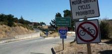
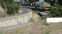
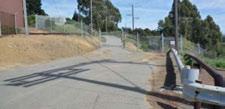
11 Project Overview - Castro Street Terminus NORTH NORTH NORTH OFFICE HILL RETENTION POND 1 2 RETENTION POND 3 4 RET. WALL 3
12 Project Overview Marine Street Intersection NORTH OFFICE HILL (Chevron) RETENTION POND
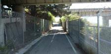
13 Project Overview Freeway Narrows NORTH OFFICE HILL (Chevron)
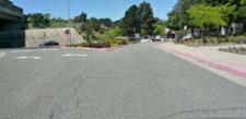
14 Project Overview Scofield Crossing & Toll Plaza LONG WHARF SAN FRANCISCO CSCO BAY NORTH TOLL PLAZA TO SAN RAFAEL
15 NORTH CONSTRAINTS

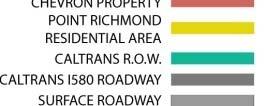
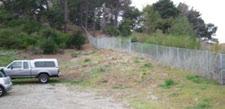
16 Land Uses and Ownership

17 Utilities and Infrastructure

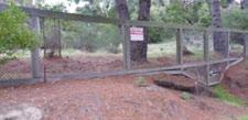
18 Heightened Security Areas


19 Geology/Soil Conditions


20 Topography/Slope p p Gradients

21 Site Biology
22 NORTH ALIGNMENT ALTERNATIVES
23 San Francisco Bay Trail Connection Castro Street to Richmond-San Rafael Bridge ALTERNATIVES CONSIDERED WESTERN DR. RICHMOND-SAN RAFAEL BRIDGE NORTH


24 San Francisco Bay Trail Connection Castro Street to Richmond-San Rafael Bridge RECOMMENDED ALTERNATIVES WESTERN DR. RICHMOND-SAN RAFAEL BRIDGE NORTH FREEWAY 580 ALT. 4.2 ALT. 5B
25 Specific Design Criteria Width & User Separation Grades & Cross Slopes Design Speed & Surfaces Horizontal Curves & Sightlines Utility & Infrastructure Clearance Construction & Constructability Railings & Fencing Signage g & Striping Gratings & Drainage Lighting & Call Boxes Graffiti, Theft & Vandalism Landscaping Access Control
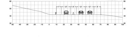
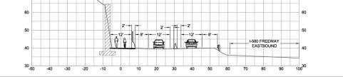
26 Section FF at Marine Street Off-Ramp
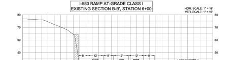
27 Section EE On-Grade Trail at East Retaining i Wall
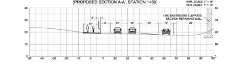
28 Section DD Elevated Structure at East Retaining i Wall
29 Bridge to Trail Transition Berkeley, CA
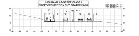
30 Section CC at West Retaining Wall


31 Detail Comparison: Retaining Walls Large wall & fences against edge of pathway not preferred. Better to step retaining walls for more human scale and planting. Pull fences away from edge of pathway
32 Bridge Area aerial view from south
33 Bridge Area plan view
34 Section BB at Western Drive


35 Section AA at Chevron Tank
36
37
38
39
40
41 San Francisco Bay Trail Connection Castro St. TO Richmond-San Rafael Bridge COMMENTS
42 San Francisco Bay Trail Connection Castro Street to Richmond-San Rafael Bridge NEXT STEPS Proje ect Initia ation Visio oning / Com Revie ew /Com mment Draft Repo ort ment Draft Report /Proj ect Desc cription Agen ncy / Pub blic Com ment Adop ption Richmond Bicycle /Pedestrian Advisory Committee Dec, 2010 Public Workshop Jan, 2011 Tonight Richmond Richmond Design City Review Council Board CEQA Review Richmond City Council
43 NORTH Enclosure Alternatives ti
44 Fully Enclosed with Solid Roof and 1-inch mesh
45 Fully Enclosed with 1-inch mesh
46 Fully Enclosed with 1-inch mesh
47 NORTH ALTERNATIVES DETAILS
48
49
Community Workshop. City of Richmond. January 25, 2011 SF Bay Trail Connection - Castro St to Richmond-San Rafael Bridge
 Community Workshop City of Richmond 1 City of Richmond Lead Agency BPAC Richmond Community ABAG Design and Process Funding Partner Caltrans Environmental; Process Review Design Process State and Federal
TOWN COUNCIL / PLANNING COMMISSION
 Workshop #3 TOWN COUNCIL / PLANNING COMMISSION January 20, 2011 Consultant Team In Attendance Tonight BMS Design Group Nevada City and San Francisco Michael Smiley, AICP, ASLA Partner-in-Charge Nancy L.
CENTRAL ESTUARY PLAN AVISION FOR OAKLAND S WATERFRONT
 Central Estuary Plan A VISION FOR OAKLAND S WATERFRONT Specific Plan and Environmental Assessment Presentation to the Parks and Recreation Advisory Commission December 9, 2009 This Afternoon s Presentation
4/8/2015 Item #10D Page 1
 MEETING DATE: April 8, 2015 PREPARED BY: Christy Villa, Associate Civil Engineer DEPT. DIRECTOR: Glenn Pruim DEPARTMENT: Public Works CITY MANAGER: Larry Watt SUBJECT: NORTH COAST HIGHWAY 101 STREETSCAPE
SAN MARTIN BOULEVARD OVER RIVIERA BAY PROJECT DEVELOPMENT & ENVIRONMENT (PD&E) STUDY
 STUDY") KICK-OFF PRESENTATION SAN MARTIN BOULEVARD OVER RIVIERA BAY PROJECT DEVELOPMENT & ENVIRONMENT (PD&E) STUDY PROJECT IDENTIFICATION NUMBER (PID): #001036A May 13, 2015 1 2 PROJECT LOCATION PROJECT HISTORY
KICK-OFF PRESENTATION SAN MARTIN BOULEVARD OVER RIVIERA BAY PROJECT DEVELOPMENT & ENVIRONMENT (PD&E) STUDY PROJECT IDENTIFICATION NUMBER (PID): #001036A May 13, 2015 1 2 PROJECT LOCATION PROJECT HISTORY
BRADENTON RIVERWALK EXPANSION MASTER PLAN
 BRADENTON RIVERWALK EXPANSION MASTER PLAN INTRODUCTION & AGENDA Process Update Community Engagement Summary Center for Active Design (CfAD) Recommendations Context and Existing Conditions Master Plan Alternatives
SCTPO Project Summary September 2014
 A1A MULTIMODAL CORRIDOR PLANNING AND ENGINEERING ANALYSIS Florida Department of Transportation SCTPO Project Summary September 2014 PRESENTATION FOOTER Meeting Agenda What We Plan To Do Project Background
The Illinois Department of Transportation and Lake County Division of Transportation. Route 173, including the Millburn Bypass
 The Illinois Department of Transportation and Lake County Division of Transportation welcome you to this Public Hearing for U.S. Route 45 from Illinois Route 132 to Illinois Route 173, including the Millburn
PG&E WINTERS GAS OPERATIONS AND TECHNICAL TRAINING CENTER
 PG&E WINTERS GAS OPERATIONS AND TECHNICAL TRAINING CENTER CEQA scoping Meeting March 19 th, 2014 Winters City Council Chambers - 6:30 pm AGENDA FOR THE MEETING 6:30 Welcome (John Donlevy) 6:40 Overview
Creating Complete Roadway Corridors:
 Creating Complete Roadway Corridors: The AASHTO Guide to Transportation Landscape Architecture and Environmental Design NCHRP Project 15-33 Status Report AASHTO Standing Committee on Design Technical Committee
India Basin/Hunters Point Shoreline Community Workshop May 21, 2008
 India Basin/Hunters Point Shoreline Community Workshop May 21, 2008 Workshop Agenda Welcome Process Overview Context & Existing Conditions Presentation of Draft Concepts Land Use and Open Space Priorities
Welcome to the Sellwood Bridge Project Pre-Construction Open House
 Welcome to the Sellwood Bridge Project Pre-Construction Open House 5:30 7:30 p.m. Please sign in here Information stations and project staff are located throughout the room. Goals for Tonight s Meeting
SHERIDAN PARKING STRUCTURE PUBLIC INFORMATION MEETING November 11, :00 pm - 8:00 pm
 SHERIDAN PARKING STRUCTURE PUBLIC INFORMATION MEETING November 11, 2010 6:00 pm - 8:00 pm 1 Project Area 2 Sheridan Parking Structure RTD Ownership 3 Project Elements Structure and amenities include: 1.
California Environmental Quality Act (CEQA) Environmental Review Process
 Environmental Review Process") California Environmental Quality Act (CEQA) Environmental Review Process Los Angeles Union Station Forecourt and Esplanade Improvements constitute a Project Los Angeles County Metropolitan Transportation
California Environmental Quality Act (CEQA) Environmental Review Process Los Angeles Union Station Forecourt and Esplanade Improvements constitute a Project Los Angeles County Metropolitan Transportation
Introduction and Overview
 Introduction and Overview Articulate local values and priorities Guide land use and development decisions Coordinate transportation, infrastructure, and City services with expected growth and available
Project Overview. Get Involved. Public Information Meeting. Contact Information
 Get Involved VDOT representatives will review and evaluate information received as a result of this meeting. Please fill out the comment sheet provided in this brochure if you have any comments or questions.
Illustrative Development Plan
 Illustrative Development Plan December 7, 005 045 Sansome St., Studio 3 San Francisco, CA 94 Area A - Increase visibility to waterfront and aquatic center from the Embarcadero - Provide streets rather
LARKSPUR SMART STATION AREA PLAN Scope of Work
 LARKSPUR SMART STATION AREA PLAN Scope of Work RECIPIENT (City of Larkspur), with professional consulting assistance, shall develop a SMART Station Area Plan and Station Area Plan Program Environmental
TONIGHT S PURPOSE INFORMATION SESSION CANORA & WEST JASPER PLACE SIDE STREETS CONCEPT PLANNING STUDY. Share draft side streets concept plan
 TONIGHT S PURPOSE Share draft side streets concept plan INFORMATION SESSION Share information and answer questions Tuesday, December 1, 2015 Drop-In 5:30 8:00 PM West Jasper/Sherwood Community Hall TONIGHT
Transbay Folsom Streetscape Project 2 nd Street to Spear Street Community Update July 16, 2015
 Transbay Folsom Streetscape Project 2 nd Street to Spear Street Community Update July 16, 2015 A2 Agenda Welcome and introductions Project history and goals Project overview and next steps Questions and
Views from the Bridge
 Chapter 2 Views from the Bridge Alternative 2A would primarily have adverse visual impacts to views from the Bridge, with the exception of a strongly adverse visual impact from Viewpoint 11 (Car View East)
This page left intentionally blank.
 July 2012 This page left intentionally blank. Table of Contents Appendix A : Project Development Checklist Appendix B: At-Grade Rail Crossings Appendix C: Maintenance and Operations Examples Appendix D:
UNIVERSITY OF CALIFORNIA, SAN DIEGO
 UNIVERSITY OF CALIFORNIA, SAN DIEGO BERKELEY DAVIS IRVINE LOS ANGELES MERCED RIVERSIDE SAN DIEGO SAN FRANCISCO SANTA BARBARA SANTA CRUZ CAMPUS PLANNING 9500 GILMAN DRIVE # 0074 TEL: (858) 534 6515 LA JOLLA,
SAN RAFAEL GENERAL PLAN 2040 INTRODUCTION AND OVERVIEW
 SAN RAFAEL GENERAL PLAN 2040 INTRODUCTION AND OVERVIEW Steering Committee Presentation February 14, 2018 Purpose of General Plan Guide land use and development decisions Coordinate transportation, infrastructure,
Mission Bay Park Master Plan Update: Fiesta Island Amendment (Information) Mission Bay Park Committee October 3, 2017
 Mission Bay Park Committee October 3, 2017") Mission Bay Park Master Plan Update: Fiesta Island Amendment (Information) Mission Bay Park Committee October 3, 2017 Tonight s Agenda Introduction & Project Overview Proposed Circulation Changes Overview
Mission Bay Park Master Plan Update: Fiesta Island Amendment (Information) Mission Bay Park Committee October 3, 2017 Tonight s Agenda Introduction & Project Overview Proposed Circulation Changes Overview
2. AGENCY COORDINATION AND PUBLIC INVOLVMENT
 2. AGENCY COORDINATION AND PUBLIC INVOLVMENT This chapter discusses the process carried out for conducting agency coordination and public involvement activities. TECHNICAL ADVISORY COMMITTEE A Technical
NOTICE OF PREPARATION
 NOTICE OF PREPARATION To: All Interested Parties Subject: Notice of Preparation of an Environmental Impact Report From: City of Petaluma Address: 11 English Street, Petaluma, CA 94952-2610 Contact: Heather
SOUTHWEST TRANSITWAY (STAGE 2) PUBLIC OPEN HOUSE
 PUBLIC OPEN HOUSE") WELCOME! SOUTHWEST TRANSITWAY (STAGE 2) PUBLIC OPEN HOUSE Monday, November 18, 2013 3:30 to 5:30PM and 7:00 to 9:00PM Tuesday, November 19, 2013 3:30 to 5:30PM and 7:00 to 9:00PM Welcome to the Southwest
WELCOME! SOUTHWEST TRANSITWAY (STAGE 2) PUBLIC OPEN HOUSE Monday, November 18, 2013 3:30 to 5:30PM and 7:00 to 9:00PM Tuesday, November 19, 2013 3:30 to 5:30PM and 7:00 to 9:00PM Welcome to the Southwest
PLANNING AND NATURAL RESOURCES COMMITTEE. Public Access Conceptual Design Alternatives for the Red Barn Area of La Honda Creek Open Space Preserve
 PLANNING AND NATURAL RESOURCES COMMITTEE R-17-56 May 9, 2017 AGENDA ITEM AGENDA ITEM 2 Public Access Conceptual Design Alternatives for the Red Barn Area of La Honda Creek Open Space Preserve GENERAL MANAGER
M i s s i o n B a y W a t e r f r o n t
 114 M i s s i o n B a y W a t e r f r o n t Character of the Area: The Mission Bay Waterfront extends from Pier 48 at China Basin Channel to 18th Street in the Central Basin. This area of the waterfront
INDEPENDENCE BOULEVARD AREA PLAN. June 24, 2008
 INDEPENDENCE BOULEVARD AREA PLAN Public Meeting #1 June 24, 2008 Tonight s Agenda Introduction Welcome and Ground Rules Overview Presentation Purpose of the Plan What Brings Us Here? A Tour of the Corridor
ARGENTA TRAIL (CSAH 28/63) REALIGNMENT SOUTH PROJECT (CP 63-25)
 REALIGNMENT SOUTH PROJECT (CP 63-25)") ARGENTA TRAIL (CSAH 28/63) REALIGNMENT SOUTH PROJECT (CP 63-25) Preliminary Design Report February 2015 Prepared For: City of Inver Grove Heights Dakota County Prepared By: Kimley-Horn and Associates,
ARGENTA TRAIL (CSAH 28/63) REALIGNMENT SOUTH PROJECT (CP 63-25) Preliminary Design Report February 2015 Prepared For: City of Inver Grove Heights Dakota County Prepared By: Kimley-Horn and Associates,
Reinventing Miner Avenue as a
 Reinventing Miner Avenue as a Complete Street Reinventing Miner Avenue as a Complete Street Agenda Project Overview / Introductions Previous Meeting Recap Economic Considerations Opportunities & Constraints
City of Los Angeles Department of Public Works
 City of Los Angeles Department of Public Works Environmental Scoping Meeting for the Proposed Sixth Street Park, Arts, River & Connectivity Improvements (PARC) Project May 3, 2017 1 Agenda Introductions
EUREKA VALLEY / HARVEY MILK MEMORIAL BRANCH LIBRARY COMMUNITY MEETING 3 WEDNESDAY, APRIL 5, 2017
 EUREKA VALLEY / HARVEY MILK MEMORIAL BRANCH LIBRARY COMMUNITY MEETING 3 WEDNESDAY, APRIL 5, 2017 Prepared by: San Francisco Public Works Building, Design, & Construction Landscape Architecture Section
I-90 Mississippi River Bridge & Interchange Project
 I-90 Mississippi River Bridge & Interchange Project Presentation Outline I. Background: Context & Need for Project II. Preferred Alternative Overview III. Project Development IV. Project Management Tools
Cobb County Design Guidelines Mableton Parkway & Veterans Memorial Highway Community Design Workshop January 12, 2017
 Community Design Workshop January 12, 2017 Agenda Opening Remarks / Introductions Scope of Work Existing Conditions Key Issues / Opportunities VPS Summary Draft Vision & Goal Statement Implementation Concepts
SH 199 Corridor Master Plan. Community Meeting No. 2 May 31, 2017
 Community Meeting No. 2 May 31, 2017 Transportation Projects On or Near SH 199 SH 199 from 0.3 miles south of FM 1886 to south end of Lake Worth bridge Construct freeway mainlanes and frontage roads 10-Year
Community Meeting #1: Project Kick Off
 Community Meeting #1: Project Kick Off November 17, 2015 What are 3 things you like about Downtown Gilroy that you want to hold onto in the future? Please write them down and share with us! Tonight s Meeting
DESIGN & GREEN INFRASTRUCTURE UPDATE December 13, 2016
 DESIGN & GREEN INFRASTRUCTURE UPDATE December 13, 2016 Welcome & Introduction Michael J. Finn, P.E. City Engineer Summary of Public Outreach to Date Ground the work in established principles December 2015
Reconstruction Project. Wayzata Task Force Meeting September 3, 2009
 CSAH 101 Reconstruction Project Wayzata Task Force Meeting September 3, 2009 Agenda 700 7:00 Re-Introductions ti 7:05 2008 Activity Recap / 2009 Activities-to-date 7:10 Discussion of Layout Revisions (per
Scope of Services. River Oaks Boulevard (SH 183) Corridor Master Plan
 Corridor Master Plan") Scope of Services River Oaks Boulevard (SH 183) Corridor Master Plan PROJECT AREA The project area consists of the River Oaks Boulevard (SH 183) corridor bounded by SH 199 at the northern end and the Trinity
Scope of Services River Oaks Boulevard (SH 183) Corridor Master Plan PROJECT AREA The project area consists of the River Oaks Boulevard (SH 183) corridor bounded by SH 199 at the northern end and the Trinity
CITY OF VAUGHAN EXTRACT FROM COUNCIL MEETING MINUTES OF JUNE 7, 2016
 Item 5, Report No. 26, of the Committee of the Whole (Working Session), which was adopted without amendment by the Council of the City of Vaughan on June 7, 2016. 5 MUNICIPAL CLASS ENVIRONMENTAL ASSESSMENT
Downtown Cleveland Alliance/Tremont
 Cleveland Innerbelt Urban Design Stakeholder Workshops Downtown Cleveland Alliance/Tremont May 4, 2007 2007 Activities: What We re Going To Be Doing. March 8, 2007 Initiate Urban Design Aesthetic Study
4.1 Build Alternative 1 Construction Phasing
 SECTION 4 Implementation Plan This section discusses potential segmentation of the build alternatives into multiple projects for implementation of improvements to the NSH from Rabbit Creek Road to 36th
Route 1 Corridor Study
 Route 1 Corridor Study Westbrook, Connecticut A Vision for the Connecticut Shoreline Public Informational Meeting July 28, 2015 Lower Connecticut River Valley Council of Governments Fitzgerald & Halliday,
Expo Light Rail Line. Expo Line Community Meeting Phase 2 Design Update November 2011
 Expo Line Community Meeting Phase 2 Design Update November 2011 Meeting Agenda Phase 2 Design Update Meeting Meeting Purpose and Format Project Status Update Overview of Design Progress Next Steps Open
Dumbarton Transportation Corridor Study
 Dumbarton Transportation Corridor Study SPD&S Committee August 2, 2017 Agenda Item # 4 Two Bridges 2 Complex Corridor 3 Headlines Corridor requires phased improvements Solutions require consensus, other
MISSISSIPPI GORGE REGIONAL PARK MASTER PLAN
 MISSISSIPPI GORGE REGIONAL PARK MASTER PLAN Minneapolis Park and Recreation Board CAC MEETING #1 APRIL 23, 2018 AGENDA Mississippi Gorge Regional Park Master Plan CAC #1 01 / Welcome and Calling Circle
PARKLET PROPOSAL PACKAGE & PROCESS
 500.3 I PARKLETS The term parklet refers to a small temporary constructed seating or community gathering area over an on-street parking space or an extension of the sidewalk into the operating State highway
Public may provide comments on the GDP within the next two weeks (December 24)
") 25/70 General Development Plan (GDP) Public Meeting Wednesday, December 10, 2014 6:00 8:00 P.M. District 1 Police Station Community Room 1311 W 46th Ave, Denver, CO 80211 Council Woman Montero: This particular
25/70 General Development Plan (GDP) Public Meeting Wednesday, December 10, 2014 6:00 8:00 P.M. District 1 Police Station Community Room 1311 W 46th Ave, Denver, CO 80211 Council Woman Montero: This particular
Good Design Guidelines for Downtown. Preliminary Findings and Recommendations
 Good Design Guidelines for Downtown Preliminary Findings and Recommendations City Council Meeting - February 5, 2017 Advisory Committee Team: Larry Paul: Planning Commission /Architect Bruce Bagnoli: Business
WELCOME 50 street cp rail grade separation + road widening. public information session #1 June 26, pm to 8 pm
 WELCOME 50 street cp rail grade separation + road widening public information session #1 June 26, 2018 5 pm to 8 pm session purpose To provide residents, businesses, and users of 50 Street with the opportunity
Devil s Slide Coastal Trail Improvements Project. County of San Mateo
 County of San Mateo Project History Measure T Nov.1996 Plans and Permits Task Force meetings Hired a team Board support Budget Project Overview Programming and Linkages Park hours Multi use trail Pedestrians
Railyard Alternatives and I-280 Boulevard Feasibility Study. MTA Board Meeting May 6, 2014
 Railyard Alternatives and I-280 Boulevard Feasibility Study MTA Board Meeting May 6, 2014 Planned Infrastructure Major pieces of new infrastructure are planned including: Downtown Rail Extension (DTX)
International Blvd. TOD Plan Public Workshop #1
 International Blvd. TOD Plan Public Workshop #1 Add photos or project images September 21 and 22, 2010 Workshop Purpose Introduce the public to the Project Review and discuss the existing conditions analysis
City Council Special Meeting AGENDA ITEM NO. C.
 City Council Special Meeting AGENDA ITEM NO. C. DATE: 01/04/2019 TO: Honorable Mayor and City Council Members SUBJECT: Transit Villages Specific Plan project Study Session (Development Services Director
BENJAMIN BANNEKER PARK FRAMEWORK PLAN (PLAN ADOPTION)
") BENJAMIN BANNEKER PARK FRAMEWORK PLAN (PLAN ADOPTION) COUNTY BOARD MEETING DECEMBER 16, 2017 County Board Consideration: Adopt the Benjamin Banneker Park Framework Plan and Design Guidelines Framework
BENJAMIN BANNEKER PARK FRAMEWORK PLAN (PLAN ADOPTION) COUNTY BOARD MEETING DECEMBER 16, 2017 County Board Consideration: Adopt the Benjamin Banneker Park Framework Plan and Design Guidelines Framework
Welcome to the. Open House
 Welcome to the 5th Street to Kinsman Road Open House November 14 5:30 7:00 p.m. Please sign in Project Overview In December 2016, City Council adopted SW 5th Street as the preferred alignment to connect
Welcome to the LYNX Blue Line Extension Transit Station Area Plans Public Workshop No. 3. Presentation will begin at 6:00 P.M.
 Welcome to the LYNX Blue Line Extension Transit Station Area Plans Public Workshop No. 3 Presentation will begin at 6:00 P.M. Meeting Agenda Blue Line Extension (BLE) Project Update LYNX Blue Line Extension
NORTH CLAYMONT AREA MASTER PLAN COMMUNITY WORKSHOP #1 FEBRUARY 3, 2016
 NORTH CLAYMONT AREA MASTER PLAN COMMUNITY WORKSHOP #1 FEBRUARY 3, 2016 1. Introduction To the team and to the Plan Planning Partners The Claymont Community WILMAPCO New Castle County Claymont Renaissance
Municipality of Anchorage, Alaska Parks & Recreation Department
 Municipality of Anchorage, Alaska Parks & Recreation Department 632 W. 6 th Avenue, Suite 630 P.O. Box 196650 Anchorage, AK 99519 Tel 907-343-4355 URL www.muni.org/departments/parks MEMORANDUM Date: October
Saranac River Trail Greenway C O N D I T I O N S R E P O R T
 Saranac River Trail Greenway C O N D I T I O N S R E P O R T City of Plattsburgh Clinton County, NY For: Clinton County Final Issued: March 22, 2017 This document was prepared for the New York State Department
AvalonBay Communities + BRIDGE Housing. Mission Housing Habitat for Humanity Pacific Union Development Corporation
 AvalonBay Communities + BRIDGE Housing Mission Housing Habitat for Humanity Pacific Union Development Corporation Tonight s Agenda Recap of discussion from last CAC meeting Updates on meetings with Stakeholders
City of San Juan Capistrano PROJECT PRESENTATION NORTHWEST OPEN SPACE COMMUNITY PARK (CIP 09209) March 22, 2016 FOR THE PROJECT PRESENTATION
 March 22, 2016 FOR THE PROJECT PRESENTATION") City of San Juan Capistrano PROJECT PRESENTATION PROJECT PRESENTATION FOR THE NORTHWEST OPEN SPACE COMMUNITY PARK (CIP 09209) PLANNING COMMISSION 1 PROCESS & OBJECTIVES A. Develop a new Concept Plan for
City of San Juan Capistrano PROJECT PRESENTATION PROJECT PRESENTATION FOR THE NORTHWEST OPEN SPACE COMMUNITY PARK (CIP 09209) PLANNING COMMISSION 1 PROCESS & OBJECTIVES A. Develop a new Concept Plan for
Dumbarton Transportation Corridor Study. JPB Board of Directors September 7, 2017
 Dumbarton Transportation Corridor Study JPB Board of Directors September 7, 2017 Two Bridges 2 Complex Corridor 3 Context JPB led previous Dumbarton Rail design and environmental analysis via MOU Potential
CITY OF CHARLOTTESVILLE, VIRGINIA CITY COUNCIL AGENDA
 CITY OF CHARLOTTESVILLE, VIRGINIA CITY COUNCIL AGENDA Agenda Date: December 16, 2013 Action Required: Adoption of Resolution Presenter: Staff Contacts: Title: James E. Tolbert, AICP, Director of NDS James
CITY OF LARKSPUR Staff Report. August 21, 2013 Council Meeting UPDATE ON TRANSPORTATION AUTHORITY OF MARIN (TAM) GREENBRAE CORRIDOR WORKING GROUP
 GREENBRAE CORRIDOR WORKING GROUP") AGENDA ITEM 7.1 CITY OF LARKSPUR Staff Report August 21, 2013 Council Meeting DATE: August 16, 2013 TO: FROM: SUBJECT: Honorable Mayor Hillmer and Members of the City Council Dan Schwarz, City Manager
AGENDA ITEM 7.1 CITY OF LARKSPUR Staff Report August 21, 2013 Council Meeting DATE: August 16, 2013 TO: FROM: SUBJECT: Honorable Mayor Hillmer and Members of the City Council Dan Schwarz, City Manager
Executive Summary. NY 7 / NY 2 Corridor
 Executive Summary NY 7 / NY 2 Corridor Transportation and Land Use Study December 2005 Prepared for: Town of Colonie Capital District Transportation Committee Prepared by: Introduction: Land use decisions
STUDY AREA. Tonight s Agenda. Project Tasks Completed. Next Steps. Town of Oyster Bay Eastern Waterfront Community Vision & Revitalization Plan
 Town of Oyster Bay Eastern Waterfront Community Vision & Revitalization Plan Public Meeting January 27, 2009 Opening Remarks Presentation Tonight s Agenda Introduction Study Area Overview Public Participation
Speedway Mall Project Frequently Asked Questions
 Speedway Mall Project Frequently Asked Questions These FAQs will continue to be updated as new questions arise. Purpose of the Project and Uses of the Mall Q: Why is this project being done? A: The 1999
Transportation Research Center
 Increasing Design Flexibility in the AASHTO Green Book Your Department Name Presentation to AASHTO Subcommittee on Design Doug Harwood, MRIGlobal July 2017 Transportation Research Center Resolution of
Rapid City Planning Commission Rezoning Project Report
 Rapid City Planning Commission Rezoning Project Report April 5, 2018 Item # 4 Applicant Request(s) Case # 18RZ008 Rezoning request from General Agricultural District to Low Density Residential District
PROJECTS AND THE PUBLIC ART MASTER PLAN
 MEMO TO: PUBLIC ART STEERING COMMITTEE MEMBERS FROM: SHARI COOPER, DEVELOPMENT PROJECT COORDINATOR DATE: FEBRUARY 24, 2017 SUBJECT: AGENDA ITEM 5.A: PUBLIC ART PROJECT FOR 2017-18 BACKGROUND One of the
3. VISION AND GOALS. Vision Statement. Goals, Objectives and Policies
 Vision Statement Queen Creek s interconnected network of parks, trails, open spaces and recreation opportunities provide safe and diverse activities and programs that sustain its unique, small town, equestrian
Citizen Advisory Group Meeting 5: Land Use April 14, 2011
 Citizen Advisory Group Meeting 5: Land Use April 14, 2011 Meeting Agenda 1. Background Review 2. Transportation Follow-up 3. PED Overlay Approach 4. Land Use Mapping 5. Group Exercise 6. Wrap-up and Next
Fisherman s Wharf Public Realm Plan
 Fisherman s Wharf Public Realm Plan SPUR Presentation July 11, 2008 3 February 2010 WHY A PUBLIC REALM PLAN? Public Life 1900 1950 1965 2000 Mainstreet Copenhagen in 100 years From nessesary to optional
Public Information Meeting
 Today s Agenda: Open House - (5:30-7PM) Presentation- (5:45PM) County Project: P-5351-1 FDOT Project :242172-1-58-01 Public Information Meeting Technical Design Team Volusia County Jim White, P.E.- Project
Neighborhood Conservation (NC) Program CONCEPT DESIGN REVIEW MEETING NOTES
 Program CONCEPT DESIGN REVIEW MEETING NOTES") Neighborhood Conservation (NC) Program CONCEPT DESIGN REVIEW MEETING NOTES PROJECT NAME: PROJECT #: DATE: TO: FROM: 13 th St N Z098 April 8, 2015 (Meeting date March 26 th at 7:00pm) Arlington County Conference
Neighborhood Conservation (NC) Program CONCEPT DESIGN REVIEW MEETING NOTES PROJECT NAME: PROJECT #: DATE: TO: FROM: 13 th St N Z098 April 8, 2015 (Meeting date March 26 th at 7:00pm) Arlington County Conference
Dyersville Downtown Plan. Open House October 24, 2017
 Dyersville Downtown Plan Open House October 24, 2017 What is a Comprehensive Plan? - Vision - Guidance for decisions - Basis for regulations What is a Downtown Plan? - Understand priorities - Identify
Summary Community Workshop #6 Beacon Day School Saturday, November 14, :00 a.m. 12:00 p.m.
 Summary Community Workshop #6 Beacon Day School Saturday, November 14, 2009 9:00 a.m. 12:00 p.m. Workshop Format and Process The City of Oakland is preparing a Specific Plan that will help define and determine
MOBILITY35 AESTHETICS
 MOBILITY35 AESTHETICS Aesthetics Working Group 3 March 29, 2016 What we heard regarding three themes Connectivity: Improve east/west pedestrian connections Safe and well marked Local identity defined by
SF REC & PARK STANYAN STREET IMPROVEMENT. Supervisor London Breed District 5. Project Manager Dan Mauer Recreation and Parks Department
 SF REC & PARK STANYAN STREET IMPROVEMENT COMMUNITY MEETING #3 THURSDAY, JANUARY 25 TH, 2018 Supervisor London Breed District 5 Project Manager Dan Mauer Recreation and Parks Department Design Team William
DRAFT Civic Center Station Area Plan. Executive Summary
 DRAFT Civic Center Station Area Plan Executive Summary This project is funded in part through the Metropolitan Transportation Commission s Station Area Planning Program. The preparation of this report
Southern Gateway Project and Public Green
 Southern Gateway Project and Public Green Transportation and Trinity River Project Committee May 23, 2016 Purpose of Presentation Provide the history and an overview of the Southern Gateway Project (SGP)
Beckett Bridge PD& E Study. Presentation to: Board of County Commissioners
 Beckett Bridge PD& E Study Presentation to: Board of County Commissioners October 22, 2013 Introduction Study Began January 2012 Alternatives Presented to Commission October 2013 Alternatives Presented
SR-2 Freeway Terminus Improvement Project
 SR-2 Freeway Terminus Improvement Project Welcome! Public Hearing, Mayberry Elementary June 16, 2009, 6:30 p.m. 8:30 p.m. Agenda 6:30 PM 6:50 PM Registration and Open House 6:50 PM 7:00 PM Welcome and
Route 7/15 Norwalk. Route 7/15 Norwalk Project Project Advisory Committee Meeting #5. Wednesday, November 14 th, Norwalk City Hall
 Route 7/15 Norwalk Project Project Advisory Committee Meeting #5 Route 7/15 Norwalk PAC Meeting #5 November 14, 2018 Wednesday, November 14 th, Norwalk City Hall Route 7/15 Norwalk - AGENDA Introductions
WAC #7 3/14/14. Coachella General Plan Update
 WAC #7 3/14/14 Coachella General Plan Update Agenda 2 Introductions Public Draft General Plan Overview and Discussion of Next Steps Implementation and Evaluation Health Element Process Evaluation (discussion)
CITY OF BEACON NOTICE TO LANDSCAPE ARCHITECTS GENERAL INFORMATION AND REQUEST FOR PROPOSALS
 CITY OF BEACON NOTICE TO LANDSCAPE ARCHITECTS GENERAL INFORMATION AND REQUEST FOR PROPOSALS The City of Beacon (the CITY) is issuing this Request for Proposals (RFP) for the selection of a landscape architect
Pennsy Greenway Trail
 Town of Schererville Pennsy Greenway Trail DES. #s: 0401062, 1173595 & 1382661 Construction of Pennsy Greenway Trail beginning at Wilhelm Street and continuing northwest along the former Penn Central railroad
NORTH-SOUTH CORRIDOR STUDY EXECUTIVE SUMMARY. Executive Summary
 Executive Summary Background As congestion continues to affect mobility in the region, the Ozarks Transportation Organization (OTO) is particularly concerned with traffic movement. The North-South Corridor
AGENDA ACTION ITEMS INFORMATION ITEMS
 NOACA Bicycle and Pedestrian Advisory Council Meeting Friday, March 21 st, 2014 10:30 a.m. NOACA Office 1299 Superior Avenue Cleveland, Ohio 44114 Phone: (216) 241-2414; website: www.noaca.org AGENDA ACTION
(blank page) WestConnex New M Roads and Maritime Services Environmental impact statement
 WestConnex New M Roads and Maritime Services Environmental impact statement") (blank page) WestConnex New M5 5-42 (blank page) WestConnex New M5 5-44 5.5 Tunnels 5.5.1 Main alignment tunnels The main alignment tunnels would be about nine kilometres long, with the western tunnel
(blank page) WestConnex New M5 5-42 (blank page) WestConnex New M5 5-44 5.5 Tunnels 5.5.1 Main alignment tunnels The main alignment tunnels would be about nine kilometres long, with the western tunnel
Clay Street Bridge Replacement Project
 Clay Street Bridge Replacement Project Frequently Asked Questions (FAQs) No. 2 April 4, 2018 The project is located in downtown Placerville on Clay Street between US Highway 50 and Main Street and Cedar
City of Hermosa Beach Administrative Policy #
 City of Hermosa Beach Administrative Policy # SUBJECT: Living Streets Policy Date: Approved by: City Council Authority: Public Works Department & Community Development Department Mayor, PURPOSE The City
Pine Hills Bus Transit Center Community Design Workshop. Presentation April 21, 2018
 Pine Hills Bus Transit Center Community Design Workshop Presentation April 21, 2018 1 Today s Workshop Welcome and Overview (10:00-1015 AM) Site Programming (10:15-10:45 AM) InfraWorks Demo (10:45-11:00
Tysons-Old Meadow Road Bike/Ped Improvements
 Tysons-Old Meadow Road Bike/Ped Improvements Design Workshop #2 Thursday, November 28, 2017, 7:00 pm to 9:00 pm Westgate Elementary School, Falls Church, VA Fairfax County Agenda Open house 7:00 pm 7:15
PROJECT BACKGROUND. Preliminary Design Scope and Tasks
 PROJECT BACKGROUND Preliminary Design Scope and Tasks The purpose of this Study is the development of preliminary designs for intersection improvements for Trunk Highway (TH) 36 at the intersections of
July 12, Columbus City Council City Hall 90 West Broad Street Columbus, OH RE: I-70/71 Columbus Crossroads Project
 OHIO DEPARTMENT OF TRANSPORTATION DISTRICT 6 400 EAST WILLIAM STREET DELAWARE, OHIO 43015 800.372.7714 Columbus City Council City Hall 90 West Broad Street Columbus, OH 43215-9015 RE: I-70/71 Columbus