Present. and. Future
|
|
|
- Caren Randall
- 6 years ago
- Views:
Transcription
1 Present and Future
2
3 July from MC 85 to I-17 included in the Regional Freeway System May 1989 State Transportation Board adopts Loop Revenues from Proposition 300 insufficient; 303 removed from RFS 1992/93 Interim two-lane roadway built Thomas Road to Grand Avenue
4 1998 State Transportation Board decides the State will not abandon 303 to local jurisdiction July 2000 IGA/JPA with MCDOT for O&M of interim roadway November 2004 MAG Regional Transportation Plan $1.42 billion for 303 March 2005 MCDOT renames roadway from Estrella Parkway to Bob Stump Memorial Parkway
5 July 2006 ADOT reassumes control of SR303L August 2006 ADOT completes DCR and EA from Happy Valley to I-17; 30% design begins June 2007 Final designs for Happy Valley Parkway to I-17 underway July 2008 Intersection improvements started at Bell, Cactus, and Waddell Roads (CMAR)

6 January 2009 Construction begins from Happy Valley to I-17 March 2009 ADOT completes DCR and EA for I- 10 to US60 FONSI received from FHWA July 2009 Final design contract issued for system interchange at I-10 August 2009 five final designers selected for segments from I-10 to US60
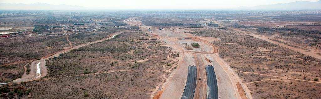
7 The Present
8 Depressed under I-10 Basically at-grade between Indian School Road and Greenway Road Depressed between Greenway Road and US 60 Elevated over US 60 System Interchanges at I-10, Northern Parkway, and US 60 Regional Drainage System from Bell Road south to Gila River
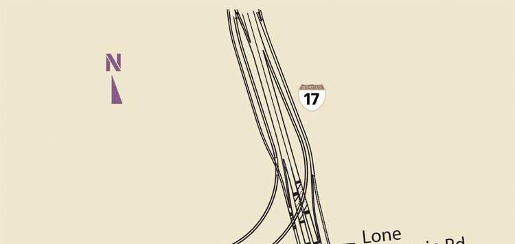
9 20-mile, divided freeway Freeway-to-freeway interchange at I-17 and Loop 303 Environmental study process US60 to Happy Valley Parkway scheduled to be completed early in 2010


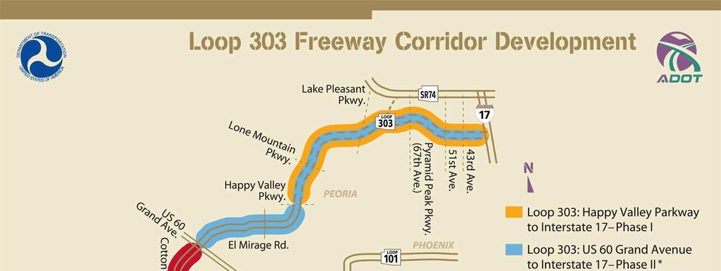
10 SR303L US60 to Happy Valley Parkway


11 Loop 303 Happy Valley to Lake Pleasant Parkways


12 Loop 303 Lake Pleasant Parkway to I-17
13 Happy Valley Parkway TI September 2006
14 Happy Valley Parkway TI May 2009


15 Happy Valley Parkway TI June 2009
16 Happy Valley Parkway TI August 2009


17 Happy Valley Parkway TI December 2009
18 Jomax Parkway TI September 2006


19 Jomax Parkway TI December 2009
20 Caterpillar Tanks Wash December 2009
21 Agua Fria River Crossing May 2009
22 Agua Fria River Crossing May 2009
23 Lake Pleasant Parkway TI September 2006
24 Lake Pleasant Parkway TI May 2009


25 Lake Pleasant Parkway TI December 2009
26 CAP Siphon Crossing
27 CAP Siphon Crossing May 2009
28 CAP Siphon Crossing May 2009


29 CAP Siphon Crossing September 2009


30 CAP Siphon Crossing December 2009
31 The Future
32 !"
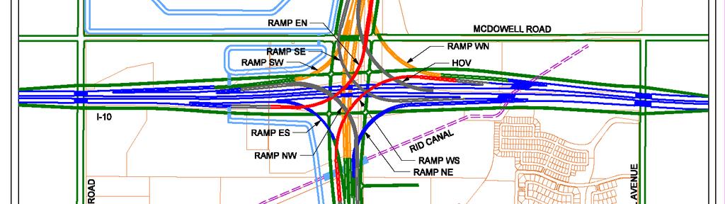
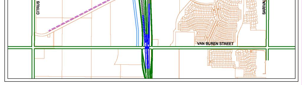
33 Future Interchange at I10
34 Future Northern Parkway TI
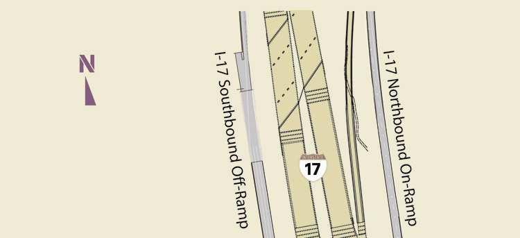
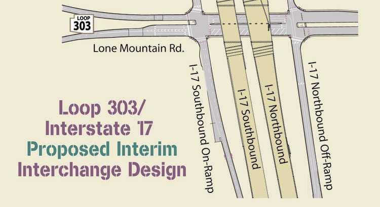
35 Future Interchange at I17 Interim Condition
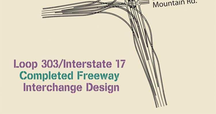
36 Future Interchange at I17 Final Condition
37 The Future FY11 I-10 System Interchange ($253M) Peoria to Waddell and Waddell to Mountain View combined project ($150M) FY12 Thomas to Camelback ($72M) Glendale to Peoria ($113M) Includes Northern Parkway Interim TI
38 The Future FY13 Camelback to Glendale ($62.9M) Design of US60 Interim Interchange ($4.5M) FY14 US60 (Grand) Interim Interchange ($48.4M)
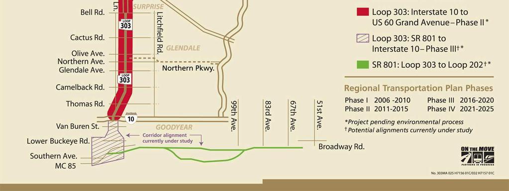
39 The Future RTP Phase III 6-lane freeway Grand to I-17 3 design segments, 2 construction segments
40 The Future RTP Phase IV Complete 6-lane freeway Grand to I-17 Design final US60 Interchange Design 2 segments MC85 to I-10
41 The Future RTP Phase V US60 Ultimate Interchange ($116.4M) Northern Parkway Ultimate TI ($80M) MC85 to I-10 Six Lane Freeway ($229M) Includes Phase 2 of I-10 System Interchange
42 Present and Future
43
44
45
46
47
48 Right-of-Way Dedication Owners dedicated approximately 300 feet In exchange, State to construct, operate, maintain, and improve Interim Roadway and ultimate freeway Automatic reverter clause was created Reverter of the unused portion of right-of-way if State failed to commence construction Reverter of any portion of right-of-way not used by ADOT should ADOT fail to commence construction of freeway by December 31, 2005
49 Proposed Freeway Passes Through Six Jurisdictions City of Goodyear Maricopa County City of Glendale (Luke Air Force Base) City of Surprise City of Peoria City of Phoenix
Interstate 10 Hassayampa Valley Roadway Framework Study. Chapter 6. Alternative Transportation Network Description and Evaluation.
 Interstate 10 Hassayampa Valley Roadway Framework Study Chapter 6 Alternative Transportation Network Description and Evaluation Prepared for Prepared by Table of Contents 6.1 Alternatives Considered...6-1
This page intentionally left blank
 This page intentionally left blank TABLE OF CONTENTS TABLE OF CONTENTS Preface... iii Introduction... 1 Scenic Corridor Overview... 1 Study Boundary... 2 Study Purpose... 2 Future Development Implications...
Welcome. Northern Segment of Hwy 100 I-90 to South of Madison Street Meeting Goals:
 Welcome Northern Segment of Hwy 100 I-90 to South of Madison Street Meeting Goals: - Review Environmental Assessment - Share Preferred Alternative -Receive Public Comments 2003 EA Preferred Alternative
WESTERN AREA PLAN ALSO KNOWN AS WESTERN AREA GENERAL PLAN UPDATE, APPLICATION NO. GP Adopted by Resolution No.
 WESTERN AREA PLAN ALSO KNOWN AS WESTERN AREA GENERAL PLAN UPDATE, APPLICATION NO. GP-00-04 Adopted by Resolution No. 3580 June 4, 2002 (Effective Date July 4, 2002) Updated for Content: February 14, 2012
I-4 Beyond the Ultimate. Florida Transportation Builders Association February 9, 2018
 I-4 Beyond the Ultimate Florida Transportation Builders Association February 9, 2018 FDOT: Improving Mobility & Safety in Central Florida FDOT is Designing and building a better I-4 through Central Florida
Route Planning and Environmental Assessment Study Highway 17 Four-Laning from Sudbury to Markstay GWP
 Route Planning and Environmental Assessment Study Highway 17 Four-Laning from Sudbury to Markstay GWP 5031-09-00 Presentation to City of Greater Sudbury Council: January 26, 2011 1 Roch Pilon, P.Eng. Head,
CITY OF LAKEWOOD 2012 THREE-MILE PLAN
 CITY OF LAKEWOOD 2012 THREE-MILE PLAN SECTION 1: INTRODUCTION This document constitutes the s Three-Mile Plan for the unincorporated area three miles in width around the City s perimeter, as required by
2. AGENCY COORDINATION AND PUBLIC INVOLVMENT
 2. AGENCY COORDINATION AND PUBLIC INVOLVMENT This chapter discusses the process carried out for conducting agency coordination and public involvement activities. TECHNICAL ADVISORY COMMITTEE A Technical
APPENDIX C Agency Scoping Meeting Materials
 I-11 Corridor Tier 1 EIS Scoping Summary Report Final APPENDIX C Agency Scoping Meeting Materials Agency Scoping Meeting Agendas Agency Scoping Meeting Presentation Agency Scoping Meeting Boards Agency
Pinal Regional Transportation Plan
 Pinal Regional Transportation Plan Central Arizona Governments 1075 S. Idaho Road, Suite 300 Apache Junction, AZ 85119 June 2017 INTRODUCTION The Regional Transportation Plan for Pinal County, overseen
AASHTO SUBCOMMITTEE ON DESIGN. June 15, 2006 MARK ROBINSON, P.E. DISTRICT 5 INTERSTATE PROGRAM MANAGER FLORIDA DEPARTMENT OF TRANSPORTATION
 AASHTO SUBCOMMITTEE ON DESIGN June 15, 2006 MARK ROBINSON, P.E. DISTRICT 5 INTERSTATE PROGRAM MANAGER FLORIDA DEPARTMENT OF TRANSPORTATION CENTRAL FLORIDA INTERSTATE 4 FACTS Trucks and Others 12% Tourist
DOMINION BOULEVARD CORRIDOR STUDY AND ECONOMIC DEVELOPMENT STRATEGIC PLAN A MODEL FOR CHESAPEAKE S FUTURE
 DOMINION BOULEVARD CORRIDOR STUDY AND ECONOMIC DEVELOPMENT STRATEGIC PLAN A MODEL FOR CHESAPEAKE S FUTURE Overview I. Draft Plan Process II. Draft Plan Overview a. Market Analysis b. Master Land Use Plan
SUNBRIDGE PARKWAY PRELIMINARY DESIGN STUDY. November 30, 2017
 SUNBRIDGE PARKWAY PRELIMINARY DESIGN STUDY November 30, 2017 Agenda Introductions and Overview Study Purpose Study Approach Key Analysis Components Study Context Existing Conditions Corridor Constraints
Exhibit A. SH 161 RTC Work Program of New Projects. Collin County
 Exhibit A SH 161 RTC Work Program of New Projects Collin County 0918-24-969 N/A 0918-24-970 N/A 0918-24-973 N/A 2351-01-020 N/A 2679-03-010 N/A On Exchange Parkway from US 75 to Allen Heights On Country
Yellowhead Corridor Area Structure Plan
 Yellowhead Corridor Area Structure Plan Office Consolidation June 2014 Prepared by: Current Planning Branch Sustainable Development City of Edmonton Bylaw 7044, as amended, was adopted by Council in April
MARGARITA ROAD. Harveston Community 1,900 homes centered around Harveston Lake DATE STREET ±180,000 CPD. Future French Valley Overpass On/Off Ramp
 10.58 NET COMMERCIAL ACRES FOR SALE MURRIETA CREEKSIDE JACKSON AVE & ARBORETUM WAY MURRIETA, CA MURRIETA SPRINGS PLAZA MURRIETA TOWN CENTER SCGA Golf Course FEATURES: Excellent freeway visibility MURRIETA
Dysart and Northern Commerce Center -- Military Compatibility Permit SWC Dysart Road and Northern Avenue Approved
 2 I. TABLE OF CONTENTS I. TABLE OF CONTENTS...3 II. LIST OF EXHIBITS/FIGURES...4 III. DEVELOPMENT TEAM...5 IV. INTRODUCTION AND PURPOSE OF REQUEST...6 V. SITE ANALYSIS / EXISTING CONDITIONS...6 VI. DESCRIPTION
US-69 McAlester. Anthony Echelle, P.E. ODOT Division II Engineer
 US-69 McAlester US-69 from the US-270 junction south approximately 2 miles to Fourteenth Street, including the Village Road (Kinkead Road) interchange and adjacent frontage roads. Anthony Echelle, P.E.
A Connected Region for Our Future. Tampa Bay Regional Planning Council
 A Connected Region for Our Future Tampa Bay Regional Planning Council TBARTA Vision A world class transportation network for the Tampa Bay region that will connect people and places, move goods and services,
City of Phoenix Street Transportation Department East Sonoran Parkway Alignment (ESPA) Committee Committee Recommendation April 2006
 Committee Committee Recommendation April 2006") SONORAN PARKWAY BACKGROUND City of Phoenix Street Transportation Department Important east-west alignment for congested northeast Phoenix Alignment on Street Classification map since 1987 Originally shown
SONORAN PARKWAY BACKGROUND City of Phoenix Street Transportation Department Important east-west alignment for congested northeast Phoenix Alignment on Street Classification map since 1987 Originally shown
PUBLIC MEETING NO. 4 OCTOBER 29, 2013
 PUBLIC MEETING NO. 4 OCTOBER 29, 2013 Arizona Canal Multi-use Path Public Process Current Design Process Public Meeting #1 - December 6, 2012 Public Meeting #2 - May 1, 2013 Public Meeting #3 September
master plan of highways bus rapid transit amendment
 Scope of Work master plan of highways bus rapid transit amendment September 2011 Montgomery County Planning Department M-NCPPC MontgomeryPlanning.org 1 Scope of Work master plan of highways bus rapid transit
State Highway 121 Southwest Parkway. Fort Worth s Transportation Success Story in Design and Cooperation
 State Highway 121 Southwest Parkway Fort Worth s Transportation Success Story in Design and Cooperation Greater Fort Worth Association of Realtors October 24, 2007 Presented by: Dan Lamers, P.E. North
Comprehensive Plan Advisory Panel Meeting #3
 Comprehensive Plan Advisory Panel Meeting #3 November 7, 2016 Agenda 1. September 19 th Meeting Notes 2. Summary of Focus Areas Charrette 3. Heart of the City Focus Area a. HOC2/Station Areas Concept &
Land Use and Transportation Plan
 5 Land Use & Transportation Plan Figure 5.1 Construction at I 10 on ramp Land Use and Transportation Plan The Land Use and Transportation Plan represents the preferred land use, physical form, and circulation
2040 Long Range Transportation Plan
 2040 Long Range Transportation Plan Adopted: April 15, 2013 APPENDIX D HIGHWAY NEEDS PLAN PROJECTS FREDERICKSBURG Existing and Committed Projects Fall Hill Avenue/Mary Washington Blvd. (Fredericksburg)
Capital Projects in and near Odenton Town Center
 Capital Projects in and near Odenton Town Center Map ID Anne Arundel County Department of Public Works This project provides for the design, right of way acquisition, and construction of approximately
Longmeadow Parkway Fox River Bridge Corridor. August 6, 2015
 Longmeadow Parkway Fox River Bridge Corridor August 6, 2015 Longmeadow Parkway Bridge Corridor 5.6 miles from Huntley Road to IL 62 Unique municipal/county/state/federal partnership Links Randall Road
Panama City Beach Community Redevelopment Agency ON THE MOVE IN PCB
 Panama City Beach Community Redevelopment Agency ON THE MOVE IN PCB Program Goals, Activities and Accomplishments I. Beach Front Multi-modal Transportation, Aesthetic and Parking Improvements III. Connector
I. INTRODUCTION. Project Background and Study Area
 I. INTRODUCTION Project Background and Study Area Freedom Parkway is a key east-west corridor connecting I-25 on the west to the Town of Kersey on the east, running approximately one to two miles south
SEWRPC. Joint Meeting of the Advisory Committees on Regional Land Use Planning and Regional Transportation Planning APRIL 26, 2018
 SEWRPC Joint Meeting of the Advisory Committees on Regional Land Use Planning and Regional Transportation Planning APRIL 26, 2018 WISCONSIN DEPARTMENT OF TRANSPORTATION BRETT WALLACE, FOXCONN PROJECT DIRECTOR
Transportation Committee
 Transportation Committee Business Item No. 2013-286SW Meeting date: October 14, 2013 For the Metropolitan Council meeting of October 16, 2013 Subject: Southwest Light Rail Transit (Green Line Extension):
PROJECT STATEMENT LOCATION/DESIGN PUBLIC HEARING. 19 th AVENUE NORTH EXTENSION PROJECT FROM SPRINGDALE DRIVE TO NORTH 2 ND STREET/U.S.
 PROJECT STATEMENT LOCATION/DESIGN PUBLIC HEARING 19 th AVENUE NORTH EXTENSION PROJECT FROM SPRINGDALE DRIVE TO NORTH 2 ND STREET/U.S. 67 HEARING LOCATION: ERICKSEN COMMUNITY CENTER 1401 11 TH AVENUE NORTH
Tysons Circulator Study: Process and Preliminary Results Summary. March 2012
 Tysons Circulator Study: Process and Preliminary Results Summary March 2012 Background: 1. The Comprehensive Plan for the Tysons Corner Urban Center calls for a System of Circulators in Tysons Corner to:
CHAPTER 4: LAND USE & TRANSPORTATION PLAN
 CHAPTER 4: LAND USE & TRANSPORTATION PLAN Insert picture of Goodyear An awesome quote from someone saying something cool about Goodyear goes here. Katie Wilken, Goodyear Planner Land Use and Transportation
SH 199 Corridor Master Plan. Community Meeting No. 2 May 31, 2017
 Community Meeting No. 2 May 31, 2017 Transportation Projects On or Near SH 199 SH 199 from 0.3 miles south of FM 1886 to south end of Lake Worth bridge Construct freeway mainlanes and frontage roads 10-Year
PREPARED FOR: PLATTEVIEW ROAD CORRIDOR STUDY EXECUTIVE SUMMARY
 PREPARED FOR: PLATTEVIEW ROAD CORRIDOR STUDY EXECUTIVE SUMMARY SEPTEMBER 2016 Introduction The Platteview Road Corridor Study was led by the Metropolitan Area Planning Agency (MAPA) with assistance from
TOWNSHIP OF HOWELL TOWNSHIP OF HOWELL ENGINEERING PROJECTS STATUS REPORT OCTOBER 19, Resurfacing of Aldrich Road West Contract # 11-06
 TOWNSHIP OF HOWELL DEPARTMENT OF COMMUNITY DEVELOPMENT & LAND USE DIVISION OF ENGINEERING 251 Preventorium Road Phone: (732) 938-4500 x2300 Post Office Box 580 Fax: (732) 919-1080 Howell, NJ 07731-0580
ARGENTA TRAIL (CSAH 28/63) REALIGNMENT SOUTH PROJECT (CP 63-25)
 REALIGNMENT SOUTH PROJECT (CP 63-25)") ARGENTA TRAIL (CSAH 28/63) REALIGNMENT SOUTH PROJECT (CP 63-25) Preliminary Design Report February 2015 Prepared For: City of Inver Grove Heights Dakota County Prepared By: Kimley-Horn and Associates,
ARGENTA TRAIL (CSAH 28/63) REALIGNMENT SOUTH PROJECT (CP 63-25) Preliminary Design Report February 2015 Prepared For: City of Inver Grove Heights Dakota County Prepared By: Kimley-Horn and Associates,
Secrest Short Cut and Monroe Expressway Small Area Plan AUGUST 29, 2018
 Secrest Short Cut and Monroe Expressway Small Area Plan AUGUST 29, 2018 Background and Process Monroe Expressway will be open by the end of 2018 Union County and Indian Trail identified a need to revisit
Municipality of Anchorage. Community Council Survey Capital Projects Needs Ranking Survey (ALPHABETICAL) Airport Heights
 Airport Heights") ANCHORAGE PARKS & RECREATION Nichols Park Design and improve neighborhood park 2008 Challenge Grant applicant. 2008 $500K State Grant for Neighborhood Parks. Tikishla Park Lighting, paved parking, hockey
ANCHORAGE PARKS & RECREATION Nichols Park Design and improve neighborhood park 2008 Challenge Grant applicant. 2008 $500K State Grant for Neighborhood Parks. Tikishla Park Lighting, paved parking, hockey
Floodplain Technical Memorandum
 Southeast Extension Project Lincoln Station to RidgeGate Parkway Prepared for: Federal Transit Administration Prepared by: Denver Regional Transportation District May 2014 Table of Contents Page No. Chapter
Panama City Beach Community Redevelopment Agency Condo Con Property Owner Conference & Expo November 14, 2014
 Panama City Beach Community Redevelopment Agency Condo Con Property Owner Conference & Expo November 14, 2014 Front Beach Road CRA On November 30, 2000, the City created the Panama City Beach Community
Transportation Improvements
 Transportation Improvements 0 0 Volume II of the Final EIS for the DHS Headquarters consolidation at St. Elizabeths includes analysis to transportation improvements for the DHS Headquarters Consolidation
Decision Notice. Proposed Action
 Decision Notice Paving Weld County Road 105 USDA Forest Service Arapaho and Roosevelt National Forest and Pawnee National Grassland Pawnee National Grassland Ranger District Weld County, Colorado November
Iowa 100 Extension Project Visualizations for Design and Public Involvement ASCE Transportation Conference November 6, 2013 Ames, Iowa
 Iowa 100 Extension Project Visualizations for Design and Public Involvement 2013 ASCE Transportation Conference November 6, 2013 Ames, Iowa Agenda Project Corridor Constraints Key Features Project History
HIGH-SPEED RAIL PROGRAM UPDATE. Gilroy Unified School District & Gilroy City Council September 24, 2018 Gilroy City Council Chambers, Gilroy, CA
 HIGH-SPEED RAIL PROGRAM UPDATE Gilroy Unified School District & Gilroy City Council September 24, 2018 Gilroy City Council Chambers, Gilroy, CA OVERVIEW Introductions High-Speed Rail Project Update Overview
BYLAW NO. 3549/2015. Being a Bylaw of The City of Red Deer to provide a uniform levy of off-site costs in respect of previously undeveloped land.
 BYLAW NO. 3549/2015 Being a Bylaw of The City of Red Deer to provide a uniform levy of off-site costs in respect of previously undeveloped land. 1 WHEREAS pursuant to provisions of Section 648 of the Municipal
Grand River Ravines Georgetown Township
 Grand River Ravines Georgetown Township Project Description: The Grand River Ravines County Park property is composed of the 68-acre former Fillmore at the Bend Open Space purchased in 1999 and two more
Old Brick Township DRI Recommendation Report
 Old Brick Township DRI Recommendation Report City of Palm Coast Presented to NEFRC Planning and Growth Management; Board of Directors July 8, 2010 Recommendation #1 Conversion table limited by transportation
Northeast Anthony Henday Drive Manning Freeway to Whitemud Drive Welcome to this Construction Information Session
 Manning Freeway to Whitemud Drive Welcome to this Construction Information Session Purpose To inform interested residents and businesses about the plans accommodation. Background: The Government of Alberta
RZC Public View Corridors and Gateways
 RZC 21.42 Public View Corridors and Gateways 21.42.010 Purpose 21.42.020 Scope and Authority 21.42.030 Administration 21.42.040 Gateways Design 21.42.050 Unidentified Public Views 21.42.060 Identification
Hunt Highway CELESTE PEMBERTON, CFM, CPM PINAL COUNTY CARLOS SANCHEZ SORIA, PE T.Y. LIN INTERNATIONAL
 Hunt Highway CELESTE PEMBERTON, CFM, CPM PINAL COUNTY CARLOS SANCHEZ SORIA, PE T.Y. LIN INTERNATIONAL Agenda Design Concept Report Phase 1 Phase 2 Phase 3 Phase 4 Phase 5 Questions Design Concept Report
THE REGIONAL MUNICIPALITY OF YORK BY-LAW NO. OP
 THE REGIONAL MUNICIPALITY OF YORK BILL NO. 93 BY-LAW NO. OP-0041-2007-090 A by-law to adopt Amendment 54 to the Official Plan for The Regional Municipality of York The Council of The Regional Municipality
South Dakota 100 Corridor Preservation
 South Dakota 100 Corridor Preservation Purpose of this Public Hearing Inform Receive Input SD100 Project Progress East Side Corridor 1993 East Side Corridor EA March 20, 2003 SD100 Corridor Preservation
TxDOT Experience with Long-Term Private Maintenance Agreements
 TxDOT Experience with Long-Term Private Maintenance Agreements June 2, 2015 Beau B. Buchanan, P.E. Project Manager TxDOT South Central Strategic Projects Office San Antonio, Texas Maintenance Agreements
The Trinity River Corridor Project Update
 The Trinity River Corridor Project Update Councilmember Carolyn A. Davis Community Meeting October 14, 2008 The project covers 20 miles of the Trinity River, approx. 10,000 acres 2 Trinity River Corridor
Light Rail Northwest Extension Dunlap Park-and-Ride Site Development. May 27, 2009
 Light Rail Northwest Extension Dunlap Park-and-Ride Site Development May 27, 2009 Northwest Extension Dunlap Park-and-Ride Site 6:00 pm 6:30 pm Open House 6:30 pm 7:00 pm Presentation 7:00 pm 8:00 pm Open
Heritage Assessment and Considerations. Tamara Anson-Cartwright Pourya Nazemi City of Toronto Urban Land Institute, November 24, 2017
 Heritage Assessment and Considerations Tamara Anson-Cartwright Pourya Nazemi City of Toronto Urban Land Institute, November 24, 2017 HERITAGE INVENTORY HERITAGE REGISTER DANFORTH AVENUE More than 45 years
Borderland Expressway Coalition Status Report Camino Real RMA Board Meeting. El Paso, TX April 11, 2018
 Borderland Expressway Coalition Status Report Camino Real RMA Board Meeting El Paso, TX April 11, 2018 Coalition Key Stakeholders Texas Department of Transportation New Mexico Department of Transportation
Atlanta BeltLine, Inc. Pathways to Urban Sustainability
 Atlanta BeltLine, Inc. Pathways to Urban Sustainability September 30, 2010 WHAT IS THE ATLANTA BELTLINE? Transit 22-mile loop Parks 1300 + new acres Trails 33 miles Jobs & Economic Development 20 areas,
North Carolina Department of Transportation Project Development and Environmental Analysis Branch
 North Carolina Department of Transportation Project Development and Environmental Analysis Branch Citizens Informational Workshop I-85, from I-485 to NC 73 Mecklenburg and Cabarrus Counties October 30,
Memorandum CITY OF DALLAS. Riverfront Boulevard Design From Continental Avenue to Cadiz Street
 Memorandum DATE November 10, 2011 CITY OF DALLAS TO Trinity River Corridor Project Committee Members: Vonciel Jones Hill (Chair) Linda Koop (Vice Chair), Monica Alonzo, Scott Griggs, Angela Hunt, and Delia
Town of Yucca Valley Capital Improvement Projects Report July 24, 2014
 Town of Yucca Valley Capital Improvement Projects Report July 24, 2014 SR 62 Traffic and Pedestrian Improvements from Apache Trail to Palm Avenue (PLHD) The project includes construction of curbs, gutters,
COACHELLA VALLEY ASSOCIATION OF GOVERNMENTS NOTICE OF PREPARATION OF A PROGRAM ENVIRONMENTAL IMPACT REPORT AND PUBLIC SCOPING MEETING
 COACHELLA VALLEY ASSOCIATION OF GOVERNMENTS NOTICE OF PREPARATION OF A PROGRAM ENVIRONMENTAL IMPACT REPORT AND PUBLIC SCOPING MEETING Date of Notice: November 12, 2013 To: From: Michael Shoberg Transportation
Stafford VDOT Cooperative Activities
 Stafford VDOT Cooperative Activities February 21, 2012 General Areas of Cooperation Financial Road Safety & RTMP Design County Projects VDOT Projects Street Acceptance Rural Addition/Rural Paving Maintenance
9 CITY OF VAUGHAN OFFICIAL PLAN AMENDMENT NO BOCA EAST INVESTMENTS LIMITED
 9 CITY OF VAUGHAN OFFICIAL PLAN AMENDMENT NO. 631 - BOCA EAST INVESTMENTS LIMITED The Planning and Economic Development Committee recommends the adoption of the recommendations contained in the following
DETROIT RIVER INTERNATIONAL CROSSING STUDY. County of Essex. June 4, 2008
 DETROIT RIVER INTERNATIONAL CROSSING STUDY County of Essex June 4, 2008 The Border Transportation Partnership 2 Purpose of the DRIC Study To provide for the safe, efficient and secure movement of people
The Border Transportation Partnership
 DETROIT RIVER INTERNATIONAL CROSSING STUDY Town of LaSalle June 10, 2008 The Border Transportation Partnership 2 1 Purpose of the DRIC Study To provide for the safe, efficient and secure movement of people
New Braunfels Growth & Development. Garry Ford, Jr., P.E., PTOE City Engineer City of New Braunfels
 New Braunfels Growth & Development Garry Ford, Jr., P.E., PTOE City Engineer City of New Braunfels Overview Growth Development Transportation Water Challenges Addressing the Growth, Development and Challenges
The Long Road from Planning to Breaking Ground:
 The Long Road from Planning to Breaking Ground: A Collaboration Between Roanoke County and VDOT Megan G. Cronise, AICP VDOT Coordinating Transportation and Land Use Planning Forum May 10, 2018 Where is
APPENDIX P MASTER STREETS AND HIGHWAYS PLAN ACCESS2040 APPENDIX P (MASTER STREETS AND HIGHWAYS PLAN)
") APPENDIX P MASTER STREETS AND HIGHWAYS PLAN ACCESS2040 APPENDIX P (MASTER STREETS AND HIGHWAYS PLAN) Introduction This element of the Access2040 Regional Transportation Plan provides the Southern Nevada
APPENDIX P MASTER STREETS AND HIGHWAYS PLAN ACCESS2040 APPENDIX P (MASTER STREETS AND HIGHWAYS PLAN) Introduction This element of the Access2040 Regional Transportation Plan provides the Southern Nevada
Farmers Investment Co. (FICO) Continental Farms
 Continental Farms") Farmers Investment Co. (FICO) Continental Farms Planning & Zoning Commission Study Session (River Master Plan) January 25, 2012 FICO Property 7,000 acres total area 6,000 acres in Town of Sahuarita 1,000
Farmers Investment Co. (FICO) Continental Farms Planning & Zoning Commission Study Session (River Master Plan) January 25, 2012 FICO Property 7,000 acres total area 6,000 acres in Town of Sahuarita 1,000
Urban Development Areas Bedford County
 5 Urban Development Areas Bedford County UDA Needs Profile: All UDAs Bedford County has designated two UDAs: areas just outside the Bedford City Limits (generally to the south and east of the city) and
Hastings Area Roadway System Study. February 2009
 Hastings Area Roadway System Study February 2009 TABLE OF CONTENTS EXECUTIVE SUMMARY... iii I. INTRODUCTION & BACKGROUND... 1 A. STUDY GOAL & STUDY AREA... 1 B. NEED FOR STUDY... 1 C. AGENCY COORDINATION
RESOLUTION NO. R Refining the route, profile and stations for the Downtown Redmond Link Extension
 RESOLUTION NO. R2018-32 Refining the route, profile and stations for the Downtown Redmond Link Extension MEETING: DATE: TYPE OF ACTION: STAFF CONTACT: Capital Committee Board PROPOSED ACTION 09/13/2018
4.1 AESTHETICS AND VISUAL QUALITY
 SCOPE AND METHODOLOGY 4.1 AESTHETICS AND VISUAL QUALITY This section evaluates the potential impacts to aesthetics and visual quality. Aesthetics refers to visual resources and the quality of what can
South Davis County COMMUNITY SPOTLIGHT
 South Davis County COMMUNITY SPOTLIGHT Davis/SLC Community Connector Bus Rapid Transit line connecting SLC & Davis County RTP Phase 1 Project Generate 3,100 average weekday riders Relieve congestion on
OPEN HOUSE #3. Project Manager Kristi Sebastian, PE, PTOE
 OPEN HOUSE #3 Project Manager Kristi Sebastian, PE, PTOE kristi.sebastian@co.dakota.mn.us 952-891-7100 WHY ARE WE CONDUCTING THE ARTERIAL CONNECTOR STUDY? Dakota County and the cities of Rosemount, Inver
TABLE OF CONTENTS PAGE
 1989 BROWARD COUNTY LAND USE PLAN Original adoption March 1, 1989 Text amendments adopted as of March 10, 2015, are incorporated herein. BROWARD COUNTY BOARD OF COUNTY COMMISSIONERS BROWARD COUNTY PLANNING
Henderson County Project Prioritization Discussion
 French Broad River MPO Henderson County Project Prioritization Discussion A discussion on projects considered for MPO Local Input Points in the tier for P 5.0 French Broad River MPO 8-8-2018 INTRODUCTION
Creative Engineering Group Inc, (Creative) Construction Engineering and Inspection (CEI) Professionals
 Construction Engineering and Inspection (CEI) Professionals") ABOUT US Creative Engineering Group Inc, (Creative) is a Construction Engineering and Inspection (CEI) firm established in 2006 by two Principals Rick Estripeaut & Sri Mavanur. In the last decade Creative
ABOUT US Creative Engineering Group Inc, (Creative) is a Construction Engineering and Inspection (CEI) firm established in 2006 by two Principals Rick Estripeaut & Sri Mavanur. In the last decade Creative
BROOKHILL NEIGHBORHOOD MODEL ZONING MAP AMENDMENT PREFACE TO APPLICATION
 BROOKHILL NEIGHBORHOOD MODEL ZONING MAP AMENDMENT PREFACE TO APPLICATION June 15, 2015 Revised: August 1, 2016 I. VISION Brookhill is a proposed community based upon the principles of Albemarle County
Rt. 29 Solutions Project Delivery Advisory Panel. January 7, 2016
 Rt. 29 Solutions Project Delivery Advisory Panel January 7, 2016 Agenda item 1: Introductions Project Delivery Advisory Panel Technical Team 2 Agenda item 2: Interaction and Feedback Live Streaming Dec
City of Grande Prairie Development Services Department KENNEDY DEVELOPMENTS LTD. OUTLINE PLAN OP-09-01
 City of Grande Prairie Development Services Department KENNEDY DEVELOPMENTS LTD. OUTLINE PLAN OP-09-01 July 27, 2009 TABLE OF CONTENTS 1.0 Introduction... 1 1.1 Plan Area Location & Context... 1 1.2 Ownership
ESTRELLA MOUNTAIN REGIONAL PARK MASTER PLAN UPDATE PUBLIC OPEN HOUSE MEETING JANUARY 30, 2016
 ESTRELLA MOUNTAIN REGIONAL PARK MASTER PLAN UPDATE PUBLIC OPEN HOUSE MEETING JANUARY 30, 2016 AGENDA Where we have been Draft Recommendations A: Minimal Park Improvements B: Maximum Park Improvements Concepts
Inform you of the purpose and scope of the study for PTH 100 and a proposed future St. Norbert Bypass;
 WELCOME The intent of today s Open House is to: Inform you of the purpose and scope of the study for PTH 100 and a proposed future St. Norbert Bypass; Review highway crossing locations, future access closures
III. ENVIRONMENTAL SETTING
 III. ENVIRONMENTAL SETTING A. OVERVIEW OF ENVIRONMENTAL SETTING Regional Setting The project site is located in Los Angeles County in the northeastern San Fernando Valley, approximately 18 miles north
We d like to thank you for attending this Wekiva Parkway Section 8 Preliminary Design Update hosted by the Florida Department of Transportation.
 We d like to thank you for attending this Wekiva Parkway Section 8 Preliminary Design Update hosted by the Florida Department of Transportation. We will provide you information on the overall project and
Proposed FY 2004 TRANSPORTATION CAPITAL PROGRAM New Jersey Department of Transportation Projects
 Carteret Industrial Road 98547 This project will address the upgrade of Carteret Industrial Road. The federal Transportation Equity Act for the 21st Century (TEA-21) provided funding for this project under
JACKSON COUNTY PARKS AND RECREATION ADVISORY COMMITTEE REGULAR MEETING MINUTES February 18, 2015
 JACKSON COUNTY PARKS AND RECREATION ADVISORY COMMITTEE REGULAR MEETING MINUTES The regular meeting of the Jackson County Parks and Recreation Advisory Committee was called to order by Steve Gies in the
Appendix 2. Implementation Project Descriptions Page A2-1
 Appendix 2. Implementation Descriptions This appendix provides a more detailed description of each of the Places29 Implementation s than is given in the List of Implementation s at the end of Chapter 8.
REPRESENTATIVE CIVIL ENGINEERING INFRASTRUCTURE PROJECTS
 REPRESENTATIVE CIVIL ENGINEERING INFRASTRUCTURE PROJECTS Design of Heavy Construction Elements (Falsework, Shoring, Retaining Walls, Earth Stabilization, Soundwalls, Foundations, Traffic Signal and Sign,
Highlights of the I-11 Draft Tier 1 Environmental Impact Statement and Preliminary Section 4(f) Evaluation Nogales to Wickenburg
 Evaluation Nogales to Wickenburg") 1TIER ENVIRONMENTAL IMPACT STATEMENT Highlights of the I-11 Draft Tier 1 Environmental Impact Statement and Preliminary Section 4(f) Evaluation Nogales to Wickenburg April 2019 Pursuant to Title VI of
1TIER ENVIRONMENTAL IMPACT STATEMENT Highlights of the I-11 Draft Tier 1 Environmental Impact Statement and Preliminary Section 4(f) Evaluation Nogales to Wickenburg April 2019 Pursuant to Title VI of
Mendota Heights 2040 Comprehensive Plan Draft Vers
 4 Parks and Trails The City of Mendota Heights boasts a variety of recreational and open space opportunities. Few cities can claim access to regional trails, riverside and lakeside parks, scenic bluffs
Constructing PCCP Under High Traffic Volume
 Constructing PCCP Under High Traffic Volume THE LANE CONSTRUCTION CORPORATION Jim Seybert Casey Hurley PE, PLS November 18, 2016 Agenda Lane Experience Challenges Access Design Elements Staging of Construction
Workshop. Valley Vision Stanislaus. Our Schedule. Help Shape Our Region s Future! The Scenarios. Who is StanCOG? How Do I Select a Scenario?
 Valley Vision Stanislaus Workshop Help Shape Our Region s Future! Valley Vision Stanislaus is a long-range planning process that will link future land use with a framework for investment in roads, freeways,
CITY OF SIMI VALLEY MEMORANDUM
 CITY OF SIMI VALLEY MEMORANDUM AGENDA ITEM NO. Consent (3) August 15, 2016 TO: FROM: City Council Department of Public Works SUBJECT: ADOPTION OF PLANS AND SPECIFICATIONS AND AUTHORIZATION TO SOLICIT CONSTRUCTION
Presentation Outline. Southwest Area Plan. Slide 1. Slide 2. Presentation to the Committee of the Whole. September 20, 2011
 Slide 1 Southwest Area Plan Presentation to the Committee of the Whole September 20, 2011 Slide 2 Presentation Outline City-Wide Growth Planning Link Official Plan Policies Current Situation and Projections
City of Golden. Annexation Study Area Report
 City of Golden Annexation Study Area Report July 2016 Adopted by Planning Commission Resolution No. PC16-11 City Council Resolution No. 2497 RESOLUTION PC16-11 A RESOLUTION OF THE CITY OF GOLDEN PLANNING