Umass Amherst Design Center in Springfield - Court Square
|
|
|
- Scott Homer Hudson
- 5 years ago
- Views:
Transcription
1


2 Umass Amherst Design Center in Springfield - Court Square
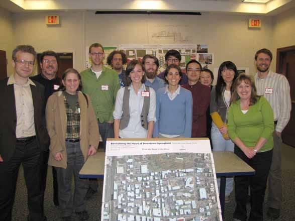
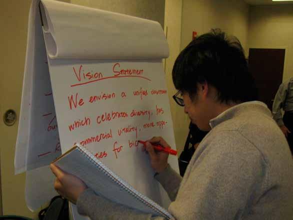
3 UMass Amherst Design Center in Springfield, MA The Springfield Initiative: UMass plan to help revitalize the City of Springfield Support from: Graduate Dean John Mullin, LARP, Chair Elizabeth Brabec UMass Extension, Nancy Garrabrants Major Collaborators 1.University of Massachusetts Department of Landscape Architecture and Regional Planning Art and Architecture Program Department of Natural Resources and Conservation UMass Extension 2.City of Springfield Office of Mayor Department of Planning and Economic Development
4

5 2. Greenways in Springfield MA UMass Amherst Springfield Proposed 740 mile Bay State Greenway Network, Mass Highway, 2008


6


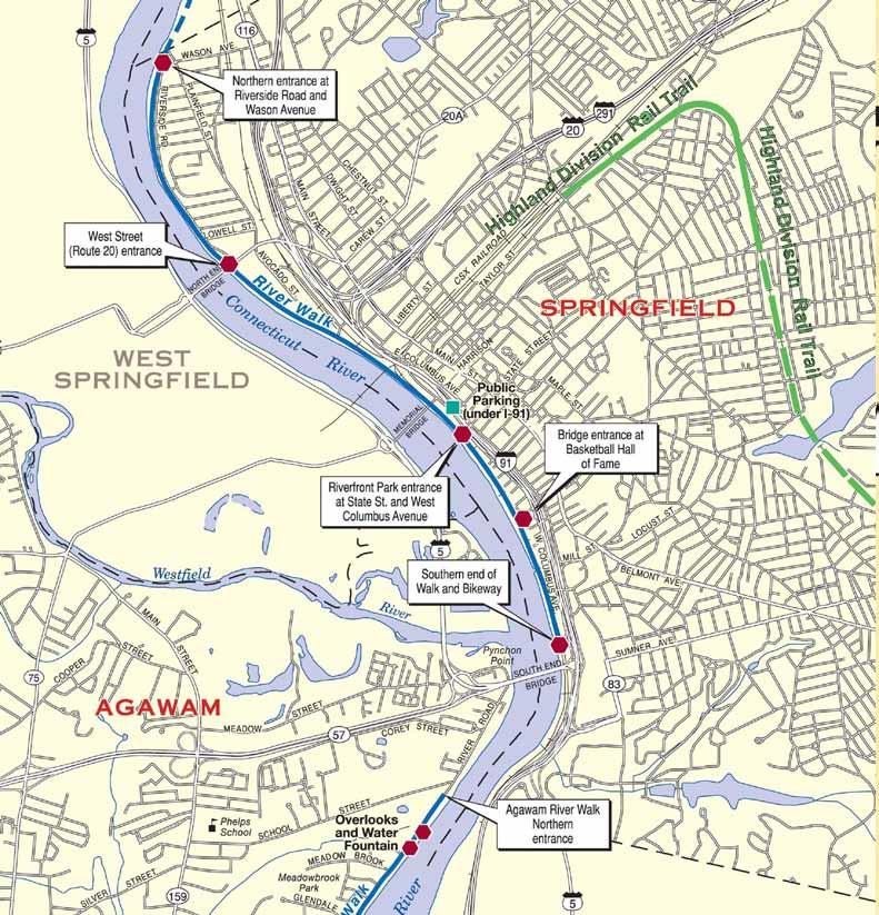
7 Proposed Greenway and Green Streets Network, Sleegers and Lynch, 2008 Abandoned Highland Division Rail Line, at Mason Square, 2008
8 Various Stakeholders involved and interested in Greenway Planning in Springfield: Department of Planning and Economic Development Department of Parks and Recreation Department of Public Health and Human Services (HHS) Chamber of Commerce in Springfield, Massachusetts Public Health Sector, Groups supporting active recreation Partners for a healthier community, Inc. (PHC) Neighborhood councils, Local politicians Advocate groups, Springfield BID Health Industry (e.g. Baystate Health) Police Department DPW Rails to Trails Conservancy National Park Service, Massachusetts Springfield Health Coalition Mason Square Neighborhood Health Center, Mason Square Senior Center, Mason Square Weed and Seed Coalition Springfield Partners for Community Action/Total Health. Local Colleges Pioneer Valley Planning Commission (PVPC) Railroad representatives Residents/stakeholders from other urban communities that can speak to the benefits of greenways (particularly residential abutters) Abutters of proposed greenways in Springfield Secretary of Transportation Institutions and people with access to funding e.g. MASS Mutual River Walk activists Mass Highway Survey Sleegers, DiPasquale, 2010

9 3. Design Centers: Services and Organizational Structure
10
11
12 Organizational models for the UMass Amherst Design Center University Based Firm Pro: Con: Organizes recent Springfield-based design and planning work more systematically and professionally than university studios Impact on the physical environment of the city charges money than University design studios do Studio Pro: Con: Focus on clearly defined topics and effective short-term efforts (like greenway implementation) Integration into bigger organizational schemes necessary Does not reflect the richness of UMass research and already existing initiatives
13


14 University of Arkansas Community Design Center Warren Greenway
15


16 The Train Avenue Greenway Plan CLEVELAND, OHIO Stockyard Redevelopment Organization


17 W. 25TH W. 30TH Kent State University Cleveland Urban Design Collaborative Train Avenue Greenway Plan TRAIN AVENUE GREENWAY SIMULATION IMAGES TRAIN AVENUE GREENWAY TYPICAL SECTION R.O.W. R.O.W. TRAIN AVENUE GREENWAY MASTERPLAN Zone Rec Center 10 All Purpose Trail 5 Tree Lawn 30 Typical Road Width 15 Greening 60 Typical Right of Way Proposed Towpath Trail Connectors Barbara Booker Elementary School W. 65TH WALWORTH AVE. W. 53RD Urban Community School W. 44TH Orchard School of Science Elementary Greenwood Park Dunbar Elementary COLUMBUS RD. LORAIN/CARNEGIE Abbey Park ABBEY AVE. TRAIN AVE. UNIVERSITY Clark Recreation Center Clark Elementary School W. 51ST Train Park W. 48TH CLARK AVE. HOWLETT AVE. TRAIN AVE. W. 43RD Cemetery W. 41ST RICHNER AVE. Roberto Clemente Field FULTON RD. VEGA AVE. Monroe Cemetery BARBER AVE. RTA Station TRAIN AVE. WILLEY AVE. Lincoln Park OLA/St Joseph Center Elementary Walton Elementary Scranton Elementary School Stockyard Redevelopment Organization i TRAIN AVENUE GREENWAY PLAN


18 Public Meeting Train Stations and public conclusions TRAIL PLANNING - TRAIL ALTERNATIVES & CONNECTIONS TO THE LAKEFRONT & BIG CREEK INFRASTRUCTURE- TRAFFIC PLANNING & SAFETY GREENSPACE DEVELOPMENT- GREENING/REGENERATION & GREEN INFRASTRUCTURE FUTURE LAND USE- MANUFACTURING, COMMERCIAL & RESIDENTIAL OPPORTUNITIES GREENWAY ENHANCEMENTS PUBLIC ART, WAYFINDING, HISTORIC HERITAGE & NEIGHBORHOOD CONNECTIONS CONCLUSION The Public was concerned about issues of maintenance and safety as well as had suggestions of signage and crosswalks. CONCLUSION The Public had an interest in learning more about Green Infrastructure and had unanimous support for greening & regeneration. The Public suggested investigating naturalized bioswales, permeable paving and raingardens. CONCLUSION There was interest in preserving and redeveloping the historical buildings and looking at the corridor s sense of history as a major thematic element to attract new residents, businesses & trail users. CONCLUSION The Public had an unanimous vote in favor of Option 3: the All-Purpose Trail next to the road. CONCLUSION The public was in support of signage and highlighting the history of the area. The public was intrigued with the idea of a ghost footprint to represent the mill pond & Walworth Run.


19 Kent State University Cleveland Urban Design Collaborative Train Avenue Greenway Plan 58 DETAILED PLAN OF CENTRAL SECTION OF TRAIN AVENUE GREENWAY BEFORE & AFTER OF CENTRAL SECTION OF TRAIN AVENUE GREENWAY DETAILED PLAN OF WILLEY/TRAIN INTERSECTION AT EAST SIDE OF GREENWAY BEFORE & AFTER OF EAST SIDE OF TRAIN AVENUE GREENWAY
20


21 Chatanooga Urban Design Studio Tennessee Riverpark Master Plan


22 Chatanooga Urban Design Studio Tennessee Riverpark Master Plan
23
24 5. Conclusions for the Mission and Work of the UMass Amherst Design Center
25

26
UMass Amherst Design Center in Springfield
 UMass Amherst Design Center in Springfield Projects supported through the UMass Amherst Design Center in Springfield (updated 12/10/13, Michael DiPasquale and Frank Sleegers) The majority of the studios
CHAPTER VIII Implementation
 CHAPTER VIII Implementation VIII. Implementation The vision for the Marlboro Pike Corridor will require that a variety of participants work together to make it a reality. The following action steps outline
Potential Green Infrastructure Strategies May 6, 2015 Workshop
 Potential Green Infrastructure Strategies May 6, 2015 Workshop Background The City of Cortland is developing the Tioughnioga Urban Headwaters Green Infrastructure Action Plan with funding from the National
CHAPTER 7: Transportation, Mobility and Circulation
 AGLE AREA COMMUNITY Plan CHAPTER 7 CHAPTER 7: Transportation, Mobility and Circulation Transportation, Mobility and Circulation The purpose of the Transportation, Mobility and Circulation Chapter is to
Sherri Ferguson. President/CEO Portland Chamber of Commerce. Tennessee Certified Economic Developer Capstone Project
 Sherri Ferguson President/CEO Portland Chamber of Commerce Tennessee Certified Economic Developer Capstone Project Strategic Plan Development for the North Gateway of Portland, Tennessee The New Gateway
HOT SPRINGS COMPREHENSIVE PLAN OUTLINE
 HOT SPRINGS COMPREHENSIVE PLAN OUTLINE 7/28/2015 Draft outline - Hot Springs Comprehensive Plan Draft outline of topics to be discussed at public hearings and in planning sessions. Order and topics and
October 25 Downtown Partnership and Action Plan Workshop Record of Group Table Results
 October 25 Downtown Partnership and Action Plan Workshop Record of Group Table Results During the October 25 workshop, participants were asked to rank their top priorities for the Downtown Action Plan.
TOWN BRANCH COMMONS & VINE STREET MOBILITY IMPROVEMENTS
 TOWN BRANCH COMMONS & VINE STREET MOBILITY IMPROVEMENTS CONTACT: Jeff Fugate, President O: 859-367-4972 F: 859-425-2292 JFugate@LexingtonDDA.com www.lexingtondda.com TOWN BRANCH COMMONS & VINE STREET MOBILITY
9 North Downtown Master Plan & Saskatchewan Polytechnic
 9 North Downtown Master Plan & Saskatchewan Polytechnic Overview The area south of 33 rd Street (across from Kelsey-Woodlawn) will begin to see significant changes in the future. The North Downtown Master
Volume 2: Implementation Plan
 Volume 2: Implementation Plan February 25 th 2002 Implementation Introduction This document outlines the steps that should be taken to implement the Washington Heights Neighborhood Plan. The City Council
Downtown Dubuque...it s a great time.
 Downtown Dubuque...it s a great time. Your timing could not be better to invest in Downtown. With hundreds of millions in public and private investment occurring on the City s downtown waterfront, millions
Public may provide comments on the GDP within the next two weeks (December 24)
") 25/70 General Development Plan (GDP) Public Meeting Wednesday, December 10, 2014 6:00 8:00 P.M. District 1 Police Station Community Room 1311 W 46th Ave, Denver, CO 80211 Council Woman Montero: This particular
25/70 General Development Plan (GDP) Public Meeting Wednesday, December 10, 2014 6:00 8:00 P.M. District 1 Police Station Community Room 1311 W 46th Ave, Denver, CO 80211 Council Woman Montero: This particular
NORTH HARBOR INITIATIVE
 Indiana Harbor, East Chicago, Indiana NORTH HARBOR INITIATIVE Community Reinvestment Public Shoreline Connection Strong Leadership The City of East Chicago and are leading the revitalization of Indiana
Illustration of Eastlake Farmer s Cooperative Grain Elevator. Chapter 5: implementation 5-1
 Illustration of Eastlake Farmer s Cooperative Grain Elevator Chapter 5: implementation 5-1 chapter 5: implementation Introduction The Eastlake Subarea Plan includes a wide range of recommendations intended
Planning Board Briefing
 Planning Board Briefing Why Now? The Sector Plan Implementation Chapter States: Before Stage 1 begins, the following must occur: Approval of the Sectional Map Amendment. Approval of the Greater Lyttonsville
Project Goal. RRRC Living Towns Planning Workshp. Town of Halifax Revitalization Project. Dynamic Planning & Management Duo: July 12, 2006
 Project Goal Town of Halifax Revitalization Project RRRC Living Towns Planning Workshp July 12, 2006 Town of Halifax Halifax County *** Revitalization Project Goal*** To create Economic Opportunity and
LAND USE PLAN 7. Housing
 21 LAND USE PLAN While the land uses that have historically dominated the Corridor itself have been industrial/commercial, the Master Plan proposes a shift to mixed-use redevelopment, complimented by a
Green Infrastructure The Indianapolis Greenways Connection
 Green Infrastructure The Indianapolis Greenways Connection Fewer things in the transportation industry today make better since than combining the needs for pedestrian and bike trails with the need to locate,
Pittsfield Action Plan (West Branch of the Housatonic River)
") An initiative of the Massachusetts Executive Office of Energy and Environmental Affairs in partnership with the City of Pittsfield Pittsfield Action Plan (West Branch of the Housatonic River) The spring
An initiative of the Massachusetts Executive Office of Energy and Environmental Affairs in partnership with the City of Pittsfield Pittsfield Action Plan (West Branch of the Housatonic River) The spring
Taking forward the All London Green Grid
 Taking forward the All London Green Grid Foreword Earlier this year, the Mayor published the All London Green Grid Supplementary Planning Guidance to the London Plan which set the vision, and framework,
The DCR Neponset River Trail Central Avenue to Mattapan Square
 The DCR Neponset River Trail Central Avenue to Mattapan Square Photo Public Meeting Tuesday, August 30, 2011 7:30 pm 9:00 pm Foley Senior Residences Dining Room 249 River Street, Mattapan DCR MISSION STATEMENT
LANDSCAPE ARCHITECTURE PORTFOLIO
 LANDSCAPE ARCHITECTURE PORTFOLIO AIDA HERNÁNDEZ ADDRESS: 225 LORRAINE AVE. APT. 3 SYRACUSE, NY 13210 PHONE: 315. 921. 3688 EMAIL: AIDAMECHE.HERNANDEZ@GMAIL.COM table of contents 3 4 6 7 Garden Design Construction
CLARK AVENUE. Corridor Plan. DRAFT February 27, 2015
 CLARK AVENUE Corridor Plan DRAFT February 27, 2015 acknowledgements PROJECT SPONSORS City of Cleveland Tremont West Development Corporation TECHNICAL ADVISORY COMMITTEE Bike Cleveland Canalway Partners
Examples of Asset Based Approaches to Development. Economic and Community Development Suffield, CT
 Examples of Asset Based Approaches to Development Presented by: Patrick McMahon, Director of Economic and Community Development Suffield, CT Neighborhood Commercial Development Wilson, CT Issues Elevated
Regional Engagement Sub-Regional Forum Monroe County
 Regional Engagement Sub-Regional Forum Monroe County Brownfields Eastman Business Park South (2014) JMT Properties Site- Brockport (2012) Barthelmes Manufacturing Site- Rochester (2013) Economic Distress
Long Lost Allies? Walking Advocates & Business District Organizations. Matt Kazinka Lake Street Council. Shaina Brassard Seward Redesign
 Long Lost Allies? Walking Advocates & Business District Organizations Shaina Brassard Seward Redesign Rob Hanson West Broadway Business and Area Coalition Matt Kazinka Lake Street Council Jamie Schumacher
Alexandria Recreation & Education Program (AREP) April 2014
 April 2014") Alexandria Recreation & Education Program (AREP) April 2014 PROPOSITION (AREP RECREATION MILLAGE) VOTE: May 3, 2014! L14-095 - Rapides Parish, City of Alexandria - 6 mills tax, 20 years, 2014-2033, acquiring,
Alexandria Recreation & Education Program (AREP) April 2014 PROPOSITION (AREP RECREATION MILLAGE) VOTE: May 3, 2014! L14-095 - Rapides Parish, City of Alexandria - 6 mills tax, 20 years, 2014-2033, acquiring,
CITY OF INVER GROVE HEIGHTS A G E N D A CITY COUNCIL WORK SESSION June 3, :00 PM INVER GROVE HEIGHTS CITY HALL COUNCIL CHAMBERS
 CITY OF INVER GROVE HEIGHTS A G E N D A CITY COUNCIL WORK SESSION June 3, 2013 6:00 PM INVER GROVE HEIGHTS CITY HALL COUNCIL CHAMBERS 1. CALL TO ORDER Mayor Tourville 2. RENTAL REGULATIONS 3. FRONT YARD
Cleveland Innerbelt Bridge / Central Viaduct City Planning Commission November 6, 2009
 Cleveland Innerbelt Bridge / Central Viaduct City Planning Commission November 6, 2009 Process for Aesthetics Subcommittee June 25, 2009 Kick off Meeting June 26, 2009 Gateway and Tremont Focus Groups
Capital Projects in and near Odenton Town Center
 Capital Projects in and near Odenton Town Center Map ID Anne Arundel County Department of Public Works This project provides for the design, right of way acquisition, and construction of approximately
City of Meriden Harbor Brook Flood Control Project Overview
 City of Meriden Harbor Brook Flood Control Project Overview Updated August 2013 OVERVIEW The center of Meriden, including the HUB site is the low point of the town which is ringed by basalt ridges. Running
Introduction. Midtown Loop. This project s purpose is to envision and design an urban greenway known as Midtown Loop for the Detroit Midtown area.
 Introduction This project s purpose is to envision and design an urban greenway known as for the Detroit Midtown area. Midtown includes the region s cultural core, historic and new neighborhoods, Wayne
Joint Public Hearing. Preliminary Subregion 5 Master Plan and Proposed Sectional Map Amendment
 Preliminary Subregion 5 Master Plan and Proposed Sectional Map Amendment Joint Public Hearing April 11, 2013 Council Hearing Room Upper Marlboro 7:00 pm His Lordship s Kindness (Clinton) Presentation Overview
Costal Sustainability and Green Streets, Mobile, Alabama
 Costal Sustainability and Green Streets, Mobile, Alabama A Green Infrastructure Plan for Mobile, Alabama Charlene LeBleu, AICP, ASLA Auburn University Landscape Architecture School of Architecture College
The Auburn Plan Designing the Future of Auburn February 28, 2005
 The Auburn Plan Designing the Future of Auburn February 28, 2005 Block-by-Block Bicycle Tour Aerial survey Focus Group Meetings September 7 and 8 Design Workshops October 11, 14, and 21 Revitalization
From Partnership to Reality
 From Partnership to Reality New Partners for Smart Growth February 4, 2011 What is Sustainable (human) Development? It is development that meets the needs of the present without compromising the ability
5. Implementation. Challenges
 5. Implementation The Campus plan builds on the work that has been done so far by the Campus Concept Committee comprised of representatives from the North End Outreach Network (NEON), the New North Citizens
DOMINION BOULEVARD CORRIDOR STUDY AND ECONOMIC DEVELOPMENT STRATEGIC PLAN A MODEL FOR CHESAPEAKE S FUTURE
 DOMINION BOULEVARD CORRIDOR STUDY AND ECONOMIC DEVELOPMENT STRATEGIC PLAN A MODEL FOR CHESAPEAKE S FUTURE Overview I. Draft Plan Process II. Draft Plan Overview a. Market Analysis b. Master Land Use Plan
Previous Stakeholder Meetings
 Titusville Tomorrow Previous Stakeholder Meetings Workshop 1 SWOT CVS Workshop 2 SWOT and CVS Results Value of Place Based Design 3 Table Top Designs The Waterfront The Gateways The Downtown Key Points
Planning Districts INTRODUCTION
 INTRODUCTION To facilitate detailed examination of development prospects for all areas of the community, Delano has been divided into 14 planning districts. The location of these planning districts is
Atlanta BeltLine Subarea 3 Master Plan Update
 Atlanta BeltLine Subarea 3 Master Plan Update April 14, 2018 Workshop Meeting 1 22 miles, connecting 45 neighborhoods 22 MILES of transit 46 MILES of streetscapes and complete streets 33 MILES of urban
Village Center Zoning. Town of Sutton, MA June 15, 2016
 Village Center Zoning Town of Sutton, MA June 15, 2016 Village Center Zoning Project Phase 1 was the development of the new Model Bylaw Phase 2 sought communities to work with to update existing or create
Harlem Avenue Corridor Plan: Corridor Planning Across Municipal Boundaries
 Harlem Avenue Corridor Plan: Corridor Planning Across Municipal Boundaries Heather Tabbert, Manager, Local Planning and Programs Division Regional Transportation Authority (RTA) Jen McNeil Dhadwal, Principal
McDaniel Creek Master Plan
 McDaniel Creek Master Plan UNIVERSITY AVE., PITTSBURGH NEIGHBORHOOD AND THE MCDANIEL CREEK WATERSHED 60 ANSLEY MALL AND THE CLEAR CREEK GREENWAY 61 INTRODUCTION The BeltLine Subarea 6 site lies within
PLAN ELEMENTS WORKSHOP. April 5, 2016
 PLAN ELEMENTS WORKSHOP April 5, 2016 needs more housing. But there is no one-size fits-all solution. Every neighborhood has its own character. In some places, density is not only appropriate it is badly
Hockessin Community Redevelopment Plan
 Hockessin Community Redevelopment Plan 3.1 Introduction The Community Redevelopment Plan for the Village of Hockessin is the result of the people s vision for a distinct village center that serves as the
ROME WATERFRONT VILLAGE PROJECT NARRATIVE January 25, 2018
 January 25, 2018 The Rome Waterfront Village project is intended to foster the revitalization of the area between South James Street and Erie Boulevard north of the Erie Canal as well as improve public
CHAPTER 8. Mrs. Zimman s Class - Central Elementary
 SUSTAINABILITY CHAPTER 8 Mrs. Zimman s Class - Central Elementary 8.1 OVERVIEW Green infrastructure also known as low impact development (LID) and environmental or sustainable site design is an environmentally
Town of Cornelius Bond Update August, 2017
 Town of Cornelius Bond Update August, 2017 Referendum Results Roads, Intersections, & Sidewalks ($11.15 mil) Pass rate 81.38% in favor Parks and Recreation ($5.25 mil) Pass rate 72.09% in favor Town Center
John M. Fleming Managing Director, Planning and City Planner. Old East Village Dundas Street Corridor Secondary Plan Draft Terms of Reference
 Report to Planning and Environment Committee To: From: Subject: Chair and Members Planning & Environment Committee John M. Fleming Managing Director, Planning and City Planner Old East Village Dundas Street
Capital Projects impacting Odenton Town Center
 Capital Projects impacting Odenton Town Center 1 2 E549700 W801600/ W801602 Anne Arundel County Department of Public Works Manor View Elementary School Transmission Main - MD 32 @ Meade Phase 2 $34,399,000
Highway 12 Sibley Avenue Reconstruction. Project Overview and Progress To Date Litchfield City Council April 17, 2017
 Highway 12 Sibley Avenue Reconstruction Project Overview and Progress To Date Litchfield City Council April 17, 2017 Agenda Item Topic 1) Project Purpose and Need 2) Key Recommendations from Study 3) Preliminary
TOWN COUNCIL / PLANNING COMMISSION
 Workshop #3 TOWN COUNCIL / PLANNING COMMISSION January 20, 2011 Consultant Team In Attendance Tonight BMS Design Group Nevada City and San Francisco Michael Smiley, AICP, ASLA Partner-in-Charge Nancy L.
Lower South Street/Louisa Street Charrette Final Presentation. September 22, 2009
 Lower South Street/Louisa Street Charrette Final Presentation September 22, 2009 Recap Mayor and Council called for a Charrette to engage the public on creating a vision for the Lower South Street area.
MS4 PROGRAM COST SAVINGS THROUGH COMMUNITY PARTNERSHIPS
 MS4 PROGRAM COST SAVINGS THROUGH COMMUNITY PARTNERSHIPS NICHOLAS ERICKSON, PE CITY OF FITCHBURG, MA KATHRYN EDWARDS, PE ARCADIS U.S., INC. Maine Stormwater Conference October 23, 2017 Agenda Introduction
Greening America s Cities: A Capital Idea
 Greening America s Cities: A Capital Idea Presenters Clark Wilson, EPA Mayor Mark Stodola, Little Rock, AR Mayor Harvey Johnson, Jackson, MS Caran Curry, Little Rock, AR Clare Watson, Montgomery, AL Program
SPRINGFIELD, MA Technical Assistance Panel (TAP)
") SPRINGFIELD, MA Technical Assistance Panel (TAP) ULI the Urban Land Institute Mission To provide leadership in the responsible use of land and in creating and sustaining thriving communities worldwide.
SPRINGFIELD, MA Technical Assistance Panel (TAP) ULI the Urban Land Institute Mission To provide leadership in the responsible use of land and in creating and sustaining thriving communities worldwide.
Honorable Mayor and Members of the City Council. Submitted by: Eric Angstadt, Director, Planning and Development
 Office of the City Manager ACTION CALENDAR January 29, 2013 To: From: Honorable Mayor and Members of the City Council Christine Daniel, City Manager Submitted by: Eric Angstadt, Director, Planning and
San Francisco Bay Pilot: Sausal Creek Community Leader Charrette May 11, 2016 Marcus Griswold
 San Francisco Bay Pilot: Sausal Creek Community Leader Charrette May 11, 2016 Marcus Griswold 1 Overview Project Overview Watershed Context Assets and Challenges Opportunities Green Streets Creek Access
PIQUA OHIO PLACEMAKING INITIATIVE
 PIQUA OHIO PLACEMAKING INITIATIVE A HANDBOOK to understanding the Placemaking Initiative for Piqua, Ohio June 15 2016 GAMBLE ASSOCIATES urban design BOOKER DESIGN COLLABORATIVE landscape architecture CITYVISIONS
GOCO Grants Awarded to Projects in Arapahoe County through June 2015
 Grant Type Open Space Fiscal Year Applicant Project Title Grant Amount 2015 City of Aurora Acres Protected Triple Creek Greenway Corridor Phase 3 $2,050,000.00 0 Planning 2015 Arapahoe County High Line
Kensington Center. Public Meeting # Transit-Oriented Development, Town of Berlin, CT
 Kensington Center Public Meeting #1 10.27.16 Transit-Oriented Development, Town of Berlin, CT CivicMoxie 2016 What is Transit-Oriented Development Definition: Transit-Oriented Development (TOD) = is an
UNIVERSITY CITY AREA PLAN. Volume Two: Implementation Plan
 UNIVERSITY CITY AREA PLAN Volume Two: Implementation Plan Transforming the University City MSD into the vibrant, people-oriented place envisioned in the University City Plan will occur incrementally through
LAUNCH LORAIN Charrette. Lorain Avenue/South of Lorain Neighborhood
 LAUNCH LORAIN Charrette Lorain Avenue/South of Lorain Neighborhood LAUNCH LORAIN Charrette Lorain Avenue/South of Lorain Neighborhood The Launch Lorain Charrette was made possible with the generous support
Point A Point B Point C Point D. City of Hapeville Public Meeting July 25, 2017
 City of Hapeville Public Meeting July 25, 2017 Fulton County Transit Master Plan Overview Following last year s ¾-cent TSPLOST effort, the Mayors of the 14 Cities outside of Atlanta and the Fulton County
TRANSPORTATION PROJECTS
 TRANSPORTATION PROJECTS 40 BUFFALO S LWRP PROPOSED PROJECTS T1. Niagara Street/Great Lakes Seaway Trail Streetscape Project City of Buffalo Department of Public Works Niagara Street from Niagara Square
Rich Valley Greenway Master Plan. Central Greenway Connectivity Study
 Rich Valley Greenway Master Plan Central Greenway Connectivity Study Dakota County Planning Commission February, 2017 Rich Valley Greenway Master Plan Dakota County Greenway Vision Establish a County-wide
Program Schedule, Budget and Scope
 Sewer System Improvement Program + Program Schedule, Budget and Scope Mission & Valencia Green Gateway Presentation: July 9, 2013 San Francisco Public Utilities Commission Mission & Valencia Green Gateway
Preface. Erie. Scranton. Allentown. Pittsburgh. Harrisburg. Philadelphia
 The Southern Alleghenies Region The Southern Alleghenies Region spans the Laurel Highlands and Allegheny Front in the west across the Appalachians to the east. It is comprised of Blair, Bedford, Cambria,
M E M O R A N D U M. DATE: July 19, Patrick D. O Keeffe, City Manager. Economic Development & Housing
 M E M O R A N D U M DATE: July 19, 2011 TO: FROM: Patrick D. O Keeffe, City Manager Economic Development & Housing SUBJECT: Resolution of the City Council of the City of Emeryville Approving the Application
MAYFIELD VILLAGE GREENWAY TRAIL
 1 Shared use 10 wide asphalt all purpose trail Includes 60 ft. steel truss bridge, 549 ft. of boardwalk, three underpasses Connects Village center to Library, Metroparks, and Village recreational areas
Corridor Vision. 1Pursue Minnehaha-Hiawatha Community Works Project. Mission of Hennepin County Community Works Program
 1Pursue Minnehaha-Hiawatha Community Works Project Minnehaha-Hiawatha Community Works is a project within the Hennepin Community Works (HCW) program. The mission of the HCW program is to enhance how the
Statewide Greenways Vision
 Greenways Vision The formation of a greenways vision is based on a thorough analysis of the current state of recreation and open space in a region and the existing pressures that threaten it. Lehigh and
Bethesda Downtown Plan
 Bethesda Downtown Plan Planning Board Update Connecticut Avenue Location Economic Sustainability Social Environmental Scope Coming Soon! Team Listening, Twitter Outreach We Are Here Engagement Challenge
Presenting a Vision for Thread Lake
 Presenting a Vision for Thread Lake FEBRUARY 20, 2014 SPECIAL THANKS TO: International Academy of Flint Flint River Watershed Coalition South Saginaw Business and Resident Association South Side Neighborhood
NORTH CLAYMONT AREA MASTER PLAN COMMUNITY WORKSHOP #1 FEBRUARY 3, 2016
 NORTH CLAYMONT AREA MASTER PLAN COMMUNITY WORKSHOP #1 FEBRUARY 3, 2016 1. Introduction To the team and to the Plan Planning Partners The Claymont Community WILMAPCO New Castle County Claymont Renaissance
TECHNICAL ASSISTANCE PANEL. Graniteville TAP: Developing a Community Vision
 TECHNICAL ASSISTANCE PANEL SPONSORED BY: Graniteville TAP: Developing a Community Vision Graniteville Community Development Improvement Corporation Mission To provide leadership in the responsible use
The transportation system in a community is an
 7 TRANSPORTATION The transportation system in a community is an important factor contributing to the quality of life of the residents. Without a sound transportation system to bring both goods and patrons
CONTEXT: the Highway, the River + the Railroads run through us.
 CONTEXT: the Highway, the River + the Railroads run through us. I-25 36 In the past they have divided us, now we have an opportunity to unite us. I-76 I-270 I-76 CSU I-25 LEGEND Cut + Cover River North
APPENDIX 4 NEWBURY TOWNSHIP TOWN CENTER MASTER PLAN
 APPENDIX 4 NEWBURY TOWNSHIP TOWN CENTER MASTER PLAN Prepared by the Urban Design Center of Northeast Ohio September, 2008 Newbury Township Land Use Plan A4-1 INDEX Page No. 1 Newbury Township Town Center
Director of Development and External Relations
 Director of Development and External Relations Emerald Necklace Conservancy Boston, MA Summer/Fall 2017 Tracy Marshall SENIOR VICE PRESIDENT OF EXECUTIVE SEARCH SERVICES Development Guild DDI 617.277.2112
Town of Avon Village Center. A New Village Center for Avon October, 2015
 Town of Avon Village Center A New Village Center for Avon October, 2015 A busy Avon Center approx. 1940 The Avon Town Center Study: In 2004 the Planning and Zoning Commission (PZC) undertook the Avon
Preserving Our Past. Securing Our Future.
 Heritage Woods/Traffic Montrose West Intersection Springside Dr./S.R. 18Intersection Flight Memorial Dr./ S.R. 18Intersection Red Roof Inn High Density Development Ridgewood/ Cleve-Mass Intersection Ridgewood/
Oconee Rivers Greenway Project. TSPLOST 2018 Project # 5 Project Concept Sub-projects 7, 8, 9, 10, & 11. Mayor & Commission Work Session
 Oconee Rivers Greenway Project Project # 5 Project Concept Sub-projects 7, 8, 9, 10, & 11 Mayor & Commission Work Session February 13, 2018 North Oconee River Greenway 1 Project # 05 - Oconee Rivers Greenway
Riverwalk Dreams compiled by Thomas P. Healy November 16, 2017
 Riverwalk Dreams compiled by Thomas P. Healy November 16, 2017 1986 Ripple Village Plan: A neighborhood plan developed by the City of Indianapolis Department of Metropolitan Development s Division of Planning
2010 Tentative Enhancement Program Allocations (FY11)
") Bristol 10011 Buchanan County Buchanan County project cost $1,190,332 Bull Creek Trail - construction of a pedestrian/bicycle trail along abandoned request amount $240,323 railroad right of way. allocation
Bristol 10011 Buchanan County Buchanan County project cost $1,190,332 Bull Creek Trail - construction of a pedestrian/bicycle trail along abandoned request amount $240,323 railroad right of way. allocation
Elliot Park 4. Neighborhood Master Plan. The Master Plan
 Elliot Park 4 Neighborhood Master Plan August 2002 Why Master Plan? Construction cranes signal new growth downtown as the backdrop to this smaller scale, quiet neighborhood. Do nothing or plan for the
38 Queen s University Campus Master Plan Part 1
 38 Queen s University Campus Master Plan Part 1 46 The Campus at the City Scale Chapter 4 The Campus at the City Scale 39 Queen s is an urban University centrally located in Kingston. Decisions made by
Dyersville Downtown Plan. Open House October 24, 2017
 Dyersville Downtown Plan Open House October 24, 2017 What is a Comprehensive Plan? - Vision - Guidance for decisions - Basis for regulations What is a Downtown Plan? - Understand priorities - Identify
THREE-YEAR CAPITAL IMPROVEMENT PLAN FY
 THREE-YEAR CAPITAL IMPROVEMENT PLAN FY2016 2018 Annual CIP Development Process Public Works & Engineering Divisions Prepare List of Capital Needs and Recommended Deferred Maintenance Public Works & Engineering
Community Engagement Committee Meeting #1 December 10, :30pm-8:30pm
 Community Engagement Committee Meeting #1 December 10, 2014 6:30pm-8:30pm Welcome and Introductions Dana Murdoch Minneapolis Park and Recreation Board Project Manager Ryan French Walker Art Center Director
RFP REQUEST FOR PROPOSALS CITY OF PORTSMOUTH, NH. DESIGN ENGINEERING SERVICES North Mill Pond Trail and Greenway
 RFP 61-18 REQUEST FOR PROPOSALS CITY OF PORTSMOUTH, NH DESIGN ENGINEERING SERVICES North Mill Pond Trail and Greenway Sealed Requests for Proposals, plainly marked RFP 61-18 Design Engineering Services
REGIONAL ACTIVITY CENTER
 DRAFT REGIONAL ACTIVITY CENTER 70 EAST BENCH MASTER PLAN DRAFT 06 Introduction The East Bench Regional Activity center is comprised of large educational, research, medical, and employment centers. These
Committee Meeting: Downtown Today & Concept Refinement September 11, 2017
 Committee Meeting: Downtown Today & Concept Refinement September 11, 2017 AGENDA 1. Brief Input Update 2. Comprehensive Plan Principles 3. Downtown Today 4. Concept Updates 5. Future Schedule What is a
METROPOLITAN COUNCIL 390 North Robert Street, St. Paul, MN Phone (651) ; TDD (651)
 ; TDD (651)") DATE: December 20, 2011 METROPOLITAN COUNCIL 390 North Robert Street, St. Paul, MN 55101 Phone (651) 602-1000; TDD (651) 291-0904 TO: Metropolitan Parks and Open Space Commission FROM: Tori Dupre, Senior
DATE: December 20, 2011 METROPOLITAN COUNCIL 390 North Robert Street, St. Paul, MN 55101 Phone (651) 602-1000; TDD (651) 291-0904 TO: Metropolitan Parks and Open Space Commission FROM: Tori Dupre, Senior
Welcome. Comprehensive Plan & Transportation Plan Open House November 7, 2012
 Welcome Comprehensive Plan & Transportation Plan Open House November 7, 2012 Agenda Proposed future land use plan Comprehensive Plan strategies Traffic forecasts Future traffic operations Possible future
COMMERCIAL CORRIDOR PLANNING SW 9 TH STREET CORRIDOR NE CORRIDOR MARKET DISTRICT KEO WAY CORRIDOR
 COMMERCIAL CORRIDOR PLANNING SW 9 TH STREET CORRIDOR NE CORRIDOR MARKET DISTRICT KEO WAY CORRIDOR Council Workshop July 29, 2013 SW 9 th Street Corridor Plan What is this initiative? A PUBLIC-PRIVATE pilot-partnership
The Economic Benefits of Greenspace OHIO LAND BANK CONFERENCE SEPTEMBER 11, 2014 JAMES KASTELIC, PROGRAM DIRECTOR, TRUST FOR PUBLIC LAND
 The Economic Benefits of Greenspace OHIO LAND BANK CONFERENCE SEPTEMBER 11, 2014 JAMES KASTELIC, PROGRAM DIRECTOR, TRUST FOR PUBLIC LAND Land Conservation Makes Good Economic Sense Every $1 invested in
PUBLIC SPACES MASTER PLAN UPDATE (POPS) Joint Facilities Advisory Commission (JFAC) November 28, 2018
 Joint Facilities Advisory Commission (JFAC) November 28, 2018") PUBLIC SPACES MASTER PLAN UPDATE (POPS) Joint Facilities Advisory Commission (JFAC) November 28, 2018 1 AGENDA POPS Planning Context Timeline Public Input Final POPS Draft Next Steps 2 PLANNING CONTEXT
PUBLIC SPACES MASTER PLAN UPDATE (POPS) Joint Facilities Advisory Commission (JFAC) November 28, 2018 1 AGENDA POPS Planning Context Timeline Public Input Final POPS Draft Next Steps 2 PLANNING CONTEXT
Mississippi Drive Corridor Revitalization. A DestinationTransportation Project...
 Mississippi Drive Corridor Revitalization A DestinationTransportation Project... Mississippi Drive Corridor Revitalization Welcome! Tonight s Agenda: Further define the Scope of the Project Discuss the