Executive Committee Meeting #4/10
|
|
|
- Miles Hoover
- 5 years ago
- Views:
Transcription
1 Executive Committee Meeting #4/10 Chair: Vice Chair: Members: Gerri Lynn O'Connor Maria Augimeri David Barrow Gay Cowbourne Glenn De Baeremaeker Suzan Hall Jack Heath Colleen Jordan Ron Moeser Anthony Perruzza Maja Prentice Richard Whitehead June 4, :30 A.M. VICTORIA ROOM, BLACK CREEK PIONEER VILLAGE EX1. MINUTES OF MEETING #3/10, HELD ON MAY 7, 2010 (Minutes Summary Enclosed Herewith on PINK) AGENDA Pages EX2. EX3. EX4. EX5. BUSINESS ARISING FROM THE MINUTES DISCLOSURE OF PECUNIARY INTEREST AND THE GENERAL NATURE THEREOF DELEGATIONS PRESENTATIONS EX5.1 A presentation by Brian Buchanan, Senior Engineer Technical Services, and Pat Chessie, Manager, Sewer Asset Planning, City of Toronto, in regard to item EX9.1 - Coxwell Sanitary Trunk Sewer Emergency Reponse Plan. EX6. CORRESPONDENCE 1
2 EX7. SECTION I - ITEMS FOR AUTHORITY ACTION CONFIDENTIAL - ITEM EX7.1 - As it pertains to on-going property negotiations EX7.1 GREENLANDS ACQUISITION PROJECT FOR Flood Plain and Conservation Component, Humber River Watershed, Regional Municipality of Peel Hi-Lands of Bolton Corp. CFN EX7.2 GREENLANDS ACQUISITION PROJECT FOR Flood Plain and Conservation Component, Duffins Creek Watershed Delco Homes Inc. CFN EX7.3 GREENLANDS ACQUISITION PROJECT FOR Flood Plain and Conservation Component, Rouge River Watershed Rice Commercial Group Limited CFN EX7.4 GREENLANDS ACQUISITION PROJECT FOR Flood Plain and Conservation Component, Humber River Watershed, Regional Municipality of Peel Purchase of land Vera Torok CFN EX7.5 DUKE OF RICHMOND DEVELOPMENT INC. AND TOWN OF RICHMOND HILL Request for a permanent easement for a sanitary sewer and watermain Rouge River Watershed, Town of Richmond Hill, Region of York CFN EX7.6 REQUEST FOR DISPOSAL OF TORONTO AND REGION CONSERVATION AUTHORITY LAND South Side of Giltspur Drive, Adjacent to 67 Giltspur Drive, City of Toronto, Humber River Watershed CFN EX7.7 WORKPLACE VIOLENCE PREVENTION POLICY SECTION II - ITEMS FOR EXECUTIVE ACTION EX8.1 REQUEST FOR DISPOSAL OF TORONTO AND REGION CONSERVATION AUTHORITY LAND North of Mayfield Road, west of Kennedy Road, Town of Caledon CFN
3 EX8.2 COATSWORTH CUT DREDGING PROJECT Tender RSD10-15 Award of Contract 56 EX8.3 PARTNERS IN PROJECT GREEN District Energy Feasibility Study Award of Contract 58 EX9. SECTION IV - ITEMS FOR THE INFORMATION OF THE BOARD EX9.1 COXWELL SANITARY TRUNK SEWER EMERGENCY RESPONSE PLAN 62 EX10. APPLICATIONS FOR PERMITS PURSUANT TO ONTARIO REGULATION 166/06 Development, Interference with Wetlands and Alterations to Shorelines and Watercourses CITY OF BRAMPTON EX ONTARIO INC. To site grade on Plan 809, (8460 Torbram Road), in the City of Brampton, Mimico Creek Watershed as located on the property owned by Ontario Inc.. The purpose is to undertake works within a TRCA Regulated Area of the Mimico Creek Watershed in order to facilitate the construction of a paved vehicle access and parking associated with an existing commercial building. 68 CITY OF MISSISSAUGA EX LANCASTER AVENUE To construct, reconstruct, erect or place a building or structure on Lot 191, Plan 436, (7170 Lancaster Avenue), in the City of Mississauga, Mimico Creek Watershed. The purpose is to undertake works within a TRCA Regulated Area of the Mimico Creek Watershed in order to facilitate the construction of a square metre (188 sq. ft.) porch enclosure associated with a municipal building permit. 70 CITY OF PICKERING EX10.3 COUGS (TILLINGS) LIMITED To site grade and interfere with a wetland on Part Lot 20, Concession 3, (Brock Road and Taunton Road), in the City of Pickering, Duffins Creek Watershed as located on the property owned by Cougs (Tillings) Limited. The purpose is to site grade and interfere with a wetland to facilitate the removal of vegetation and installation of temporary erosion and sediment controls. 72 3
4 EX SOUTHCOTT ROAD To construct, reconstruct, erect or place a building or structure and site grade on Lot 13, Concession 2 Lot 13, Plan 26439, (2298 Southcott Road), in the City of Pickering, Duffins Creek Watershed. The purpose is to undertake works within a TRCA Regulated Area of the Duffins Creek Watershed in order to facilitate the construction of an in-ground pool and associated landscaping. 74 CITY OF TORONTO [ETOBICOKE YORK COMMUNITY COUNCIL AREA] EX10.5 EX10.6 EX ELLIS AVENUE To construct, reconstruct, erect or place a building or structure, site grade and temporarily or permanently place, dump or remove any material, originating on the site or elsewhere on Lot 313, Plan M-438, (94 Ellis Avenue), in the City of Toronto (Etobicoke York Community Council Area), Humber River Watershed. The purpose is to construct a permeable paved parking pad, associated terraced retaining structure, replacement staircase and concrete landings to the front/side of the existing semi-detached dwelling at 94 Ellis Avenue in the City of Toronto (Etobicoke York Community Council Area) SOUTH KINGSWAY To construct, reconstruct, erect or place a building or structure and change a building or structure so that it alters its use or potential use, increases its size or increases the number of dwelling units on Lot 58, Plan M-523, Lot 72, Plan 2663, (92 South Kingsway), in the City of Toronto (Etobicoke York Community Council Area), Humber River Watershed. The purpose is to construct a two-storey rear addition, second storey addition, partial third storey addition and rear deck to the existing single family detached dwelling at 92 South Kingsway in the City of Toronto (Etobicoke York Community Council Area) HUMBERVALE BOULEVARD To change a building or structure so that it alters its use or potential use, increases its size or increases the number of dwelling units, site grade and temporarily or permanently place, dump or remove any material, originating on the site or elsewhere on Parts 15, 16 Plan 4RP64R9669, (162 Humbervale Boulevard), in the City of Toronto (Etobicoke York Community Council Area), Mimico Creek Watershed. The purpose is to construct a two-storey rear addition, partial second storey addition and rear deck to the existing single family detached dwelling at 162 Humbervale Boulevard in the City of Toronto (Etobicoke York Community Council Area). 80 4
5 CITY OF TORONTO [NORTH YORK COMMUNITY COUNCIL AREA] EX10.8 EX10.9 EX10.10 EX ONTARIO INC. To construct, reconstruct, erect or place a building or structure, site grade and temporarily or permanently place, dump or remove any material, originating on the site or elsewhere on Lot 17 AND PART OF LOT 18, Plan 2478, (17 Plymbridge Crescent), in the City of Toronto (North York Community Council Area), Don River Watershed as located on the property owned by Ontario Inc.. The purpose is to develop within a Regulated Area of the Don River watershed to facilitate construction of a replacement two-storey dwelling and in-ground pool VIAMEDE CRESCENT To change a building or structure so that it alters its use or potential use, increases its size or increases the number of dwelling units on Lot 8, Plan 5482, (18 Viamede Crescent), in the City of Toronto (North York Community Council Area), Don River Watershed. The purpose is to develop within a Regulated Area of the Don River watershed to facilitate construction of one-storey addition to the front of the existing one-storey dwelling GWENDOLEN CRESCENT To change a building or structure so that it alters its use or potential use, increases its size or increases the number of dwelling units on Part Lot 16, Plan 4060, (90 Gwendolen Crescent), in the City of Toronto (North York Community Council Area), Don River Watershed. The purpose is to develop within a Regulated Area of the Don River watershed to facilitate construction of a two-storey addition to the front, and a second-storey addition over the existing one-storey dwelling RIVERVIEW DRIVE To construct, reconstruct, erect or place a building or structure, site grade and temporarily or permanently place, dump or remove any material, originating on the site or elsewhere on Lot 74, 75, Plan M275, (320 Riverview Drive), in the City of Toronto (North York Community Council Area), Don River Watershed. The purpose is to develop within a Regulated Area of the Don River watershed to facilitate construction of an in-ground pool and replacement retaining wall. 87 CITY OF TORONTO [SCARBOROUGH COMMUNITY COUNCIL AREA] EX10.12 ALTRIDGE PROPERTIES INC. To construct, reconstruct, erect or place a building or structure, site grade and temporarily or permanently place, dump or remove any material, originating on the site or elsewhere on Part Lot 31, 32, Plan 2098, (103, 105, 109 Scarboro Avenue), in the City of Toronto (Scarborough Community Council Area), Highland Creek Watershed as located on the property owned by Altridge Properties Inc.. The purpose is to construct a new roadway (cul-de-sac) and five new single family dwellings. 89 5
6 EX COLONEL DANFORTH TRAIL To construct, reconstruct, erect or place a building or structure, site grade and temporarily or permanently place, dump or remove any material, originating on the site or elsewhere on Lot 24, 25, Plan 2546, (83 Colonel Danforth Trail), in the City of Toronto (Scarborough Community Council Area), Highland Creek Watershed. The purpose is to construct a new wooden deck to replace the existing concrete slab deck to the rear of the existing single family detached dwelling at 83 Colonel Danforth Trail in the City of Toronto (Scarborough Community Council Area). This proposal also includes slope restoration works and a garden shed. The existing shed is to be demolished. 91 CITY OF VAUGHAN EX10.14 EX10.15 EX10.16 EX10.17 CANADIAN PACIFIC To construct, reconstruct, erect or place a building or structure and alter a watercourse which is a tributary of Robinson Creek at the CP Rail Mactier Subdivision crossing, in the City of Vaughan, Humber River Watershed as located on the property owned by Canadian Pacific. The purpose is to install two new culverts over a tributary of Robinson Creek in the City of Vaughan. These culverts will replace an existing culvert within a Regulated Area of the Humber River watershed. 93 CITY OF VAUGHAN To site grade, temporarily or permanently place, dump or remove any material, originating on the site or elsewhere and alter a watercourse in a Regulated Area on Napa Valley Avenue - near Rutherford Road, in the City of Vaughan, Regional Municipality of York, Don River Watershed as located on the property owned by City of Vaughan. The purpose is to remove sediment from a stormwater management pond to mitigate the impacts of sediment on the downstream receiving watercourse. A Letter of Advice will be written by TRCA staff on behalf of Fisheries and Oceans Canada (DFO) for this project. 95 CITY OF VAUGHAN To construct, reconstruct, erect or place a building or structure, site grade and temporarily or permanently place, dump or remove any material, originating on the site or elsewhere in a Regulated Area on 3 Maison Parc Court, in the City of Vaughan, Regional Municipality of York, Don River Watershed as located on the property owned by City of Vaughan. The purpose is to construct a new asphalt pedestrian walkway with armourstone edging in Chateau Ridge Park VAUGHAN MILLS ROAD To construct, reconstruct, erect or place a building or structure on, (29 Vaughan Mills Road), in the City of Vaughan, Humber River Watershed. The purpose is to construct a concrete replacement deck within a Regulated Area of the Humber River watershed at 29 Vaughan Mills Road in the City of Vaughan. 99 6
7 EX10.18 EX10.19 ROYAL PINE HOMES To construct, reconstruct, erect or place a building or structure and site grade on at 93 Grandvista Crescent, in the City of Vaughan, Humber River Watershed as located on the property owned by Royal Pine Homes. The purpose is to recognize a retaining wall constructed within a Regulated Area of the Humber River watershed at 93 Grandvista Crescent in the City of Vaughan WOODLAND ACRES CRESCENT To construct, reconstruct, erect or place a building or structure on Part Lot 29, Concession 2 Lot 22, Plan M1731, (545 Woodland Acres Crescent), in the City of Vaughan, Don River Watershed. The purpose is to construct a detached garage within a Regulated Area of the Don River watershed at 545 Woodland Acres Crescent in the City of Vaughan. 103 TOWN OF CALEDON EX10.20 EX GLASGOW ROAD To construct, reconstruct, erect or place a building or structure on Lot 10, Concession 6, (275 Glasgow Road), in the Town of Caledon, Humber River Watershed. The purpose is to undertake works within a TRCA Regulated Area of the Humber River Watershed in order to facilitate the construction of an in-ground swimming pool at the rear of an existing dwelling associated with a municipal building permit BRIARWOOD DRIVE To construct, reconstruct, erect or place a building or structure on Lot 27, Plan 43M-543, (14 Briarwood Drive), in the Town of Caledon, Humber River Watershed. The purpose is to undertake works within a TRCA Regulated Area of the Humber River Watershed in order to facilitate the construction of an in-ground swimming pool at the rear of an existing dwelling associated with a municipal building permit. 106 TOWN OF MARKHAM EX10.22 EX SMOOTHWATER TERRACE To construct, reconstruct, erect or place a building or structure on, (61 Smoothwater Terrace), in the Town of Markham, Rouge River Watershed. The purpose is to undertake works within a TRCA Regulated Area of the Humber River Watershed in order to facilitate the construction of a deck to the rear of an existing dwelling LUNAU LANE To site grade on Lot 104, Concession 2, (63 Lunau Lane), in the Town of Markham, Don River Watershed. The purpose is to undertake works within a TRCA Regulated Area of the Don River Watershed in order to facilitate the construction of an in-ground pool
8 EX10.24 EX10.25 TOWN OF MARKHAM To construct, reconstruct, erect or place a building or structure, site grade and temporarily or permanently place, dump or remove any material, originating on the site or elsewhere in a Regulated Area on Green Lane Drive m West of Leslie Street near John Street, in the Town of Markham, Regional Municipality of York, Don River Watershed as located on the property owned by Town of Markham. The purpose is to rehabilitate the Green Lane bridge over German Mills Creek within a warmwater fisheries timing window. A Letter of Advice will be written by TRCA staff on behalf of Fisheries and Oceans Canada (DFO) for this project. 111 TOWN OF MARKHAM To construct, reconstruct, erect or place a building or structure, site grade, temporarily or permanently place, dump or remove any material, originating on the site or elsewhere and alter a watercourse in a Regulated Area on Tannery Pond, south of Bullock Drive, west of Main Street (Highway 48), in the Town of Markham, Rouge River Watershed as located on the property owned by Town of Markham. The purpose is to undertake park and creek rehabilitation within a coldwater fisheries timing window. A Letter of Advice will be written by TRCA staff on behalf of Fisheries and Oceans Canada (DFO) for this project. 113 TOWN OF RICHMOND HILL EX10.26 EX10.27 LORWOOD HOLDINGS INC. To site grade on Block 248, Plan 65M-3754, (11860 Yonge Street), in the Town of Richmond Hill, Rouge River Watershed as located on the property owned by Lorwood Holdings Inc.. The purpose is to undertake works within a TRCA Regulated Area of the Rouge River Watershed in order to facilitate the construction of a commercial building and associated parking and landscaping on a vacant parcel of land. 115 SABELLA RIDGE ESTATES INC. To construct, reconstruct, erect or place a building or structure on Lot 53, Plan 1931, (10684 Yonge Street), in the Town of Richmond Hill, Don River Watershed as located on the property owned by Sabella Ridge Estates Inc.. The purpose is to undertake works within a TRCA Regulated Area of the Don River Watershed in order to facilitate the construction of a three-storey multi-unit commercial building
9 PERMIT APPLICATIONS EX EX10.53 ARE ERRATA ITEMS: CITY OF BRAMPTON EX10.28 EX10.29 EX10.30 BRAMPTON HEIGHTS DEVELOPMENT LIMITED To site grade and alter a watercourse on Lot 12, 13, Concession 3 EHS, (10475 Heart Lake North), in the City of Brampton, Etobicoke Creek Watershed as located on the property owned by Brampton Heights Development Limited. The purpose is to undertake works within a TRCA Regulated Area of the Etobicoke Creek Watershed in order to facilitate the realignment of a portion of Spring Creek associated with an approved Draft Plan of Subdivision in the City of Brampton. 120 CITY OF BRAMPTON To construct, reconstruct, erect or place a building or structure, site grade and temporarily or permanently place, dump or remove any material, originating on the site or elsewhere on Main Street near Wellington Street in the City of Brampton, Etobicoke Creek Watershed as located on the property owned by City of Brampton. The purpose is to construct a concrete sidewalk and two concrete passenger pads at the north west corner of the intersection at Main Street and Wellington Street and the north west corner of the intersection at Glen Eagle Drive and Main Street. No fisheries timing window will be applied nor will a Letter of Advice be issued due to the minor nature of this project and proximity to the watercourse. 122 CITY OF BRAMPTON To construct, reconstruct, erect or place a building or structure, site grade and temporarily or permanently place, dump or remove any material, originating on the site or elsewhere on Hurontario Street at Sandalwood Parkway East in the City of Brampton, Etobicoke Creek Watershed as located on the property owned by City of Brampton. The purpose is to construct concrete sidewalks, concrete passenger pads and proposed concrete bus bays at the north east and south west corners of Hurontario Street and Sandalwood Parkway East. The warmwater fisheries timing window will apply to the watercourse crossing in order to mitigated any adverse affects to the local fish communities. A Letter of Advice will be written by TRCA staff on behalf of Fisheries and Oceans Canada (DFO)
10 EX10.31 EX10.32 CITY OF BRAMPTON To construct, reconstruct, erect or place a building or structure, site grade and temporarily or permanently place, dump or remove any material, originating on the site or elsewhere on Main Street and Nanwood Drive in the City of Brampton, Etobicoke Creek Watershed as located on the property owned by City of Brampton. The purpose is to construct concrete sidewalks, concrete passenger pads and proposed concrete bus bays at the north east and south west corners of at Main street and Nanwood Drive. The warmwater fisheries timing window will apply to the watercourse crossing in order to mitigated any adverse affects to the local fish communities. A Letter of Advice will be written by TRCA staff on behalf of the Department of Fisheries and Oceans Canada (DFO). 126 CITY OF BRAMPTON To site grade, temporarily or permanently place, dump or remove any material, originating on the site or elsewhere and alter a watercourse on Part Lot 8, 9, 10, Concession 10, (Castlemore Road and The Gore Road), in the City of Brampton, Humber River Watershed as located on the property owned by City of Brampton. The purpose is to undertake works within a TRCA Regulated Area of the Humber River Watershed in order to facilitate the construction of a trail system supporting the Neighbourhood of Castlemore development. 127 CITY OF MISSISSAUGA EX10.33 SHELL CANADA LIMITED To construct, reconstruct, erect or place a building or structure and site grade on Part Lot A, Concession 1, (2163 Dundas Street East), in the City of Mississauga, Etobicoke Creek Watershed as located on the property owned by Shell Canada Limited. The purpose is to undertake works within a TRCA Regulated Area of the Etobicoke Creek Watershed Special Policy Area to facilitate the redevelopment of a new gas station to replace the existing gas station. 130 CITY OF PICKERING EX HOXTON STREET To site grade and interfere with a wetland on Part Lot 18, Concession 9 Lot 22, Plan 98, Part Lot 21, 23, Plan 98, (1736 Hoxton Street), in the City of Pickering, Duffins Creek Watershed. The purpose is to undertake works within a TRCA Regulated Area of the Duffins Creek Watershed associated with a wetland in order to facilitate the construction of a new dwelling
11 EX10.35 EX10.36 REGIONAL MUNICIPALITY OF DURHAM To construct, reconstruct, erect or place a building or structure, site grade and alter a watercourse on Lot 14-17, Concession VIII-IX, From 30m East of Regional Road 1, Claremont Bypass, Easterly to 155m East of Sideline 12, in the City of Pickering, Duffins Creek Watershed as located on the property owned by Regional Municipality of Durham. The purpose is to permit the removal and replacement of the existing asphalt, shoulder grading, erosion control treatments, guardrail replacement, sub-drain installation, selected driveway culvert replacements, and replacement of a 1200mm culvert on Regional Road 5 from 30m east of Regional Road 1 (Claremont Bypass) to 155m east of Sideline WESTCREEK DRIVE To construct, reconstruct, erect or place a building or structure on Lot 40, Plan 40M-1508, (1787 Westcreek Drive), in the City of Pickering, Duffins Creek Watershed. The purpose is to undertake works within a TRCA Regulated Area of the Duffins Creek Watershed in order to facilitate the construction of an in-ground pool and associated landscaping. 135 CITY OF TORONTO [ETOBICOKE YORK COMMUNITY COUNCIL AREA] EX10.37 EX10.38 EX10.39 CITY OF TORONTO To construct, reconstruct, erect or place a building or structure and site grade on Evans Avenue and Browns Line (Etobicoke Valley Park), in the City of Toronto (Etobicoke York Community Council Area), Etobicoke Creek Watershed as located on the property owned by City of Toronto. The purpose is to permit the repaving and minor expansion of the existing trail, upgrades to the existing retaining wall, and the installation of a 2 metre wide asphalt pathway in Etobicoke Creek Park, west of Westhead Road, south of Bisset Avenue. 136 CITY OF TORONTO To construct, reconstruct, erect or place a building or structure and site grade on Evans Avenue and Browns Line (Etobicoke Valley Park), in the City of Toronto (Etobicoke York Community Council Area), Etobicoke Creek Watershed as located on the property owned by City of Toronto. The purpose is to permit the installation of a new 2.4 metre wide trail in Etobicoke Valley Park, west of Westhead Road, south of Bisset Avenue KINGSWAY CRESCENT To construct, reconstruct, erect or place a building or structure, site grade and temporarily or permanently place, dump or remove any material, originating on the site or elsewhere on Lot 204, Plan 1686, (9 Kingsway crescent), in the City of Toronto (Etobicoke York Community Council Area), Humber River Watershed. The purpose is to construct an inground pool and replacement retaining wall in the rear yard of the existing single family detached dwelling at 9 Kingsway Crescent in the City of Toronto (Etobicoke York Community Council Area). The existing pool is to be removed
12 CITY OF TORONTO [NORTH YORK COMMUNITY COUNCIL AREA] EX10.40 EX10.41 EX10.42 EX HIGHLAND CRESCENT To change a building or structure so that it alters its use or potential use, increases its size or increases the number of dwelling units on Lot 108, 109, 129, 130, Plan 1750, (59 Highland Crescent), in the City of Toronto (North York Community Council Area), Don River Watershed. The purpose is to develop within a Regulated Area of the Don River watershed to facilitate construction of a second-storey addition over the existing one-storey dwelling.141 CITY OF TORONTO To construct, reconstruct, erect or place a building or structure, site grade and temporarily or permanently place, dump or remove any material, originating on the site or elsewhere on Earl Bales Park, (4155 Bathurst Street), in the City of Toronto (North York Community Council Area), within a Regulated Area of the Don River Watershed as located on the property owned by City of Toronto. The purpose is to permit the construction of a 3.27 ha wet pond facility (a total storage volume of 103,600 m3) in the west Don River valleylands adjacent to the Don Valley Golf Course; the construction of two diversion storm sewers to intercept and convey discharges from the Wallenburg Ravine and the Timberland Ravine into a terrestrial ravine system; the construction of a new pumping station and wet well (containment chamber) at the north end of the Golf Course next to the proposed pond; and design channel erosion controls in the lower Westgate Ravine for the existing watercourse; and a new pathway to connect to the existing trail. 143 CITY OF TORONTO To construct, reconstruct, erect or place a building or structure and site grade on 1132 Leslie Street (Sunnybrook Park), in the City of Toronto (North York Community Council Area), Don River Watershed as located on the property owned by City of Toronto. The purpose is to permit the installation of a new asphalt pathway adjacent to the paved access road, and replacement of an existing asphalt parking lot within Sunnybrook Park, west of Leslie Street, north of Eglinton Avenue STRATHGOWAN AVENUE To change a building or structure so that it alters its use or potential use, increases its size or increases the number of dwelling units on Part Lot 130, 131, Plan 511E, (184 Strathgowan Avenue), in the City of Toronto (North York Community Council Area), Don River Watershed. The purpose is to develop within a Regulated Area of the Don River watershed to facilitate construction of a one-storey addition to the rear, and a two-storey addition to both sides of the existing two storey dwelling
13 CITY OF TORONTO [TORONTO AND EAST YORK COMMUNITY COUNCIL AREA] EX10.44 CITY OF TORONTO AND EVERGREEN BRICK WORKS To construct, reconstruct, erect or place a building or structure on, (550 Bayview Avenue), in the City of Toronto (Toronto and East York Community Council Area), Don River Watershed as located on the property owned by City of Toronto and Evergreen Brick Works. The purpose is to construct an 18.3 metre high climbing tower. 148 CITY OF VAUGHAN EX NASHVILLE ROAD To site grade and temporarily or permanently place, dump or remove any material, originating on the site or elsewhere on Part Lot 26, Concession 10, (6990 Nashville Road), in the City of Vaughan, Humber River Watershed. The purpose is to perform restoration work to a headwater tributary of Robinson Creek and remove excess fill material deposited around the watercourse at 6990 Nashville Road in the City of Vaughan. 151 TOWN OF AJAX EX10.46 TOWN OF AJAX To construct, reconstruct, erect or place a building or structure and site grade on Block 113 AND 114, Plan 40M-2396, (East of Galea Drive - South of Kingston Road, North of Chambers Drive), in the Town of Ajax, Carruthers Creek Watershed as located on the property owned by Town of Ajax. The purpose is to permit the installation of a new 3 metre wide asphalt trail within the Carruthers Creek corridor, south of Kingston Road, north of Chambers Drive. 153 TOWN OF CALEDON EX BLUEBERRY HILL COURT To construct, reconstruct, erect or place a building or structure on, (19 Blueberry Hill Court), in the Town of Caledon, Humber River Watershed. The purpose is to undertake works within a TRCA Regulated Area of the Humber River Watershed in order to facilitate the construction of an in-ground swimming pool at the rear of an existing dwelling. 154 TOWN OF MARKHAM EX CAMPBELL COURT To change a building or structure so that it alters its use or potential use, increases its size or increases the number of dwelling units on, (4 Campbell Court), in the Town of Markham, Rouge River Watershed. The purpose is to undertake works within a TRCA Regulated Area of the Rouge River Watershed in order to facilitate an addition to an existing garage and dwelling within the Unionville SPA
14 EX10.49 EX10.50 EX10.51 CROWN OF MARKHAM INC. To construct, reconstruct, erect or place a building or structure, site grade and temporarily or permanently place, dump or remove any material, originating on the site or elsewhere on Part Lot 23, 34, Concession 3, (Woodbine Avenue and Elgin Mills Road East), in the Town of Markham, Rouge River Watershed as located on the property owned by Crown of Markham Inc.. The purpose is to finalize the construction of an existing stormwater management pond to allow for the development of the final phase of a new residential subdivision. 158 REGIONAL MUNICIPALITY OF YORK To construct, reconstruct, erect or place a building or structure, site grade, temporarily or permanently place, dump or remove any material, originating on the site or elsewhere and alter a watercourse on th Avenue, in the Town of Markham, Rouge River Watershed as located on the property owned by Regional Municipality of York. The purpose is to remove and replace an existing culvert crossing of a tributary to the Little Rouge River at 14th Avenue and to realign approximately 140 metres of the tributary. 159 TOWN OF MARKHAM To construct, reconstruct, erect or place a building or structure, site grade, temporarily or permanently place, dump or remove any material, originating on the site or elsewhere and alter a watercourse on Lot 4, 5, Concession 9, ( th Avenue), in the Town of Markham, Rouge River Watershed as located on the property owned by Town of Markham. The purpose is to construct a 600mm culvert over a headwater tributary of the Little Rouge River as part of a realignment of 14th Avenue in Rouge Park. 161 TOWN OF RICHMOND HILL EX NEWMAN AVENUE To construct, reconstruct, erect or place a building or structure on Lot 13, Plan 253, (31 Newman Avenue), in the Town of Richmond Hill, Humber River Watershed. The purpose is to undertake works within a TRCA Regulated Area of the Humber River Watershed in order to facilitate the construction of a new dwelling on a vacant lot. 163 TOWNSHIP OF KING EX10.53 TOWNSHIP OF KING To construct, reconstruct, erect or place a building or structure east of Manitou Drive, in the Township of King, Humber River Watershed as located on the property owned by Township of King. The purpose is to construct a pedestrian bridge across the East Humber River as part of a of a proposed trail system east of Manitou Drive in the Township of King
15 PERMIT APPLICATIONS EX EX10.60 ARE PERMISSION FOR ROUTINE INFRASTRUCTURE WORKS: Permissions for Routine Infrastructure Works Letter of Approval are implemented by Planning and Development Division staff and are received monthly by the Executive Committee. The permission of routine infrastructure works is subject to authorization by the Director, Planning and Development and signed by an appointed enforcement officer. All routine infrastructure works are located within a Regulated Area, generally within or adjacent to the hazard or natural feature and in the opinion of staff do not affect the control of flooding, erosion, dynamic beaches, pollution or the conservation of land. CITY OF TORONTO [ETOBICOKE YORK COMMUNITY COUNCIL AREA] EX10.54 CITY OF TORONTO To undertake sewer and watermain or utility installation or maintenance within an existing roadway on, (Bloor Street West from Keele Street to Riverside Drive), in the City of Toronto (Etobicoke York Community Council Area), Humber River, Waterfront Watershed as located on the property owned by City of Toronto. The purpose is to permit replacement of the existing watermain and combined sewers within the road right of way, along Bloor Street West, from South Kingsway to Keele Street. CFN: Application #: 0154/10/TOR Report Prepared by: Brian Storozinski, extension 5744 For information contact: Brian Storozinski, extension 5744 Date: May 13, 2010 CITY OF TORONTO [NORTH YORK COMMUNITY COUNCIL AREA] EX10.55 CITY OF TORONTO To undertake sewer and watermain or utility installation or maintenance within an existing roadway on Plan 6737 Near 628 Cummer Avenue - near Bayview Avenue, in the City of Toronto (North York Community Council Area), Don River Watershed as located on the property owned by City of Toronto. The purpose is to permit the excavation of two maintenance holes, within the road right of way, to access the existing watermain and perform cleaning and relining work, along Cummer Avenue, east of Bayview Avenue. CFN: Application #: 0187/10/TOR Report Prepared by: Brian Storozinski, extension 5744 For information contact: Brian Storozinski, extension 5744 Date: April 30,
16 CITY OF TORONTO [SCARBOROUGH COMMUNITY COUNCIL AREA] EX10.56 CITY OF TORONTO To undertake road/pathway resurfacing or reconstruction on 1005 Brimley Road (Thompson Memorial Park), in the City of Toronto (Scarborough Community Council Area), Highland Creek Watershed as located on the property owned by City of Toronto. The purpose is to permit the repaving of sections of the existing asphalt trail and work yard, and the replacement of the existing staircase linking the trails to Brimley Road in Thompson Memorial Park, east of Brimley Road, north of Lawrence Avenue East. CFN: Application #: 0125/10/TOR Report Prepared by: Brian Storozinski, extension 5744 For information contact: Brian Storozinski, extension 5744 Date: May 10, 2010 CITY OF VAUGHAN EX10.57 COLD CREEK ROAD AND KING-VAUGHAN ROAD To undertake road/pathway resurfacing or reconstruction on Lot 31-35, Concession 11, Cold Creek Road and Kirby Road / King Vaughan Road and Albion Vaughan Road, in the City of Vaughan, Humber River Watershed as located on the property owned by City of Vaughan. The purpose is to remove and replace existing sections of asphalt pavement on Cold Creek Road and King-Vaughan Road. A Letter of Advice will be written by TRCA staff on behalf of Fisheries and Oceans Canada (DFO) for this project. CFN: Application #: 0309/10/VAUG Report Prepared by: Louise Monaghan, extension 5756 For information contact: Louise Monaghan, extension 5756 Date: May 26, 2010 EX10.58 REGIONAL MUNICIPALITY OF YORK To undertake road/pathway resurfacing or reconstruction on Highway 27 from Nashville Road in Vaughan to TRCA watershed divide north of 17th Sideroad in King, in the City of Vaughan, Humber River Watershed as located on the property owned by Regional Municipality of York. The purpose is to undertake road/pathway resurfacing or reconstruction on Highway 27 from Nashville Road in Vaughan to the watershed divide north of 17th Sideroad in King. CFN: Application #: 0199/10/VAUG Report Prepared by: Leah Weller, extension 5785 For information contact: Leah Weller, extension 5785 Date: May 19,
17 TOWN OF WHITCHURCH-STOUFFVILLE EX10.59 ENBRIDGE GAS DISTRIBUTION INC. To undertake borehole investigations on Bethesda Sideroad and Highway 48, in the Town of Whitchurch-Stouffville, Rouge River Watershed as located on the property owned by Enbridge Gas Distribution Inc.. The purpose is to drill boreholes and install monitoring wells within a cold water fisheries timing window. A Letter of Advice will be written by TRCA staff on behalf of Fisheries and Oceans Canada (DFO) for this project. CFN: Application #: 0325/10/WS Report Prepared by: Suzanne Bevan, extension 5759 For information contact: Suzanne Bevan, extension 5759 Date: April 29, 2010 TOWNSHIP OF KING EX10.60 ENBRIDGE GAS DISTRIBUTION INC. To undertake sewer and watermain or utility installation or maintenance within an existing roadway on Keele Street and 15th Sideroad, in the Township of King, Humber River Watershed as located on the property owned by Enbridge Gas Distribution Inc. The purpose is to relocate Enbridge gas lines to accommodate the realignment of the intersection of Keele Street and 15th Sideroad. Since the proposed gas lines are crossing a drainage ditch which flows into a watercourse downstream, the TRCA will issue a Letter of Advice on behalf of Fisheries and Oceans Canada (DFO). CFN: Application #: 0217/10/KING Report Prepared by: Leah Weller, extension 5785 For information contact: Leah Weller, extension 5785 Date: May 26, 2010 PERMIT APPLICATIONS EX EX10.89 ARE MINOR WORKS LETTER OF APPROVAL: Permission for Minor Works Letter of Approval are implemented by Planning and Development Division staff and are received monthly by the Executive Committee. The permission of minor works is subject to authorization by the Director, Planning and Development and signed by an appointed enforcement officer. All minor works are located within a Regulated Area, outside of the floodplain and in the opinion of staff do not affect the control of flooding, erosion, dynamic beaches, pollution or the conservation of land. 17
18 CITY OF BRAMPTON EX ICECAP COURT To install a swimming pool on Lot 277, Plan 43M-1505, (10 Icecap Court), in the City of Brampton, Humber River Watershed. CFN: Application #: 0392/10/BRAM Report Prepared by: Jason Wagler, extension 5743 For information contact: Quentin Hanchard, extension 5324 Date: May 10, 2010 EX COVEBANK CRESCENT To install a swimming pool on Lot 230, Plan 43R 6179, (8 Covebank Crescent), in the City of Brampton, Humber River Watershed. CFN: Application #: 0378/10/BRAM Report Prepared by: Jason Wagler, extension 5743 For information contact: Quentin Hanchard, extension 5324 Date: May 6, 2010 CITY OF PICKERING EX FINCH AVENUE To construct a non-habitable accessory structure up to 50 sq. m (538 sq. ft) on Lot 4, Plan 40M-2343, (108 Finch Avenue), in the City of Pickering, Petticoat Creek Watershed. CFN: Application #: 0446/10/PICK Report Prepared by: Chris Jones, extension 5718 For information contact: Chris Jones, extension 5718 Date: May 25, 2010 CITY OF TORONTO [ETOBICOKE YORK COMMUNITY COUNCIL AREA] EX TODD BROOK DRIVE To construct a ground floor addition up to 50 sq. m (538 sq. ft) on Lot 3, Plan 4022, (18 Todd Brook Drive), in the City of Toronto (Etobicoke York Community Council Area), Humber River Watershed. CFN: Application #: 0336/10/TOR Report Prepared by: Nicole Moxley, extension 5284 For information contact: Steve Heuchert, extension 5311 Date: April 29,
19 EX RIVERSIDE CRESCENT To undertake minor landscaping involving the placement, removal or regrading of material of less than 30 cubic metres (equivalent to 3 truckloads) on Part Lot 219, Plan M-356, (41 Riverside Crescent), in the City of Toronto (Etobicoke York Community Council Area), Humber River Watershed. CFN: Application #: 0236/10/TOR Report Prepared by: Nicole Moxley, extension 5284 For information contact: Steve Heuchert, extension 5311 Date: May 21, 2010 EX HUMBERCREST BOULEVARD To construct a non-habitable accessory structure up to 50 sq. m (538 sq. ft) on, (164 Humbercrest Boulevard), in the City of Toronto (Etobicoke York Community Council Area), Humber River Watershed. CFN: Application #: 0390/10/TOR Report Prepared by: Nicole Moxley, extension 5284 For information contact: Steve Heuchert, extension 5311 Date: May 18, 2010 EX BABY POINT ROAD To construct a ground floor addition up to 50 sq. m (538 sq. ft) on Lot 24, Plan 2313, (60 Baby Point Road), in the City of Toronto (Etobicoke York Community Council Area), Humber River Watershed. CFN: Application #: 0332/10/TOR Report Prepared by: Nicole Moxley, extension 5284 For information contact: Steve Heuchert, extension 5311 Date: April 29, 2010 EX EDINBOROUGH COURT To change the use, size, or number of dwelling units of a structure, or undertake work that does not change the footprint of the existing structure on Lot 54, Plan 5125, (24 Edinborough Court), in the City of Toronto (Etobicoke York Community Council Area), Humber River Watershed. CFN: Application #: 0388/10/TOR Report Prepared by: Nicole Moxley, extension 5284 For information contact: Steve Heuchert, extension 5311 Date: May 18,
20 EX MCMANUS ROAD To construct a non-habitable accessory structure up to 50 sq. m (538 sq. ft) on Lot 14, Plan, (29 McManus Road), in the City of Toronto (Etobicoke York Community Council Area), Humber River Watershed. CFN: Application #: 0321/10/TOR Report Prepared by: Nicole Moxley, extension 5284 For information contact: Steve Heuchert, extension 5311 Date: April 29, 2010 EX OLD MILL TERRACE To construct a non-habitable accessory structure up to 50 sq. m (538 sq. ft) on Lot 21, Plan M-545, (31 Old Mill Terrace), in the City of Toronto (Etobicoke York Community Council Area), Humber River Watershed. CFN: Application #: 0412/10/TOR Report Prepared by: Nicole Moxley, extension 5284 For information contact: Steve Heuchert, extension 5311 Date: May 19, 2010 EX MAGWOOD COURT To construct a non-habitable accessory structure up to 50 sq. m (538 sq. ft) and construct a ground floor addition up to 50 sq. m (538 sq. ft) on Part Lot 17, Plan 4720, (8 Magwood Court), in the City of Toronto (Etobicoke York Community Council Area), Humber River Watershed. CFN: Application #: 0398/10/TOR Report Prepared by: Nicole Moxley, extension 5284 For information contact: Steve Heuchert, extension 5311 Date: May 18, 2010 EX EDEN VALLEY DRIVE To construct a ground floor addition up to 50 sq. m (538 sq. ft) on Lot 35, Plan M-1566, (27 Eden Valley Drive), in the City of Toronto (Etobicoke York Community Council Area), Humber River Watershed. CFN: Application #: 0347/10/TOR Report Prepared by: Nicole Moxley, extension 5284 For information contact: Steve Heuchert, extension 5311 Date: April 29, 2010 EX ELLIS PARK ROAD To construct a ground floor addition up to 50 sq. m (538 sq. ft) on Lot 341, Plan M-438, (355 Ellis Park Road), in the City of Toronto (Etobicoke York Community Council Area), Humber River Watershed. 20
21 CFN: Application #: 0280/10/TOR Report Prepared by: Nicole Moxley, extension 5284 For information contact: Steve Heuchert, extension 5311 Date: April 29, 2010 CITY OF TORONTO [NORTH YORK COMMUNITY COUNCIL AREA] EX OLD YONGE STREET To change the use, size, or number of dwelling units of a structure, or undertake work that does not change the footprint of the existing structure on Lot 10, Plan M-453, (5 Old Yonge Street), in the City of Toronto (North York Community Council Area), Don River Watershed. CFN: Application #: 0271/10/TOR Report Prepared by: Michelle Stafford, extension 5250 For information contact: Steve Heuchert, extension 5311 Date: May 18, 2010 CITY OF TORONTO [SCARBOROUGH COMMUNITY COUNCIL AREA] EX10.75 HIGHLAND CREEK TOWNES INC. To undertake minor landscaping involving the placement, removal or regrading of material of less than 30 cubic metres (equivalent to 3 truckloads) on Part Lot 13, Concession 1 Part 2 Plan 66R-21638, ( Galloway Road), in the City of Toronto (Scarborough Community Council Area), Highland Creek Watershed. CFN: Application #: 0375/10/TOR Report Prepared by: Mark Rapus, extension 5259 For information contact: Mark Rapus, extension 5259 Date: May 10, 2010 EX BURNVIEW CRESCENT To construct a non-habitable accessory structure up to 50 sq. m (538 sq. ft) on Lot 2, Plan, (53 Burnview Crescent), in the City of Toronto (Scarborough Community Council Area), Highland Creek Watershed. CFN: Application #: 0307/10/TOR Report Prepared by: Michelle Stafford, extension 5250 For information contact: Steve Heuchert, extension 5311 Date: May 26,
22 EX LEWISTON ROAD To construct a non-habitable accessory structure up to 50 sq. m (538 sq. ft) on Lot 848, Plan 4621, (2 Lewiston Road), in the City of Toronto (Scarborough Community Council Area), Highland Creek Watershed. CFN: Application #: 0399/10/TOR Report Prepared by: Michelle Stafford, extension 5250 For information contact: Steve Heuchert, extension 5311 Date: May 26, 2010 CITY OF TORONTO [TORONTO AND EAST YORK COMMUNITY COUNCIL AREA] EX STRATHEARN ROAD To install a swimming pool, undertake minor landscaping involving the placement, removal or regrading of material of less than 30 cubic metres (equivalent to 3 truckloads) and construct a non-habitable accessory structure up to 50 sq. m (538 sq. ft) on Lot 64, Plan 2618, (67 Strathearn Road), in the City of Toronto (Toronto and East York Community Council Area), Don River Watershed. CFN: Application #: 0320/10/TOR Report Prepared by: Nicole Moxley, extension 5284 For information contact: Steve Heuchert, extension 5311 Date: April 29, 2010 EX NORTHDALE BOULEVARD To construct a non-habitable accessory structure up to 50 sq. m (538 sq. ft) on Lot 4, Plan 3728, (97 Northdale Boulevard), in the City of Toronto (Toronto and East York Community Council Area), Don River Watershed. CFN: Application #: 0338/10/TOR Report Prepared by: Nicole Moxley, extension 5284 For information contact: Steve Heuchert, extension 5311 Date: April 29, 2010 EX BINSCARTH ROAD To construct a non-habitable accessory structure up to 50 sq. m (538 sq. ft) on Lot 66, Plan 528, (51 Binscarth Road), in the City of Toronto (Toronto and East York Community Council Area), Don River Watershed. CFN: Application #: 0335/10/TOR Report Prepared by: Nicole Moxley, extension 5284 For information contact: Steve Heuchert, extension 5311 Date: April 29,
23 CITY OF VAUGHAN EX HOLLYBUSH DRIVE To install a swimming pool and construct a non-habitable accessory structure up to 50 sq. m (538 sq. ft) on Lot 27, Plan 65M-3002, (165 Hollybush Drive), in the City of Vaughan, Don River Watershed. CFN: Application #: 0401/10/VAUG Report Prepared by: Anthony Sun, extension 5724 For information contact: Bill Kiru, extension 5306 Date: May 17, 2010 TOWN OF AJAX EX ELIZABETH STREET To construct a non-habitable accessory structure up to 50 sq. m (538 sq. ft) on, (14 Elizabeth Street), in the Town of Ajax, Duffins Creek Watershed. CFN: Application #: 0387/10/AJAX Report Prepared by: Chris Jones, extension 5718 For information contact: Chris Jones, extension 5718 Date: May 17, 2010 EX HASKELL AVENUE To construct a non-habitable accessory structure up to 50 sq. m (538 sq. ft) on Lot 10, Concession 3 Lot 54, Plan 40M-2235, (27 Haskell Avenue), in the Town of Ajax, Petticoat Creek Watershed. CFN: Application #: 0365/10/AJAX Report Prepared by: Lisa Stern, extension 5370 For information contact: Chris Jones, extension 5718 Date: May 4, 2010 TOWN OF CALEDON EX MOUNT PLEASANT ROAD To construct a ground floor addition up to 50 sq. m (538 sq. ft) on Lot 20, Concession 8 ALBION, (15864 Mount Pleasant Road), in the Town of Caledon, Humber River Watershed. CFN: Application #: 0297/10/CAL Report Prepared by: Jason Wagler, extension 5743 For information contact: Quentin Hanchard, extension 5324 Date: May 18,
24 EX MATSON DRIVE To construct a non-habitable accessory structure up to 50 sq. m (538 sq. ft) on Lot 11, Plan M-39, Part Lot 12, Plan, (31 Matson Drive), in the Town of Caledon, Humber River Watershed. CFN: Application #: 0373/10/CAL Report Prepared by: Jason Wagler, extension 5743 For information contact: Quentin Hanchard, extension 5324 Date: May 6, 2010 TOWN OF MARKHAM EX NORWICH DRIVE To construct a non-habitable accessory structure up to 50 sq. m (538 sq. ft) on Part Block 115, Plan 65M-2226, (24 Norwich Drive), in the Town of Markham, Rouge River Watershed. CFN: Application #: 0407/10/MARK Report Prepared by: Lisa Stern, extension 5370 For information contact: Lisa Stern, extension 5370 Date: May 17, 2010 EX ROYAL ORCHARD BOULEVARD To construct a non-habitable accessory structure up to 50 sq. m (538 sq. ft) on, (175 Royal Orchard Boulevard), in the Town of Markham, Don River Watershed. CFN: Application #: 0361/10/MARK Report Prepared by: Lisa Stern, extension 5370 For information contact: Quentin Hanchard, Lisa Stern, extension Date: May 4, 2010 TOWNSHIP OF KING EX TH SIDEROAD To construct a non-habitable accessory structure up to 50 sq. m (538 sq. ft) on Part Lot 21, Concession 11, ( th Sideroad), in the Township of King, Humber River Watershed. CFN: Application #: 0389/10/KING Report Prepared by: Anthony Sun, extension 5724 For information contact: Bill Kiru, extension 5306 Date: May 10,
25 EX NORMA DRIVE To undertake a municipal or utility project on Lot 7, Concession 4 Lot 25, Plan 573, (148 Norman Drive), in the Township of King, Humber River Watershed. CFN: Application #: 0349/10/KING Report Prepared by: Anthony Sun, extension 5724 For information contact: Bill Kiru, extension 5306 Date: May 4, 2010 EX11. NEW BUSINESS NEXT MEETING OF THE EXECUTIVE COMMITTEE #5/10, TO BE HELD ON JULY 9, 2010, AT 9:30 A.M. IN THE VICTORIA ROOM, BLACK CREEK PIONEER VILLAGE Brian Denney Chief Administrative Officer /ks 25
26 TO: FROM: Chair and Members of the Executive Committee Meeting #4/10, June 4, 2010 James W. Dillane, Director, Finance and Business Services Item EX7.2 RE: GREENLANDS ACQUISITION PROJECT FOR Flood Plain and Conservation Component, Duffins Creek Watershed Delco Homes Inc. CFN KEY ISSUE Acquisition of property located east of Church Street South, south of Kingston Road West, in the Town of Ajax, Regional Municipality of Durham, under the "Greenlands Acquisition Project for ", Flood Plain and Conservation Component, Duffins Creek watershed. RECOMMENDATION THE EXECUTIVE COMMITTEE RECOMMENDS THAT hectares (3.694 acres), more or less, of vacant land, being Part of Lot 15, Concession 1, and designated as Blocks 2 on draft plan prepared by J.D. Barnes Limited under reference no , Town of Ajax, Regional Municipality of Durham, located east of Church Street South and, south of Kingston Road West, be purchased from Delco Homes Inc.; THAT the purchase price be $2.00; THAT Toronto and Region Conservation Authority (TRCA) receive conveyance of the land free from encumbrance, subject to existing service easements; THAT the firm of Gardiner Roberts LLP, Barristers & Solicitors, be instructed to complete the transaction at the earliest possible date. All reasonable expenses incurred incidental to the closing for land transfer tax, legal costs, and disbursements are to be paid by TRCA; AND FURTHER THAT the authorized TRCA officials be directed to take whatever action may be required to give effect thereto, including the obtaining of necessary approvals and the signing and execution of any documents. BACKGROUND Resolution #A260/05 at Authority Meeting #9/05, held on November 25, 2005, approved the Greenlands Acquisition Project for As a condition of subdivision registration, Delco Homes Inc. is to transfer the valleylands and valleyland buffers to TRCA. Negotiations have been conducted with Mr. Bob Martindale of Martindale Planning Services. 30
27 Attached is a plan showing the location of the subject lands. RATIONALE The subject property is valleyland and falls within TRCA s approved master plan for acquisition for the Duffins Creek watershed as outlined in the approved Greenland Acquisition Project for TAXES AND MAINTENANCE Based on preliminary review of the environmental criteria for lands that are eligible to receive a property tax exemption under the provincial Conservation Land Tax Incentive Program, it would appear that all of the subject property would be eligible for exemption for the 2011 taxation year. The addition of the subject parcel of land will not significantly impact TRCA's maintenance costs at this location. TRCA staff is also in discussion with Town of Ajax staff regarding the management of the property by the Town. FINANCIAL DETAILS Funds for the costs related to this purchase are available in the TRCA land acquisition capital account. Report prepared by: Edlyn Wong, extension s: ewong@trca.on.ca For Information contact: Edlyn Wong, extension 5711; Ron Dewell, extension s: ewong@trca.on.ca; rdewell@trca.on.ca Date: May 18, 2010 Attachments: 1 31
28 Attachment 1 32
29 TO: FROM: Chair and Members of the Executive Committee Meeting #4/10, June 4, 2010 James W. Dillane, Director, Finance and Business Services Item EX7.3 RE: GREENLANDS ACQUISITION PROJECT FOR Flood Plain and Conservation Component, Rouge River Watershed Rice Commercial Group Limited CFN KEY ISSUE Acquisition of valleylands located south of Stouffville Road and west of Woodbine Avenue from Rice Commercial Group Limited, Town of Whitchurch-Stouffville, Regional Municipality of York. RECOMMENDATION THE EXECUTIVE COMMITTEE RECOMMENDS THAT hectares, (3.726 acres), more or less, being Part of Lot 35, Concession 4, and designated Part 2 on draft plan of subdivision prepared by E.R. Garden Limited, # A, located south of Stouffville Road and west of Woodbine Avenue, Town of Whitchurch-Stouffville, be purchased from Rice Commercial Group Limited; THAT the purchase price for the land be $2.00; THAT the firm of Gardiner Roberts LLP, Barristers & Solicitors, be instructed to complete the transaction at the earliest possible date. All reasonable expenses incurred incidental to the closing for land transfer tax, legal costs, and disbursements are to be paid; AND FURTHER THAT the authorized Toronto and Region Conservation Authority (TRCA) officials be directed to take whatever action may be required to give effect hereto, including the obtaining of necessary approvals and the signing and execution of any documents. BACKGROUND Resolution #A260/05 at Authority Meeting #9/05, held on November 25, 2005, approved the Greenlands Acquisition Project for As a condition of subdivision approval, Rice Commercial Group Limited is required to convey the lands within the Little Rouge valley system and associated environmental buffers. Negotiations have been conducted with project coordinator, Michael Mendes of Rice Commercial Group Limited. Attached is a plan showing the location of the subject lands. 33
30 RATIONALE The subject property falls within TRCA s approved master plan for acquisition for the Rouge River watershed as outlined in the approved Greenlands Acquisition Project for Further, the subject property is adjacent to TRCA-owned lands. TAXES AND MAINTENANCE Based on the realty taxes paid on adjacent TRCA-owned lands, it is estimated that the taxes will be approximately $200. The addition of the subject parcel will not significantly impact TRCA's maintenance costs at this location. FINANCIAL DETAILS Funds for the costs related to this purchase are available in the TRCA land acquisition capital account. Report prepared by: Edlyn Wong, extension s: ewong@trca.on.ca For Information contact: Edlyn Wong, extension 5711; Ron Dewell, extension s: ewong@trca.on.ca; rdewell@trca.on.ca Date: May 21, 2010 Attachments: 1 34
31 Attachment 1 35
32 TO: FROM: Chair and Members of the Executive Committee Meeting #4/10, June 4, 2010 James W. Dillane, Director, Finance and Business Services Item EX7.4 RE: GREENLANDS ACQUISITION PROJECT FOR Flood Plain and Conservation Component, Humber River Watershed, Regional Municipality of Peel Purchase of land Vera Torok CFN KEY ISSUE Acquisition of a partial taking from a residential property located at St. Andrews Road, south of Beech Grove Side Road, Town of Caledon, Region of Peel, under the "Greenlands Acquisition Project for , Flood Plain and Conservation Component, Humber River watershed. RECOMMENDATION THE EXECUTIVE COMMITTEE RECOMMENDS THAT hectares (6.0 acres) more or less, being part of Lot 19, Concession 5 East of Hurontario Street, Town of Caledon, Regional Municipality of Peel and being a partial taking from a property municipally known as St. Andrews Road be purchased from Vera Torok; THAT the purchase price be $36,000, together with the vendor s legal fees to a maximum of $1,000; THAT acquisition by Toronto and Region Conservation Authority (TRCA) is conditional on all necessary funding being available; THAT TRCA receive conveyance of the land required free from encumbrance, subject to existing service easements; THAT the firm of Gardiner Roberts LLP, Barristers and Solicitors, be instructed to complete the transaction at the earliest possible date. All reasonable expenses incurred incidental to the closing for land transfer tax, legal costs and disbursements are to be paid; AND FURTHER THAT the authorized TRCA officials be directed to take whatever actions may be required to give effect thereto including the obtaining of necessary approvals and the signing and execution of any documents. BACKGROUND Resolution #A260/05 at Authority Meeting #9/05, held on November 25, 2005, approved the Greenlands Acquisition Project for
33 The property municipally known as St. Andrews Road is on the east side of St. Andrews Road, south of Beech Grove Side Road. The property is rectangular in shape, improved with a one story single family house and consists of hectares (12.5 acres) more or less. The parcel that is being offered for sale to TRCA is the rear unimproved rectangular portion containing a wetland area of hectares (6.0 acres) more or less. Negotiations have been conducted with the owner. The offer at hand is supported by an appraised value based on an independent valuation. Attached is a plan showing the location of the subject property. RATIONALE The subject property falls within TRCA s approved master plan for acquisition for the Humber River watershed as outlined in the approved Greenlands Acquisition Project for The property is located in the Speersville Wetland Complex, Sleswick Complex Environmentally Significant Area and Lake Simcoe Sub-Lobe Drumlins area of Natural and Scientific Interest. TAXES AND MAINTENANCE This parcel of land will merge with the abutting TRCA-owned property to the east and south and will not significantly impact TRCA s maintenance costs. Based on a review of environmental criteria for lands that are eligible to receive a property tax exemption under the provincial conservation Land Tax Incentive Program, it would appear that all of the subject property would be eligible for exemption for the 2011 taxation year. FINANCIAL DETAILS TRCA staff has approached the Regional Municipality of Peel to provide 50% of the acquisition costs of the subject property. The remainder of the funding would be TRCA land sale revenue. Funding is available in TRCA's land acquisition capital account Report prepared by: Dan O'Donohue, extension s: dodonohue@trca.on.ca For Information contact: Mike Fenning, extension 5223; Dan O'Donohue, extension Ron Dewell, extension s: mfenning@trca.on.ca; dodonohue@trca.on.ca; rdewell@trca.on.ca Date: May 27, 2010 Attachments: 1 37
34 Attachment 1 38
35 TO: FROM: Chair and Members of the Executive Committee Meeting #4/10, June 4, 2010 James W. Dillane, Director, Finance and Business Services Item EX7.5 RE: DUKE OF RICHMOND DEVELOPMENT INC. AND TOWN OF RICHMOND HILL Request for a permanent easement for a sanitary sewer and watermain Rouge River Watershed, Town of Richmond Hill, Region of York CFN KEY ISSUE Receipt of a request from the Duke of Richmond Development Inc. and Town of Richmond Hill for permanent easements for a sanitary sewer and watermain. RECOMMENDATION THE EXECUTIVE COMMITTEE RECOMMENDS THAT WHEREAS Toronto and Region Conservation Authority (TRCA) is in receipt of a request from Duke of Richmond Development Inc. and Town of Richmond Hill for a permanent easement for a sanitary sewer and watermain, on the east side of Bathurst Street and north of Gamble Road; AND WHEREAS it is the opinion of TRCA that it is in the best interest of TRCA in furthering its objectives, as set out in Section 20 of the Conservation Authorities Act, to cooperate with Duke of Richmond Development Inc. and Town of Richmond Hill in this instance; THEREFORE LET IT BE RESOLVED THAT permanent easements containing a total of 1.3 hectares (3.2 acres), more or less, be granted to the Town of Richmond for a permanent easement for a sanitary sewer and watermain, said land being Part of Block 181, Plan 65M-3829 and designated Part 1 and 2 on draft R-plan, Town of Richmond Hill, Regional Municipality of York; THAT consideration is to be the nominal sum of $2.00, plus all legal, survey and other costs be paid by Duke of Richmond Development Inc.; THAT an archaeological investigation is to be conducted before any site disturbance with any mitigative measures required being carried out, all at the expense of Duke of Richmond Development Inc.; THAT all permits pursuant to Ontario Regulation 166/06 be obtained by the Duke of Richmond Development Inc. prior to the commencement of construction; THAT all TRCA-owned lands disturbed by the proposed works be revegetated/stabilized following construction and, where deemed appropriate by TRCA staff, a landscape plan be prepared for TRCA staff review and approval in accordance with existing TRCA landscaping guidelines; 39
36 THAT the Duke of Richmond Development Inc. and Town of Richmond Hill are to fully indemnify and save harmless TRCA from any and all claims for injuries, damages or loss of any nature resulting in any way either directly or indirectly from this sale or the carrying out of construction; THAT said conveyance is subject to the approval of the Minister of Natural Resources in accordance with Section 21(2) of the Conservation Authorities Act, R.S.O. 1990, Chapter C.27 as amended; AND FURTHER THAT authorized TRCA officials be directed to take whatever action may be required to implement the conveyance agreement, including the obtaining of necessary approvals and the signing and execution of any documents. BACKGROUND The Duke of Richmond Development Inc. has formally requested a permanent easement of 1.3 hectares of TRCA property for a sanitary sewer and watermain. The permanent easement will be in favour of the Town of Richmond Hill. The subject lands form part of a larger acreage purchased by TRCA from Duke of Richmond Development Inc. for a nominal amount under the Natural Heritage Lands Protection and Acquisition Project in June 2, 2005 for Rouge River Watershed Flood Plain Lands Component of the land acquisition project. Plantings All lands disturbed by construction will be stabilized and, where deemed appropriate by TRCA staff, revegetated with native woody and herbaceous plant material in accordance with existing TRCA landscaping guidelines. A landscape plan will be prepared and form part of the permit pursuant to Ontario Regulation 166/06. A plan illustrating the permanent easement location is attached. RATIONALE The Duke of Richmond Development Inc. conveyed the lands to TRCA for nominal consideration of $2.00 and has requested a permanent easement across the lands for municipal servicing for the nominal consideration of $2.00. The permanent easement will be in favour of the Town. FINANCIAL DETAILS The Duke of Richmond Development Inc. has agreed to assume all legal, survey, archaeology and other costs involved in completing these transactions. Report prepared by: Edlyn Wong, extension s: ewong@trca.on.ca For Information contact: Edlyn Wong, extension 5711; Ron Dewell, extension s: ewong@trca.on.ca; rdewell@trca.on.ca Date: May 20, 2010 Attachments: 1 40
37 Attachment 1 41
38 TO: FROM: Chair and Members of the Executive Committee Meeting #4/10, June 4, 2010 James W. Dillane, Director, Finance and Business Services Item EX7.6 RE: REQUEST FOR DISPOSAL OF TORONTO AND REGION CONSERVATION AUTHORITY LAND South Side of Giltspur Drive, Adjacent to 67 Giltspur Drive, City of Toronto, Humber River Watershed CFN KEY ISSUE Declaring surplus a parcel of Toronto and Region Conservation Authority-owned land located on the south side of Giltspur Drive, adjacent to 67 Giltspur Drive, City of Toronto - North York Community Council Area, Humber River watershed. RECOMMENDATION THE EXECUTIVE COMMITTEE RECOMMENDS THAT a parcel of Toronto and Region Conservation Authority (TRCA) land consisting of 0.06 hectares (0.15 acres), more or less, being Part of Block B, Registered Plan 5390 and Part of Magellan Drive, Registered Plan 3621, shown as Part 2 on Plan 64R-10559, located on the south side of Giltspur Drive, adjacent to 67 Giltspur Drive, in the City of Toronto - North York Community Council Area, Humber River watershed be declared surplus to the requirements of TRCA subject to: (a) (b) (c) submission and approval of site plans, to include details pertaining to grading and sediment control; obtaining all necessary approvals and permits from TRCA prior to issuance of any municipal building and/or foundation permits; an archaeological investigation is to be conducted before any site disturbance with any mitigative measures required being carried out at no cost to TRCA; AND FURTHER THAT the parcel of land be advertised publicly for sale in accordance with TRCA's disposal policies. BACKGROUND At Executive Committee Meeting #4/05, held on June 3, 2005, Resolution #B66/05 was adopted as follows: THAT the potential disposal of a parcel of land on the south side of Giltspur Drive, adjacent to 67 Giltspur Drive, City of Toronto - North York Community Council Area, be referred to Toronto and Region Conservation Authority (TRCA) staff for review and discussion in accordance with established TRCA policies; 42
39 AND FURTHER THAT a report be brought forward to the Executive Committee at a future date recommending further action. In early 2000, TRCA received a circulation from the City of Toronto, requesting comments with respect to a potential surplus parcel of City-owned land comprised of the closed Magellan Drive road allowance. As part of the review of the City's 2000 submission by TRCA staff, it was noted that the majority of the City and adjacent TRCA lands appear to consist of tableland abutting the main valley corridor of the Black Creek which is managed by the City as Downsview Dells Park. In addition, the City's Parks, Forestry & Recreation Department staff has previously confirmed that the vacant City and TRCA parcels of land are not needed for access to the valley. The City of Toronto has advised that it has sold its parcel of land and a semi-detached residential dwelling has been constructed on this property. The subject lands form part of a larger acreage acquired from the Corporation of the Borough of North York on March 18, 1968, under the Humber River Flood Plain Lands Acquisition Project. In accordance with TRCA policy, the following comments have been received and action has been taken to date: Technical and Agency Comments TRCA staff Planning and Development staff has confirmed that the portion of the property to be declared surplus is located on tableland outside of the valleylands defined as the stable top of bank plus a 10 metre buffer. In addition, there are no geotechnical slope stability concerns at this site. As such, the proposal to declare the lands surplus and any new development on the surplus lands will be consistent with TRCA's Valley and Stream Corridor Management Program. City of Toronto staff - Planning The property is zoned RM2(3) by Zoning By-law 7625 of the former City of North York. This is the "Multiple Family Dwellings Second Density Zone". Permitted residential uses include Duplex Dwelling, Semi-detached Dwelling and Single Family Dwelling. The exception number '3' requires a minimum lot size of 641 square metres instead of 665 square metres as required by the RM2 zone regulations. City of Toronto - Parks, Forestry & Recreation (PF&R) The site is of no interest to PF&R for the following reasons: the site does not lead to Downsview Dells Park; access to Downsview Dells Park is located 400 metres to the east; and Giltspur Park is located directly across the street from the site. Public Consultation a sign was installed on the subject lands on April 8, 2010 inviting public comment; notices of the Public Information Session were distributed to the City of Toronto Parks, Forestry & Recreation Department and Councillor Maria Augimeri; 43
40 a notice of the Public Information Session / request for public comment was placed in the North York Mirror on Friday, April 9, 2010 and the Toronto Star on Saturday, April 10, 2010; a Public Information Session was held on Thursday, April 15, 2010, at Calico Public School (in the gymnasium), from 7:00 p.m to 9:00 p.m.; and members of the public have been invited to attend the Executive Committee meeting to make submissions or comments. The public information package was distributed at the Public Information Session. There were two correspondence (one letter and one electronic mail transmission) received as a result of the Public Information Session; both were positive responses to the proposed sale. There were no comments received opposing the disposal of the parcel of TRCA-owned land at the Public Information Session, nor has any further comments (positive or negative) been received to date. It is proposed that the disposal of the land be at market value and follow an open public tender process. If the public tender process is unsuccessful, the property would be listed with a real estate broker. A map showing the location of the subject property is attached. RATIONALE Staff has reviewed the subject property and is recommending it be declared surplus and disposed of for the following reasons: 1. it is not required by the City for access to Downsview Dells Park or park purposes; and 2. the subject property is entirely above the top-of-bank of the Black Creek valley and only the rear (i.e. southern) one quarter of the parcel is located within the regulated area. FINANCIAL DETAILS The proceeds from this sale will be used to acquire priority lands under TRCA's Greenlands Acquisition Project for Report prepared by: George Leja, extension s: gleja@trca.on.ca For Information contact: George Leja, extension 5342; Ron Dewell, extension s: gleja@trca.on.ca; rdewell@trca.on.ca Date: May 19, 2010 Attachments: 1 44
41 Attachment 1 45
42 TO: Chair and Members of the Executive Committee Meeting #4/10, June 4, 2010 Item EX7.7 FROM: Catherine MacEwen, Director, Human Resources, Marketing and Communications RE: WORKPLACE VIOLENCE PREVENTION POLICY KEY ISSUE Approval of the Workplace Violence Prevention policy and receipt of program. RECOMMENDATION THAT the Toronto and Region Conservation Authority (TRCA) policy for Workplace Violence Prevention of the Occupational Health and Safety Act, as outlined in Attachment 1, be approved. AND FURTHER THAT the program for Workplace Violence Prevention of the Occupational Health and Safety Act, as outlined in Attachment 2, be received. BACKGROUND On December 15, 2009, Bill 168, which amends Ontario's Occupational Health and Safety Act to address workplace violence and harassment, received Royal Assent. The provisions of Bill 168 will come into force on June 15, 2010, at which time employers will have a number of new obligations under the Act. These obligations include the requirement to conduct assessments of the risks of workplace violence and the requirement to develop a policy and program to address and prevent violence in the workplace. RATIONALE The purpose of the Workplace Violence Policy and Program is to ensure that all TRCA employees and volunteers understand their roles and responsibilities as they relate to violence prevention at the workplace. Also to ensure that risks of violence to employees and volunteers are identified and appropriate prevention programs and practices are established that eliminate or minimize those risks. The first responsibility of all employees and volunteers is to promote safety and guard against harm to themselves and others. The Workplace Violence Policy and Program reinforces TRCA's commitment to health and safety in the workplace. FINANCIAL DETAILS Funds are identified in the 2010 Human Resources Operating Budget. Report prepared by: Victoria Kinniburgh, extension s: vkinniburgh@trca.on.ca For Information contact: Victoria Kinniburgh, extension s: vkinniburgh@trca.on.ca Date: May 14, 2010 Attachments: 2 46
43 Attachment 1 WORKPLACE VIOLENCE POLICY AND PROGRAM POLICY TRCA is committed to the prevention of workplace violence and maintaining worker health and safety. TRCA will take whatever steps are reasonable to protect workers from workplace violence from all sources. Workplace violence as defined by the Occupational Health and Safety Act: the exercise of physical force by a person against a worker, in a workplace, that causes or could cause physical injury to the worker; an attempt to exercise physical force against a worker, in a workplace, that could cause physical injury to the worker; or a verbal statement or behaviour that it is reasonable for a worker to interpret as a threat to exercise physical force against the worker, in a workplace, that could cause physical injury to the worker. Violent behaviour in the workplace is unacceptable from anyone. This policy applies to all employees, consultants, contractors, volunteers, visitors, clients and any other person who conducts business with TRCA or on behalf of TRCA. Everyone is expected to uphold this policy and to work together to prevent workplace violence. Specifically, if TRCA is aware that domestic violence is likely to expose an employee to a workplace physical injury, every reasonable precaution will be implemented to protect the individual, at his/her work site. There is a workplace violence program that implements this policy. It includes preventative measures and procedures to protect workers from workplace violence, a means of summoning immediate assistance and a process for workers to report incidents or raise concerns. TRCA, as the employer, will ensure that this policy and the supporting program are implemented and maintained and that all workers and supervisors have the appropriate information they need to protect themselves. Supervisors are responsible for ensuring that measures and procedures are followed by workers and that workers have the information they need to protect themselves. All workers are encouraged to raise any concerns about workplace violence and to report any violent incidents or threats. There will be no negative consequences for employees who report workplace violence in good faith. TRCA will investigate and deal with incidents and complaints of workplace violence in a timely and fair manner, respecting privacy of all concerned to the extent possible. The workplace harassment policy should be consulted whenever there are concerns about harassment in the workplace. 47
44 Attachment 2 WORKPLACE VIOLENCE PROGRAM BACKGROUND The purpose of this policy is to ensure that all employees and volunteers understand their roles and responsibilities as they relate to violence prevention at the workplace. Also to ensure that risks of violence to employees and volunteers are identified and appropriate prevention programs and practices are established that eliminate or minimize those risks. The first responsibility of all employees and volunteers is to promote safety and guard against harm to themselves and others. DEFINITIONS Workplace Violence the exercise of physical force by a person against a worker, in a workplace, that causes or could cause physical injury to the worker; an attempt to exercise physical force against a worker, in a workplace, that could cause physical injury to the worker; or a verbal statement or behaviour that it is reasonable for a worker to interpret as a threat to exercise physical force against the worker, in a workplace, that could cause physical injury to the worker. Examples of workplace violence include, but are not limited to: verbally threatening to attack a worker; leaving threatening notes at or sending threatening s to a workplace; shaking a fist in a worker s face; wielding a weapon at work; hitting or trying to hit a worker; throwing an object at a worker; sexual violence against a worker; kicking an object the worker is standing on, such as a ladder; attempting to run down a worker using a vehicle or equipment, such as a truck. Domestic Violence Domestic violence is widely understood to be a pattern of behaviour used by one person to gain power and control over another person with whom he/she has or has had an intimate relationship. This pattern of behaviour may include physical violence, sexual, emotional, and psychological intimidation, verbal abuse, stalking, and using electronic devices to harass and control. Workplace Refers to any location where TRCA business is conducted or TRCA services are provided. Workplace violence is not limited to incidents that occur within a traditional workplace. Work-related violence can occur at off-site business-related functions (conferences, trade shows), at social events related to work, in clients' homes and on their property, or away from work but resulting from work (a threatening telephone call to your home from a client). 48
45 Weapons Toronto and Region Conservation Authority maintains a full and total ban on the possession of weapons in the workplace. This includes weapons either kept or transported in any vehicle. Weapons shall be prohibited while conducting TRCA business off-site. Weapons shall be defined as, but not limited to, any gun, rifle, knife or other item held with intent to cause bodily harm. RESPONSIBILITIES Employer 1. Foster a violence-free workplace and maintain a zero-tolerance attitude towards violence or threats of violence in the workplace. 2. Ensure that all confirmed incidents are taken seriously, and are investigated and reported in a timely and confidential manner. 3. Ensure that any employee who commits or threatens to commit violence against another person is subject to appropriate corrective disciplinary action, up to and including termination of employment and/or the pursuit of legal action. 4. Ensure that all employees are appropriately trained on the prevention, identification and reporting of workplace violence. 5. Ensure that no reprisals are made against employees who report workplace violence. 6. Provide support to employees who are victims or who witness workplace violence, including access to the confidential Employee Assistance Program. 7. Ensure that the policy and program are reviewed on at least an annual basis and updated as necessary. Supervisor, HR & Safety & Human Resources Associates ( The Workplace Coordinators ) 1. Manage the program that prevents violence in the workplace. 2. Lead the investigation of any workplace violence or threat of violence in a confidential manner. 3. Report any known incidents of workplace violence and harassment to the Joint Health and Safety Committee (JH&SC). Supervisor 1. Ensure that the guidelines set out in this policy are followed by all employees. 2. Assess the risk of violence to employees in their areas of responsibility and eliminate or minimize those risks. 3. Inform employees of any risk of violence they will encounter in their work. 4. Ensure that employees are trained on how to recognize the potential for violence, how to minimize exposure to violence and what to do when confronted by violence. 5. Respond to all incidents appropriately and in a confidential manner as outlined in this policy. 6. Take no reprisal actions against employees for reporting workplace violence Employees 1. Embrace a violence-free workplace and refrain from engaging in any threatening or violent behaviour. 2. Be an attentive participant in all training that is required. 3. Immediately report any incidence of violence or threat of violence towards yourself, or one that you witness, to either your immediate supervisor, the director of your department or the Workplace Co-ordinator. 49
46 4. Cooperate with authorities and all other people involved in an investigation. Joint Health & Safety Committee (JHSC) 1. Review the Risk Assessment results and provide recommendations to reduce or eliminate the risk of violence. 2. Review all reports forwarded to the JHSC regarding workplace violence and other incident reports as appropriate pertaining to incidents of workplace violence that result in personal injury or threat of personal injury, property damager, or police involvement. 3. Participate in the investigation of critical injuries. 4. Recommend corrective measures for the improvement of the health and safety of workers. 5. Respond to employee concerns related to workplace violence and communicate these to management. PREVENTATIVE MEASURES AND PROCEDURES Risk Assessments The Workplace Co-ordinators and the JHSC, with assistance from supervisors, will conduct risk assessments to determine if any parts of our operation are vulnerable to acts of violence. We look at three main categories: workplace design (where we work), administrative practices (how we work) and work practices (what you do). Risk assessments will be reviewed annually by the JHSC. There is certain work or conditions of work that can put workers at a higher risk of workplace violence. These risk factors will be part of the risk assessment. The risk factors are as follows: direct contact with clients handling cash working alone or in small numbers working with unstable or volatile people (e.g. places where alcohol is consumed) working in a community based setting mobile workplaces working in high crime areas Measures and procedures to control the risks of workplace violence identified in the risk assessments may include: safe work procedures; personal protective equipment; design or physical layout of the workplace such as doors with clear windows, adequate lighting, location and structure of counters, barrier, etc. procedures for informing or advising workers of potentially violent situations or people; worker training on the workplace violence policy and program and dealing with aggressive or violent clients. The controls will be identified, put into place and training provided to workers. 50
47 Policy Development and Maintenance These assessments guide policy development and maintenance which address and control the identified risks of violence. The Workplace Violence Prevention Policy will be posted at all TRCA work locations and be part of the TRCA Safety Manual. Training All new employees will receive training on the Workplace Violence Prevention Policy during the orientation sessions. New and existing employees in jobs where there is a higher risk of violence will be specifically trained by their supervisor before performing any of the duties that may expose them to the higher risk. The Right to Refuse Work Any employee has the right to refuse work when they believe that workplace violence is likely to endanger their life. The employee will be assigned other duties pending an investigation and decision by the Ministry of Labour. Notices When an incident of workplace violence occurs the employer should first notify police or emergency responders for immediate assistance. If a workplace violence incident results in a person being killed or critically injured, the employer must: immediately notify, by direct means such as telephone, a Ministry of Labour inspector, the workplace s joint health and safety committee or health and safety representative; and within 48 hours notify, in writing, a director of the Ministry of Labour, giving the circumstances of the occurrence and any information that may be prescribed; and immediately notify TRCA s legal representatives. If there is an incident of workplace violence and a worker is disabled or requires medical attention, the employer must notify the joint health and safety committee or health and safety representative within 4 days of the incident. DISCIPLINARY ACTION Any employee, who assaults or threatens to assault another employee, or any other individual at the workplace, shall be subject to disciplinary action, up to and including termination of employment and/or the pursuit of legal action. Violent action and threats of violence are serious criminal offences, and will always be handled in a firm matter. For others who have committed an act of workplace violence, to protect its employees and property, the TRCA may take action against the individual through civil court. PROCEDURES FOR SUMMONING IMMEDIATE ASSISTANCE When you are the victim of violence 1. Tell the offender that their conduct must stop immediately. 2. Avoid retaliation or confrontation. 3. Remove yourself from the situation to an area of safety. 51
48 4. If warranted, call Report the incident immediately to a supervisor or the Workplace Co-ordinator. All reports are kept confidential, and the employee will not suffer any reprisal by making a report. The following information will be important to the investigation: Date, time and location Nature of the threat Person(s) involved Witness(es) When you witness violence 1. If possible and safe to do so, intervene immediately to stop the assault or defuse the situation. 2. If warranted, call If a physical assault has occurred, provide assistance and notify the police. 4. If necessary, evacuate the work area in a safe manner. 5. Report the incident immediately to a supervisor or the Workplace Co-ordinator. All reports are kept confidential, and the employee will not suffer any reprisal by making a report. The following information will be important to the investigation: Date, time and location Nature of the threat or assault Person(s) involved Witness(es) PROCESS FOR REPORTING AND INVESTIGATING INCIDENTS OF WORKPLACE VIOLENCE 1. Report the incident or threat of workplace violence verbally or in a written report to the Workplace Co-ordinator. 2. The Workplace Coordinator will meet with the victim to complete an incident report and will conduct an investigation immediately. 3. Victims, witnesses and any other relevant persons will be interviewed, and the information collected will be recorded in a written report. 4. A confidential copy of the report will be provided to the Director, HR, Marketing and Communications and the CAO. 5. The victim will be advised of the results of the investigation. 6. Where the perpetrator is an employee, the Workplace Co-ordinator will conduct an investigation to determine culpability of the employee(s) involved and to determine, in collaboration with the employee s Supervisor, Director, Director, HR, Marketing and Communications and the CAO, any disciplinary action to be taken, including but not limited to suspension of duties without pay or termination of employment. 7. All written reports will be kept in a confidential file that does not form part of the employee s personnel file. 8. There will be no negative consequences for employees who report incidents of workplace violence in good faith. PROCESS FOR RAISING CONCERNS OF WORKPLACE VIOLENCE 1. Report the concern(s) of workplace violence verbally or in a written report to the Workplace Co-ordinator. 2. The Workplace Co-ordinator will conduct an immediate assessment of the concern and conduct an investigation. 52
49 The Workplace Co-ordinator will interview the employee/volunteer who has raised the concern and any other relevant persons. This information collected in the interview will be put into a confidential written report. A confidential report will be provided to the Director, HR, Marketing and Communications. Should the report warrant, the concern of workplace violence will be communicated to the appropriate staff/volunteers. Workplace violence training will be provided if necessary to address the particular concern raised. The employee who raised the concern will be advised of the results of the investigation and of any action taken. All concerns raised with regards to workplace violence will be treated seriously. There will be no negative consequences for employees who raise concerns of workplace violence in good faith. 53
50 TO: FROM: Chair and Members of the Executive Committee Meeting #4/10, June 4, 2010 James W. Dillane, Director, Finance and Business Services Item EX8.1 RE: REQUEST FOR DISPOSAL OF TORONTO AND REGION CONSERVATION AUTHORITY LAND North of Mayfield Road, west of Kennedy Road, Town of Caledon CFN KEY ISSUE Toronto and Region Conservation Authority is in receipt of a request from Fernbrook Homes (Etobicoke Creek) Limited to explore the possibility of a sale of a parcel of TRCA-owned land located north of Mayfield Road, west of Kennedy Road, Town of Caledon, Regional Municipality of Peel, Etobicoke Creek watershed. RECOMMENDATION THAT the potential disposal of a parcel of land located north of Mayfield Road, west of Kennedy Road, Town of Caledon, Regional Municipality of Peel, be referred to Toronto and Region Conservation Authority (TRCA) staff for review and discussion in accordance with established TRCA policies; AND FURTHER THAT a report be brought forward to the Executive Committee at a future date recommending further action. BACKGROUND This request is being brought to the attention of the Executive Committee in accordance with Resolution #26, adopted by TRCA at Authority Meeting #1/91, held on February 22, A letter has been received from Mr. Anton Kikas of Anton Kikas Limited, Consulting Engineers, Ontario Land Surveyors-Planners, who is acting on behalf of Fernbrook Homes (Etobicoke Creek) Limited, requesting that the subject parcel of TRCA-owned land situated north of Mayfield Road, west of Kennedy Road be sold to his client for proposed residential development. TRCA, Town of Caledon, and Regional Municipality of Peel staff will be circulated the land sale proposal for review and comment. A plan illustrating the location of the subject lands is attached. Report prepared by: George Leja, extension s: gleja@trca.on.ca For Information contact: George Leja, extension 5342; Ron Dewell, extension s: gleja@trca.on.ca; rdewell@trca.on.ca Date: May 21, 2010 Attachments: 1 54
51 Attachment 1 55
52 TO: FROM: Chair and Members of the Executive Committee Meeting #4/10, June 4, 2010 Nick Saccone, Director, Restoration Services Item EX8.2 RE: COATSWORTH CUT DREDGING PROJECT Tender RSD10-15 Award of Contract KEY ISSUE Award of Contract RSD10-15 for channel maintenance dredging of the navigation channel at Coatsworth Cut, Ashbridge s Bay Park, City of Toronto. RECOMMENDATION THAT Contract RSD10-15 be awarded to The Ontario Construction Company Limited for the channel maintenance dredging of Coatsworth Cut for the total cost not to exceed $167, plus HST, which includes a contingency amount of $5, to be expended as authorized by Toronto and Region Conservation Authority (TRCA), it being the lowest bid meeting TRCA specifications; AND FURTHER THAT authorized officials be directed to take the necessary action to implement the contract including obtaining necessary approvals and the signing and execution of documents. BACKGROUND Maintenance dredging at Coatsworth Cut, Ashbridge's Bay Park was last completed in 2008 with the removal of approximately 4,250 cubic metres of material. The dredged material was tested and deemed to meet open water and parkland quality guidelines for disposal at Tommy Thompson Park (TTP) for use in the construction of habitat projects within the park. Due to lower than average water levels, TRCA performed an updated sounding survey of the channel in May 2010 which indicated that additional material had been deposited within portions of the channel since completion of dredging operations in With lower than anticipated water levels expected for the 2010 boating season, maintenance dredging has been scheduled to commence in early July to provide for continued safe navigation throughout the remainder of the year and into RATIONALE Due to the redistribution of material within the channel and additional deposition, portions of the channel have become narrowed, limiting safe navigation for local boaters for the remainder of the 2010 season and into As a result, TRCA proposes to dredge approximately 4,000 cubic metres of material using a combination of water and land based equipment for dredging and off site disposal to TTP for use in the construction of on site habitat projects as part of the master plan implementation. 56
53 Tender RSD10-15 was publicly advertised in the Daily Commercial News on May 11, 2010 with a site information meeting held on May 13, Tender packages were sent to seven (7) contractors as follows: Galcon Marine Ltd.; Soderholm Maritime Services Inc.; McNally Construction Inc.; Ambler & Co. Inc.; Dan Higgs Excavating Ltd.; Dean Construction Co. Ltd.; and The Ontario Construction Co. Ltd. The Tender Opening Committee opened the tenders on May 21, 2010 with the following results: Tender RSD10-15 Coatsworth Cut Channel Maintenance Dredging BIDDERS CONTINGENCY MOBILIZATION/ DEMOBILIZATION The Ontario Construction Company Limited Galcon Marine Limited IN-SITU VOLUME (m³) DREDGING ($/m³) TOTAL (Plus HST) $5, $35, ,000 $31.85 $167, $5, $45, ,000 $39.50 $208, TRCA staff reviewed the bids received against its own cost estimate and has determined that the lowest bid is of reasonable value. Based on the bids received, staff recommend that The Ontario Construction Company Limited be awarded Contract RSD10-15 for a total amount not to exceed $167,990.00, plus HST, as they are the lowest bidder meeting all TRCA specifications. FINANCIAL DETAILS Funding is available under City of Toronto Waterfront Capital 2010 budget, within account number Report prepared by: Aaron D'Souza, s: ajdsouza@trca.on.ca For Information contact: Mark Preston, s: mpreston@trca.on.ca Date: May 26,
54 TO: FROM: Chair and Members of the Executive Committee Meeting #4/10, June 4, 2010 Adele Freeman, Director, Watershed Management Item EX8.3 RE: PARTNERS IN PROJECT GREEN District Energy Feasibility Study Award of Contract KEY ISSUE Award of contract to complete a feasibility study for a district energy system in the Pearson Eco-Business Zone in the vicinity of Toronto Pearson. RECOMMENDATION THAT the contract to complete a Pearson Eco-Business Zone District Energy System Feasibility study be awarded to FVB Energy Inc. at a cost not to exceed $140, plus applicable taxes; AND FURTHER THAT authorized officials be directed to take whatever action may be required to give effect thereto, including the obtaining of necessary approvals and the signing and execution of any documents. BACKGROUND Partners in Project Green has two targets for energy conservation: reduce energy consumption for building related activities by 20 percent by 2015; and, reduce greenhouse gas (GHG) emissions by six percent below 1990 levels by 2014 and 15 percent below by At the Partners in Project Green Steering Committee Meeting #03/09 the following resolution was approved: THAT an RFP for an Airport Vicinity District Energy Feasibility Study be issued to establish a financial and environmental case for district heating and cooling within the Pearson Eco-Business Zone. After a competitive procurement process, the Partners in Project Green Executive Committee endorsed the following resolution on May 19 th 2010: THAT FVB Energy Inc. be awarded a contract to complete a Pearson Eco-Business Zone District Energy System Feasibility study at a cost not to exceed $140,000 plus applicable taxes. These recommendations are consistent with the Partners in Project Green Strategy document that recommends undertaking a feasibility study for a district energy system, which could play a pivotal role in meeting these targets by increasing the supply-side energy efficiency in the Pearson Eco-Business Zone. 58
55 District Energy is the distribution of thermal energy using a pipeline distribution system. The central thermal plants may use various types of fuel including natural gas, oil or renewable energy. Heat may be generated from either purchased fuel or waste heat. The economic viability of district energy systems relates closely to the energy density of the thermal customers being served. The district energy system in effect replaces the functions provided by the furnaces, air conditioners, boilers and chillers in individual buildings, and are more energy efficient than the sum of the small building level systems they replace. The Pearson Eco-Business Zone is home to two large natural gas cogeneration facilities at the Greater Toronto Airports Authority (GTAA) and TransAlta that could each constitute the backbone of a district energy system. Existing steam that is currently vented to the atmosphere could be captured for the heating and cooling needs of nearby buildings. In order to determine if pursuing a district energy system in the vicinity of Toronto Pearson is a worthwhile effort, Partners in Project Green developed a Request for Proposals (RFP) to complete a feasibility study. The study will entail the following deliverables: 1. Technical Analysis characterize customer demand; analyze suitability of energy sources for a district energy system; recommend a distribution system concept. 2. Triple Bottom Line Business Analysis financial analysis (business as usual baseline, costs, revenues, financing); environmental analysis (anticipated GHG emissions reductions, ecological impacts); social analysis (socio-economic impacts); regulatory and legal analysis; ownership and operational structure; risk assessment. 3. Implementation Strategy RATIONALE An RFP was prepared by Eco-Industrial Solutions under the direction of the Partners in Project Green District Energy Project Team. The RFP was released on November 23, 2009 and the deadline for submissions was December 21, The RFP was sent to 22 consulting engineering firms identified by the members of the Project Team and the Canadian District Energy Association member listing as follows: Aerius Engineering; AMEC; Ameresco Canada; CEM Engineering; Cobalt Engineering; Conestoga-Rovers & Associates; Conunudrum Capital Corporation; COWI; Environcorp; FVB Energy Inc.; 59
56 Genivar; Gryphon International Engineering Service; H H Angus; Hatch; HDR Inc.; MCW Custom Energy Solutions; Morrison Hershfield; Robert B. Somerville; Sandwell Consulting Engineers Ltd.; Siemens; The Mitchell Partnership Inc.; Worley Parsons. Six vendors submitted proposals: CEM Engineering; FVB Energy Inc.; Genivar Consultants LP; H.H. Angus and Associates Limited; Hatch; Morrison Hershfield Limited. Proposal Evaluation A four-person selection committee consisting of representatives of Toronto and Region Conservation Authority (TRCA), GTAA and Region of Peel reviewed all six proposals. The vendors were reviewed against six criteria, each scored from 0 to 3, summarized below. Criteria CEM FVB Genivar H.H. Angus Hatch Morrison Hershfield Vendor Experience & Profile Team Composition and Experience Methodology Clarity & Precision Understanding of Needs Fee Proposal Total At this meeting, two vendors were short-listed for further consideration based on scores as indicated above: FVB Energy and Morrison Hershfield. FVB Energy and Morrison Hershfield were invited to an interview with the selection team. At this meeting a five-person selection team, consisting of representatives of TRCA, GTAA, Region of Peel, and Public Works and Government Services Canada evaluated the vendors against three criteria, summarized below. 60
57 Criteria FVB Morrison Hershfield Vendor Profile and Team Composition Methodology Fee Proposal 2 2 Total The selection team and the Partners in Project Green Executive Committee recommend that FVB Energy be awarded the contract to complete the study. The vendor and team members have deep experience with all phases of the study, planning and commissioning of district energy systems in North America. The team was able to answer the interviewers questions with confidence and precision, and was able to demonstrate strong value for money through their experience and understanding of Canadian district energy systems. Morrison Hershfield constructed a team including sub-consultants from Golder Associates and AF Consult. The interviewers determined that Morrison Hershfield and Golder Associates are beginning to build expertise in district energy systems, but their experience and knowledge is still limited. AF Consult has significant experience in district energy in Europe, but in this proposal, their role was limited to modeling the distribution system remotely from Sweden. The study is expected to be completed for December FINANCIAL DETAILS The value of the contract is $140,000 plus applicable taxes. Funding for this project will be made available through Federation of Canadian Municipalities Municipal Green Fund, the Region of Peel and the Greater Toronto Airports Authority. Report prepared by: Dennis Braun, extension s: dbraun@trca.on.ca For Information contact: Dennis Braun, extension s: dbraun@trca.on.ca Date: May 19,
58 TO: FROM: Chair and Members of the Executive Committee Meeting #4/10, June 4, 2010 Carolyn Woodland, Director, Planning and Development Item EX9.1 RE: COXWELL SANITARY TRUNK SEWER EMERGENCY RESPONSE PLAN KEY ISSUE Update on the City of Toronto's Coxwell Sanitary Trunk Sewer Emergency Response Plan. RECOMMENDATION THAT the City of Toronto staff presentation on the Coxwell Sanitary Trunk Sewer Emergency Response Plan be received; AND FURTHER THAT the Toronto and Region Conservation Authority (TRCA) staff report on the TRCA-City of Toronto Planning and Permitting Protocol be received. BACKGROUND The Coxwell sewer was built over 50 years ago to handle the sewage of people living in the centre of the City of Toronto. It is 4.8 kilometres in length, and today, handles the sewage of 750,000 residents. In late 2008, cracks, spalls and vertical displacement in the concrete pipe were discovered by a robotic camera. The cracks are located beneath Barbara Crescent, north of Coxwell Avenue and O Connor Drive. If the pipe was to break or collapse in this location, its contents would spill into the Don River causing contamination. In addition, should the sewer crack or break, the ground above could settle, resulting in property damage to the homes and roads located near Barbara Crescent and Coxwell Avenue. At Authority Meeting #11/08, held on January 30, 2009, TRCA advised the board that it was working with City of Toronto staff on the required emergency response plan. At this meeting, Resolution #A314/08 was approved as follows: WHEREAS a very large sanitary sewer, known as the Coxwell trunk, in the City of Toronto is showing signs of structural instability; AND WHEREAS the City of Toronto is looking at all possible options for repair or replacement of the damaged section of pipe, along with plans to twin the sewer in accordance with the Wet Weather Flow Management Master Plan; AND WHEREAS failure of the existing pipe could result in the diversion of sanitary sewage to the Don River if alternative measures to contain the flow are not in place; AND WHEREAS the Toronto and Region Conservation Authority (TRCA) wants to ensure that every effort is made to contain the flows and avoid any diversion to the Don River, but recognizes that an emergency response plan must be in place to deal with any diversion that might occur should the pipe fail before a replacement mechanism for the damaged section of pipe can be put in place; 62
59 THEREFORE LET IT BE RESOLVED THAT TRCA requests the City of Toronto to take every possible action to protect the Don River from any possible sewage overflows; THAT the Chief Administrative Officer be authorized to approve Ontario Regulation 166/06 permits to the City of Toronto for the Coxwell Sanitary Trunk Sewer to facilitate an emergency overflow, a new section of sewer to bypass the damaged section, and any emergency repairs and other works associated with the implementation of an emergency response plan to deal with diversion, treatment and cleanup of any sewage flows to the Don River and Harbour, should that become necessary between Executive Committee meetings; THAT the City of Toronto be requested to proceed with the twinning of the Coxwell trunk as soon as possible as part of the City's comprehensive plan to reduce the frequency and severity of combined sewer overflows; THAT City of Toronto staff be requested to present the Emergency Response Plan to the Authority once developed; AND FURTHER THAT regular updates be provided to the Authority regarding the Emergency Response Plan and any measures undertaken. TRCA Permitting Requirements The City's Coxwell Sanitary Trunk Sewer: Emergency & Contingency Planning For Preparation And Permanent Works (CSTS-EMWG) includes a number of contingency and permanent measures to ensure that the sewer is secured or, if a spill is to occur, it is managed. The City has worked with a number of agencies, including TRCA, to ensure their mandates are satisfied. TRCA recognizes that protecting human health is the main concern in the event of a sewer spill to the Don River. Short-term and long-term containment of wastewater flowing in the Coxwell STS is key. Thus, TRCA sees all measures to contain the wastewater prior to it reaching the Inner Harbour area should be seen as a priority of the City of Toronto. It is TRCA s role to ensure that the design and construction of the emergency preparation work projects will mitigate, to the extent possible, all negative impacts to the Don River watershed and the Inner Harbour of Lake Ontario in accordance with TRCA's legislation. In order to satisfy TRCA s concerns, the City has been working with TRCA Conservation Lands and Property Services and Environmental Assessment Planning sections to secure the appropriate approvals. Due to the complexity of the permitting issues, TRCA and the City have developed a framework for these approvals. TRCA review is focused on five components of the CSTS-EMWG: 1. Managed Release Plan Should the Coxwell STS break, TRCA is working with the City to ensure that a containment and cleanup strategy for the Don River and Keating Channel is in place so as to limit the amount of untreated sewage that could reach the Inner Harbour. TRCA has issued a Letter of Advice for the installation of protective devices in anticipation of a spill. No permits were required. 63
60 2. Temporary Pumped Bypass Solution As part of the Managed Release Plan, a temporary outfall from the Coxwell Sewer to the Don River has been constructed in order to minimize potential spill impacts to the Don Valley flood plain, Taylor Massy Creek and the East Don River. TRCA was not involved in the review of plans for the outfall and did not issue permits. 3. Permanent Bypass Solution TRCA is currently reviewing plans for a permanent bypass solution of the section of pipe which is cracked in order to eliminate the risk of spill from the Coxwell STS to the Don River in the future. See below for details specific to this part of the project. 4. Contingency Treatment Elements Emergency remedial works of manholes, stream crossings and route access through the valley corridor is being evaluated by City staff. TRCA is working with the City to ensure that all required works are constructed in a timely manner. TRCA has received permit applications, reviewed preliminary plans and conducted site visits for many of these works. To date, no permits have been issued. 5. Significant In-stream Works In the event of a spill, significant instream works will be required to clean up the Don River and the surrounding valleylands. TRCA has provided significant baseline information, and is working with the City to ensure that an effective plan is developed. To date, TRCA staff has not been involved in the review of any detailed plans or permit applications. TRCA is continuing to work with the City to ensure requirements for accessing or acquiring TRCA property are satisfied, Ontario Regulation 166/06 permits are obtained, and the requirements of TRCA's Level 3 Agreement with Fisheries and Oceans Canada for approvals under Section 35(2) of the Fisheries Act are satisfied. The City has also had separate interactions with the Provincial Ontario Ministry of the Environment and the federal government (Fisheries and Oceans Canada) in regard to water quality related legislated mandates. Proposed By-Pass Solution The City has approved the Coxwell Sanitary Trunk Sewer: Emergency & Contingency Planning For Preparation And Permanent Works. This plan proposes that a new section of pipe be constructed to permanently bypass and secure the damaged section of sewer. The City has awarded the contract to build the permanent bypass to McNally Construction Inc. TRCA staff has met with City staff and their consultants to review the preliminary project details and has conducted a site visit, although no permit application has been formally submitted to date. The permanent bypass will start adjacent to the parking lot of Taylor Creek Park and will be tunneled through the ravine, reconnecting to the existing sewer at the intersection of Coxwell Boulevard and O Connor Drive, downstream from the damaged section. This route was chosen because it is the shortest, and will involve the least property encroachment, surface disturbance and traffic disruption. 64
61 Tunneling will begin in Taylor Creek Park, 8.5 metres below the surface in June The tunneling will end at Coxwell and O Connor, 42 metres below the surface. Similar to other large tunneling projects in the TRCA s jurisdiction, the tunnel boring machine will be inserted into the entry shaft. As it moves, the excavated materials will be removed through the entry shaft, and the tunnel will be built using precast concrete segments. Tunneling will be performed using an earth pressure balance machine and will not require dewatering. The machine will be removed at the exit shaft. Once the new pipe is ready, it will be connected to the existing pipe at the entry and exit shafts. Chambers will be constructed around the existing pipe in the entry and exit shafts. The exit pipe inside these structures will be removed in sections and prefabricated pipe bends will be installed and the flow re-routed under live flow conditions. Future Studies Once the permanent bypass is in operation, the City will determine repair methodologies for the damaged section of the Coxwell STS, which include repairing or decommissioning. The City is also continuing with the Don River and Central Waterfront Project Study, initiated in 2008, as an Environmental Assessment (EA) which is examining options for addressing capacity, redundancy and security issues for the Coxwell STS. The City is consulting with TRCA on this EA. Report prepared by: Beth Williston, extension s: bwilliston@trca.on.ca For Information contact: Beth Williston, extension s: bwilliston@trca.on.ca Date: May 14, 2010 Attachments: 2 65
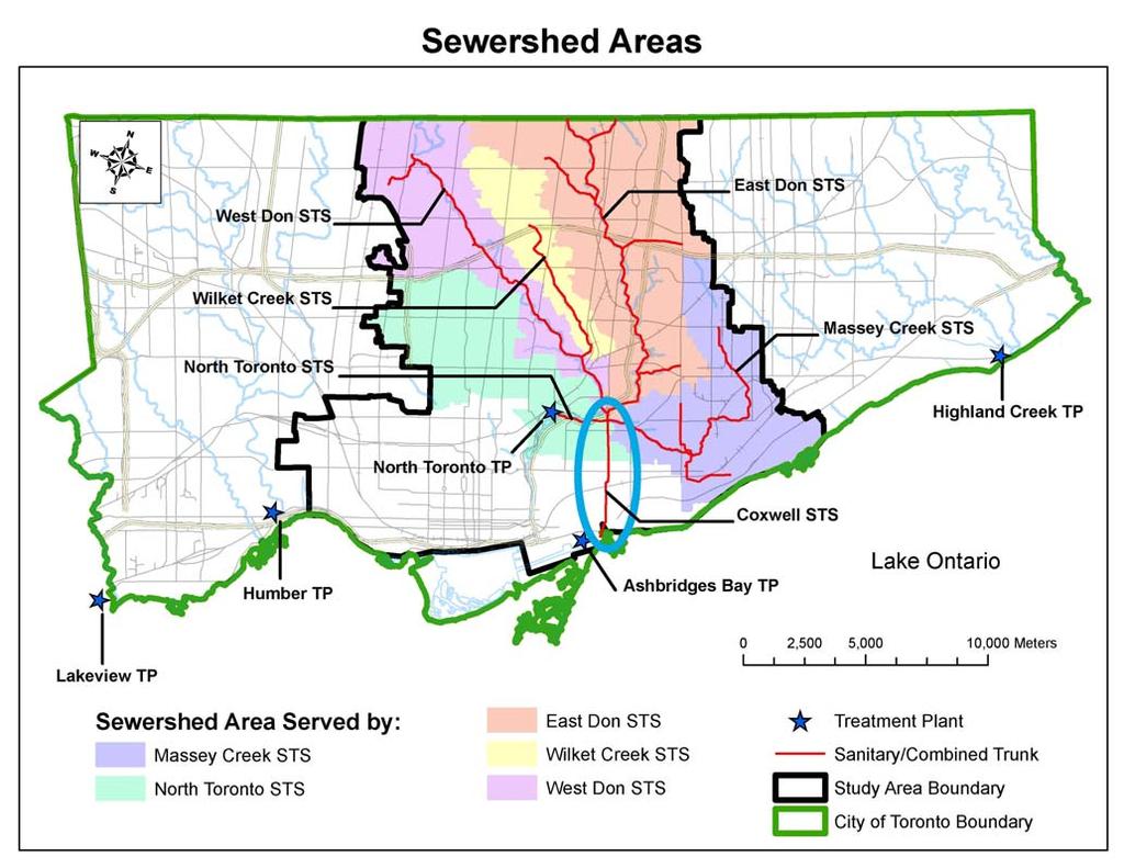
62 Attachment 1 66
63 Attachment 2 67
64 TO: FROM: Chair and Members of the Executive Committee Meeting #4/10, June 4, 2010 Carolyn Woodland, Director, Planning and Development Item EX10.1 RE: APPLICATIONS FOR PERMITS PURSUANT TO ONTARIO REGULATION 166/06 Development, Interference with Wetlands and Alterations to Shorelines and Watercourses KEY ISSUE Pursuant to Ontario Regulation 166/06, written permission from the Authority is required for: a) straightening, changing, diverting or interfering in any way with the existing channel of a river, creek, stream or watercourse, or for changing or interfering in any way with a wetland; b) development, if in the opinion of the authority, the control of flooding, erosion, dynamic beaches or pollution or the conservation of land may be affected by the development. A permit may be refused through a Hearing Process, if in the opinion of the Authority, the control of flooding, erosion, dynamic beaches, pollution or the conservation of land is affected. RECOMMENDATION THAT permits be granted in accordance with Ontario Regulation 166/06 for the applications which are listed below: CITY OF BRAMPTON EX ONTARIO INC. To site grade on Plan 809, (8460 Torbram Road), in the City of Brampton, Mimico Creek Watershed as located on the property owned by Ontario Inc.. The purpose is to undertake works within a TRCA Regulated Area of the Mimico Creek Watershed in order to facilitate the construction of a paved vehicle access and parking associated with an existing commercial building. 68

65 The permit will be issued for the period of June 4, 2010 to June 3, 2012 in accordance with the following documents and plans which form part of this permit: Site Plan Servicing and Grading Plan, Drawing SP/1C, prepared by Ted Van Lankveld Land Surveyors, dated May 2010, stamped received by TRCA Planning and Development May 13, 2010; Tree Preservation and Landscape Plan, Drawing L1, prepared by Strybos Barron King Landscape Architecture, dated February 22, 2010, stamped received by TRCA Planning and Development March 31, RATIONALE The application was reviewed by staff on the basis of the following information: Proposal: The purpose is to undertake works within a TRCA Regulated Area of the Mimico Creek Watershed in order to facilitate the construction of a paved vehicle access and parking associated with an existing commercial building. The subject lands are located in an approved plan of subdivision in the City of Brampton and contains a portion of valley corridor associated with the Mimico Creek Watershed. Based on a site inspection conducted by TRCA staff, it has been confirmed that the vehicle access and parking are sufficiently setback from the valley corridor. The area to which this application applies is currently gravel, as such no significant vegetation will be removed as a result of development, however the applicant has committed to providing an enhancement planting plan for the portion of valley corridor on the subject lands. Control of Flooding: The subject lands are located outside of the Regional Storm Floodplain. As such, no impacts to the storage and/or conveyance of floodwaters is anticipated. Pollution: Appropriate erosion and sediment controls will be utilized throughout all phases of construction. 69
66 Dynamic Beaches: Not applicable Erosion: There are no geotechnical and/or slope stability concerns associated with this application. Conservation of Land: No significant vegetation will be removed as a result of construction. Plantings Although no vegetation will be removed as a result of construction, the applicant has committed to providing native and non-invasive plantings within the valley portion of the subject lands. Policy Guidelines: This proposal is consistent with Section (E) - Property Improvements and Ancillary Structures - of the Authority's Valley and Stream Corridor Management Program (VSCMP). CFN: Application #: 0276/10/BRAM Report Prepared by: Lisa Stern, extension 5370 For information contact: Lisa Stern, extension 5370 Date: May 26, 2010 CITY OF MISSISSAUGA EX LANCASTER AVENUE To construct, reconstruct, erect or place a building or structure on Lot 191, Plan 436, (7170 Lancaster Avenue), in the City of Mississauga, Mimico Creek Watershed. The purpose is to undertake works within a TRCA Regulated Area of the Mimico Creek Watershed in order to facilitate the construction of a square metre (188 sq. ft.) porch enclosure associated with a municipal building permit. 70
67 The permit will be issued for the period of June 4, 2010 to June 3, 2012 in accordance with the following documents and plans which form part of this permit: Site Plan, prepared by V. Riskovski, stamped received by TRCA Planning & Development staff on March 25, 2010; Elevation A, prepared by V. Riskovski, stamped received by TRCA Planning & Development staff on March 25, 2010; Elevation B, prepared by V. Riskovski, stamped received by TRCA Planning & Development staff on March 25, 2010; Elevation C, prepared by V. Riskovski, stamped received by TRCA Planning & Development staff on March 25, RATIONALE The application was reviewed by staff on the basis of the following information: Proposal: The purpose of this application is to undertake works within a TRCA Regulated Area of the Mimico Creek Watershed in order to facilitate the construction of a square metre (188 sq. ft.) porch enclosure at 3051 Victory Crescent, in the City of Mississauga. The proposed works are adjacent to a tributary of the Mimico Creek Watershed. A portion of the property is located within the Regional Storm Floodplain, however, the proposed enclosure is located outside of the Regional Storm Floodplain and is sufficiently setback from the flood hazard. The location of the proposed enclosure is void of any significant natural features, and there are no geotechnical or ecology related concerns with this application. Control of Flooding: The proposed works are located outside of the Regional Storm Floodplain. As such, no impacts to the storage and/or conveyance of flood waters are anticipated. Pollution: Appropriate erosion and sediment controls (i.e., silt fence) have been proposed with this application, and will be maintained throughout all phases of construction. 71
68 Dynamic Beaches: Not applicable. Erosion: There are no geotechnical and/or slope stability concerns anticipated with this project. Conservation of Land: No significant vegetation will be removed as a result of this project. There are no fisheries related concerns associated with this project. Plantings As no vegetation is to be removed by the proposed works, plantings are not required as an element of this application. Policy Guidelines: This proposal is in conformity with Section (B) Minor Additions of the Authority s Valley and Stream Corridor Management Program (VSCMP). CFN: Application #: 0020/10/MISS Report Prepared by: Jason Wagler, extension 5743 For information contact: Quentin Hanchard, extension 5324 Date: May 26, 2010 CITY OF PICKERING EX10.3 COUGS (TILLINGS) LIMITED To site grade and interfere with a wetland on Part Lot 20, Concession 3, (Brock Road and Taunton Road), in the City of Pickering, Duffins Creek Watershed as located on the property owned by Cougs (Tillings) Limited. The purpose is to site grade and interfere with a wetland to facilitate the removal of vegetation and installation of temporary erosion and sediment controls. 72
69 The permit will be issued for the period of June 4, 2010 to June 3, 2012 in accordance with the following documents and plans which form part of this permit: Letter of Undertaking from Cougs (Tillings) Limited,received on May 27, 2010 whereby Cougs (Tillings) Limited agrees to provide an Erosion and Sediment Control Report and associated engineering drawings consistent with the Erosion and Sediment Control Guidelines for Urban Construction to the satisfaction of TRCA staff, and will not begin tree removals on the subject property nor interfere with or alter any wetlands prior to August 1, 2010 and until the TRCA permit has been issued. RATIONALE The application was reviewed by staff on the basis of the following information: Proposal: The proposal is to interfere with a wetland to facilitate the removal of vegetation and installation of temporary erosion and sediment controls in preparation for the construction of a residential subdivision. The site is located on the west side of Tillings Road, south and west of Brock Road and Taunton Road in the City of Pickering. The site is not located within the valley corridor but includes shallow wetlands identified in the TRCA's regulatory mapping. The subdivision is part of the proposed Duffin Heights Neighbourhood. The neighbourhood was subject to a municipal Official Plan Amendment and an on-going Master Environmental Servicing Plan (MESP) process which addressed issues such as overall protection and enhancement of the natural heritage system as well as water management. The Draft Plan of Subdivision has been approved with conditions. As part of the planning process, an additional approximately 38 hectares of lands formerly identified for development within the Duffin Heights neighbourhood were protected as part of the natural heritage system to mitigate the impacts from those remaining lands that will be developed. This site has for many years been designated for development in the City of Pickering Official Plan. As such, when the MESP was reviewed, compensation for the loss of shallow wetland habitat and vegetation on this site and others was made a requirement of approvals. The compensation will take place on public lands currently cleared and used for agriculture and formerly slated for development. The owner shall be required to provide the cost of compensation to the City of Pickering prior to release of the permit. In addition, a monitoring program funded by the developer group is required. Similarly, the owner's proportionate share of the cost of the monitoring program shall be provided to TRCA prior to the release of the permit. While the MESP is not fully complete, TRCA staff anticipate the City, TRCA, applicant and other landowners in Duffin Heights finalizing the MESP in the near future, and this application will not compromise the MESP. 73
70 Conditional Permit: The issuance of this permit is conditional upon: 1) the owner providing the appropriate compensation funds to the City of Pickering as required in the Duffin Heights MESP; 2) the owner providing it's proportionate share of the required monitoring funds as required in the Duffin Heights MESP; 3) the owner providing an Erosion and Sediment Control Report and associated engineering drawings consistent with the Erosion and Sediment Control Guidelines for Urban Construction, to the satisfaction of TRCA staff. The permit will not be issued until after August 1, 2010 and works will not occur during migratory bird nesting or amphibian breeding season. Control of Flooding: The subject property is not within the Regional Storm Floodplain and the proposal will have no impact on the control of flooding. Pollution: The proposal includes a detailed Erosion and Sediment Control Plan to prevent construction related sediment from moving downstream. Dynamic Beaches: Not applicable. Erosion: The proposal includes a detailed Erosion and Sediment Control Plan to prevent downstream erosion. Conservation of Land: The master planning for the Duffin Heights neighbourhood took into account the protection and enhancement of the overall natural heritage system. The loss of the wetland and vegetation was considered in the overall context of this plan and suitable compensation is provided. Plantings Appropriate compensation habitat will be provided on provincially owned land in the Duffin Heights neighbourhood. Policy Guidelines: The works are consistent with Section 4.1, New Development, of the TRCA's Valley and Stream Corridor Management Program. CFN: Application #: 0368/10/PICK Report Prepared by: Steve Heuchert, extension 5311 For information contact: Steve Heuchert, extension 5311 Date: May 25, 2010 EX SOUTHCOTT ROAD To construct, reconstruct, erect or place a building or structure and site grade on Lot 13, Concession 2 Lot 13, Plan 26439, (2298 Southcott Road), in the City of Pickering, Duffins Creek Watershed. 74
71 The purpose is to undertake works within a TRCA Regulated Area of the Duffins Creek Watershed in order to facilitate the construction of an in-ground pool and associated landscaping. The permit will be issued for the period of June 4, 2010 to June 3, 2012 in accordance with the following documents and plans which form part of this permit: Pool Layout Plan, prepared by Pool Craft, dated April 12, 2010, stamped received by TRCA Planning and Development May 4, RATIONALE The application was reviewed by staff on the basis of the following information: Proposal: The applicant seeks permission to construct and in-ground pool and associated landscaping within a Regulated Area associated with a tributary of the Duffins Creek. The subject lands are located adjacent to valleylands in an approved residential subdivision within the Brock Ridge neighbourhood in the City of Pickering, east of Brock Road, south of Rossland Road. Based on a site inspection conducted by TRCA staff, it has been confirmed that the proposed pool is sufficiently setback from the valley corridor. The area to which this application applies is currently manicured lawn, as such no significant vegetation will be removed as a result of development. Control of Flooding: The subject lands are located outside of the Regional Storm Flood Plain. As such, there will be no impacts to the storage and/or conveyance of floodwaters. Pollution: Appropriate erosion and sediment controls are to be erected through all phases of construction to prevent sedimentation of the adjacent valleylands. 75
72 Dynamic Beaches: Not applicable Erosion: There are no geotechnical and/or slope stability concerns associated with this application. Conservation of Land: No significant vegetation will be removed as a result of construction. Plantings Since no significant vegetation will be removed, additional plantings are not required. Policy Guidelines: This proposal is consistent with Section (E), Property Improvements and Ancillary Structures, of TRCA's Valley and Stream Corridor Management Program (VSCMP). CFN: Application #: 0382/10/PICK Report Prepared by: Chris Jones, extension 5718 For information contact: Steve Heuchert, extension 5311 Date: May 25, 2010 CITY OF TORONTO [ETOBICOKE YORK COMMUNITY COUNCIL AREA] EX ELLIS AVENUE To construct, reconstruct, erect or place a building or structure, site grade and temporarily or permanently place, dump or remove any material, originating on the site or elsewhere on Lot 313, Plan M-438, (94 Ellis Avenue), in the City of Toronto (Etobicoke York Community Council Area), Humber River Watershed. The purpose is to construct a permeable paved parking pad, associated terraced retaining structure, replacement staircase and concrete landings to the front/side of the existing semi-detached dwelling at 94 Ellis Avenue in the City of Toronto (Etobicoke York Community Council Area). 76

73 The permit will be issued for the period of June 4, 2010 to June 3, 2012 in accordance with the following documents and plans which form part of this permit: Drawing No. L1, Landscape Layout, prepared by Holbrook & Associates, dated November 16, 2009, received on May 13, 2010, redlined by TRCA staff on May 25, 2010; Drawing No. L2, Landscape Sections, prepared by Holbrook & Associates, dated November 16, 2009, received on May 13, 2010; Drawing No. S1, Retaining Walls Plan, prepared by Alex Gamaley, dated April 2010, received on May 13, 2010; Drawing No. S2, Sections, prepared by Alex Gamaley, dated April 2010, received on May 13, RATIONALE The application was reviewed by staff on the basis of the following information: Proposal: The purpose of this application is to develop within a TRCA Regulated Area of the Humber River Watershed in order to facilitate the construction of a permeable paved parking pad, associated terraced retaining structure, replacement staircase and concrete landings to the front/side of the existing semi-detached dwelling at 94 Ellis Avenue. The subject site is located north of The Queensway and east of South Kingsway within a TRCA Regulated Area of the Humber River Watershed. Control of Flooding: The site is not located within a regional storm flood plain and the proposal will have no impact on the storage and/or conveyance of floodwaters. Pollution: Sediment controls will be installed and maintained during construction to prevent debris from entering the watercourse. 77
74 Dynamic Beaches: Not applicable. Erosion: A geotechnical report has been reviewed and approved by TRCA geotechnical engineering staff and the proposal will be constructed in accordance with the recommendations of this report. Conservation of Land: The proposed works are located no further than the existing limit of development. There are no other significant natural features on, or adjacent to, the site that would be negatively impacted by the project. Plantings Native plantings will be provided as per City of Toronto Urban Forestry Ravine Protection Services Guidelines and recommendations pertaining to tree protection and maintenance during construction will be implemented. Policy Guidelines: The proposal is consistent with Section (E) - Development Guidelines for Property Improvements and Ancillary Structures within Non-Established/Highly Urbanized Areas of the TRCA s Valley and Stream Corridor Management Program. CFN: Application #: 0419/10/TOR Report Prepared by: Nicole Moxley, extension 5284 For information contact: Steve Heuchert, extension 5311 Date: May 25, 2010 EX SOUTH KINGSWAY To construct, reconstruct, erect or place a building or structure and change a building or structure so that it alters its use or potential use, increases its size or increases the number of dwelling units on Lot 58, Plan M-523, Lot 72, Plan 2663, (92 South Kingsway), in the City of Toronto (Etobicoke York Community Council Area), Humber River Watershed. 78
.")
75 The purpose is to construct a two-storey rear addition, second storey addition, partial third storey addition and rear deck to the existing single family detached dwelling at 92 South Kingsway in the City of Toronto (Etobicoke York Community Council Area). The permit will be issued for the period of June 4, 2010 to June 3, 2012 in accordance with the following documents and plans which form part of this permit: Drawing No. S-1, Site Plan, prepared by Linebox Studio Inc., dated April 20, 2010, received on April 27, 2010; Drawing No. A-6, East and West Elevations, prepared by Linebox Studio Inc., dated April 20, 2010, received on April 27, 2010; Drawing No. A-7, North Elevation, prepared by Linebox Studio Inc., dated April 20, 2010, received on April 27, 2010; Drawing No. A-8, South Elevation, prepared by Linebox Studio Inc., dated April 20, 2010, received on April 27, RATIONALE The application was reviewed by staff on the basis of the following information: Proposal: The purpose of this application is to develop within a TRCA Regulated Area of the Humber River Watershed in order to facilitate the construction of two-storey rear addition, second storey addition, partial third storey addition and rear deck to the existing single family detached dwelling at 92 South Kingsway. The subject site is located on the west side of South Kingsway and south of Bloor Street West in the City of Toronto (Etobicoke York Community Council Area). Control of Flooding: The site is not located within a regional storm flood plain and the proposal will have no impact on the storage and/or conveyance of floodwaters. 79
76 Pollution: Sediment controls are not required as the subject site is located at the toe of a slope and removed from the watercourse. Dynamic Beaches: Not applicable. Erosion: There are no slope stability/geotechnical concerns associated with this application. Conservation of Land: The proposed works are adequately set back from the toe of slope. The appropriate tree protection fencing will be installed. Plantings Native plantings will be provided as per City of Toronto Urban Forestry Ravine Protection Services Guidelines and recommendations pertaining to tree protection and maintenance during construction will be implemented. Policy Guidelines: This proposal is consistent with Section (B) and (E) - Development Guidelines for Minor Additions, Property Improvements and Ancillary Structures within Non-Established/Highly Urbanized Areas of the TRCA's Valley and Stream Corridor Management Program. CFN: Application #: 0350/10/TOR Report Prepared by: Nicole Moxley, extension 5284 For information contact: Steve Heuchert, extension 5311 Date: May 25, 2010 EX HUMBERVALE BOULEVARD To change a building or structure so that it alters its use or potential use, increases its size or increases the number of dwelling units, site grade and temporarily or permanently place, dump or remove any material, originating on the site or elsewhere on Parts 15, 16 Plan 4RP64R9669, (162 Humbervale Boulevard), in the City of Toronto (Etobicoke York Community Council Area), Mimico Creek Watershed. 80
.")
77 The purpose is to construct a two-storey rear addition, partial second storey addition and rear deck to the existing single family detached dwelling at 162 Humbervale Boulevard in the City of Toronto (Etobicoke York Community Council Area). The permit will be issued for the period of June 4, 2010 to June 3, 2012 in accordance with the following documents and plans which form part of this permit: Drawing No. A0, Site Plan, prepared by In House Designs, dated March 28, 2010, received on April 28, 2010; Drawing No. A3, Front Elevation, prepared by In House Designs, dated January 28, 2010, received on April 28, 2010; Drawing No. A4, Rear Elevation, prepared by In House Designs, dated January 28, 2010, received on April 28, 2010; Drawing No. A5, North Elevation, prepared by In House Designs, dated January 28, 2010, received on April 28, 2010; Drawing No. A6, South Elevation, prepared by In House Designs, dated January 28, 2010, received on April 28, RATIONALE The application was reviewed by staff on the basis of the following information: Proposal: The purpose of this application is to develop within a TRCA Regulated Area of the Mimico Creek Watershed in order to facilitate the construction of a two-storey rear addition, partial second storey addition and rear deck to the existing single family detached dwelling at 162 Humbervale Boulevard. The subject site is located east of Royal York Road and south of Bloor Street West in the City of Toronto (Etobicoke York Community Council Area). Control of Flooding: This site is not located in the Regional Storm Floodplain and the proposal will have no impact on the storage and/or conveyance of floodwaters. 81
78 Pollution: Appropriate erosion and sediment controls will be installed and maintained throughout all phases of construction. Dynamic Beaches: Not applicable. Erosion: There are no slope stability/geotechnical concerns associated with this application. Conservation of Land: The proposed works are located no further than the existing limit of development. The appropriate tree protection fencing will be installed. Plantings Native plantings will be provided as per City of Toronto Urban Forestry Ravine Protection Services Guidelines and recommendations pertaining to tree protection and maintenance during construction will be implemented. Policy Guidelines: This proposal is consistent with Section (B) and (E) - Development Guidelines for Minor Additions, Property Improvements and Ancillary Structures within Non-Established/Highly Urbanized Areas of the TRCA's Valley and Stream Corridor Management Program. CFN: Application #: 0377/10/TOR Report Prepared by: Nicole Moxley, extension 5284 For information contact: Steve Heuchert, extension 5311 Date: May 25, 2010 CITY OF TORONTO [NORTH YORK COMMUNITY COUNCIL AREA] EX ONTARIO INC. To construct, reconstruct, erect or place a building or structure, site grade and temporarily or permanently place, dump or remove any material, originating on the site or elsewhere on Lot 17 AND PART OF LOT 18, Plan 2478, (17 Plymbridge Crescent), in the City of Toronto (North York Community Council Area), Don River Watershed as located on the property owned by Ontario Inc.. 82

79 The purpose is to develop within a Regulated Area of the Don River watershed to facilitate construction of a replacement two-storey dwelling and in-ground pool. The permit will be issued for the period of June 4, 2010 to June 3, 2012 in accordance with the following documents and plans which form part of this permit: Drawing No. A1, Proposed Site Plan, author unknown, undated, received by TRCA January 25, 2010; Drawing No. A2, Basement Floor Plan, prepared by Lorne Rose Architect, dated January 15, 2010, received by TRCA January 25, 2010; Drawing No. A3, Ground Floor Plan, prepared by Lorne Rose Architect, dated January 15, 2010, received by TRCA January 25, 2010; Drawing No. A4, Second Floor Plan, prepared by Lorne Rose Architect, dated January 15, 2010, received by TRCA January 25, 2010; Drawing No. A5, Grading Plan, author unknown, undated, received by TRCA May 12, RATIONALE The application was reviewed by staff on the basis of the following information: Proposal: The proposed works include construction of a replacement two-storey dwelling and in-ground pool at 17 Plymbridge Crescent in the City of Toronto. The site is located south of York Mills Road, east of Yonge Street, within the Hoggs Hollow Special Policy Area. Control of Flooding: The dwelling will be floodproofed to the Regional Storm Flood elevation. Additionally, a letter from a structural engineer has been received stating that the proposed works can withstand the depths and velocities under the Regional Storm Flood event. Pollution: Sediment control fencing is not required as the site is not located adjacent to the watercourse. 83

80 Dynamic Beaches: Not applicable Erosion: There are no geotechnical concerns associated with this application. Conservation of Land: No significant vegetation will be removed as a result of construction. Plantings Native tree shrub and seed mix will be planted in accordance with the Ravine and Natural Features Protection Bylaw. Policy Guidelines: This proposal is consistent with Section (B), Development Guidelines for Development/Redevelopment within Designated Two Zone Areas or Special Policy Areas, of TRCA's Valley and Stream Corridor Management Program. CFN: Application #: 0073/10/TOR Report Prepared by: Michelle Stafford, extension 5250 For information contact: Steve Heuchert, extension 5311 Date: May 26, 2010 EX VIAMEDE CRESCENT To change a building or structure so that it alters its use or potential use, increases its size or increases the number of dwelling units on Lot 8, Plan 5482, (18 Viamede Crescent), in the City of Toronto (North York Community Council Area), Don River Watershed. The purpose is to develop within a Regulated Area of the Don River watershed to facilitate construction of one-storey addition to the front of the existing one-storey dwelling. 84
81 The permit will be issued for the period of June 4, 2010 to June 3, 2012 in accordance with the following documents and plans which form part of this permit: Drawing No. A01, Site Plan, prepared by Axiis Architect Design Inc., dated September 2008, received by TRCA March 26, 2010; Drawing No. A02, Basement Plan, prepared by Axiis Architect Design Inc., dated September 2008, received by TRCA March 26, 2010; Drawing No. A03, Ground Floor Plan, prepared by Axiis Architect Design Inc., dated September 2008, received by TRCA March 26, 2010; Drawing No. A04, Elevations, prepared by Axiis Architect Design Inc., dated September 2008, received by TRCA March 26, 2010; Drawing No. A05, Elevations, prepared by Axiis Architect Design Inc., dated September 2008, received by TRCA March 26, RATIONALE The application was reviewed by staff on the basis of the following information: Proposal: The proposed works include a one-storey addition to the front of the existing dwelling at 18 Viamede Crescent in the City of Toronto. The site is located south of Finch Avenue West, east of Bayview Avenue. Control of Flooding: The site is not located within the Regional Storm Floodplain. Pollution: Sediment control fencing is not required as the subject property is adequately setback from any natural features. Dynamic Beaches: Not applicable Erosion: There are no geotechnical concerns associated with this application. Conservation of Land: No significant vegetation will be removed as a result of construction. Plantings No plantings are required as part of this project. Policy Guidelines: The proposal is consistent with Section (C), Minor Additions, of TRCA's Valley and Stream Corridor Management Program. 85

82 CFN: Application #: 0273/10/TOR Report Prepared by: Michelle Stafford, extension 5250 For information contact: Steve Heuchert, extension 5311 Date: May 25, 2010 EX GWENDOLEN CRESCENT To change a building or structure so that it alters its use or potential use, increases its size or increases the number of dwelling units on Part Lot 16, Plan 4060, (90 Gwendolen Crescent), in the City of Toronto (North York Community Council Area), Don River Watershed. The purpose is to develop within a Regulated Area of the Don River watershed to facilitate construction of a two-storey addition to the front, and a second-storey addition over the existing one-storey dwelling. The permit will be issued for the period of June 4, 2010 to June 3, 2012 in accordance with the following documents and plans which form part of this permit: Drawing No. 1, Site Plan, prepared by Sasha Milenov, Architect, dated February 24, 2010, received by TRCA May 5, 2010; Drawing No. 2, Basement Plan, prepared Sasha Milenov, Architect, undated, received by TRCA May 5, 2010; Drawing No. 3, Ground Floor Plan, prepared Sasha Milenov, Architect, undated, received by TRCA May 5, 2010; Drawing No. 4, Second Floor Plan, prepared Sasha Milenov, Architect, undated, received by TRCA May 5, RATIONALE The application was reviewed by staff on the basis of the following information: 86
83 Proposal: The proposed works include construction of a two-storey addition at the front, and a second-storey addition over the existing one-storey dwelling located at 90 Gwendolen Crescent in the City of Toronto. An existing concrete patio will be replaced with interlocking brick pavers. The subject property is located south of Sheppard Avenue West, east of Bathurst Street. Control of Flooding: The site is not located in the Regional Storm Floodplain. Pollution: Sediment control fencing will be erected prior to commencement of any construction or grading works and will remain in place until the proposed works have been completed and any exposed areas have been stabilized. Dynamic Beaches: Not applicable Erosion: A geotechnical investigation has been reviewed and approved by TRCA geotechnical engineering staff and the proposed work will be located within the existing limit of development. Conservation of Land: No significant vegetation will be removed as a result of construction. Plantings No plantings are required as part of this project. Policy Guidelines: The proposal is consistent with Section (C), Minor Additions, of TRCA's Valley and Stream Corridor Management Program. CFN: Application #: 0408/10/TOR Report Prepared by: Michelle Stafford, extension 5250 For information contact: Steve Heuchert, extension 5311 Date: May 25, 2010 EX RIVERVIEW DRIVE To construct, reconstruct, erect or place a building or structure, site grade and temporarily or permanently place, dump or remove any material, originating on the site or elsewhere on Lot 74, 75, Plan M275, (320 Riverview Drive), in the City of Toronto (North York Community Council Area), Don River Watershed. 87
84 The purpose is to develop within a Regulated Area of the Don River watershed to facilitate construction of an in-ground pool and replacement retaining wall. The permit will be issued for the period of June 4, 2010 to June 3, 2012 in accordance with the following documents and plans which form part of this permit: Drawing No. SP, Site Plan, prepared by Newman Cebulak, dated March 10, 2010, received by TRCA April 12, 2010; Drawing No. LP, Landscaping Plan, prepared by Newman Cebulak, dated March 10, 2010, received by TRCA April 12, 2010; Drawing No. STM-1, Stormwater Management Plan Erosion & Sediment Control Plan, prepared by Gunnell Engineering Ltd., dated April 17, 2010, received by TRCA May 13, RATIONALE The application was reviewed by staff on the basis of the following information: Proposal: The proposed works include the construction of a new in-ground swimming pool and replacement retaining wall in the rear yard of the existing dwelling at 320 Riverview Drive in the City of Toronto. The site is located west of Bayview Avenue, north of Lawrence Avenue East. Control of Flooding: The site is not located in the Regional Storm Floodplain. Pollution: Sediment control fencing will be installed prior to commencement of any construction or grading works, and will remain in place until construction is completed and any exposed soils stabilized. Dynamic Beaches: Not applicable 88
85 Erosion: A geotechnical investigation has been reviewed and approved by TRCA geotechnical engineering staff and the proposed works will be adequately set back from the top-of-bank. Conservation of Land: No significant vegetation will be removed as a result of construction. Appropriate tree protection fencing will be installed prior to construction activities. Plantings Native tree shrub and seed mix will be planted in accordance with the City of Toronto Ravine and Natural Feature Protection By-law. Policy Guidelines: The proposal is consistent with Section (D), Replacement Structures, and (E), Property Improvements and Ancillary Structures, of TRCA's Valley and Stream Corridor Management Program. CFN: Application #: 0978/09/TOR Report Prepared by: Michelle Stafford, extension 5250 For information contact: Steve Heuchert, extension 5311 Date: May 26, 2010 CITY OF TORONTO [SCARBOROUGH COMMUNITY COUNCIL AREA] EX10.12 ALTRIDGE PROPERTIES INC. To construct, reconstruct, erect or place a building or structure, site grade and temporarily or permanently place, dump or remove any material, originating on the site or elsewhere on Part Lot 31, 32, Plan 2098, (103, 105, 109 Scarboro Avenue), in the City of Toronto (Scarborough Community Council Area), Highland Creek Watershed as located on the property owned by Altridge Properties Inc.. The purpose is to construct a new roadway (cul-de-sac) and five new single family dwellings. 89

86 The permit will be issued for the period of June 4, 2010 to June 3, 2012 in accordance with the following documents and plans which form part of this permit: Drawing No. CPP, Composite Planting Plan, prepared by Aboud Associates Inc., dated Jan., 2010, received January 21, 2010; Drawing No , Grading Plan, Notes & Details, prepared by IBI Group, dated Aug. 2008, received January 21, 2010; Drawing No , Erosion & Sediment Control Plan, prepared by IBI Group, dated Aug. 2008, received January 21, 2010, redlined by TRCA staff on May 25, 2010; Drawing No CMP1, Construction Management Plan, prepared by IBI Group, dated Aug. 2008, received January 21, RATIONALE The application was reviewed by staff on the basis of the following information: Proposal: It is proposed to construct an extension of the Fawnridge Trail Subdivision which includes a new public roadway (cul-de-sac) and 5 new single family detached residential dwellings. The new lots and public road were recently created by plan of subdivision. The bulb portion of the roadway and lot 1 are adjacent to the Centennial Creek stream corridor. The applicant has satisfied all draft conditions of subdivision approval including the requirement to convey to public ownership Block 6 which is the stream corridor portion of the subject lands. Control of Flooding: The proposed development is not located within the Regional Storm Floodplain, therefore there are no flooding concerns. Pollution: Appropriate sediment fencing will be in place throughout the duration of construction to ensure that no sediment will enter Centennial Creek. 90
87 Dynamic Beaches: Not applicable Erosion: Not applicable Conservation of Land: A comprehensive planting plan has been reviewed and approved by TRCA and Urban Forestry staff at the City of Toronto. Plantings All plantings will be in accordance with TRCA's Post-Construction Restoration Guidelines and Seed Mix Guidelines. Policy Guidelines: The proposal is consistent with Section Development and Redevelopment/Intensification within Non-Established Communities/Highly Urbanized Areas, of the Authority's Valley and Stream Corridor Management Program. CFN: Application #: 0068/10/TOR Report Prepared by: Mark Rapus, extension 5259 For information contact: Mark Rapus, extension 5259 Date: May 26, 2010 EX COLONEL DANFORTH TRAIL To construct, reconstruct, erect or place a building or structure, site grade and temporarily or permanently place, dump or remove any material, originating on the site or elsewhere on Lot 24, 25, Plan 2546, (83 Colonel Danforth Trail), in the City of Toronto (Scarborough Community Council Area), Highland Creek Watershed. The purpose is to construct a new wooden deck to replace the existing concrete slab deck to the rear of the existing single family detached dwelling at 83 Colonel Danforth Trail in the City of Toronto (Scarborough Community Council Area). This proposal also includes slope restoration works and a garden shed. The existing shed is to be demolished. 91
88 The permit will be issued for the period of June 4, 2010 to June 3, 2012 in accordance with the following documents and plans which form part of this permit: Drawing No. L1 of 6, Tree Assessment/Sediment Control Plan, prepared by Sunarts Design, dated October 2009, Revision No. 5, revised on May 6, 2010, received on May 7, 2010, redline revised by TRCA staff on May 25, 2010; Drawing No. L2 of 6, Landscape Plan, prepared by Sunarts Design, dated October 2009, Revision No. 5, revised on May 6, 2010, received on May 7, 2010, redline revised by TRCA staff on May 25, 2010; Drawing No. L3 of 6, Ravine Stewardship Plan, prepared by Sunarts Design, dated October 2009, Revision No. 5, revised on May 6, 2010, received on May 7, 2010, redline revised by TRCA staff on May 25, 2010; Drawing No. L4 of 6, Landscape Elevation/Details, prepared by Sunarts Design, dated October 2009, Revision No. 5, revised on May 6, 2010, received on May 7, 2010; Drawing No. L5 of 6, Ravine Stewardship Details/Notes, prepared by Sunarts Design, dated October 2009, Revision No. 5, revised on May 6, 2010, received on May 7, 2010; Drawing No. L6 of 6, Tree Protection/Sediment Control Details/Elevations, prepared by Sunarts Design, dated October 2009, Revision No. 5, revised on May 6, 2010, received on May 7, RATIONALE The application was reviewed by staff on the basis of the following information: Proposal: The purpose of this application is to develop within a TRCA Regulated Area of the Highland Creek Watershed in order to facilitate the construction of a new wooden deck to replace the existing concrete slab deck to the rear of the single family detached dwelling at 83 Colonel Danforth Trail. This proposal also includes slope restoration works and a garden shed. The existing shed is to be demolished. The subject site is located east of Morningside Avenue and south of Kingston Road in the City of Toronto (Scarborough Community Council Area). 92
89 Control of Flooding: The site is not located within a regional storm flood plain and the proposal will have no impact on the storage and/or conveyance of floodwaters. Pollution: Appropriate erosion and sediment controls will be installed and maintained throughout all phases of construction. Dynamic Beaches: Not applicable. Erosion: A geotechnical slope stability report has been reviewed and approved by TRCA geotechnical engineering staff and the proposal will be constructed in accordance with the recommendations of this report. A geotechnical engineering consultant will be retained to provide on-site professional advice during construction. Conservation of Land: The proposed works are located no further than the existing limit of development. The appropriate tree protection fencing will be installed. Plantings A ravine stewardship plan will be implemented. Native plantings will be provided as per Urban Forestry Ravine Protection Services Guidelines and recommendations pertaining to tree protection and maintenance during construction will be implemented. Policy Guidelines: This proposal is consistent with Section (D) - Development Guidelines for Replacement Structures within Non-Established/Highly Urbanized Areas of the TRCA's Valley and Stream Corridor Management Program. CFN: Application #: 0103/10/TOR Report Prepared by: Nicole Moxley, extension 5284 For information contact: Steve Heuchert, extension 5311 Date: May 25, 2010 CITY OF VAUGHAN EX10.14 CANADIAN PACIFIC To construct, reconstruct, erect or place a building or structure and alter a watercourse which is a tributary of Robinson Creek at the CP Rail Mactier Subdivision crossing, in the City of Vaughan, Humber River Watershed as located on the property owned by Canadian Pacific. 93
90 The purpose is to install two new culverts over a tributary of Robinson Creek in the City of Vaughan. These culverts will replace an existing culvert within a Regulated Area of the Humber River watershed. The permit will be issued for the period of June 4, 2010 to June 3, 2012 in accordance with the following documents and plans which form part of this permit: Culvert Plan and Section, Drawing No. 1, prepared by Dillon Consulting, dated April 12, 2010, received by the TRCA May 18, 2010; Sediment and Erosion Control and Revegetation Plan, Drawing No. 2, prepared by Dillon Consulting, dated April 12, 2010, received by the TRCA May 18, 2010; Sediment and Erosion Control Details, Drawing No. 3, prepared by Dillon Consulting, dated April 12, 2010, received by the TRCA May 18, 2010; Staging Plan, Drawing No. 4, prepared by Dillon Consulting, dated April 12, 2010, received by the TRCA May 18, RATIONALE The application was reviewed by staff on the basis of the following information: Proposal: The purpose is to replace a single undersized culvert with two new culverts within a Regulated Area of the Humber River watershed. One of the proposed culverts (imbedded) will be the primary replacement culvert and allow fish passage while the second culvert (raised) will allow adequate conveyance of flood waters. The existing culvert will be decommissioned. Based upon the Hydrologic and Hydraulic Assessment prepared by Dillon Consulting, dated June 1, 2009, TRCA water resources engineering staff are satisfied that the proposed works have been adequately designed to address conveyance issues. TRCA ecology staff are satisfied that the proposed works have adequate erosion and sediment control measures and the timing and staging of the works are appropriate for this reach of the tributary. 94
91 Control of Flooding: The proposed works will increase conveyance capacity at this crossing. TRCA water resources engineering staff are satisfied that the proposed works have been adequately designed to address conveyance issues. Pollution: Standard erosion control measures will be in place through the use of coffer dams and by-pass pump around method in order to work in the dry to facilitate construction of the replacement culverts. These measures include the use of the following: silt fence, coffer dams, pump, and erosion control blankets. Dynamic Beaches: Not applicable. Erosion: There are no geotechnical issues associated with this application. Conservation of Land: There will be in stream works associated with this project. The watercourse will be crossed via two replacement culverts. With erosion and sedimentation control plans in effect and the appropriate fisheries timing window of July 1 to September 15, the potential for a harmful alteration, disruption or destruction (HADD) of fish habitat will be mitigated and a Letter of Advice will be written by TRCA staff on behalf of the Department of Fisheries and Oceans (DFO). The proposed works will not impact significant terrestrial resource features. Plantings All disturbed areas will be restored with native/non-invasive species following construction. Policy Guidelines: The proposal is consistent with Section Infrastructure and Servicing - of the Authority's Valley and Stream Corridor Management Program. CFN: Application #: 0761/09/VAUG Report Prepared by: Anthony Sun, extension 5724 For information contact: Bill Kiru, extension 5306 Date: May 19, 2010 EX10.15 CITY OF VAUGHAN To site grade, temporarily or permanently place, dump or remove any material, originating on the site or elsewhere and alter a watercourse in a Regulated Area on Napa Valley Avenue - near Rutherford Road, in the City of Vaughan, Regional Municipality of York, Don River Watershed as located on the property owned by City of Vaughan. 95
92 The purpose is to remove sediment from a stormwater management pond to mitigate the impacts of sediment on the downstream receiving watercourse. A Letter of Advice will be written by TRCA staff on behalf of Fisheries and Oceans Canada (DFO) for this project. The permit will be issued for the period of June 4, 2010 to June 3, 2012 in accordance with the following documents and plans which form part of this permit: Dwg. No. 1 of 2; Storm Pond 105 Rehabilitation; dated March, 2010; received March 8, 2010; red-line revised May 25, 2010; prepared by City of Vaughan; Dwg. No. 2 of 2; Storm Pond 105 Rehabilitation; dated March, 2010; received March 8, 2010; prepared by City of Vaughan. RATIONALE The application was reviewed by staff on the basis of the following information: Proposal: The proposal involves the removal of sediment from a stormwater management pond (Pond #105) on Napa Valley Avenue and Rota Court, north of Rutherford Road, in the City of Vaughan, Regional Municipality of York. The water from the pond will be pumped through pipes to an enviro-bag filter system and discharged to a vegetated ditch to the east of the pond. The sediment will be removed and temporarily stockpiled on site and then disposed of off site. Control of Flooding: The proposed work will not have any impacts to the storage and/or conveyance of flood waters. Pollution: Standard erosion and sediment control measures (silt fencing) will be implemented prior to construction and maintained for the duration of the works in order to prevent sediment from entering any watercourse. Erosion and sediment control measures have been provided in accordance with the TRCA Erosion and Sediment Control Guideline for Urban Construction. 96
93 Dynamic Beaches: Not applicable Erosion: There are no geotechnical/slope stability issues associated with this proposal. Conservation of Land: With erosion and sediment control measures in place, the potential for Harmful, Alteration, Disruption or Destruction (HADD) of fish habitat will be mitigated. A Letter of Advice will be prepared by TRCA staff on behalf of Fisheries and Oceans Canada (DFO) for this project. Plantings All disturbed areas will be restored with native, non-invasive species following construction if required. Policy Guidelines: The proposal complies with Section Infrastructure and Servicing of the Authority's Valley and Stream Corridor Management Program. CFN: Application #: 0185/10/VAUG Report Prepared by: Louise Monaghan, extension 5756 For information contact: Suzanne Bevan, extension 5759 Date: May 26, 2010 EX10.16 CITY OF VAUGHAN To construct, reconstruct, erect or place a building or structure, site grade and temporarily or permanently place, dump or remove any material, originating on the site or elsewhere in a Regulated Area on 3 Maison Parc Court, in the City of Vaughan, Regional Municipality of York, Don River Watershed as located on the property owned by City of Vaughan. The purpose is to construct a new asphalt pedestrian walkway with armourstone edging in Chateau Ridge Park. 97
94 The permit will be issued for the period of June 4, 2010 to June 3, 2012 in accordance with the following documents and plans which form part of this permit: Drawing No. L1; Demolition Plan; dated November 23, 2009; received May 17, 2010; prepared by City of Vaughan Parks; Drawing No. L2; Layout and Planting Plan; dated November 23, 2009; received May 17, 2010; prepared by City of Vaughan Parks; Drawing No. L3; Grading Plan; dated November 23, 2009; received May 17, 2010; prepared by City of Vaughan Parks. RATIONALE The application was reviewed by staff on the basis of the following information: Proposal: The proposal is to construct a 170m asphalt walkway with armourstone edging along both sides of the path within a Regulated Area in Chateau Ridge Park, east of Dufferin Street and north of Steeles Avenue West in the City of Vaughan. The new pedestrian walkway will provide access to Steeles Avenue West for nearby residents. Control of Flooding: The proposed project will have no impacts on the storage or conveyance of floodwaters. Pollution: Standard erosion and sediment control measures (silt fencing) will be implemented prior to construction and maintained for the duration of construction, and until the site is stabilized and restored, in order to prevent construction generated sediments from entering any wetland or watercourse. Erosion and sediment control measures have been provided in accordance with the TRCA Erosion and Sediment Control Guideline for Urban Construction. 98
95 Dynamic Beaches: Not applicable Erosion: There are no geotechnical/slope stability issues associated with the proposal. Conservation of Land: There will no in water works associated with the project and there will be no concerns related to fish habitat. Plantings All disturbed areas will be restored with native non-invasive species following construction. There will be a net gain of 8 trees. The proposed plantings will be consistent with TRCA's guidelines for restoration. Policy Guidelines: The proposal compiles with Section Infrastructure and Servicing, of the Authority's Valley and Stream Corridor Management Program. CFN: Application #: 0215/10/VAUG Report Prepared by: Louise Monaghan, extension 5756 For information contact: Suzanne Bevan, extension 5759 Date: May 26, 2010 EX VAUGHAN MILLS ROAD To construct, reconstruct, erect or place a building or structure on, (29 Vaughan Mills Road), in the City of Vaughan, Humber River Watershed. The purpose is to construct a concrete replacement deck within a Regulated Area of the Humber River watershed at 29 Vaughan Mills Road in the City of Vaughan. 99
96 The permit will be issued for the period of June 4, 2010 to June 3, 2012 in accordance with the following documents and plans which form part of this permit: Site Plan, prepared by the applicant, received by the TRCA March 9, 2010; Concrete Porch Floor Plan, prepared by Bdesign, dated August 10, 2009, received by the TRCA March 9, RATIONALE The application was reviewed by staff on the basis of the following information: Proposal: The purpose is to construct a replacement deck within a Regulated Area of the Humber River watershed. The subject property is located entirely within the Main Humber River valley corridor. Based upon a site visit conducted by TRCA staff on March 23, 2010, the proposed works are located in a flat area of the property devoid of any significant vegetation and the top-of-slope of a vegetated but steep 2 Horizontal : 1 Vertical is located at the rear property boundary. The proposed replacement deck will be located approximately 7.5 metres away from the existing top-of-slope which has been determined to be coincidental with the long-term-stable top-of-slope as indicated in a Geotechnical Assessment prepared by Forza! GeoSolutions, dated April 23, 2010, received by the TRCA April 29, TRCA geotechnical staff are satisfied that provided a 7 metre hardsurfacing setback is maintained, there are no geotechnical issues associated with the construction of the replacement deck. Control of Flooding: The proposed works are not located within the Regional Storm Flood Plain. There will be no impacts on the storage or conveyance of flood waters. Pollution: As the proposed works are located within a flat sodded area and no grading works are required, there are no sediment transport issues associated with this application. Dynamic Beaches: Not applicable. Erosion: TRCA geotechnical staff are satisfied that the proposed works are adequately setback from the long-term-stable top-of-slope and will not have an impact on the stability of the slope feature. Conservation of Land: As a watercourse will not be impacted by the proposal, no fisheries concerns will result. There are no other significant natural features on or adjacent to the site that may be negatively impacted by the project. 100
97 Plantings All disturbed areas will be restored to the existing sodded condition and will not affect any significant natural features. Policy Guidelines: The proposal is consistent with Section E) - Property Improvement and Ancillary Structures and Section D) - Replacement Structures - of the Authority's Valley and Stream Corridor Management Program. CFN: Application #: 0238/10/VAUG Report Prepared by: Anthony Sun, extension 5724 For information contact: Bill Kiru, extension 5306 Date: May 18, 2010 EX10.18 ROYAL PINE HOMES To construct, reconstruct, erect or place a building or structure and site grade on at 93 Grandvista Crescent, in the City of Vaughan, Humber River Watershed as located on the property owned by Royal Pine Homes. The purpose is to recognize a retaining wall constructed within a Regulated Area of the Humber River watershed at 93 Grandvista Crescent in the City of Vaughan.. The permit will be issued for the period of June 4, 2010 to June 3, 2012 in accordance with the following documents and plans which form part of this permit: Site Plan, prepared by Landscape Planning Limited, revise dated May 12, 2010, received by the TRCA May 17, RATIONALE The application was reviewed by staff on the basis of the following information: 101
98 Proposal: The purpose is to recognize an armour stone retaining wall constructed within a Regulated Area of the Humber River watershed. The subject property is located along the edge of a draw feature which forms a part of the valley corridor of a tributary of the East Humber River. As part of the Draft Plan of Subdivision (19T Vellore Village), a retaining wall on the subject property was approved as part of the subdivision grading plan. The retaining wall subject of this permit application is an extension of this previously approved wall. The retaining wall varies in height between 1.0 to 2.4 metres in height. Based upon a Geotechnical Letter prepared by HiTech Structures Inc., dated April 15, 2010, TRCA geotechnical staff are satisfied that the existing wall has been constructed appropriately and will not result in any slope instability. Fees & Timing: As the works were completed prior to the issuance of a permit under Ontario Regulation 166/06, an additional administrative fee has been applied. In addition, the timeframe for this permit has been adjusted to reflect that the works have already been completed. Control of Flooding: The existing wall is not located within the Regional Storm Flood Plain. There are no impacts on the storage or conveyance of flood waters. Pollution: There are no sediment transport issues associated with this application. Dynamic Beaches: Not applicable. Erosion: TRCA geotechnical staff are satisfied that the existing wall has been properly constructed and will not result in any erosion issues associated with the slope. Conservation of Land: As a watercourse was not impacted by the proposal, no fisheries concerns will result. There are no other significant natural features on or adjacent to the site that may be negatively impacted by the project. Plantings All disturbed areas will be restored to the existing sodded condition and will not affect any significant natural features. Policy Guidelines: The proposal is consistent with Section E) - Property Improvements and Ancillary Structures - of the Authority's Valley and Stream Corridor Management Program. 102
99 CFN: Application #: 0426/10/VAUG Report Prepared by: Anthony Sun, extension 5724 For information contact: Bill Kiru, extension 5306 Date: May 25, 2010 EX WOODLAND ACRES CRESCENT To construct, reconstruct, erect or place a building or structure on Part Lot 29, Concession 2 Lot 22, Plan M1731, (545 Woodland Acres Crescent), in the City of Vaughan, Don River Watershed. The purpose is to construct a detached garage within a Regulated Area of the Don River watershed at 545 Woodland Acres Crescent in the City of Vaughan. The permit will be issued for the period of June 4, 2010 to June 3, 2012 in accordance with the following documents and plans which form part of this permit: Site Plan, prepared by the applicant, received by the TRCA April 26, 2010, redline revised to indicate location of sediment control fencing and removal of excess fill material; Letter of Undertaking, prepared by the applicant, dated May 5, 2010, received by the TRCA May 7, 2010 stating that an already disturbed area will be restored to a vegetated state. RATIONALE The application was reviewed by staff on the basis of the following information: 103
100 Proposal: The purpose is to construct a detached garage within a Regulated Area of the Don River watershed. The subject property is generally flat and located within a Wetland Area of Interference. The rear third of the property is well vegetated with mature trees, which are contiguous with the wetland feature that is located on the adjacent property to the rear. The proposed garage has been setback 2.5 metres away from the drip line of the contiguous vegetation TRCA ecology staff are satisfied that this setback is sufficient and there will be no negative impacts on the contiguous vegetation and the wetland. Control of Flooding: The proposed works are not located within the Regional Storm Flood Plain. There will be no impacts on the storage or conveyance of flood waters. Pollution: Sediment control fencing will be erected and maintained for the duration of construction to prevent the transport of sediment in to the adjacent natural feature. Dynamic Beaches: Not applicable. Erosion: There are no geotechnical issues associated with this application. Conservation of Land: As a watercourse will not be impacted by the proposal, no fisheries concerns will result. There are no other significant natural features on or adjacent to the site that may be negatively impacted by the project. Plantings All disturbed areas will be restored to the existing sodded condition and will not affect any significant natural features. Policy Guidelines: The proposal is consistent with Section E) - Property Improvements and Ancillary Structures - of the Authority's Valley and Stream Corridor Management Program. CFN: Application #: 0600/09/VAUG Report Prepared by: Anthony Sun, extension 5724 For information contact: Bill Kiru, extension 5306 Date: May 11,
101 TOWN OF CALEDON EX GLASGOW ROAD To construct, reconstruct, erect or place a building or structure on Lot 10, Concession 6, (275 Glasgow Road), in the Town of Caledon, Humber River Watershed. The purpose is to undertake works within a TRCA Regulated Area of the Humber River Watershed in order to facilitate the construction of an in-ground swimming pool at the rear of an existing dwelling associated with a municipal building permit. The permit will be issued for the period of June 4, 2010 to June 3, 2012 in accordance with the following documents and plans which form part of this permit: Site Plan, stamped received by TRCA Planning & Development staff on May 13, RATIONALE The application was reviewed by staff on the basis of the following information: Proposal: The purpose is to undertake works within a TRCA Regulated Area of the Humber River Watershed in order to facilitate the construction of an in-ground swimming pool at the rear of an existing dwelling at 275 Glasgow Road, in the Town of Caledon. The subject property is located within the Humber River valley and the works are located on tableland sufficiently setback from the adjacent toe of slope associated with the valley corridor. There are no flooding, geotechnical and/or ecology related concerns anticipated with this proposal. Control of Flooding: The proposed works are located outside of the Regional Floodplain. As such, no impacts to the storage and/or conveyance of flood waters are anticipated. 105
102 Pollution: Appropriate sediment and erosion controls (i.e., silt fencing) have been proposed with this application, and will be maintained throughout all phases of construction. Dynamic Beaches: Not applicable. Erosion: There are no geotechnical and/or slope stability concerns anticipated with this application. Conservation of Land: The area to which this project applies is currently a manicured lawn. As such, no significant vegetation will be removed as a result of construction. There are no fisheries related concerns associated with this proposal. Plantings No significant vegetation will be removed as a result of construction. Therefore, no enhancement plantings are required with this proposal. Policy Guidelines: This proposal is in conformity with Section (E) - Property Improvements and Ancillary Structures - of the Authority's Valley and Stream Corridor Management Program (VSCMP). CFN: Application #: 0418/10/CAL Report Prepared by: Jason Wagler, extension 5743 For information contact: Quentin Hanchard, extension 5324 Date: May 26, 2010 EX BRIARWOOD DRIVE To construct, reconstruct, erect or place a building or structure on Lot 27, Plan 43M-543, (14 Briarwood Drive), in the Town of Caledon, Humber River Watershed. The purpose is to undertake works within a TRCA Regulated Area of the Humber River Watershed in order to facilitate the construction of an in-ground swimming pool at the rear of an existing dwelling associated with a municipal building permit. 106
103 The permit will be issued for the period of June 4, 2010 to June 3, 2012 in accordance with the following documents and plans which form part of this permit: Site Plan, stamped received by TRCA Planning & Development staff on April 28, RATIONALE The application was reviewed by staff on the basis of the following information: Proposal: The purpose of this application is to undertake works within a TRCA Regulated Area of the Humber River Watershed in order to facilitate the construction of an in-ground swimming pool at the rear of an existing dwelling located at 14 Briarwood Drive, in the Town of Caledon. Two small headwater tributaries traverse the subject property. The proposed in-ground pool is located on a tableland portion of the site and is setback sufficiently from the Regional Floodplain associated with the two tributaries. Additionally, there are no ecology, geotechnical or flooding related concerns with this proposal. Control of Flooding: The proposed works are located outside of the Regional Floodplain. As such, no impacts to the storage and/or conveyance of flood waters are anticipated. Pollution: Appropriate erosion and sediment controls (silt fence) have been proposed with this application, and will be maintained throughout all phases of construction. Dynamic Beaches: Not applicable. Erosion: There are no geotechnical and/or slope stability concerns anticipated with this project. 107
104 Conservation of Land: No significant vegetation will be removed as a result of construction. Plantings The proposed pool is located within an existing manicured lawn. As such, no significant vegetation will be removed as a result of the construction. Policy Guidelines: This proposal is in conformity with Section (E) Property Improvements and Ancillary Structures of the Authority s Valley and Stream Corridor Management Program (VSCMP). CFN: Application #: 0379/10/CAL Report Prepared by: Jason Wagler, extension 5743 For information contact: Quentin Hanchard, extension 5324 Date: May 26, 2010 TOWN OF MARKHAM EX SMOOTHWATER TERRACE To construct, reconstruct, erect or place a building or structure on, (61 Smoothwater Terrace), in the Town of Markham, Rouge River Watershed. The purpose is to undertake works within a TRCA Regulated Area of the Humber River Watershed in order to facilitate the construction of a deck to the rear of an existing dwelling. The permit will be issued for the period of June 4, 2010 to June 3, 2012 in accordance with the following documents and plans which form part of this permit: Site Plan, prepared by S. Kurji, dated May 11, 2010, stamped received by TRCA Planning and Development May 11,
105 RATIONALE The application was reviewed by staff on the basis of the following information: Proposal: The purpose is to undertake works within a TRCA Regulated Area of the Humber River Watershed in order to facilitate the construction of a deck to the rear of an existing dwelling. The subject lands are located in an approved residential subdivision in the Town of Markham adjacent to a valley corridor associated with the Rouge River Watershed. It appears that the proposed deck is sufficiently setback from the valley corridor. The area to which this application applies is currently manicured lawn, as such no significant vegetation will be removed as a result of development. Control of Flooding: The subject lands are located outside of the Regional Storm Floodplain. As such, no impacts to the storage and/or conveyance of floodwaters is anticipated. Pollution: Appropriate erosion and sediment controls will be utilized throughout all phases of construction. Dynamic Beaches: Not applicable Erosion: There are no geotechnical and/or slope stability concerns associated with this application. Conservation of Land: No significant vegetation will be removed as a result of construction. Plantings Since no significant vegetation will be removed, additional plantings are not required. Policy Guidelines: This proposal is consistent with Section (E) - Property Improvements and Ancillary Structures - of the Authority's Valley and Stream Corridor Management Program (VSCMP). CFN: Application #: 0406/10/MARK Report Prepared by: Lisa Stern, extension 5370 For information contact: Lisa Stern, extension 5370 Date: May 26,

106 EX LUNAU LANE To site grade on Lot 104, Concession 2, (63 Lunau Lane), in the Town of Markham, Don River Watershed. The purpose is to undertake works within a TRCA Regulated Area of the Don River Watershed in order to facilitate the construction of an in-ground pool. The permit will be issued for the period of June 4, 2010 to June 3, 2012 in accordance with the following documents and plans which form part of this permit: Site Plan, prepared by J. Chapleau, dated May 20, 2010, stamped received by TRCA Planning and Development May 21, 2010, redline revised by TRCA Staff RATIONALE The application was reviewed by staff on the basis of the following information: Proposal: The purpose is to undertake works within a TRCA Regulated Area of the Don River Watershed in order to facilitate the construction of an in-ground pool. The subject lands are located in an approved residential subdivision in the Town of Richmond Hill adjacent to a valley corridor associated with the Humber River Watershed. Based on a site inspection conducted by TRCA staff, it has been confirmed that the proposed pool is sufficiently setback from the valley corridor. The area to which this application applies is currently manicured lawn, as such no significant vegetation will be removed as a result of development. Control of Flooding: The subject lands are located outside of the Regional Storm Floodplain. As such, no impacts to the storage and/or conveyance of floodwaters is anticipated. Pollution: Appropriate erosion and sediment controls will be utilized throughout all phases of construction. 110
107 Dynamic Beaches: Not applicable Erosion: There are no geotechnical and/or slope stability concerns associated with this application. Conservation of Land: No significant vegetation will be removed as a result of construction. Plantings Since no significant vegetation will be removed, additional plantings are not required. Policy Guidelines: This proposal is consistent with Section (E) - Property Improvements and Ancillary Structures - of the Authority's Valley and Stream Corridor Management Program (VSCMP). CFN: Application #: 0220/10/MARK Report Prepared by: Lisa Stern, extension 5370 For information contact: Lisa Stern, extension 5370 Date: May 26, 2010 EX10.24 TOWN OF MARKHAM To construct, reconstruct, erect or place a building or structure, site grade and temporarily or permanently place, dump or remove any material, originating on the site or elsewhere in a Regulated Area on Green Lane Drive m West of Leslie Street near John Street, in the Town of Markham, Regional Municipality of York, Don River Watershed as located on the property owned by Town of Markham. The purpose is to rehabilitate the Green Lane bridge over German Mills Creek within a warmwater fisheries timing window. A Letter of Advice will be written by TRCA staff on behalf of Fisheries and Oceans Canada (DFO) for this project. 111
108 The permit will be issued for the period of June 4, 2010 to June 3, 2012 in accordance with the following documents and plans which form part of this permit: Drawing No. 1; Plan and Profile; dated March, 2010; received April 22, 2010; prepared by G. D. Jewell Engineering Inc.; Drawing No. 3; General Arrangement; dated February, 2010; received April 22, 2010; prepared by G. D. Jewell Engineering Inc.; Drawing No. 4; Erosion and Sediment Control; dated February, 2010; received April 22, 2010; prepared by G. D. Jewell Engineering Inc.; Drawing No. L1; Restoration Planting; dated April 16, 2010; received April 22, 2010; prepared by Cosburn Associates Limited; Drawing No. LD1; Details; dated April 16, 2010; received April 22, 2010; prepared by Cosburn Associates Limited. RATIONALE The application was reviewed by staff on the basis of the following information: Proposal: The proposal is to rehabilitate the Green Lane bridge which crosses over German Mills Creek on Green Lane, approximately 0.6 km west of Leslie Street in the Town of Markham. The proposed works include improvements to the bridge structure, including asphalt on the bridge deck will be replaced and waterproofed, and deteriorated concrete on abutments, wing walls, piers and soffit edges will be repaired. Exposed concrete surfaces on abutments and parapet walls will be sealed and a concrete overlay will be placed on existing sidewalks. Existing guiderails and handrails will be replaced with a parapet wall and railing system. Control of Flooding: The proposed work will not have any impacts to the storage and/or conveyance of flood waters. Pollution: Standard sediment and erosion control measures (silt fencing and filter socks) will be implemented prior to construction and maintained for the duration of construction, and until the site is stabilized and restored, in order to prevent construction generated sediments from entering any watercourse or wetland. Erosion and sediment control measures have been provided in accordance with the TRCA Erosion and Sediment Control Guideline for Urban Construction. Dynamic Beaches: Not applicable 112
109 Erosion: There are no geotechnical and/or slope stability concerns related to this application. Conservation of Land: With erosion and sedimentation plans in effect, and the works conducted during the warmwater timing window (July 1 to March 31), the potential for a Harmful Alteration, Disruption or Destruction (HADD) of fish habitat will be mitigated and a Letter of Advice will be written by TRCA staff on behalf of Fisheries and Oceans Canada (DFO). Plantings All disturbed areas will be restored with native/non-invasive species following construction. Policy Guidelines: The proposal complies with Section 4.3, Infrastructure and Servicing, of the Authority's Valley and Stream Corridor Management Program. CFN: Application #: 0234/10/MARK Report Prepared by: Louise Monaghan, extension 5756 For information contact: Suzanne Bevan, extension 5759 Date: May 26, 2010 EX10.25 TOWN OF MARKHAM To construct, reconstruct, erect or place a building or structure, site grade, temporarily or permanently place, dump or remove any material, originating on the site or elsewhere and alter a watercourse in a Regulated Area on Tannery Pond, south of Bullock Drive, west of Main Street (Highway 48), in the Town of Markham, Rouge River Watershed as located on the property owned by Town of Markham. The purpose is to undertake park and creek rehabilitation within a coldwater fisheries timing window. A Letter of Advice will be written by TRCA staff on behalf of Fisheries and Oceans Canada (DFO) for this project. 113
110 The permit will be issued for the period of June 4, 2010 to June 3, 2012 in accordance with the following documents and plans which form part of this permit: Letter of Undertaking to provide minor revisions to engineering, landscape and erosion and sediment control drawings to the satisfaction of TRCA staff; dated May 26, 2010; received May 26, 2010; prepared by the Town of Markham RATIONALE The application was reviewed by staff on the basis of the following information: Proposal: The proposal involves repairs and enhancements to the existing park and wetland. Further downstream conditions and water quality are proposed to improve habitat. This will be done by removing invasive vegetation, removal of built-up sediment from existing wetlands and vegetation management for increased diversity of native species. The wetland edge will be reinforced by regrading, adding river stone and native plant material. In-stream structures such as boulders of appropriate sizing, sweepers and bio-engineering will be installed to improve habitat. Further general in-stream rehabilitation (in concert with Ontario Streams), will involve narrowing of the low flow channel and improvement of sub-strate and repair of the existing boardwalk in some areas. Control of Flooding: The proposed project will have no impacts on the storage or conveyance of floodwaters. Pollution: Standard erosion and sediment control measures (silt fence, coffer dams) will be implemented prior to construction and maintained for the duration of construction, and until the site is stabilized and restored, in order to prevent construction generated sediments from entering any watercourse. Erosion and sediment control measures have been provided in accordance with the TRCA Erosion and Sediment Control Guideline for Urban Construction. 114
111 Dynamic Beaches: Not applicable Erosion: There are no geotechnical/slope stability issues associated with the proposal. Conservation of Land: With erosion and sedimentation plans in effect, the potential for a Harmful, Alteration Disruption or Destruction (HADD) of fish habitat will be mitigated and a Letter of Advice will be issued by TRCA staff on behalf of Fisheries and Oceans Canada (DFO). Plantings All disturbed areas will be restored with native non-invasive species following construction. There will be a net gain of 5 trees, 40 shrubs and 130 native wetland plants. The proposed plantings will be consistent with TRCA's guidelines for restoration. Policy Guidelines: This proposal complies with Section Infrastructure and Servicing - of the Authority's Valley and Stream Corridor Management Program. CFN: Application #: 0394/10/MARK Report Prepared by: Louise Monaghan, extension 5756 For information contact: Suzanne Bevan, extension 5759 Date: May 26, 2010 TOWN OF RICHMOND HILL EX10.26 LORWOOD HOLDINGS INC. To site grade on Block 248, Plan 65M-3754, (11860 Yonge Street), in the Town of Richmond Hill, Rouge River Watershed as located on the property owned by Lorwood Holdings Inc.. The purpose is to undertake works within a TRCA Regulated Area of the Rouge River Watershed in order to facilitate the construction of a commercial building and associated parking and landscaping on a vacant parcel of land. 115
112 The permit will be issued for the period of June 4, 2010 to June 3, 2012 in accordance with the following documents and plans which form part of this permit: Site Plan, Drawing A-1.0, prepared by A. Baldassarra, dated January 27, 2010, stamped received by TRCA Planning and Development April 26, 2010; Site Grading and Servicing Plan, Drawing G-1, prepared by V.A. Piscone & Associates, dated January 7, 2010, stamped received by TRCA Planning and Development April 26, 2010; Drawing G-2, prepared by V.A. Piscone & Associates, dated January 7, 2010, stamped received by TRCA Planning and Development April 26, 2010; Erosion and Sediment Control Plan, Drawing ESC-1, prepared by V.A. Piscone & Associates, dated March 25, 2010, stamped received by TRCA Planning and Development April 26, 2010; Landscape Plan, Drawing L-1, prepared by Alexander Budrevics & Associates Ltd., dated January 26, 2010, stamped received by TRCA Planning and Development April 26, 2010; Landscape Details, Drawing L-2, prepared by Alexander Budrevics & Associates Ltd., dated January 26, 2010, stamped received by TRCA Planning and Development April 26, 2010; Landscape Details, Drawing L-3, prepared by Alexander Budrevics & Associates Ltd., dated January 26, 2010, stamped received by TRCA Planning and Development April 26, 2010; Existing Vegetation Analysis Plan, Drawing VA-1, prepared by Alexander Budrevics & Associates Ltd., dated January 26, 2010, stamped received by TRCA Planning and Development April 26, RATIONALE The application was reviewed by staff on the basis of the following information: 116
113 Proposal: The purpose of this application is to undertake works within a TRCA Regulated Area of the Rouge River Watershed in order to facilitate the construction of a commercial building and associated parking and landscaping on a vacant parcel of land. The subject lands are located within an approved subdivision adjacent to a valley corridor on the Oak Ridges Moraine in the Town of Richmond Hill. Please be advised that associated with this application, the applicant has worked with TRCA Property Staff to gain permission to enter TRCA lands to site grade and to complete an extensive enhancement planting plan. Through the subdivision process TRCA Staff staked the limits of the valley corridor however, our 10 metre buffer requirement was not incorporated into the plan. The subject lands are characterized by gradually sloping topography with an approximate 2.5 metre grade differential between Yonge Street and the rear (westerly property line). In order to match the grades at Yonge Street, the applicant initially proposed a 3 (three) tier armourstone retaining wall along the property line abutting the TRCA lands to the rear of the site. However, TRCA policy does not support the use of retaining walls adjacent to valley corridors as they typically require regular maintenance and repair, and limit and impact upon adjacent uses. As such, TRCA staff met with the applicant in order to discuss development options that included the elimination of the proposed retaining structure and providing a vegetated buffer in order to mitigate the impacts of development on the valley lands to the rear of the site. It is recognized that the site is significantly constrained given the size of the site and the fixed access points off of Townwood Road and Yonge Street. As such, TRCA staff have worked with the applicant in order to create a development concept that better meets the objectives of TRCA s VSCMP. In this regard, the applicant has provided plans showing small-scale fill placement on TRCA owned lands to the rear of the subject lands in order to provide for a naturalized stable slope which will be extensively planted with native and non-invasive species to provide an ecological net gain. Control of Flooding: Please be advised that the subject site is located outside of the Regulatory Floodplain, as such no impacts to the conveyance and/or storage of floodwaters is anticipated. Pollution: Appropriate erosion and sediment controls (i.e., silt fence) will be installed and maintained during all phases of construction. Dynamic Beaches: Not applicable Erosion: There are no geotechnical and/or slope stability concerns associated with this application. However, the applicant has submitted a geotechnical report illustrating that the proposed slopes on TRCA lands are stable. Conservation of Land: No significant vegetation will be removed as a result of construction. There are no fisheries related concerns associated with this application. 117
114 Plantings No significant vegetation will be removed. As such, no additional plantings are not required. Policy Guidelines: The proposed works are in conformity with Section New Urban Development - of the Authority's Valley and Stream Corridor Management Program (VSCMP). CFN: Application #: 0359/10/RH Report Prepared by: Lisa Stern, extension 5370 For information contact: Quentin Hanchard, extension 5324 Date: May 26, 2010 EX10.27 SABELLA RIDGE ESTATES INC. To construct, reconstruct, erect or place a building or structure on Lot 53, Plan 1931, (10684 Yonge Street), in the Town of Richmond Hill, Don River Watershed as located on the property owned by Sabella Ridge Estates Inc.. The purpose is to undertake works within a TRCA Regulated Area of the Don River Watershed in order to facilitate the construction of a three-storey multi-unit commercial building. The permit will be issued for the period of June 4, 2010 to June 3, 2012 in accordance with the following documents and plans which form part of this permit: Site Servicing and Grading Plan, Drawing G-1, prepared by V.A. Piscone & Associates Inc., dated September 18, 2008, stamped received by TRCA Planning and Development February 26, 2010; Construction Access & Sediment/Erosion Control Plan, Drawing SC-1, prepared by V.A. Piscone & Associates Inc., dated September 18, 2008, stamped received by TRCA Planning and Development February 26,
115 RATIONALE The application was reviewed by staff on the basis of the following information: Proposal: The purpose of the proposal is to undertake works within a TRCA Regulated Area of the Don River Watershed in order to facilitate the construction of a 2,781 square metre three-storey multi-unit commercial building. Please be advised that this permit is a reissuance of TRCA Permit C The subject property is located within the Enford Industrial Area where a number of existing industrial buildings on nearby and/or adjacent properties are subject to flooding as a result of historic modifications to German Mills Creek. Through past discussions with stakeholders, the Town of Richmond Hill, and Ministry of Natural Resources (MNR), a flood remedial strategy to alleviate flooding was developed for the Enford Area. Please note that the previous (above noted) permit for the proposed development on the subject property was approved based upon compliance to this previous strategy. The proponents are requesting re-issuance of this permit, as the development concept remains the same as that which was approved under Permit C-08014, and the work was not completed within the two year period provided by the previous permit. As a result of construction, the subject property and will be removed from the Regional Storm Floodplain. Control of Flooding: Based on our review of the report submitted with this application, the subject property will be removed from the Regional Storm Floodplain and the proposed works are in compliance with the overall flood remedial strategy. As such, no impacts to the storage and/or conveyance of flood waters is anticipated. Pollution: Appropriate erosion and sediment controls (i.e., silt fence) will be installed and maintained during all phases of construction. Dynamic Beaches: Not applicable Erosion: There are no geotechnical and/or slope stability concerns associated with this project. Conservation of Land: No significant vegetation will be removed as a result of construction. There are no fisheries related concerns associated with this application. Plantings No significant vegetation will be removed. As such, no additional plantings are not required. Policy Guidelines: The proposed works are in conformity with Section New Urban Development - of the Authority's Valley and Stream Corridor Management Program (VSCMP). 119
116 CFN: Application #: 0172/10/RH Report Prepared by: Lisa Stern, extension 5370 For information contact: Quentin Hanchard, extension 5324 Date: May 26, 2010 PERMIT APPLICATIONS EX EX10.53 ARE ERRATA ITEMS: Staff's recommendation for approval is based upon the review and acceptance of additional information from the applicant. The applicant has been informed that the information outstanding must be reviewed and accepted by staff prior to the Executive Committee Meeting. Staff will advise that this application be withdrawn from the Executive Committee Agenda should this information remain outstanding. CITY OF BRAMPTON EX10.28 BRAMPTON HEIGHTS DEVELOPMENT LIMITED To site grade and alter a watercourse on Lot 12, 13, Concession 3 EHS, (10475 Heart Lake North), in the City of Brampton, Etobicoke Creek Watershed as located on the property owned by Brampton Heights Development Limited. The purpose is to undertake works within a TRCA Regulated Area of the Etobicoke Creek Watershed in order to facilitate the realignment of a portion of Spring Creek associated with an approved Draft Plan of Subdivision in the City of Brampton. The permit will be issued for the period of June 4, 2010 to June 3, The documents and plans which form part of this permit will be listed in a separate report RATIONALE The application was reviewed by staff on the basis of the following information: 120
117 Proposal: The purpose of this application is to facilitate the realignment of a portion of Spring Creek, a tributary of the Etobicoke Creek Watershed, as part of the development of a residential plan of subdivision in the City of Brampton. TRCA recently approved permits at the November 6, 2009 Executive Committee meeting and May 7, 2010 Executive Committee meeting for the grading and servicing works associated with Phases 1, 2 and 3 of the associated development. The tributary to be realigned as part of this application flows in a southeasterly direction through the subdivision lands from Sandalwood Parkway west of the Highway 410 to Great Lakes Drive east of Highway 410. The tributary has historically been modified through agricultural activities and is presently an altered, ill-defined system. The subject property is located within the Sandringham-Wellington Secondary Plan area in the City of Brampton. The associated Draft Plan of Subdivision was approved by the Ontario Municipal Board (OMB) on November 18, TRCA staff provided conditions of approval for this subdivision that were included in the in the OMB decision. The valley corridor block width and realignment were approved in principle through this process. The proposed conditions will include the restoration of the corridor utilizing current fluvial geomorphic principles and the establishment of a vegetated 47 metre wide corridor. The tributary will be enhanced through the construction of a dynamically stable channel that includes offline wetlands, riffle-pool sequences, etc. The construction of the realigned channel will utilize effective erosion and sediment controls to minimize the effect and duration of channel disturbance and potential disturbance to fish habitat. An updated hydraulic analysis has been submitted in support of this application. TRCA Water Resources staff have approved this analysis and there are no flooding concerns with this application. In addition, there are no ecology or geotechnical concerns with this application. A comprehensive planting plan for the proposed channel works has been reviewed and approved by TRCA staff. Control of Flooding: The proposed channel works will occur in the Regional Storm Floodplain, however based on this revised design and TRCA review, no permanent modifications to the storage and conveyance of stream and storm flows are anticipated. Pollution: Enhanced sediment and erosion control measures will be implemented for the duration of construction, and until the new channel is stabilized, in order to prevent construction generated sediment from entering the watercourse. Dynamic Beaches: Not applicable. Erosion: The new channel being created is being designed in accordance with TRCA's natural channel design requirements. No geotechnical/slope stability issues are anticipated with this project, and a monitoring program - in accordance with DFO and TRCA requirements will be required. 121
118 Conservation of Land: This project is being completed within a valley corridor that is presently in private ownership, which will be gratuitously dedicated into public ownership prior to the registration of the associated subdivision. This proposal is subject to DFO Authorization, and MNR Fisheries Timing Window restrictions. All in-water works, as well as all works directly adjacent to the tributary will be completed within the MNR Warm Water Fisheries Timing Window. Plantings A significant valley enhancement planting plan has been proposed with this application. All restoration plantings are in accordance with TRCA s planting guidelines, and the approved restoration/planting plans. Policy Guidelines: This proposal is consistent with Section New Development, of the Valley and Stream Corridor Management Program. CFN: Application #: 0821/09/BRAM Report Prepared by: Jason Wagler, extension 5743 For information contact: Quentin Hanchard, extension 5324 Date: May 26, 2010 EX10.29 CITY OF BRAMPTON To construct, reconstruct, erect or place a building or structure, site grade and temporarily or permanently place, dump or remove any material, originating on the site or elsewhere on Main Street near Wellington Street in the City of Brampton, Etobicoke Creek Watershed as located on the property owned by City of Brampton. The purpose is to construct a concrete sidewalk and two concrete passenger pads at the north west corner of the intersection at Main Street and Wellington Street and the north west corner of the intersection at Glen Eagle Drive and Main Street. No fisheries timing window will be applied nor will a Letter of Advice be issued due to the minor nature of this project and proximity to the watercourse. 122
119 The permit will be issued for the period of June 4, 2010 to June 3, The documents and plans which form part of this permit will be listed in a separate report RATIONALE The application was reviewed by staff on the basis of the following information: Proposal: The City of Brampton has initiated the Acceleride (ZUM) Transit project to meet their long-term strategic transit goals. Within the project limits, three permit applications have been submitted (CFN 43113, and 43115). This report only pertains to CFN which will consist of the construction of two pedestrian pads and sidewalk improvements near the intersections of Main Street and Wellington Street and Main Street and Glen Eagle Drive. Control of Flooding: There will be no impact to the control of flooding. Pollution: Standard sediment and erosion controls (catch basin covers, silt fencing) will be in place for the duration of construction, and until the site is restored, to prevent construction generated sediment from entering the watercourse. Dynamic Beaches: Not applicable Erosion: There are no geotechnical/slope stability issues associated with the proposal. 123

120 Conservation of Land: With the erosion and sedimentation controls in effect, the potential for a Harmful Alteration, Disruption or Destruction (HADD) of fish habitat will be mitigated. No fisheries timing window will be applied nor will a letter of advice be issued due to the minor nature of this project Plantings All disturbed areas will be restored with sod following construction. Policy Guidelines: This proposal complies with Section 4.3, Infrastructure and Servicing, of the TRCA's Valley and Stream Corridor Management Program. CFN: Application #: 0835/09/BRAM Report Prepared by: Ben Krul, extension 5769 For information contact: Ben Krul, extension 5769 Date: May 25, 2010 EX10.30 CITY OF BRAMPTON To construct, reconstruct, erect or place a building or structure, site grade and temporarily or permanently place, dump or remove any material, originating on the site or elsewhere on Hurontario Street at Sandalwood Parkway East in the City of Brampton, Etobicoke Creek Watershed as located on the property owned by City of Brampton. The purpose is to construct concrete sidewalks, concrete passenger pads and proposed concrete bus bays at the north east and south west corners of Hurontario Street and Sandalwood Parkway East. The warmwater fisheries timing window will apply to the watercourse crossing in order to mitigated any adverse affects to the local fish communities. A Letter of Advice will be written by TRCA staff on behalf of Fisheries and Oceans Canada (DFO). The permit will be issued for the period of June 4, 2010 to June 3,
121 The documents and plans which form part of this permit will be listed in a separate report RATIONALE The application was reviewed by staff on the basis of the following information: Proposal: The City of Brampton has initiated the Acceleride (ZUM) Transit project to meet their long-term strategic transit goals. Within the project limits, three permit applications have been submitted (CFN 43113, and 43115). This report only pertains to CFN which consists of the construction of concrete sidewalks, concrete passenger pads and proposed concrete bus bays at the north east and south west corners of Hurontario Street and Sandalwood Parkway. Control of Flooding: There will be no impact to the control of flooding. Pollution: Standard sediment and erosion controls (catch basin covers, silt fencing) will be in place for the duration of construction, and until the site is restored, to prevent construction generated sediment from entering the watercourse. Dynamic Beaches: Not applicable Erosion: There are no geotechnical/slope stability issues associated with the proposal. Conservation of Land: With the erosion and sedimentation controls in effect, the potential for a Harmful Alteration, Disruption or Destruction (HADD) of fish habitat will be mitigated. The warmwater fisheries timing window will apply to the watercourse crossing in order to mitigated any adverse affects to the local fish communities. A Letter of Advice will be written by TRCA staff on behalf of Fisheries and Oceans Canada (DFO). Plantings All disturbed areas will be restored with sod following construction. Policy Guidelines: This proposal complies with Section 4.3, Infrastructure and Servicing, of the TRCA's Valley and Stream Corridor Management Program. CFN: Application #: 0836/09/BRAM Report Prepared by: Ben Krul, extension 5769 For information contact: Ben Krul, extension 5769 Date: May 25,
122 EX10.31 CITY OF BRAMPTON To construct, reconstruct, erect or place a building or structure, site grade and temporarily or permanently place, dump or remove any material, originating on the site or elsewhere on Main Street and Nanwood Drive in the City of Brampton, Etobicoke Creek Watershed as located on the property owned by City of Brampton. The purpose is to construct concrete sidewalks, concrete passenger pads and proposed concrete bus bays at the north east and south west corners of at Main street and Nanwood Drive. The warmwater fisheries timing window will apply to the watercourse crossing in order to mitigated any adverse affects to the local fish communities. A Letter of Advice will be written by TRCA staff on behalf of the Department of Fisheries and Oceans Canada (DFO). The permit will be issued for the period of June 4, 2010 to June 3, The documents and plans which form part of this permit will be listed in a separate report RATIONALE The application was reviewed by staff on the basis of the following information: Proposal: The City of Brampton has initiated the Acceleride (ZUM) Transit project to meet their long-term strategic transit goals. Within the project limits, three permit applications have been submitted (CFN 43113, and 43115). This report only pertains to CFN which consists of the construction of concrete sidewalks, concrete passenger pads and proposed concrete bus bays at the north east and south west corners of Main Street and Nanwood Drive. Control of Flooding: There will be no impact to the control of flooding. 126
123 Pollution: Standard sediment and erosion controls (catch basin covers, silt fencing) will be in place for the duration of construction, and until the site is restored, to prevent construction generated sediment from entering the watercourse. Dynamic Beaches: Not applicable Erosion: There are no geotechnical/slope stability issues associated with the proposal. Conservation of Land: With the erosion and sedimentation controls in effect, the potential for a Harmful Alteration, Disruption or Destruction (HADD) of fish habitat will be mitigated. The warmwater fisheries timing window will apply to the watercourse crossing in order to mitigated any adverse affects to the local fish communities. A Letter of Advice will be written by TRCA staff on behalf of Fisheries and Oceans Canada (DFO). Plantings All disturbed areas will be restored with sod following construction. Policy Guidelines: This proposal complies with Section 4.3, Infrastructure and Servicing, of the TRCA's Valley and Stream Corridor Management Program. CFN: Application #: 0837/09/BRAM Report Prepared by: Ben Krul, extension 5769 For information contact: Ben Krul, extension 5769 Date: May 25, 2010 EX10.32 CITY OF BRAMPTON To site grade, temporarily or permanently place, dump or remove any material, originating on the site or elsewhere and alter a watercourse on Part Lot 8, 9, 10, Concession 10, (Castlemore Road and The Gore Road), in the City of Brampton, Humber River Watershed as located on the property owned by City of Brampton. 127
124 The purpose is to undertake works within a TRCA Regulated Area of the Humber River Watershed in order to facilitate the construction of a trail system supporting the Neighbourhood of Castlemore development. The permit will be issued for the period of June 4, 2010 to June 3, The documents and plans which form part of this permit will be listed in a separate report RATIONALE The application was reviewed by staff on the basis of the following information: Proposal: The purpose of this application is to undertake works within a TRCA Regulated Area of the Humber River Watershed in order to facilitate the construction of a trail system supporting the Neighbourhood of Castlemore development. The works are proposed to be constructed within the valley lands of The Clarkway Tributary, located north of Cottrelle Boulevard, south of Castlemore Road, west of Clarkway Drive and east of The Gore Road, in the City of Brampton. The subject lands are located within the planning boundaries of the Bram East Area "F" Master Environmental Servicing Plan (MESP). Based on our review and involvement with the MESP and the associated draft plan of subdivisions, it is our understanding and expectation that an extensive enhancement planting plan is to be developed for this valley corridor. Specifically, the valley land enhancement plan that was a requirement of the MESP, requires the following elements be included in the enhancement planting plan: (a) plantings to enhance oxbow ponds; (b) establishment of woodland habitat patches through valley lands; (c) habitat for different wildlife groups; and, (d) native shrubs and trees to provide food source for birds and mammals. It is our understanding that the developers for these lands have entered into a satisfactory arrangement with the City of Brampton with regard to the implementation and funding of these enhancement planting works. This application is intended to implement and achieve the MESP enhancement planting requirements and objectives. 128
125 The proposed trail pathway involves two (2) watercourse crossings. The trail pathway has been aligned in an effort to reduce the number of watercourse crossings. As well, the location of the crossings have been strategically determined in that the pedestrian bridge abutments are located outside the meander belt and the 100-year erosion limit of the watercourse. Lastly, the bridge crossings have been designed in an effort to protect the physical and ecological function of the watercourse. Control of Flooding: Although the majority of the trail system is located within the Regional Storm Floodplain, a hydraulic analysis was completed for the proposed conditions. In addition, the proposed trail system construction is intended to maintain existing grades within the valley corridor. As such, TRCA staff does not anticipate any adverse impacts to the storage and/or conveyance of flood waters as result of construction. Pollution: Appropriate erosion and sediment controls will be installed and maintained throughout all phases of construction. Dynamic Beaches: Not applicable. Erosion: There are no geotechnical and/or slope stability concerns associated with this application. A Letter of Advice (LOA) on behalf of Fisheries and Canada (DFO) will be issued with this permit. Conservation of Land: No significant vegetation will be removed as a result of construction. As noted above, an extensive enhancement planting plan has been submitted with this application and will implement the requirements and objectives established in the approved MESP for this area. Plantings All proposed plant species are native and non-invasive consistent with TRCA's guidelines. Policy Guidelines: This proposal is in conformity with Section New Resource-based Uses and Section Infrastructure and Servicing - of the Authority's Valley and Stream Corridor Management Program (VSCMP). CFN: Application #: 0360/10/BRAM Report Prepared by: Adam Miller, extension 5244 For information contact: Quentin Hanchard, extension 5324 Date: May 26,
126 CITY OF MISSISSAUGA EX10.33 SHELL CANADA LIMITED To construct, reconstruct, erect or place a building or structure and site grade on Part Lot A, Concession 1, (2163 Dundas Street East), in the City of Mississauga, Etobicoke Creek Watershed as located on the property owned by Shell Canada Limited. The purpose is to undertake works within a TRCA Regulated Area of the Etobicoke Creek Watershed Special Policy Area to facilitate the redevelopment of a new gas station to replace the existing gas station.. The permit will be issued for the period of June 4, 2010 to June 3, The documents and plans which form part of this permit will be listed in a separate report RATIONALE The application was reviewed by staff on the basis of the following information: Proposal: The purpose of this application is to undertake works within a TRCA Regulated Area of the Etobicoke Creek Special Policy Area to facilitate the redevelopment of a new gas station to replace the existing gas station. The subject property is located west Hwy 427 along Dundas St. and just west of Etobicoke Creek in Mississauga. The proposed redevelopment is within a Special Policy Area which allows development to occur within the floodplain with a minimum standard for precautions. The proposed development will be above a 350 year storm event and is slightly just below the estimated Regional storm event, but is consistent with the surround area and demonstrates that it meets the special policies for the City of Mississauga. As this site is existing and is being replaced with a newer structure, there will be not be any negative impacts on the Etobicoke Creek Watershed. Further trees and unpaved sections are also being proposed, therefore reducing the amount of paved surfacing on site and improving on the previous design. 130
127 Control of Flooding: The subject site is located within the Regional Storm Floodplain, however is within a Special Policy Area that is existing. As such, no further impacts to the storage and/or conveyance of flood waters are anticipated. Pollution: Appropriate erosion and sediment controls will be installed and maintained on the subject property throughout all phases of construction adjacent to the tributary. Dynamic Beaches: Not applicable Erosion: There are no geotechnical and/or slope stability concerns associated with this project. Conservation of Land: No significant vegetation will be removed as a result of construction. Plantings The proposed plantings are native and non-invasive consistent with TRCA's guidelines. Policy Guidelines: The proposal is consistent with Section (B) - Development Guidelines for Development/Redevelopment within Designated Two Zone Areas or Special Policy Areas, of the Authority's Valley and Stream Corridor Management Program (VSCMP). CFN: Application #: 0466/10/MISS Report Prepared by: Uton Samuels, extension 5386 For information contact: Uton Samuels, extension 5386 Date: May 26, 2010 CITY OF PICKERING EX HOXTON STREET To site grade and interfere with a wetland on Part Lot 18, Concession 9 Lot 22, Plan 98, Part Lot 21, 23, Plan 98, (1736 Hoxton Street), in the City of Pickering, Duffins Creek Watershed. 131
128 The purpose is to undertake works within a TRCA Regulated Area of the Duffins Creek Watershed associated with a wetland in order to facilitate the construction of a new dwelling. The permit will be issued for the period of June 4, 2010 to June 3, The documents and plans which form part of this permit will be listed in a separate report RATIONALE The application was reviewed by staff on the basis of the following information: Proposal: The applicant seeks permission to undertake works within a Regulated Area associated with a wetland in the Duffins Creek Watershed in order to facilitate construction of a new residential dwelling. The subject lands are located on a vacant lot of record in the community of Claremont, west of Brock Road and north of Concession Road 5 in the City of Pickering. The subject lands are adjacent to a stream corridor and wetland associated with the headwaters of the Duffins Creek. Based upon plans submitted in support of this application, TRCA staff have confirmed that the proposed dwelling and associated septic system is sufficiently setback from the natural feature. The area to which this application applies is currently manicured lawn, as such no significant vegetation will be removed as a result of development. Control of Flooding: The subject lands are located outside of the Regional Storm Flood Plain. As such, no impacts to the storage and/or conveyance of floodwaters is anticipated. Pollution: Sediment and erosion controls fencing is shown on the plans and will be erected during construction to ensure that sedimentation does not take place within the adjacent wetland and watercourse corridor. Dynamic Beaches: Not applicable 132
129 Erosion: There are no geotechnical and/or slope stability concerns associated with this application. Conservation of Land: No significant vegetation will be removed as a result of construction. Plantings Since no significant vegetation will be removed, additional plantings are not required. Policy Guidelines: The works are consistent with Section New Development - of the Valley and Stream Corridor Management Program and Section of the Provincial Policy Statement, 2005 CFN: Application #: 0366/10/PICK Report Prepared by: Chris Jones, extension 5718 For information contact: Chris Jones, extension 5718 Date: May 25, 2010 EX10.35 REGIONAL MUNICIPALITY OF DURHAM To construct, reconstruct, erect or place a building or structure, site grade and alter a watercourse on Lot 14-17, Concession VIII-IX, From 30m East of Regional Road 1, Claremont Bypass, Easterly to 155m East of Sideline 12, in the City of Pickering, Duffins Creek Watershed as located on the property owned by Regional Municipality of Durham. The purpose is to permit the removal and replacement of the existing asphalt, shoulder grading, erosion control treatments, guardrail replacement, sub-drain installation, selected driveway culvert replacements, and replacement of a 1200mm culvert on Regional Road 5 from 30m east of Regional Road 1 (Claremont Bypass) to 155m east of Sideline 12. The permit will be issued for the period of June 4, 2010 to June 3, The documents and plans which form part of this permit will be listed in a separate report 133
130 RATIONALE The application was reviewed by staff on the basis of the following information: Proposal: The proposal involves the removal and replacement of the existing asphalt, shoulder grading, erosion control treatment, guardrail replacement, sub-drain installation, selected driveway culvert replacements, and replacement of a 1200 millimetre culvert on Regional Road 5 from 30m east of Regional Road 1 (Claremont Bypass) to 155m east of Sideline 12, within a Regulated area of the Duffins Creek Watershed, in the City of Pickering. Control of Flooding: Portions of the project are located within the estimated Regional Storm Flood Plain. The proposed work will not negatively affect existing grades, and the current culvert sizing will be maintained. Therefore, the work will not have additional impacts to the conveyance or storage of flood waters. Pollution: Standard erosion and sediment control measures (sediment control fence, rock check-dams) will be implemented prior to construction, maintained for the duration, and removed only after the site is stabilized and restored. Erosion and sediment control measures have been provided in accordance with the TRCA Erosion and Sediment Control Guidelines for Urban Construction. Dynamic Beaches: Not applicable Erosion: The proposal will have no additional impacts on slope stability or erosion. Conservation of Land: The work area will be isolated from the creek and surrounding natural features with sediment and erosion control fencing, and ditch drainage will be isolated from the watercourse with rock check-dams. No vegetation removals are proposed. A Letter of Advice will be provided, and the cold-water timing window (July 1 to September 15) will be applied. Plantings No plantings are proposed. Policy Guidelines: This proposal is consistent with Section Infrastructure and Servicing - of the Toronto and Region Conservation Authority's Valley and Stream Corridor Management Program. CFN: Application #: 0274/10/PICK Report Prepared by: Brian Storozinski, extension 5744 For information contact: Brian Storozinski, extension 5744 Date: May 26,
131 EX WESTCREEK DRIVE To construct, reconstruct, erect or place a building or structure on Lot 40, Plan 40M-1508, (1787 Westcreek Drive), in the City of Pickering, Duffins Creek Watershed. The purpose is to undertake works within a TRCA Regulated Area of the Duffins Creek Watershed in order to facilitate the construction of an in-ground pool and associated landscaping. The permit will be issued for the period of June 4, 2010 to June 3, The documents and plans which form part of this permit will be listed in a separate report RATIONALE The application was reviewed by staff on the basis of the following information: Proposal: The applicant seeks permission to construct an in-ground pool and associated landscaping within a Regulated Area. The subject lands are located in an approved residential subdivision in the City of Pickering's Highbush Neighbourhood, west of Altona Road, north of Finch Avenue. The rear-yard pool is adjacent to the valley corridor associated with the Petticoat Creek. Based on a site inspection conducted by TRCA staff, it has been confirmed that the proposed pool is sufficiently setback from the valley corridor. The area to which this application applies is currently manicured lawn, as such no significant vegetation will be removed as a result of development. Control of Flooding: The subject lands are located outside of the Regional Storm Flood Plain. There will be no impact to the storage and conveyance of flood waters. 135
132 Pollution: Appropriate erosion and sediment controls are to be in place during all phases of construction in order to prevent sedimentation of the adjacent valleylands. Dynamic Beaches: Not applicable Erosion: It has been confirmed by TRCA Geotechnical Staff that there are no geotechnical and/or slope stability concerns associated with this application. Conservation of Land: No significant vegetation will be removed as a result of construction. Plantings Since no significant vegetation will be removed, additional plantings are not required. Policy Guidelines: This proposal is consistent with Section (E), Property Improvements and Ancillary Structures, of TRCA's Valley and Stream Corridor Management Program (VSCMP). CFN: Application #: 0383/10/PICK Report Prepared by: Chris Jones, extension 5718 For information contact: Steve Heuchert, extension 5311 Date: May 25, 2010 CITY OF TORONTO [ETOBICOKE YORK COMMUNITY COUNCIL AREA] EX10.37 CITY OF TORONTO To construct, reconstruct, erect or place a building or structure and site grade on Evans Avenue and Browns Line (Etobicoke Valley Park), in the City of Toronto (Etobicoke York Community Council Area), Etobicoke Creek Watershed as located on the property owned by City of Toronto. The purpose is to permit the repaving and minor expansion of the existing trail, upgrades to the existing retaining wall, and the installation of a 2 metre wide asphalt pathway in Etobicoke Creek Park, west of Westhead Road, south of Bisset Avenue. 136
133 The permit will be issued for the period of June 4, 2010 to June 3, The documents and plans which form part of this permit will be listed in a separate report RATIONALE The application was reviewed by staff on the basis of the following information: Proposal: The proposal involves the repaving and minor expansion of the existing trail, upgrades to the existing retaining wall, and the installation of a 2 metre wide asphalt pathway in Etobicoke Creek Park, west of Westhead Road, south of Bisset Avenue, within a Regulated area of the Etobicoke Creek Watershed, in the City of Toronto. The work will include repaving of the existing asphalt trail and widening of the north section of the trail to 2.4 metres. The existing retaining wall will have two additional courses of armourstone added. The new trail section is located east of the existing asphalt path, and will provide a connection to the adjacent residential area. The trail work is associated with another project submitted for approval at the June, Executive Committee meeting, Etobicoke Valley Park Trail, CFN Control of Flooding: The project is located within the Regional Storm Flood Plain. Minor grading is proposed to level the trail and achieve positive drainage, and is not anticipated to affect the conveyance or storage of flood waters. Pollution: Standard erosion and sediment control measures (sediment control fence) will be implemented prior to construction, maintained for the duration, and removed only after the site is stabilized and restored. Erosion and sediment control measures have been provided in accordance with the TRCA Erosion and Sediment Control Guidelines for Urban Construction. Dynamic Beaches: Not applicable 137
134 Erosion: The proposal will have no additional impacts on slope stability or erosion. Conservation of Land: The work area will be isolated with sediment and erosion control fencing. The repaving work will remain within the same general footprint of the existing trail, and the new trail will be located over 30 metres from the watercourse. No vegetation removals are proposed. There will be no in water-works associated with the project. A Letter of Advice will be provided on behalf of DFO, however no timing window will be applied. Plantings No plantings are proposed. Policy Guidelines: This proposal is consistent with Section Infrastructure and Servicing - of the Toronto and Region Conservation Authority's Valley and Stream Corridor Management Program. CFN: Application #: 0434/10/TOR Report Prepared by: Brian Storozinski, extension 5744 For information contact: Brian Storozinski, extension 5744 Date: May 26, 2010 EX10.38 CITY OF TORONTO To construct, reconstruct, erect or place a building or structure and site grade on Evans Avenue and Browns Line (Etobicoke Valley Park), in the City of Toronto (Etobicoke York Community Council Area), Etobicoke Creek Watershed as located on the property owned by City of Toronto. The purpose is to permit the installation of a new 2.4 metre wide trail in Etobicoke Valley Park, west of Westhead Road, south of Bisset Avenue. The permit will be issued for the period of June 4, 2010 to June 3,
135 The documents and plans which form part of this permit will be listed in a separate report RATIONALE The application was reviewed by staff on the basis of the following information: Proposal: The proposal involves the installation of a new 2.4 metre wide trail in Etobicoke Valley Park, west of Westhead Road, south of Bisset Avenue, within a Regulated area of the Etobicoke Creek Watershed, in the City of Toronto. The work will include minor grading and the placement of a granular base to accommodate the north south asphalt trail. The asphalt trail will be located along the same approximate alignment as the existing footpath. The trail work is associated with another project submitted for approval at the June, Executive Committee meeting, Etobicoke Creek Park Trail, CFN Control of Flooding: The project is located within the Regional Storm Flood Plain. Minor grading is proposed to level the trail and achieve positive drainage, and is not anticipated to affect the conveyance or storage of flood waters. Pollution: Standard erosion and sediment control measures (sediment control fence) will be implemented prior to construction, maintained for the duration, and removed only after the site is stabilized and restored. Erosion and sediment control measures have been provided in accordance with the TRCA Erosion and Sediment Control Guidelines for Urban Construction. Dynamic Beaches: Not applicable Erosion: The proposal will have no additional impacts on slope stability or erosion. Conservation of Land: The work area will be isolated with sediment and erosion control fencing. The trail alignment is proposed within a sparsely vegetated grassed field, and no vegetation removals are proposed. There will be no in water-works associated with the project. A Letter of Advice will be provided on behalf of DFO, however no timing window will be applied. Plantings No plantings are proposed. Policy Guidelines: This proposal is consistent with Section Infrastructure and Servicing - of the Toronto and Region Conservation Authority's Valley and Stream Corridor Management Program. 139
136 jcfn: Application #: 0435/10/TOR Report Prepared by: Brian Storozinski, extension 5744 For information contact: Brian Storozinski, extension 5744 Date: May 26, 2010 EX KINGSWAY CRESCENT To construct, reconstruct, erect or place a building or structure, site grade and temporarily or permanently place, dump or remove any material, originating on the site or elsewhere on Lot 204, Plan 1686, (9 Kingsway crescent), in the City of Toronto (Etobicoke York Community Council Area), Humber River Watershed. The purpose is to construct an inground pool and replacement retaining wall in the rear yard of the existing single family detached dwelling at 9 Kingsway Crescent in the City of Toronto (Etobicoke York Community Council Area). The existing pool is to be removed. The permit will be issued for the period of June 4, 2010 to June 3, The documents and plans which form part of this permit will be listed in a separate report RATIONALE The application was reviewed by staff on the basis of the following information: Proposal: The purpose of this application is to develop within a TRCA Regulated Area of the Humber River Watershed in order to facilitate the construction of an inground pool and replacement retaining wall in the rear yard of the existing single family detached dwelling at 9 Kingsway Crescent. The subject property is located north of Bloor Street West and east of Royal York Road in the City of Toronto (Etobicoke York Community Council Area). 140
137 Control of Flooding: This site is not located within a Regional Storm Floodplain and the proposal will have no impact on the storage and/or conveyance of floodwaters. Pollution: Appropriate erosion and sediment controls will be installed and maintained throughout all phases of construction. Dynamic Beaches: Not applicable Erosion: A geotechnical investigation and slope stability assessment has been reviewed and approved by TRCA geotechnical engineering staff and the proposal will be constructed in accordance with the recommendations of this report. Conservation of Land: The proposed works are located no further than the existing limit of development. The appropriate tree protection fencing will be installed. Plantings Native plantings will be provided as per Urban Forestry Protection Services Guidelines. Recommendations pertaining to tree protection and maintenance during construction will be implemented. Policy Guidelines: This proposal is consistent with Section (D) - Development Guidelines for Replacement Structures within Non-Established/Highly Urbanized Areas of the TRCA's Valley and Stream Corridor Management Program. CFN: Application #: 0437/10/TOR Report Prepared by: Nicole Moxley, extension 5284 For information contact: Steve Heuchert, extension 5311 Date: May 25, 2010 CITY OF TORONTO [NORTH YORK COMMUNITY COUNCIL AREA] EX HIGHLAND CRESCENT To change a building or structure so that it alters its use or potential use, increases its size or increases the number of dwelling units on Lot 108, 109, 129, 130, Plan 1750, (59 Highland Crescent), in the City of Toronto (North York Community Council Area), Don River Watershed. The purpose is to develop within a Regulated Area of the Don River watershed to facilitate construction of a second-storey addition over the existing one-storey dwelling. 141

138 The permit will be issued for the period of June 4, 2010 to June 3, The documents and plans which form part of this permit will be listed in a separate report RATIONALE The application was reviewed by staff on the basis of the following information: Proposal: The proposed works include construction of a second-storey addition over the existing one-storey dwelling located at 59 Highland Crescent in the City of Toronto. The site is located west of Bayview Avenue, south of York Mills Road. Control of Flooding: The site is not located in a Regional Storm Floodplain. Pollution: Sediment control fencing will be erected prior to commencement of any construction or grading works and will remain in place until construction is completed and any exposed soils have been stabilized. Dynamic Beaches: Not applicable Erosion: A geotechnical report has been reviewed and accepted by TRCA geotechnical engineering staff. The proposed works will be adequately setback from the top-of-bank. Conservation of Land: No significant vegetation will be removed as a result of construction. 142
139 Plantings No plantings are required as a result of this project. Policy Guidelines: The proposal is consistent with Section (C), Minor Additions, of the TRCA's Valley and Stream Corridor Management Program. CFN: Application #: 0237/10/TOR Report Prepared by: Michelle Stafford, extension 5250 For information contact: Steve Heuchert, extension 5311 Date: May 25, 2010 EX10.41 CITY OF TORONTO To construct, reconstruct, erect or place a building or structure, site grade and temporarily or permanently place, dump or remove any material, originating on the site or elsewhere on Earl Bales Park, (4155 Bathurst Street), in the City of Toronto (North York Community Council Area), within a Regulated Area of the Don River Watershed as located on the property owned by City of Toronto. The purpose is to permit the construction of a 3.27 ha wet pond facility (a total storage volume of 103,600 m3) in the west Don River valleylands adjacent to the Don Valley Golf Course; the construction of two diversion storm sewers to intercept and convey discharges from the Wallenburg Ravine and the Timberland Ravine into a terrestrial ravine system; the construction of a new pumping station and wet well (containment chamber) at the north end of the Golf Course next to the proposed pond; and design channel erosion controls in the lower Westgate Ravine for the existing watercourse; and a new pathway to connect to the existing trail. The permit will be issued for the period of June 4, 2010 to June 3, The documents and plans which form part of this permit will be listed in a separate report 143
140 RATIONALE The application was reviewed by staff on the basis of the following information: Proposal: The proposal involves the construction a new stormwater management facility (extended detention wet pond) to treat runoff from roughly 550 ha; a water supply system using treated pond water (and river water as a back-up) for snow making at the Earl Bales Park Ski Hill during winter months; a water supply system using treated pond water (and well water as a back-up) for the irrigation of the Don Valley Golf Course during summer months; re-routing storm sewers; moving a portion of a local Trunk Sanitary sewer from under the proposed stormwater management pond location; reconfiguring part of the golf course; and providing ravine and Don River riparian enhancement plantings. The east side of the facility will become a water feature for the golf course; and a pathway will be created on top of the berms to connect the Westgate access point to the Earl Bales pathway located in the Valleylands north of the facility. The City of Toronto's Wet Weather Flow Management Master Plan identified Earl Bales Park as one of the potential sites for a stormwater management facility to serve as a retrofit stormwater management facility. The Earl Bales Stormwater Management Facility will provide water quality improvements of runoff from approximately 550 ha of developed area west of Bathurst Street in the City of Toronto. As well, the facility will provide stormwater management for part of the redevelopment area of Parc Downsview Park, which lies within a subcatchment of the West Don River and drains Earl Bales Park. Control of Flooding: The proposed pond facility site is located on a terrace above the frequent flood plain. The proposed pond is designed to out of the 25 year period flood plain. The proposal will detain storm water and connect 500 ha of drainage area and direct 50 ha to a secondary pond forebay creating a net positive. Pollution: The Contractor and sub-contractors are required to complete the training course for Erosion and Sediment Control for Urban Construction. The Contractor will submit detailed, construction method-specific erosion and sediment control drawings to TRCA. Standard erosion and sediment control measures (sediment control fencing, rock check-dams) will be implemented prior to construction, maintained for the duration and removed only after the site is stabilized and restored. Erosion and sediment control measures have been provided in accordance with the TRCA Erosion and Sediment Control Guidelines for Urban Construction. Dynamic Beaches: Not applicable Erosion: The proposal will eliminate the majority of the erosive forces by the storm runoff of the of Wallenberg, Timberland and Westgate ravines. The proposal will have no additional impacts on slope stability or erosion. The adjacent golf course (#3 hole) will be recontoured to assist in balancing cuts and fills and create additional course complexity. 144
141 Conservation of Land: Woody vegetation and trees removals were completed in advance of the bird nesting season. As well, tree protection hoarding will be installed at the north and south side of the storm outfalls, and at the minimum dripline of vegetation along the edge of the tree line. Butternut stems have been identified and some require further assessment by Ontario Ministry of Natural Resources. Butternut stems #1, 5, 6, and 7 will be retained and protected. A detailed planting plan is being developed in partnership with the City of Toronto's Urban Forestry Division, in consultation with TRCA staff. A fish timing window will not be applied to this project. A Letter of Advice will be provided on behalf of the Department of Fisheries and Oceans Canada. Plantings Various native woody and herbaceous vegetation, shrubs, deciduous and coniferous trees have been proposed as part of the landscaping plans and have been reviewed by a certified Arborist. The details for compensation will be developed in partnership with the City of Toronto's Urban Forestry Division, in consultation with TRCA staff. Policy Guidelines: This proposal is consistent with Section Infrastructure and Servicing of the Toronto and Region Conservation Authority's Valley and Stream Corridor Management Program. CFN: Application #: 1023/09/TOR Report Prepared by: Margaret Pak, extension 5714 For information contact: Margaret Pak, extension 5714 Date: May 26, 2010 EX10.42 CITY OF TORONTO To construct, reconstruct, erect or place a building or structure and site grade on 1132 Leslie Street (Sunnybrook Park), in the City of Toronto (North York Community Council Area), Don River Watershed as located on the property owned by City of Toronto. The purpose is to permit the installation of a new asphalt pathway adjacent to the paved access road, and replacement of an existing asphalt parking lot within Sunnybrook Park, west of Leslie Street, north of Eglinton Avenue. 145
142 The permit will be issued for the period of June 4, 2010 to June 3, The documents and plans which form part of this permit will be listed in a separate report RATIONALE The application was reviewed by staff on the basis of the following information: Proposal: The proposal involves the installation of a new asphalt pathway adjacent to the paved access road, and replacement of an existing asphalt parking lot within Sunnybrook Park, west of Leslie Street, north of Eglinton Avenue, within a Regulated area of the Don River Watershed, in the City of Toronto. The work will formalize an existing worn pathway currently used by park patrons. Control of Flooding: The project is located within the Regional Storm Flood Plain. Minor grading is proposed to level the trail and achieve positive drainage, and is not anticipated to affect the conveyance or storage of flood waters. Pollution: Standard erosion and sediment control measures (sediment control fence) will be implemented prior to construction, maintained for the duration, and removed only after the site is stabilized and restored. Erosion and sediment control measures have been provided in accordance with the TRCA Erosion and Sediment Control Guidelines for Urban Construction. Dynamic Beaches: Not applicable Erosion: The proposal will have no additional impacts on slope stability or erosion. 146

143 Conservation of Land: The work area will be isolated with sediment and erosion control fencing. The trail alignment is proposed along a well worn footpath, adjacent to a paved roadway, and no vegetation removals are proposed. There will be no in water-works associated with the project. A Letter of Advice is required for the project, however, no timing window will be applied. Plantings No plantings are proposed. Policy Guidelines: This proposal is consistent with Section Infrastructure and Servicing - of the Toronto and Region Conservation Authority's Valley and Stream Corridor Management Program. CFN: Application #: 0356/10/TOR Report Prepared by: Brian Storozinski, extension 5744 For information contact: Brian Storozinski, extension 5744 Date: May 26, 2010 EX STRATHGOWAN AVENUE To change a building or structure so that it alters its use or potential use, increases its size or increases the number of dwelling units on Part Lot 130, 131, Plan 511E, (184 Strathgowan Avenue), in the City of Toronto (North York Community Council Area), Don River Watershed. The purpose is to develop within a Regulated Area of the Don River watershed to facilitate construction of a one-storey addition to the rear, and a two-storey addition to both sides of the existing two storey dwelling. The permit will be issued for the period of June 4, 2010 to June 3, The documents and plans which form part of this permit will be listed in a separate report 147
Executive Committee Meeting #7/10
 Executive Committee Meeting #7/10 Chair: Vice Chair: Members: Gerri Lynn O'Connor Maria Augimeri David Barrow Gay Cowbourne Glenn De Baeremaeker Suzan Hall Jack Heath Colleen Jordan Ron Moeser Anthony
Executive Committee Meeting #4/12
 Executive Committee Meeting #4/12 Chair: Vice Chair: Members: Gerri Lynn O'Connor Maria Augimeri Ben Cachola Vincent Crisanti Glenn De Baeremaeker Michael Di Biase Jack Heath Colleen Jordan Mike Mattos
Executive Committee Meeting #9/13
 Executive Committee Meeting #9/13 Chair: Vice Chair: Members: Gerri Lynn O'Connor Maria Augimeri Ben Cachola Ronald Chopowick Glenn De Baeremaeker Michael Di Biase Jack Heath Colleen Jordan Gloria Lindsay
FURTHER TO EXECUTIVE COMMITTEE MEETING #11/12 To be held on Friday, January 11, 2013
 FURTHER TO EXECUTIVE COMMITTEE MEETING #11/12 To be held on Friday, January 11, 2013 FURTHER TO: Pages EX10. APPLICATION FOR PERMITS UNDER ONTARIO REGULATION 166/06 Development, Interference with Wetlands
Executive Committee Meeting #2/11
 Executive Committee Meeting #2/11 Chair: Vice Chair: Members: Gerri Lynn O'Connor Maria Augimeri Bryan Bertie Gay Cowbourne Vincent Crisanti Glenn De Baeremaeker Michael Di Biase Jack Heath Colleen Jordan
Executive Committee Meeting #8/12
 Executive Committee Meeting #8/12 Chair: Vice Chair: Members: Gerri Lynn O'Connor Maria Augimeri Ben Cachola Vincent Crisanti Glenn De Baeremaeker Michael Di Biase Jack Heath Colleen Jordan Mike Mattos
Authority Meeting #8/12
 Authority Meeting #8/12 Chair: Vice Chair: Members: Gerri Lynn O'Connor Maria Augimeri October 26, 2012 9:30 A.M. WESTON ROOM B, BLACK CREEK PIONEER VILLAGE AGENDA AUTH EX BAAB Pages Material for Consideration
INDEX TO EXECUTIVE COMMITTEE MEETING #11/14. Friday, January 16, 2015
 INDEX TO EXECUTIVE COMMITTEE MEETING #11/14 Friday, January 16, 2015 MINUTES Minutes of Meeting #10/14, held on December 12, 2014 547 ONTARIO REGULATION 166/06, AS AMENDED ENBRIDGE GAS DISTRIBUTION INC.
FURTHER TO EXECUTIVE COMMITTEE MEETING #5/06 To be held on Friday, July 7, ERRATA UPDATE SHEET
 FURTHER TO EXECUTIVE COMMITTEE MEETING #5/06 To be held on Friday, July 7, 2006 Pages FURTHER TO: 8. SECTION II - ITEMS FOR EXECUTIVE ACTION 8.1 ERRATA UPDATE SHEET 138-140 WITHDRAWN 8.1.36 CITY OF TORONTO
FURTHER TO EXECUTIVE COMMITTEE MEETING #10/11 To be held on Friday, November 4, 2011
 FURTHER TO EXECUTIVE COMMITTEE MEETING #10/11 To be held on Friday, November 4, 2011 FURTHER TO: Pages EX4. DELEGATIONS NEW DELEGATION EX4.2 A delegation from Mr. Anton Kikas, P.Eng., O.L.S. with Anton
Authority Meeting #8/11
 Authority Meeting #8/11 Chair: Vice Chair: Members: Gerri Lynn O'Connor Maria Augimeri September 30, 2011 9:30 A.M. WESTON ROOM B, BLACK CREEK PIONEER VILLAGE AGENDA AUTH EX BAAB Material for Consideration
10.14 ERRATA UPDATE SHEET 3
 Executive Committee Meeting Addendum #13/15 January 15, 2016 9:30 A.M. HEAD OFFICE, 101 EXCHANGE AVENUE, VAUGHAN Members: Maria Augimeri Michael Di Biase David Barrow Vincent Crisanti Glenn De Baeremaeker
Executive Committee Meeting Addendum. #7/15 July 3, :30 A.M. HEAD OFFICE, 101 EXCHANGE AVENUE, VAUGHAN Members:
 Executive Committee Meeting Addendum #7/15 July 3, 2015 9:30 A.M. HEAD OFFICE, 101 EXCHANGE AVENUE, VAUGHAN Members: Maria Augimeri Michael Di Biase David Barrow Ronald Chopowick Vincent Crisanti Glenn
INDEX TO EXECUTIVE COMMITTEE MINUTES #1/08. Friday, March 7, 2008
 INDEX TO EXECUTIVE COMMITTEE MINUTES #1/08 Friday, March 7, 2008 MINUTES Minutes of Meeting #12/07 1 GREENLANDS ACQUISITION PROJECT FOR 2006-2010 Flood Plain and Conservation Component, Don River Watershed
INDEX TO EXECUTIVE COMMITTEE MINUTES #11/08. Friday, January 16, 2009
 INDEX TO EXECUTIVE COMMITTEE MINUTES #11/08 Friday, January 16, 2009 MINUTES Minutes of Meeting #10/08, held on December 12, 2008 1068 PRESENTATIONS Kendall, Peter, Executive Director, Earth Rangers Centre
Gloria Lindsay Luby. Richard Whitehead. PRESENT VIA TELECONFERENCE Michael Di Biase. Ronald Chopowick Glenn De Baeremaeker Gerri Lynn O'Connor
 MEETING OF THE EXECUTIVE COMMITTEE #3/13 May 10, 2013 The Executive Committee Meeting #3/13, was held in Weston Room B, Black Creek Pioneer Village, on Friday, May 10, 2013. The Chair Gloria Lindsay Luby,
INDEX TO EXECUTIVE COMMITTEE MINUTES #9/08. Friday, November 7, 2008
 INDEX TO EXECUTIVE COMMITTEE MINUTES #9/08 Friday, November 7, 2008 MINUTES Minutes of Meeting #8/08, held on October 3, 2008 821 PRESENTATIONS Cape, Geoff, Executive Director, Evergreen Environmental
INDEX TO EXECUTIVE COMMITTEE MINUTES #1/07. Friday, March 2, 2007
 INDEX TO EXECUTIVE COMMITTEE MINUTES #1/07 Friday, March 2, 2007 MINUTES Minutes of Meeting #12/06, held on February 2, 2007 1 GREENLANDS ACQUISITION PROJECT FOR 2006-2010 Flood Plain and Conservation
FURTHER TO EXECUTIVE COMMITTEE #3/09 To be held Friday, May 8, 2009
 FURTHER TO EXECUTIVE COMMITTEE #3/09 To be held Friday, May 8, 2009 Pages FURTHER TO: NEW DELEGATIONS 4. DELEGATIONS 4.1 A delegation by Ray Ristich, Ajax Resident, in regard to widening of Rossland Road
Executive Committee Meeting Agenda. #11/16 January 13, :30 A.M. HEAD OFFICE, 101 EXCHANGE AVENUE, VAUGHAN Members:
 Executive Committee Meeting Agenda #11/16 January 13, 2017 9:30 A.M. HEAD OFFICE, 101 EXCHANGE AVENUE, VAUGHAN Members: Chair Maria Augimeri Vice Chair Michael Di Biase Jack Ballinger David Barrow Vincent
FURTHER TO EXECUTIVE COMMITTEE MEETING #7/12 To be held on Friday, September 7, 2012
 FURTHER TO EXECUTIVE COMMITTEE MEETING #7/12 To be held on Friday, September 7, 2012 FURTHER TO: Pages EX10. APPLICATION FOR PERMITS UNDER ONTARIO REGULATION 166/06 Development, Interference with Wetlands
Executive Committee Meeting #7/12
 Executive Committee Meeting #7/12 Chair: Vice Chair: Members: Gerri Lynn O'Connor Maria Augimeri Ben Cachola Vincent Crisanti Glenn De Baeremaeker Michael Di Biase Jack Heath Colleen Jordan Mike Mattos
INDEX TO EXECUTIVE COMMITTEE MINUTES #10/08. Friday, December 12, 2008
 INDEX TO EXECUTIVE COMMITTEE MINUTES #10/08 Friday, December 12, 2008 MINUTES Minutes of Meeting #9/08, held on November 7, 2008 955 PRESENTATIONS Soknacki, David, Chair of the Board of Directors, Parc
INDEX TO EXECUTIVE COMMITTEE MINUTES #9/07. Friday, November 2, 2007
 INDEX TO EXECUTIVE COMMITTEE MINUTES #9/07 Friday, November 2, 2007 MINUTES Minutes of Meeting #8/07, held on October 12, 2007 924 CORRESPONDENCE O'Connor, Gerri Lynn, Chair, TRCA, and Doug Beynon, Chair,
Executive Committee Meeting #8/14
 Executive Committee Meeting #8/14 Chair: Vice Chair: Members: Gerri Lynn O'Connor Maria Augimeri Ben Cachola Ronald Chopowick Glenn De Baeremaeker Michael Di Biase Jack Heath Colleen Jordan Gloria Lindsay
FURTHER TO EXECUTIVE COMMITTEE MEETING #10/12 To be held on Friday, December 7, 2012
 FURTHER TO EXECUTIVE COMMITTEE MEETING #10/12 To be held on Friday, December 7, 2012 FURTHER TO: Pages EX8.7 NEW ITEM WWK RECREATION INC. (WILD WATER KINGDOM) Deferral of 2012 Rent 118 EX10. APPLICATION
FURTHER TO EXECUTIVE COMMITTEE MEETING #9/11 To be held on Friday, October 14, 2011
 FURTHER TO EXECUTIVE COMMITTEE MEETING #9/11 To be held on Friday, October 14, 2011 FURTHER TO: Pages EX4. DELEGATIONS EX4.1 A delegation from Mr. Luca Pasquali of 5 Attercliff Court, City of Toronto,
INDEX TO EXECUTIVE COMMITTEE MINUTES #8/09. Friday, October 9, 2009
 INDEX TO EXECUTIVE COMMITTEE MINUTES #8/09 Friday, October 9, 2009 MINUTES Minutes of Meeting #7/09, held on September 11, 2009 871 GREENLANDS ACQUISITION PROJECT FOR 2006-2010 Flood Plain and Conservation
INDEX TO EXECUTIVE COMMITTEE MEETING #7/10. Friday, September 10, 2010
 INDEX TO EXECUTIVE COMMITTEE MEETING #7/10 Friday, September 10, 2010 MINUTES Minutes of Meeting #6/10, held on August 6, 2010 373 HEARING REPORT Ontario Khalsa Darbar Inc., 7080 Dixie Road, City of Mississauga
INDEX TO EXECUTIVE MEETING #5/04. Friday, June 4, 2004
 INDEX TO EXECUTIVE MEETING #5/04 Friday, June 4, 2004 MINUTES Minutes of Meeting #4/04, held on May 7, 2004 376 NATURAL HERITAGE LANDS PROTECTION AND ACQUISITION PROJECT 2001-2005 Flood Plain and Conservation
INDEX TO EXECUTIVE COMMITTEE MINUTES #4/05. Friday, June 3, 2005
 INDEX TO EXECUTIVE COMMITTEE MINUTES #4/05 Friday, June 3, 2005 MINUTES Minutes of Meeting #3/05, held on May 6, 2005 265 ONTARIO REGULATION 158 555174 Ontario Ltd. 275 1380543 Ontario Limited 300 Bell
Executive Committee Meeting Revised Agenda. #12/17 February 9, :30 A.M. Teleconference Conducted from Head Office Members:
 Executive Committee Meeting Revised Agenda #12/17 February 9, 2018 9:30 A.M. Teleconference Conducted from Head Office Members: Chair Maria Augimeri Vice Chair Jack Heath Jack Ballinger Vincent Crisanti
INDEX TO EXECUTIVE COMMITTEE MINUTES #11/06. Friday, January 19, 2007
 INDEX TO EXECUTIVE COMMITTEE MINUTES #11/06 Friday, January 19, 2007 MINUTES Minutes of Meeting #10/06, held on December 1, 2006 974 GREENLANDS ACQUISITION PROJECT FOR 2006-2010 Flood Plain and Conservation
A delegation from Ms. Carmen Diges of 106 Banbury Road, Toronto, in regard to item EX7.1 - Hearing Report.
 FURTHER TO EXECUTIVE COMMITTEE MEETING #3/10 To be held on Friday, May 7, 2010 FURTHER TO: Pages EX4. DELEGATIONS EX4.2 A delegation from Ms. Carmen Diges of 106 Banbury Road, Toronto, in regard to item
FURTHER TO EXECUTIVE COMMITTEE #3/05 To be held Friday, May 6, 2005
 FURTHER TO EXECUTIVE COMMITTEE #3/05 To be held Friday, May 6, 2005 Pages 7. SECTION I - ITEMS FOR AUTHORITY ACTION LISTED ON AGENDA AS REPORT TO FOLLOW 7.12 LAKE ONTARIO RESOURCES IMPROVEMENT OPPORTUNITY
Executive Committee Meeting Revised Agenda. #2/18 April 6, :30 A.M. HEAD OFFICE, 101 EXCHANGE AVENUE, VAUGHAN Members:
 Executive Committee Meeting Revised Agenda #2/18 April 6, 2018 9:30 A.M. HEAD OFFICE, 101 EXCHANGE AVENUE, VAUGHAN Members: Chair Maria Augimeri Vice Chair Jack Heath Jack Ballinger Vincent Crisanti Glenn
PRESENT Maria Augimeri. Vincent Crisanti. Giorgio Mammoliti. Glenn De Baeremaeker
 Executive Committee Meeting #11/16 was held at TRCA Head Office, on Friday, January 13, 2017. The Chair Maria Augimeri, called the meeting to order at 9:34 a.m. PRESENT Maria Augimeri Mike Mattos PRESENT
Executive Committee Meeting Agenda. #9/18 November 9, :30 A.M. HEAD OFFICE, 101 EXCHANGE AVENUE, VAUGHAN Members:
 Executive Committee Meeting Agenda #9/18 November 9, 2018 9:30 A.M. HEAD OFFICE, 101 EXCHANGE AVENUE, VAUGHAN Members: Chair Maria Augimeri Jack Ballinger Vincent Crisanti Glenn De Baeremaeker Chris Fonseca
INDEX TO EXECUTIVE COMMITTEE MEETING #3/10. Friday, May 7, 2010
 INDEX TO EXECUTIVE COMMITTEE MEETING #3/10 Friday, May 7, 2010 MINUTES Minutes of Meeting #2/10, held on April 9, 2010 85 DELEGATIONS Carbone, Rose and Michael Di Biase re: Request for Disposal (109 Autumn
CITY OF VAUGHAN D R A F T YONGE STREET STUDY. June 2008 YOUNG + WRIGHT /IBI GROUP ARCHITECTS DILLON CONSULTING LTD.
 CITY OF VAUGHAN June 2008 YOUNG + WRIGHT /IBI GROUP ARCHITECTS GHK SUSTAINABILITY INTERNATIONAL + LIVABILITY (CANADA) LTD. = COMMUNITY VALUE DILLON CONSULTING LTD. Public Open House Tonight s Meeting WELCOME
OFFICE CONSOLIDATION SECONDARY PLAN AREA 22 THE BRAMALEA SOUTH INDUSTRIAL SECONDARY PLAN
 OFFICE CONSOLIDATION SECONDARY PLAN AREA 22 THE BRAMALEA SOUTH INDUSTRIAL SECONDARY PLAN November 2010 EXPLANATORY NOTES (Secondary Plan Area 22) General (pertaining to all secondary plan office consolidations)
INDEX TO EXECUTIVE COMMITTEE MINUTES #6/06. Friday, August 11, 2006
 INDEX TO EXECUTIVE COMMITTEE MINUTES #6/06 Friday, August 11, 2006 MINUTES Minutes of Meeting #5/06, held on July 7, 2006 511 ONTARIO REGULATION 166/06 830460 Ontario Limited 552, 553 1281216 Ontario Inc.
FURTHER TO EXECUTIVE COMMITTEE MEETING #7/11 To be held on August 5, 2011
 FURTHER TO EXECUTIVE COMMITTEE MEETING #7/11 To be held on August 5, 2011 FURTHER TO: Pages EX8. SECTION II - ITEMS FOR EXECUTIVE ACTION EX8.2 - LISTED ON AGENDA AS REPORT TO FOLLOW EX8.2 51 DEER VALLEY
PRESENT Maria Augimeri Vincent Crisanti. Glenn De Baeremaeker. Giorgio Mammoliti
 Executive Committee Minutes of Meeting #11/15 November 13, 2015 Executive Committee Meeting #11/15 was held at TRCA Head Office, on Friday, November 13, 2015. The Chair Maria Augimeri, called the meeting
ENBRIDGE GAS DISTRIBUTION INC. Proposed Relocation for Ninth Line, Markham and Whitchurch-Stouffville. Environmental Screening Report
 Page 1 of 18 ENBRIDGE GAS DISTRIBUTION INC. Proposed Relocation for Ninth Line, Markham and Whitchurch-Stouffville Environmental Screening Report July 2011 Page 2 of 18 Table of Contents 1.0 INTRODUCTION
PRESENT Maria Augimeri Anthony Perruzza. Vincent Crisanti Glenn De Baeremaeker. Jennifer McKelvie
 Executive Committee Meeting #12/17 was held at TRCA Head Office, on Friday, February 9, 2017. The Chair Maria Augimeri, called the meeting to order at 9:32 a.m. PRESENT Maria Augimeri Anthony Perruzza
STAFF REPORT. December 20, North York Community Council. Director, Community Planning, North York District
 STAFF REPORT December 20, 2005 To: From: Subject: North York Community Council Director, Community Planning, North York District Preliminary Report Application to Amend the Official Plan and Zoning By-law
Executive Committee Meeting Revised Agenda. #5/17 July 14, :30 A.M. HEAD OFFICE, 101 EXCHANGE AVENUE, VAUGHAN Members:
 Executive Committee Meeting Revised Agenda #5/17 July 14, 2017 9:30 A.M. HEAD OFFICE, 101 EXCHANGE AVENUE, VAUGHAN Members: Chair Maria Augimeri Vice Chair Jack Heath Jack Ballinger Vincent Crisanti Glenn
TOWN OF CALEDON Land Use Study for GTA West Corridor and Adjacent Lands!
 TOWN OF CALEDON Land Use Study for GTA West Corridor and Adjacent Lands! Presentation to Council! March 10, 2015! Why are we here?! 1. The Province has now developed a short list of possible routes for
WELCOME TO OPEN HOUSE # 3
 Bayview Avenue Class Environmental Assessment Study Steeles Avenue to Elgin Mills Road WELCOME TO OPEN HOUSE # 3 Please sign in and join our mailing list Why Are We Here Tonight? Study Process and Purpose
12 AMENDMENT NO. 149, TOWN OF MARKHAM HIGHWAY 404 NORTH SECONDARY PLAN
 12 AMENDMENT NO. 149, TOWN OF MARKHAM HIGHWAY 404 NORTH SECONDARY PLAN The Planning and Economic Development Committee recommends the adoption of the recommendation contained in the following report August
THE REGIONAL MUNICIPALITY OF YORK BY-LAW NO. OP
 THE REGIONAL MUNICIPALITY OF YORK BILL NO. 93 BY-LAW NO. OP-0041-2007-090 A by-law to adopt Amendment 54 to the Official Plan for The Regional Municipality of York The Council of The Regional Municipality
CITY OF VAUGHAN EXTRACT FROM COUNCIL MEETING MINUTES OF MAY 27, 2014
 CITY OF VAUGHAN EXTRACT FROM COUNCIL MEETING MINUTES OF MAY 27, 2014 Item 6, Report No. 21, of the Committee of the Whole, which was adopted without amendment by the Council of the City of Vaughan on May
Heritage Markham Committee Meeting City of Markham
 Heritage Markham Committee Meeting City of Markham Council Chamber, Markham Civic Centre Members Councillor Colin Campbell Judith Dawson Graham Dewar Anthony Farr Councillor Don Hamilton David Johnston
INDEX TO EXECUTIVE COMMITTEE MEETING #7/12. Friday, September 7, 2012
 INDEX TO EXECUTIVE COMMITTEE MEETING #7/12 Friday, September 7, 2012 MINUTES Minutes of Meeting #6/12, held on August 10, 2012 442 CORRESPONDENCE A letter dated September 6, 2012 from Ms. Danielle Chin,
TORONTO TRANSIT COMMISSION AND THE REGIONAL MUNICIPALITY OF YORK
 TORONTO TRANSIT COMMISSION AND THE REGIONAL MUNICIPALITY OF YORK NOTICE OF PREPARATION OF AN ADDENDUM REPORT TO THE HIGHWAY 7 CORRIDOR AND VAUGHAN NORTH-SOUTH LINK ENVIRONMENTAL ASSESSMENT & RESPONSE TO
INDEX TO EXECUTIVE COMMITTEE MEETING #7/13. Friday, September 13, 2013
 INDEX TO EXECUTIVE COMMITTEE MEETING #7/13 Friday, September 13, 2013 MINUTES Minutes of Meeting #6/13, held on August 9, 2013 381 GREENLANDS ACQUISITION PROJECT FOR 2011-2015 Flood Plain and Conservation
Focus Group First Meeting Belfountain Community Centre Tuesday June 29, :00 p.m. to 9:00 p.m.
 Focus Group First Meeting Belfountain Community Centre 7:00 p.m. to 9:00 p.m. Mississauga Road/Old Main Street and Bush Street, from Olde Base Line Road to Winston Churchill Boulevard Environmental Assessment
1407 Military Trail Zoning Amendment Application Final Report
 STAFF REPORT ACTION REQUIRED 1407 Military Trail Zoning Amendment Application Final Report Date: October 17, 2013 To: From: Wards: Reference Number: Scarborough Community Council Director, Community Planning,
7 HIGHWAY 7 CORRIDOR AND VAUGHAN N-S LINK ENVIRONMENTAL ASSESSMENT RECOMMENDED ALIGNMENT
 7 HIGHWAY 7 CORRIDOR AND VAUGHAN N-S LINK ENVIRONMENTAL ASSESSMENT RECOMMENDED ALIGNMENT The Rapid Transit Public/Private Partnership Steering Committee recommends the adoption of the recommendations contained
SPECIAL COMMITTEE OF THE WHOLE DECEMBER 9, 2002 BLOCK 57/58 WEST BLOCK PLAN BLOCK PLAN FILE BL.57/58W.99 HUNTINGTON BUSINESS PARK LAND OWNERS
 SPECIAL COMMITTEE OF THE WHOLE DECEMBER 9, 2002 BLOCK 57/58 WEST BLOCK PLAN BLOCK PLAN FILE BL.57/58W.99 HUNTINGTON BUSINESS PARK LAND OWNERS Recommendation The Commissioner of Planning recommends: THAT
Welcome. Date: Thursday March 2, 2017 Time: 6:30 p.m. 9:00 p.m. Location: Woodview School Gym, 69 Flatt Road, Burlington Presentation Time: 7:00 p.m.
 Welcome Public Information Centre No.2 City of Burlington, City of Hamilton, Region of Halton Waterdown Road Widening Detailed Design Craven Avenue to Mountain Brow Road Date: Thursday March 2, 2017 Time:
Ashbridges Bay Erosion and Sediment Control Project
 Ashbridges Bay Erosion and Sediment Control Project Project Brief Overview Toronto and Region Conservation Authority, in partnership with the City of Toronto, intends to carry out remedial erosion control
INDEX TO EXECUTIVE COMMITTEE MEETING #4/13. Friday, June 7, 2013
 INDEX TO EXECUTIVE COMMITTEE MEETING #4/13 Friday, June 7, 2013 MINUTES Minutes of Meeting #3/13, held on May 10, 2013 192 GREENLANDS ACQUISITION PROJECT 2011-2015 Flood Plain and Conservation Component,
CITY OF VAUGHAN EXTRACT FROM COUNCIL MEETING MINUTES OF FEBRUARY 16, 2016
 CITY OF VAUGHAN EXTRACT FROM COUNCIL MEETING MINUTES OF FEBRUARY 16, 2016 Item 6, Report No. 7, of the Committee of the Whole, which was adopted without amendment by the Council of the City of Vaughan
Better Cycling. The City will update the cycling master plan (London ON Bikes) based on the approved BRT network.
 based on the approved BRT network.") Better Cycling Dedicated bike facilities will be constructed along BRT corridors where space is available. Nearby bike routes will also be upgraded to ensure a complete network is available for cyclists.
Better Cycling Dedicated bike facilities will be constructed along BRT corridors where space is available. Nearby bike routes will also be upgraded to ensure a complete network is available for cyclists.
Brampton. Secondary Plan. Review. Bram West. A New Direction in Planning & Public Consultation
 Brampton Bram West Secondary Plan Review A New Direction in Planning & Public Consultation Introduction The Bram West Secondary Plan Review offers an important opportunity for the community to define a
Executive Committee Meeting Agenda. #13/15 January 15, :30 A.M. HEAD OFFICE, 101 EXCHANGE AVENUE, VAUGHAN Members:
 Executive Committee Meeting Agenda #13/15 January 15, 2016 9:30 A.M. HEAD OFFICE, 101 EXCHANGE AVENUE, VAUGHAN Members: Maria Augimeri Michael Di Biase David Barrow Vincent Crisanti Glenn De Baeremaeker
THAT Site Development Application DA (Villa Charities Inc./Villa Colombo DiPoce Campus) BE APPROVED, subject to the following conditions:
 BE APPROVED, subject to the following conditions:") COMMITTEE OF THE WHOLE JUNE 16, 2003 SITE DEVELOPMENT FILE DA.02.058 VILLA CHARITIES INC./VILLA COLOMBO DIPOCE CAMPUS Recommendation The Commissioner of Planning recommends: THAT Site Development Application
COMMITTEE OF THE WHOLE JUNE 16, 2003 SITE DEVELOPMENT FILE DA.02.058 VILLA CHARITIES INC./VILLA COLOMBO DIPOCE CAMPUS Recommendation The Commissioner of Planning recommends: THAT Site Development Application
13. VANDORF-PRESTON LAKE SECONDARY PLAN 13.1 INTRODUCTION
 13. VANDORF-PRESTON LAKE SECONDARY PLAN 13.1.1 Purpose 13.1 INTRODUCTION The Vandorf-Preston Lake Secondary Plan establishes the principles, objectives and general policies, as well as specific strategies
TRCA Roles and Responsibilities in Planning and Development
 TRCA Roles and Responsibilities in Planning and Development Regional Watershed Alliance November 14, 2018 Laurie Nelson, MCIP, RPP Associate Director, Planning and Policy Outline Roles and Legislation
Executive Committee Meeting Revised Agenda. #9/17 November 3, :30 A.M. HEAD OFFICE, 101 EXCHANGE AVENUE, VAUGHAN Members:
 Executive Committee Meeting Revised Agenda #9/17 November 3, 2017 9:30 A.M. HEAD OFFICE, 101 EXCHANGE AVENUE, VAUGHAN Members: Chair Maria Augimeri Vice Chair Jack Heath Jack Ballinger Vincent Crisanti
Planning Districts INTRODUCTION
 INTRODUCTION To facilitate detailed examination of development prospects for all areas of the community, Delano has been divided into 14 planning districts. The location of these planning districts is
NOTE: PLEASE REFER TO MISSISSAUGA PLAN FOR ADDITIONAL CITY-WIDE POLICIES WHICH APPLY TO THIS DISTRICT.
 NOTE: THE POLICIES IN THIS DOCUMENT ARE SPECIFIC TO THE FAIRVIEW PLANNING DISTRICT OF, AND MUST BE READ IN CONJUNCTION WITH ALL THE POLICIES OF PLEASE REFER TO FOR ADDITIONAL CITY-WIDE POLICIES WHICH APPLY
Rowntree Mill Road Zoning and Plan of Subdivision Applications Final Report
 STAFF REPORT ACTION REQUIRED 148-156 Rowntree Mill Road Zoning and Plan of Subdivision Applications Final Report Date: March 13, 2007 To: From: Wards: Reference Number: Etobicoke York Community Council
Director, Community Planning, Etobicoke York District
 STAFF REPORT April 25, 2006 To: From: Subject: Etobicoke York Community Council Director, Community Planning, Etobicoke York District Refusal Report Rezoning Application 04 203855 WET 07 OZ Plan of Subdivision
Red Hill Valley Project More Than A Road October 16, 2006
 Red Hill Valley Project Presented By: More Than A Road October 16, 2006 September, 2007 Gerry Davis, C.M.A., Senior Director, Capital Planning and Implementation Division Public Works Department City of
City of Toronto. Emery Village Transportation Master Plan
 City of Toronto Emery Village Transportation Master Plan May 2009 Emery Village Transportation Master Plan Toronto, ON May 2009 Consulting Inc. 100 York Blvd., Suite 300 Richmond Hill, ON L4B 1J8 Tel:
Appendix I. Checklists
 Appendix I Checklists Town of Greenwich Drainage Manual Department of Public Works - Engineering Division Town Hall - 101 Field Point Road, Greenwich, CT 06836-2540 Phone 203-622-7767 - Fax 203-622-7747
GUIDELINES WESTON LOCATION: URBAN DESIGN GUIDELINES
 Development in the Weston area will be consistent with the following urban design guidelines. The guidelines correspond to Site and Area Specific Policies 45, 46, 47, 48, 49, 51, 52 and 232 in Chapter
INDEX TO EXECUTIVE COMMITTEE MEETING #1/13. Friday, March 1, 2013
 INDEX TO EXECUTIVE COMMITTEE MEETING #1/13 Friday, March 1, 2013 MINUTES Minutes of Meeting #12/12, held on February 1, 2013 1 GREENLANDS ACQUISITION PROJECT FOR 2011-2015 Flood Plain and Conservation
Mississauga Waterfront. Parks Strategy - Draft
 Potential configuration for river s edge seating. Boating on Credit River: A regatta Boating on Credit River: Active enjoyment 5.2 Port Credit Memorial Park West Priority Park 5.2.1 Site Opportunities
COMMUNITY, DISTRICT AND SPECIAL STUDY AREA PLANS
 1.8 RIVER OAKS COMMUNITY - FIGURE "O" a) Background The River Oaks Community is bounded by Dundas Street on the north; the Sixteen Mile Creek on the west; Upper Middle Road on the south; and Trafalgar
10 Park Lawn Rd - Zoning Amendment Application- Preliminary Report
 STAFF REPORT ACTION REQUIRED 10 Park Lawn Rd - Zoning Amendment Application- Preliminary Report Date: March 9, 2012 To: From: Wards: Reference Number: Etobicoke York Community Council Director, Community
Background Summary Report
 Background Summary Report May 2014 Submitted by Macaulay Shiomi Howson Ltd. In association with AMEC MMM Group Brook McIlroy Inc. Hemson Consulting Ltd. Table of Contents 1. Introduction... 1 2. Why is
1. OVERVIEW OF PROPOSED WORK ACTIVITIES
 Design and Construction Report #2 30 of 129 610706006DRRCGPR002 01 1. OVERVIEW OF PROPOSED WORK ACTIVITIES 1.1. Proposed Wors An overview of the proposed wors described in this DCR is provided below. DCR
The West Vaughan Employment Area Secondary Plan Policies
 Part 2: The West Vaughan Employment Area Secondary Plan Policies 2.1 General Policies It is the policy of Council: 2.1.1. That the West Vaughan Employment Area (the WVEA), identified on Schedule 1, will
HUNTSVILLE PHYSICAL SERVICES DEPARTMENT
 HUNTSVILLE PHYSICAL SERVICES DEPARTMENT URBAN DEVELOPMENT SITE PLAN CONTROL DRAWING DESIGN GUIDE April, 2000 (Revised June, 2003) TABLE OF CONTENTS Part A. General Information Page 1 Part B. Site Servicing
2.5 Roads. Loading and service areas adjacent to Highway 401 should be screened through architectural walls and/or landscape buffer planting.
 N HIGHWAY OFF RAMP 2.5 Roads A legible road network with a clear hierarchy will help create a connected community, both within and surrounding the Milton Heights. The following section outlines the proposed
VILLAGE OF BOLTON HERITAGE CONSERVATION DISTRICT PLAN
 Page 1 1. INTRODUCTION AND BACKGROUND 1.1 THE PROJECT VILLAGE OF BOLTON HERITAGE CONSERVATION DISTRICT PLAN TERMS OF REFERENCE The Town of Caledon (Town) is a large, predominantly rural municipality with
APPENDIX I Presentations
 APPENDIX I Presentations Workshop Summary Report 11 Peel Region Official Plan Review May 5, 2010 Compatible Active Recreation Workshop July 29, 2010 Components of PROPR Sustainability Planning Tools/Updates
2. Analysis. DRAFT Gerald Richards & Pleasantview Park Master Plan
 DRAFT Gerald Richards & Pleasantview Park Master Plan 19 Historic Features According to the National Register of Historic Places and the National Historic Landmarks Program, there is nothing of national
1.0 INTRODUCTION AND BACKGROUND
 1.0 INTRODUCTION AND BACKGROUND 1.1 INTRODUCTION / BACKGROUND The Regional Municipality of York (hereafter referred to as York Region ) has completed a Municipal Class Environmental Assessment (Class EA)
PORT WHITBY COMMUNITY
 PORT WHITBY COMMUNITY SECONDARY PLAN UPDATE COMMUNITY IMPROVEMENT PLAN URBAN DESIGN GUIDELINES September 2015 DRAFT PROPOSED AMENDMENT NUMBER # to the Whitby Official Plan PURPOSE: The intent of this Amendment
East Whiteland Township Current Land Development Projects
 Current Land Development Projects A. Lincoln Court (Lancaster Avenue / Malin Road) Demolish existing 2 story brick and stucco structure Build onto existing 1 story masonry shopping center to add 8 new
burlington mobility hubs study Downtown Burlington Mobility Hub
 burlington mobility hubs study Downtown Burlington Mobility Hub Draft Precinct Plan Workbook PIC #3, September 7, 2017 downtown mobility hub objectives City staff and their consultants are proposing an
9 CITY OF VAUGHAN OFFICIAL PLAN AMENDMENT NO BOCA EAST INVESTMENTS LIMITED
 9 CITY OF VAUGHAN OFFICIAL PLAN AMENDMENT NO. 631 - BOCA EAST INVESTMENTS LIMITED The Planning and Economic Development Committee recommends the adoption of the recommendations contained in the following
PRESENT Maria Augimeri. Vincent Crisanti Glenn De Baeremaeker. Giorgio Mammoliti
 Executive Committee Meeting #14/15 was held at TRCA Head Office, on Friday, February 5, 2016. The Chair Maria Augimeri, called the meeting to order at 9:37 a.m. PRESENT Maria Augimeri Michael Di Biase
Northeast Anthony Henday Drive Manning Freeway to Whitemud Drive Welcome to this Construction Information Session
 Manning Freeway to Whitemud Drive Welcome to this Construction Information Session Purpose To inform interested residents and businesses about the plans accommodation. Background: The Government of Alberta
Baby Point Wastewater Pumping Station Forcemain Class Environmental Assessment Study
 Baby Point Wastewater Pumping Station Forcemain Class Environmental Assessment Study Public Drop-in Event 1 Thursday, October 12, 2017 6:00 p.m. to 8:00 p.m. Humbercrest United Church Welcome Welcome to